
Eclipse (By diapir roof) (Talbot, C. J., 1995)
When molding ratio is, significant, less than unity for significant times and aggradation buries salt faster than it can develop or maintain surface relief. Many emergent diapirs have subhorizontal crest truncated by dissolution. Salt contacts dipping less than 5° are, likely, to be capped by insoluble residues after the salt dissolution, whether or not they are also buried by clastic overburden. There is a critical roof thickness (indicated to be - 20% of the entire thickness of the overburden flanking the diapir) below which the diapir can pierce actively and above which it cannot. Salt diapirs that are buried to depths less than their critical roof thickness are referred to here as being in the regime of eclipse. Eclipsed diapirs may appear static and dead but could still grow by active upbuilding and pierce their overburden roofs.
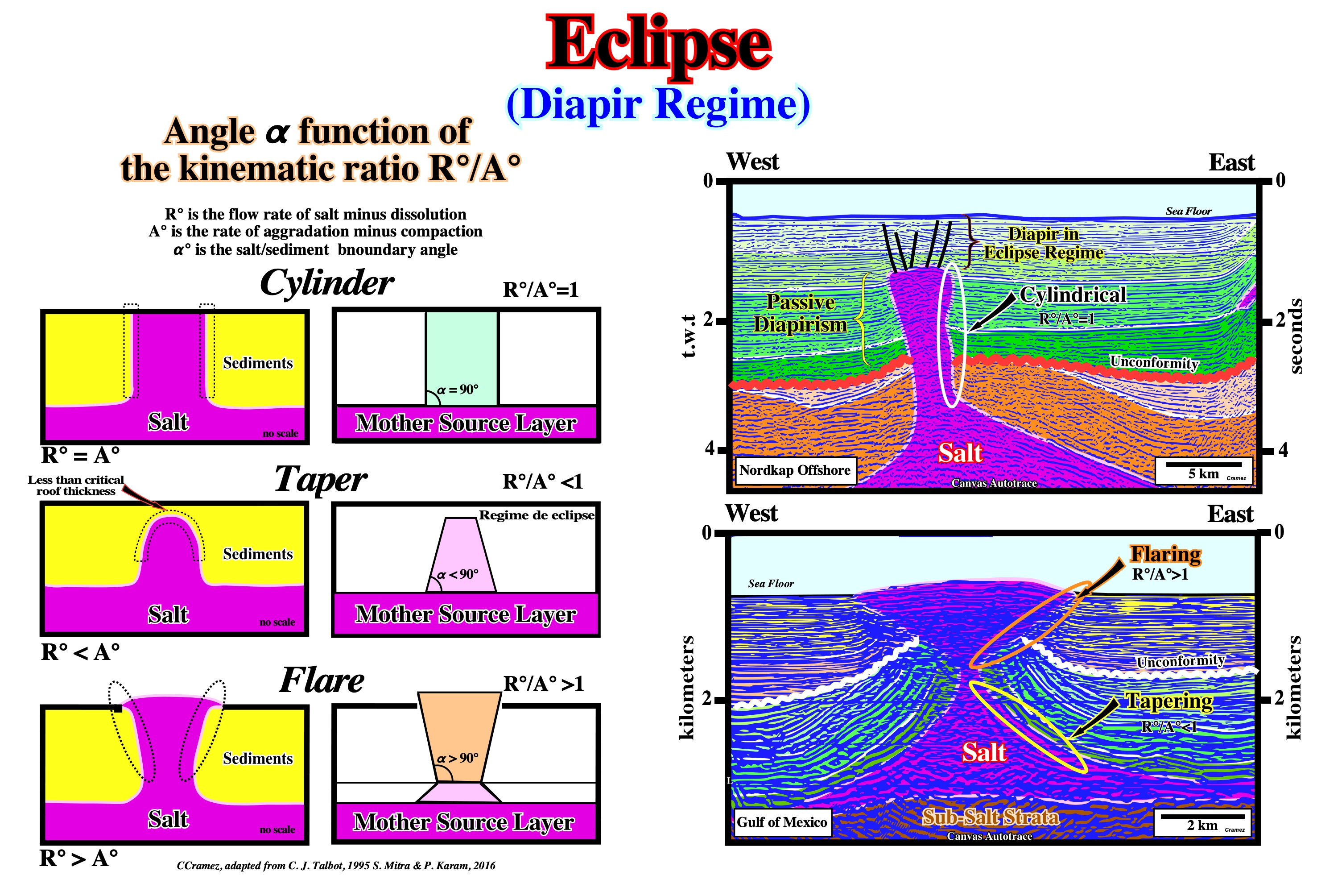
The geometry and evolution of salt diapirs can be defined by angle α° (interface angle between sediments and salt) dependent primarily on the rates of sedimentation (A°) and salt flow (R°): tan (?°/2) =R°/A°. The geological model suggest tapering and flaring are mechanisms for maintaining an equilibrium between net rates of sedimentation (A°) and salt rise (R°), with changing R°/A° values. Flaring is caused by high R°/A°, but is also an effective mechanism of decreasing the rate of net salt rise by increasing the surface area of the top of the diapir. Tapering is caused by low R°/A°, but is also a mechanism for increasing the rate of salt rise by decreasing the diameter. On this basis, the shapes of salt /sediment boundaries can be classified as tapering, cylindrical, and flaring. When the roof of a diapir is above the critical thickness (± 20 % of the total overburden) the diapir is said to be in a regime of eclipse. On the tentative geological interpretations of the Canvas autotraces, the shapes of the diapirs is interpreted taking into account the interface angle between the salt and sediments in cylinder (Nordkapp geographic basin) , taper and flare (Gulf of Mexico).
Effective Stresses Ellipsoid
Ellipsoid of effective stresses are those that deform the sediments. Effective stresses correspond to the addition of the geostatic pressure (σg), pore pressure (σp) and tectonic pressure (σt) and they can be represented by a triaxial ellipsoid. The maximum effective stress is σ1, the medium effective stress is σ2 and the minimum effective stress is σ3.
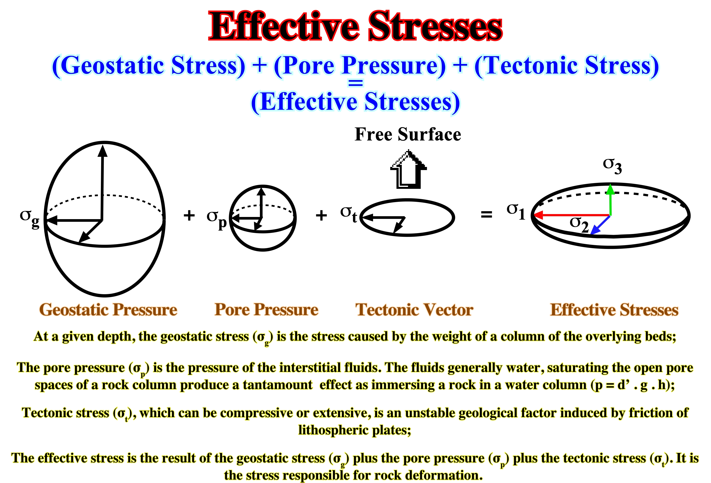
What really deform the sediments are the effective stresses resulting of the combination of the geostatic stress (σg), pore pressure (σp) and tectonic stress (σt) and not the tectonic stress. The tectonic stress alone is not responsible for deformation. With a positive tectonic stress (σt), sediments can be either lengthened or shortened, depending if the geostatic pressure (σg) is big enough to impose a vertical maximum effective stress (σ1).
The consequences of the tectonic stress in a stress field, can be roughly recognized by adding to an initial state of stresses increments of tectonic stress, whether positive (compression) or negative (extensional tectonic stress). The following numerical example is not completely correct, but it can help us to understand how and why rocks are deformed. Let’s start to assume, homogeneous and continuous rocks with an undeformed planar surface, at a middle depth. In addition, let’s assume, that (i) the rocks have a viscous-elastic behavior and (ii) the confining pressure is roughly 8/10 of the geostatic pressure (σh = 8/10 σg). At a given point at 3,000 meters depth, with an average sedimentary density of 2.5 g/cm3 and with an interstitial fluid density of 1.1 g/cm3 (water), we can calculate: a) The geostatic pressure is given by a biaxial ellipsoid , with σvertical = 750 kg/cm2 and σhorizontall = 8/10 of σvertical = 8/10 (750) = 600 kg/cm2; b) The hydrostatic pressure is given by an uniaxial ellipsoid , with σvertical =3000 m x 1,1 g/cm3 x 9,8 m /s ± 330 kg /cm2 and c) The effective vertical pressure is given by the geostatic pressure minus the hydrostatic pressure, i.e., it corresponds to a biaxial ellipsoid, with σvertical = 750 - 330 = 420 kg/cm2 and σhorizontal = 600 - 330 = 270 kg/cm2. Knowing the effective vertical pressure one can now add the tectonic stress. Let’s start adding a negative tectonic stress (σt = -n kg/cm2) along the direction of the horizontal axis Y, and assuming the associated lateral stress (confining pressure), along the perpendicular axis (X), is half (5/10) of the amount of the tectonic stress: a) Adding a tectonic stress of -100kg /cm2 along the axis Y, we get a tridimensional ellipsoid with σ1 = 420 kg/cm2, σ3 = 270 - 100 = 170 kg/cm2, σ3= 270 - 5/10 (100) = 220 kg/cm2. Adding a tectonic stress of -200kg / cm2 along the axis Y, we get a tridimensional ellipsoid with: σ1 = 420 kg/cm2, σ3 = 270 - 200 = 70 kg/cm2, σ3= 270 - 5/10 (200) = 170 kg/cm2. Adding a tectonic stress of -400kg/cm2 along the axis Y, we get a tridimensional ellipsoid with: σ1 = 420 kg/cm2, σ3 = 270 - 400 = -130 kg/cm2, σ2= 270 - 5/10 (400) = 200 kg/cm2. It is relevant to point out that in all previous examples there is no change or rotation of the main axis of the effective stress ellipsoid, only their value changes. Now, let’s add, along the same axis (Y), a positive or compressive tectonic stresses. a) Adding a tectonic stress of 100kg /cm2 along the axis Y, we get a tridimensional ellipsoid with: σ1 = 420 kg/cm2, σ2 = 270 + 100 = 370 kg/cm2, σ3= 270 - 5/10 (100) = 320 kg/cm2. b) Adding a tectonic stress of 200kg /cm2 along the axis Y, we get a tridimensional ellipsoid with: σ2 = 420 kg/cm2, σ1 = 270 + 200 = 470 kg/cm2, σ3= 270 + 5/10 (200) = 370 kg/cm2. c) Adding a tectonic stress of 400kg /cm2 along the axis Y, we get a tridimensional ellipsoid with: σ2 = 420 kg/cm2, σ1 = 270 + 400 = 470 kg/cm2, σ3= 270 + 5/10 (400) = 470 kg/cm2. It is interesting to note than the effective stresses (σ1, σ2,σ3) change with the increments of the tectonic stress. Initially, the maximum effective stress (σ1) is vertical, that is to say, the sediments would be lengthened, but then it becomes horizontal and the sediments would be shortened. The different orientations of the effective stresses are summarized in the figure above.
Ejective Fold Style (Stille, H., 1917)
Tectonic fold style, recognized in the overburden of the Permian Zechstein, characterized by narrow antiforms and broad, flat-bottomed synforms.
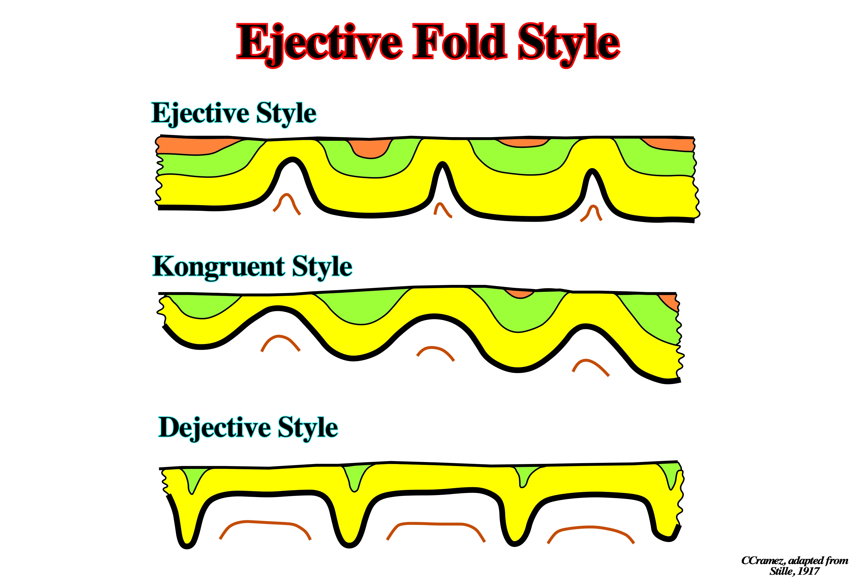
Stille, in 1917, identified three major geometries of folds in the Permian Zechstein : (i) Ejective, characterized by narrow antiforms and broad, flat-bottomed synforms, (ii) Kongruent, characterized by an intermediate geometry between the two end-members, and (iii) Dejective, characterized by narrow synforms and broad, flat-topped antiforms.
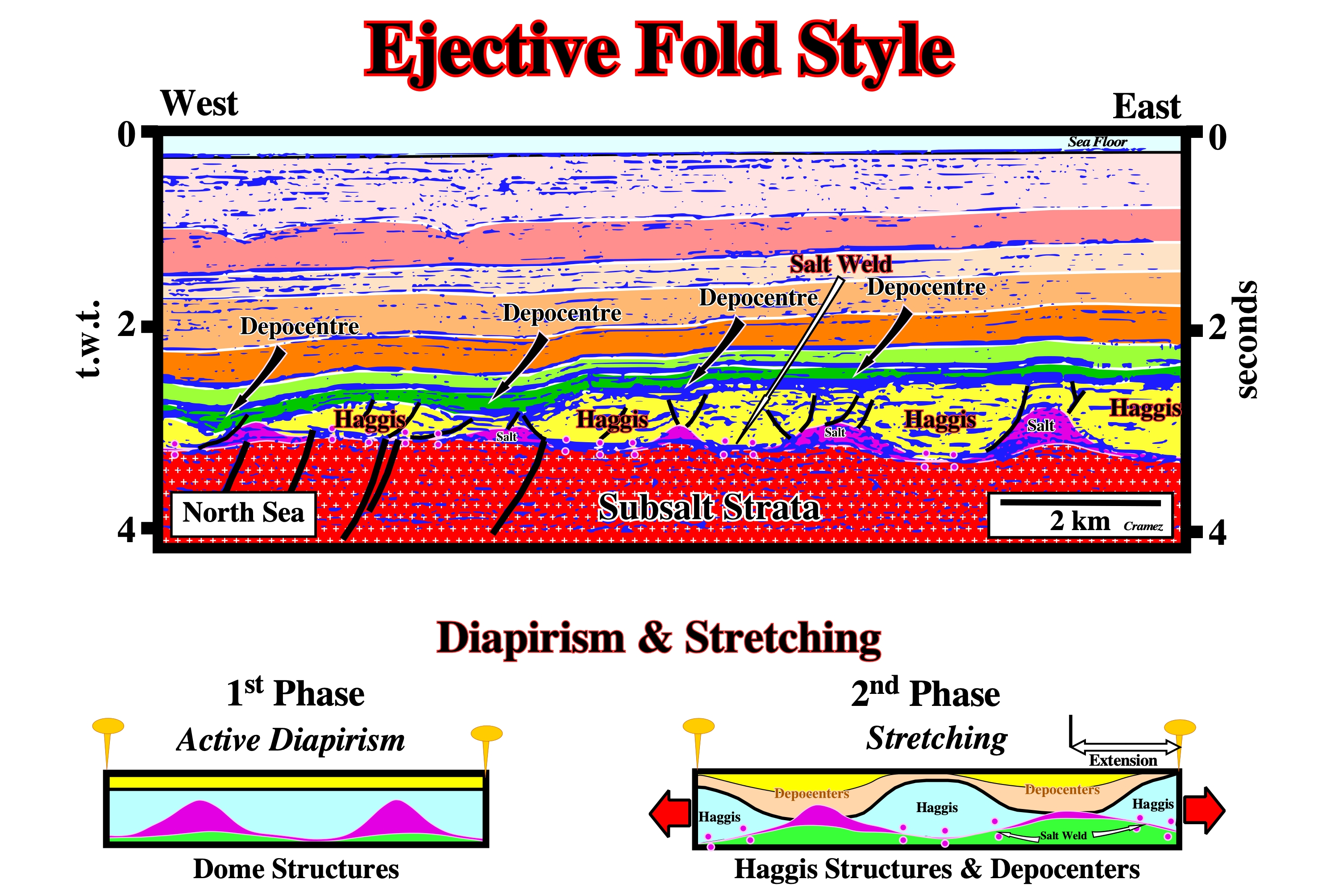
As illustrated on this tentative geological interpretation of a Canvas autotrace of a seismic line of North Sea, the "Haggis structures", as they were called by the old Total’s geoscientists, can be attached to the ejective folds style of Stille, since he does not differentiate compressional folds (salt anticlines) from extensional folds (salt antiforms) structures. In fact, the Haggis structures, before stretching, correspond to, relatively, narrow salt antiforms separated by large depocenters, than after stretching, become inverted antiforms individualized by salt collapse that, obviously created, new depocenters between the Haggis structures.
"En-echellon" Folds
Folds in an overlapping arrangement. Each fold is, relatively, short but they form, collectively, a linear zone, in which the strike of the individual features is oblique to that of the zone as a whole.
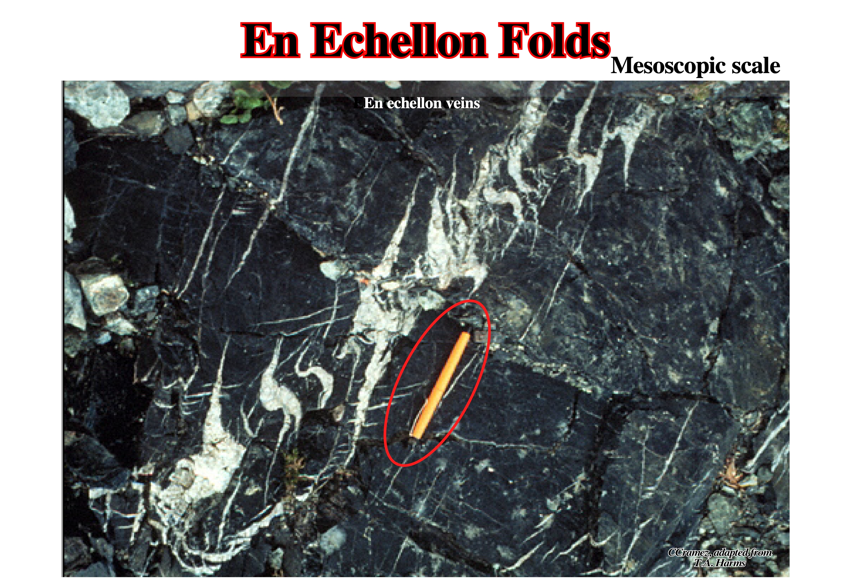
At mesoscopic scale (outcropping scale or scale of continuity), en-echellon geometry is, often, recognized in small scale tension fractures that occur at an angle to a fault and tend to remain open (open-gash fractures). Similar geometry is found at macroscopic scale (scale of the geological maps and seismic lines) as illustrated on the next Canvas autotraces.
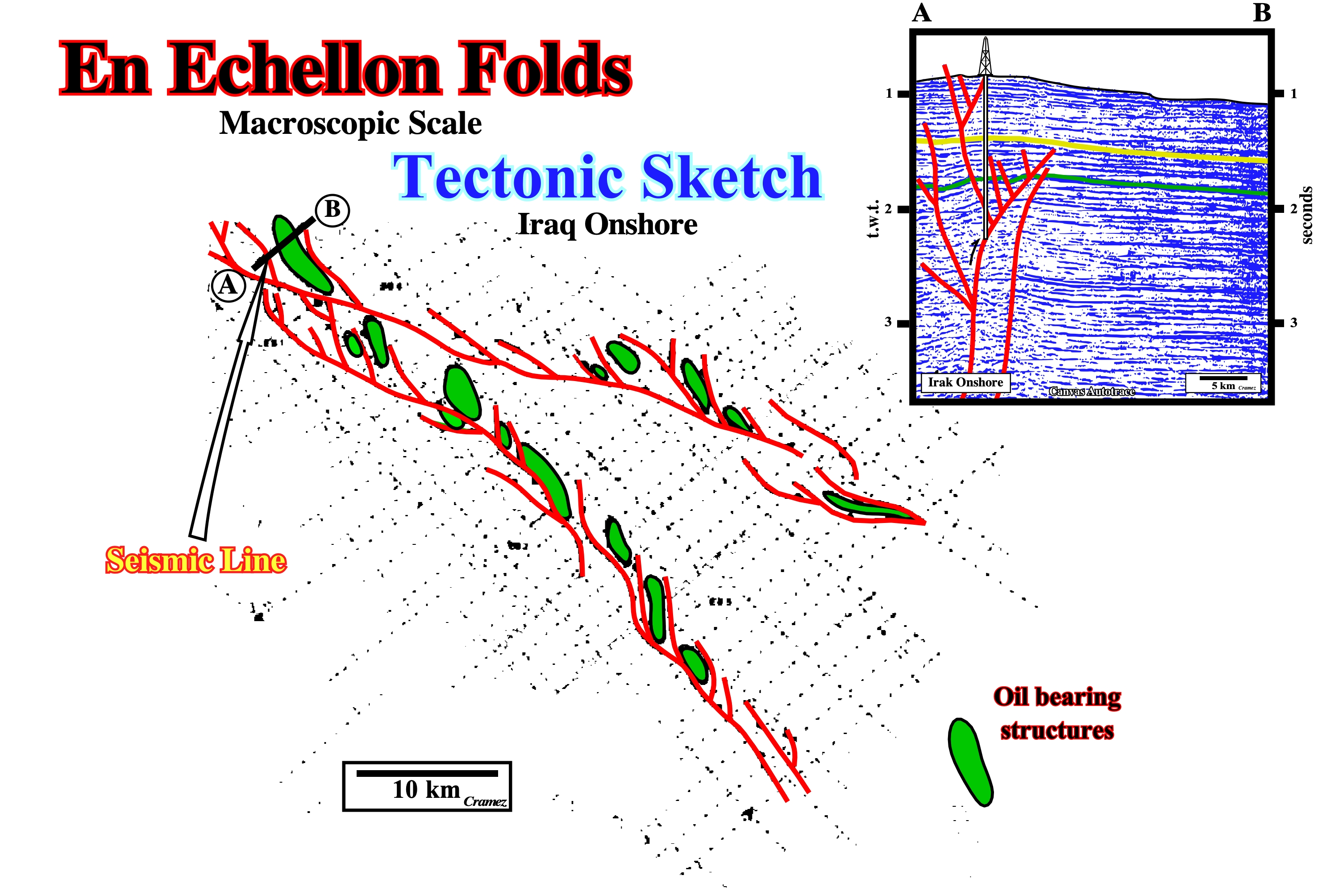
"En-echellon" folds are conical-folds associated with a basement rooted strike-slip faults. During a shortening, induced by a basement rooted strike-slip, depending on the amplitude of the displacement between the faulted blocks, progressively, the sediments show different stages of deformation. In a first step, the sediments are shortened by "en-echellon" fold, then, the "en-echellon folds" are faulted by branched strike-slip faults, which are connected with the major deep basement faults. Finally, when the lateral displacement of the basement blocks is big enough , in surface, the zone of shortening becomes a complex wrench fault, with basement blocks outcropping. On the Canvas autotrace of an Iraq onshore seismic line, which is, roughly. perpendicular to σ1 during the late compressional tectonic regime, it is quite evident that a pre-existing normal fault, recognized by the change in thickness in each side of the fault of the seismic interval bounded by the green and yellow reflectors, was reactivated as reverse fault. The shortening of the sediments is recognized by reverse faulting and folding (buckling). The folding is conical. On parallel seismic lines, the apex of the structures is, progressively, displaced toward or outward of the trace of the major reactivated fault.
Enhanced Unconformity
An eustatic unconformity, i.e., an erosional surface, induced by significant relative sea level falls, which is, locally, are tectonically enhanced. Synonym of Angular Unconformity.
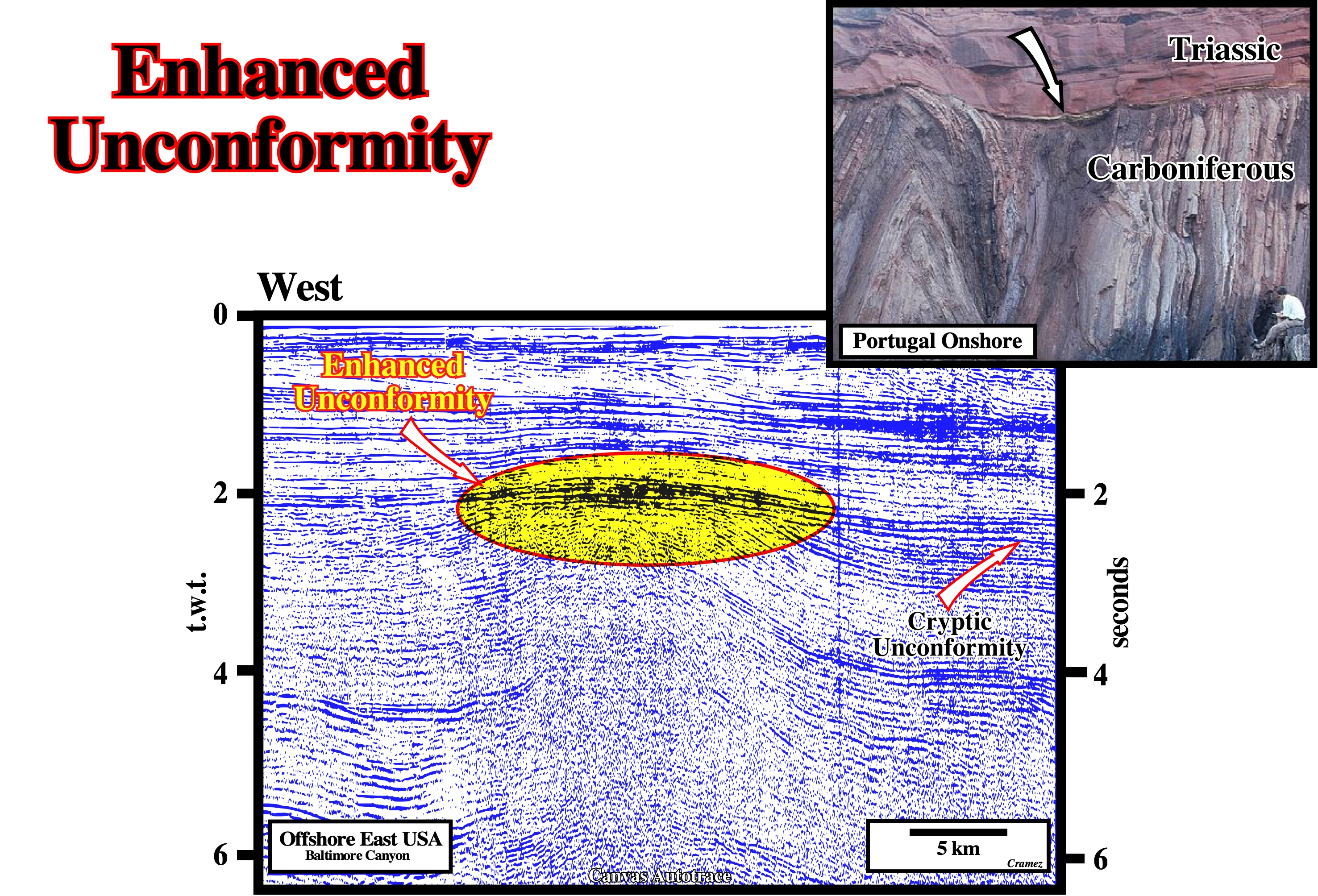
On this Canvas autotrace of a Baltimore Canyon (New Jersey offshore), there is an eustatic unconformity between the Triassic-Jurassic and the Cretaceous-Cenozoic sediments of the continental divergent margin. However, locally, due a volcanic intrusion, this unconformity was tectonically enhanced. Toplaps by truncation are obvious just above the intrusion, but they disappear laterally, i.e., the unconformity was tectonically enhanced by the emplacement of the volcanic (angular unconformity). Laterally, it becomes just a cryptic eustatic unconformity.
Enothem
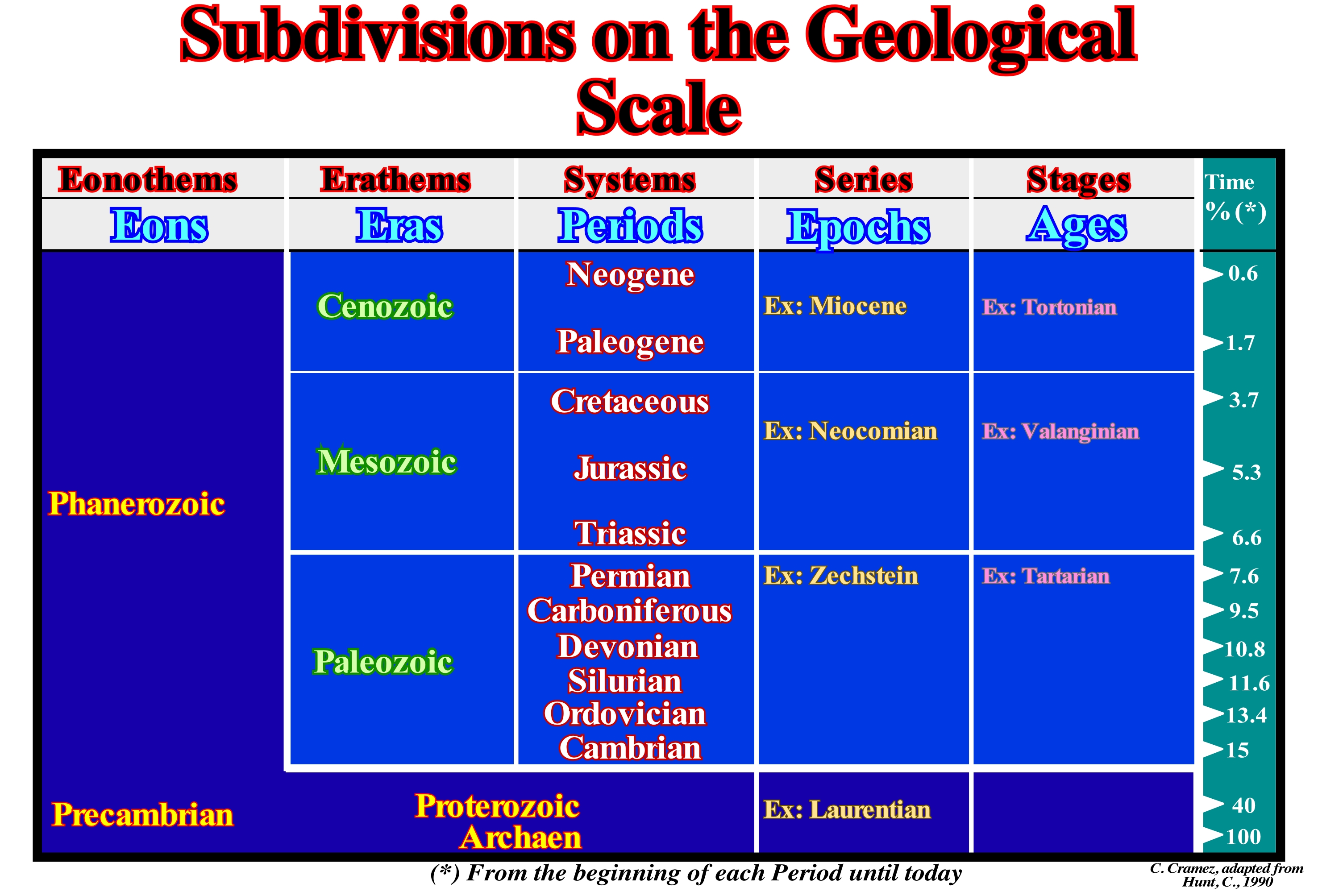
Major stratigraphic unity of the Earth's history. There are two major Enothems (Phanerozoic and Precambrian). Each enothem is composed by different Erathems. Erathems are composed by Systems, which can include several Series composed by Stages.
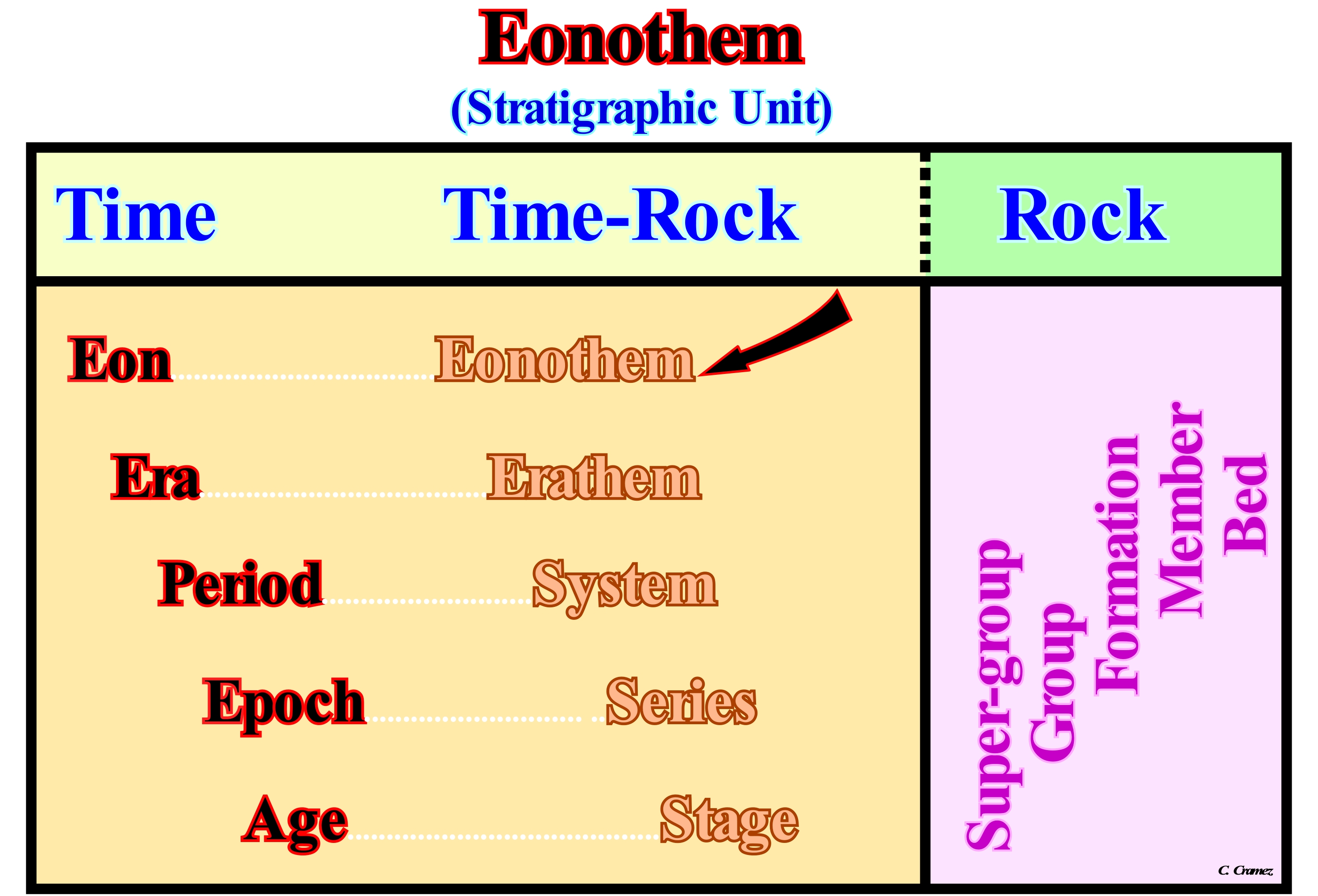
Shenck and Muller (1941) emphasized the fact that rock units have no explicit time connotation by showing them at right angles to the time and time–rock units. The equivalence time units and their corresponding time-rock units is shown above by the dotted lines. It can be said Cretaceous System consists of all rocks deposited during the Cretaceous Period.
Geological time can be divided in Eons, Eras, Periods, Epochs and Ages. The duration of each Period since Archaeozoic (100 %) is indicated in percentage. For instance, the Cretaceous Period represents 3.7% of the of the total age of the Earth (± 4.5 Ga). The stratigraphic equivalents of the time divisions are: Enothems, Erathems, Systems, Series and Stages.
Intestine-like folds, apparently, originated, mainly, by volume changes, such as hydration of anhydrite to gypsum, which involves a 61% increase in volume. Actually, they are associated with: (i) Volume changes ; (ii) Diagenesis ; (iii) Minor folding by gravity and (iv) Large scale folding.
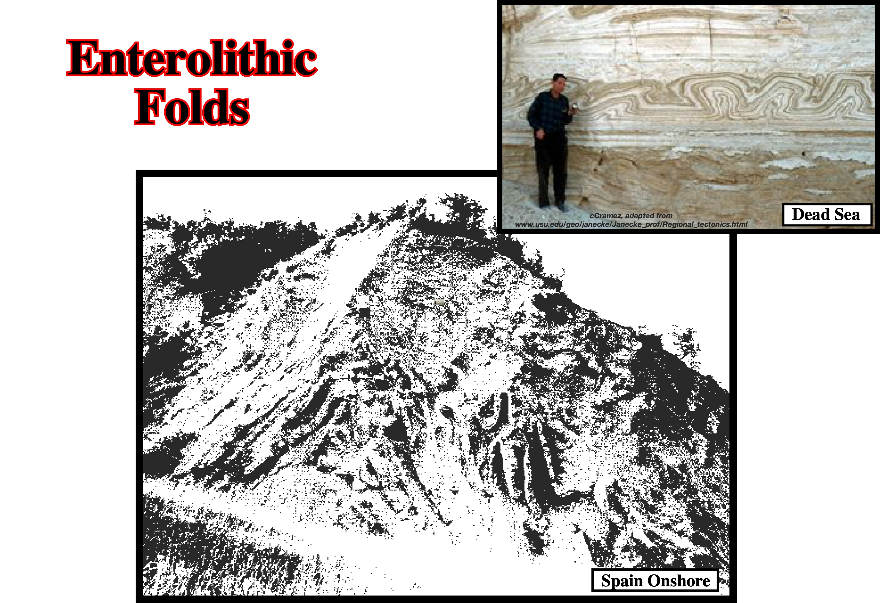
Enterolithic fold are also induced by gravity. They are quite common in slope environments, as in the the fold belt along French-Spanish border.
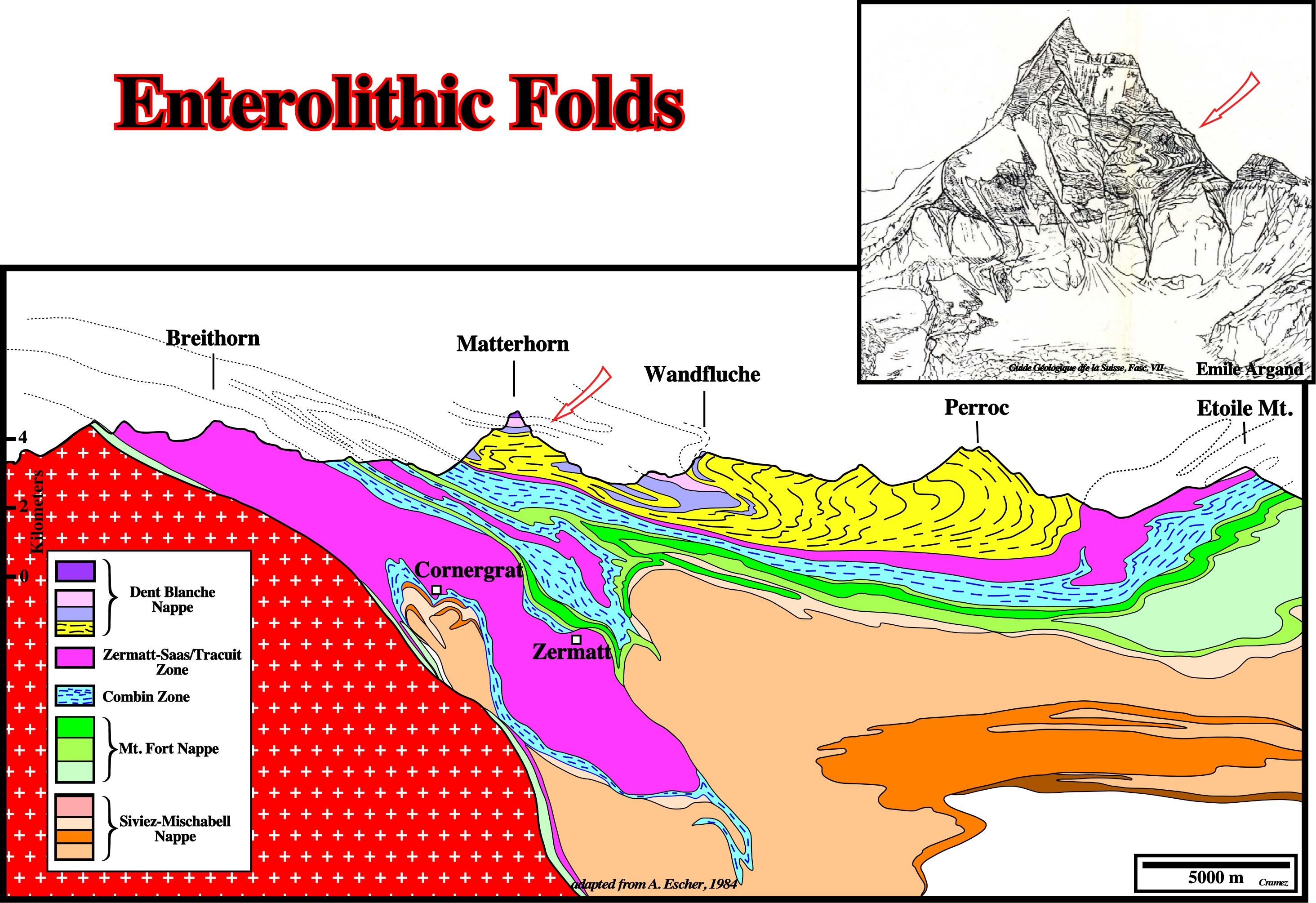
Since for many geoscientists the term enterolitic as non genetic meaning, but just geometric, at macroscopic scale, the folding observed on this geological cross section of the Valaisian Alpes, can be considered as enterolithic.
Eon
See: Enothem.
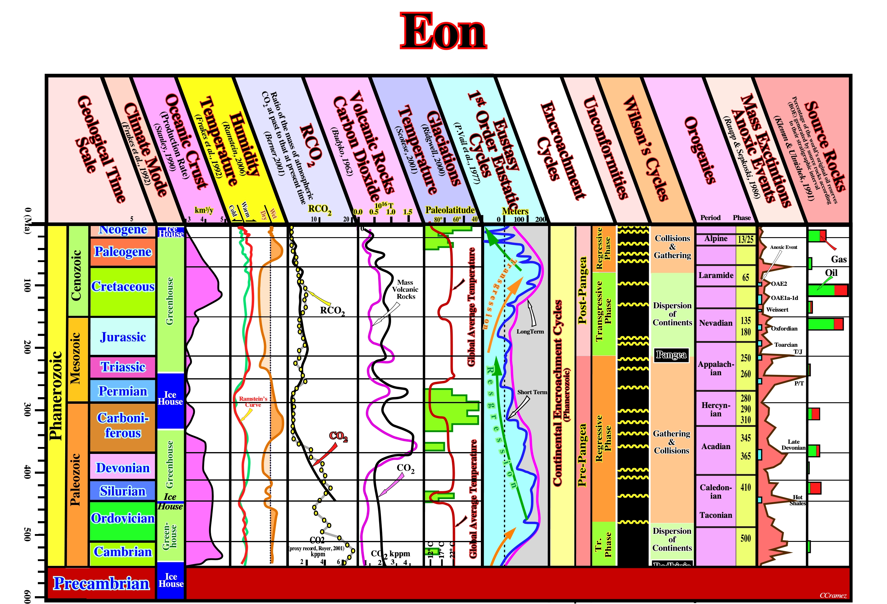
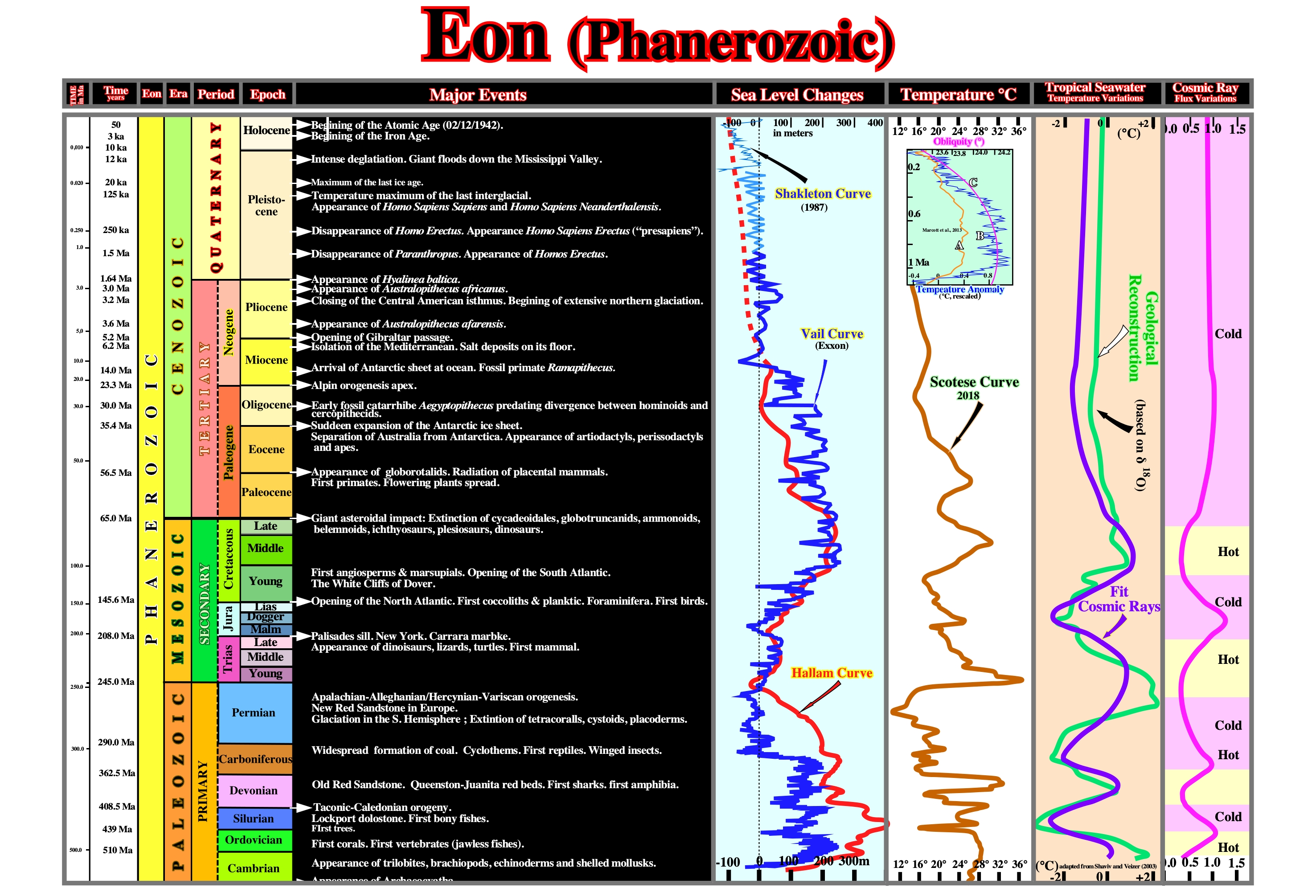
Long span of geological time. In formal usage, eons are the longest portions of geologic time (Eras are the second-longest). Three eons are recognized: the Phanerozoic Eon (dating from the present back to the beginning of the Cambrian Period), the Proterozoic Eon , and the Archean Eon. Less formally, eon refers, often, to a span of one billion years. On this plate are depicted the main geological fractures of the Phanerozoic eon. It is particularly interesting to note that it is formed by two continental encroachment cycles induced by two 1 st order eustatic cycles. Each eustatic cycle corresponds to a Wilson's cycle. The sea floor spreading is minimum during the formation of the supercontinents Rodhinia (Protopangea) and Pangea. The maximum rate of oceanization is during eustatic highs. The CO2 content decreased, continuously, till today (± 8,000 ppm to ± 380m ppm). During the Phanerozoic the climate change a lot. Five glacial periods are, easily, recognized. Several mass extinction took place during this eon, in which the more likely marine organic rich sediments (potential source rocks) seem to be associated with eustatic highs.
The first thing to take into account on this plate is that the geological time scale is not linear (the Quaternary period is very dilated). Its was proposed by C. Emilani (1992) and adapted to the age of the its major geological event. The Quaternary sea level and temperature curve are detailed. The Scotese's temperature curve, clearly, indicates two trends of temperature decreasing. Since the Late Permian the temperature decreased till the last glaciation (Holocene). In the Holocene global temperature change reconstruction, the A curve (in red) is global average temperature reconstruction from Marcott et al., 2013, the B curve (in blue). is global average temperature reconstruction from Marcott et al., 2013, using proxy published dates, and differencing average. Temperature anomaly was rescaled to match biological, glaciological, and marine sedimentary evidence, C curve (in purple) is Earth’s axis obliquity, which shown to display a similar trend to Holocene temperatures. Using the deep cores, Shaviv, N. and Veizer (2003) show the proportions of isotopes Be10 , Cl36 and C14 gives a good indication of the irradiation of the Earth by the cosmic rays of high energy. The proportion of the isotopes O16 -O18 and the variation of the fossils fauna allow a temperature estimation. It is easy to see the concordance between the temperature variations and the ionizing irradiation. Since the beginning of the Phanerozoic until today four major warm geological periods, with time duration ranging between 50 and 100 My, alternate with four cold periods.
Epeirocraton
A stable, continental craton, including both continental shield and platform. Synonym of Hedreocraton.
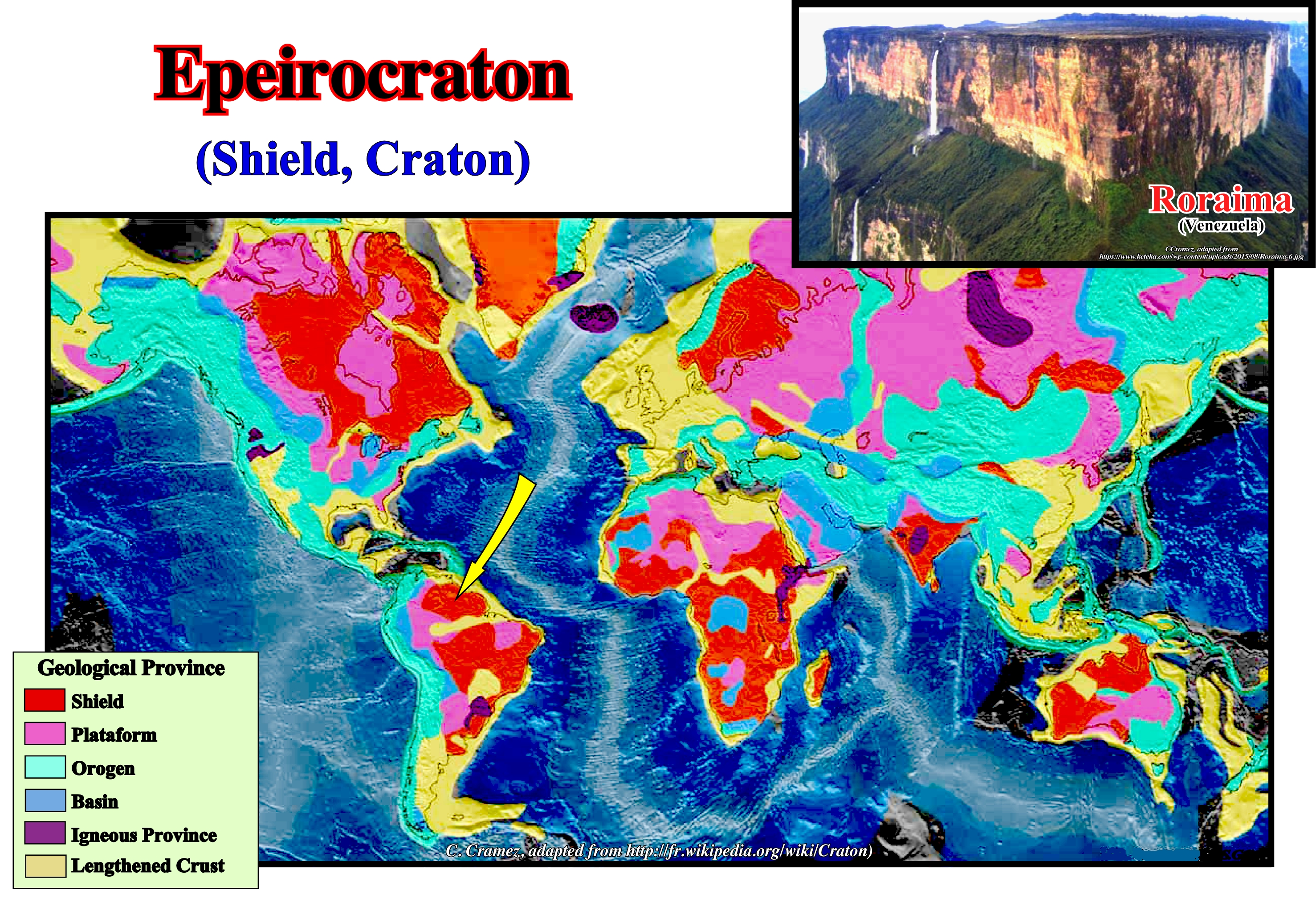
Following Kober (1928), who make a clear distinction between continents (“epeirogenic”) and ocean basins (“oceanogenic”), Fairbridge, R. A. (1955) considered epeirocratons and thalassocratons to emphasize the crustal differences. Within the epeirocratons are recognized the following second-order morphotectonic units: the ancient shields (cratons), younger orogenic chains. In Northern Hemisphere, the most important cratons are: (i) Angara (Western Siberia crater) ; (ii) Scandinavia (encompassing Northern Europe) and (ii) Canadian Shield (encompasses the northern regions of Saskatchewan, Manitoba, Ontario and Quebec, as well as most of Labrador). In Southern Hemisphere, the main cratons are: (a) African (encompasses five continental masses, from the Precambrian, which came together at the end of Precambrian and early Paleozoic to form the African continent: West Africa, Kalahari, Congo, Sahara and Tanzania) ; (b) Antarctic (covering about 10 Mkm 2, i.e., 73% of the Antarctic continent, but is almost entirely buried by the Antarctic East ice cap ; it is formed by Mawson craton and several other marginal cratons) ; (c) Australian (composed of a whole series of craters including: Altjawarra, Central, Curnamona, Gawler, Pilbara, Yilgarn, etc.) and (d) Brazilian (the Guiana craton (Roraima is shown in this figure) and Central Shield of Brazil constitute, respectively, the exhumed parts of the north and south of the craton ; smaller cratons are found southward, as the Plata River craton and San Francisco craton).
Episutural Basin (Bally and Snelson,1980)
Basin located within the megasutures, as Backarc, Californian-type, Pannonian, Mediterranean, etc.
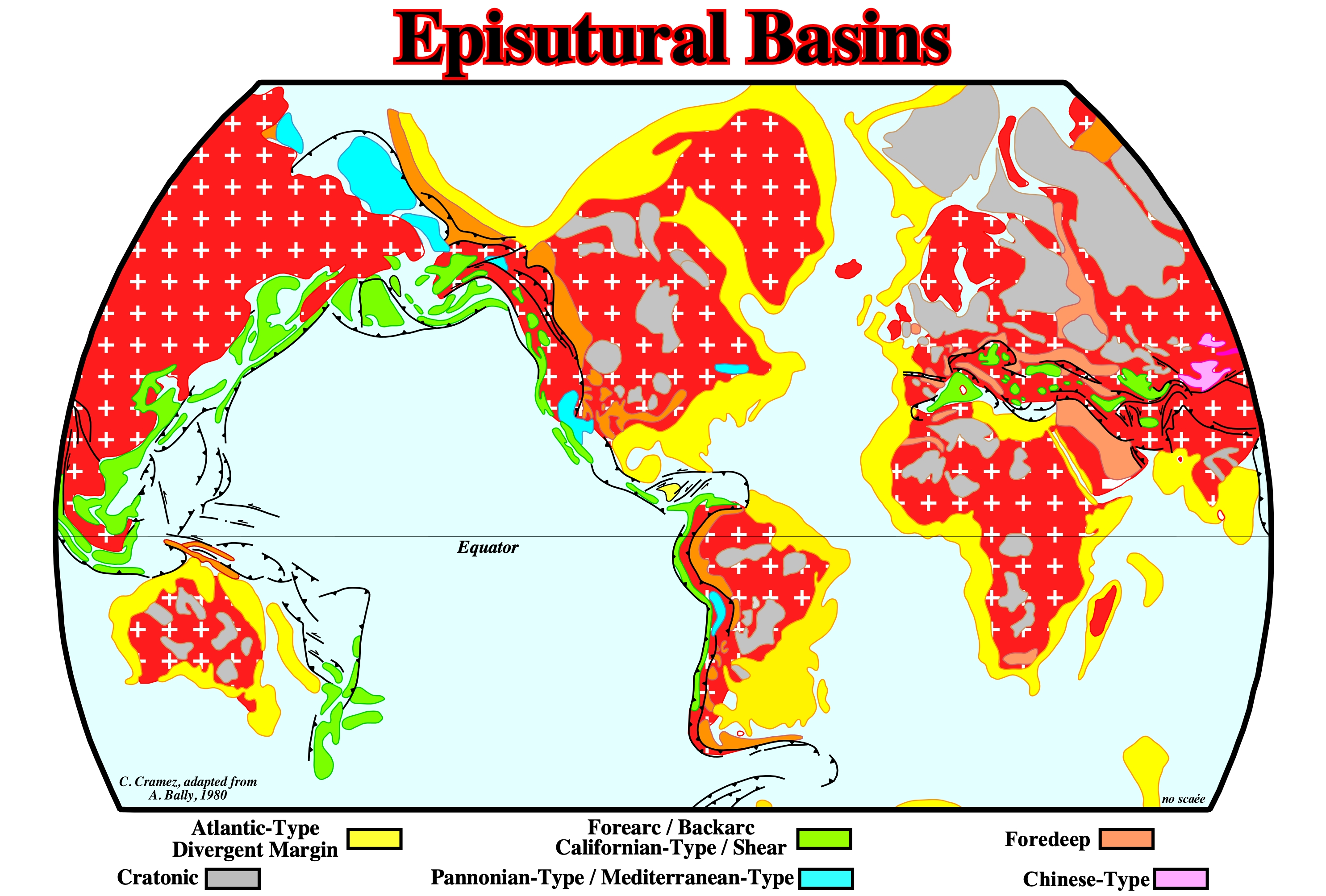
The main episutural basins are colored green and blue: (i) Forearc and backarc basin, as their names suggest, are associated with volcanic arcs ; (ii) Californian and Shear basins are associated with large lateral displacement ; (iii) in Mediterranean-type basins there is oceanization, while in a Pannonian-type there is not.
Equilibrium Tectonic Regime
Extensional tectonic regime characterized by an effective stresses ellipsoid with σ1 vertical and σ2 and σ3 horizontal but equal. The sediments are lengthened by normal faults striking in all azimuths since the ellipsoid is biaxial. It is under this tectonic regime that halokinesis takes place when a significant salt layer is present in the stratigraphic column.
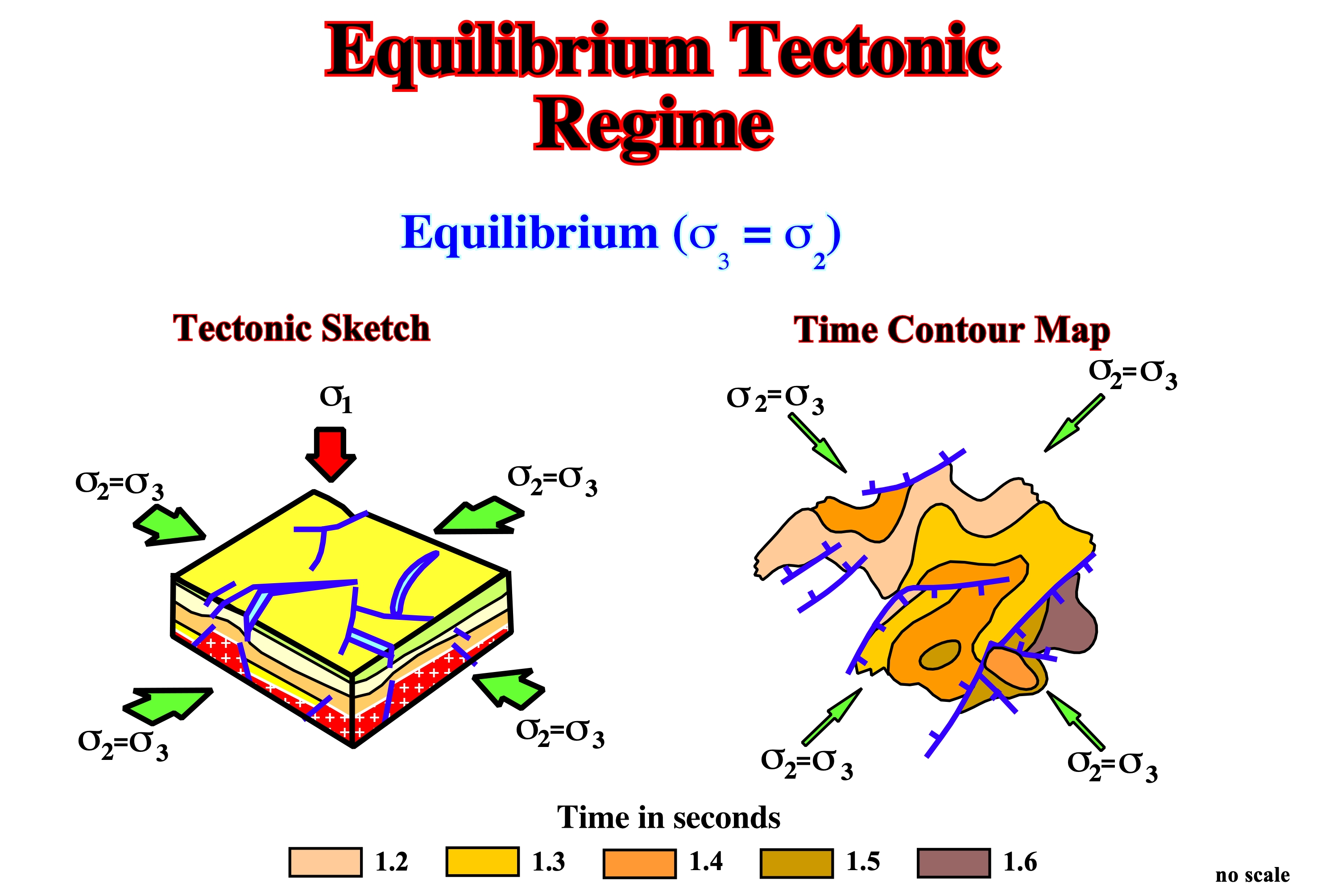
This tectonic regime is often recognized above buried hills (differential compaction), salt domes and volcanic intrusions. According to the Mohr's theory, when σ1 = σ2, faults strike in all direction (radial faults).
Erathem
See: Enothem.
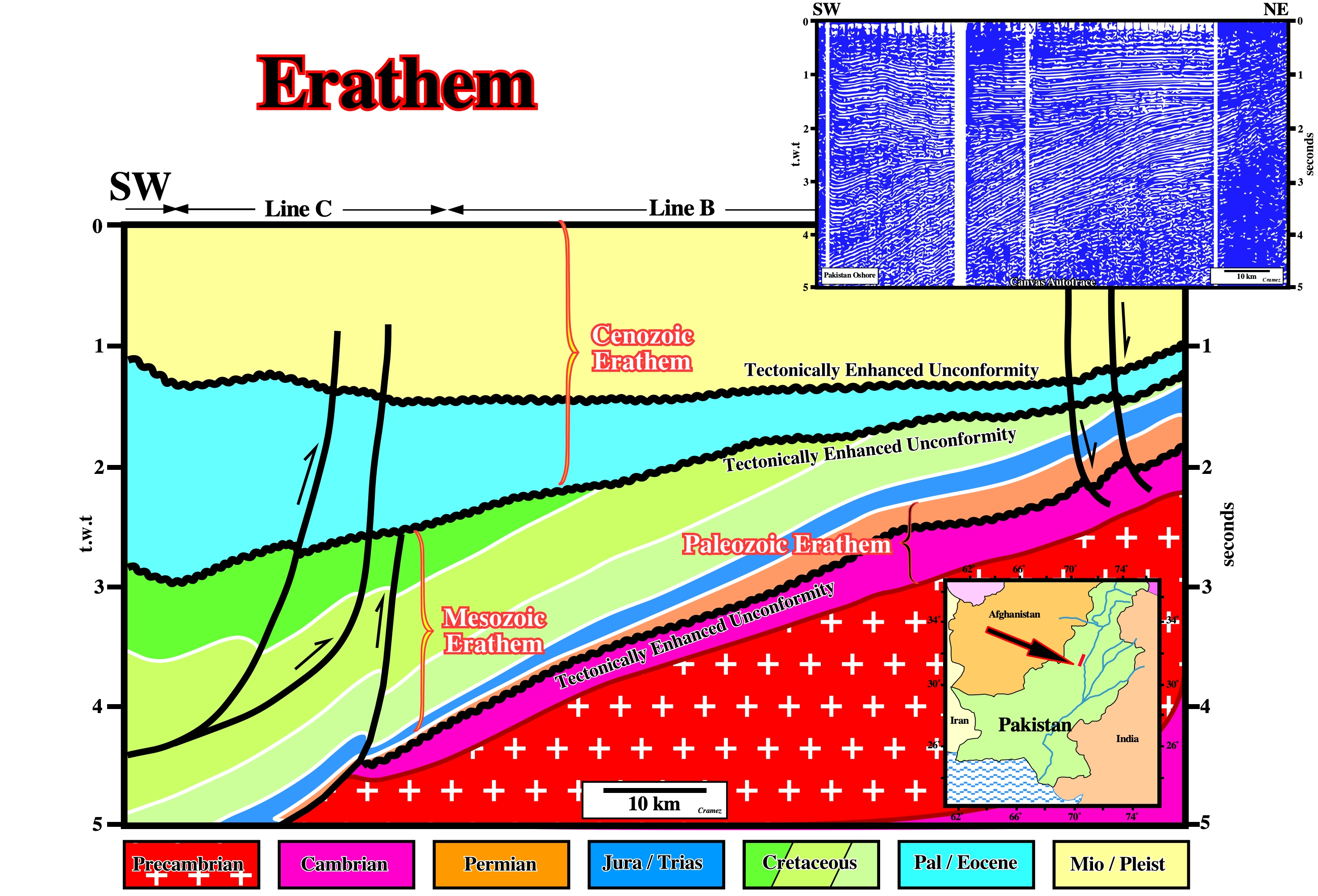
On this tentative geological interpretation of a Canvas autotrace of the Pakistan onshore seismic line, the rocks associated with the yellow-blue interval form the Cenozoic erathem. Similarly, the rocks deposited during the Cretaceous, Jurassic and Trias geological periods form the Mesozoic erathem. Do not forget: Era is for geological time, while Erathem is for the rocks deposited during an Era.
Eustacy
Synonym of Eustasy. This term is not recommended.
Eustasy
The worldwide sea-level regime and its fluctuation, caused by absolute changes in the quantity of seawater (glacio-eustasy) or volume of the oceanic basins. Since 1977, the definition of Eustasy more difficult to falsify is: Vertical Sea Level Changes regardless their Causes (A. Mörner, 1977). Can be also spelled Eustacy.
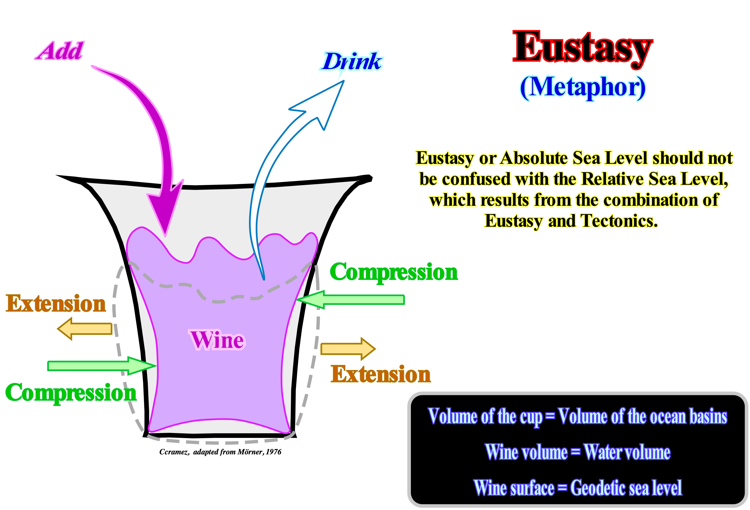
The eustasy can be simulated by the variations of level of wine in a cup (Mörner, 1976). The size of the cup simulates the ocean basin volume, which can be changed by compressing and expanding the cup (earth movements simulation) causing the rise and fall. The rise and fall of the wine's surface simulates tectono-eustasy. The wine volume in the cup can be changed by drinking and refilling (climate) ; giving rise to corresponding rises and falls in the wine level (glacio-eustasy). Do not forget that function of the reference surfaces taking into account and the points on which we desire to measure the sea level, three main sea level types can be considered: (i) Absolute or Eustatic Sea Level ; (ii) Relative Sea Level ; (iii) Sea Surface Height. In a certain point of the sea level surface, the absolute (eustatic) sea level, which is the distance between such a point and the Earth’s center, is a function of Tectono-Eustasy, Glacio-Eustasy, Geoidal-Eustasy and Thermal Expansion of Oceans. The relative sea level, in a given point of the sea floor, is the distance between such a point and the sea level surface. On seismic lines, a relative sea levels can be, also, determined by the vertical distance between a given point on the sea level surface and the base of the sediments (top of the continental crust) taken as reference surface. One can say, the relative sea level is the result of the combined action of the absolute (eustatic) sea level and the tectonics (subsidence or uplift of the sea floor). The sea surface height, in a given point of the sea surface, is the distance between such a point of the ellipsoid of reference.
Eustatic Cycles
Five orders of eustatic cycles were identified in the geological record. They were designated as 1st to 5th order cycles. First order eustatic cycles correspond to continental flooding cycles defined on the basis of major times of encroachment (landward extension) and restriction of sediments onto the cratons. They are associated with the breakup of supercontinents. They are recognized on all continents and they are believed to be global. Their time duration is higher than 50 My, which Vail takes as the minimum duration for a 1st order cycle. Eustatic cycles of 2nd to 5th border are believed to be caused by smaller magnitude, but higher frequency, and more rapid rates of eustatic change. They cause high frequency variations on the relative change of sea level curve (eustasy + tectonics).
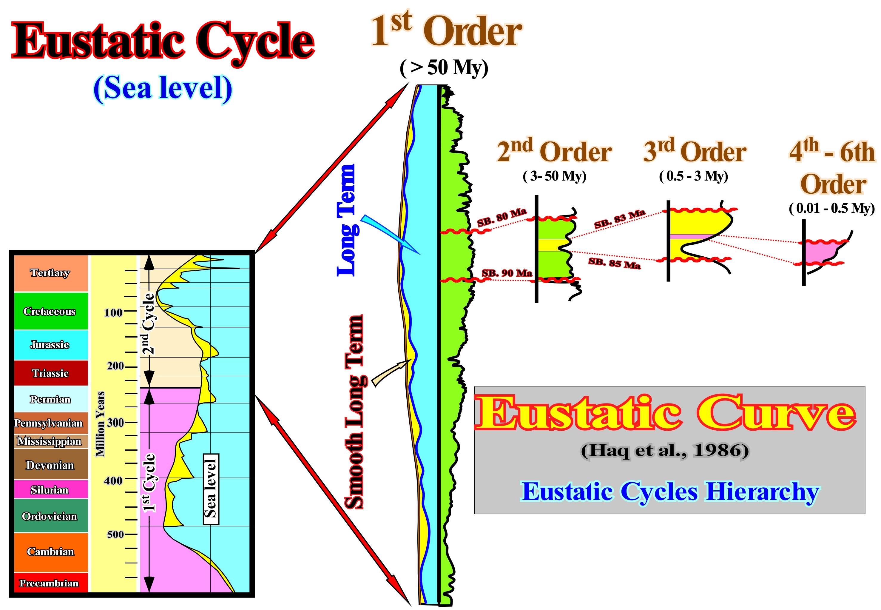
In spite of the fact time duration of the eustatic cycles have changed since the birth of sequential stratigraphy, the majority of geologists assume the following time duration: (1) More than 50 My for 1st order eustatic cycles ; (2) 3 to 50 My for 2nd order cycles ; (3) 0.5 to 3.0 My for 3rd order cycles and (4) 0.1 to 0.4 My for 4th and 5thorder cycles. The classification of eustatic cycles into different orders clearly illustrated that P. Vail and co-authors considered Eustasy as a multi-leveled complex geological structure in which each eustatic cycle forms a whole with respect to its parts while at same time being a part of a larger whole (Systemic approach).
Evaporites
A non-clastic sedimentary rock composed primarily of minerals produced from a saline solution as a result of extensive or total evaporation of the solvent. Examples include: gypsum, anhydrite, rock salt, primary dolomite and various nitrates and borates.
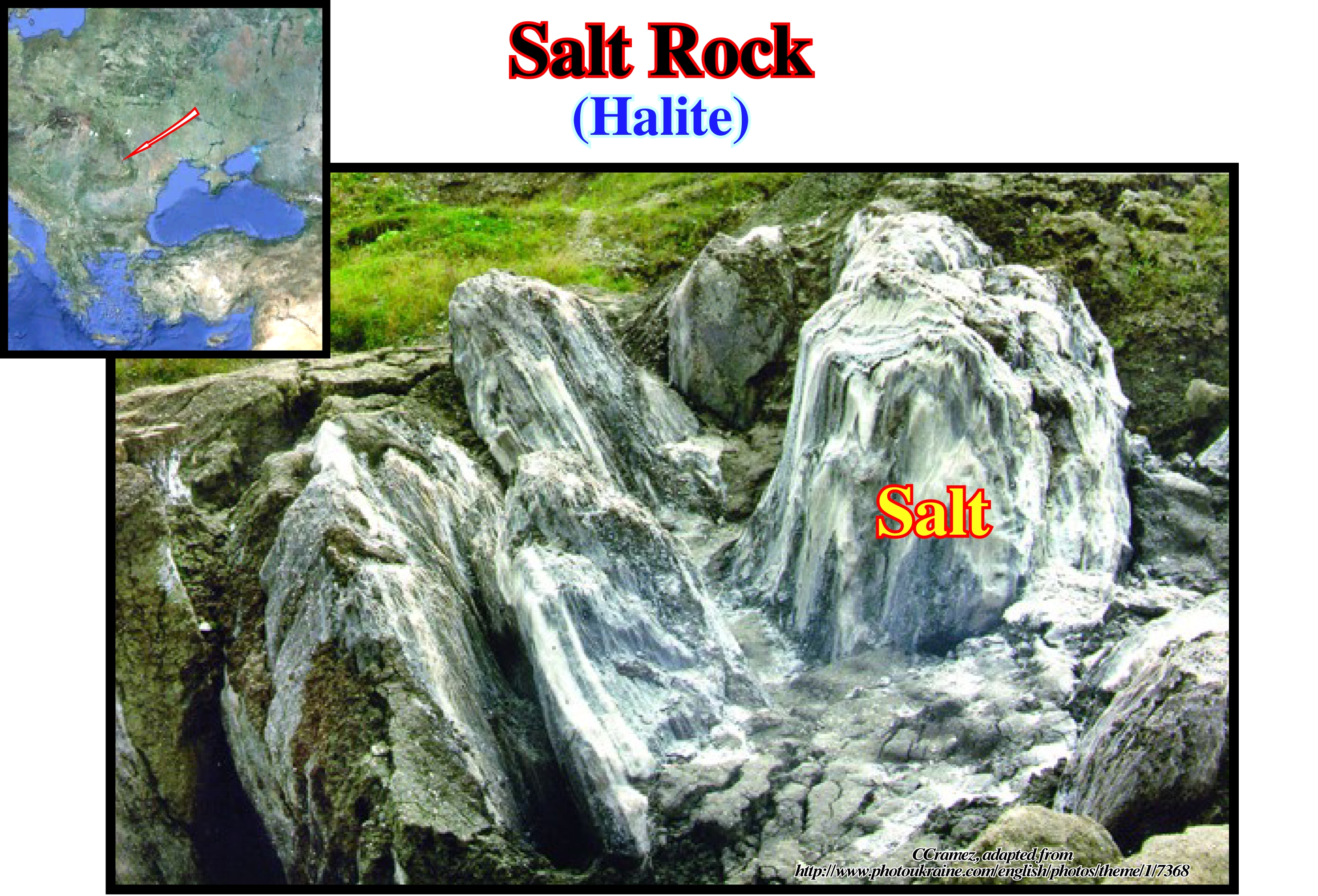
Halite, which is one of the main constituents of evaporites, and particularly the table salt, is typically colorless, but certain occurrences provide red, yellow, blue, etc; colors owing to impurities and /or color centers in the structure. Salt and other evaporite material are sedimentary rocks that play special roles in geological deformation. Compared to other rocks they have : (i) Low and almost depth independent density (2.17 to 2.1 g/cm3), depending on the composition ; (ii) low equivalent viscosity (1,018-1,021 Pa.s) ; (iii) Very easily become ductile and mobile ; (iv) Behave almost like a Newtonian fluid over the geologic time scale and their movement is aided if a small amount of free water is present and / or temperature increases . In addition they are, as crystalline rocks, relatively incompressible (http://www.files.ethz.ch/structuralgeology /JPB/files/English/12diapirs.pdf).
Expansion Center
Roughly, it corresponds to a mid-oceanic ridge, which is an elongated, steep-sided elevation of the oceanic floor, along which oceanic accretion takes places by a moving-away of the new material at rates of one to ten centimeters per year.
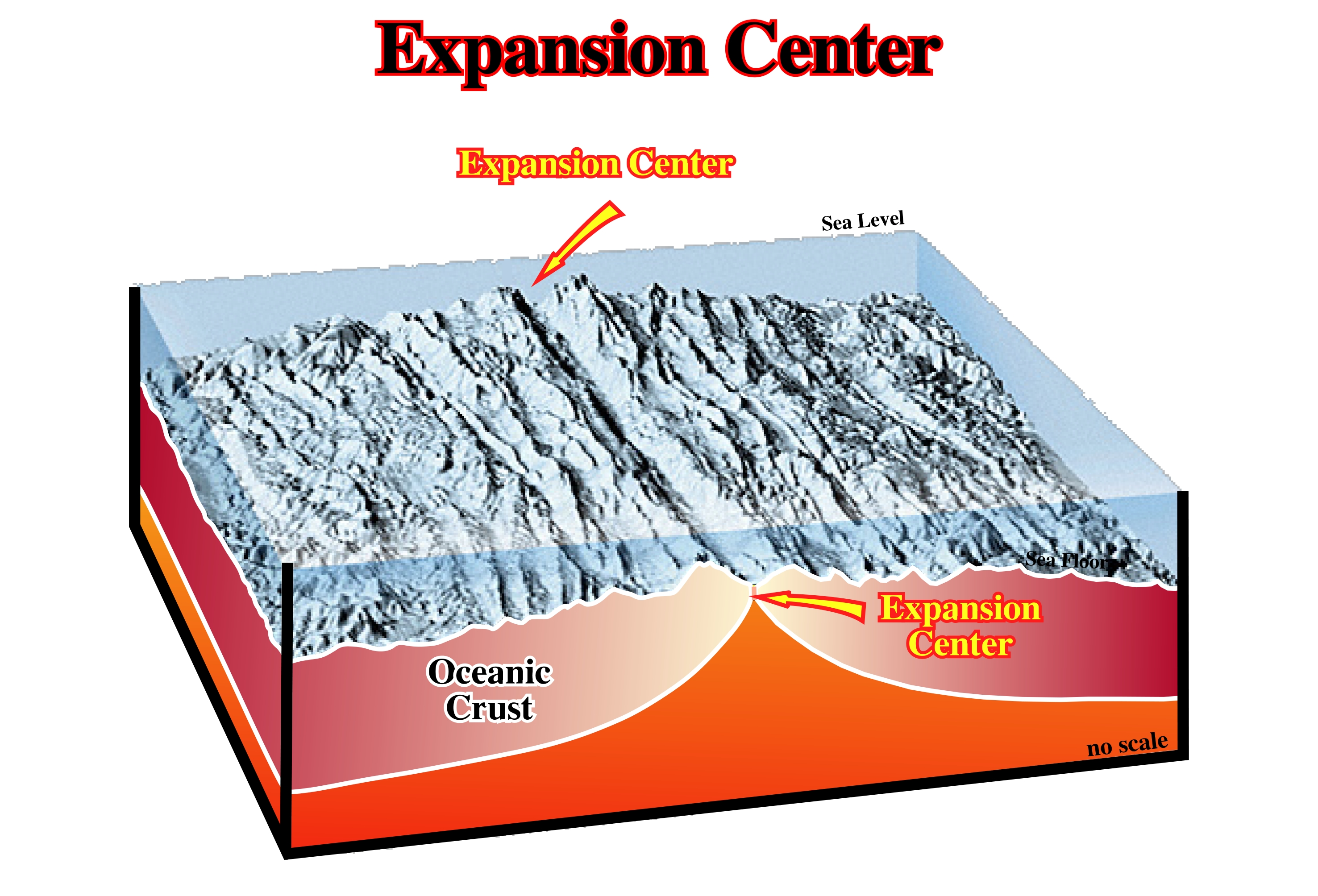
Generally, the expansion centers are located at limit of divergent lithospheric plates, where the astenosphere (upper mantle) is subcropping, as illustrated in this geological sketch.
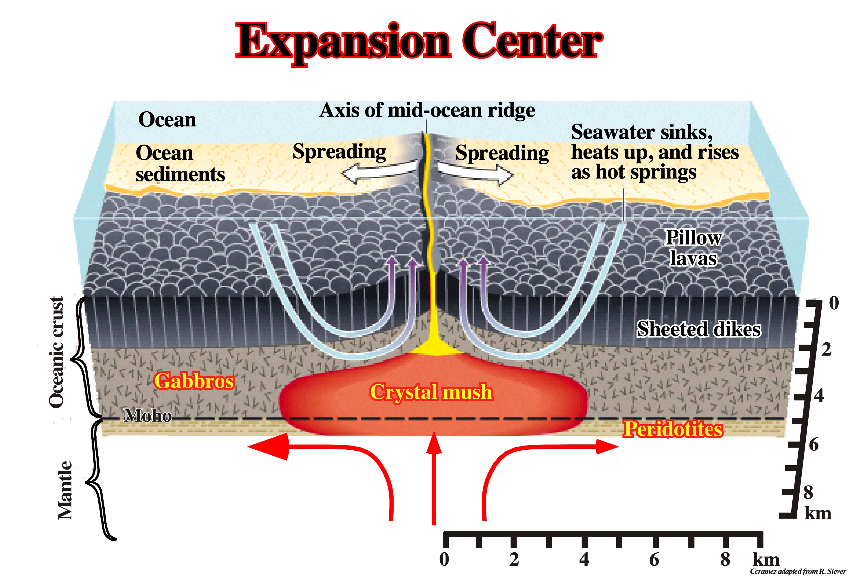
The majority of the expansion centers are oceanic, but there also subaerial expansion centers with associated lava flows. When an subaerial expansion center become oceanic, the expansion and accretion of the lithospheric plates is made by injection of dikes; it is the onset of the oceanic crust. The vertical geometry of the oceanic crust (volcanic dikes), favors the recognition of the magnetic anomalies, which is not the case when the volcanic crust is composed by lava flows (SDRs), i.e., when the expansion centers are subaerial.
Extensional Tectonic Regime
Tectonic regime characterized by an ellipsoid of effective stresses with the maximum effective stress vertical (σ1). Under an extensional tectonic regime, sediments are lengthened by normal faults striking parallel to the medium effective stress (σ2).
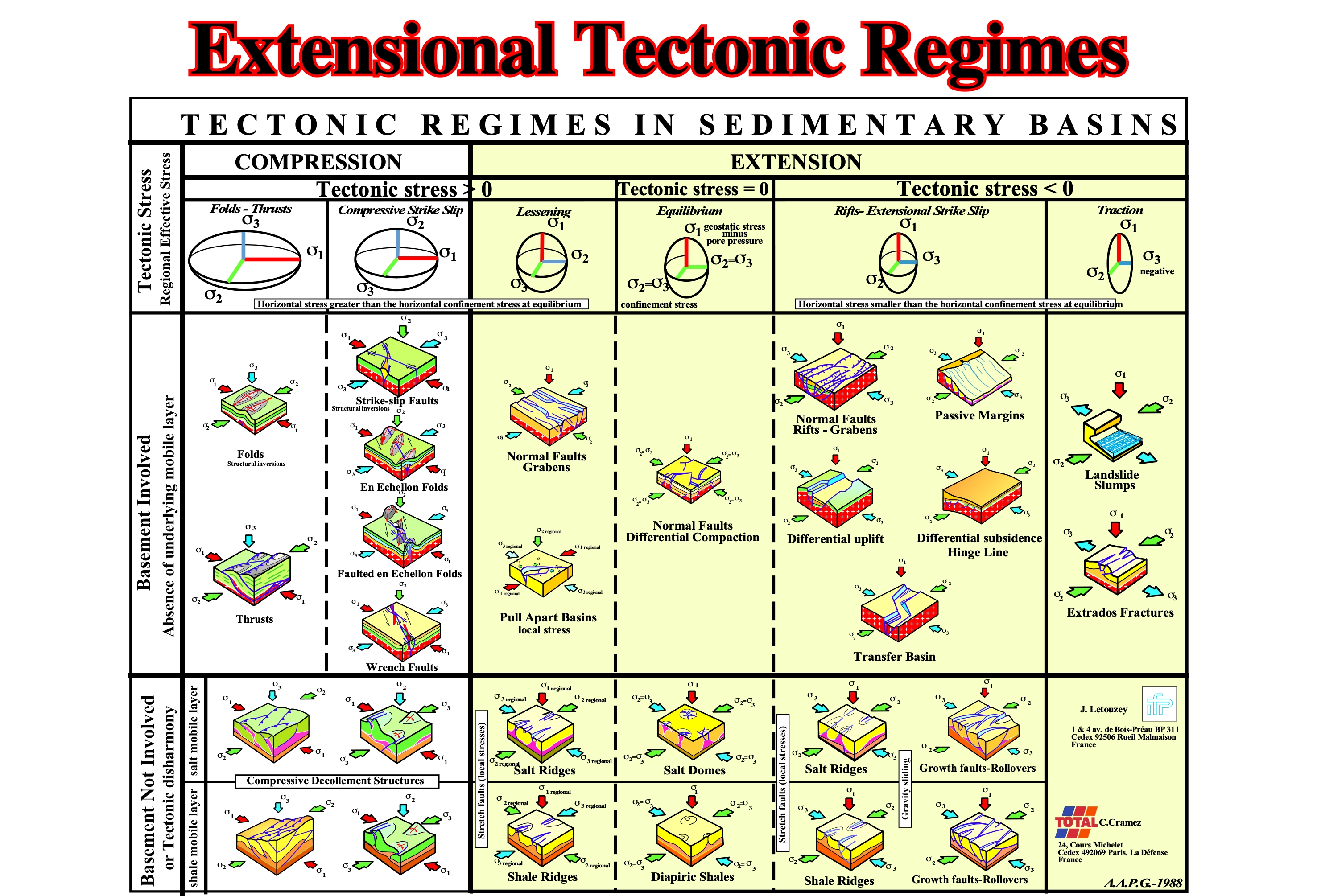
Extensional tectonic regime can be created with a tectonic stress positive (σt> 0), a tectonic stress nil (σt= 0) and a tectonic stress negative (σt < 0), therefore there is no reason to associated a sedimentary lengthening with the tectonic stress.
External Mushroom Structure
Structure in which skirts surround antiformal, infolded synclines of overburden.
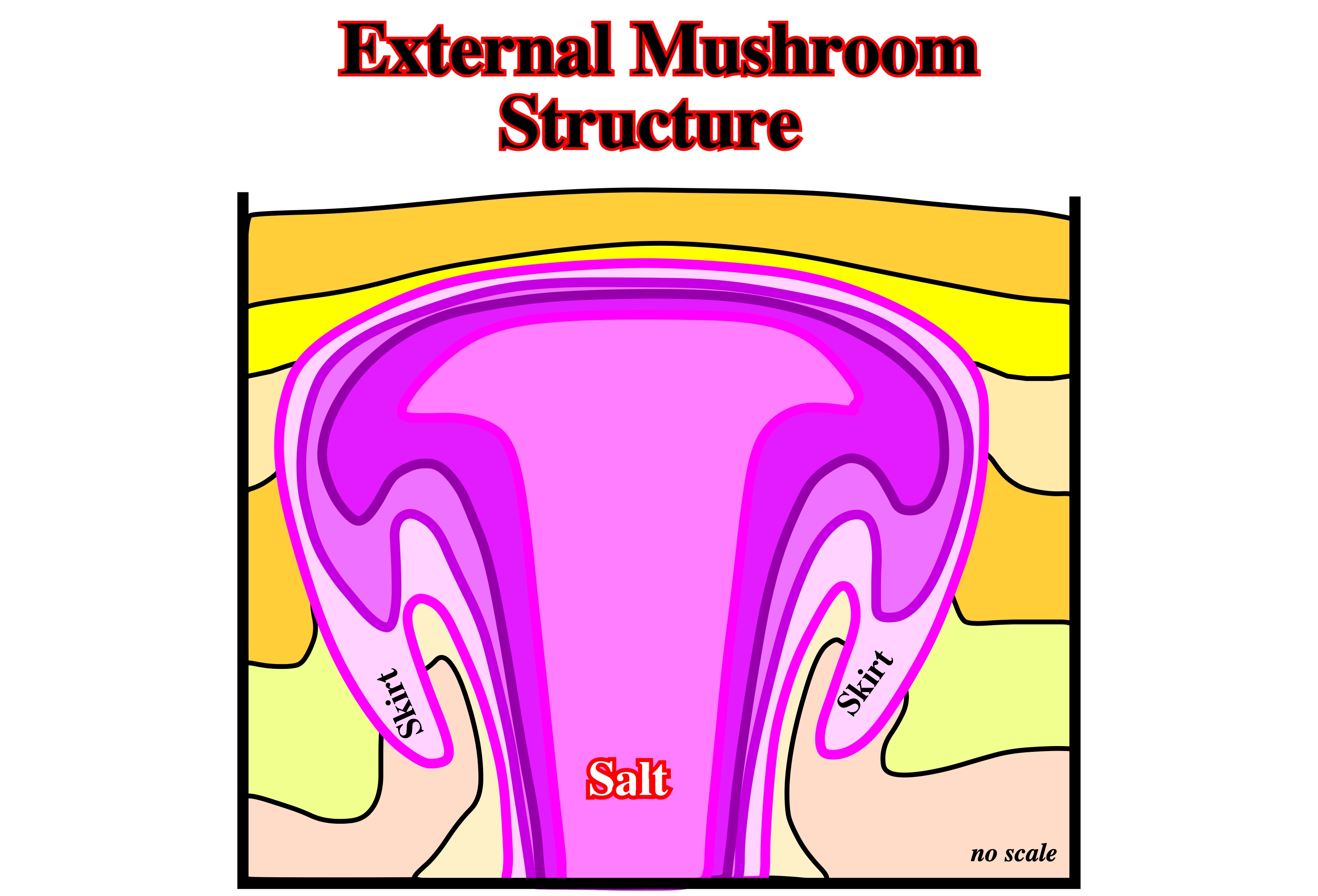
Horizontal section, taken from Jackson, M.P.A. and Talbot, C.J. (1991), through a vortex mushroom diapir showing the anticlines and infolded synclines.
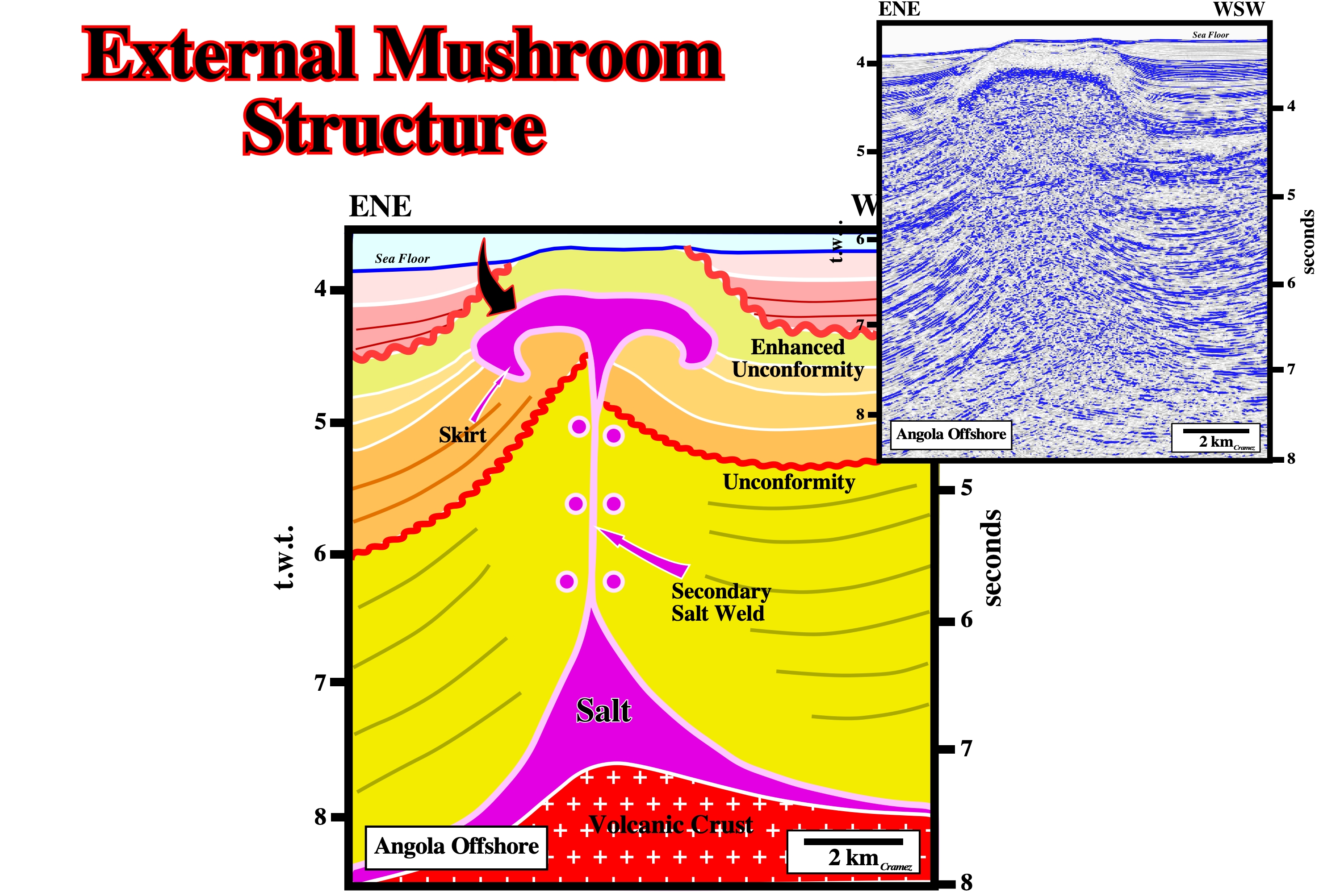
The salt structure visible on the Canvas autotrace of a detail of an Angola offshore seismic line can be interpreted as a squeezed salt mushroom. The allochthonous salt emplaced along a major fracture zone, which was, recently, reactivated in compression. The internal configuration, particularly, of the yellow interval and the onlapping of the uppermost seismic intervals strongly support the shortening and the uplift associated to the reactivation of the old fracture zone. The fracture zone seems to have played after the unconformity (in red) as a normal fault thickening the hangingwall before playing in reverse fault. The shortening of the sediments, responsible by the squeezing of the mushroom diapir was fossilized by a clearly onlapping surface (tectonically enhanced unconformity) slightly deforming the external mushroom structure.
External Shear Zone
A sheath-like collar around the crest and flanks of a diapir and formed by the rise of the diapir relative to the surrounding overburden. The inner part of the central external shear zone, typically, comprises ductile evaporites. Depending on the rheology of the overburden, the external part of this shear zone can be a ductile shear zone, a brittle shear zone, a fault, or a growth-fault.
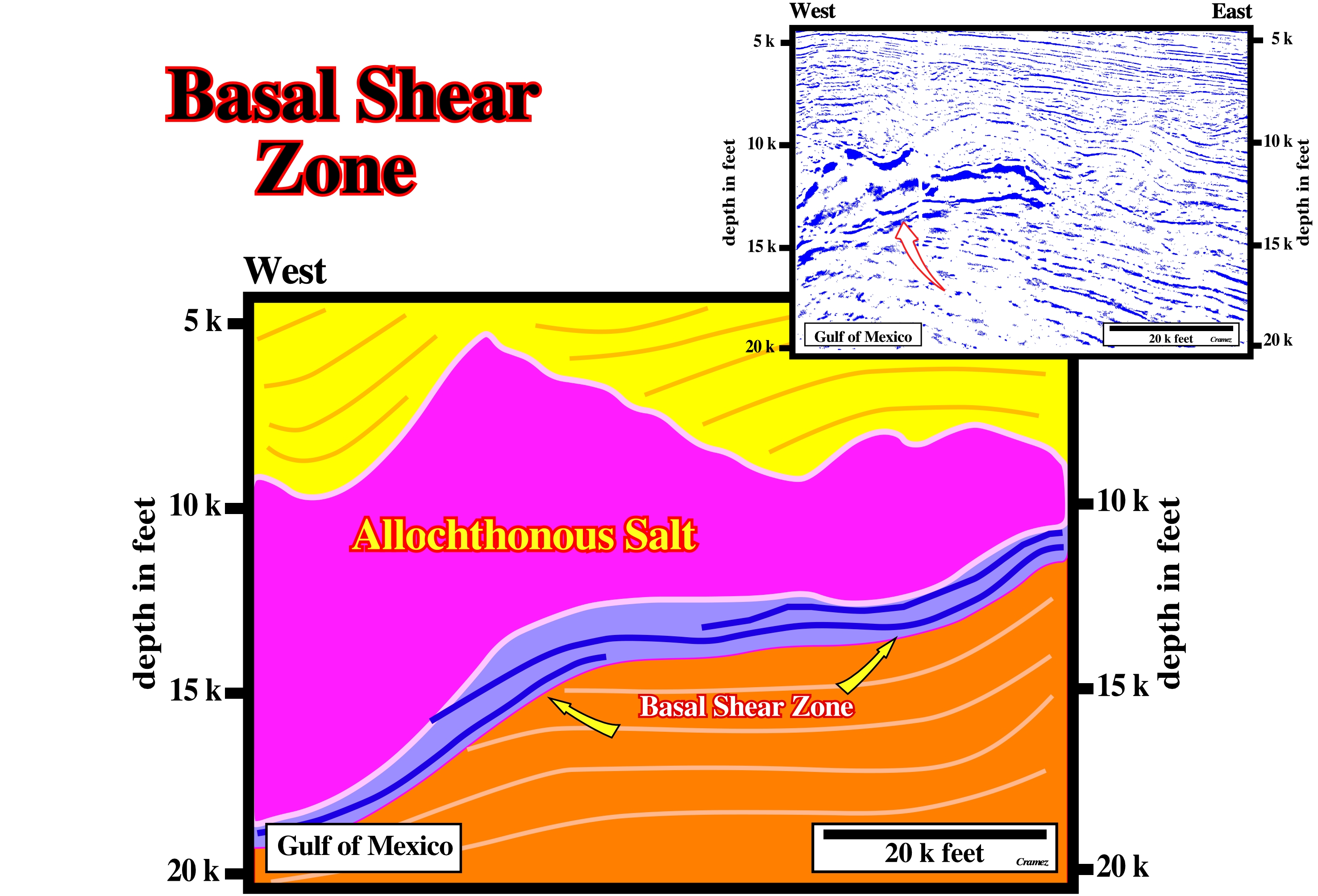
The tectonic disharmony between the sediments above and below the allochthonous salt is quite obvious. The upper sediments are much more deformed than the lower ones. In the Gulf Coast, exploration wells reaching basal shear zones found, often, an overpressured interval quite difficult to drill.
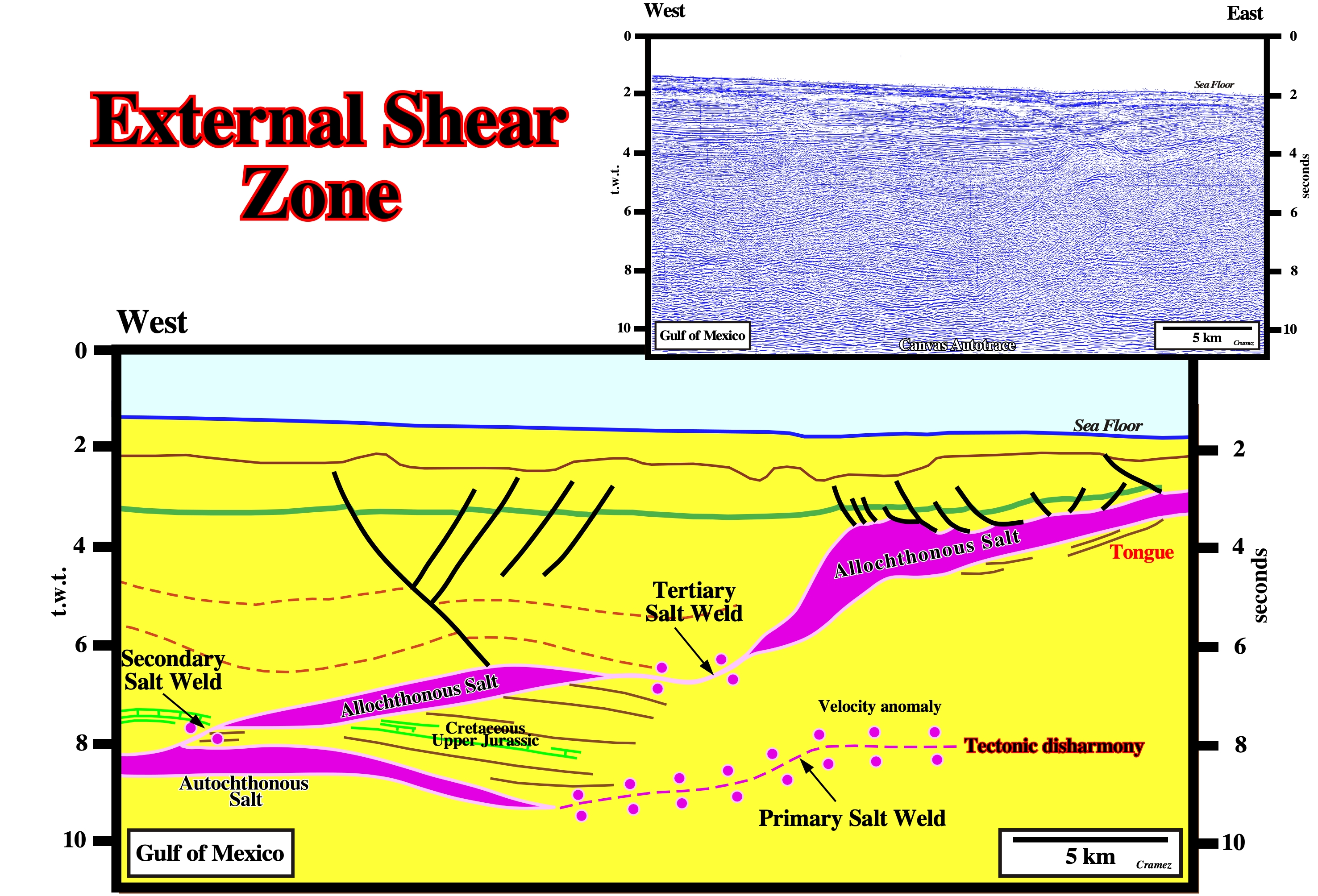
On this preliminary tentative geological interpretation of a Canvas autotrace of a Gulf of Mexico seismic line we can say the base of the allochthonous salt, as well as the tertiary salt weld, correspond to an external shear zones.
Extrusion (Salt molding)
When salt molding ratios (R°/A°) or flow rate of salt minus dissolution divided by aggradation rate of minus compaction, are in the range 100> R°/A°>10. The dip of the bottom contact flares between 0.6° and about 11.5°.
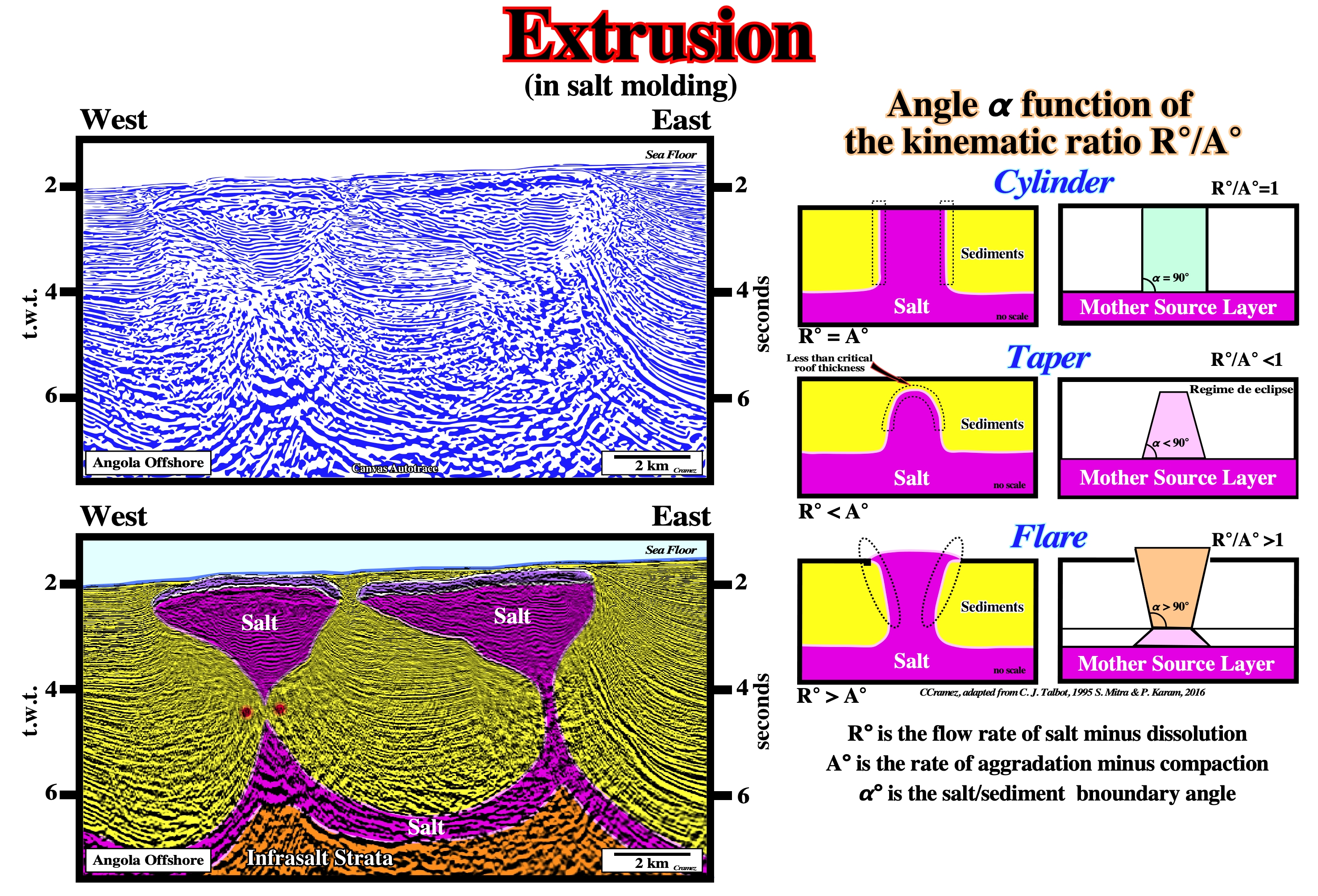
Taking into account the results of the salt molding, in which the geoscientists considered three types of the bottom contacts: (i) Cylinder, when R°/A° =1, (ii) Taper, when when R°/A°<1 and (iii) Flare, when when R°/A°>1, on the tentative geological interpretation of the Canvas autotrace of a Angola offshore seismic line , we can say there is extrusion in the formation of the illustrated salt drop structures (salt stock canopies).
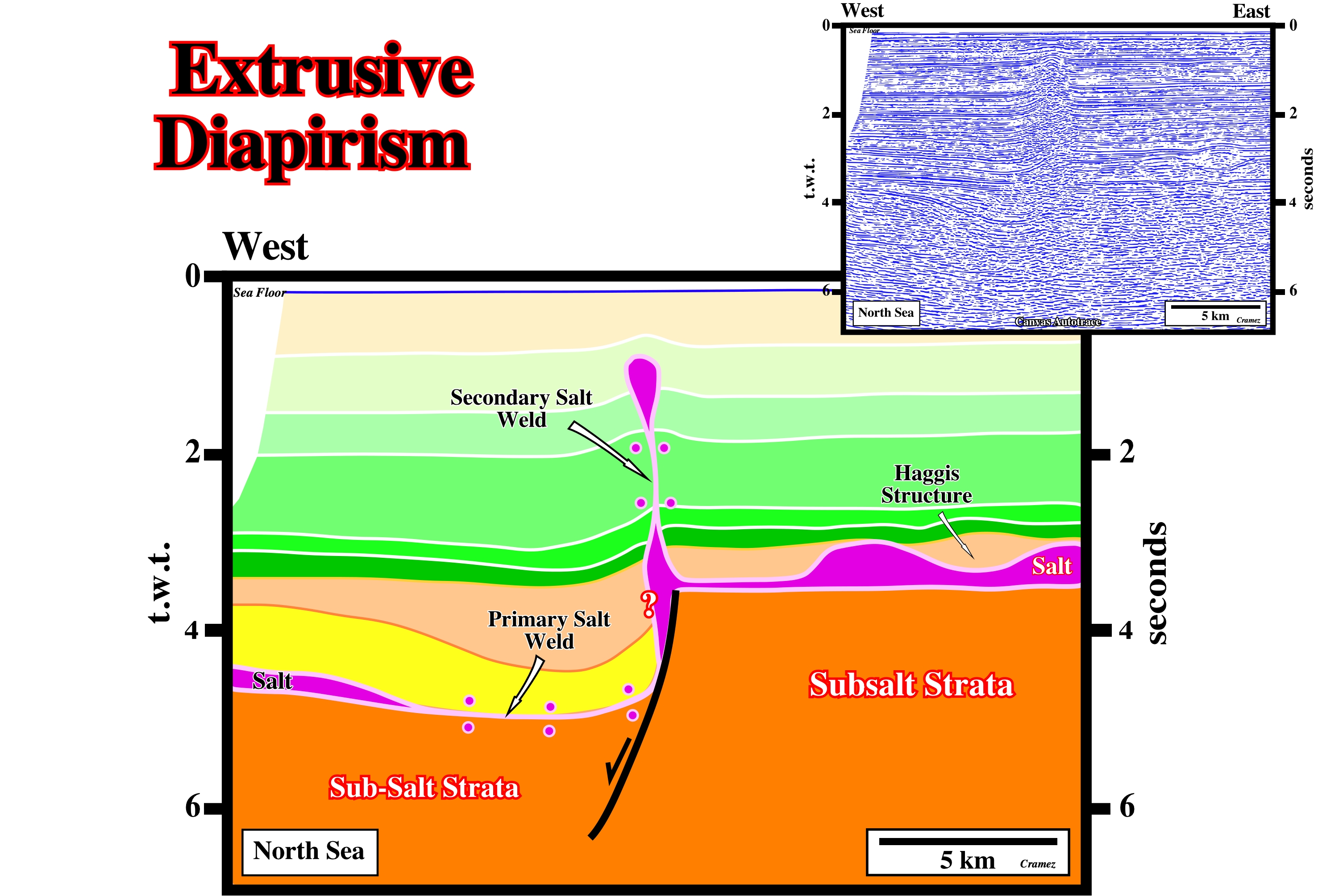
Extrusive Diapirism
Salt domes can be intrusive or extrusive. Intrusive salt domes never outcrop. They do not reach the surface. Extrusive salt domes reach the surface. They induce an apparent diapirism as sedimentation progresses. Some geoscientists considers three main evolutionary stages of a salt dome: (i) Reactive Stage, the overburden is extended (normal faulting) with small anomalies at the top of the salt can, locally, extend the overburden by normal faulting ; (ii) Active Stage, the salt flows upward and arrives at the surface (or seafloor) and (iii) Passive Stage, which creates apparent diapirism, since the salt does not deform the sediments of the overburden flowing upward as sedimentation progresses on the condition that the salt dome is connected with the mother salt layer.
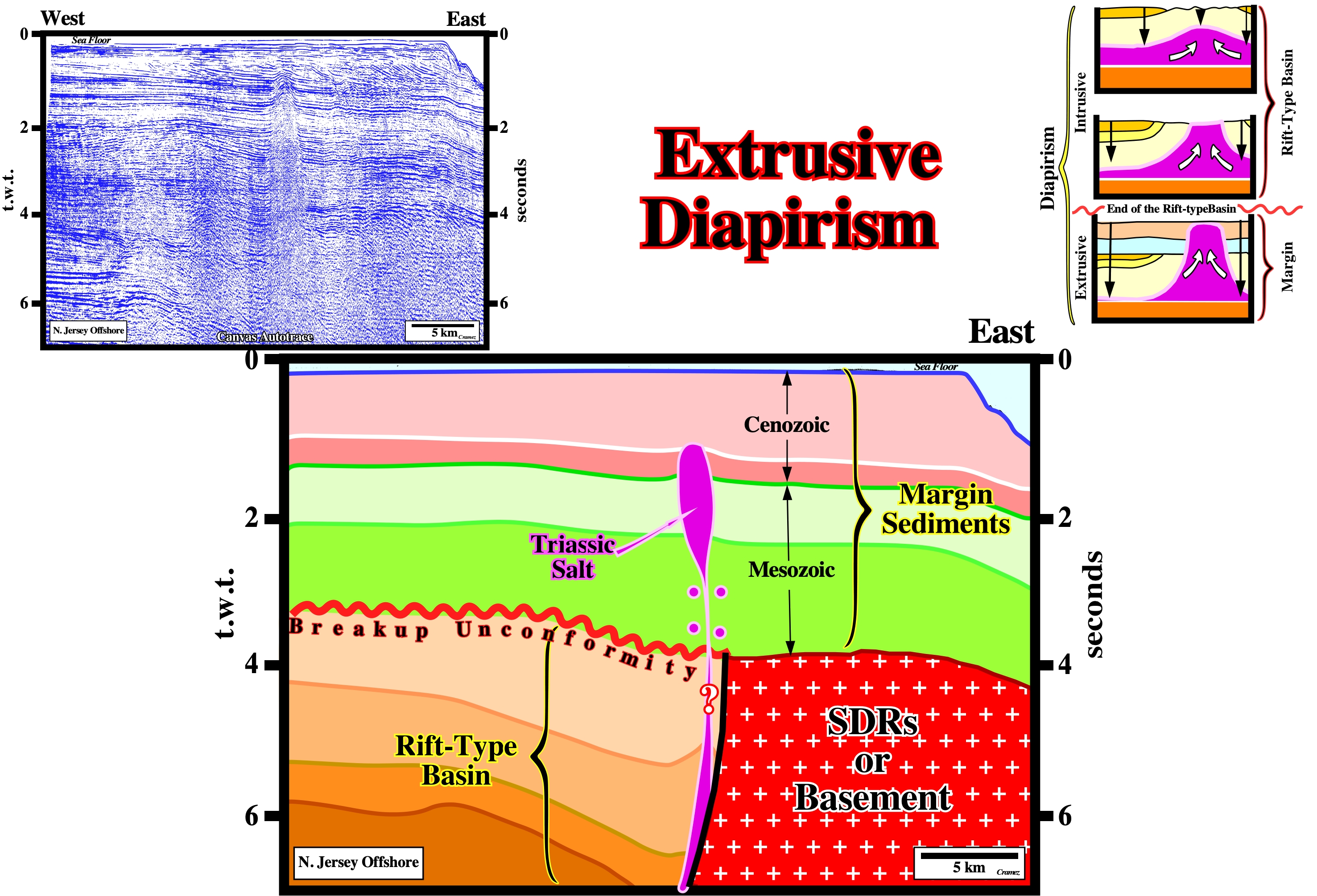
The Triassic salt dome of the rift-type basin (intrusive diapirism) reached the surface at the end of the basin filling and becomes an extrusive dome. As it was connected with the deep mother salt layer, it, progressively, grew upward as deposition progressed, without deforming the margin sediments. If the extrusive salt dome becomes disconnected from the mother salt layer (formation a vertical salt weld), generally, it ceases its upward movement.
As on the previous tentative geological interpretation, several stage of diapirism can be recognized on the evolution of the salt dome visible on this Canvas autotrace of a North Sea seismic line. Probably, by onlapping the salt layer filled the topographic anomaly (hangingwall of a normal fault) before cover, completely, the lengthened infrasalt strata. Due to the important thickness of the salt layer in the hangingwall, it starts to flow creating a compensatory subsidence responsible for the space available (shelfal accommodation) for the deposition of the sediments of the yellow intervals. The salt continued to flow (compensatory subsidence until the formation of a primary salt weld) during the deposition of the brown interval forming a depocenter (in the hangingwall) bordered eastward by an active salt dome. This active salt dome (lower green intervals) reached the surface at the end of the deposition of this interval initiating a passive stage (passive diapirism), since in its upward movement it does deform the overburden. Later the extrusive salt dome (passive diapirism) becomes disconnected of the mother salt layer creating a secondary salt weld (vertical salt weld) as the salt dome becomes a salt drop structure (detached salt stock). Finally, after a slightly upward movement the salt drop structure becomes stable (no more upward movement).