

Gabbro
A plutonic rock with quartz (Q) between 0 and 5, P / (A+P), i.e., greater than 90, (P= plagioclase; A= alkali feldspar) and plagioclase more calcic than anorthite.
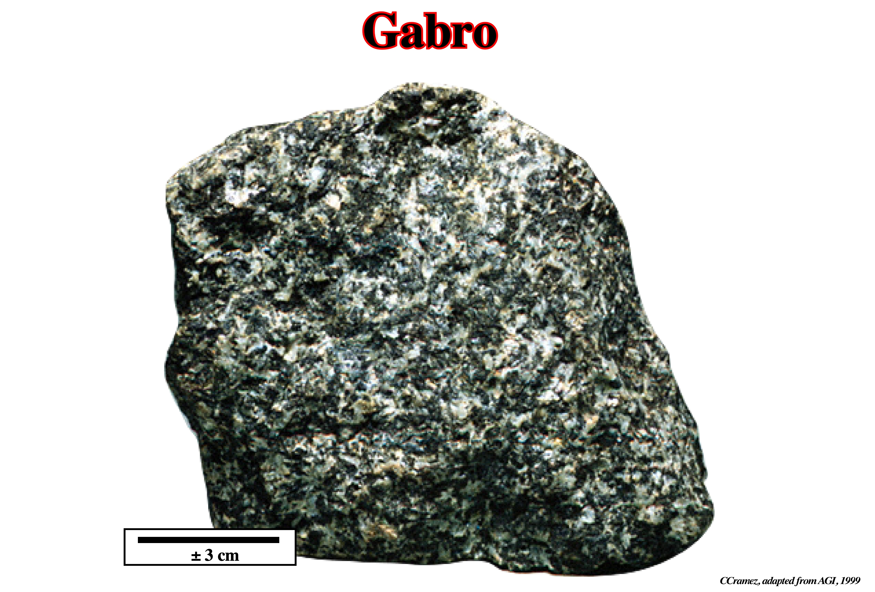
A gabbro is the approximate coarse-grained equivalent of basalt. Apatite and magnetite or ilmenite are common accessory minerals. Gabbro grades into monzonite with increasing alkali-feldspar content.
Geographic Basin
A geographic basin has no geological meaning, contrariwise to a sedimentary basin. A geographic basin is a pure administrative division of an offshore or offshore, in which sedimentary basins were deposited over time. The Kwanza geographic basin, for instance, is just the area on the Angola onshore (crossed by the Kwanza river), where along the geological time several sedimentary basins (rift type basins and a divergent margin).
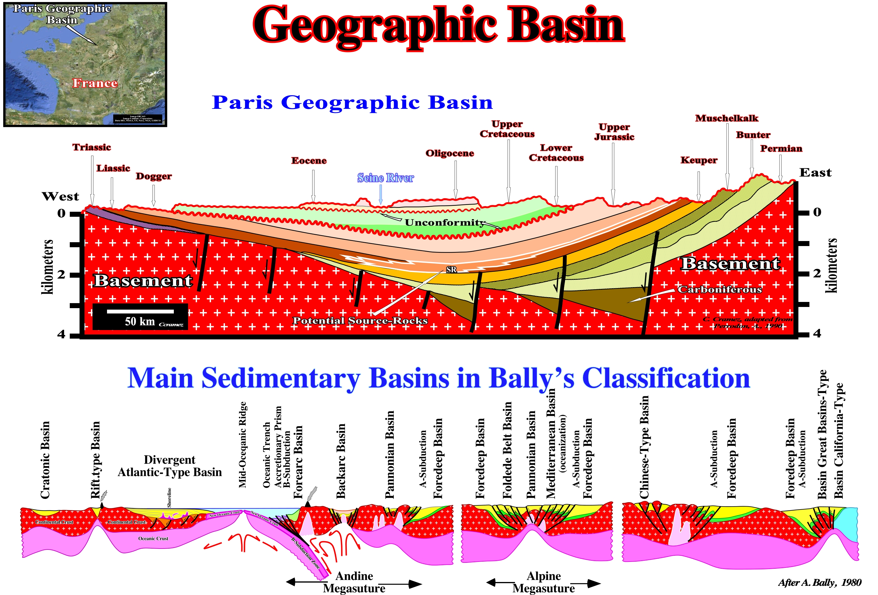
In the vast majority of cases, what many geoscientists call a structural basin is a large structural object formed by the deformation of previously subhorizontal strata. This means that the synclines are considered as structural basins. The term basin is used in its very broad sense: concave valley, wide and circular, surrounded by higher ground, to the center of which run and converge water-courses. Such a definition is not only morphologically but implies the basin is posterior to the sediments filling it (before deforming the sediments it is necessary to deposit them). In geology, this does not seem to be very correct. The term basin designates the place where the sediments are deposited and not the place where and how they were deformed. The geological section illustrated in this figure shows, roughly, the structural and stratigraphic configuration of what is often termed the "Paris Basin". Taking into account the definition of a sedimentary basin: low ground crust area, with a variable geometry, almost circular to linear, usually of tectonic origin and in which sediments can be deposited which always thicken to the deepest and central part which is the most subsiding, it is evident this geological section, strongly, suggests the "Paris Basin" is a deformed continental shelf and not a sedimentary basin. It was raised at east and at west. It is this type of structure is, often, called structural basin, by certain geoscientists call. However, this designation, i.e., a structural basin just makes sense if the deformation is synchronous with the deposition. If the deformation is posterior to the deposition, as seems to be the case in the Paris basin, the structural specification is poorly applied. That is why in this figure the structural specification is enclosed in quotation marks. A sedimentary basin is a structure in extension (lengthening) with a synform geometry (fold in whose nucleus the rocks are more recent than the surrounding layers). Its geometry is, more or less, circular, with the layers diving and thickening, slightly, to the center, which does not correspond to what is observed on the above geological section. In this figure, with the exception of Carboniferous halfgrabens*, which are the rift-type basins on which a Mesozoic divergent margin has been deposited, the thickness of the stratigraphic intervals is, practically, constant (although there are several tectonically enhanced unconformities, i.e., several angular unconformities). The sediments dip towards the center of the structure but they do not thicken (regionally erosion is, certainly, not very important). The synform geometry is posterior to the deposition. Probably the sediments were deposited in a platform or in an abyssal plain environment. The internal configuration of the sedimentary intervals is parallel** (subhorizontal at the depositional time). Observation data refute the second hypothesis (abyssal plain environment). The petroleum generating subsystem (Lias source-rocks) is located, mainly, in the Central and East area of this section. According to several geoscientists, the evolution of the organic matter of these potential source-rocks is dependent on the erosion associated with the Late Cretaceous and Tertiary unconformities, i.e., with the burial of the source-rocks. This implies that before the erosion, which produced the unconformities, the organic matter of the source-rocks had already reached maturity. At my knowledge, this hypothesis has not been tested. The geometric relations observed on the seismic lines, which are, more or less, summarized in this geological section suggest more a refutation than a corroboration of such hypothesis. Similarly, when a geoscientist speaks of the Neuquen Basin (onshore Argentina) or the Kwanza Basin (onshore and offshore Angola), he is not talking about sedimentary basins, but geographic basins that correspond, in geological terms, to the spatial and temporal stacking of different types of the Bally and Snelson's basin classification , which is adopt in this glossary.
(*) Lengthening structures, induced by a differential subsidence, and formed by normal, more or less, parallel faults, in which the dip of the fault plane is, roughly, in the same direction, that is, faults with the same vergence or slope.
(**) Obviously, when the internal configuration of a sedimentary or seismic interval is parallel, two things are possible: (i) The coeval dipping beds (continental or delta slope, function of the scale) are downstream, and in this case the subhorizontal intervals are, probably, platform deposits or (ii) The coeval dipping beds are upstream and in this case the subhorizontal intervals are, probably, deep-water deposits.
Geoid
The figure of the Earth considered as the sea level surface extended continuously through the continent. It is a theoretically continuous surface perpendicular at every point to the direction of gravity. The geoid is the equipotential surface of the Earth's gravity field.
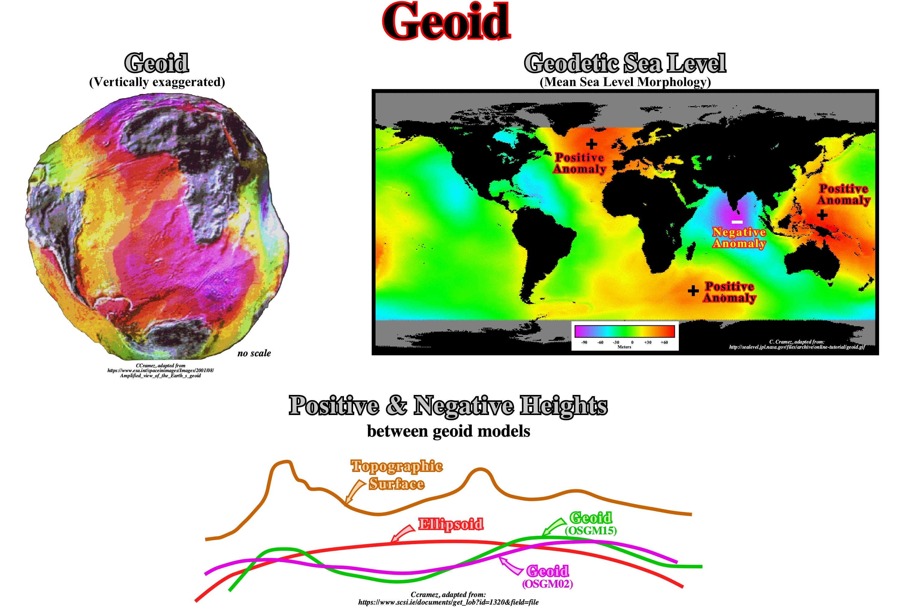
The morphology of the Earth’s topographic surface (based on GPS, i.e., Global Positioning System) ranges from +8,848 meters (Mount Everest to −11,034 meters a Marianas Trench). The geoid’s deviation from an ellipsoid ranges from +85 m (Iceland) to −106 m (southern India). All representation of the geoid (more or less the mean sea level), as the one illustrated above (GOCE, i.e., Gravity Field and Steady-State Ocean Circulation Mission) is, highly, vertical exaggerated (> 1000 scale factor). The differences between OSGM02 and OSGM15 can be, largely, attributed to improvements of the gravity data (additional gravity data from GRACE – Gravity Recovery And Climate Experiment – satellite mission) and fitting of the OSGM geoid model. Much of the available orthometric height data in the extreme west of Ireland is of a lower standard, having been derived from a transformation datum rather than leveling. These effects combine to produce significant deviations between current and previous models. Sea level profiles show strong irregularities. Sea level is not flat. Large humps and depressions, related with gravity changes which in fact control them, are quite evident. Between the highest, near New Guinea, and the lowest, near Maldives, there is a difference around 180 m. The present geoid configuration is, of course, not stable. Eustatic sea level changes must take into account local sea level variation induced by gravity anomalies. The ocean level, i.e. the geological eustatic level assumed to be parallel to the Earth's ellipsoid, but via gravity irregularities, changed to the rough and uneven geodetic sea level, or equipotential surface of the geoid.
Geologic Map (McNeill, L. et al., 1999)
A map on which is recorded geological information, such as the distribution, nature and age relationships of rock units and the occurrence of structural features (folds, faults, joints), mineral deposits and fossil localities.
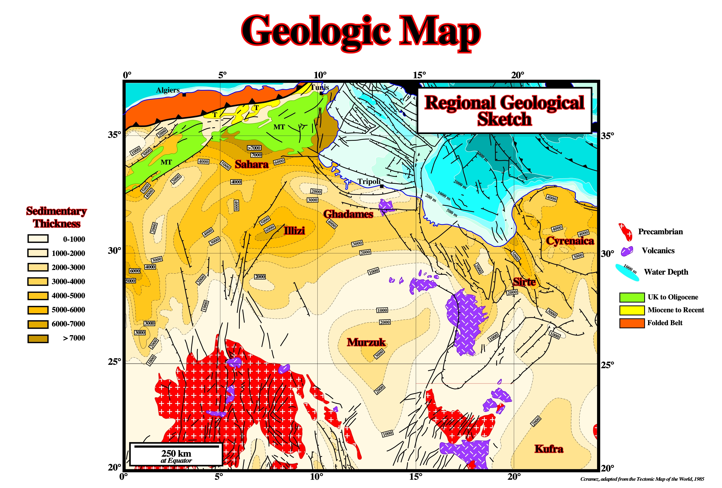
A geologic map indicates geologic structures by means of formational outcrop patterns, by conventional symbols giving the direction and amount of dip at certain points or by structure contours lines.
Geologic Ma (Geological age)
See: Ma.
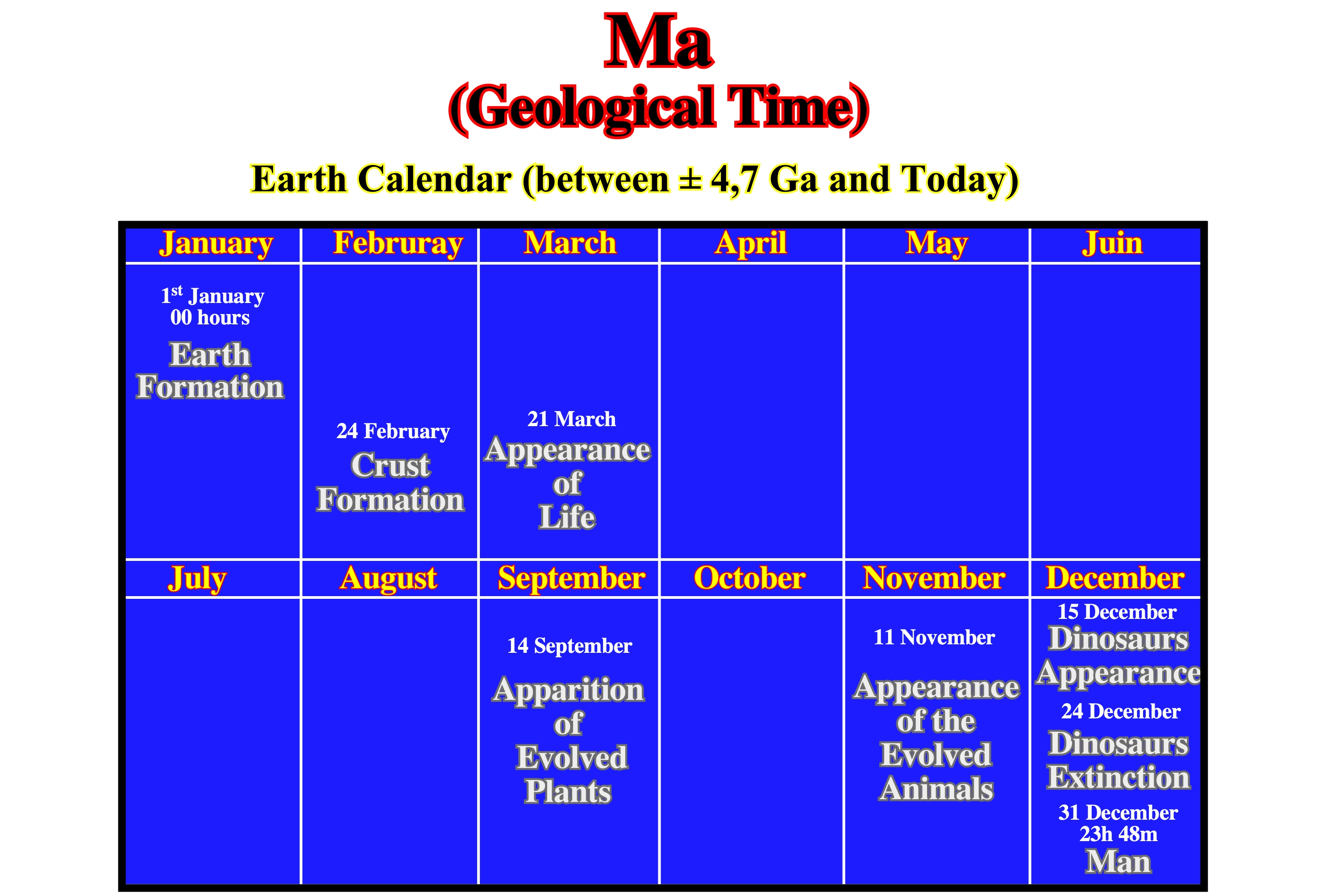
Ma means geological time, i.e., million years ago, while My means, just, million years, i.e., a certain amount of time. Conceiving time in an abstract and intellectual way is simple. Everyone knows how many zeros must be added to the number 10 to represent billions of years. However, the notion of Geological Time is so strange that we can, only, apprehend it through metaphors. One of the well-known metaphors is the Earth's calendar, which allows us to see the temporal evolution of major geological events throughout Earth's history. In this metaphor, which is illustrated above, it is assumed that the Earth's age is 1 year. It would have been formed, for instance, on 1st January at 00 hours and 00 minutes. Today, it is midnight on 31st of December. In this calendar, the Earth crust would have been formed on 24th of February. Life appeared on 21st of March. The evolved plants appeared on 14th of September. The evolved animals appeared on 11th of November. The appearance of the dinosaurs would have been on 15th of December and their extinction on 24th of December. The man appeared on 31st of December at 23 hours and 48 minutes, which means that mankind is 12 minute old. The same kind of metaphor can be made for a calendar of the Universe. If the age of the Universe corresponds to one year: a) the Big Bang occurred on 1st of January 2019, for instance ; 2) Galaxies would have been formed on 3rd of January ; 3) Sun on 1st of August ; 4) Planets on 21st of August ; 5) Life appearance on 17th of September ; 5) Vertebrates appearance on 15th of December. The Man would have appeared around midnight on 31st of December. In McPhee's metaphor: "if a simple filing on the nail of the middle finger makes Humanity disappear: (i) The length of the finger corresponds, practically, to the Phanerozoic ; (ii) A part of the hand and arm correspond to the Cryptozoic (time interval between ± 540 Ma and 4700 Ma, i.e.., the set of Proterozoic, Archean and Hadean), during which the main geological events are spaced in time as in the calendars of the Universe and Earth. Human insignificance is very well translated by Mark Twain in his famous metaphor of the Eiffel Tower: "Man has been here for thirty-two thousand years. That it has taken hundreds of millions of years to prepare the world for it is proof that the world was made for it. I think, I do not know. If we now take the Eiffel Tower to represent the age of the world, the painting film on the top that covers the pinnacle would represent the age of humanity and it is evident to everyone that the tower was not built for that thin film of paint; if you want, I do not know". In Earth's history, geological and biological events are calibrated in sagittal time (arrow) and it is the synergistic result of unidirectional, cyclic, punctual and chaotic events in a world where non-linear processes are frequent and where order alternates with chaos (disorder). The identification of such events is one of the main functions of geoscientists, who must separate events with a global significance of local events and determine the geometric and chronological relations between them and the driving forces that give rise to them.
Geostatic Pressure
The weight of a column of beds. At a given depth, the geostatic stress or geostatic pressure (σg) is given by a biaxial ellipsoid, with: σ vertical =σ v = δ. g .h (δ =density of sediment, g = gravitation, h = height of sediments) and σ horizontal = σ h = confining pressure of σ g . The geostatic stress ellipsoid varies with depth. The state of stress tends to become hydrostatic at great depth.
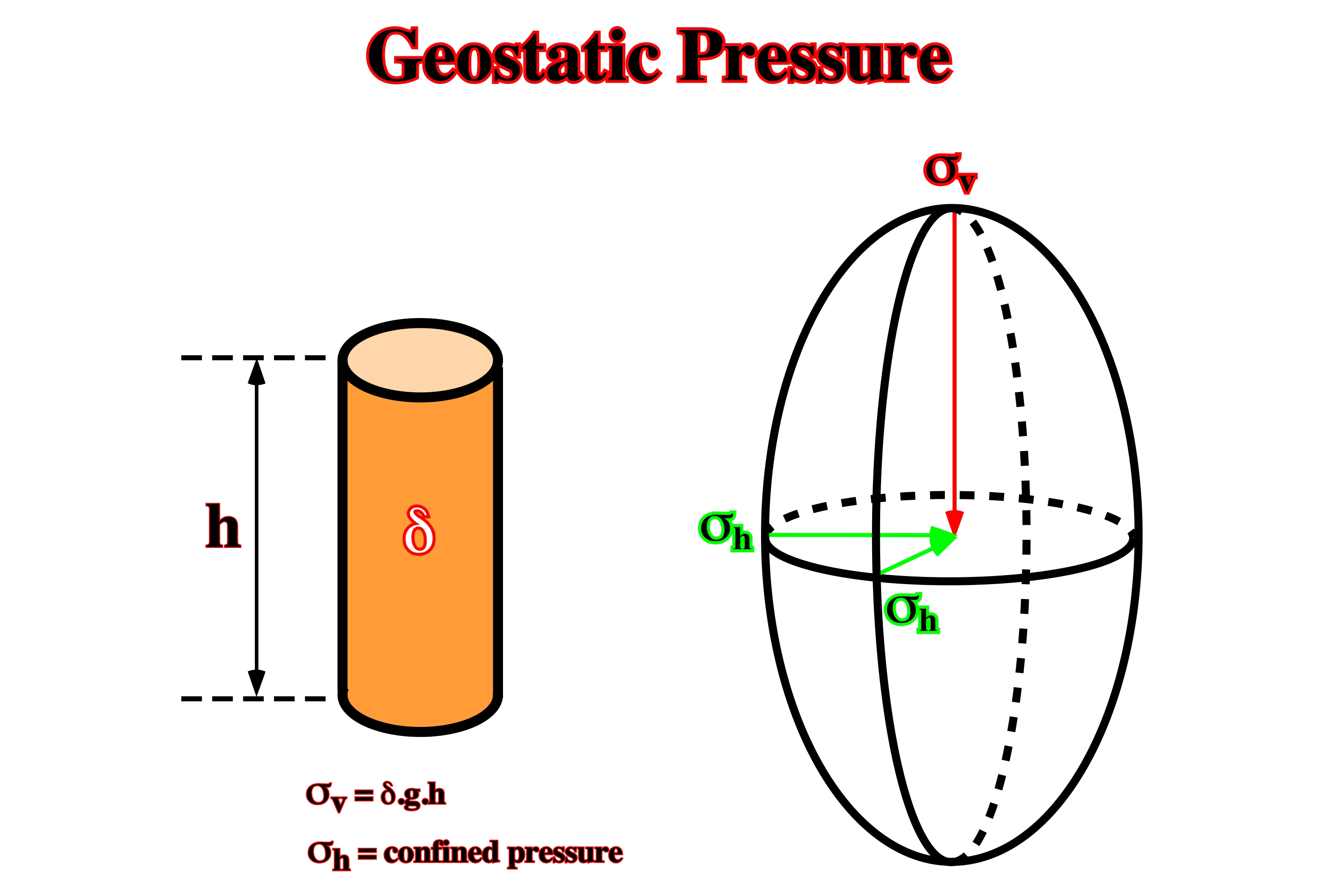
One of the consequence of the increasing, in depth, of the geostatic or lithostatic pressure is that its ellipsoid tends to become uniaxial, therefore, theoretically speaking, it is evident that the dip of the fault planes of normal and reverse faults becomes smaller in depth, i.e., fault planes flat in depth.
Glacial Flow (Jackson, M. P. A. and Talbot, C. J.,1991)
Flowing downdip from an exposed structure and spreading beneath air or water as in a glacier.

A glacier can be defined as a large mass of ice formed, at least in part, on land by compaction and recrystallization of snow, moving slowly by creep down-slope or outward in all direction due to the stress of its own weight, and surviving from year to year. Namakiers, i.e., salt glaciers flow down-slope in a similar way.
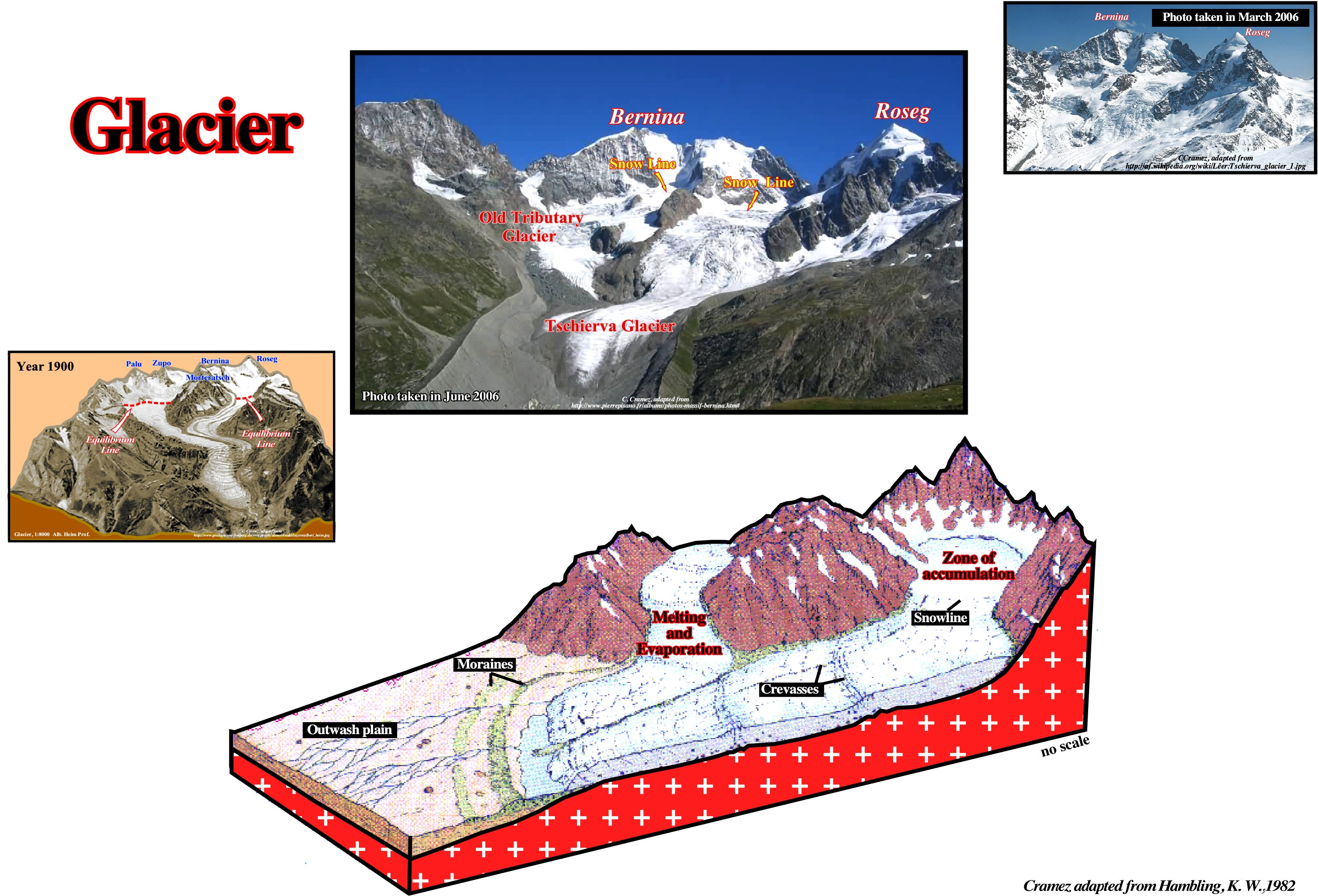
In the upper part of a glacier, three zones can be distinguished: (a) Accumulation, (b) Melting and (c) Evaporation. In the lower part, different king of ice structures can be recognized: (i) Snowlines ; (ii) Crevasses ; (iii) Moraines and (iv) the outwash plain.
Glacial Structures (Salt) (J ackson, M. P. A. and Talbot, C. J.,1991)
Structures, which are not unique to salt glaciers, that provide an unrivalled display of progressive strain in salt (see below).
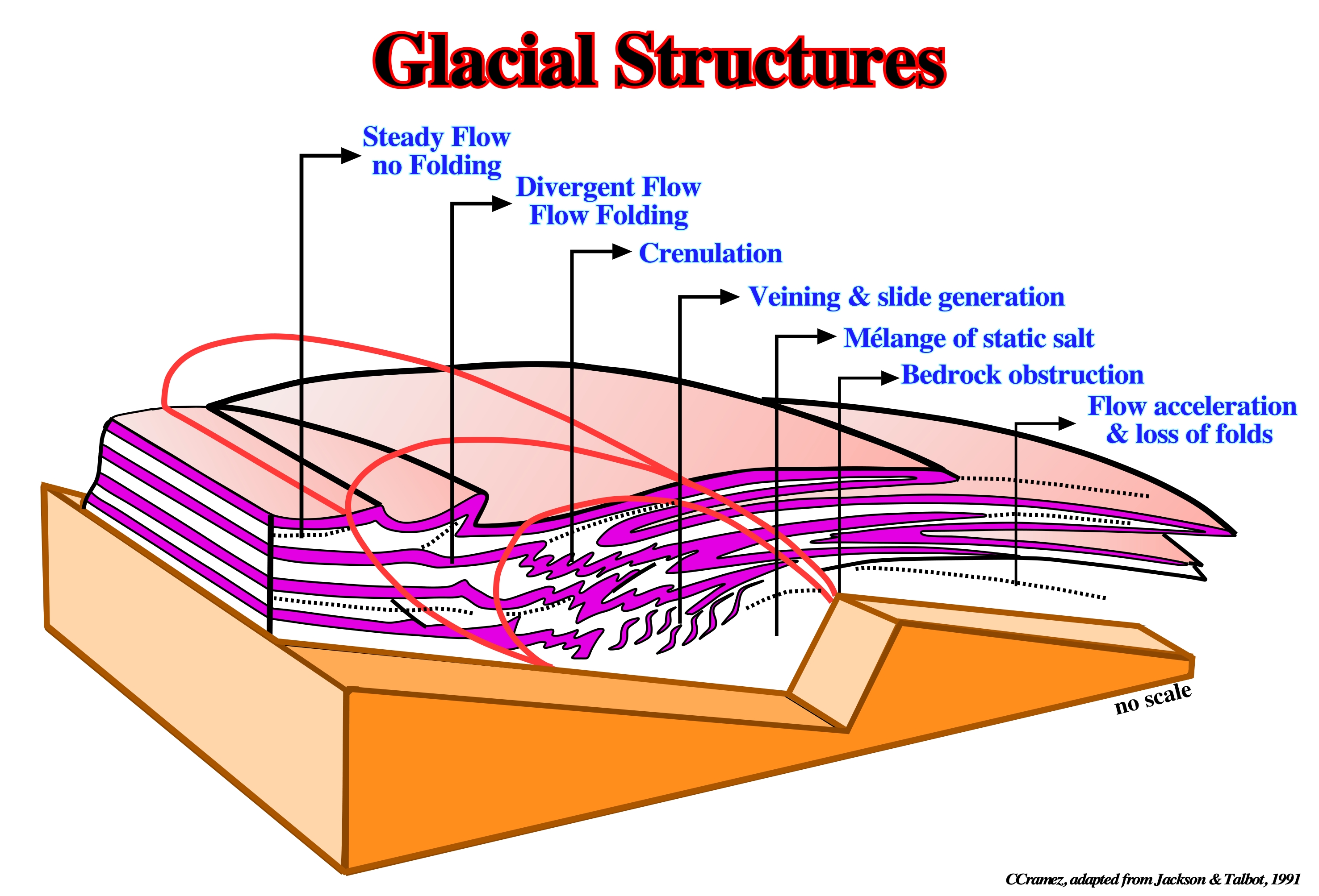
Block diagram showing schematic development of folds, sheath-folds, as slides (sheared-out limbs) in glacial salt flowing from left to right across a bedrock step. Where flow decelerates upstream of step, streamlines (dashed lines) diverge and deflect layering in the salt to form flow-folds on left. Flow then accelerates above the step and the streamlines converged, thereby tightening and elongating folds into sheath-folds (large recumbent folds on the right).
Glacier (Salt)
See: Salt glacier or Namakier.
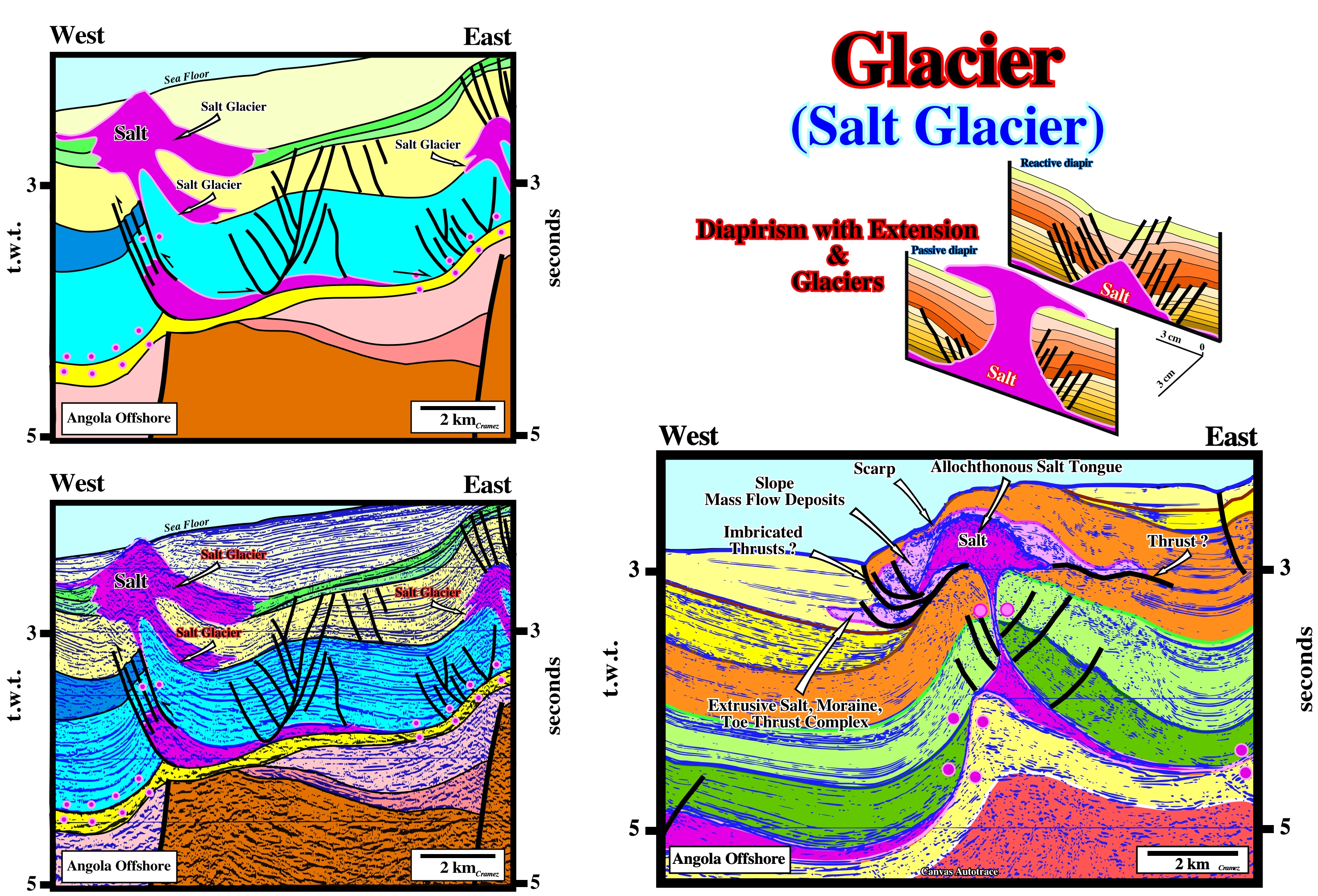
As illustrated on these tentative geological interpretations of Canvas autotraces of the Angola offshore, a salt glacier is a gravity flow (similar to that of an ice glacier) of evaporites associated with a passive diapir (rising diapir) when the salt reaches the surface, i.e., when the salt outcrops. The downdip movement of a salt glacier can be of few meters per year. When erosion and sedimentation are not significant, the movement of salt continues long time. If the sedimentation rate increases,they are quickly fossilized as illustrated on these tentative interpretations.
Goguel's Law (Goguel, J., 1965)
The Second Law of Thermodynamic when applied in Geology. The Goguel's law can be summarized as follows: "Throughout deformation, volume is conserved, but for that due to a loose porosity or dissolution".
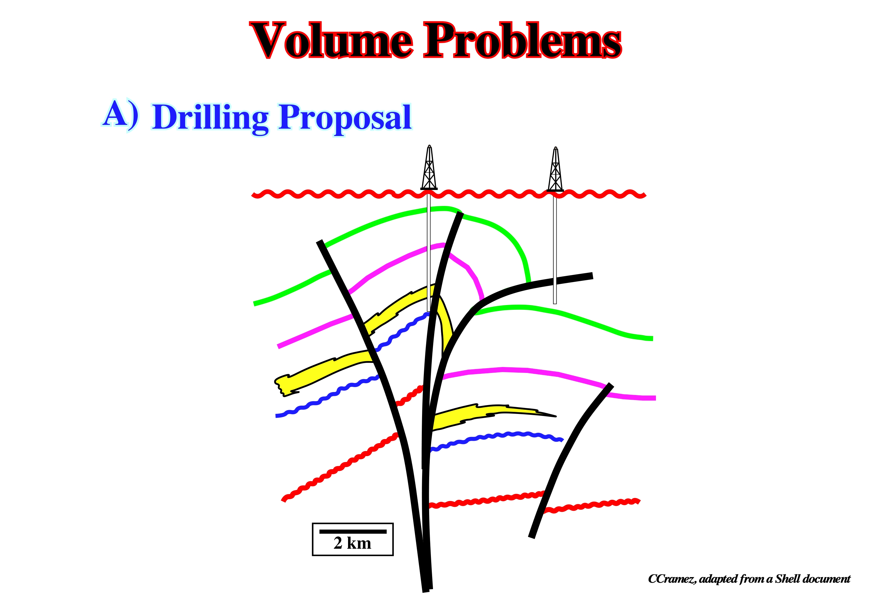
This sketch represent a geologic interpretation of a seismic line shot in an area where strike slip movements are absent. If that is so, the seismic interpreter did not respect the Goguel's law, since, in this interpretation there is a major volume problem (see below).
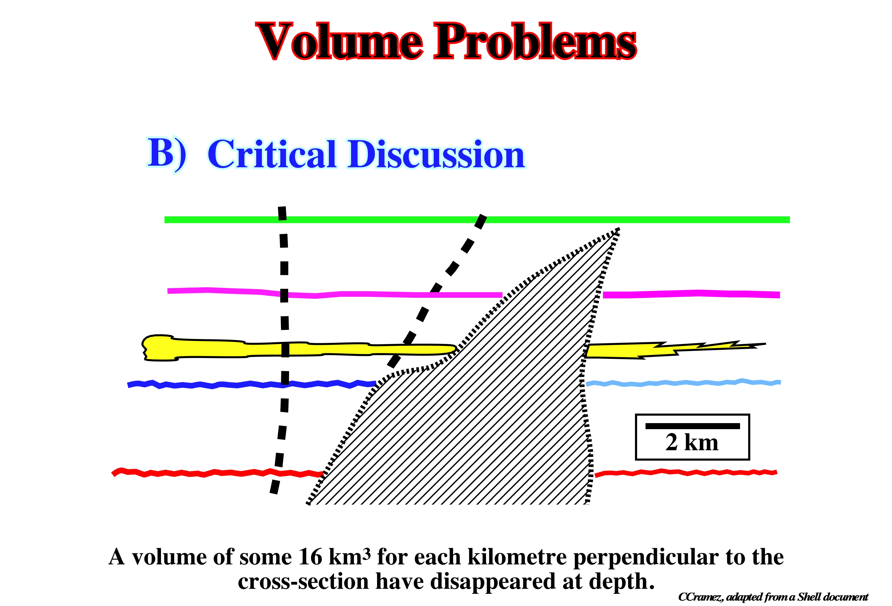
A critical discussion of the above geological interpretation clear indicates the interpreter did not respect the Goguel's law. Such interpretation puts away a so large volume of sediments that the interpretation becomes unlikely.
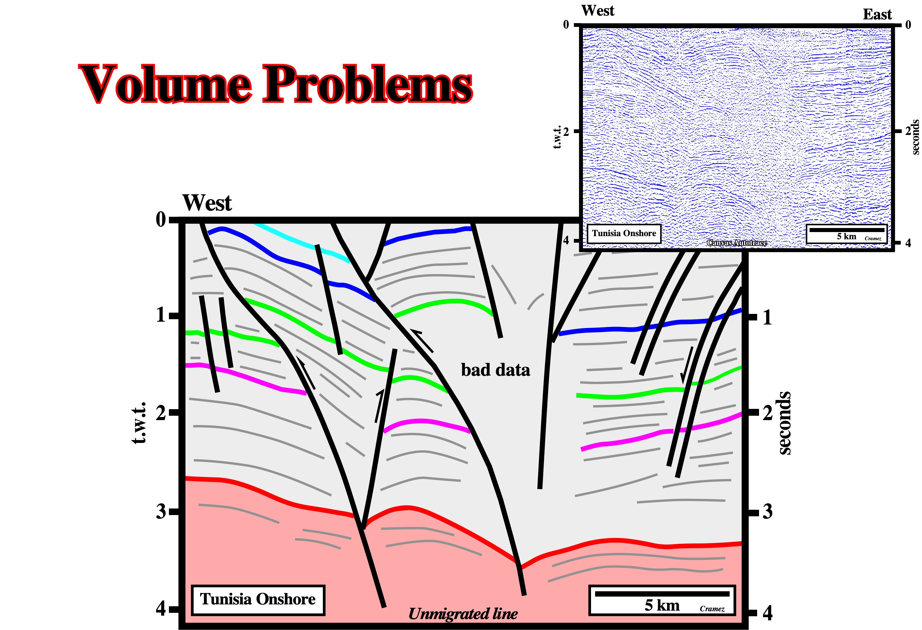
It is quite obvious that this tentative geological interpretation of a Tunisia onshore seismic line, coming from an area in which there is not strike-slip displacement, does not respect the Goguel's law. If you assess the shortenings of the red and green horizons, you realize, immediately, that detachment surfaces between them are unavoidable.
Graben
An elongate trough or basin, bounded on both sides by high-angle normal faults that dip toward the interior of the through.
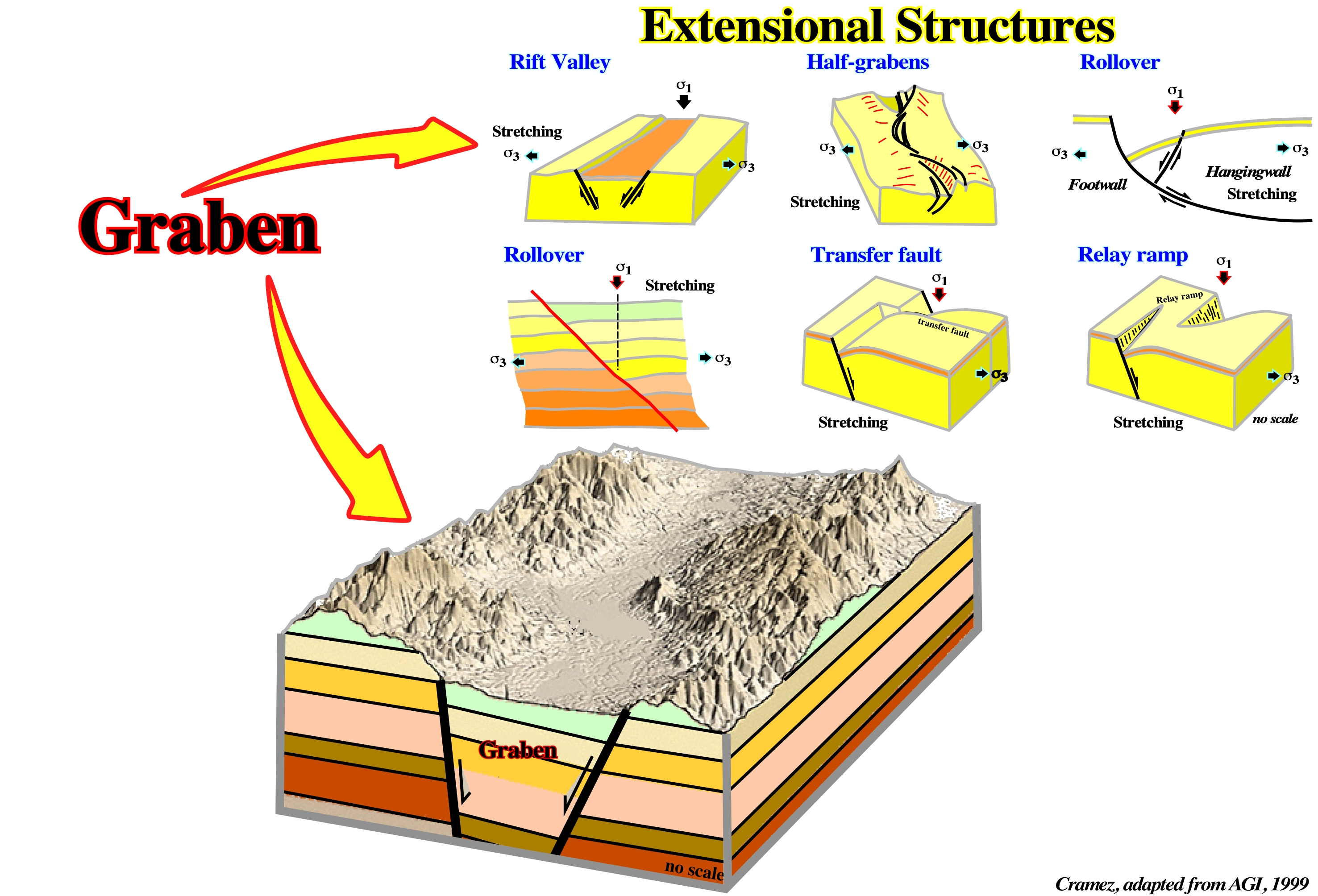
All rift-type basin are grabens, but not all grabens are rift-type basins. Generally, grabens are not symmetric. Very often, they correspond to two halfgrabens of different age.
Graben Type Diapirs (Ruig, M. J., 1995)
Based on their external shape and boundary faults diapirs, extension-induced diapir have been subdivided, for descriptive purposes, into three types: (i) graben, (ii) pull-apart and (iii) fault injection. In graben type diapirs, the boundary faults are, commonly, associated with small evaporites. and the larger diapiric outcrops are in the center of the grabens. In certains areas, a later compressional tectonic regime reactived, often, these extensional salt structure by shortening.
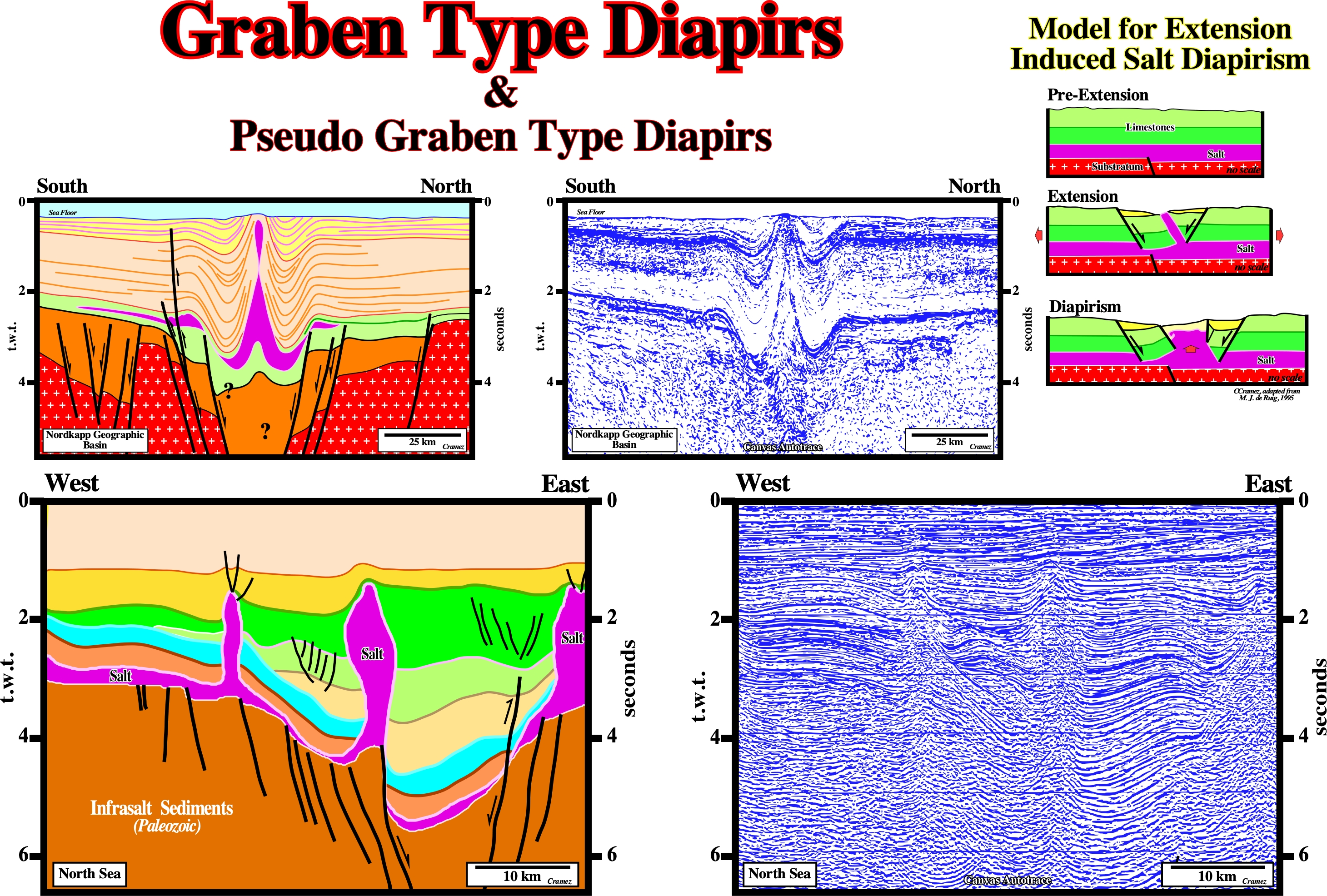
As illustrated in the model for extension induced by diapirism of M. J. Ruig, le term graben type diapir is used just when the diapirism is created by the opening of normal fault zone, i.e., by the upward salt movement infilling the space created by lenghtening of the overburden. Obviously, the diapirism observed on the tentative geological interpreations of the above Canvas autotraces (North Sea and Nordkapp seismic lines), do not correspond to the Ruig's definition, in spite of the fact that, in both cases, the salt, at time of deposition, filled a graben structure.
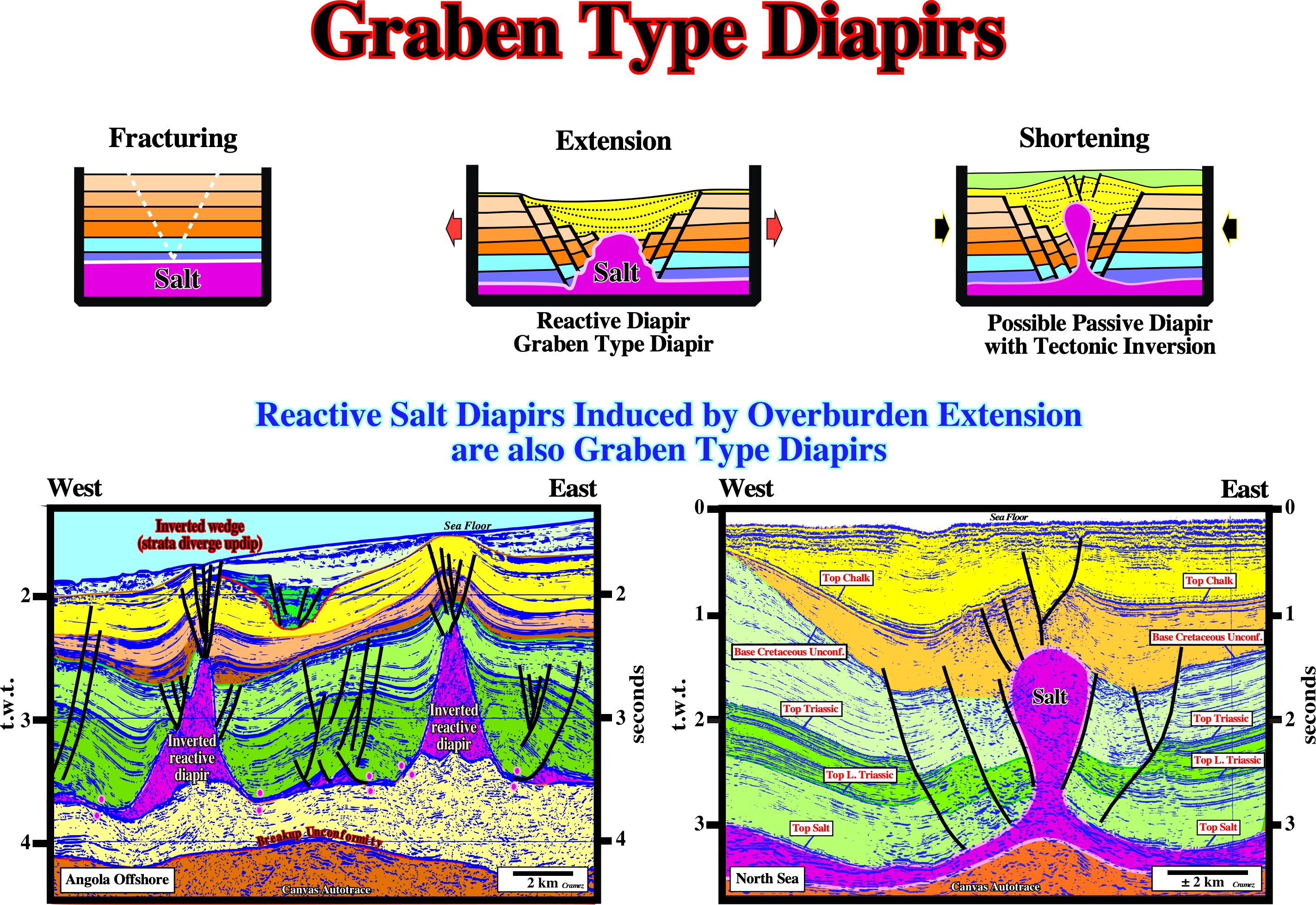
As illustrated here above, reactive diapirs induced by a lengthening of the overburden, can, if we want, to be considered as graben type diapirs (in the sense of Ruig) since there is only one way to lengthen the sediments, i.e., by normal faulting. The same is true in salt induced tectonic inversions, in which the strata of the central area of the depocenters diverge updip, i.e., the initially low structural points become high structural points.
Granddaughter Diapir
A third generation salt wall or stock flanking a daughter diapir.
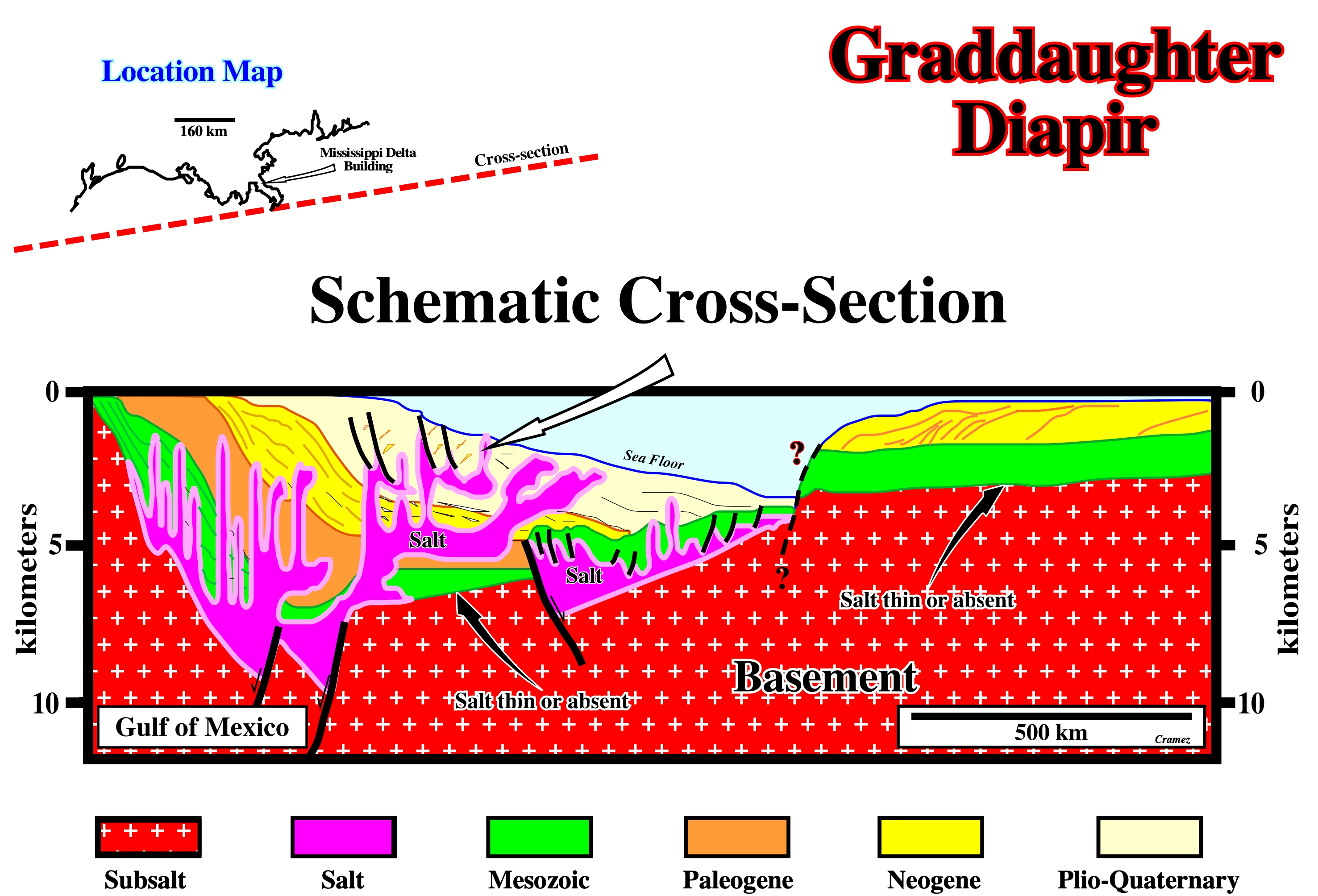
Granddaughter diapirs are known in the Gulf of Mexico. As illustrated above, they rise from secondary order allochthonous salt sheets.
Granite
A plutonic rock with quartz (Q) between 20 and 60 and P/(A+P) between 10 and 65 (IUGS classification, where P = plagioclase and A= alkali feldspar) or a plutonic rock, in which quartz constitutes 10 to 50 % of the felsic components and in which the alkali feldspar /total feldspar ratio is generally restricted to the range of 65 to 90 %.
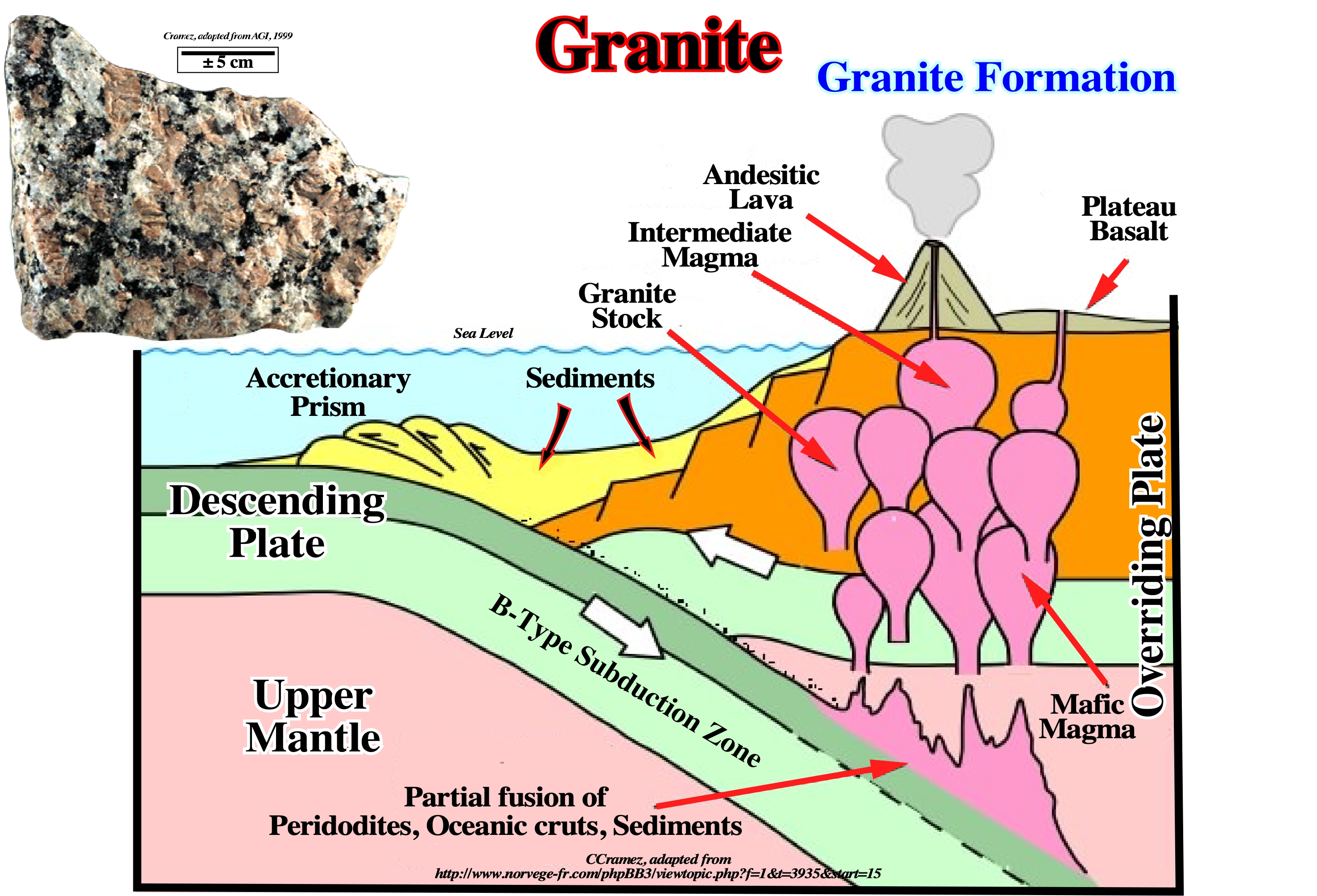
Rocks in this range of composition, indicated above, are scarce, and sentiment has been growing to expand the definition to include rocks designated as adamellite or quartz monzonite, which are abundant in the U.S. Another broadly applied definition of granite is any holocrystaline, quartz-bearing plutonic rock.
Granitic Rocks
Those pertaining to or composed of granite.
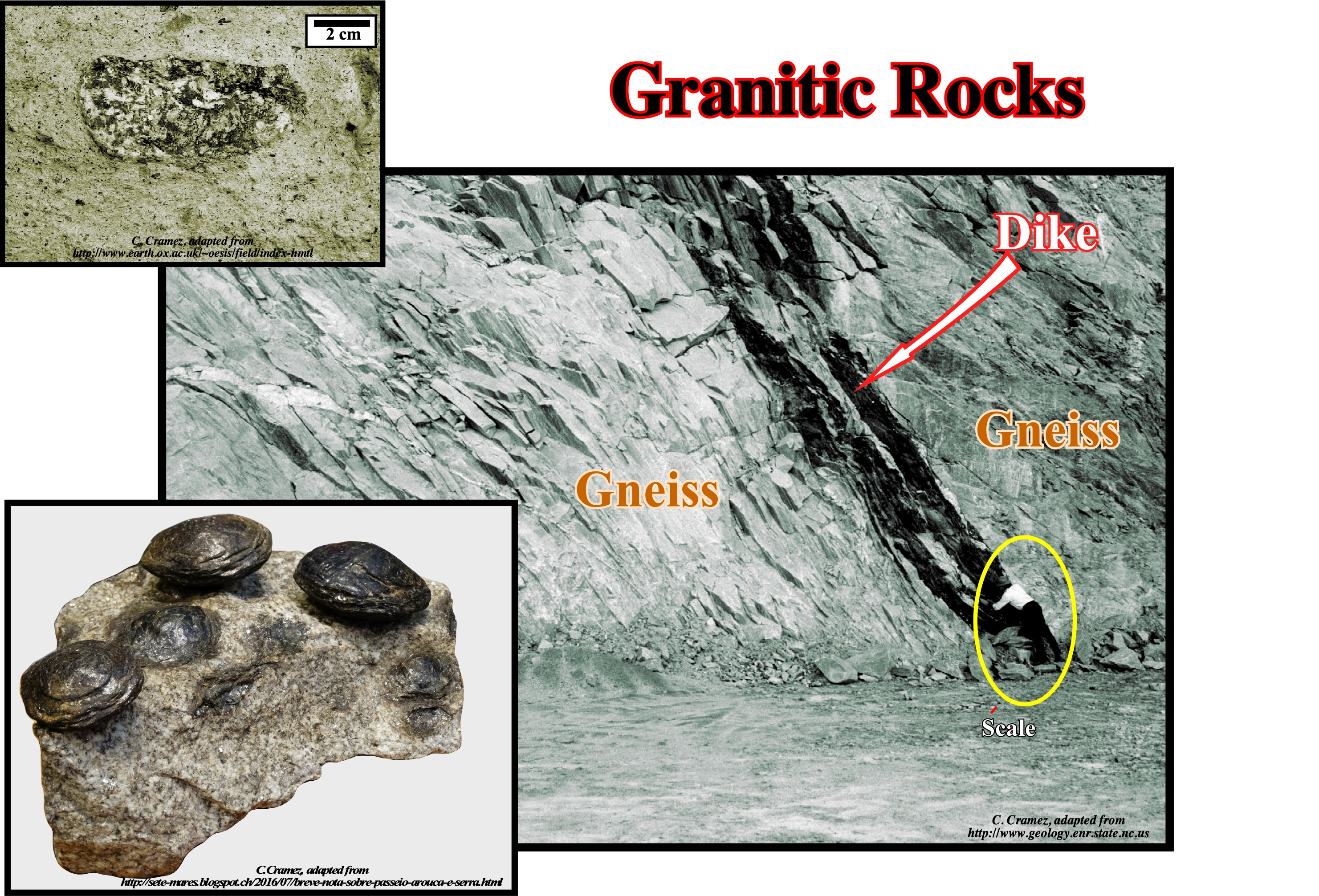
Granitic rocks such as quartz monzonite, granodiorite, quartz diorite, monzonite, etc., are mineralogically similar to granites. These granitic rocks, collectively, make up the large batholiths of the world, and many of the smaller stocks, laccoliths, dikes, and sills. They are by far the most abundant plutonic igneous rocks in the continental crust. If the scope of the definition were widened to encompass gneissic rocks of similar mineral composition, which may have had granites as parents, many of the rocks of the Precambrian Shield areas would also be included. (https: //link.springer.com /chapter/10.1007/978-3-642-65367-4_5).Within granitic rocks, very often, as in the gneiss quarry illustrated above, small inclusions or xenoliths of the rock are found within the gneiss. The size of xenoliths (literally foreign rock), which are older than the gneiss, is very small and therefore they are not discernible in photography. The geoscientist is observing a dike that penetrated the gneiss, obliquely, into its foliation. The geometric relations between the dike and the gneiss corroborate the intrusion geological principle (an igneous intrusive rock is younger than the rock it penetrates) and show that the dike is more recent than the gneiss. Therefore,the dike can not be considered as a xenolith. A tentative interpretation of the geological history of this quarry can be summarized as follows: (i) Deposition of a sedimentary interval in association with eustasy (absolute or eustatic sea level changes) and tectonics (subsidence or uplift of the sea floor) ; (ii) Burial of the sedimentary interval to a depth such that some of the sedimentary intervals were metamorphosed giving rise to a quartz-biotite gneiss (xenolithic source-rock) with small xenoliths of preexistent rocks ; (iii) Intrusion of a dike cutting the gneiss foliation. In Serra da Freita, in the vicinity of Castanheira (Portugal), the "calving granite" outcrop is a magnificent place to observe xenoliths (lower left corner of this figure). Granite has xenoliths, from the rock it has penetrated, in the form of a biconvex disk, and which are, more or less, enveloped in a layer of biotite. As a result of erosion, xenoliths are released from the granite that the local population calls "calving rock".
Gravity Overturning
An exchange in position of the source layer and overburden such that the less dense layer is, eventually, uppermost. The process is rarely completed in nature.
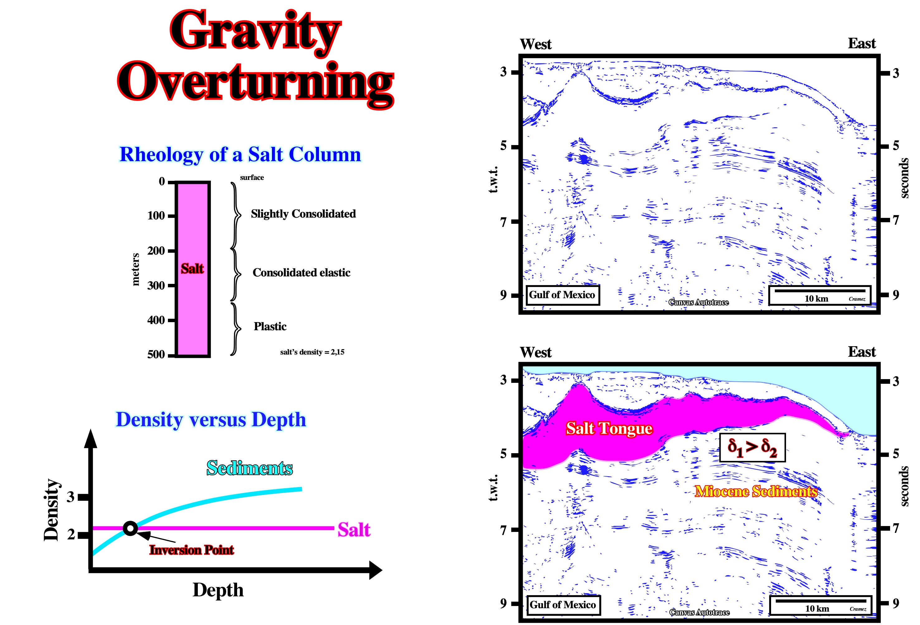
Salt can flow without or under a small overburden thickness. In absence of significant tectonic stress, a relatively thick salt column (> 400 m) shows different rheologies. From top to bottom: (i) Slightly consolidated, (ii) Consolidated elastic and (iii) Plastic. The deeper plastic interval can flow just due to the height of the upper intervals. In the shallow part of sedimentary basins, between the surface and 1,500 metres depths, the density of the salt, which is more or less constant, is higher than the density of the sediments. However, below the inversion point, the density of the sediments is higher than the salt density. In Gulf of Mexico, the age of the salt is Jurassic. On this Canvas autotrace, stratigraphic speaking, the allochthonous salt layer is much older than surrounding sediments (Mio-Pliocene). However, as the density of the salt is constant in depth, when an allochthonous salt layer is above the inversion point, it is denser that the surrounding sediments.
Gravity Gliding
Downslope sliding of an overburden sheet or block under its own weight over a weak, ductile décollement (such as salt). The base of the overburden must dip sufficiently that gravitational body force is resolved into a downslope shear stress that is large enough to overcome the shear strength of the décollement layer or the frictional strength of the décollement fault. In salt tectonics, this dip is provided by a continental slope or delta front.
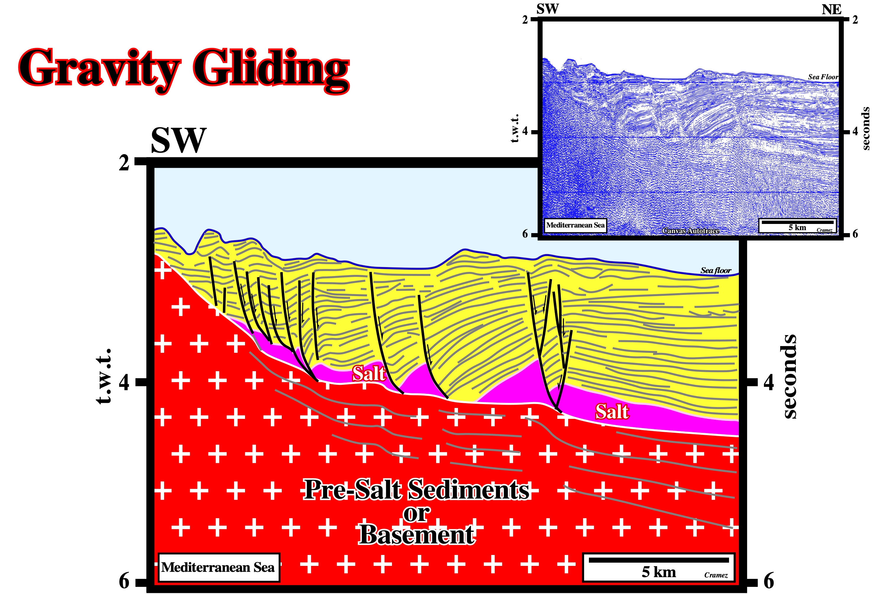
Near the pinchout of the Messinian salt layer, the overburden glided as salt evacuate basinward and the associated growth-faults, die on the top of the salt or on the salt weld.
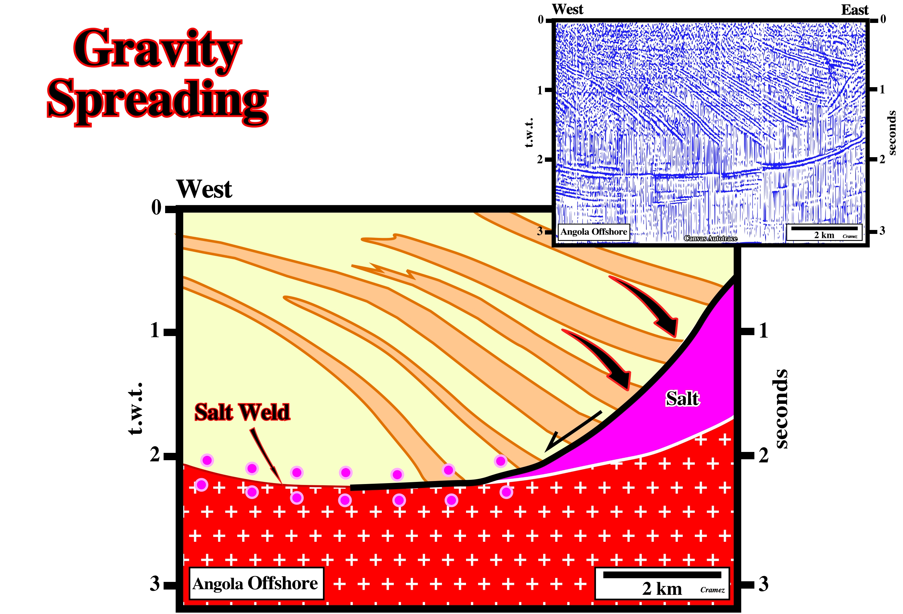
Gravity Spreading
Lateral spreading of salt (and commonly its overburden) above the level of neutral buoyancy. A dipping upper surface allows a small component of the gravitational body force to be resolved into a down-slope shear stress to drive spreading. Examples are the spread of salt glaciers or lateral injection of salt sheets.
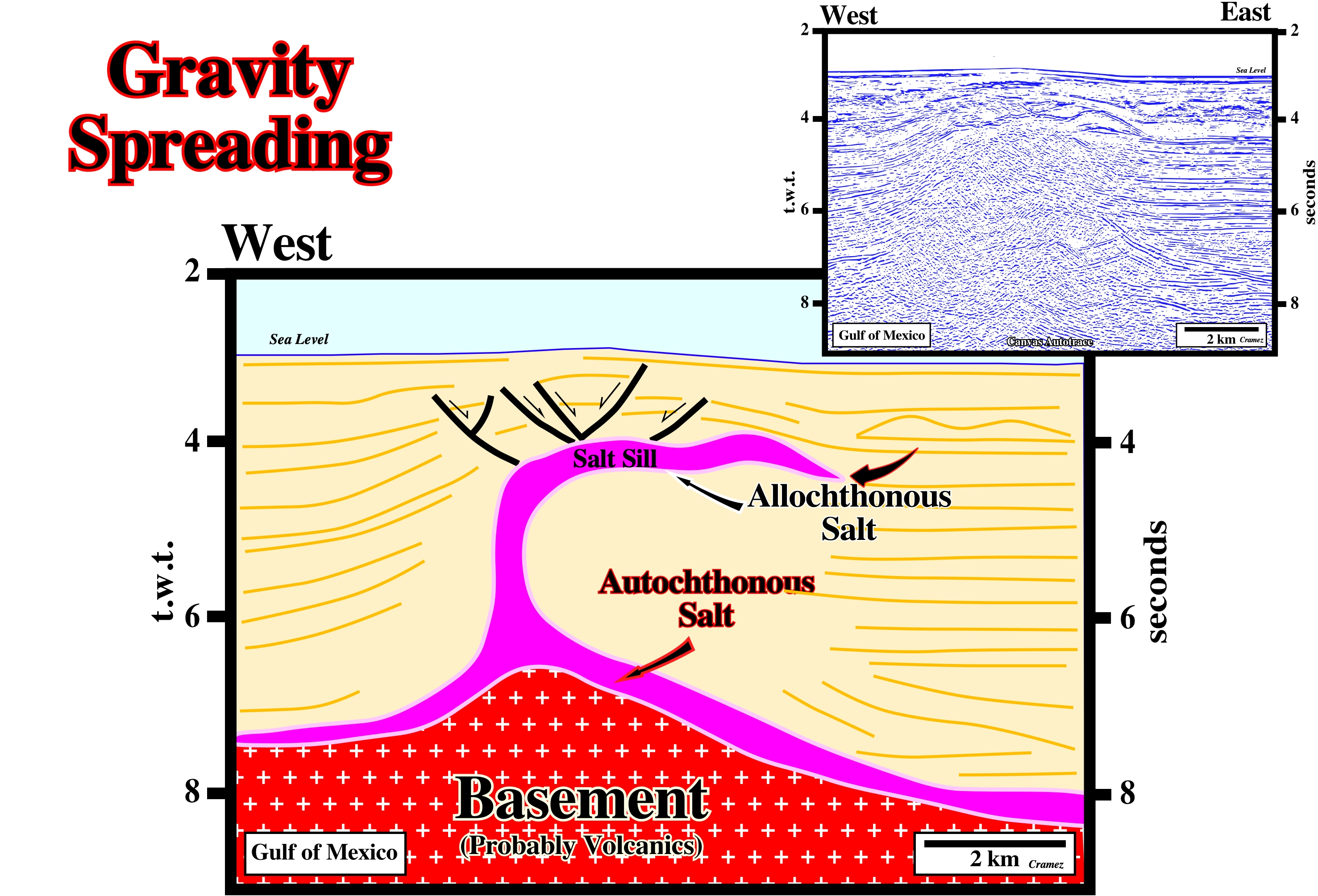
A lateral spreading of the salt is quite evident on this tentative interpretation of a Canvas autotrace of a GOM seismic line. The dipping upper surface of the salt creates a downslope shear stress, which partial drives the seaward spreading.
Growth-Fault
A fault in sedimentary rock that forms contemporaneously and continuously with deposition, so that the throw increases with depth and the strata of the down-thrown side are thicker than the correlative strata of the up-thrown side.
Contrariwise to the progradations of the shelf breaks in a regressive interval, which are characterized by downlap geometric relationships, in a growth-fault, induced by salt flowage, as illustrated above, the hangingwall configuration is divergent (against the fault plane) suggesting a differential subsidence. The geometric relationships of the chronostratigraphic lines of the hangingwall are apparent downlaps, that is to say, they are tilted onlaps.
Gumbo Zone
Name given in Gulf of Mexico to the structural disrupted zone, directly under allochthonous salt, which works as a permeability pathway. Fluid flushing through this zone develops hyper-pressures, in the section immediately below the salt, which create big problems during drilling.
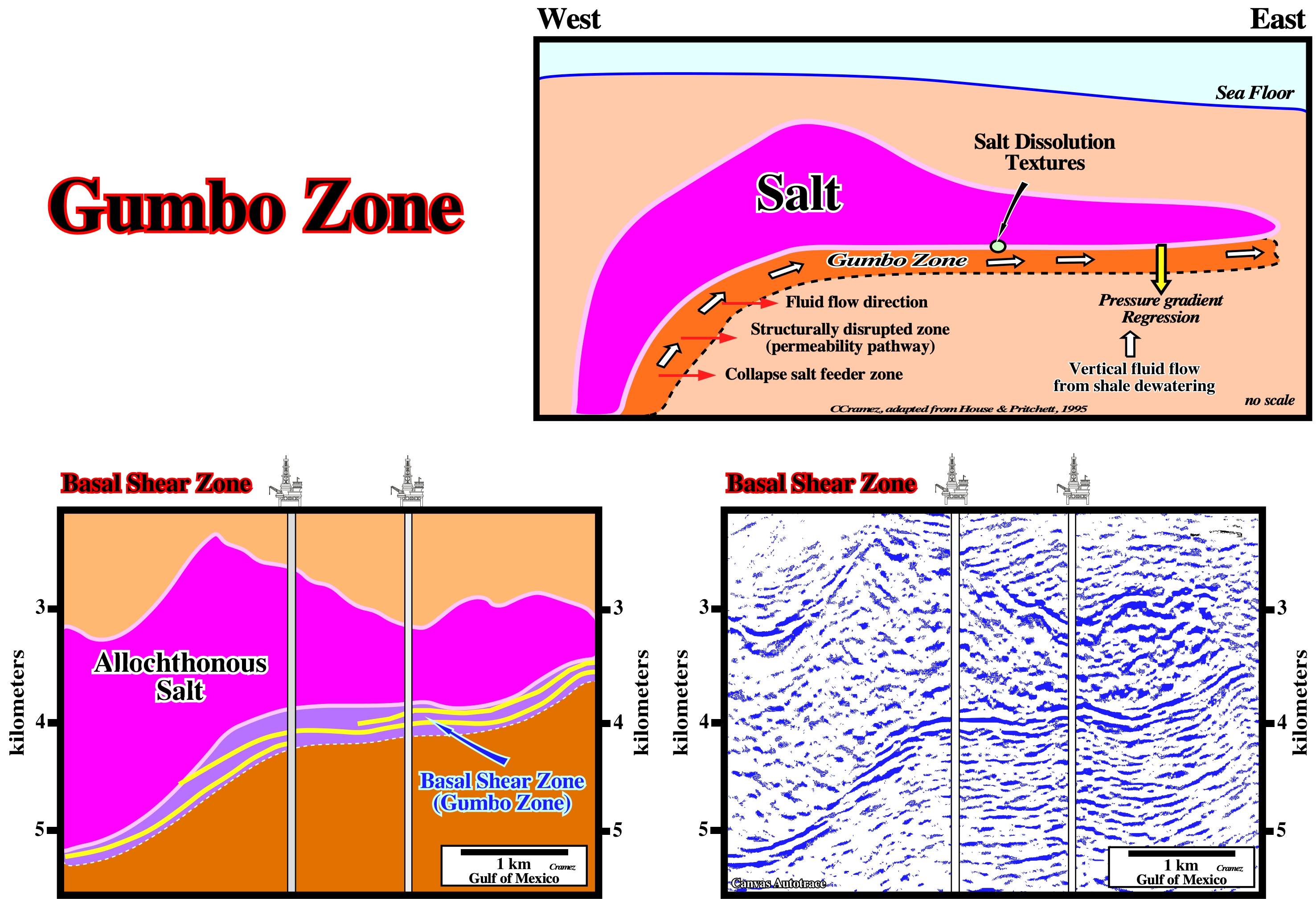
The Gumbo zone was discovered when oil companies tested the hydrocarbon potential of subsalt prospects. They found major drilling problems at the bottom of the salt layer due to the over-pressures of the Gumbo zone. On the other hand, seismic interpreters soon realize the seismic marker associated with the bottom of the salt, was, actually, induced by the Gumbo zone rather than by the salt. So, when an obvious bottom of allochthonous salt is recognized on a seismic line, the chances that a Gumbo zone is present are quite high.
Gypsum
A widely distributed mineral consisting of aquated calcium sulfate: Ca(H2O)2(SO4). It is the commonest sulfate mineral, and is frequently associated with halite and anhydrite in evaporites, forming thick, extensive beds interstratified with limestone, shale, and clay (esp. in rocks of Permian and Triassic age).
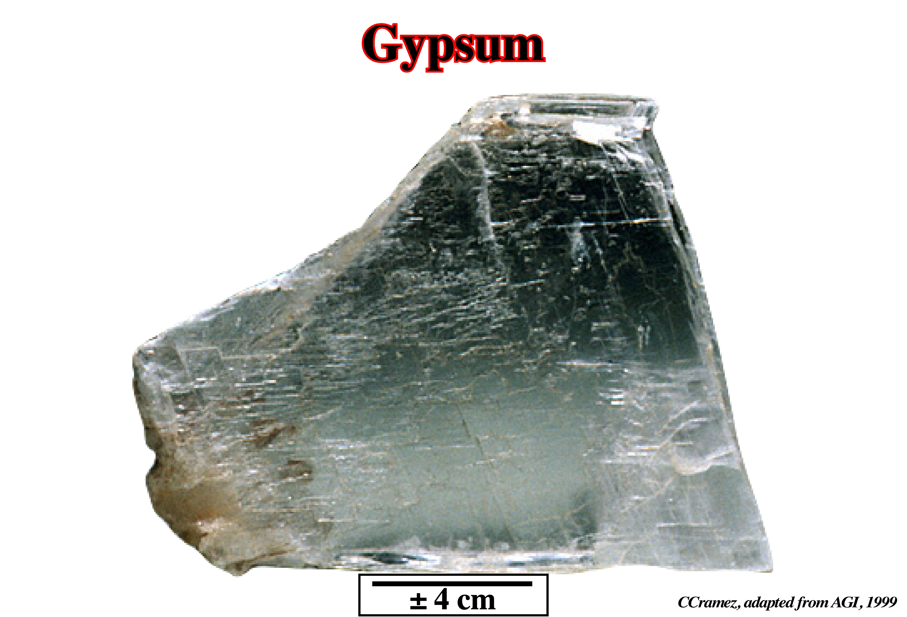
Gypsum is soft (hardness of 2 on the Mohs scale). It is white or colorless when pure, but commonly has tints of gray, red, yellow, blue or brown. It occurs massive (alabaster), fibrous (satin spar), or in monoclinic crystals (selenite). Gypsum is used chiefly as a soil amendment, as a retarder in Portland cement, and in making plaster of Paris.