
Hade (in Structural Geology)
The angle that a structural surface (fault plane for instance) makes with the vertical, measured, perpendicularly, to the strike.
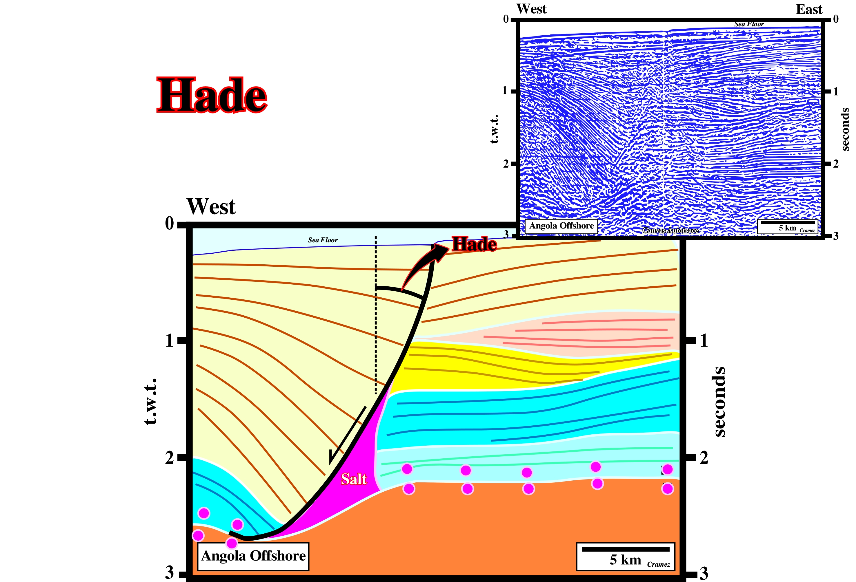
The constant increasing of the hade is one of the principal characteristics of growth-faults, which die, generally, on a detachment or decollement plane, as illustrated above. On this tentative interpretation of a Canvas autotrace of an Angola offshore seismic line, the top of the autochthonous salt or the associated salt weld operates as a detachment plane. The subsalt strata is, almost, undeformed while the overburden was strongly lengthened, i.e., the salt weld and the bottom of the salt mark a salt induced tectonic disharmony.
Haggis Structure
As the name suggest (Haggis is pudding containing sheep's pluck - heart, liver, and lungs- , minced with onion, oatmeal, suet, spices, and salt, mixed with stock, and cooked while traditionally encased in the animal's stomach) it is an inverted depocenter induced by an almost total salt reduction. This structures are quite frequent in North Sea, where some of them have been drilled for hydrocarbons. The inversion time in relationship to the hydrocarbon migration time is a major exploration key parameter.
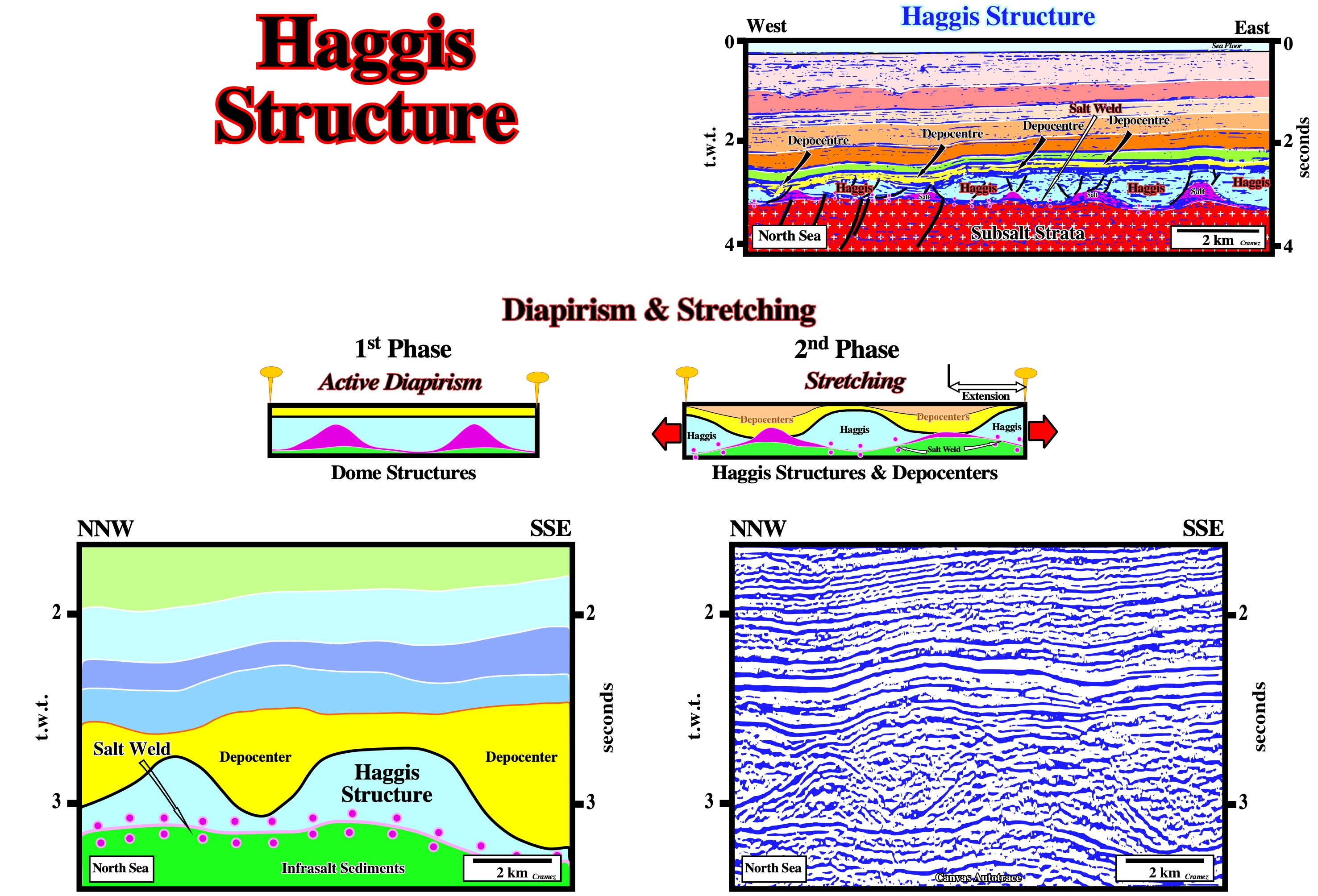
An Haggis structure corresponds to an apparent mound between two depocenters developed in association with salt welds. In the above geological sketch (Diapirism & Stretching), the interdomal synforms between the salt diapirs become apparent mounds by complete salt evacuation, i.e., by total evacuation of the salt. The depocenters become apparent mounds. They become inverted structures. The high points become low structural points. In the Haggis structures, as illustrated on the above tentative geological interpretation of a Canvas autotrace of a North Sea seismic line, the potential structural hydrocarbon traps must be critically tested: the age of the tectonic inversion must predate the age of the hydrocarbon migration, which is not always the case.
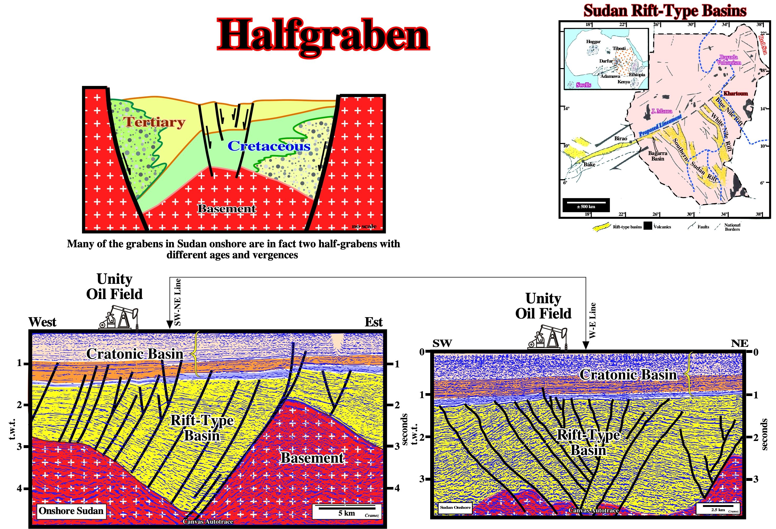
Halfgraben
Graben with a triangular geometry. On seismic lines, rift-type basins are often half-graben. Such a geometry is developed when the lengthening of the substratum is done along a syndepositional normal faults with an unique vergence. A lot of graben structures correspond to the association of two half-grabens with opposite vergence and different age.
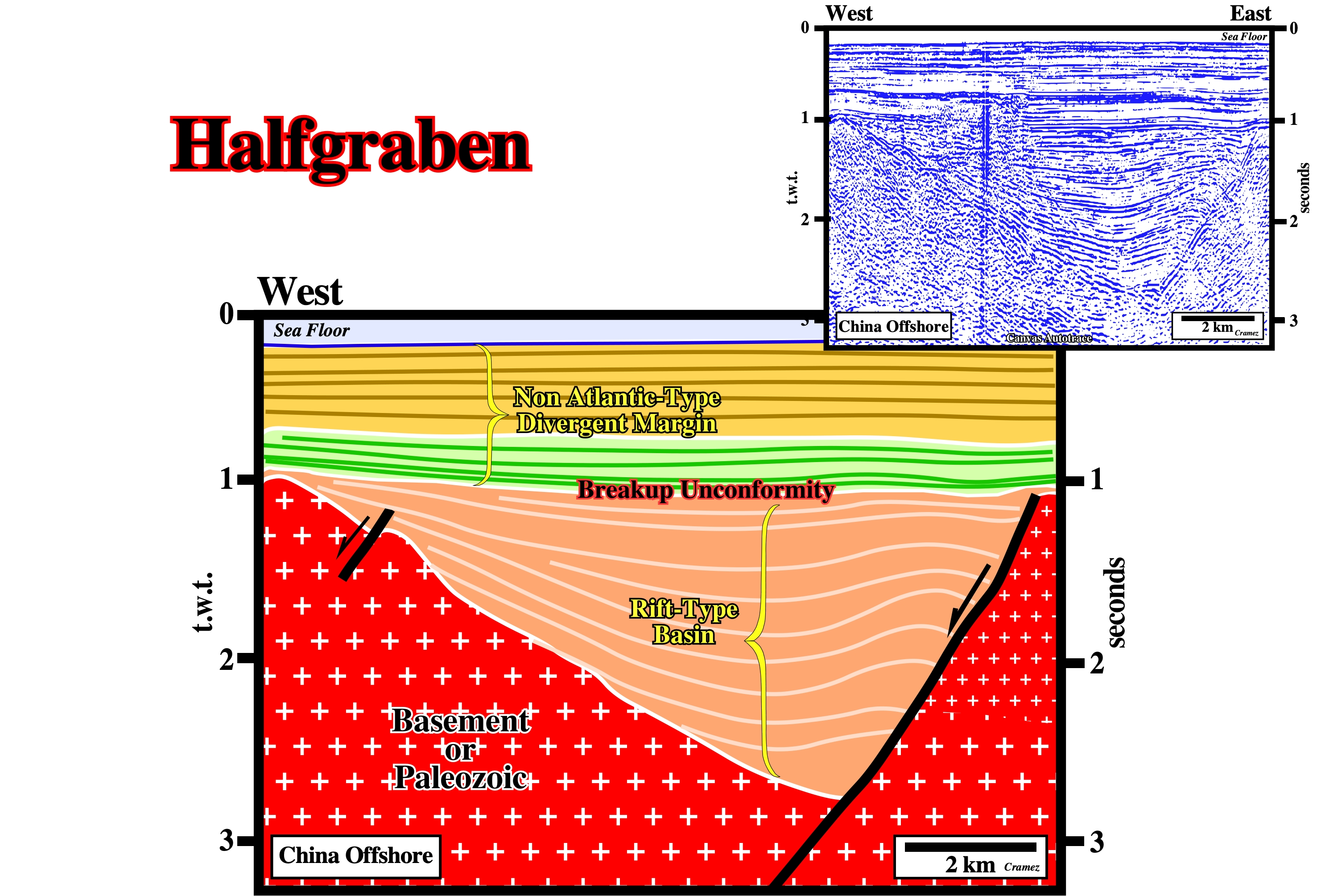
Typical Canvas autotrace from an offshore China seismic line, where the lengthening of the lithosphere created rift-type basins with a half-graben geometry, in which lacustrine source rocks were deposited. On this particular autotrace, it is interesting to notice the antiform, recognized on the left part of the half-graben, seems to be the consequence of a lithologic change in the substratum (Paleozoic sediments) rather the consequence of a compressional tectonic regime. A change in dip of the fault plane can create a local volume problem obliging the adjacent sediments to lengthen. A later reactivation of the bordering normal fault is also possible.
A lot of graben structures can, actually, be the result of a combination of two halfgrabens with different vergences and ages. This kind of structure is quite frequent in onshore Sudan. The tectonic sketch is based on a tentative interpretations of a Canvas autotraces of seismic line of this onshore (rift-type basins covered by cratonic basins). The lower tentative geological interpretations illustrate a major oil field of the Sudan onshore. The petroleum system is developed, exclusively, in the rift-type basin, i.e., the source and reservoir rocks were deposited in the rift-type basins. The trapping mechanism is a set of morphological traps by juxtaposition associated with the lengthening of the rift-type sediments.
Half Turtle Back Structure
Structure analogous to turtle back structure flanked by a single diapir. Synonym of pseudo or apparent turtle back structure.
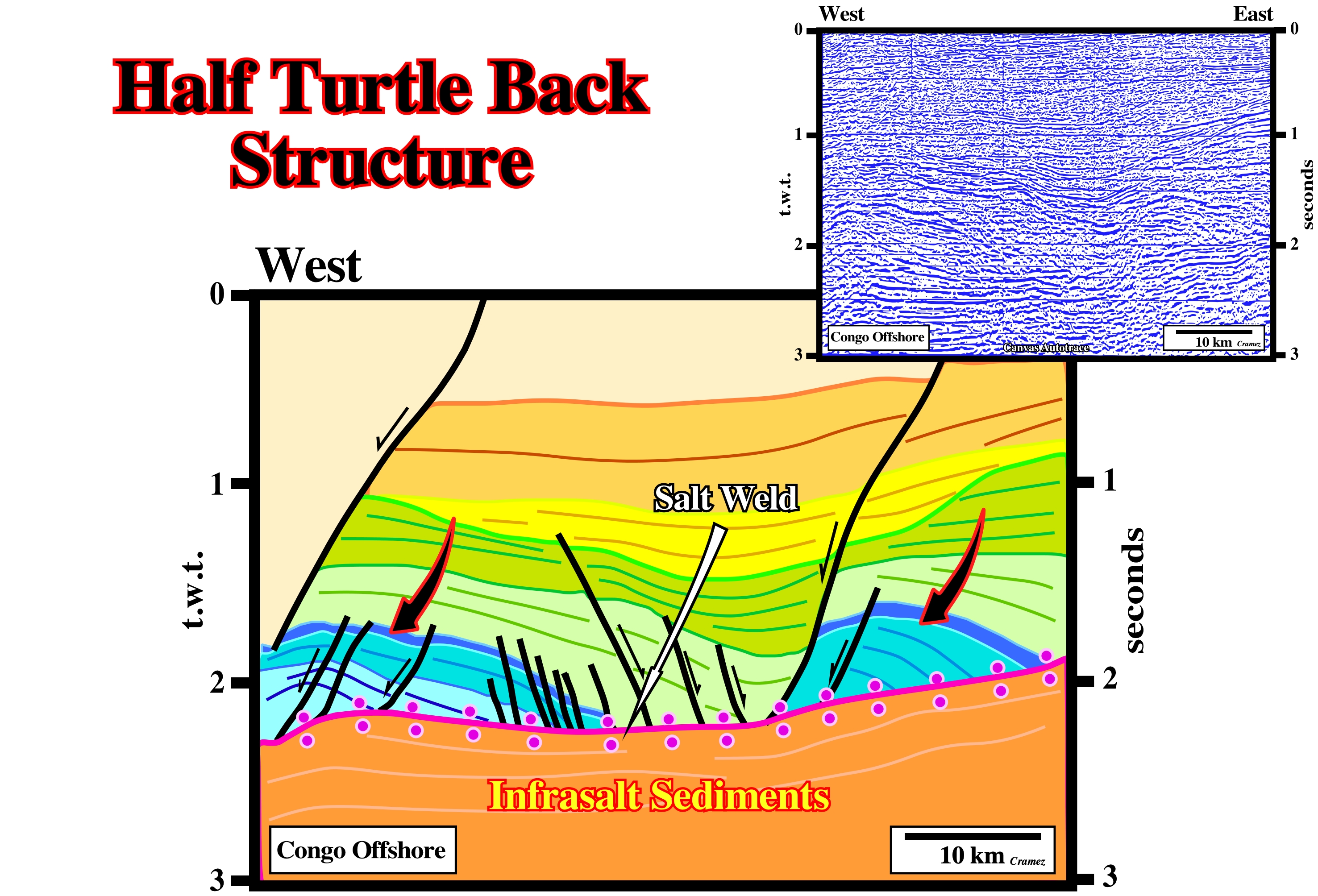
In a turtle back structure, there is always a tectonic inversion. The lower intervals of the overburden thick inward, while the upper intervals thick outward. Such a tectonic inversion, which is induced by salt flowage, creates in the central part large antiforms with a lot of normal faults lengthening the upper intervals. In an half turtle or pseudo-turtle structure, there is no inversion. The antiform is created just by a syn-sedimentary seaward gliding of the overburden over the salt or salt weld.
Halite
A ClNa mineral. Halite is the native salt. It occurs in massive, granular, compact, or cubic crystalline forms, and it has a distinctive salty taste.
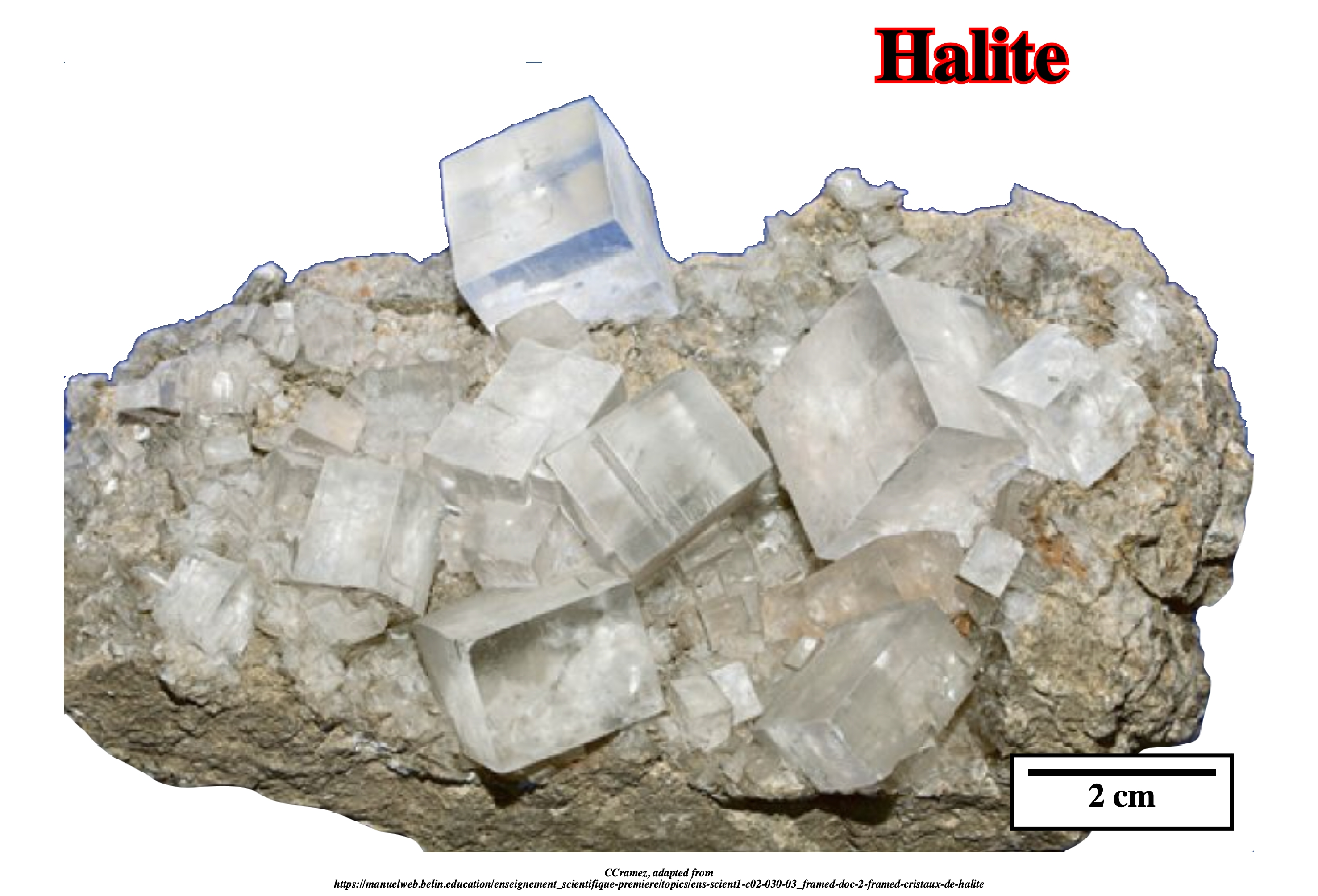
Halite is, typically, colorless, but certain occurrences provide red, yellow, blue colors owing impurities and/or color centers in the structure. Halite deposits can be formed by evaporation of: (i) Seawater (abundant, but critically dependent on sea level) and (ii) Hydrothermal water (possibly less abundant but mostly independent of the sea level). The geochemistry of rock salt (halite) is, rarely, diagnostic to distinguish between these two brine sources. Potash evaporites are much more diagnostic of brine source than are halite deposits. Potash evaporites form two groups: 1) A rare group rich in MgSO4 formed by evaporation of seawater originating from rivers. The sulphate mineral, polyhalite, kainite and kieserite are diagnostic, which occur in the Vendian, Late Mississippian to Permian and Miocene to Quaternary. 2) A group, more common, is rich in KCl and CaCl2 and poor in MgSO4, which cannot be formed by evaporation of seawater from rivers alone. The chloride minerals, such as sylvite, carnalite, tachyhydrite and bischofite are diagnostic. This group formed in Cambrian through Early Mississippian and Jurassic through Paleogene. These KCl minerals originate from brines enriched in CaCl2 by hydrothermal water rock interaction.
Halokinesis
Form of salt tectonics in which salt flow is powered by buoyancy, that is, by release of gravity potential energy alone, in absence of significant lateral tectonic forces (σt = 0).
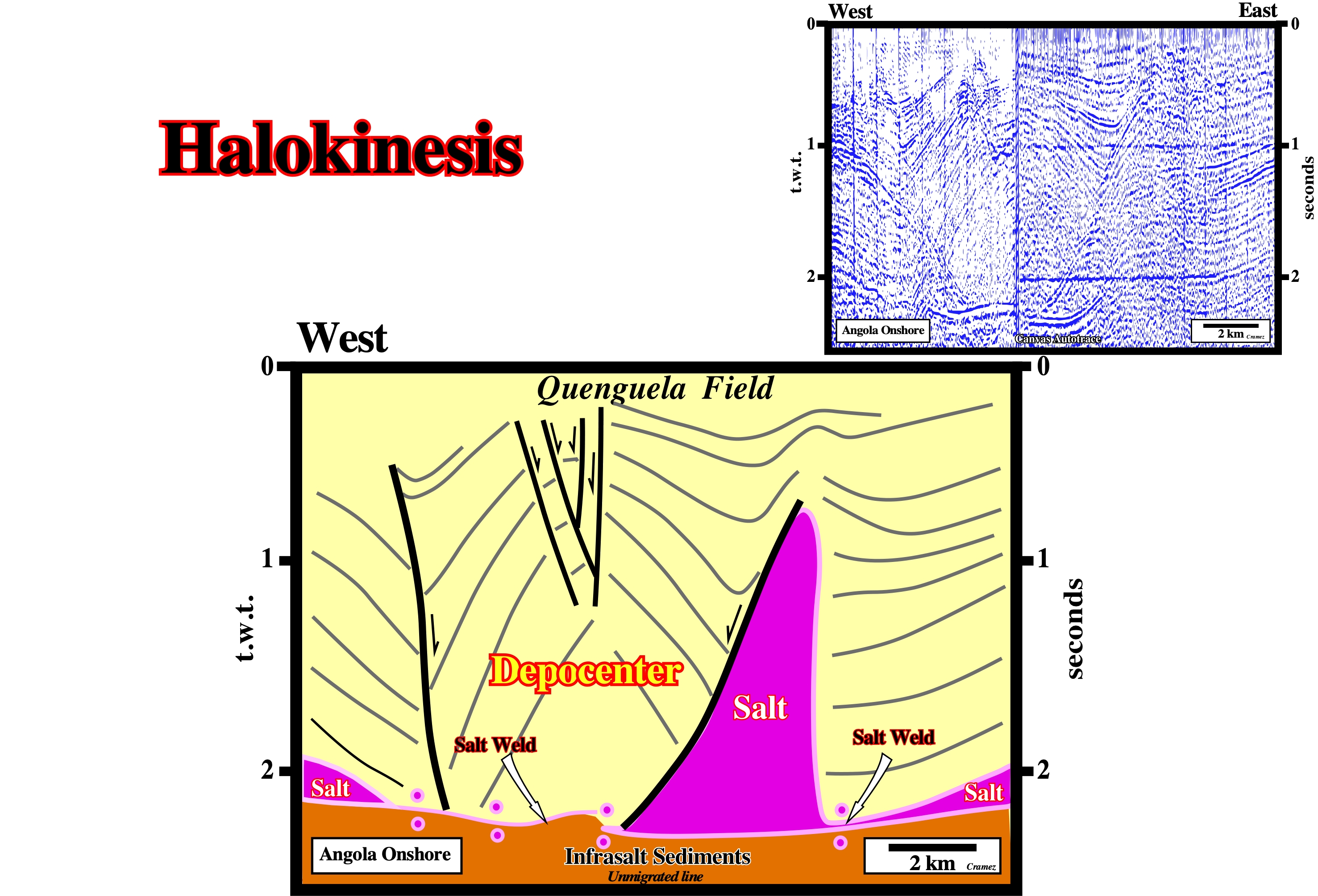
In the beginning of the 19th century, the geoscientists of Synclair (American oil company) studying the Angola onshore (Kwanza geographic basin) found enigmatic important lateral thickness variations on their geological cross-section. In the 60's, the geoscientists of Petrangol (Petrofina) studying the same onshore advanced the hypothesis that the structures and thickness variations observed on the geological cross-section and tentative geological interpretations of the poor quality seismic lines (see Canvas autotrace above), were induced by salt flowage in absence of a significant tectonic stress (σt = 0). They explained the antiform structure (turtle back) and the associated depocenters as the consequence of a compensatory subsidence. Above, is illustrated a Canvas autotrace of the original composite seismic line, on which Petrangol's geoscientists located the successful Quenguela ≠1 (± 40 Mbbls of recoverable reserves), which is the largest oil field in all Angola onshore (Kwanza and South Congo geographic basins).
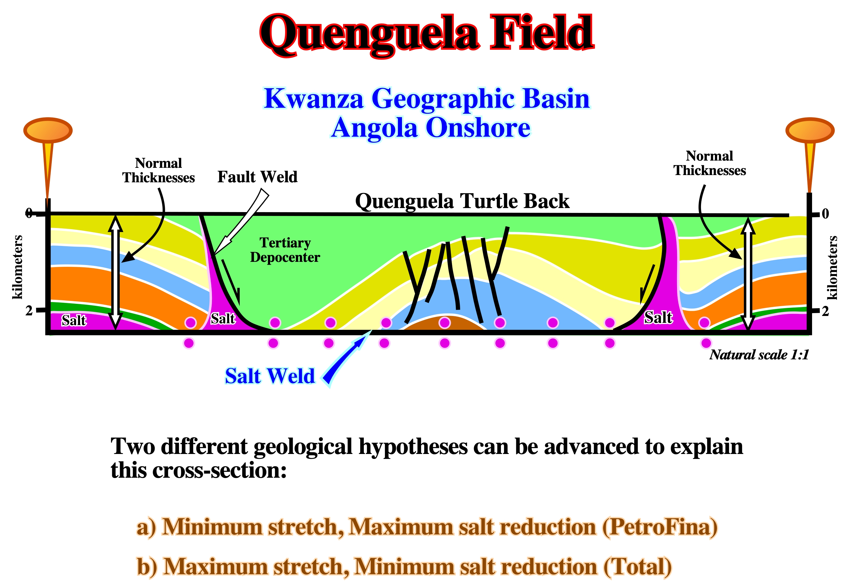
Two major hypothesis were suggested to explain the Quenguela turtle back structure. The first one, without lengthening of the sediments and in absence of a significant tectonic stress (Halokinesis) was proposed, in the 60's, by Petrangol's geoscientists. Later, by the end of 80's, Total's geoscientists proposed an hypothesis in which extension and salt flowage contributed to the development of the turtle back. Globally, at the scale of the basin, Total's hypothesis seems more likely. A significant compressional tectonic regime counter-parting and updip extension is obvious on the new regional deepwater seismic lines.
Halotectonics
Synonym of Halokinesis.
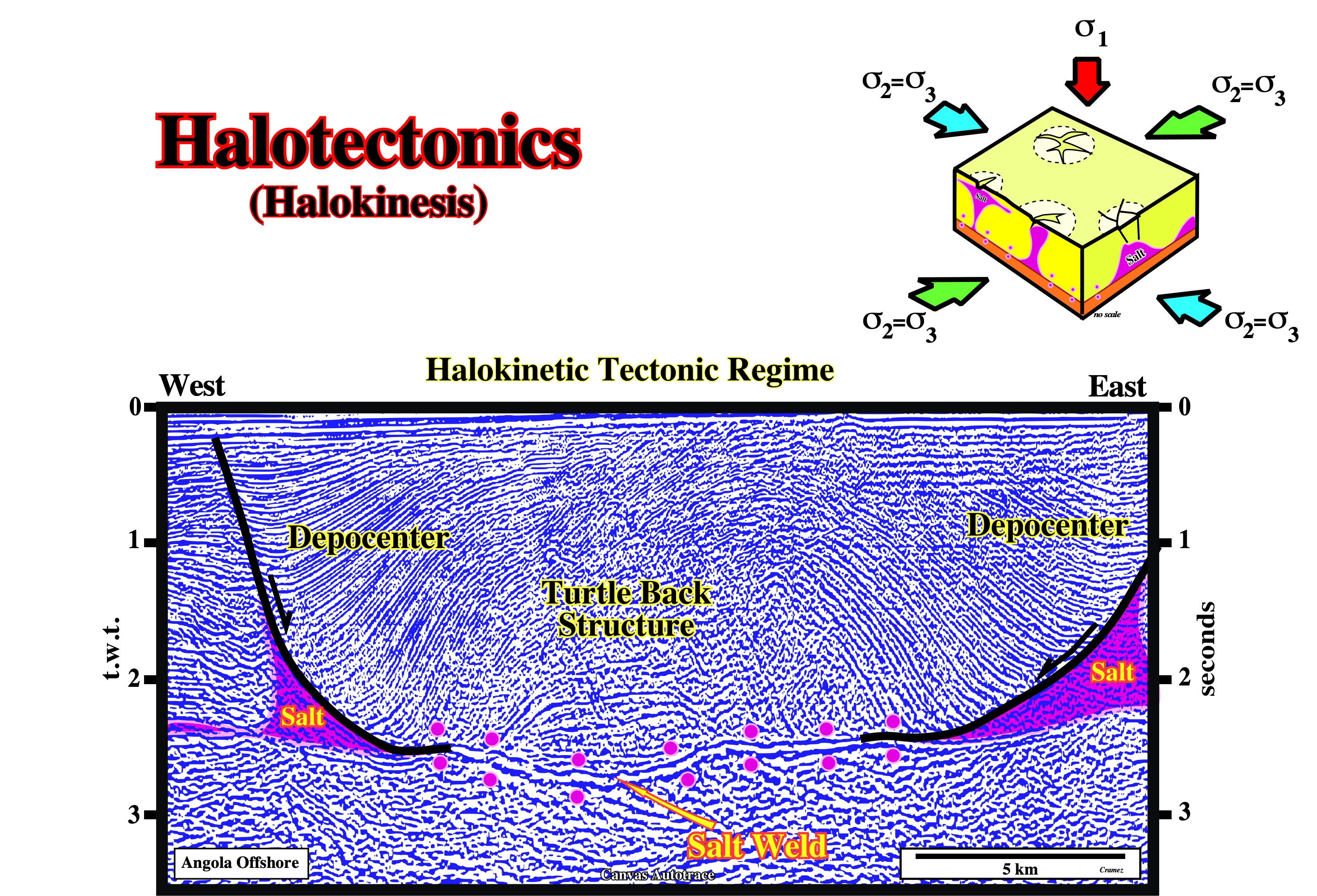
This antiform structure is a typical extensional structure created by halotectonis (halokinesis). The lateral depocenters are synkinematic intervals deposited in association with a compensatory subsidence created by salt flowage. The core of the structure, which is mainly prekinematic, was inverted by halokinesis. The normal-faults (with opposite vergence) near the apex of the structure strongly extend the overburden. As illustrated in the block diagram, the faulting associated with this tectonic regime is characterized by normal-faults striking in all directions (σ2 = σ3). This fault pattern is also, often, recognized on antiform structures created by differential compaction. When, a thick mobile layer (salt or undercompated shale) is present, even in absence of a significant tectonic stress, it can flow by itself. Halokinesis designates the salt and overburden deformations taking place in such a tectonic setting (absence of a tectonic stress), while shalokinesis denotes the deformations associated with an undercompated shale interval.
Hangingwall
The overlying side of an orebody, fault, or mine working. Presently, and particularly in oil industry hangingwall is used to express the wall rock above an inclined vein or fault.
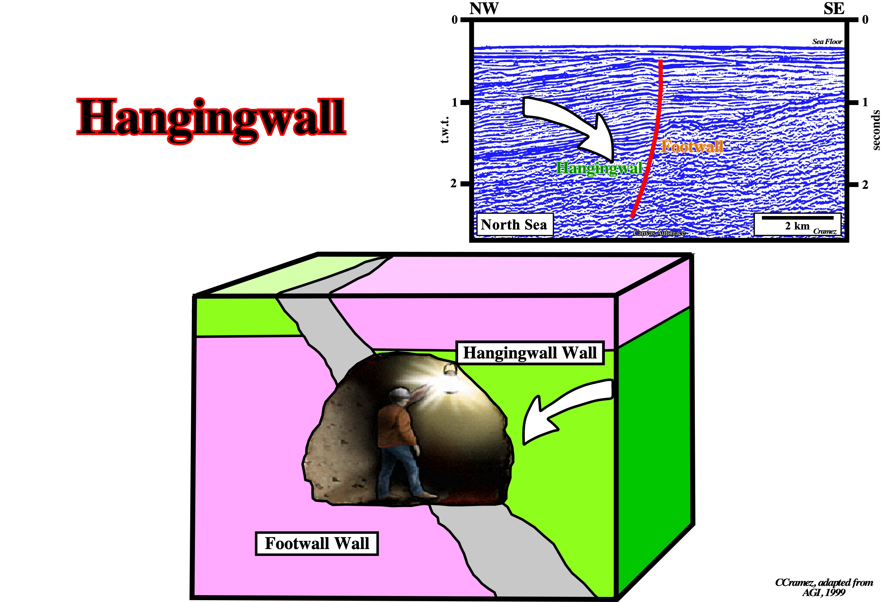
The hangingwall is a synonym of the downward fault block, i.e., the faulted block that has a downward relative movement in relation to the up-thrown block.
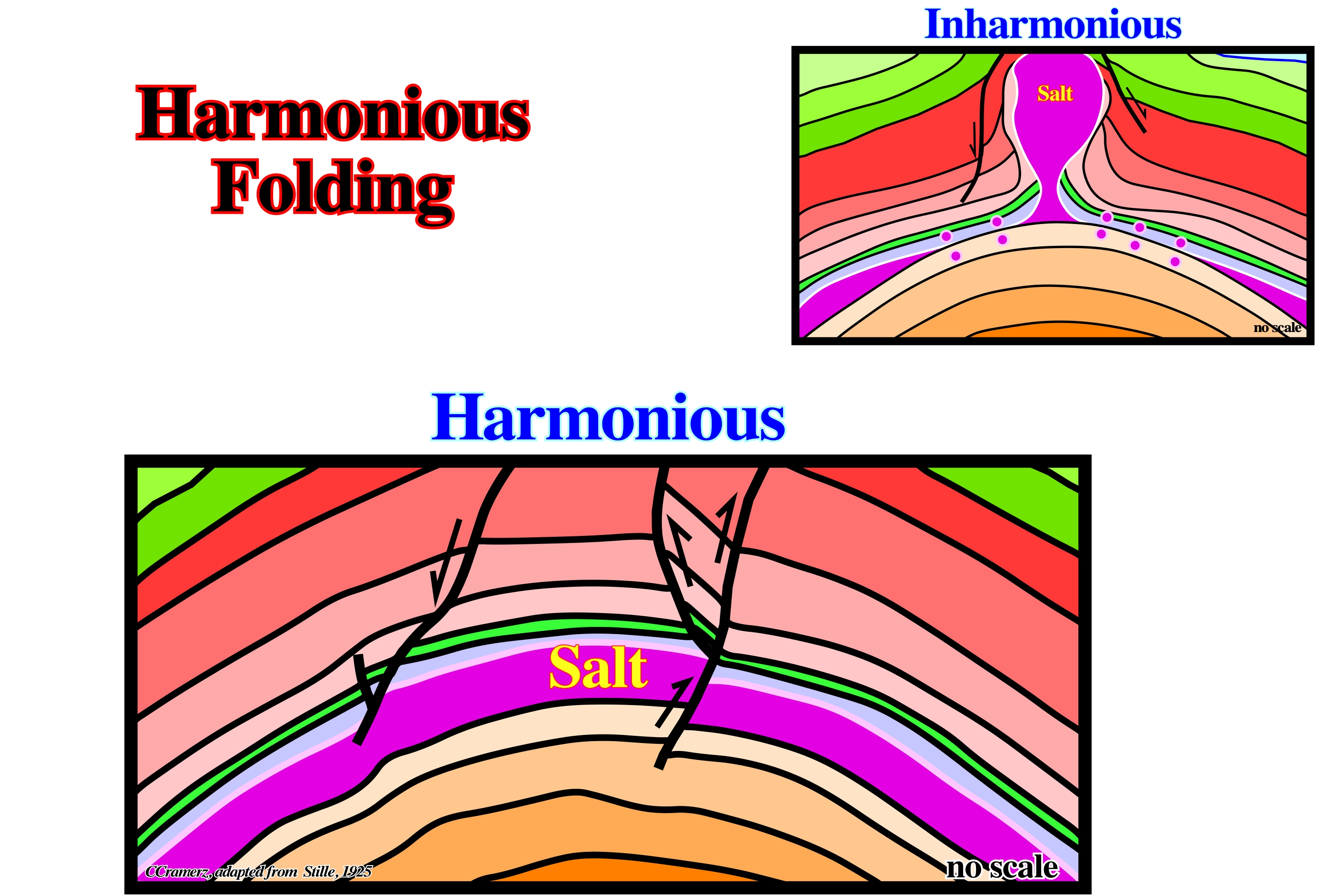
Harmonious Folding
See: Inharmonious folding.
Stille (1925) considered two kind of folding: (i) Harmonious when the beds have a similar strength and (ii) Inharmonious when the beds have different strength, particularly one an high mobile layer is interbedded. The different geometries of both foldings are illustrated below.
Hedreocraton (McNeill, L. et al., 1999)
A stable, continental craton, including both continental shield and platform. Synonym of Epeirocraton.
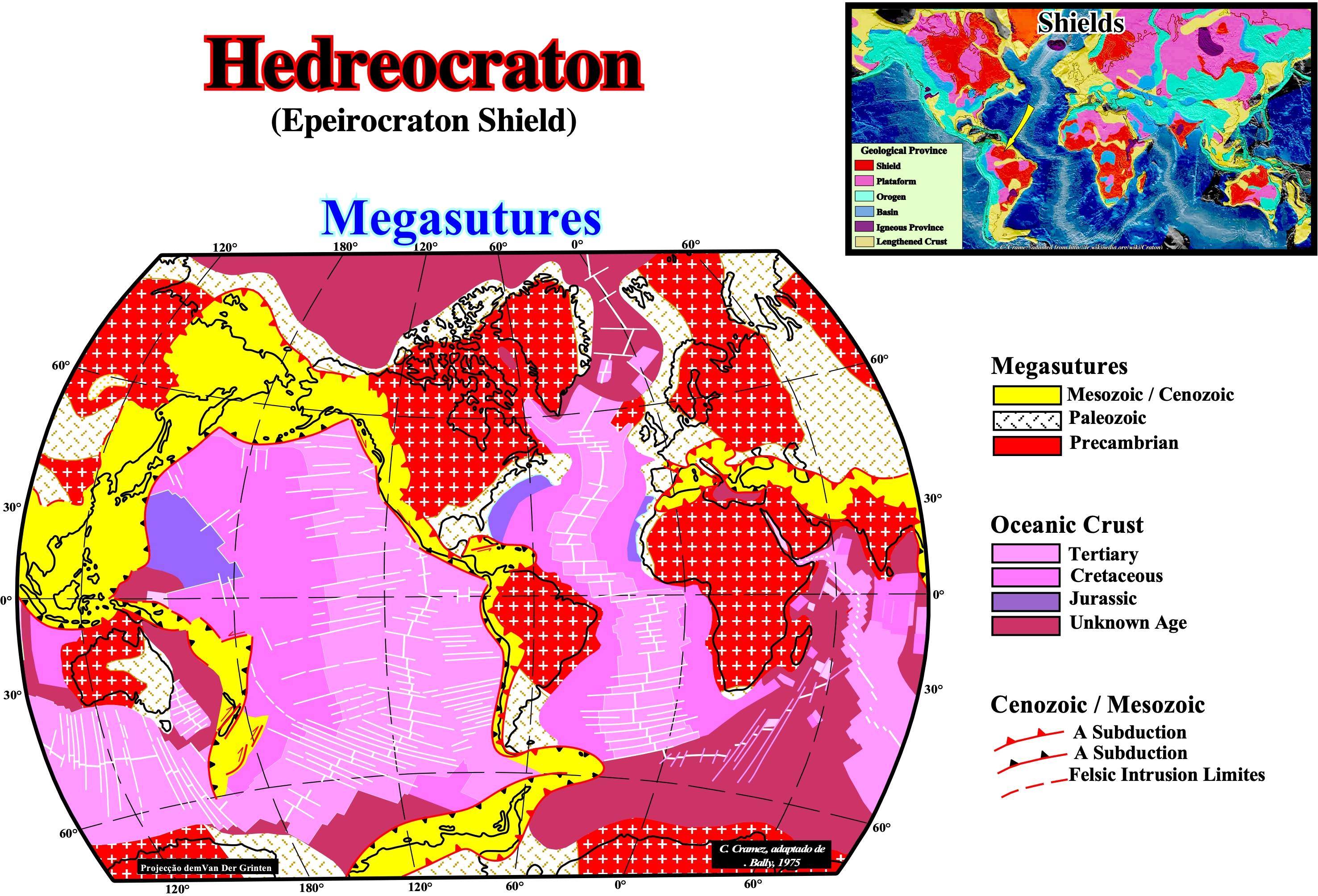
The majority of the hedrecratons (roughly, cratons or shields) area associated with the Precambrian or Paleozoic megasutures. The areas of the Earth's crust that have attained stability, and have been little deformed for a prolonged period, are called, generally, cratons or shields. Cratons included parts of both continents and ocean basins and are restricted to continental areas. The central cratons of the continents, including both shields and platforms, have been called hedreocratons. A thalossocraton is a tectonically relatively stable area of the sea floor (R. Fairbrige, 1955). With the discovery of the world systems of mid-ocean ridges, which are tectonically active belts of the ocean floor, it became obvious that the term thalossocraton cannot include these ridges.
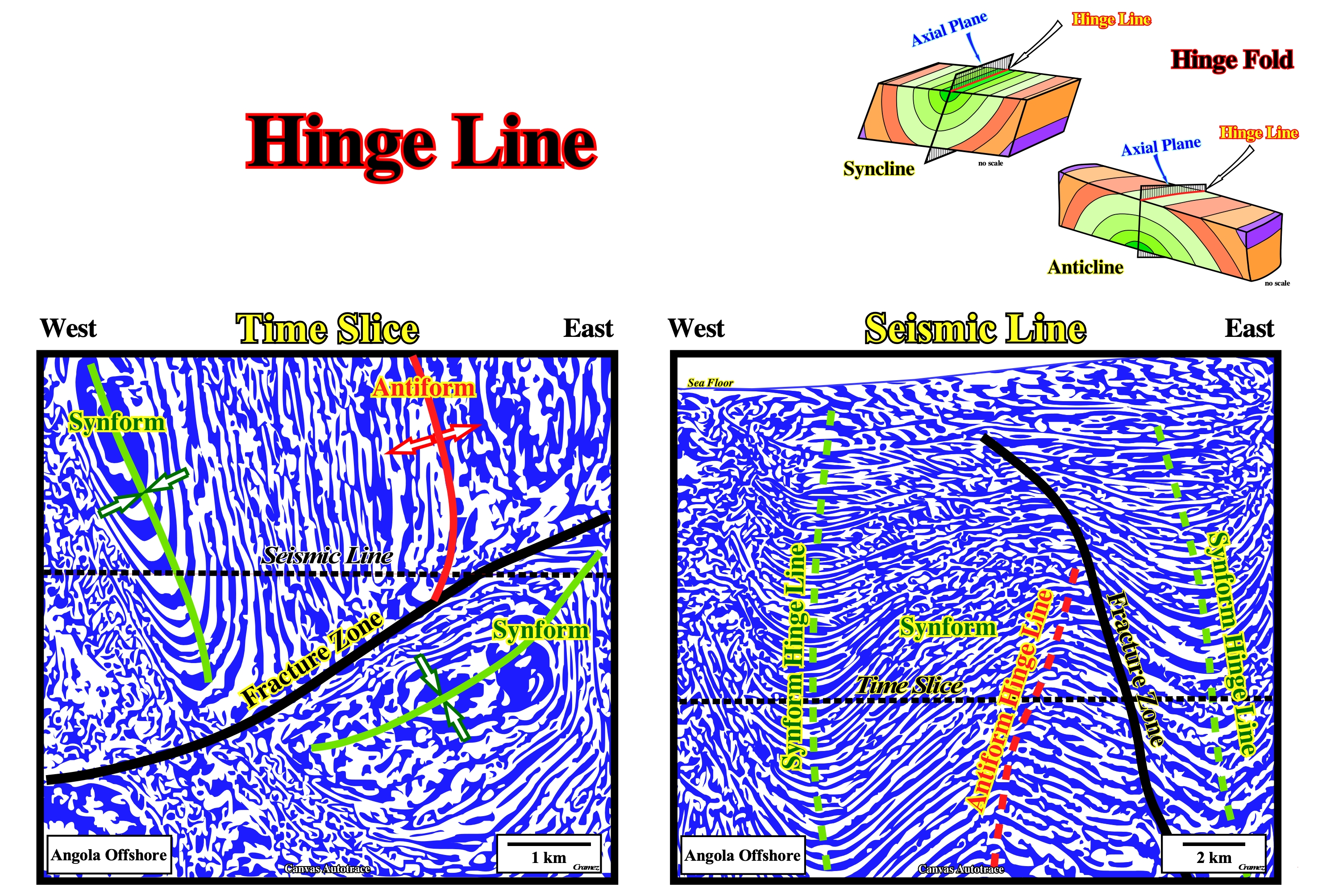
Hinge Line
Synonym of fold hinge.
On seismic data, the hinge line, that is to say, the imaginary line that connects points maximum curvature of compressional (anticlines and synclines) or extensional (antiforms and synforms) structures is, easily, picked not only on time slices, but seismic lines as well. In cylindrical structures, i.e., in folds (either concave down or concave up) with straight hinge lines, the hinge line and the fold axis is the same. In non-cylindrical folds the hinge lines are curved. According to the Law of Superposition, the top (the highest) layer of sediment should be the youngest both on concave down or concave up structures. If the oldest layer of an anticline is at the very top, the structure is overturned. The terms right limb and left limb are used to refer to rock layers that have right and left sinusoidal curves. The axial plane or axial surface is at the very top or bottom in which the limbs are on either side of it. The axial plane is the imaginary line or surface of symmetry. (http:// sanuja.com/blog/geometry-of-folds).
Hydrodynamism
Displacement of aquifers induced by pressure gradients in potential reservoirs. Hydrodynamism can be centripetal or centrifugal. It can enhance, or destroy, the closure of a trap. It enhance the closure when the hydrodynamic flow is in the opposite sense of the migration of the hydrocarbons. Contrariwise, it can destroy the trapping, i.e., when the flow is in the same sense of the migration of the hydrocarbons.
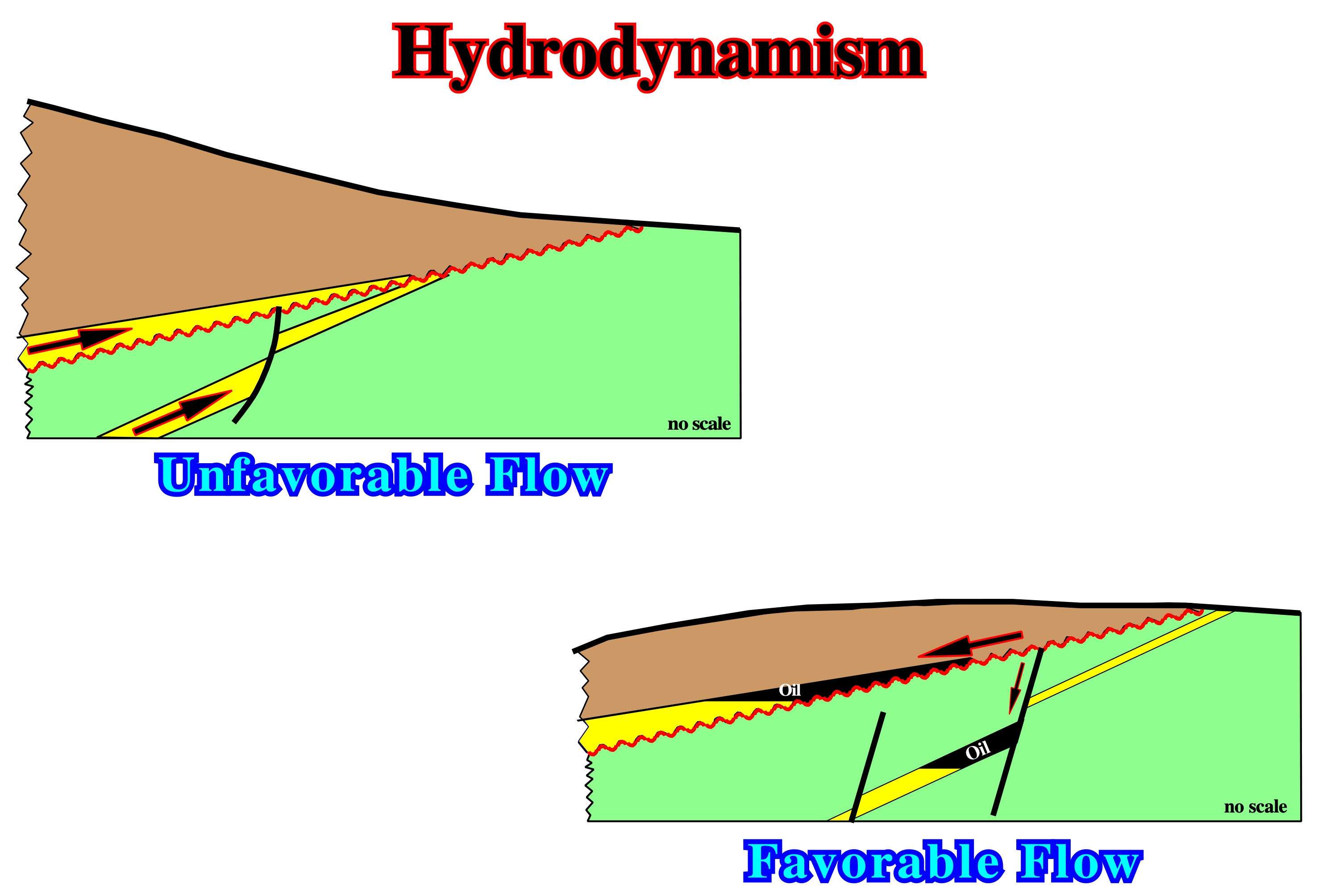
Levorsen (1966) showed an hydrodynamic flow can destroy, or favor, a non-structural trap. Indeed, when the aquifer flow is in the sense of hydrocarbon migration, the probability that a non-structural traps accumulate hydrocarbons is quite small. Actually, several geologists point out, an economical accumulation and particularly, a giant oil accumulation, is, almost always, characterized by the presence of three trapping components: (i) Structural, (ii) Stratigraphic and (iii) Hydrodynamic.
Hydrostatic Pressure
Stress that is uniform in all directions, as beneath a homogeneous fluid. It causes dilation rather than distortion in isotropic materials. See: Pore Pressure.
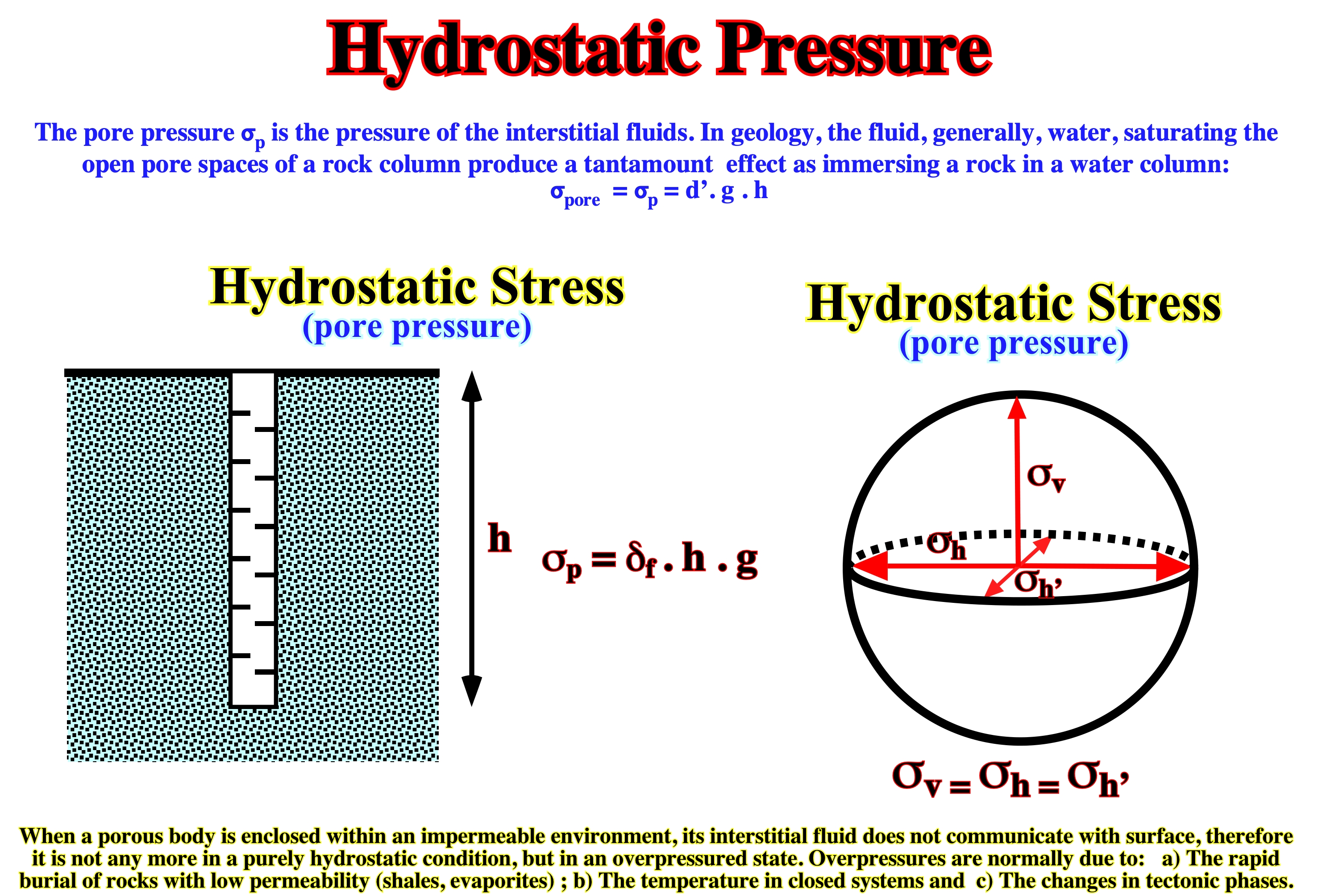
Interstitial pore pressures act on the grains of a rock in opposite direction of the lithostatic and tectonic stresses. Pore or hydrostatic pressure acts in opposite direction of the lithostatic pressure. It explains buoyancy, i.e., the upward thrust on a body immersed in a fluid. This force is equal to the weight of the fluid displaced (Archimedes’ Principle). As pore pressure (σp), or interstitial pressure (hydrostatic = isotropic pressure), acts against the rock grains in the opposite sense to the lithostatic or geostatic stress, the effective vertical pressure amounts to the lithostatic pressure reduced by hydrostatic pressure or whatever pore pressure present. In an open water system all pores are in communication. In absence of tectonic stress, the depth evolution of pore pressure (σp), geostatic pressure (σg), and vertical effective pressure can be represented by a cross-plot depth/vertical pressure. In absence of tectonic stresses, the presence of overpressure zones reduces the effective vertical pressure, which evolves in depth. The overpressures are, normally, due to: a) The rapid burial of rocks with low permeability (shales, evaporites) ; b) The temperature in closed systems ; c) The changes in tectonic phases. Since these conditions produce: (1) Abnormal porosities and (2) Low densities. The overpressures can explain: (i) Growth faulting ; (ii) Under-compacted shales ; (iii) Mud volcanoes ; (iv) Slumping ; (v) Tectonic soles and overthrusts.
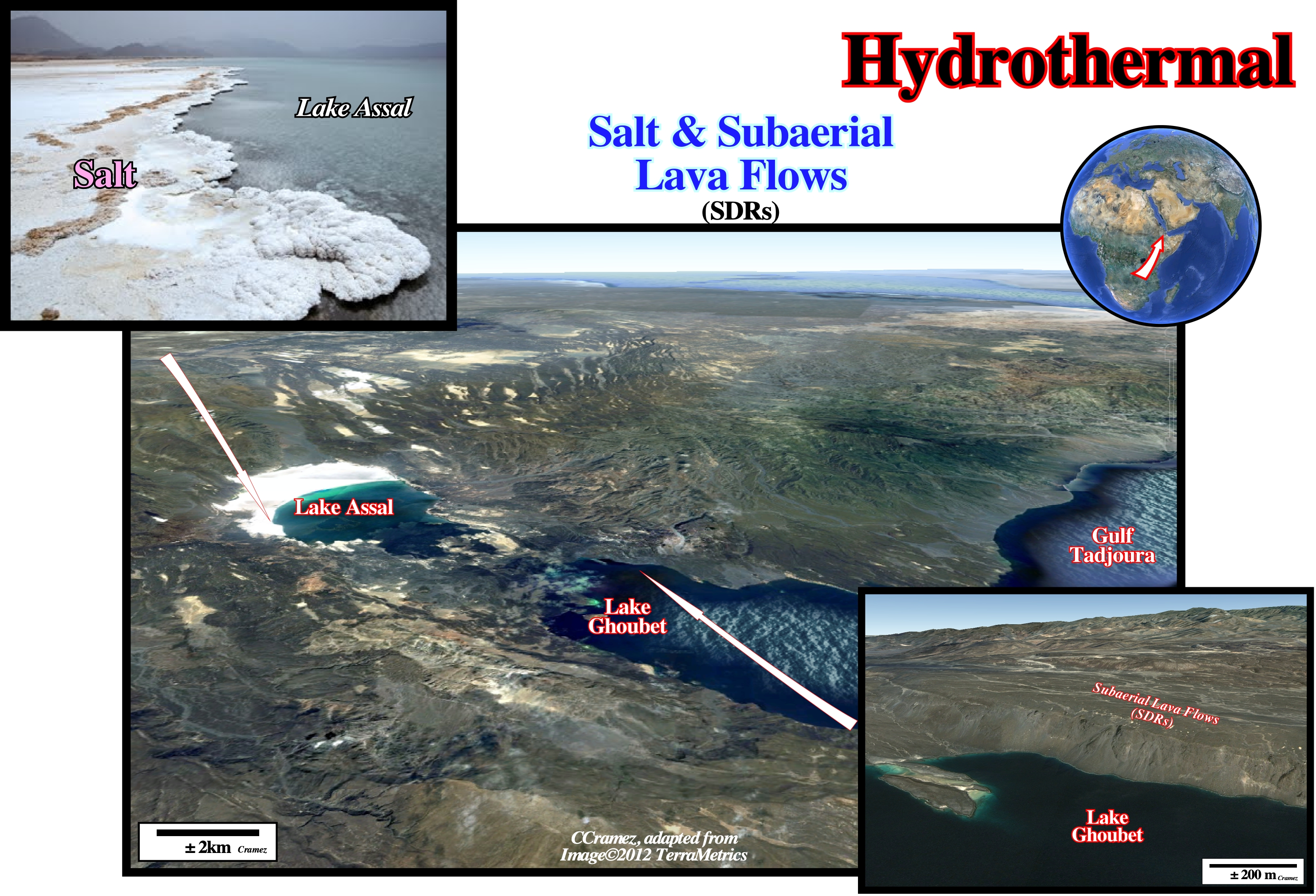
Hydrothermal (Salt /SDRs)
Said of or pertaining to hot water, to the action of the hot water or to the products of this action, such as a mineral deposit precipitated from a hot aqueous solution with or without demonstrable association with igneous processes; also, said of the solution itself. Hydrothermal is, generally, used for any hot water but has been restricted by sole to water of magmatic origin. The traditional evaporite model, in which salt rocks are formed by evaporation processes of shallow saline waters at surface environments seems to be just one way of explaining all the salts appearing on Earth today. Since long time petroleum geoscientists recognized the importance of hydrothermalism in brine formation. A new Hydrothermal Salt Theory was advanced (Hovland et al., 2006), in which salt is originated from hydrothermal systems deep-through where supercritical water acts on stage at certain conditions of pressures and temperatures in a superior range of the superficial environments.
The evidence of the association of evaporites with basalts is supplied by evaporite geochemistry and mineralogy, based on the work of Hardie (1983, 1990, 1996): (i) Evaporites can form from either seawater or hydrothermal brine ; (ii) The geochemistry of halite is rarely diagnostic to distinguish between these two brine sources ; (iii) Potash evaporites are much more diagnostic of their brine source, even though they are rare, forming only in the final stage of seawater evaporation after limestone, dolomite, gypsum and halite have begun to precipitate ; (iv) Potash evaporites form two group ; (v) A rarer group rich in MgSO4 forms by evaporation of seawater originating from rivers, in which sulfate minerals, polyhalite, kainite and kieserite are diagnostic ; this group formed in the Vendian, Late Mississippian to Permian, and Miocene to Quaternary ; (vi) The second group is more common and rich in KCl and CaCl2 and poor in MgSO4 ; (vii) This group cannot form by evaporation of seawater from rivers alone (chloride minerals, sylvite, carnalite, tachyhydrite and bischofite are diagnostic), it formed in the Cambrian through Early Mississippian and Jurassic through Paleogene. CaCl2 brines that concentrate to form KCl minerals originate from brines enriched in CaCl2 by hydrothermal water-rock interaction. The most prolific host is basalt, hydrothermally altered to spilitic greenstone. Albitization releases Ca into the brine, and chloritization absorbs Mg from the brine. As the brine wells up hydrothermally, the abundant Ca combines with any SO4 present to precipitate gypsum at the surface. The brine in lakes remains enriched in Ca. Limestones would also be a prolific source of Ca, but these are rare below the Aptian salts of the South Atlantic. The presence of tachyhydrite and similar chlorides does not prove the bedrock for the evaporites was basalt. However, the vast thickness, high temperatures, and abundant plagioclase in flood basalts mean that these were likely to be the most prolific source of Ca. All the known Aptian potash evaporites in the South Atlantic formed from CaCl2 brines enriched by hydrothermal alteration. Clearly, the Aptian potash evaporites (e.g., Angola and Brazil offshores) record hydrothermal interaction with a host rock that is probably basaltic. Such basalts could be the voluminous, rapidly emplaced SDR flood basalts. Spilitized basalts also form steadily at mid-ocean ridges. Alternation of KCl and MgSO4 types of potash evaporites has been linked to secular variation in seawater because of variations in sea-floor spreading rates (Hardie, 1996). The Aptian had twice the modern spreading rate. Times of rapid spreading are marked by rise of sea level and seawater temperature, changes in marine carbonate chemistry, and other greenhouse effects. In such times, brines generated at mid-ocean ridges dominate those derived from river water, so hydrothermally derived KCl evaporites dominate. Thus, we cannot distinguish the setting (SDRs or mid-oceanic ridges) of the spilitized basalts that yielded KCl evaporites. (M.P.A. Jackson, Cramez C. & J. M. Fonck, 2000).