
Tabular Salt (Diegel, F. A. et al, 1995)
A laterally extensive salt bodies with flat tops.
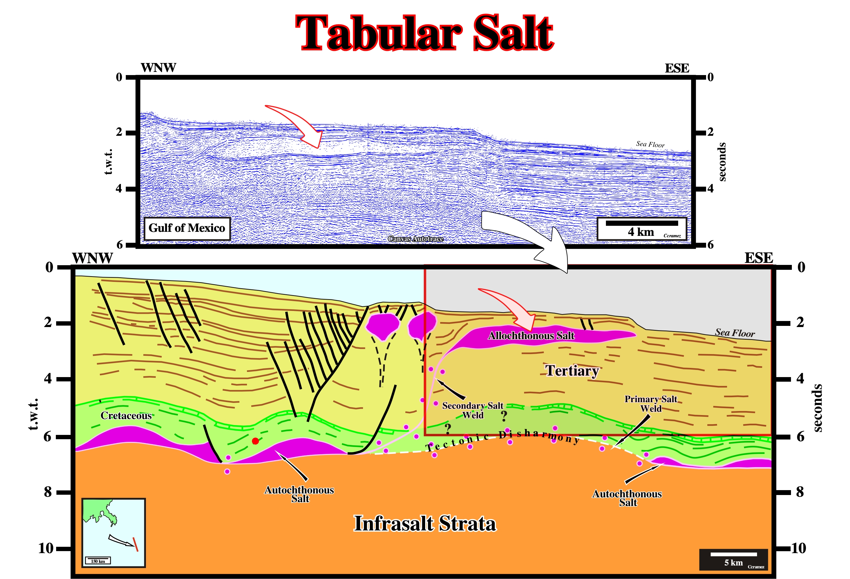
On this tentative geological interpretation of a Canvas autotrace of a GOM seismic line, the geometry of the southern allochthonous salt is that of a tabular salt body.
Tabular Salt Mini-Basin Province (Diegel, F. A. et al, 1995)
Expression, used in Gulf of Mexico, to refer to extensive salt sheets with intervening deep-water sediment-filled mini-basins.
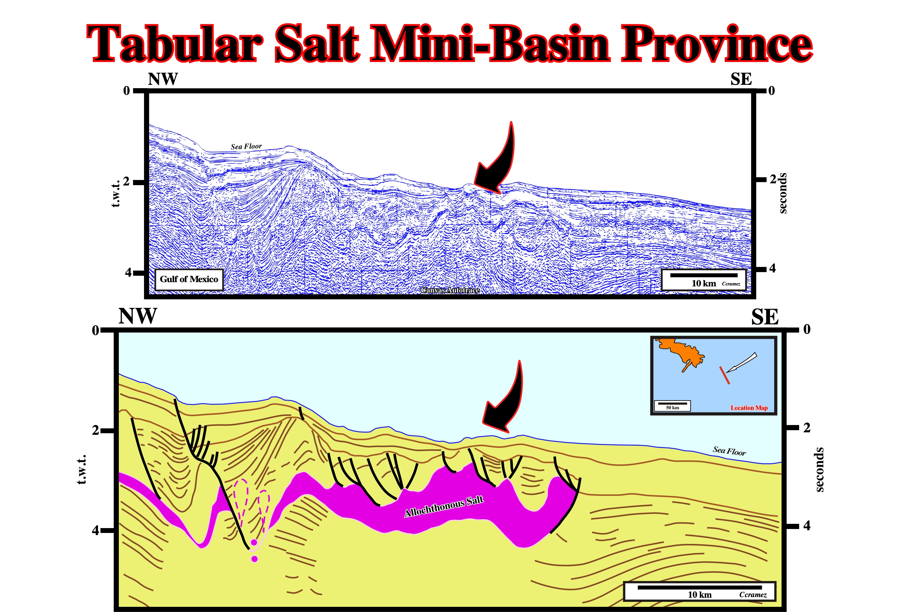
Taking into account that the above Canvas autotrace is in time and not in depth, it is quite credible that the true geometry of the bottom of the allochthonous salt is roughly tabular. It is for this reason that several geoscientist working on Gulf of Mexico call similar areas tabular salt mini-basin provinces.
Tachyhydrite
A yellowish mineral: CaMg2Cl6.12H2O.
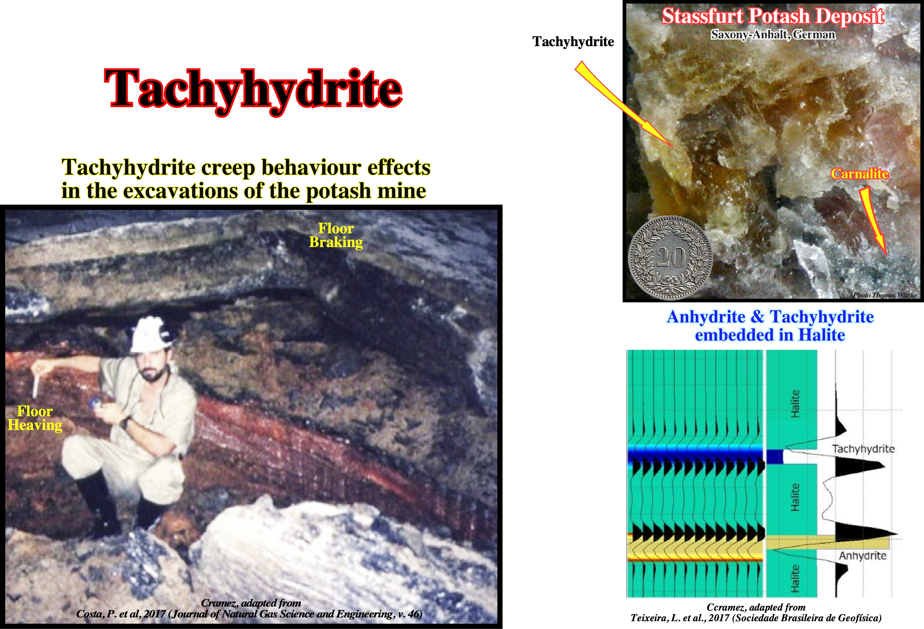
In Brazil offshore subsalt strata reservoirs are located under high water depth. Such a reservoirs rocks are, mainly, carbonates formed by microbiolite, coquina, volcanoclastic, with vertical and lateral heterogeneity. The fluid in these rocks may vary from low to high CO2 content with large differences related to gas-oil ratio. To reach these reservoir and evaporitic section up to 3000 m must be drilled. The evaporites under high pressure the overburden impose drilling challenges, since they have a mobile nature affecting well bore stability. The creep behaviour of salt rock can lead to hole closure and borehole collapse. So the salt characteristics mus be perfectly known to avoid surprises. Salt mineralogy is an important information when drilling th rough evaporite rocks. Chlorite and sulphate salts, such as tachyhydrite (CaCl2.2MgCl2.12H2O) and carnalite (KCl.MgCl2.6H2O), have a higher creep strain rate when comparing to halite (NaCl). Tachyhydrite has two orders of magnitude creep strain rate than halite. When intercalation of mobile rocks occurs in the thick layers of halite, many operation problems have been reported as stuck pipe and collapse borehole (Costa et al., 2010). Anhydrite (CaSO4) is found among evaporite rock but it is considered as immobile
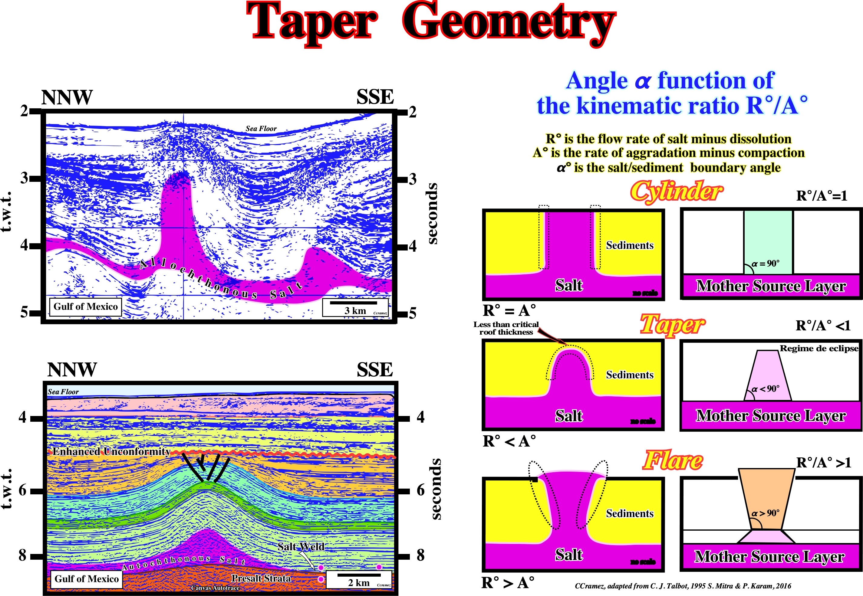
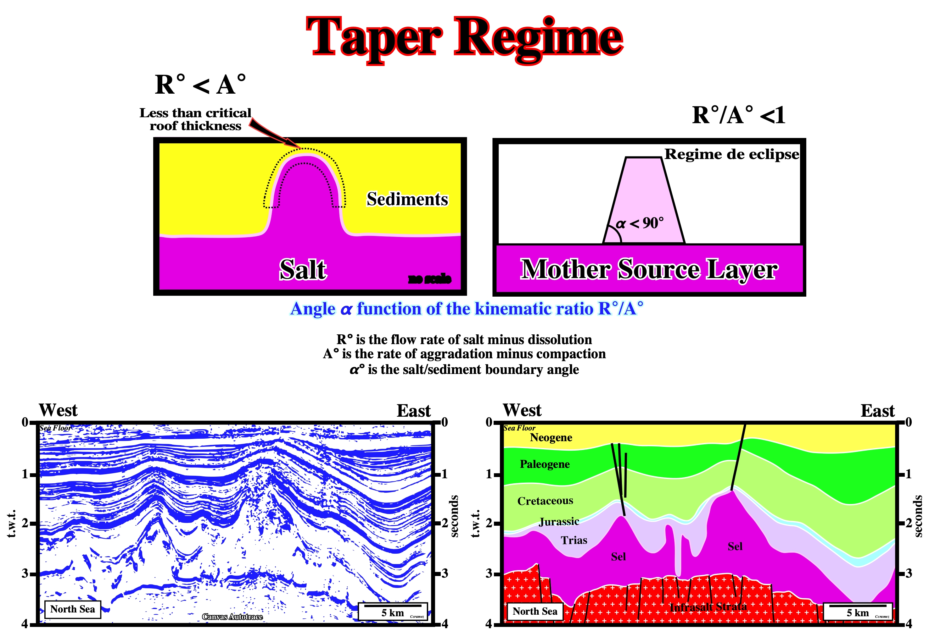
Taper Geometry (Talbot, C. J., 1995)
When the net rate R°/A°<1 (flow rate of salt minus dissolution / rate of aggradation minus compaction) and the top salt contacts are molded such that they converge upward (molding models).
A taper geometry, which develops, mainly, when the net rate R°/A°< 1, i.e., when α° is lower that 90°, can be recognized on the above preliminary tentative geological interpretations of Canvas autotraces. Do not forget that R° is the flow rate of the salt minus dissolution and A° is the rate of aggradation minus compaction and α° is the salt/sediments boundary angle.
Tapering Regime (Talbot, C. J., 1995)
When molded salt contacts are overstepped by overburden.
This tentative geological interpretation of a Canvas autotrace of a North Sea seismic line illustrates a tapering regime of the evaporites (mainly salt), in which the salt / sediments boundary angle is always lower than 90°. The occurrence of a lot of deformed seismic reflections within the salt, strongly suggest, the salt is not just a massif salt but a salt (halite) interbedded with other evaporites as carnalite, sylvite or tachyhydrite or with other rocks. Such a feature must be taken into account during the drilling, since in the area where the original seismic line was shot, the main reservoir-rock is in the subsalt strata (Rotliegend formation).
Tectonic Disharmony
Geological surface individualizing two realms of deformation. Tectonic disharmonies are often associated with a mobile substratum whether salt or shale.
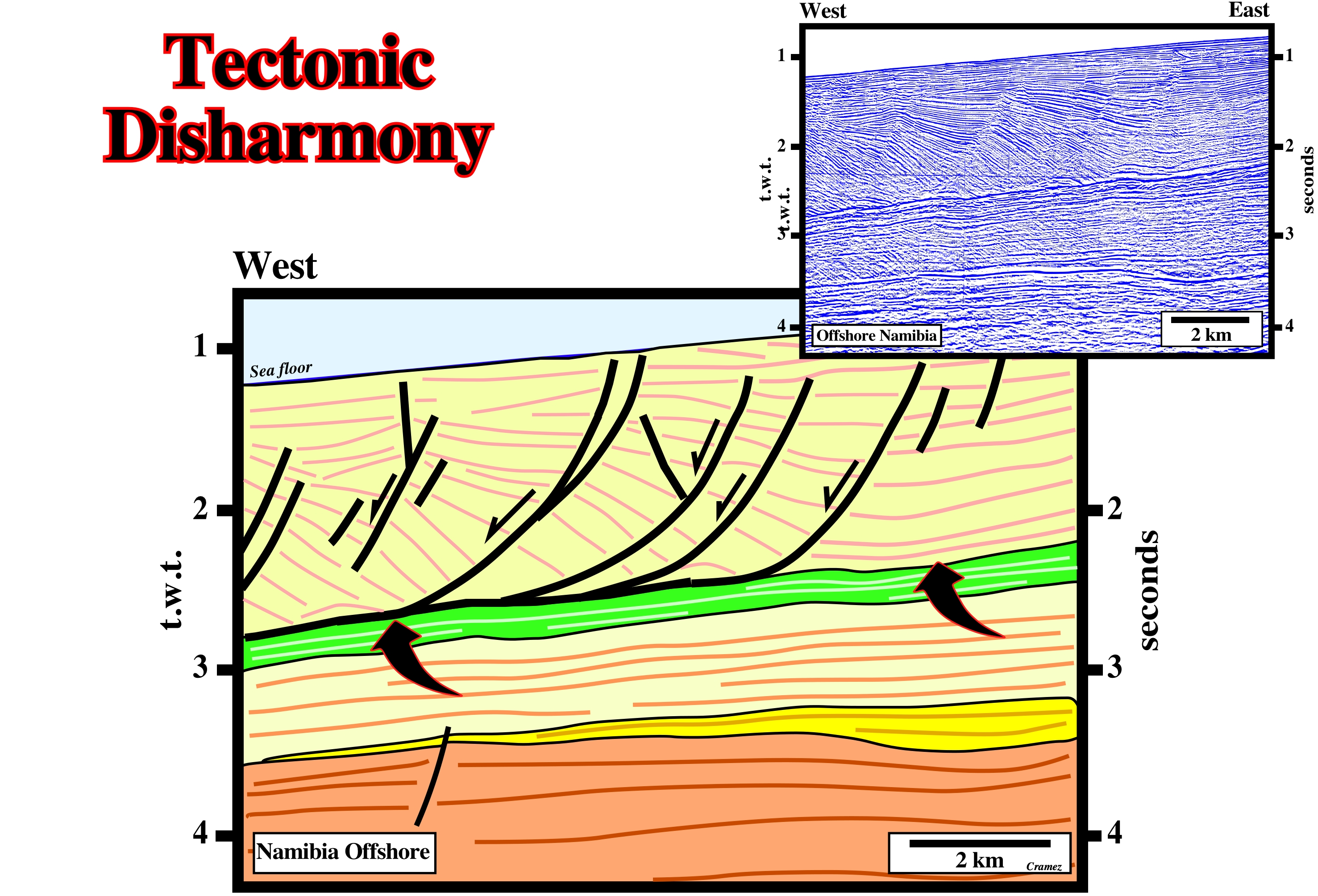
The tectonic disharmony, illustrated on this preliminary tentative geological interpretation of a Canvas autotrace of a Namibia offshore seismic line, seems induced by a thin shale layer (there is any salt layer south of Angola offshore). The sediments overlying the shale induced tectonic disharmony were lengthened by an extensional tectonic regime, while the sediments below the disharmony are mainly undeformed.
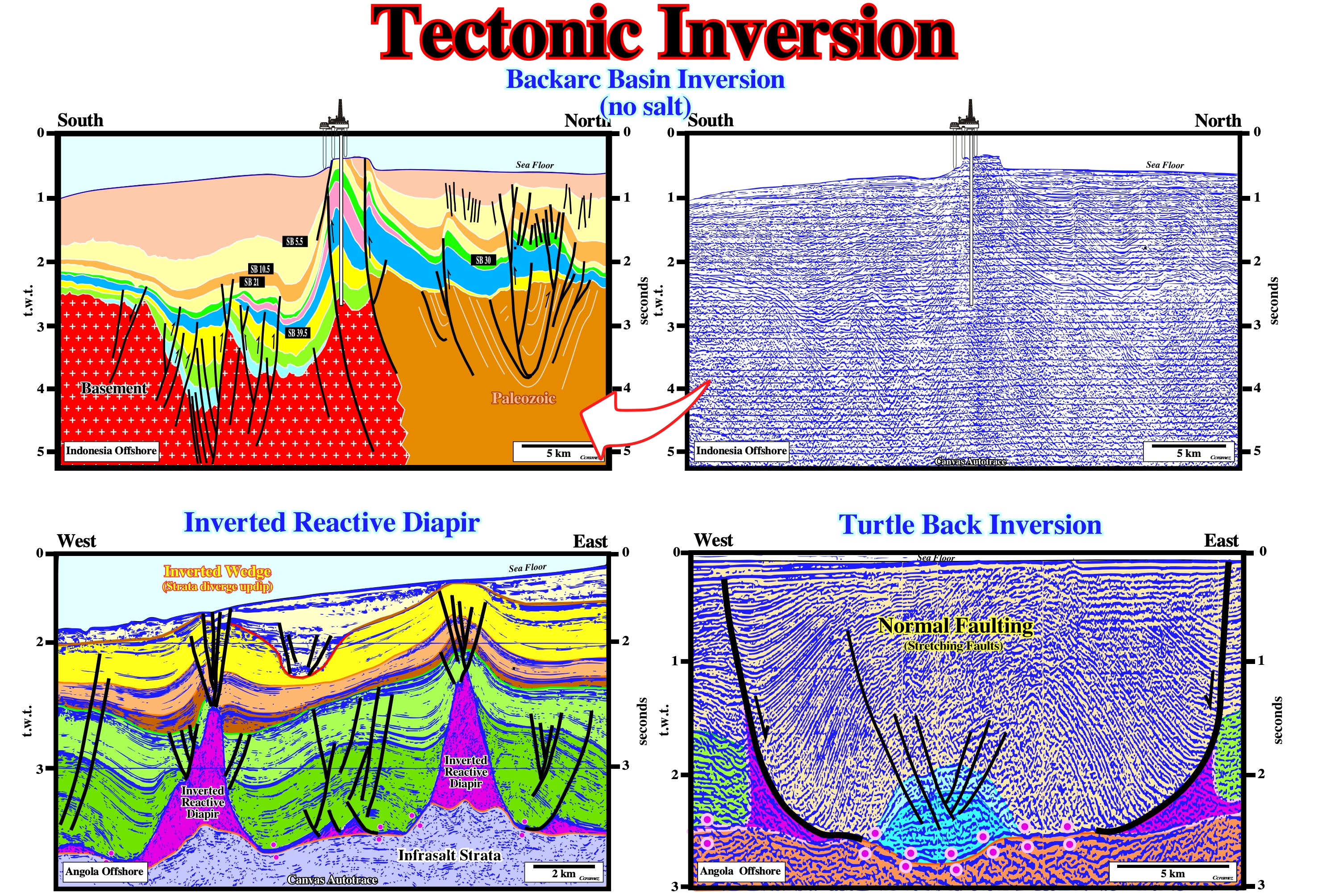
Tectonic Inversion
See: Structural Inversion
On these tentative interpretation, the volume problems, created during a compressional tectonic regime, were solved by folding and reactivation of the pre-existent normal faults as reverse faults. The normal faults developed during the rifting phase of a back-arc basin during which an extensional tectonic regime was prevalent. In the northern part of Indonesia offshore Canvas autotrace, the reactivation of the pre-existent normal faults is quite important. The pristine normal geometry changed to reverse. Contrariwise, in the southern part, the reactivation is less important. The geometry of the reactivated reverse faults still is normal. As fault reactivation depends (i) on the angle between σ1 of the compressional tectonic regime and the strike of the fault, and (ii) the angle between σ1 and the dip of the fault, it is possible to put forward the claim that the strike of the faults in the southern part of the line is different from the strike of the faults located in the northern area, i.e. two faults systems are visible on the line. The tectonic inversions of the depocenters in the overburden associated with diapir reductions are well know in offshore Angola. Actually, when on a seismic line, a depocenter, i.e., a convergent thickening interval, overlying a salt diapir, is in a high structural position, interpreters must hypothesise a tectonic inversion induced by a local, or regional, compressional tectonic regime.
Tectonic Stress (σt)
Stress created by the displacement of lithospheric plates. Tectonic stress is a vector acting parallel to the surface of the geoid.
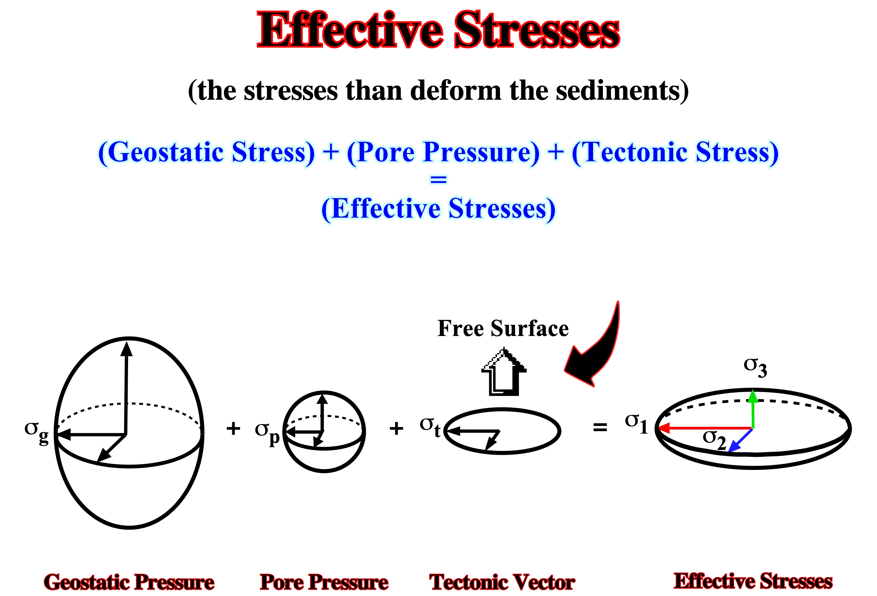
As illustrated above, it is not the tectonic stress (σt) that is the responsible for deformation, but the effective stresses, i.e., the sum of geostatic pressure, hydrostatic pressure and tectonic pressure. Actually, with a tectonic stress positive, the sediments can be lengthened (σ1 vertical) or shortened (σ1 horizontal).
Tectonic Subsidence
Subsidence of the basement. It contrasts with the compensatory subsidence induced by salt flowage, in which the basement stays inactive. Tectonic subsidence curves are constructed by plotting the depth of an horizon, preferably the top of the basement at a series of ages through time. Such plots show the burial history of the plotted horizon. If the paleowater is included for each age-depth pair the plot shows total subsidence. When the total subsidence curve is corrected for local isostatic compensation and sediment compaction, the result is a tectonic subsidence curve. this curve shows the water loaded hole that tectonic can create if no sediments were deposited. This curve is used for calculating rates and magnitudes of tectonic subsidence.
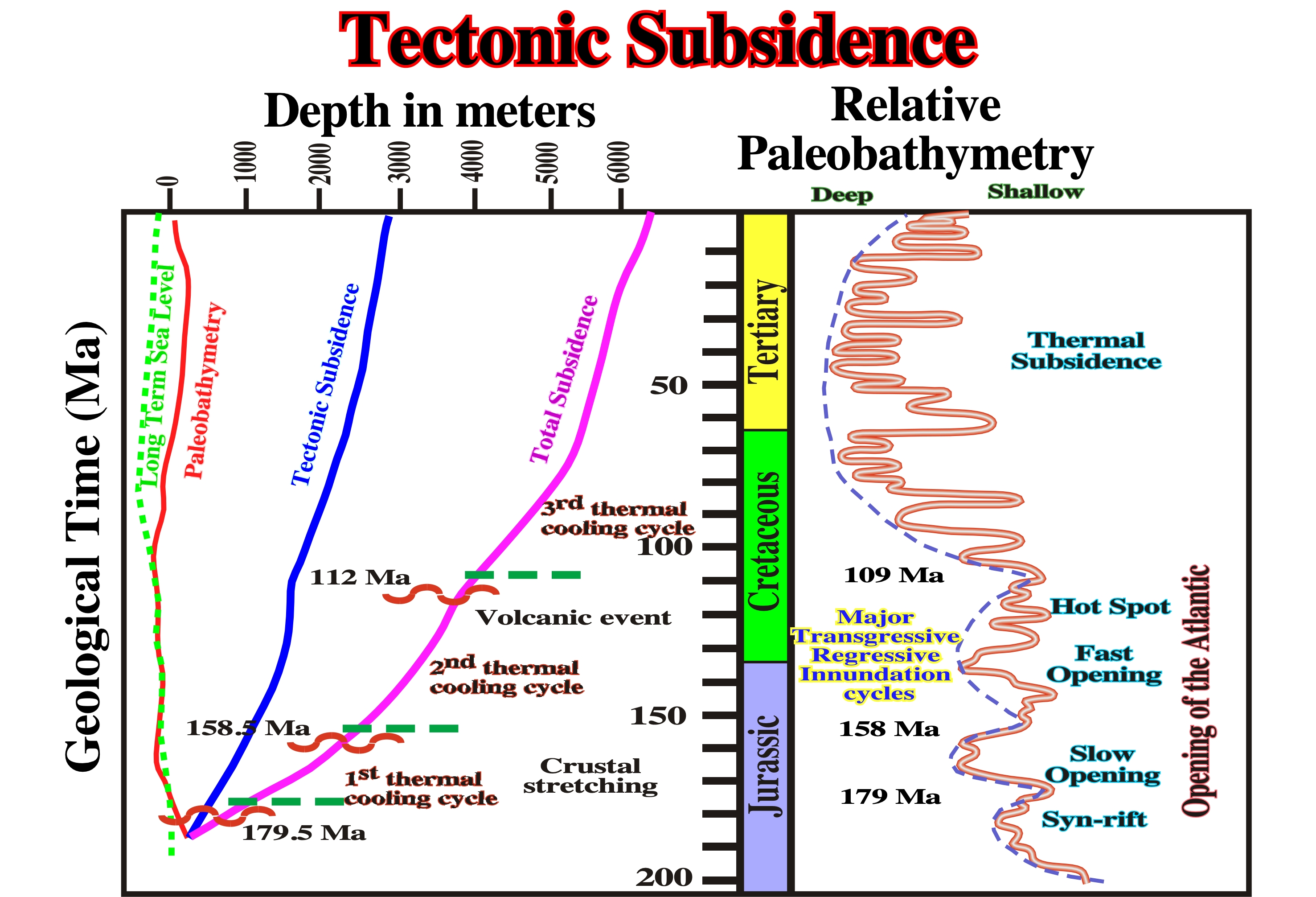
Among the stratigraphic and tectonic events associated with the opening of the North Atlantic proposed by Greenlee (1989), tectonic subsidence and total subsidence are determinant.
Tertiary Peripheral Sink
Peripheral sink that accumulates around a mature diapir that has exhausted the salt supply from its precursors pillow and is rising by necking or thinning of the diapir's stem. Coeval strata thin over the crest of the salt diapir.
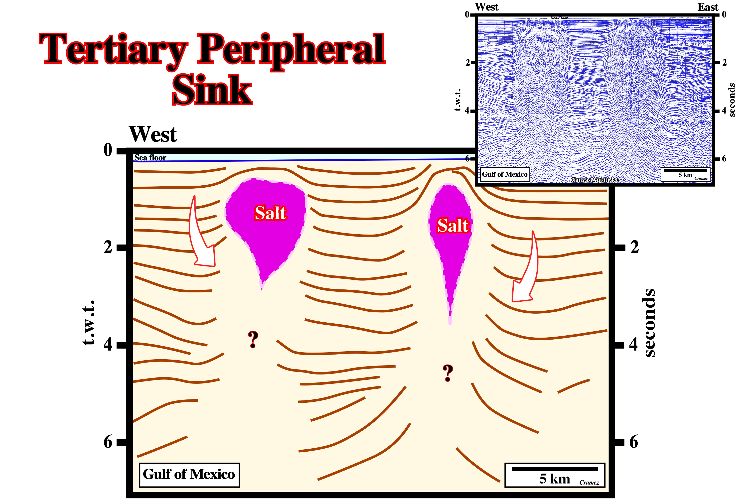
These peripheral sinks thin over the crest of the salt stocks. They are, completely, disconnected from the mother salt layer. A secondary salt weld can be predicted between the salt stocks and autochthonous salt layer (?).
Tertiary Salt Weld
Salt weld joining strata originally separated by gently dipping allochthonous salt sheets.
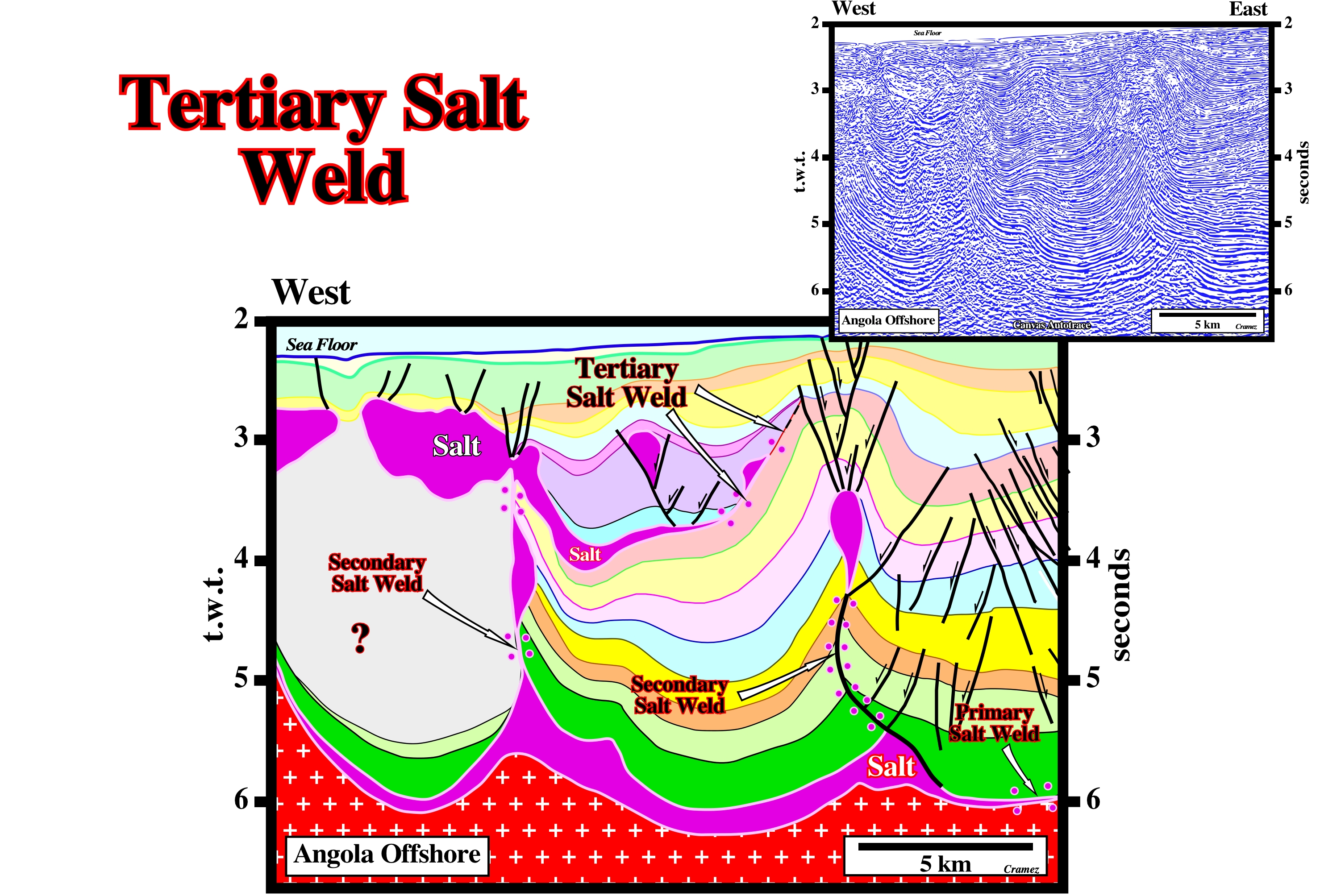
A tertiary salt weld can be recognized near the eastern end of the allochthonous salt. At such a level, a salt-induced tectonic disharmony can be recognized using the geometrical relationships between the seismic marker above and below the weld.
Thalassocraton (Bates, R. L. and Jackson, J. A., 1980)
A craton that is part of the oceanic crust. It is the English version of Tiefkraton (Stille, 1940) and a synonym of hedreocraton.
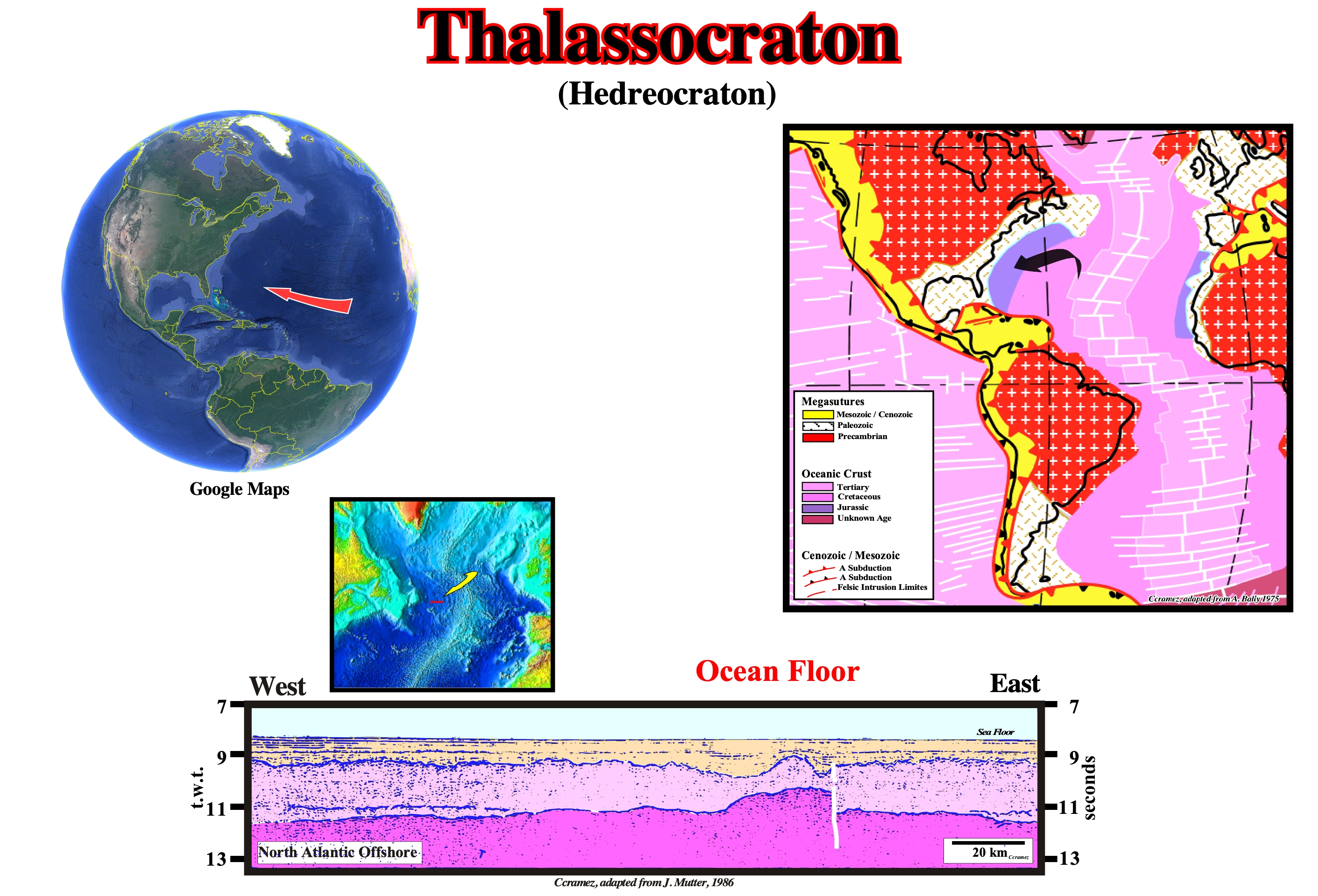
Thalassocraton is a tectonically, relatively, stable and level area of the ocean floor. The term was introduced by the Australian geologist R. Fairbridge in 1955 in connection with the beginning of the study of the geology of the oceans. With the discovery in the 1960’s and 1970’s of the worldwide system of mid-ocean ridges, which are, tectonically, active (mobile) belts of the ocean floor, it became obvious thalassocratons cannot include these ridges. Therefore, some researchers gave other names, such as “ocean plates” or “thalassoplains,” to the relatively stable sectors of ocean bottom outside the boundaries of the mid-ocean ridges. In the framework of the new global tectonics, or plate tectonics, thalassocratons are parts of the plates of the lithosphere. As the Greek roots of the term imply, morphotectonics (form, plus building) refers to the structural foundations of geomorphology. Kober (1928, p. 23) used it to cover the gross and major relief features of the earth. In the first order there is the distinction between continents (“epeirogenic”) and ocean basins (“oceanogenic”). For the same features the writer has emphasized the crustal differences, thus epeirocraton and thalassocraton (Fairbridge, 1955). In any case, the relief contrast is statistically proven by the bimodality of the hypsographic curve (q.v.), and the geophysical contrast between the 30-50 km thick continental crust and the 5 km thick oceanic crust is now well known. Mean altitudes of continents show a statistically close relationship to areas, if due allowance is made for ice-covered areas (Matschinski, 1952). On this tentative geological interpretation of a Canvas autotrace of a seismic line from the North Atlantic offshore, the abyssal sediments, with parallel geometry, and the interface between these sediments and the oceanic crust is well recognized. The oceanic crust does not show many reflections. It is possible to see at about 11 - 12 seconds deep time a marker, more or less, continuous, that several geoscientists associate with the Mohorovi?i?’s discontinuity. This marker (Moho), like elsewhere the top of the oceanic crust are moved vertically. This displacement is known as the Black Spur fracture zone.
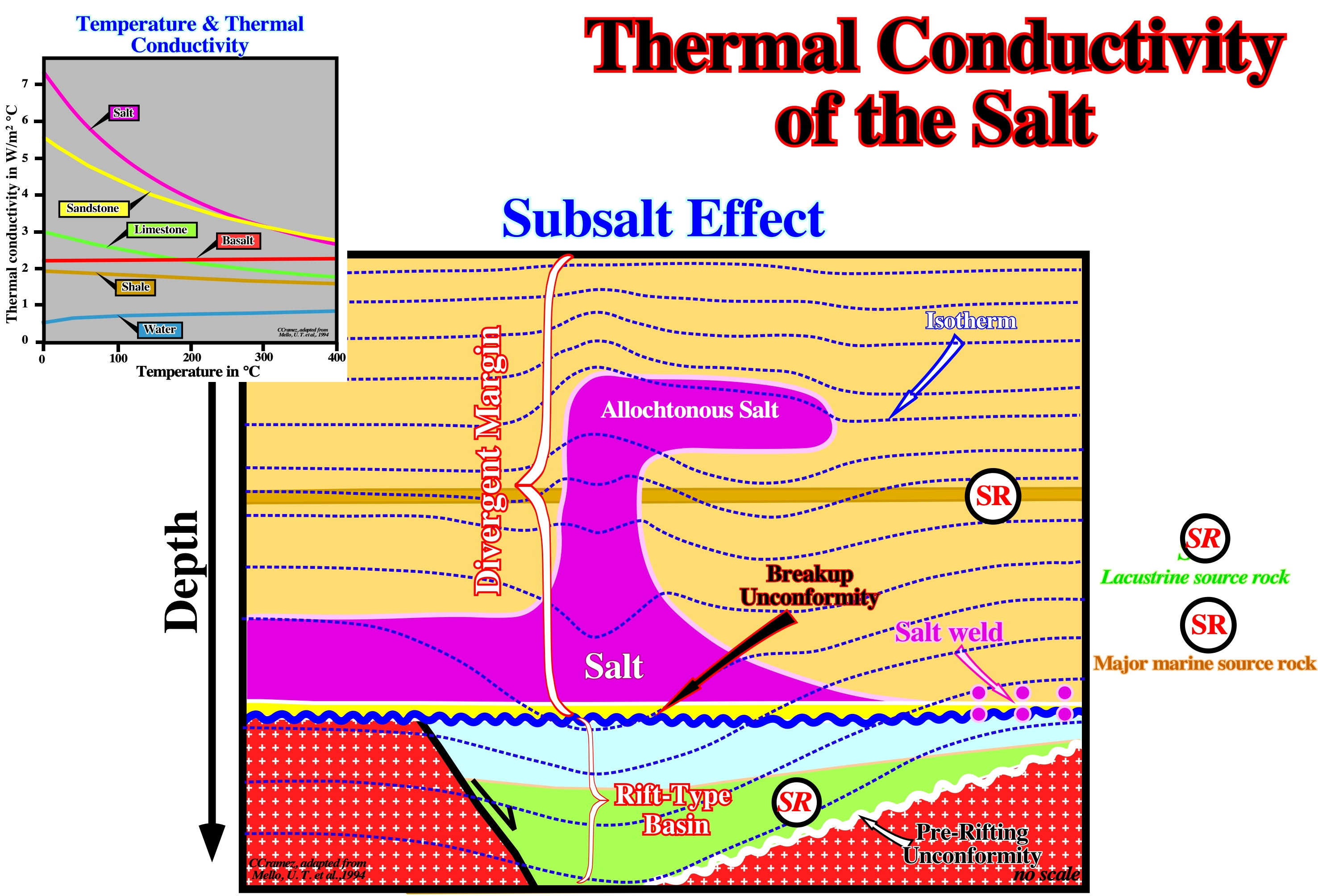
Thermal Conductivity of the Salt
Thermal conductivity of the salt (halite) is around 5-6 W 1/m 1/K, i.e., higher than in shales (1-3) and sandstones (2-5), which is quite important for the maturation of the organic matter. In fact, the understanding of the time and place of maturation of source-rocks for petroleum generation requires an understanding of past geothermal gradient, which we have to estimate, since we can't go back in time to measure those geothermal gradients. Attempts to estimate past geothermal gradients commonly involve modelling of the flow of heat through layers of sedimentary rock.
If for you, the relationship between thermal conductivity and the geothermal gradient is not intuitively obvious, remember that when you take a hot item out of the oven, you want a low thermal gradient between that item and your hand (you want keep this item warm and your hand cold). To do that, you put a hot-pad (an insulator and thus an object with a small thermal conductivity) between the hot item and your hand to enforce the desired large thermal gradient (Railsback's Petroleum Geoscience and Subsurface Geology). The same happen in the ground, during maturation of the organic matter of the potential source-rocks, where salt layers play an important role, as illustrated above. On this sketch, due to the high thermal conductivity of the salt, the isotherms rise above and drop below a thicker salt. In other words, the maturation of the organic matter of rift-type basin sediments, covered by a thick salt layer, is slow down since the salt layer absorb a lot of heat (the isotherms go down), Conversely, the maturation of the organic matter of potential source-rocks located above a a thicker salt is accelerated, since the salt transfer upward a lot of heart, i.e., the isotherms go upward as illustrated above the salt dome.
Thermal Convection
Rising of hotter salt and sinking of cooler salt as a result of a thermal gradient between the top and bottom of the convecting layers. A temperature-induced density inversion provides the necessary instability.
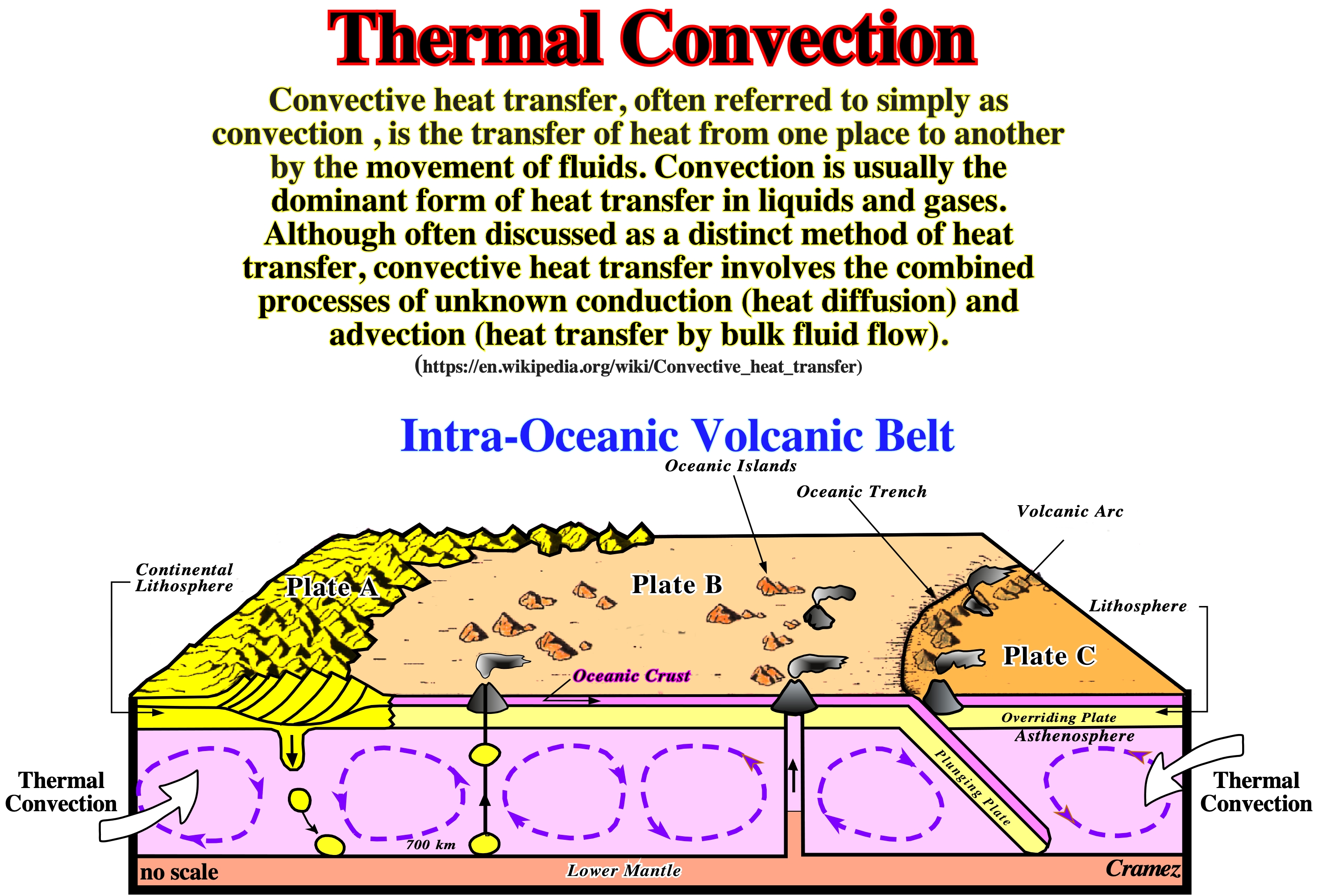
As depicted on theis geological skecht, thermal convection is at the base of Plate Tectonics paradigm.
Thin-Skinned Tectonics
Term used for the first time by Rodgers (1963) for an interpretation that folds and faults involve only the upper strata and lie on a décollement beneath which the structure differs. By extrapolation thin skinned tectonics is used to the study of the structural features deformation above a decollement.
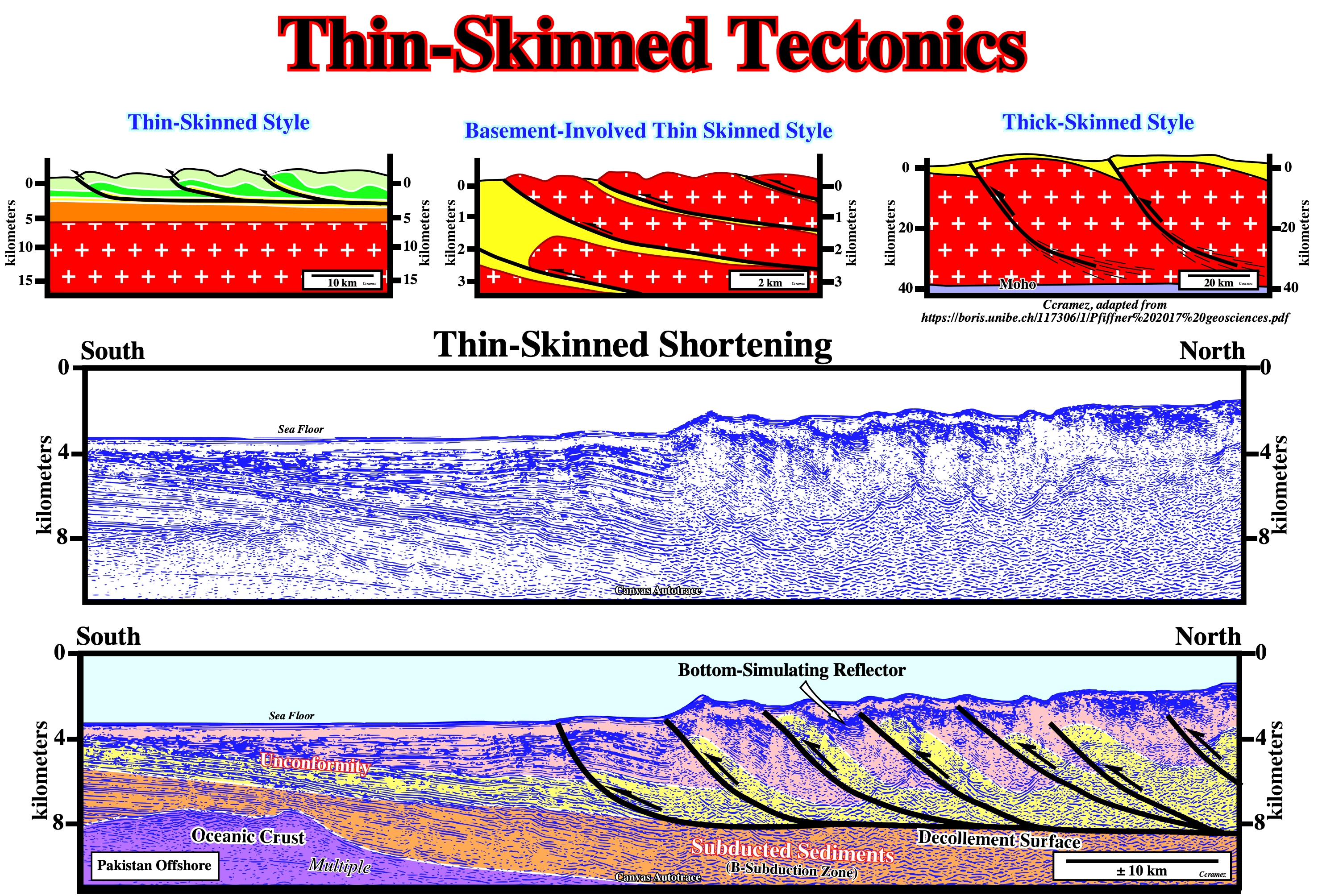
This preliminary tentative geological interpretation of a Canvas autotrace of a Pakistan offshore seismic line suggests a thin-skinned tectonics on the overriding lithospheric plate of the associated B-subduction zone.
Third Generation Diapir
Diapirs rising from second-generation salt sheets. Synonym of third-cycle Diapir
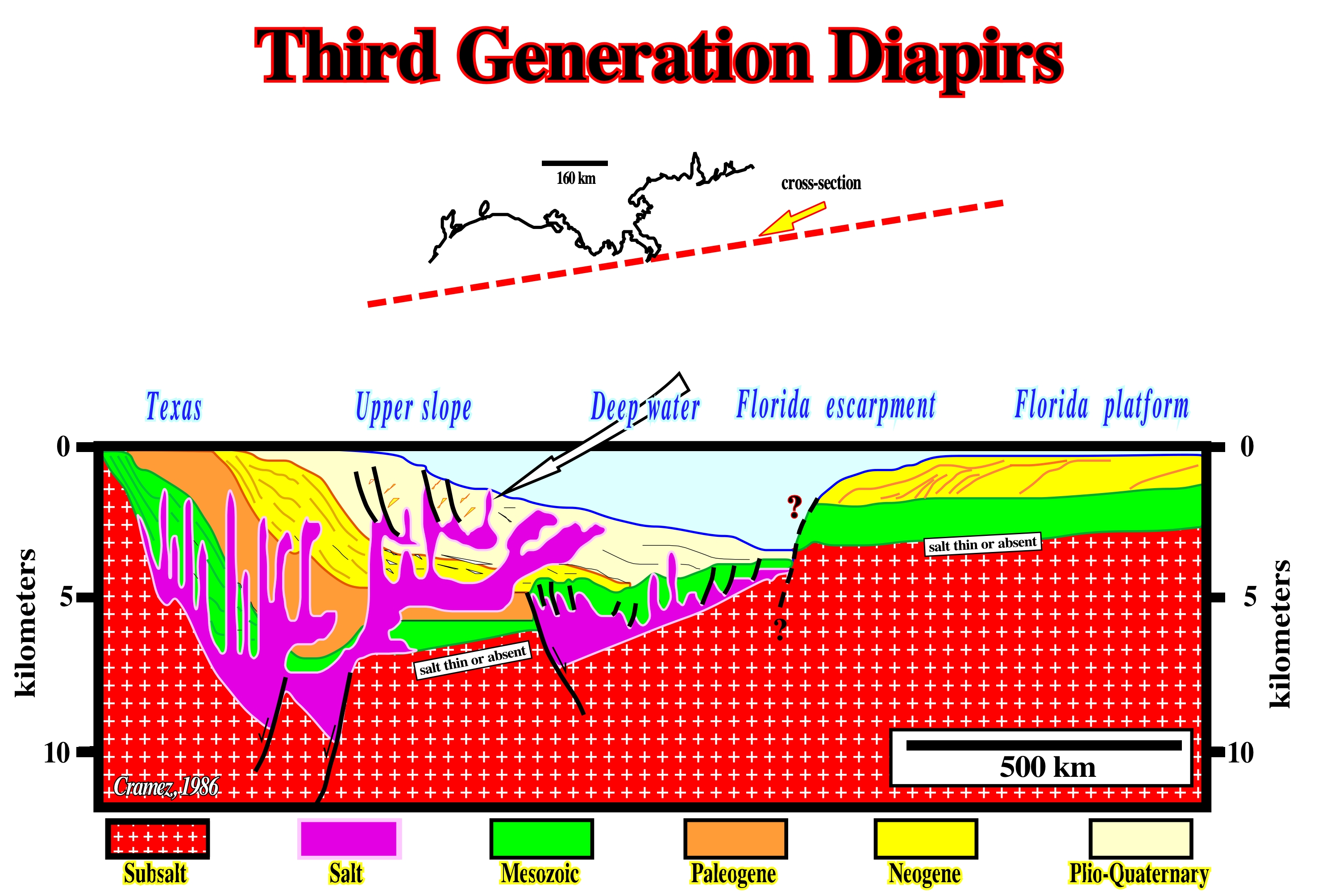
The next figure illustrates a long and vertically exaggerated geological cross-section between onshore Texas to Florida platform. It epitomizes the regional geological setting of the Gulf Coast and shows a lot of salt tectonics and halokinetic features. On the Florida platform, the Louan salt is thin and often absent. On the contrary, seaward, the salt thickness is important (quite exaggerated on the cross-section). The salt deformation can be recognized under different structural configurations. Geologically speaking, the Gulf Coast, between the Florida platform and the onshore Texas, corresponds to a Mesozoic Mediterranean-type basin (the oceanization of the Gulf of Mexico is no more a speculative hypothesis, but a likely one) overlain by Neogene Atlantic type divergent margin. The two graben-like structures filled by salt are speculative. They correspond to an old geological hypothesis that so far has not been verified and corroborated either. Certain geophysical data seems refute it.
Third-Order Cell
Cell affecting only part of a single diapir, as in the growth of mushroom diapir bulbs.
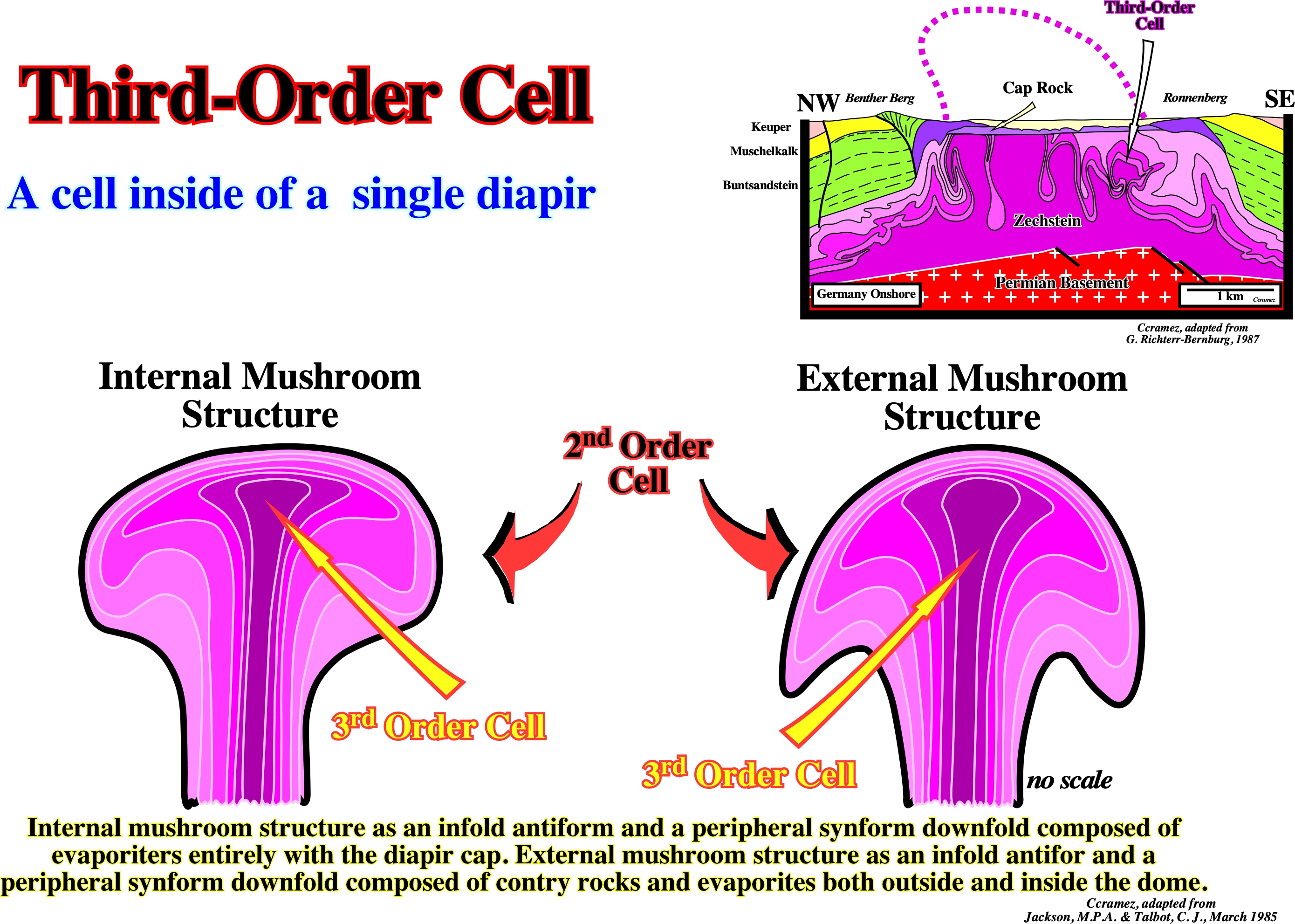
Third-order salt cells, with single diapirs are recognized in the field, as illustrate on the cross section of a Germany offshore salt diapir, and in the centrifuge models.
Thrust-Fault (McNeill, L. et al., 1999)
A fault with a dip of 45° or less over much of its extension, on which the hangingwall appears to have moved upward relatively to footwall. Horizontal compression rather than vertical displacement is its characteristic feature.
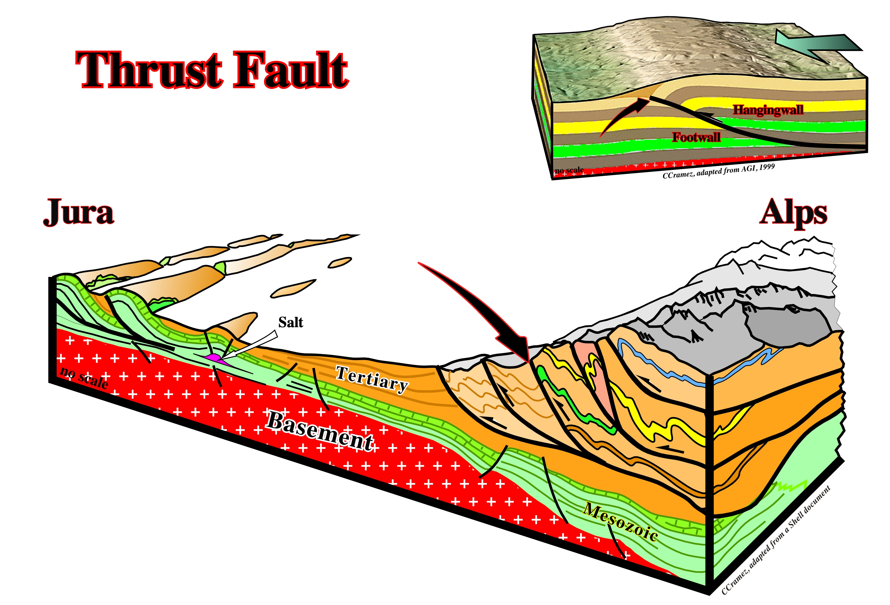
Thrust faults are created by compressional tectonic regimes with σ1 horizontal and σ3 vertical. Cylindrical-folds, striking parallel to the fault plan, develop in the hangingwall.
Transform-Fault
A strike-slip fault linking two spreanding centers in a mid-oceanic ridge.
![]()
As illustrated on this map, transform faults are limited by mid-oceanic ridge segments. Beyond the mid-oceanic ridges there are no movement, therefore they are not active faults but just fracture zones.
Transgressive Interval
Synonym of backstepping or retrogradational interval.
![]()
On this tentative geological interpretation of a Canvas autotrace of a Labrador Sea seismic line, within a sequence-cycle, induced by a 3rd order eustatic cycle, whose time-duration varies between 0.5 My and 3.5 My, the transgressive interval (TI), which certain geoscientists call, inappropriately, transgressive systems tract is, easily, recognized between the lower unconformity of the sequence-cycle and the highstand prograding wedge (HPW). The reflectors of the underlying sequence-cycle are represented by thick, white traces, while those of the transgressive interval (TI) are coloured in green. The reflectors of the transgressive interval (TI) rest by coastal onlaps against the reflectors of the underlying sequence-cycle emphasizing an unconformity (erosional surface). Within the transgressive interval, the presence of four ravinment surfaces is observed and, between them, the reflectors progradate seaward. The transgressive interval, in its entirety, corresponds to the transgressions of C. Emiliani (1992), i.e., to a set of increasingly important marine ingressions (relative sea level rises) and increasingly smaller sedimentary regressions, which, creates, globally, a retrogradational geometry. The relative sea level is a local sea level, referenced at any point on the Earth's surface, which can be the sea floor or the base of the sediments (top of the continental crust) and which is the result of the combined action of the tectonics (subsidence or uplift of the sea floor) and the absolute (eustatic) sea level, which is supposed to be global and referenced to the Earth' centre of the Earth. As can be seen on this tentative interpretation, as well as in the geological model, since the first relative sea level rise, which floods the preexisting topography, the shoreline (more or less the depositional coastal break of the depositional surface) is displaced landward (marine ingression), creating on the deposited sediments, a ravinment surface. At the same time, a water-depth is created (development of the shelf within the sequence-cycle) and available space for the sediments (accommodation). During the stability period of relative sea level, which follows the marine ingression, the transported sedimentary particles, gradually, deposit in progradational sedimentary packages (sequence-paracycle) moving the shoreline, progressively, seaward, but without reaching its previous position. A shelf is thus initiated, between the continental edge and the new shoreline. A more important marine ingression than the previous one, again, shifts landward the depositional coastal break of the depositional surface, creating a new ravinment surface and increasing, again, the space available for the sediments. At the same time, lowstand geological conditions with a low sedimentation rate, are developed in the distal part of the platform (near the continental edge). More sediments will be deposit during the new stability period, in progradational packages, but, as before, the shoreline does not reach the extreme position it had before this relative sea level rise. New marine ingression, even more important, etc., etc. This geological history is repeated several times, until, finally, the new marine ingression is smaller than the previous one, i.e., until a relative sea level rise is deceleration, what starts the deposition of the highstand prograding wedge (HPW), during the stability period of relative sea level, as the shoreline begins to move, progressively, seaward diminishing the extension of the continental platform (shelf). It is important not to forget that a marine ingression reduces the Earth's albedo (ratio of reflected light energy to incident light energy), since the sea surface absorbs more solar radiation than the Earth's surface. Thus, probably, the temperature gradient between low and high latitudes is reduced during large marine ingressions. Some of this reduction is attributed to the increase of the CO2 content in the atmosphere, increased volcanic activity along the mid-ocean ridges, and increased organic productivity. On the contrary, a marine ingression contributes to the deposition of fossil-rich marine sediments on the continent, which means that sedimentary regressions interrupt the marine sedimentation on the continent, at same time, as erosion reduces the sedimentary deposits, previously, settle down, which implies that the continuity of marine records in a given region of the continent, rarely, exceeds a few tens of millions of years. Thus a Phanerozoic continuous record can, just, be reconstructed correlating and joining different stratigraphic sections.
Transitional Salt (Red Sea) (Heaton et al., 1995)
The offshore evaporites, in Red Sea, which exact age is unknown and where the structure and composition of the underlying crust is also unknown.
![]()
As illustrated on this geological cross section of Onshore Sudan (based on tentative geological interpretations of onshore and offshore seismic lines), the age of the massif salt, under great deep water, is, practically, unknown. It is this salt that certain geoscientists call transitional salt. In conventional offshore (water depth less than 200 meters), above the massif salt, without seismic reflections associated, there is a significant interval, often, called interbedded salt, which correspond to a quite deformed interstratification of salt and clastic sediments. Such a deformation is mainly due to halokinesis.
Translation Onlap Surfaces
Translation of the overburden across a stepped salt detachment (thin salt) bends the post-salt sediments and can create apparent translation downlap surfaces (gliding onlaps) in the synkinematic layers.
![]()
The apparent downlap surface created by translation of the overburden across a single emergent step, at the bottom of the salt, recognized on this tentative interpretation, is quite characteristic. In spite of the fact that the apparent downlap surface is, directly, associated with a salt step, its genesis is quite different of a salt weld.
Trap
Any barrier to the upward movement of hydrocarbons allowing to accumulate. A trap includes a reservoir rock and an overlying, lateral or updip impermeable rock, that is to say, a seal.
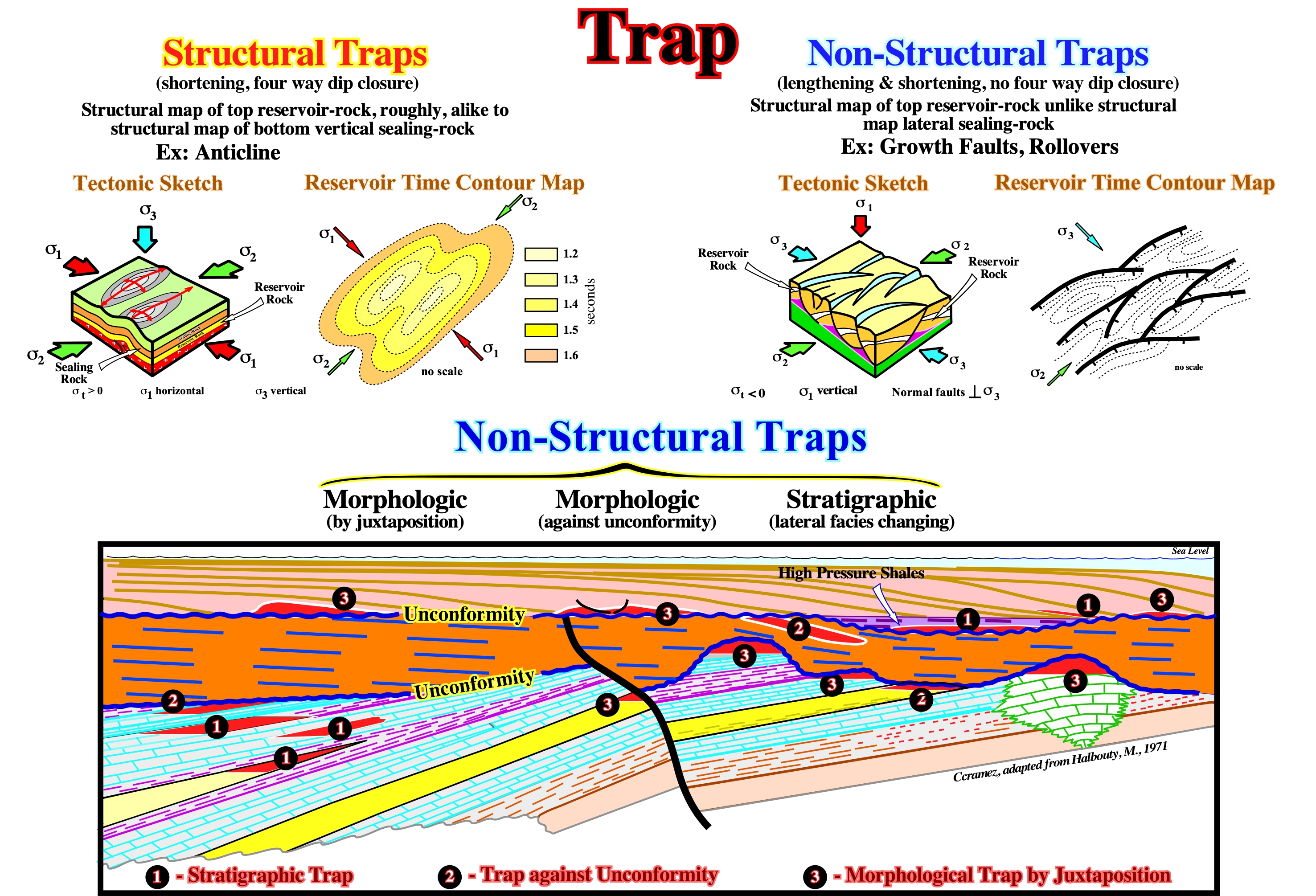
This sketch summarize the main non-structural traps, wjhich can be : (i) Stratigraphic ; (ii) Against unconformity and (iii) Morphologic by juxtaposition.
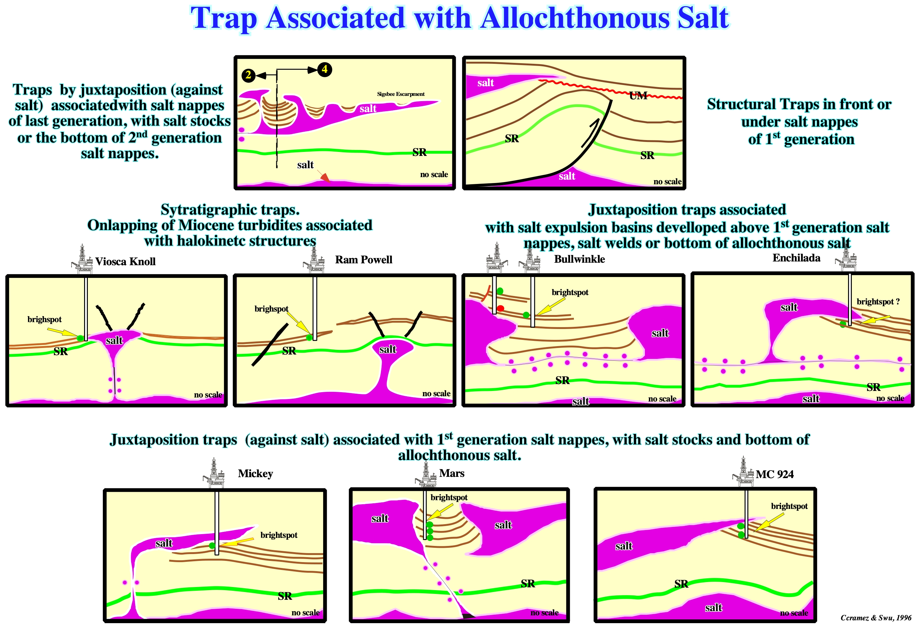
In this skectch are illustrated the main traps associated with allochthouonous salt in Gulf of Mexico.
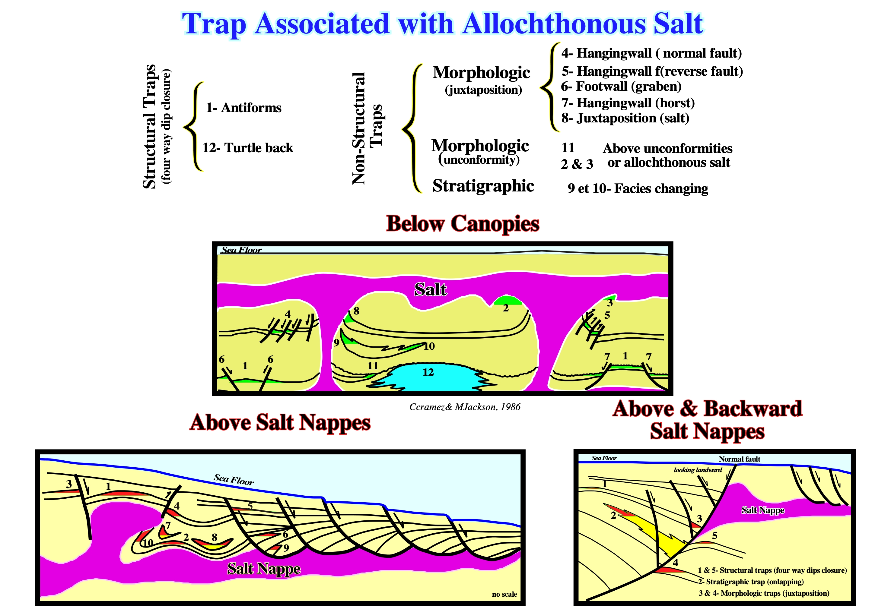
In these sketches the main traps located below canopies, above salt nappes and below and backward salt nappes are illustrated. The number in each traps indicated the type of traps: (i) Structural traps (four way dips) n°1 and 12 ; (ii) Traps by juxtaposition (non structural traps) between n°4 and n° 8 ; (iii) Morphologic traps (non structural traps) n ° 11 and n° 3 and (iv) Stratigraphic traps (non structural traps) n° 9 and n° 10.
Triassic
The lower system of the Mesozoic erathem, above the Permian, of the Paleozoic era, and below the Jurassic.
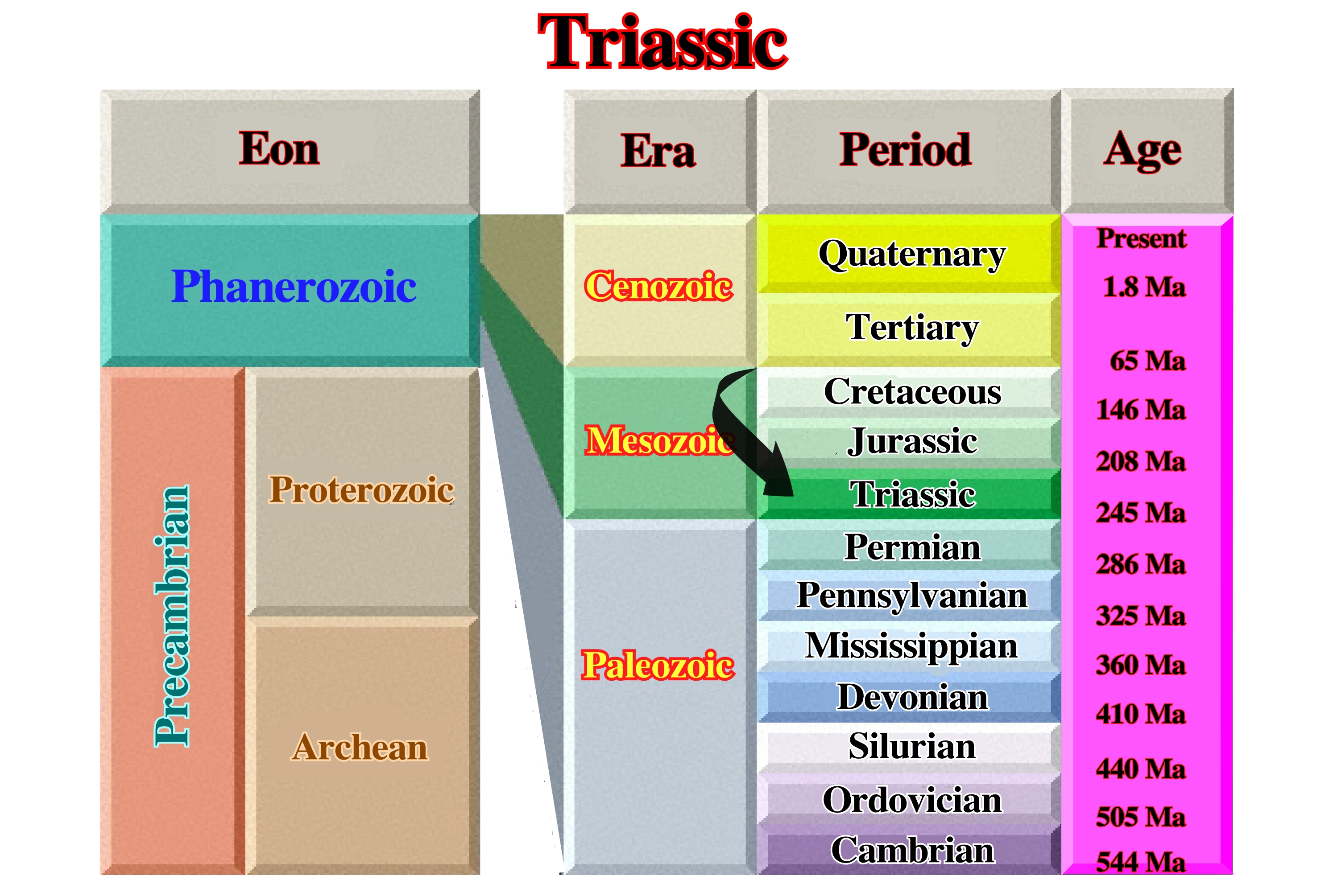
Triassic is also the time during which Triassic rocks were formed. The Triassic Period thought to have covered the span of time between 245 and 200-210 Ma.
Triaxial Ellipsoid
Ellipsoid with three different and orthogonal axes.
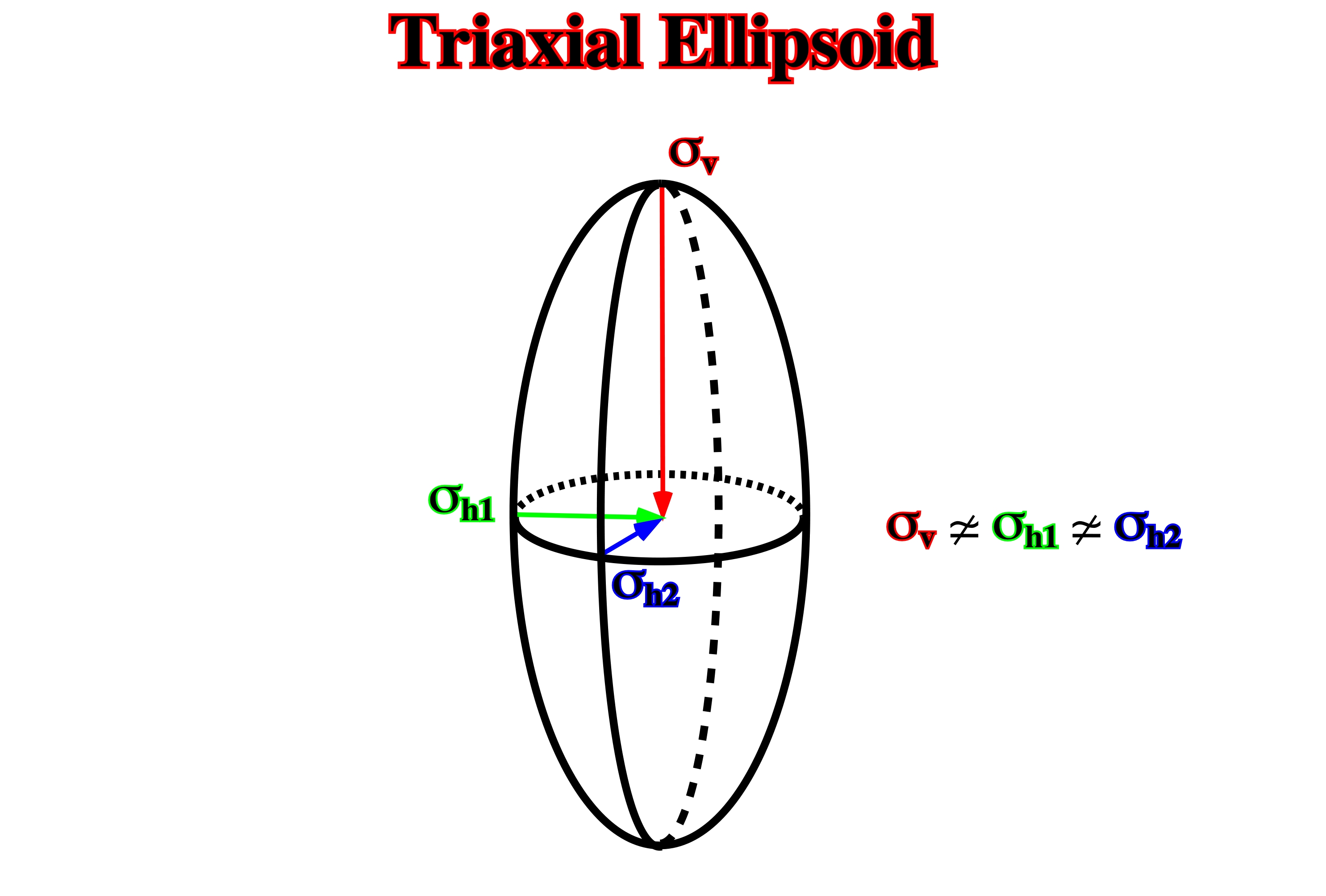
The majority of the tectonic regimes can be represented by triaxial ellipsoids. Only, the local tectonic regime associated with salt, shale domes and buried hills (differential compaction) are biaxial.
Trusheim's Salt Dome Model
Geological model proposed by Trusheim to explain certain salt structures without significant lengthening of the overburden, i.e., halokinetic structures.
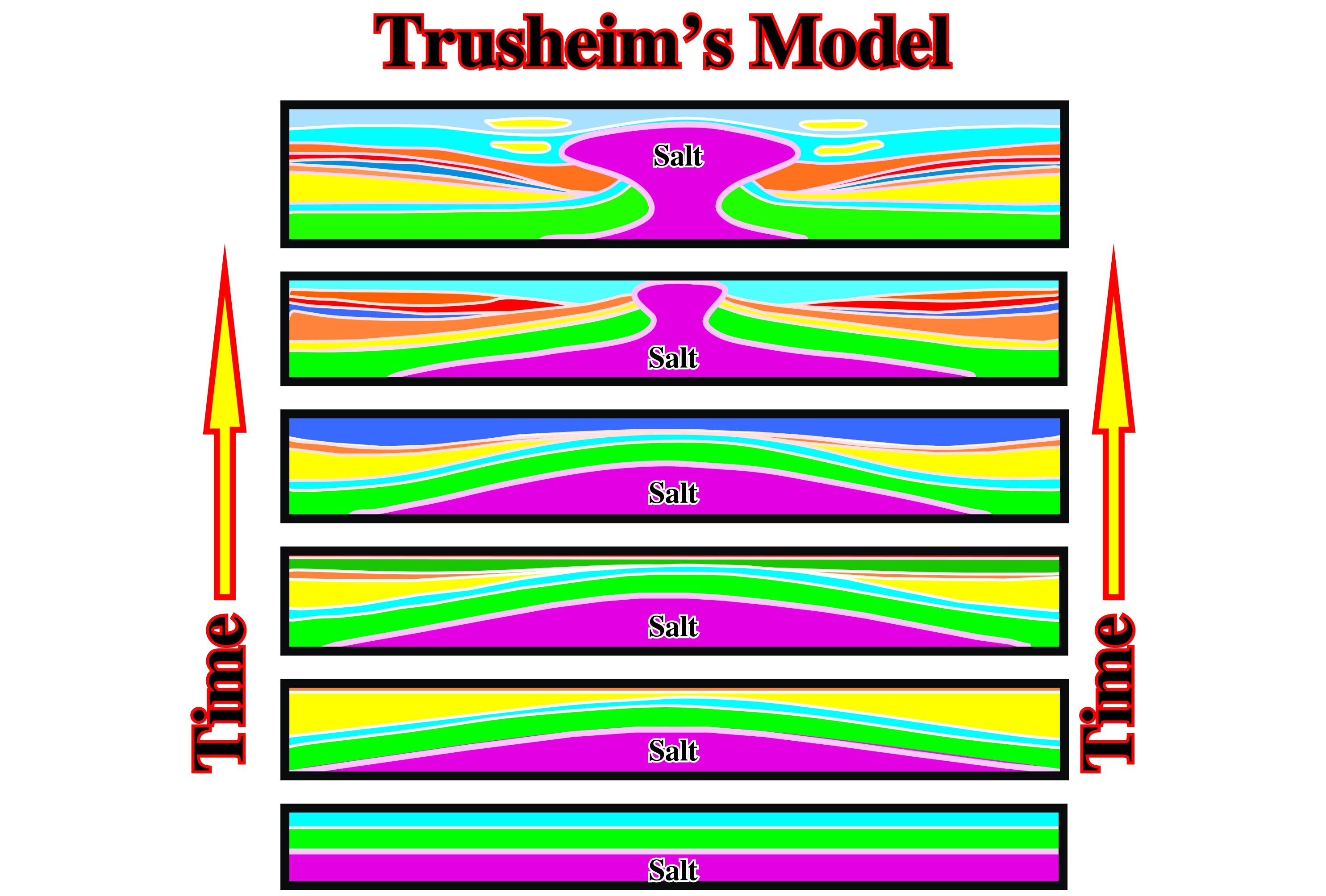
In the Trusheim's model, there is no extension and the amount of salt stays constant.
Turbidite Deposit
General term to express sediments deposited from, or inferred to have been deposited from, gravity currents.
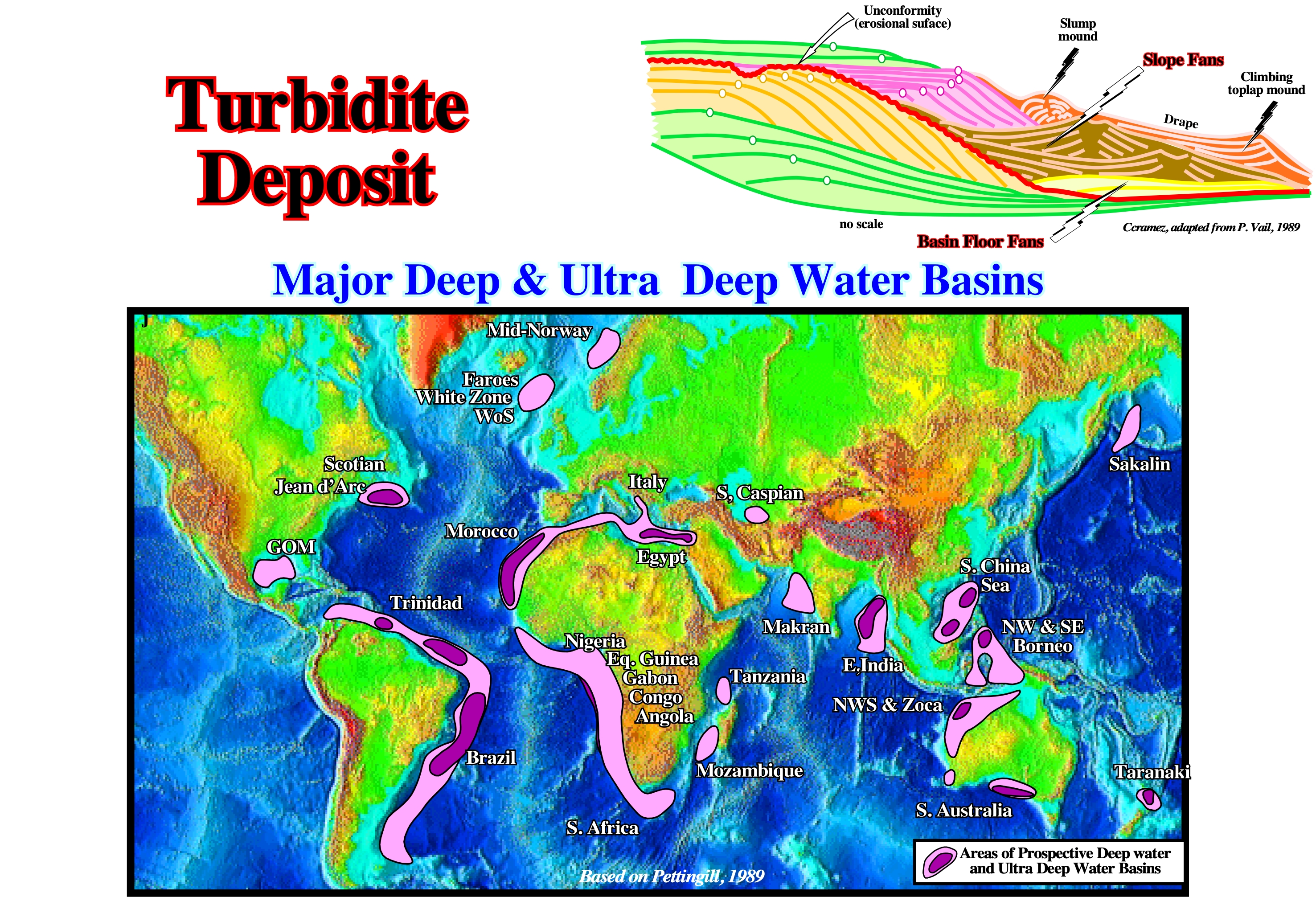
Several geological models have been invoked to explain marine turbidite depositional systems. Vail and Mutti's geological models are, by far, the most useful in petroleum exploration. In deep water (>500 meters), the recoverable resources announced in Brazil, West Africa, GOM and NW Australia include producing reserves, i.e. those in development, and technically recoverable resources for which development has not been sanctioned. All these resources are in Atlantic-type divergent margins. However, the resources found in Mid-Norway (Ormen Lange) 11 TCF & 34 MMBC, Egypt (Scarab-Saffron) 4.5 TCF and Philippines (Malampaya) 3.5 TCF, strongly suggest that other types of sedimentary basins can also be highly prospective. This seems particularly true for non-Atlantic type divergent margins. In addition, as illustrated above, other deep water basins as Jean d’Arc, Sakhalin, South Caspian, Taranaki, etc, and the ultra deep basins must be taken into account. In spite of all these discoveries, in terms of global petroleum consumption, it must be said that the deep-water exploration has been quite disappointing. Indeed, it cannot substantially delay the peak of oil. Let's take a simple example. Assuming that the remaining reserves of the offshore Angola are 10 Gbl (10.000.000.000bl), they correspond just to four (4) months of the world oil consumption (85 Mbld).
Turtle-Back Structure
Strata mounded between salt diapirs and having a flat base and rounded crest over a sedimentary thick. The antiform may or may not be cored by a low salt pillow. The turtle structure forms by structural inversion of a primary peripheral sink when salt is withdrawn from the margins of the peripheral sink by growing diapirs. The planform of the turtle structures is typically highly irregular, depending on the number, location, and relative vigor of the diapirs flanking it.
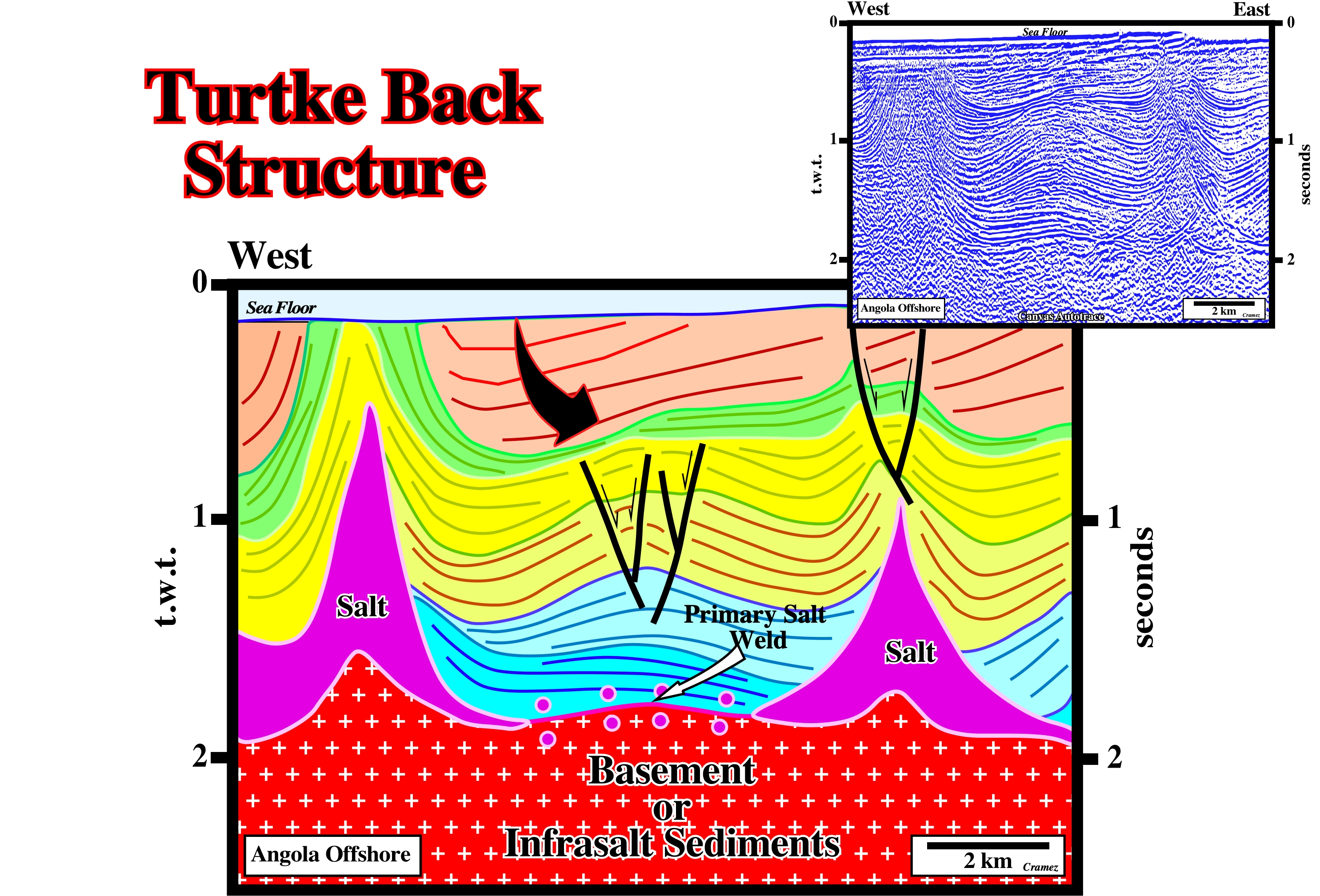
The first sedimentary interval overlying the primary salt weld has an inward thickening. The above interval thick whether the eastward or westward. Theoretically, in a real turtle back structure, there is a tectonic inversion, in which structural high points become low points and vice versa.