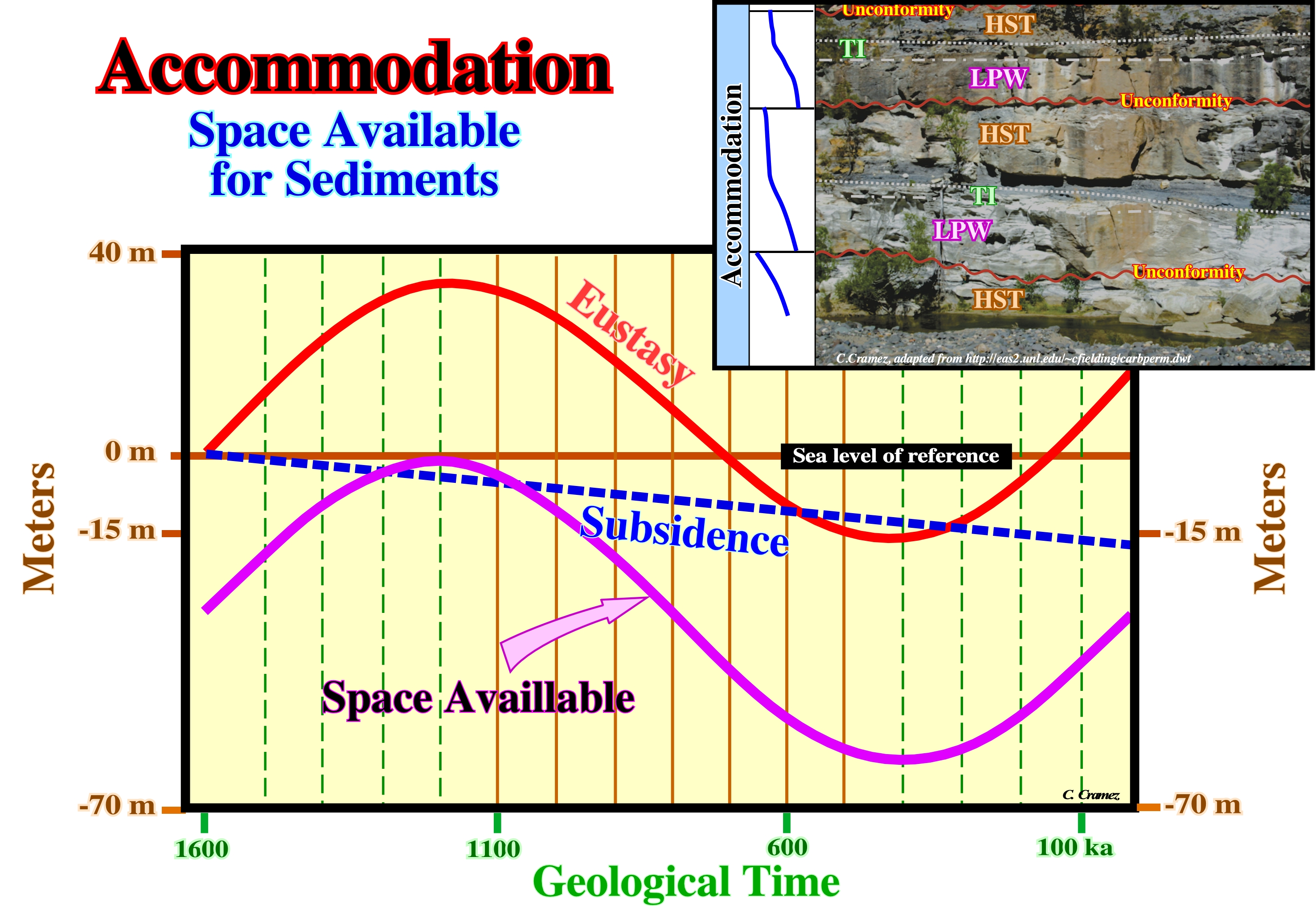

Accommodation (Vail. P. et al., 1989)
Space available for sediments between the sea floor (mainly landward of the shelf break or basin edge, since seaward there is always space available, i.e., accommodation) and the depositional sedimentation level. Synonym of shelfal accommodation. Accommodation is function of eustasy (vertical sea level changes regardless their cause) and subsidence. Changes in accommodation are equivalent to relative sea level changes. Accommodation is required not only for progradational sedimentary packages but retrogradational as well. When accommodation increases, in acceleration, progradational deposits take place. When accommodation increases, in deceleration, retrogradational or backstepping deposits, i.e., regressive deposits take place.
In sand-shale sedimentary intervals, landward of shelf breaks, accommodation is given by the combination of the eustasy and subsidence or uplift of the sea floor. Subsidence is associated with extensional (lengthening) tectonic regimes (σ1 vertical), while uplift is associated with compressional (shortening) tectonic regimes (σ1 horizontal) or with an isostatic rebound as during deglaciations. An accommodation increasing is required for shelfal deposits. Seaward of the shelf break, due to the magnitude of the water depth, deep water sedimentation can take place when accommodation decreases. Often, turbidite depositional systems take place in association with a decreasing of accommodation (relative sea level fall).
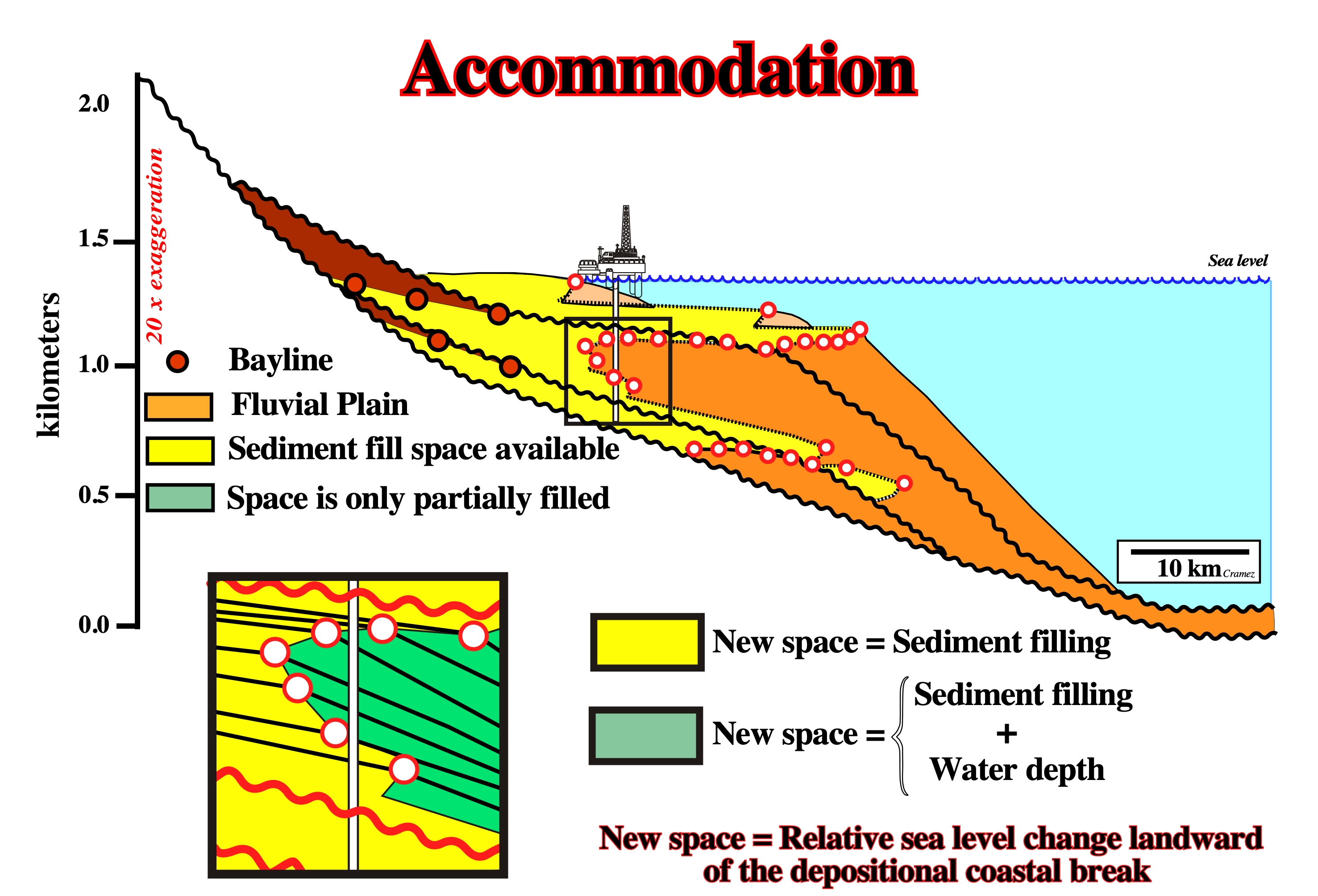
Landward of the shelf break, the accommodation, induced by eustasy when absolute (eustatic) seal level rise, and subsidence, is, almost completely, filled by shelfal sediments (depositional water depth near zero). The shelf break can be coincident or not with the continental edge. In the first case (lowstand geological conditions or during the 2nd stage of development of the highstand prograding wedge) it can, also, corresponds to the shoreline (roughly the depositional coastal break). In the second case, the basin has a shelf (platform) between the shelf break and the shoreline. Seaward of the shelf break only a very small portion of the space available for the sediments is filled by deep water sediments (deposition takes place, mainly, during relative sea level falls). Accommodation corresponds to the water depth minus the sediment filling. In salt basins, particularly, when the thickness of the salt layer is significant, changes in accommodation can be induced by salt flowage (compensatory subsidence).
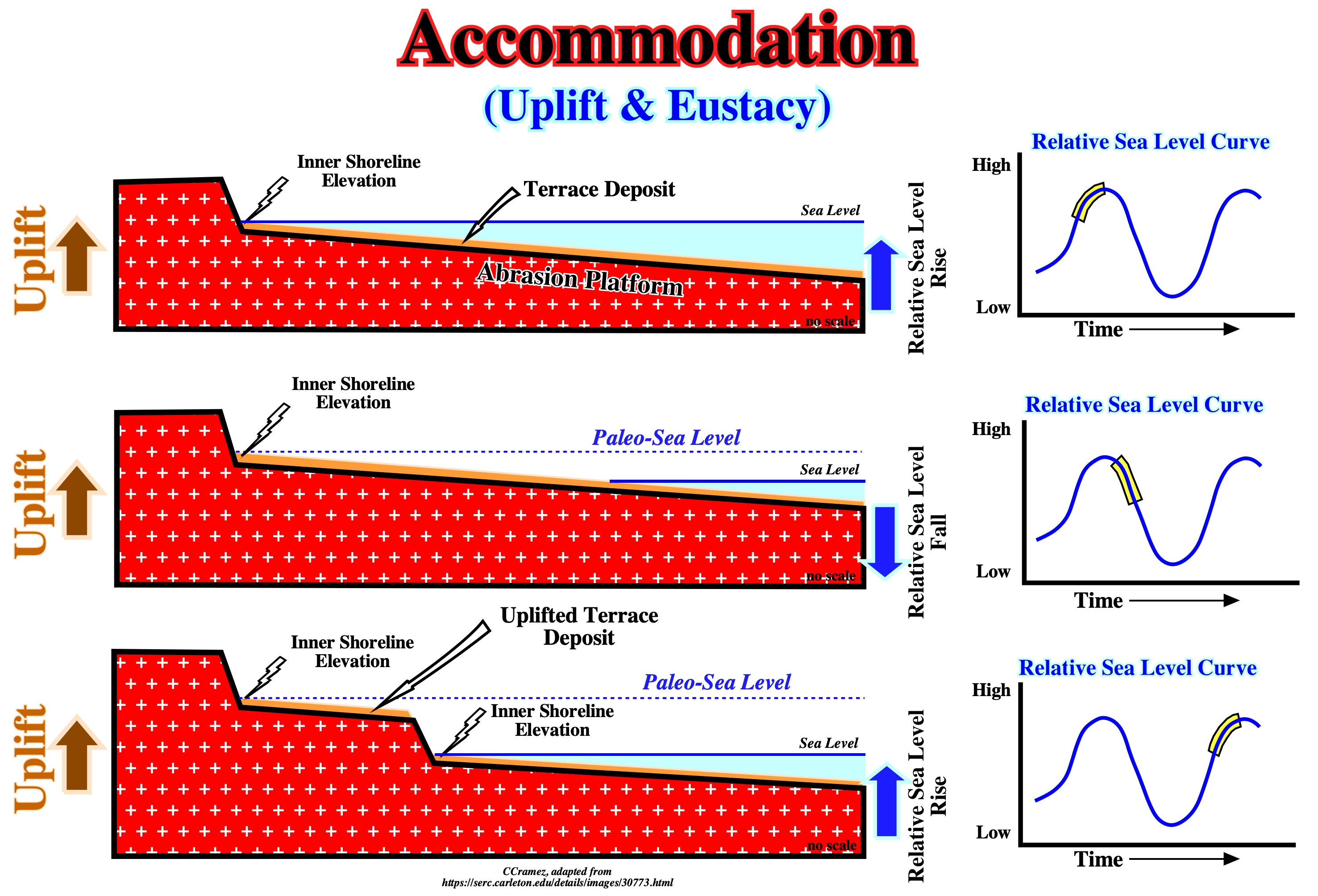
Accommodation can be positive and negative (when there is a relative sea level fall). If there is an uplift of the substratum (sea floor) and a significant absolute sea level rise (eustasy), globally, there is a relative sea level rise (positive accommodation) and terrace deposits can be developed on an abrasion platform. The combined action of tectonics (uplift or subsidence of the sea floor) and absolute sea level induces a relative sea level fall , i.e., a negative accommodation. An abrasion platform can be, partially or totally, exhumed and an uplifted terrace can be created. A new relative sea level rise (positive accommodation) creates, again, a marine ingression (positive accommodation), which displace landward the shoreline creating or increasing the extent of the shelf.
Accretionary Wedge
Secondary sedimentary structure produced by overgrowth, accumulation or addition upon a preexisting nucleus. Accretionary wedges are found in association with B- types subduction zones, as well as, in association with salt flowage in allochthonous structures, such salt sheets, salt laccoliths, salt nappes, etc.
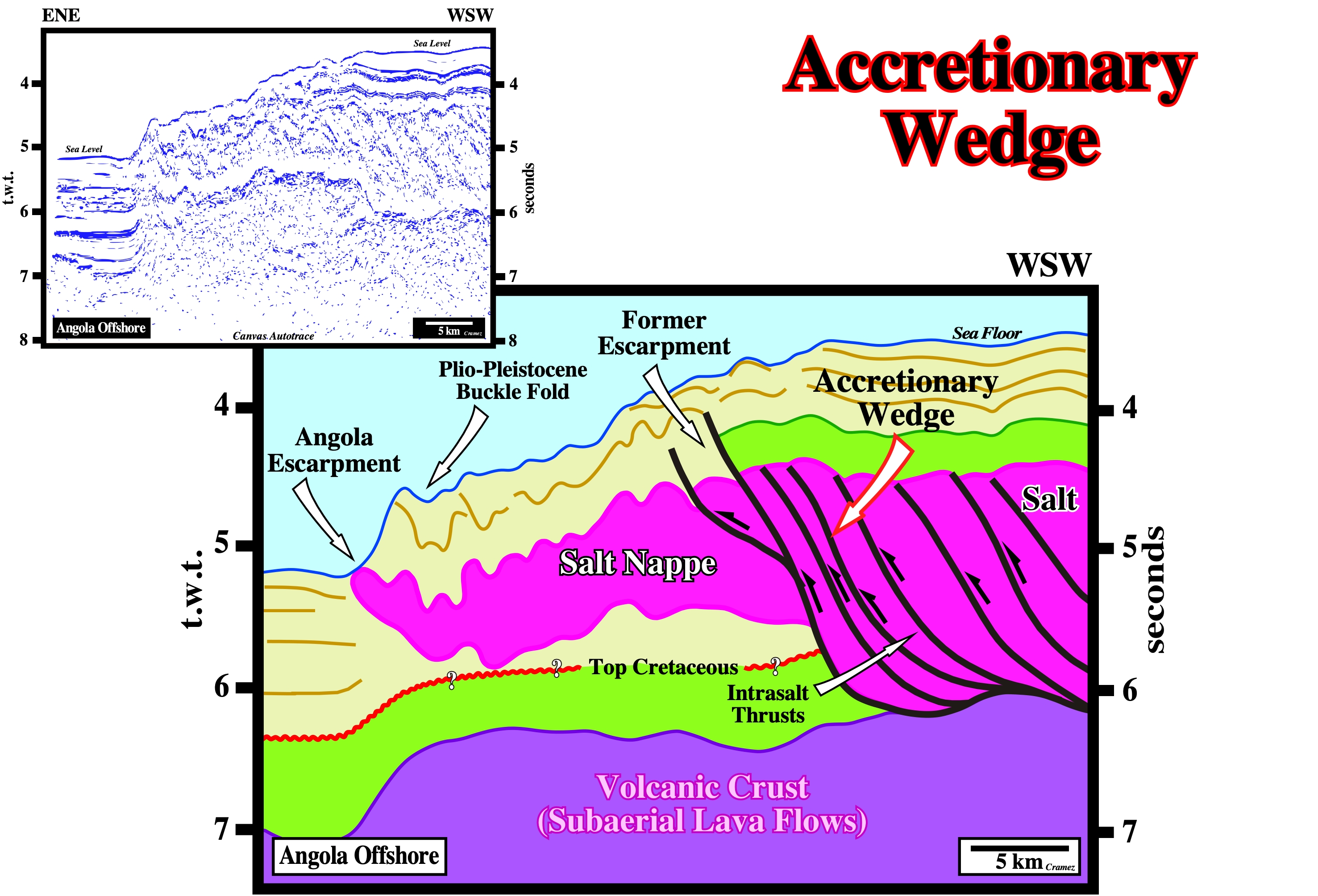
The Angola escarpment, in deep offshore, illustrated above, as well as the Sigsbee escarpment, in Gulf of Mexico, are accretionary wedges of allochthonous salt nappes. The seaward and upward flowage of allochthonous salt are responsible for sea bottom morphology. Seward of Angola escarpment, the sediments are, more or less, undeformed, contrasting, strongly, with the folded geometry of the sediments lying above the salt nappe. The Plio-Pleistocene buckle folds, as well as, the morphology of the sea floor corroborate a, relatively, young compressional tectonic regime (σ1 horizontal) responsible for the shortening of the sediments (salt included). In a depth version of this Canvas autotrace, taking into account the salt thickness in the imbricated zones (eastward of the salt nappe), the bottom of the salt is quite deep. It underlies the western limit of the Angola salt basin. There is another important seismic pitfall on this tentative interpretation. The abrupt change in water depth, induces a pull-down not only of the sea floor, but of the seismic reflectors as well. The velocity of the seismic waves in the water is lower than in the sediments.
Acoustic Impedance
Product of velocity of the seismic waves, in a certain interval, by the bulk density of the interval. Seismic reflections occur along sedimentary interfaces characterized by a break in acoustic impedance.
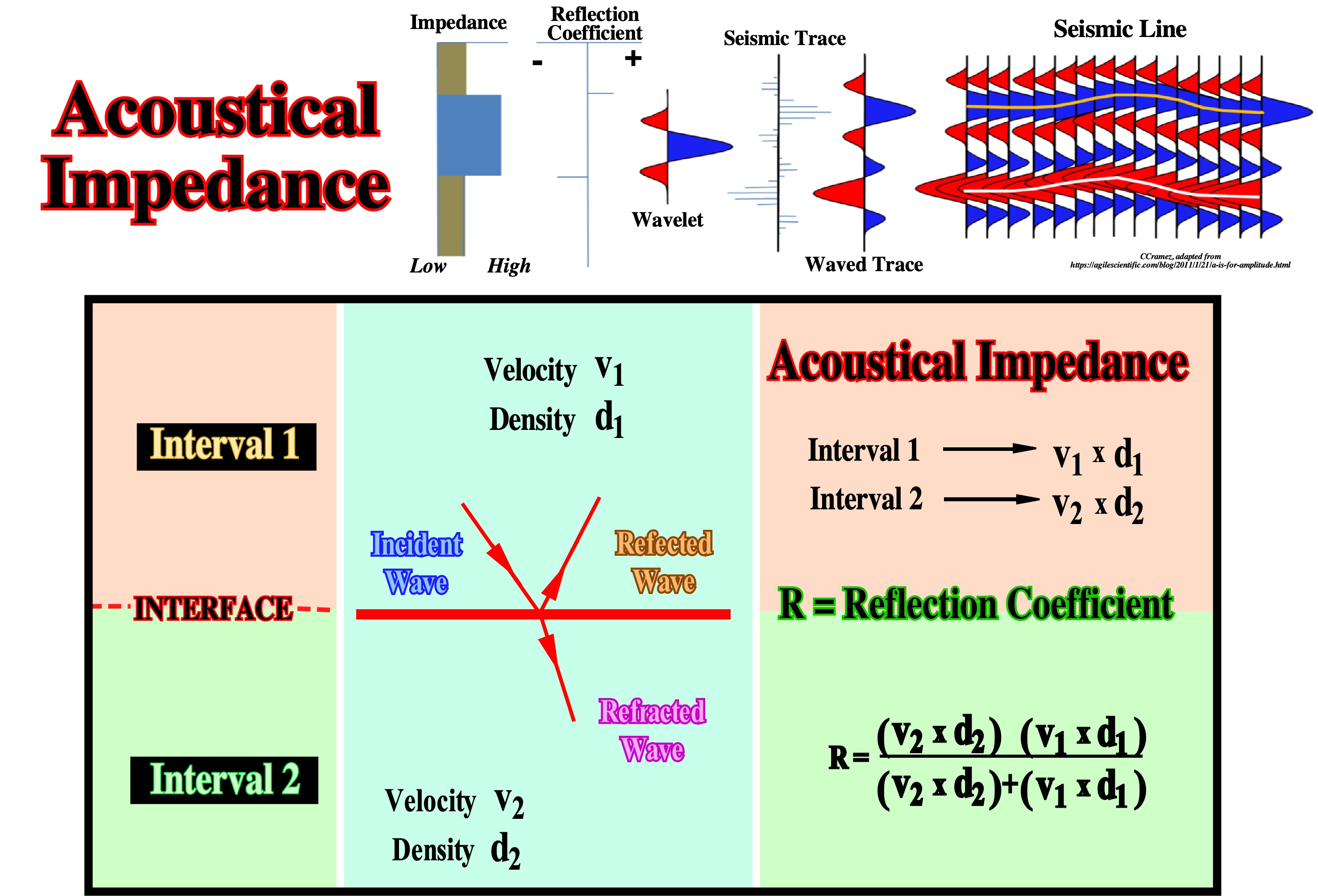
A seismic wave is modified by acoustic impedance breaks through (i) amplitude and (ii) polarity. Theoretically, when between two chronostratigraphic layers, there is no acoustic impedance contrast (V1 x d1 = V2 x d2), it shouldn't have any reflection associated with such an interface, what in not always the case. Most of seismic reflections are associated with chronostratigraphic horizons (set of stratification planes) rather than with lithostratigraphic layers. According to P. Vail such a feature is at the origin of seismic stratigraphy.
Active Piercement (Jackson, M. P. A. and Talbot, C.J.,1991)
A postdepositional diapiric growth (in the most extreme or ideal form) through prekinematic overburden. Synonym of intrusive diapirism. As a diapir increases in relief by growing upward, its base remains at constant depth below the sedimentary surface, and its crest rises toward the sedimentary surface. More commonly, diapirs grow by a combination of ideal end members of active and passive piercement, because sediments accumulate while piercement involves forceful intrusion. This is, probably, the case in, relatively, tall diapirs overlain by relatively thin overburden, unless the overburden is being: (i) lengthened, (ii) fluid or (iii) unusually weak.
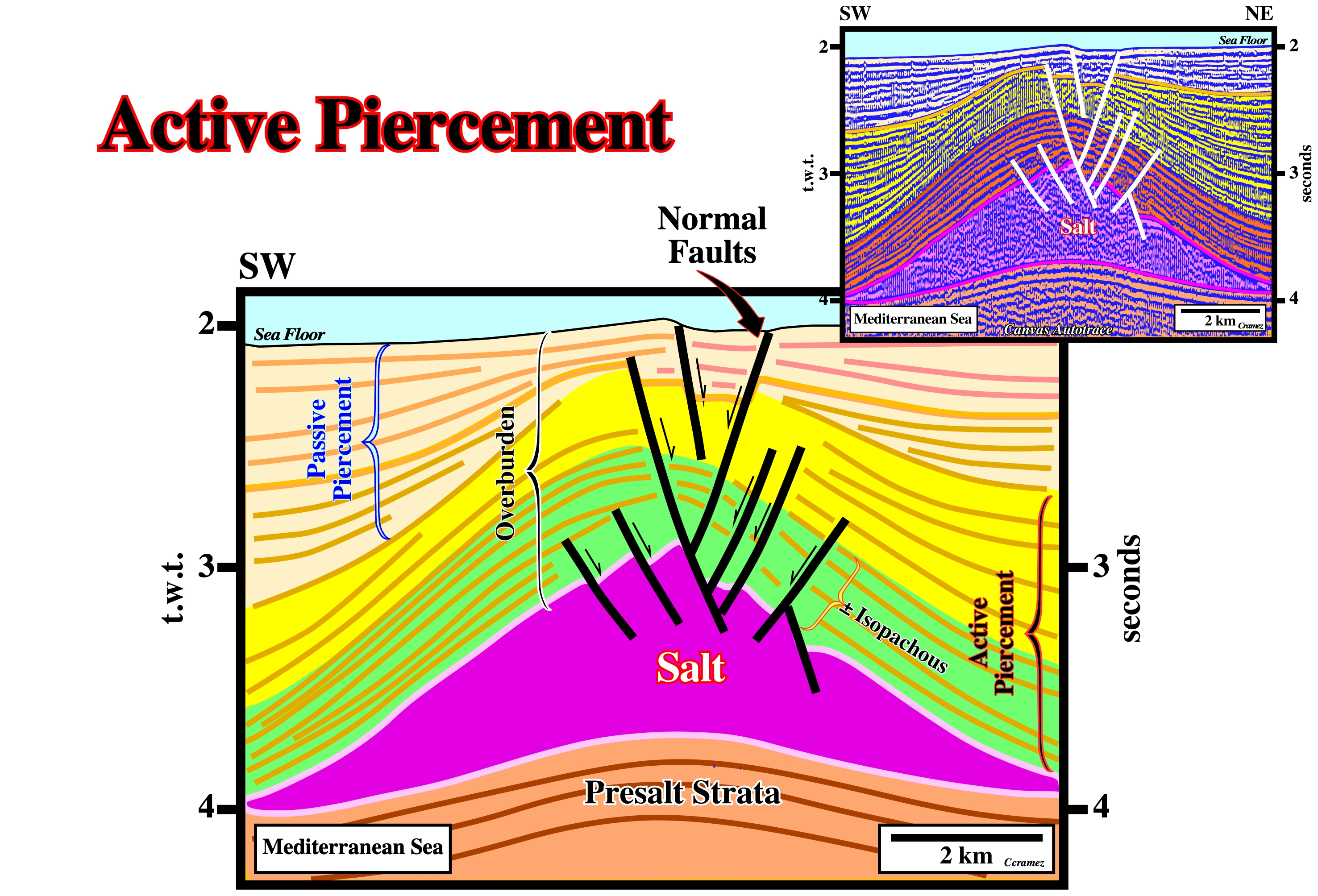
The lower part of the overburden is, roughly, isopachous. The green and yellow intervals can be considered as prekinematic layer, i.e., predating the salt flowage. The upper intervalan (light brown) is synkinematic layers. It has a slightly divergent internal configurations and it onlaps over the yellow interval. The salt structure had an active piercement at the base. The salt movement postdates the deposition of the lower intervals of the overburden. During the upper overburden interval (light brown), the salt movement is contemporaneous of the deposition. On this tentative geological interpretation of a Canvas autotrace of a Mediterranean Sea seismic line, the faults at the top of the salt and in the overburden are normal faults synchronous of the sediment deformation. The overburden sediments were lengthened. The associated bell-shaped structure does not correspond to an anticline (σ1 horizontal), but rather to an antiform (σ1 vertical). The normal faults on the top of the salt antiform, still are active. The relative movement of the faulted blocks affects the sea floor. As the upper part salt layer, is affected by these normal fault, it is quite possible that a brittle brittle interval formed by intercalations of salt and clastic sediments exist above a ductile massif salt.
Active Stage
In active stage a diapir show a postdepositional growth increasing relief by growing upward relatively to the depositional surface. In an active stage, salt domes are intrusive and buckle the sediments of the overburden. Deformation decreases upward. On the contrary, in a passive stage, the upward movement of the salt domes is synchronous of deposition and an apparent diapirism is, often, created.
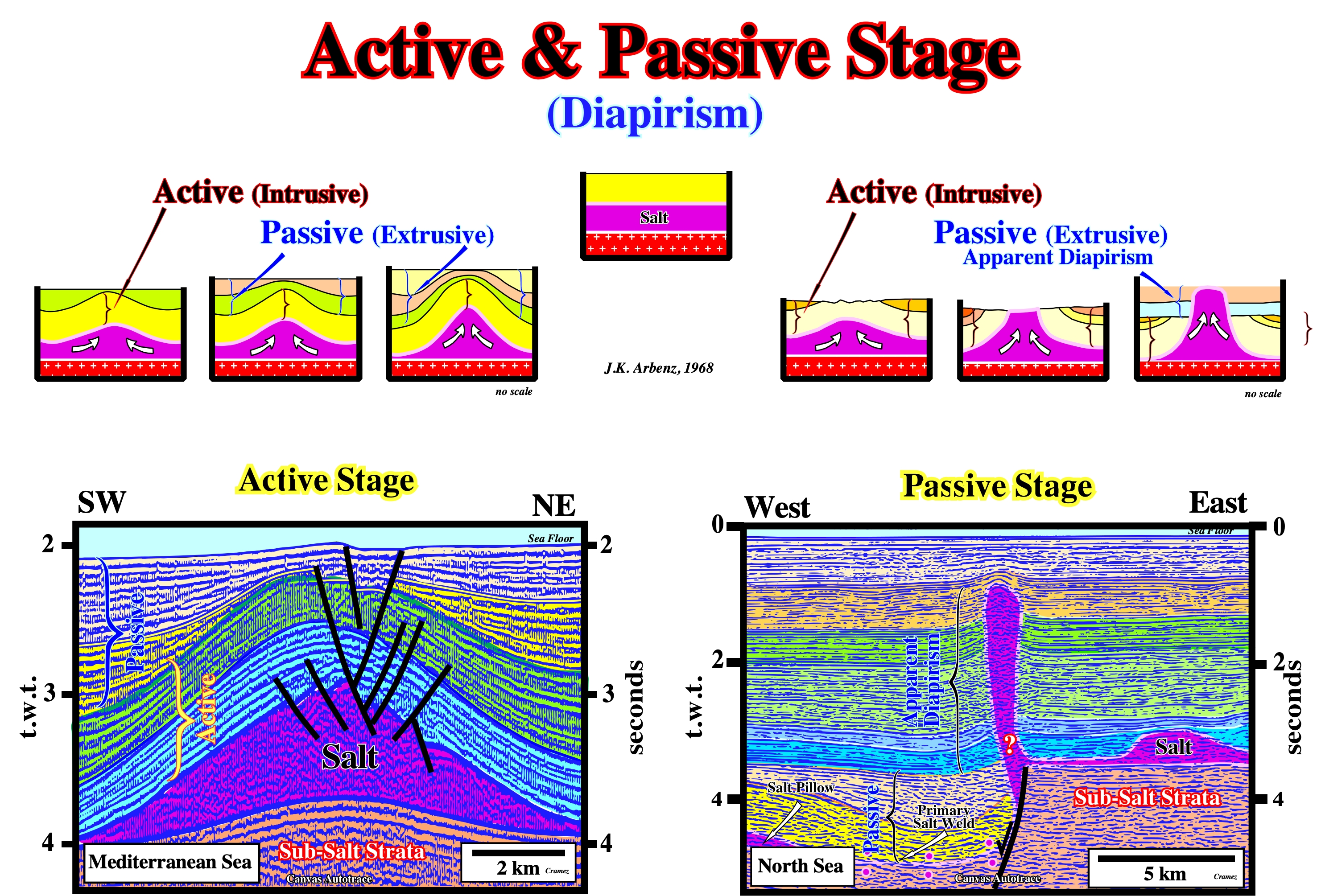
In the active stage, the salt is in its original stratigraphic position (autochthonous salt) and it is intrusive. Its upward movement is posterior to deposition. In the passive stage the salt movement is contemporaneous to deposition and, often, it becomes extrusive. In the active stage, the salt moves upward as the sediments are buried. There is no lateral subsidence changing. The thickness of the adjacent overburden layers is, more or less, constant. The overburden is lengthened by antiform and synform structures. Quite often, the two stages are recognized in the evolution of a diapir. The active stage predating the passive stage. Since the salt of a active salt diapir outcrops a passive stage begins. On these tentative interpretations of Canvas autotraces, it must be notice that in the active stage example (Mediterranean Sea), the normal faults on the top of the salt antiform, still are active, since their movement affects the sea floor. As the upper part of the salt layer, is also affected by normal faulting, two salt levels are possible (i) An upper brittle interval formed by intercalations of salt and clastic sediments and (ii) A lower ductile massif salt level. In the passive stage example (North Sea), the mother salt layer or the salt induced tectonic disharmony seems to be displaced and buried westward of the growth-fault from which the salt diapirs rises. A primary salt weld and salt pillow are visible in the hangingwall.
Aggradation
Vertical component of coastal onlapping, i.e., the upbuilding between two consecutive onlaps. In salt tectonics, salt aggradation can be be observed on the deposition of autochthonous salt, as in Angola or Brazil offshore. In the development of a allochthonous salt tongue, salt aggradation can be measured by basal cutoffs.
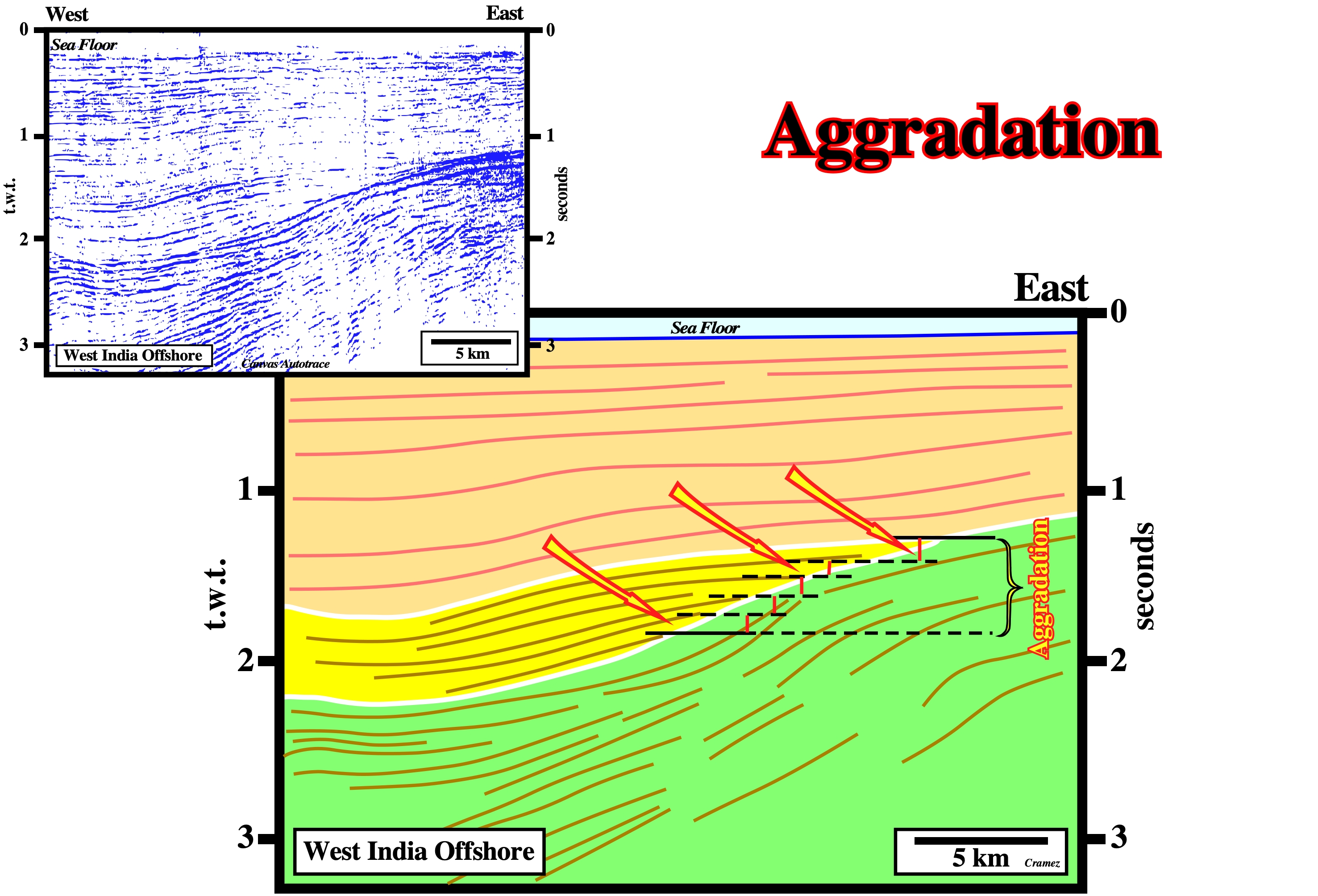
The vertical component between two consecutive onlaps gives the sedimentary aggradation, which, landward of the depositional coastal break, emphasizes to the associated relative sea level rise, since depositional water depth is near zero. Aggradation, generally, is positive. A positive aggradation (marine ingression) is, always, recognized in retrogradational and regressive sedimentary intervals. In a sedimentary transgressive interval (regressive intervals increasingly smaller), aggradation increases, progressively, while in a regressive interval, it decreases, progressively. A negative aggradation emphasizes a relative sea level fall, which induces an unconformity (erosional surface), when the relative sea level falls below the basin edge creating lowstand geological conditions. On this geological tentative interpretation of a Canvas autotrace of a West India offshore seismic line, the vertical difference between two consecutive onlaps gives the aggradation in time, which can later be converted into depth. The horizontal difference between two consecutive onlaps gives the coastal encroachment, when the onlaps are coastal onlaps or marine encroachment when the onlaps are marine onlaps. In this particular example, as the onlaps are marine, we can speak in marine aggradation and marine encroachment.
Aggradation Rate (Salt Laccolith Injection)
During a sheet laccoliths injection, the aggradation rate of the allochthonous salt can be, easily, determined by basal cutoffs, which suggest, often, aggradation rates hundred times smaller than injection rate.
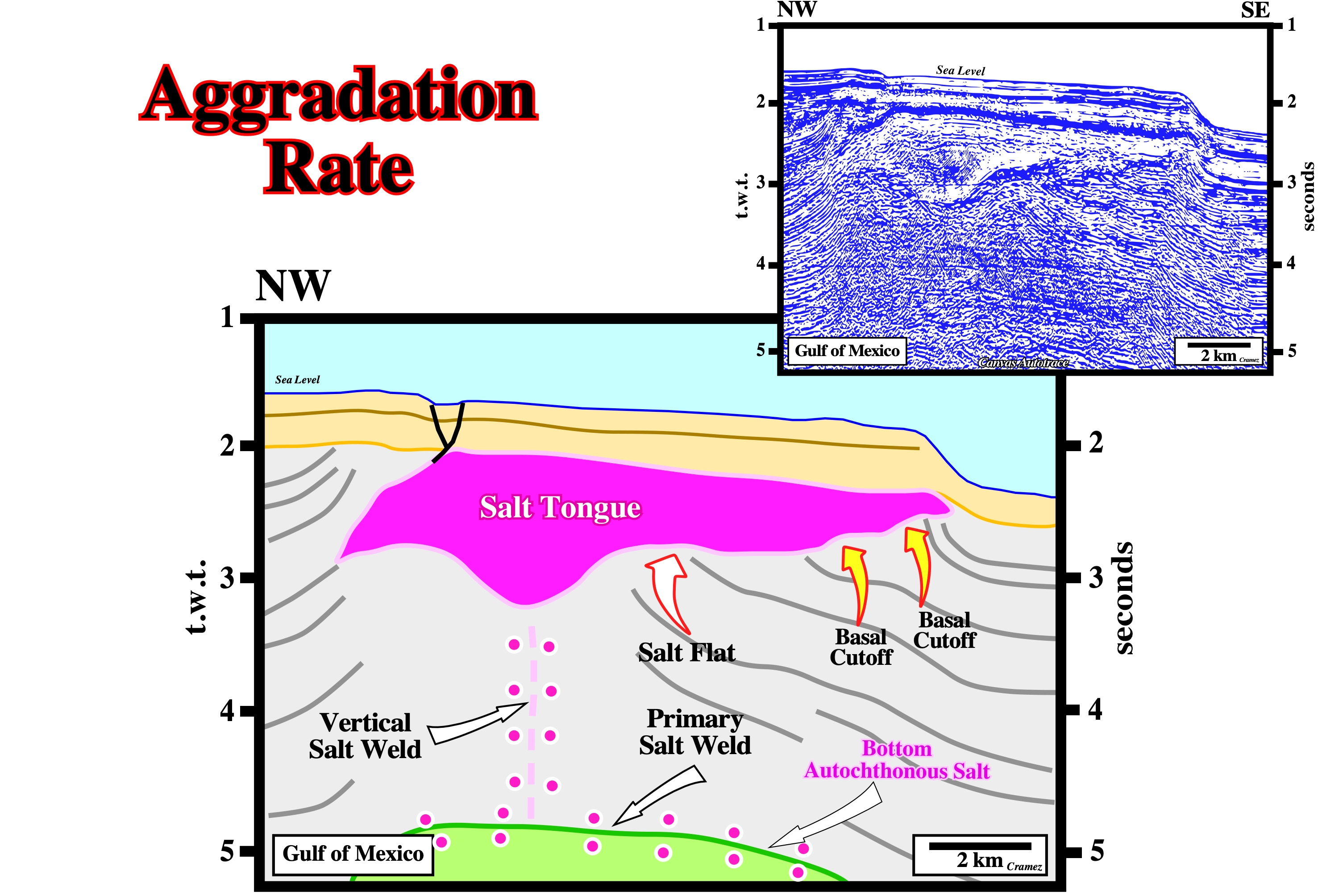
On this tentative interpretation of a Canvas autotrace of a Gulf of Mexico seismic line, the aggradation rate given by the basal cutoffs, is much smaller than the injection rate given by the salt flats. The basal cutoffs correspond to an upbuilding, while the salt flats can be considered as an outbuilding feature. On this example, the original diapir stem became a vertical salt weld or secondary salt weld. The stem closed, progressively, as adjacent strata moved inward, probably, along a deeper primary salt weld. The morphology of the sea floor is, strongly, affected by the emplacement of the salt tongue.
Albite (R. L. Bates and J. A. Jackson, 1980) (McNeill L. et al., 1999)
A colorless or milky-white triclinic mineral of the feldspar group: Na(AlSi3O8). It is a variety of plagioclase with composition ranging from Ab100AN0 to Ab90AN10. Albite is, also, an alkali feldspar, representing the triclinic modification of sodium feldspar. Albite occurs in all group of rocks, forming a common constituent of granite and of various acid-to-intermediate igneous rocks.
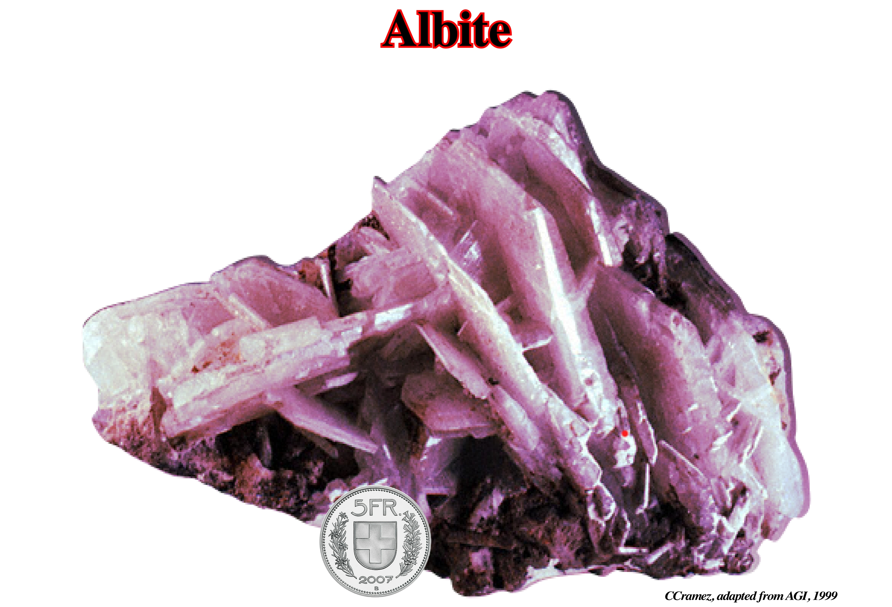
Albite is widely distributed in low-temperature metamorphic rocks (greenschists facies) and is, regularly, deposited from hydrothermal solutions in cavities and veins. Albite crystals frequently exhibit polysynthetic twinning, predominantly, after the albite law (rule specifying the orientation of alternating lamellae in multiple twin feldspar crystals). There are many varieties of albite: (i) Andesine ; (ii) Cleavelandite ; (iii) Analbite ; (iv) Oligoclase ; (v) Pericline ; (vi) Peristerite, etc. Albite becomes anorthose as soon as its potassium content is higher than 10%, replacing sodium. On the other hand, it becomes oligoclase as soon as its calcium content is higher than 10%, always replacing sodium. It can, sometimes, show an effect of adularescence (optical phenomenon, similar to labradorescence and aventuresecence that is produced in gemstones such as moonstones) or peristerescence (broad, diffuse white or bluish schiller or interference effect, seen in certain directions in some translucent sodic plagioclase as it is turned around). Transparent faceted quality is rare. The most coveted ornamental variety cut into cabochon (shaped and polished as opposed to faceted, forming an usually a convex obverse with a flat reverse) or small decorative items is the green Maw-sit-sit from Myanmar (https://www.gemmo.eu/fr/albite.php).
Albitization (R. L. Bates and J. A. Jackson, 1980)
Introduction of, or replacement by, albite, replacing, usually a more calcic plagioclase.
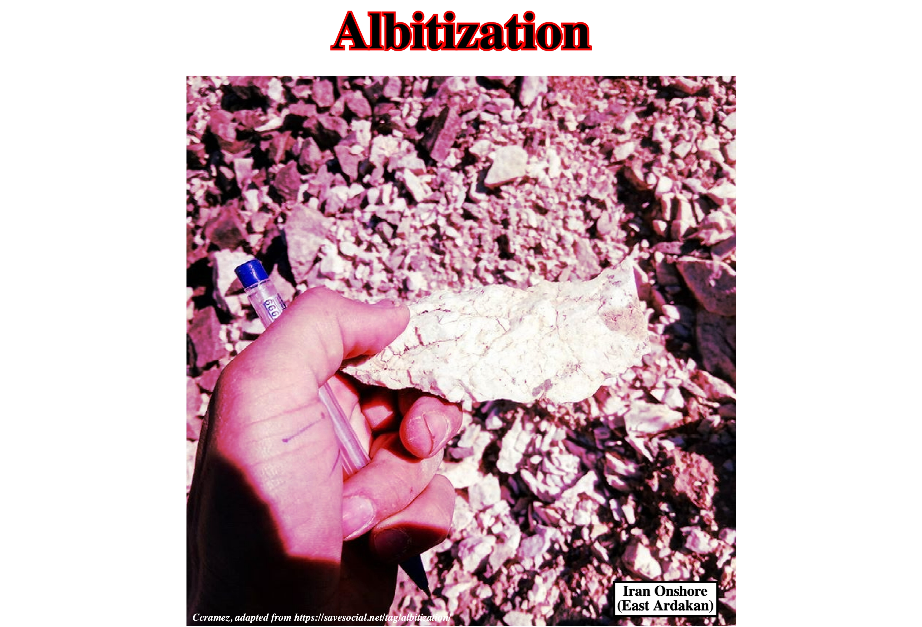
Albitization is a common process during which hydrothermal fluids convert plagioclase and/or K-feldspar into nearly pure albite. However, its specific mechanism in granitoids is not well understood (https://academic.oup.com/petrology/article/53/5/919/1528580). Albitization in granitoids causes an overall change in bulk composition dominated by the production of Na-rich minerals in the rock with a concomitant removal of K by the fluid. The Na-rich fluid can induce albitization by transforming any Ab–Or–An solid solution into nearly pure albite. Albitization was studied at least as far back as the early 20th century and affects enormous tracts of the Earth's crust ranging from sedimentary basins to magmatic systems. During albitization the original textures of the granitoid rocks may remain well preserved, even after complete alteration of the primary mineralogy. The metasomatic process, i.e., the chemical alteration by hydrothermal and other fluids, may also cause severe leaching of rare earth elements (REE) and other trace elements from the albitized granitoids.
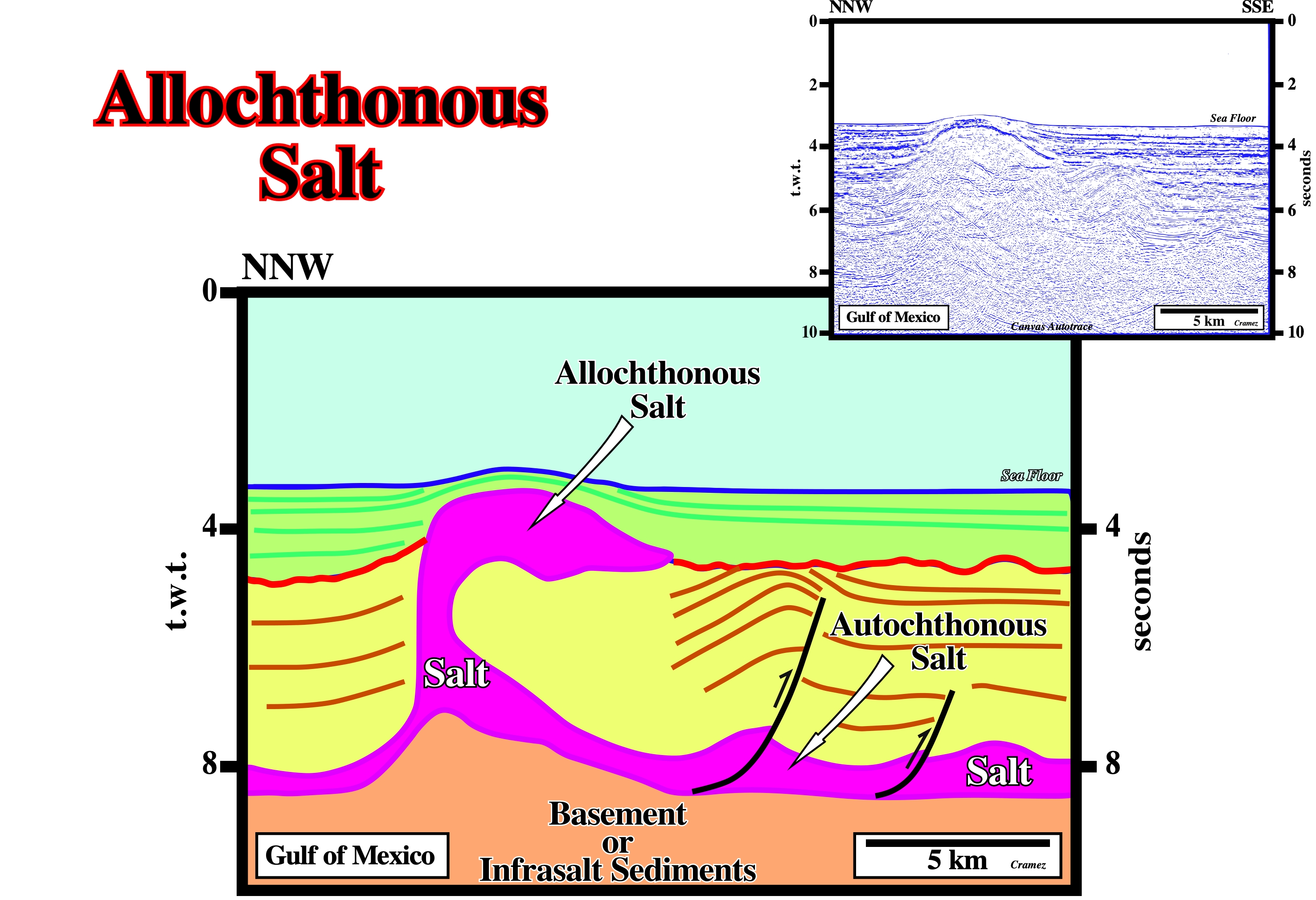
Allochthonous Salt
Salt layer overlying part of its overburden. A sheet like salt body tectonically emplaced at stratigraphic levels overlying the autochthonous salt layer. It lies within stratigraphically younger strata.
On this tentative geological interpretation of a Canvas autotrace of Gulf of Mexico deepwater seismic line, it is, easy, to recognize the difference between allochthonous and autochthonous salt. Autochthonous salt is in its original stratigraphic position, while allochthonous salt is not. In this particular example, both salt layers communicate by a, more or less, vertical stem. The sea floor is affected by the emplacement of the allochthonous salt. A tectonically enhanced unconformity (eastward of the allochthonous salt) called, often, angular unconformity, developed in association with a local compressional tectonic regime (σ1 horizontal). This local tectonic regime was, probably, created as a counterpart of an updip the salt extension , as it is the case, for instance, in the Angola an Gabon deepwater offshore. Westward of the allochthonous salt structure, the tectonically enhanced unconformity correlates with a cryptic unconformity. Certain geoscientists call it eustatic unconformity, just to emphasize the fact that eustasy is the main parameter in the development of the relative sea level fall responsible of the unconformity (erosional surface).
Allochthonous Salt Structures
Salt structures in which the salt is not in its original stratigraphic position. Allochtonous sal structures can be attached or not to the autochthonous salt layer. A terminology for the allochthonous salt structures was proposed by the Sub-commission on Tectonic Nomenclature (International Union of Geological Sciences). The more common allochthonous salt structures are illustrated in figure below.
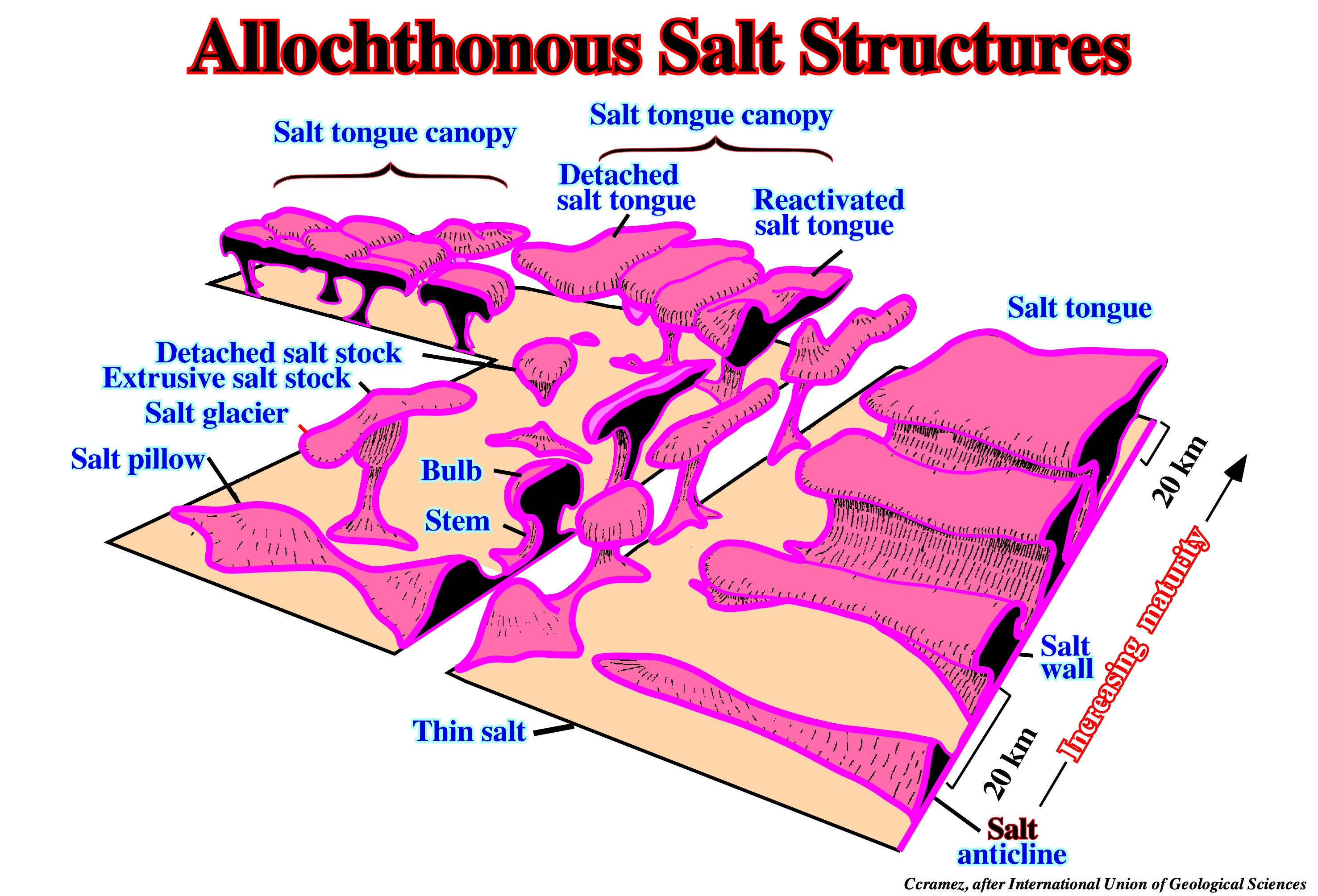
This block diagram shows the majority of the allochthonous salt structures, i.e., structures in which the salt is not in its original stratigraphic position: (i) Salt tongue canopy ; (ii) Detached salt tongue ; (iii) Reactivated salt tongue ; (iv) Bulb ; (v) Salt glacier ; (vi) Extrusive salt stock ; (vii) Detached salt stock, etc. As illustrated on this geological sketch, the structural maturity and size of these salt structures increases toward the composite, coalesced structures in the background. Several geoscientists reserve the term allochthonous salt just when the salt sheet remains attached to its source layer. M. Jackson (1991) evoked two main reasons for this liberal definition: (i) Allochthonous salt is transported from its original position and rests on a different substratum regardless of whether its roots remain attached ; (ii) Determining whether a salt sheet is detached or connected by only a thin stem is, generally, impracticable, even with modern seismic data. Therefore, the terminology of allochthonous salt structures cannot be definitive. Several overlapping terms are currently in use. The terminology proposed by the Sub-commission on Tectonic Nomenclature (International Union of Geological Sciences) is followed in this glossary.
Ampferer Subduction Zone
Collision zone in which the continental crust of a lithospheric plate sinks under the continental crust of another tectonic plate. Synonym of A-type subduction zone. Ampferer, an Austrian geologist, when balancing Alpine geologic cross-sections, noticing a significant lacking of substratum, he assumed the substratum sunk till great depths under the fold belt. The geological mechanism in an Ampferer subduction zone is, completely, different of the one in a Benioff subduction zone (B-type subduction zone).
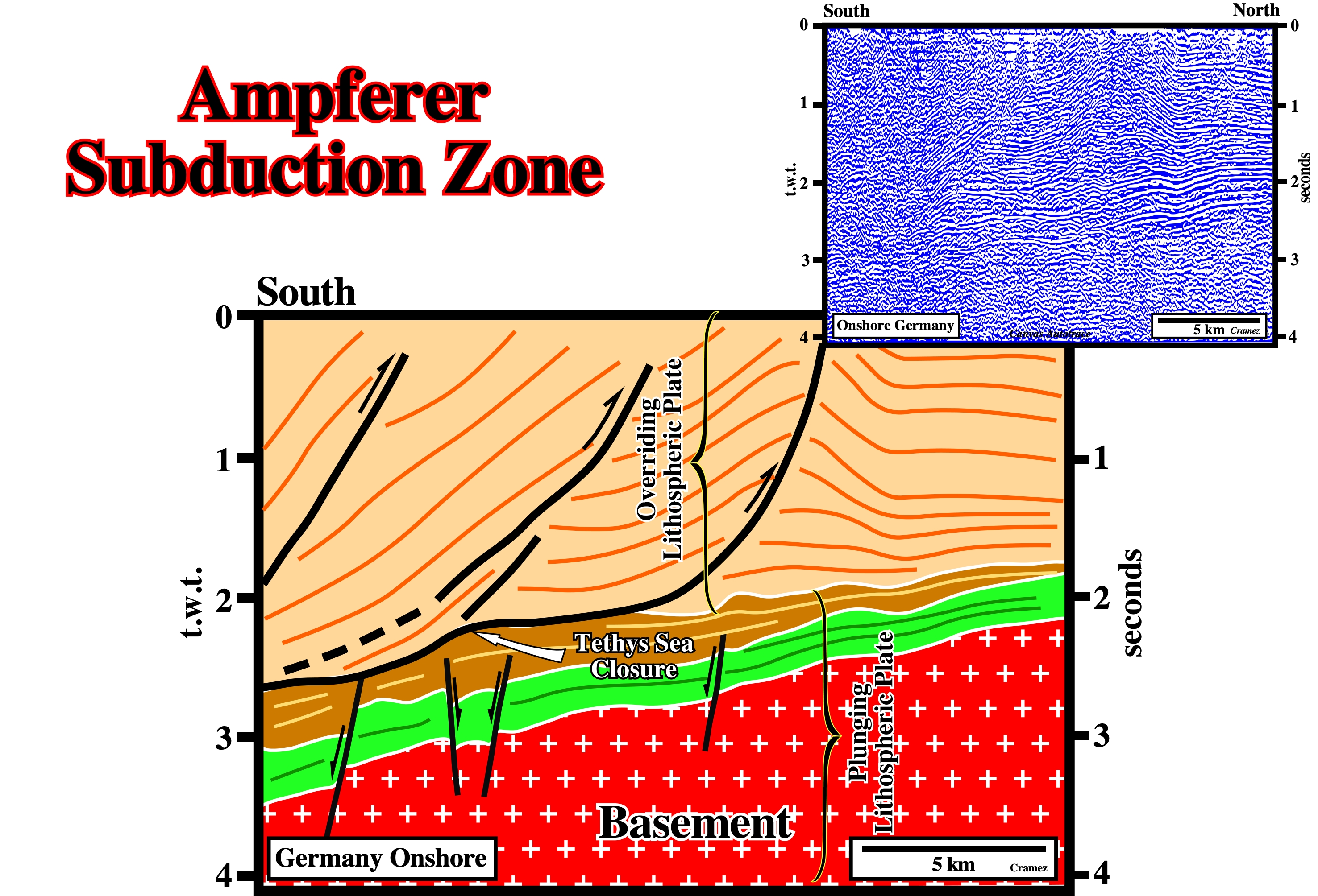
On this tentative interpretation of a Canvas autotrace of a Germany onshore seismic line, Mesozoic sediments sunk under Tertiary sediments creating an Ampferer subduction zone, responsible for a geological collision and an ocean closure. The surface between the two lithospheric plates (interface defined by the brown and beige seismic intervals), which underlying the tectonic disharmony, marks the closure of the Tethys Sea. Initially, i.e., before the "collision" (kinetic energy does not play any role in plate tectonics), the sedimentary packages, separated by the tectonic disharmony, belonged to different lithospheric plates.
Anticline (Salt)
See Salt Anticline
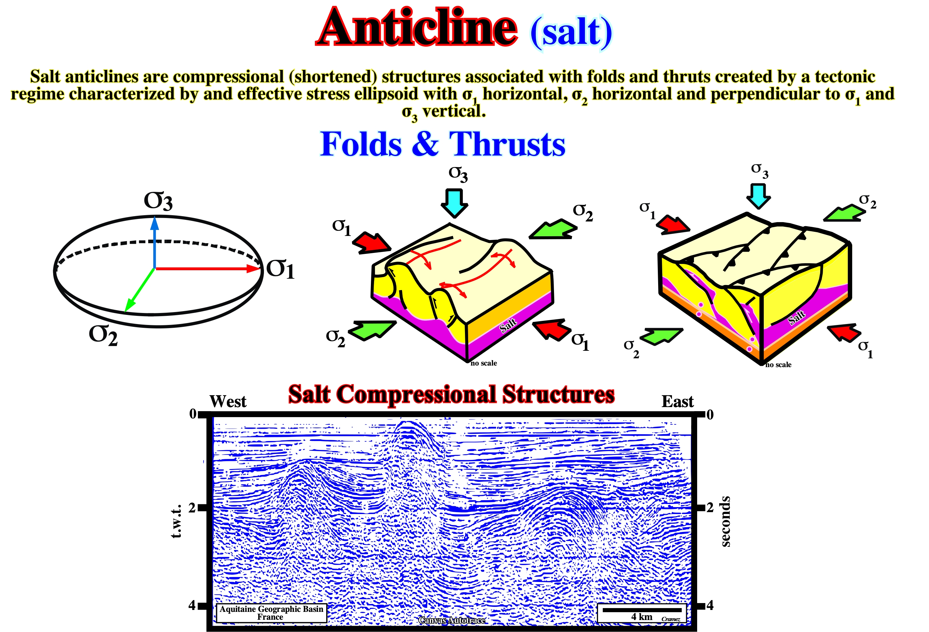
When a stratigraphic column, with or without a salt layer interbedded, is submitted to a compressional (shortening) tectonic regime, characterized by an ellipsoid of the effective stresses with a σ1 (maximum effective stress) vertical and a σ3 (minimum effective stress) vertical, all sedimentary column is shortened by folding and reverse faulting, creating anticlines and/or thrust faults. When an anticline structure has a significant salt layer interbedded, some geoscientists call it salt anticline, just to precise that the salt structure was created by shortening and not by halokinesis, which can develop antiforms, i.e., lengthened structures induced by normal faulting. On this Canvas autotrace of a France onshore seismic line (unmigrated line), the shortening of the sediments, below the tectonically enhanced unconformity, is quite well visible. On the contrary any shortening is evident in association with the passive diapir in the central area of the autotrace, above the tectonically enhanced unconformity.
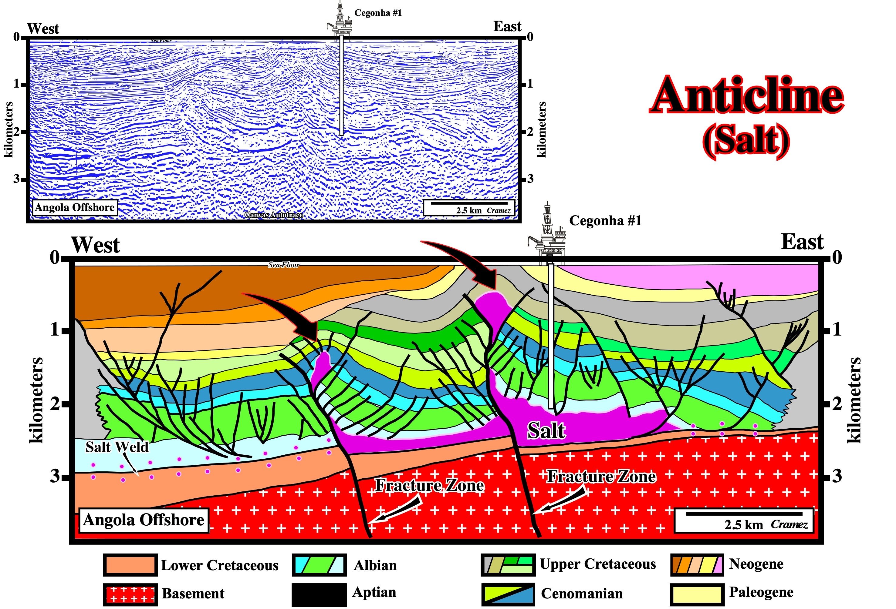
On this tentative interpretation of a Canvas autotrace of an Angola offshore seismic line, two salt anticlines (shortening structures) are, easily, recognized in association with two fracture zones, affecting, clearly, the bottom of the salt as well as the basement rocks. The majority of the geoscientists working in this area think the sedimentary shortening is related with the movement of the faulted blocks of this complex the fracture zone, which delimits different geological and petroleum provinces. The faults associated with these fracture zones are reverse faults with a significant horizontal component. They contrast with the normal faults induced by salt flowage, which die along salt welds. The location and drilling of Cegonha #1 predated the reprocessing and depth conversion of the original seismic line. At the time of the drilling (80's), geoscientists using unmigrated seismic lines interpreted salt domes in a erroneous way, i.e., with a phallic morphology. Actually, the Cegonha well was supposed to test the eastern flank of a salt dome with almost vertical walls. After reprocessing and depth migration of the few seismic lines, as well as, a significant increasing knowledge in salt tectonics, the phallic morphology of the salt diapirs disappeared from the tentative geological interpretations, as illustrated above.
Antiform (Salt)
Elongated upwelling of salt with concordant overburden. Salt antiforms are, often, erroneously, taken as synonym of salt anticlines. Anticline is a genetic term to describe a compressional structure. Antiform is a non-genetic term to describe a bell-shaped geometry. All anticlines are antiforms, but not all antiforms are anticlines.
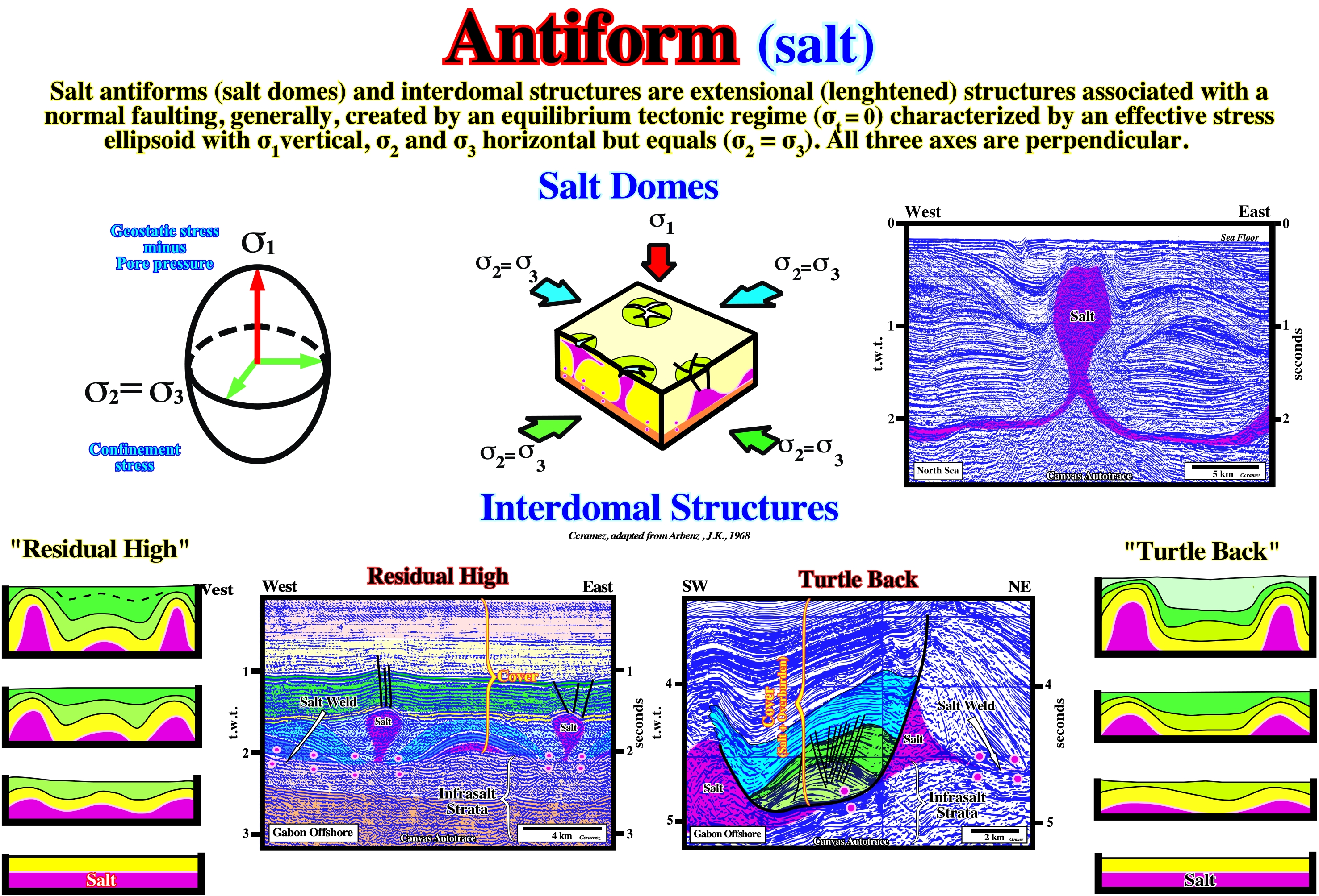
Salt antiforms and salt residual highs are extensional structures created just by halokinesis, which is the name given to an equilibrium tectonic regime with σt = 0 (tectonic vector null), induce by the salt properties and characterized by a biaxial ellipsoid of tectonic stresses (σ1 vertical, σ2 = σ3 and perpendicular). With such a tectonic regime, locally, the salt, whose density is constant in depth (salt is not compactable) moves upward lengthening the overburden by normal faulting. Two main types of structures can develop : (i) Salt domes and (ii) Interdomal structures. In the interdomal structures two types of overburden antiform structures can developed: (i) Antiforms with salt residual high in the core of the structure, known, often, just as salt residual highs and (ii) Antiforms without salt residual highs, known as "Turtle Back" structure. In this figure are illustrated Canvas autotraces of seismic example of these structures, and a possible evolution of the Interdomal structures proposed by J. K. Arbenz (1968).
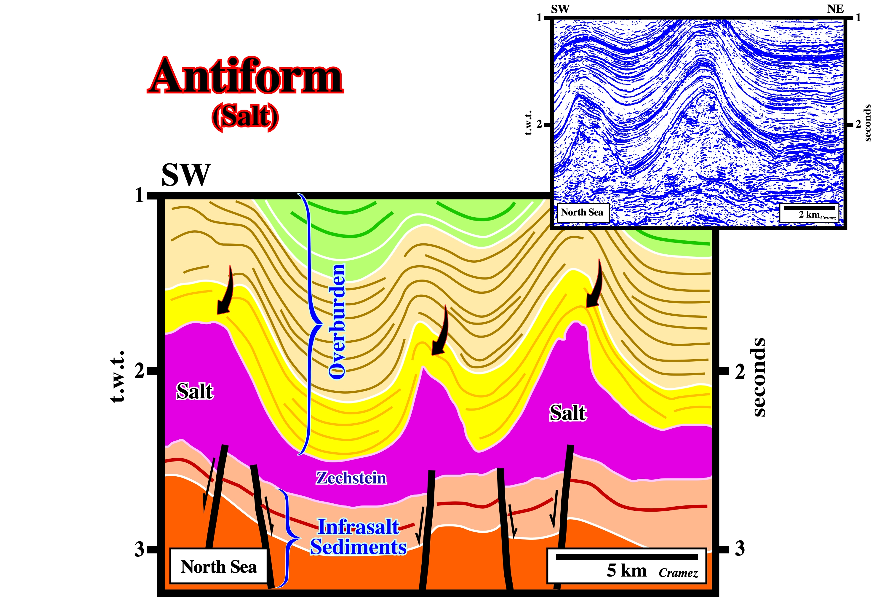
On this tentative geological interpretation of a Canvas autotrace of a North Sea seismic line, the salt structures, with a bell-shape geometry, are extensional. They were developed under an extensional tectonic regime characterized by a vertical maximum effective stress (σ1 vertical). Under such a regime, which took place long-time after the salt deposition, the salt flowed upward forcing the overburden to lengthen. Later, the cover (salt + overburden) was slightly shortened by a compressional tectonic regime (σ1 horizontal). The salt induced tectonic disharmony is at the bottom of the salt. Above the tectonic disharmony, the cover (salt+ overburden) is quite deformed (lengthened), while the subsalt strata are not (take into account the pitfall induced by the lateral variation of salt thickness).
Anhydrite (McNeill L. et all, 1999)
A mineral consisting of anhydrous calcium sulfate: CaSO4. It represents gypsum without its water of crystallization and it alters, readily, to gypsum, from which it differs in crystal form (anhydrite is orthorhombic) and in being harder and slight less soluble.
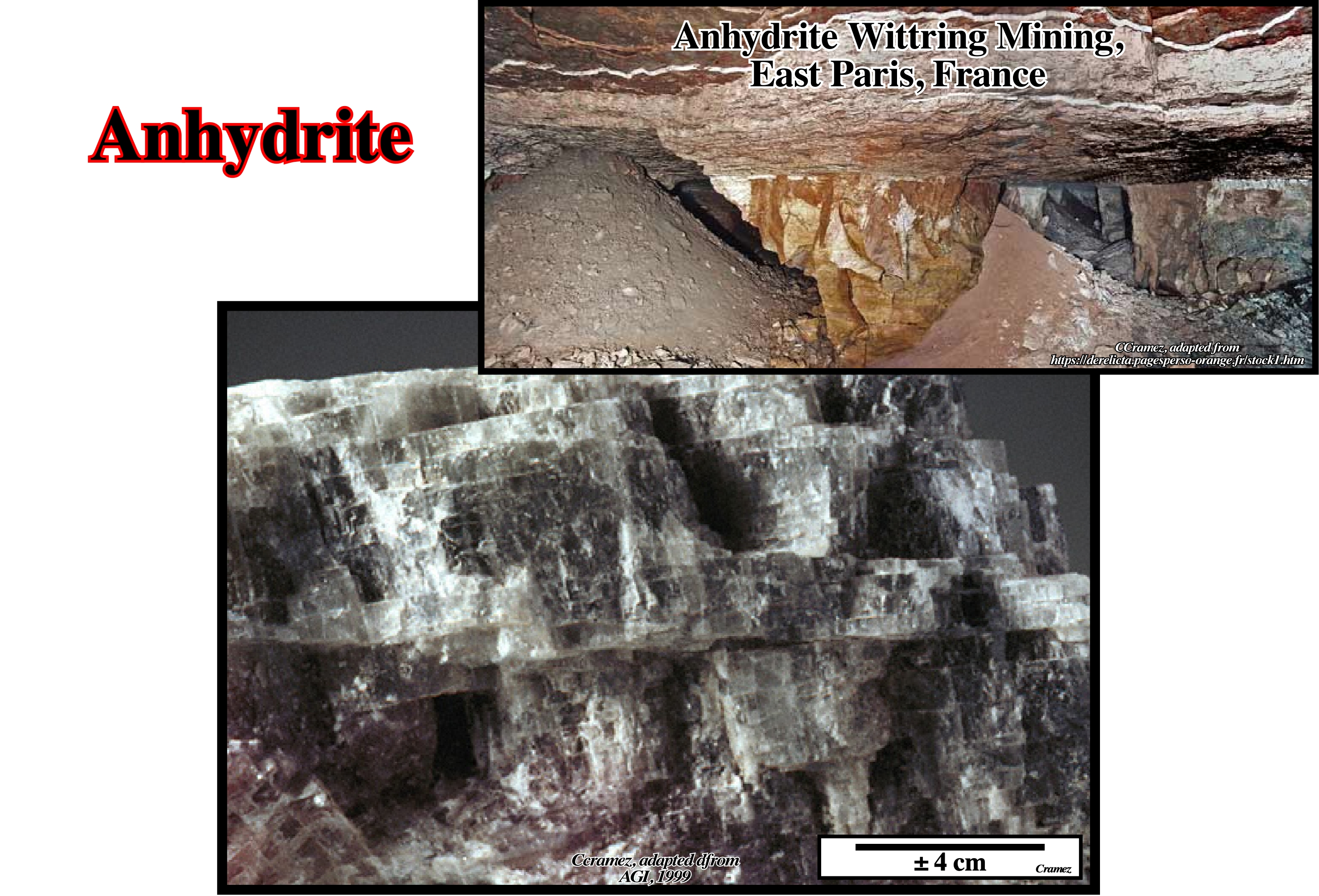
Anhydrite occurs, usually, in white or slightly colored, granular to compact masses, forming large beds or seams (a distinct layer of vein of rock in other layers of rock) in sedimentary rocks or associated with gypsum and halite in evaporites. Anhydrite also denotes a rock, i.e., a massive evaporite, very rarely observed in surface outcrop, essentially, based on this orthorhombic mesh mineral, quite heavy with a density close to 3, higher than that of calcite, and moderately hard (harder than gypsum). Anhydrite can includes traces of strontium (Sr), barium (Ba) and water (H2O), even rare traces of gypsum. Anhydrite can be used to make sulfuric acid, as a soil modifier or fertilizer, as desiccant in plasters, in the fabrications of cements, paints, varnishes, etc.
Apparent Diapirism (Arbenz, J. K., 1968)
Apparent upward movement. When an active diapir arrives on surface, if it is connected with the mother layer, it growths as sedimentation progresses by an apparent diapirism as an passive diapir. Geometrically, apparent diapirism does not deform the coeval sediments (synkinematic). Prekinematic sediments show significant deformation.
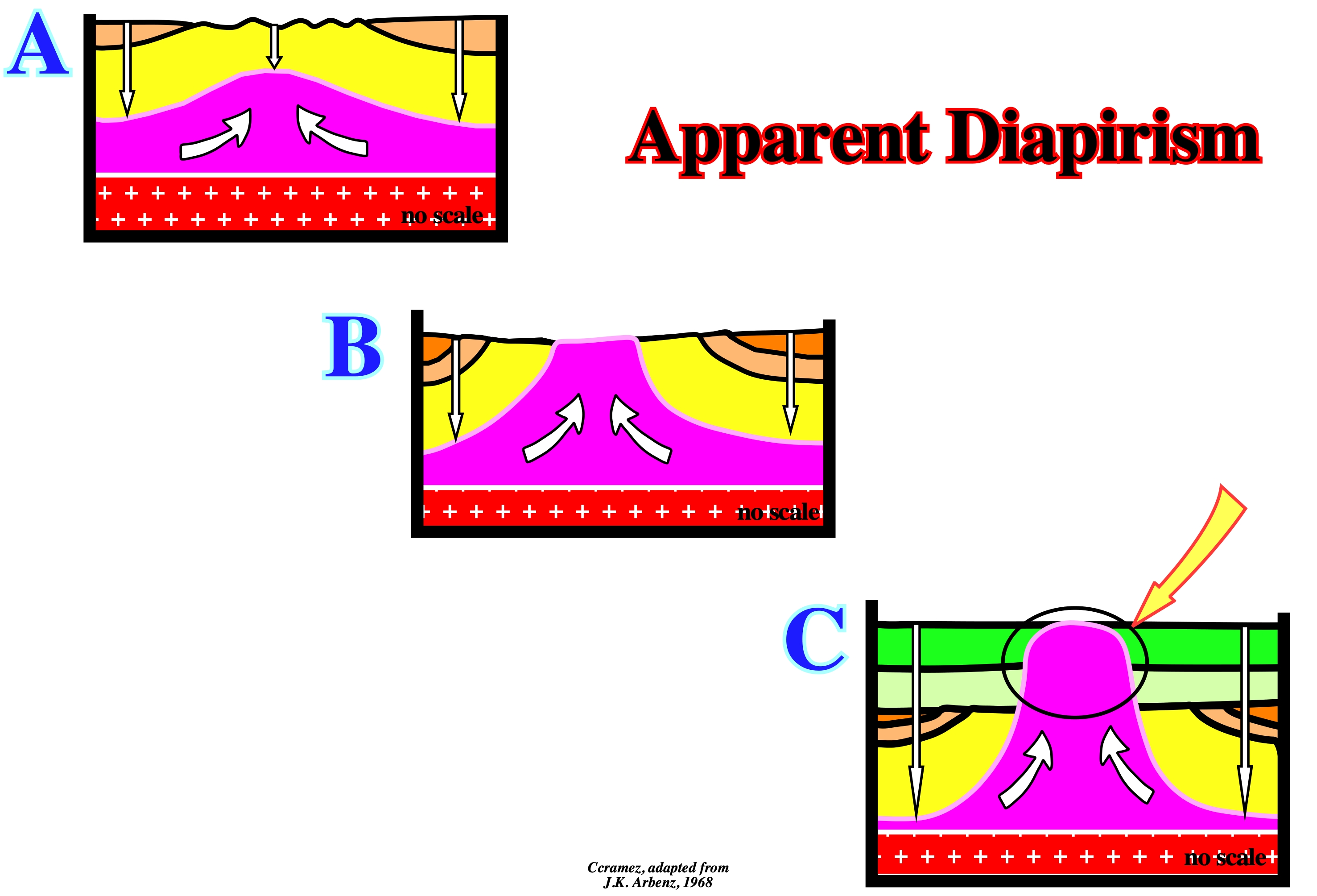
When a salt diapir, connected with the mother source rock, arrives on surface, which is the case in this geological model, the salt growths upward as sedimentation takes place giving a false impression of diapirism, that Arbenz called apparent diapirism. The erosional surface (unconformity) associated with salt diapirism is formed during of the active piercement when deformed overburden layers arrive in surface, i.e., when they outcrop. The lengthening and uplift of the sediments creates a significant relative sea level fall, i.e., an unconformity. However, when the salt arrives in surface and the deposition progresses, the sediments are no more buckled (lengthened) and uplifted, because the salt piercement becomes passive (apparent diapirism). The tectonically enhanced unconformity emphasizes the end of the active stage and the beginning of the passive stage of the salt dome.
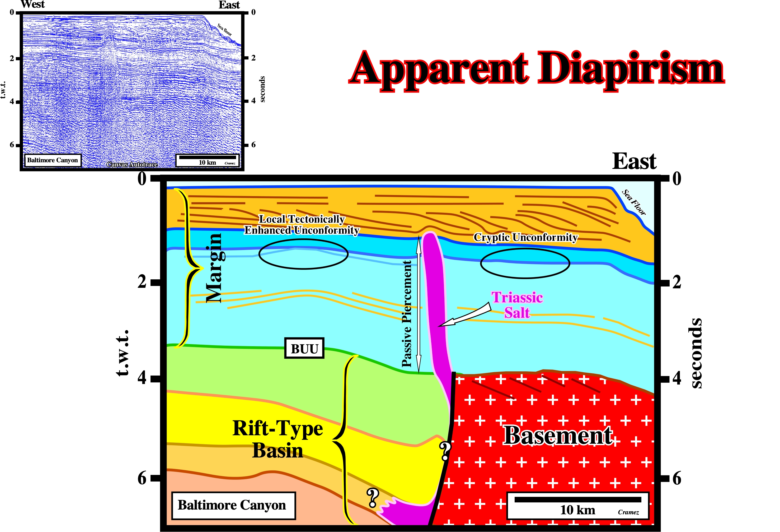
On this tentative interpretation of a Canvas autotrace of a North Atlantic Continental Margin (New Jersey offshore), the upward movement of the Triassic salt (deposited in a rift-type basin) suggests an apparent diapirism during the Cretaceous time (blue intervals). The salt seems to have arrived at surface at the end of the Late Jurassic, in association with the Pangea breakup unconformity (BUU). Westward of salt diapir, at the bottom of the dark blue interval, there is a local enhanced unconformity due to the emplacement of a volcanic intrusion (out but not too far of the seismic line). Such enhanced unconformity correlates, eastward of the salt diapir, with a cryptic unconformity. The Cretaceous sediments (light blue) are not disturbed by the salt movement, which seems to be an apparent diapirism. It is logical to hypothesize the upward salt movement is synchronous of Cretaceous deposition. Tertiary sediments (orange interval), characterized by a progradational geometry, show a slightly deformation at the bottom of the orange interval. Such a deformation can be due whether to differential compaction or to late reactivation of the salt.
Apparent Mound (Jackson and Cramez, 1989)
A salt driven inverted structure, in which the high structural points become low structural points. As illustrated in the geological sketch (below) the interdomal synforms become apparent mounds by complete salt reduction. Due to total withdrawal of the salt domes, the pristine depocenters become apparent mounds.
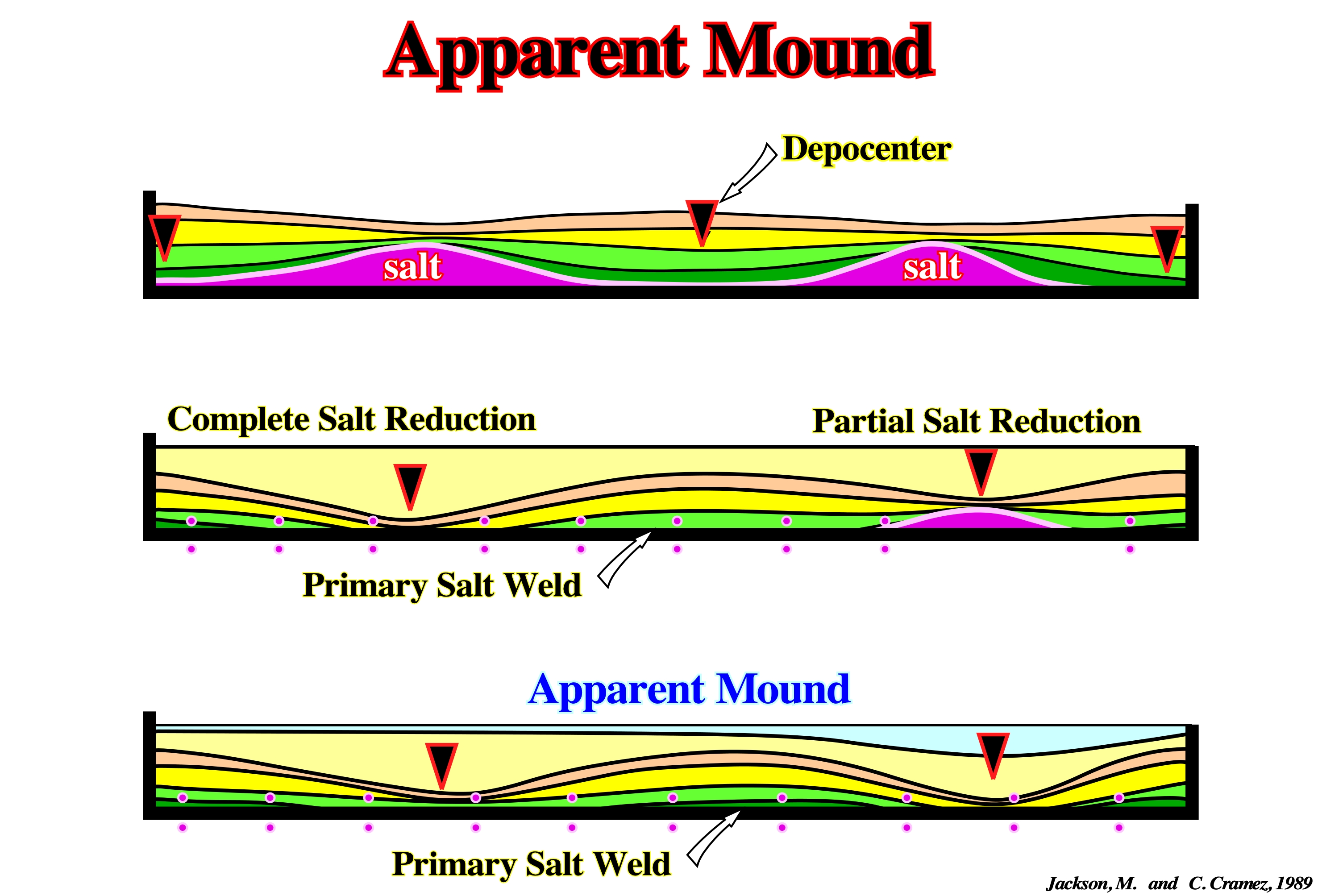
During the first phase, the migration of the salt toward the salt anomalies induce depocenters between them, which become small domes. As the salt flows away and the salt domes withdrawal, new depocenters took place where compensatory subsidence was higher, i.e., where the salt was thicker. Finally, due to a total salt reduction, a primary salt weld is formed and the older depocenters become inverted producing apparent depositional mounds.
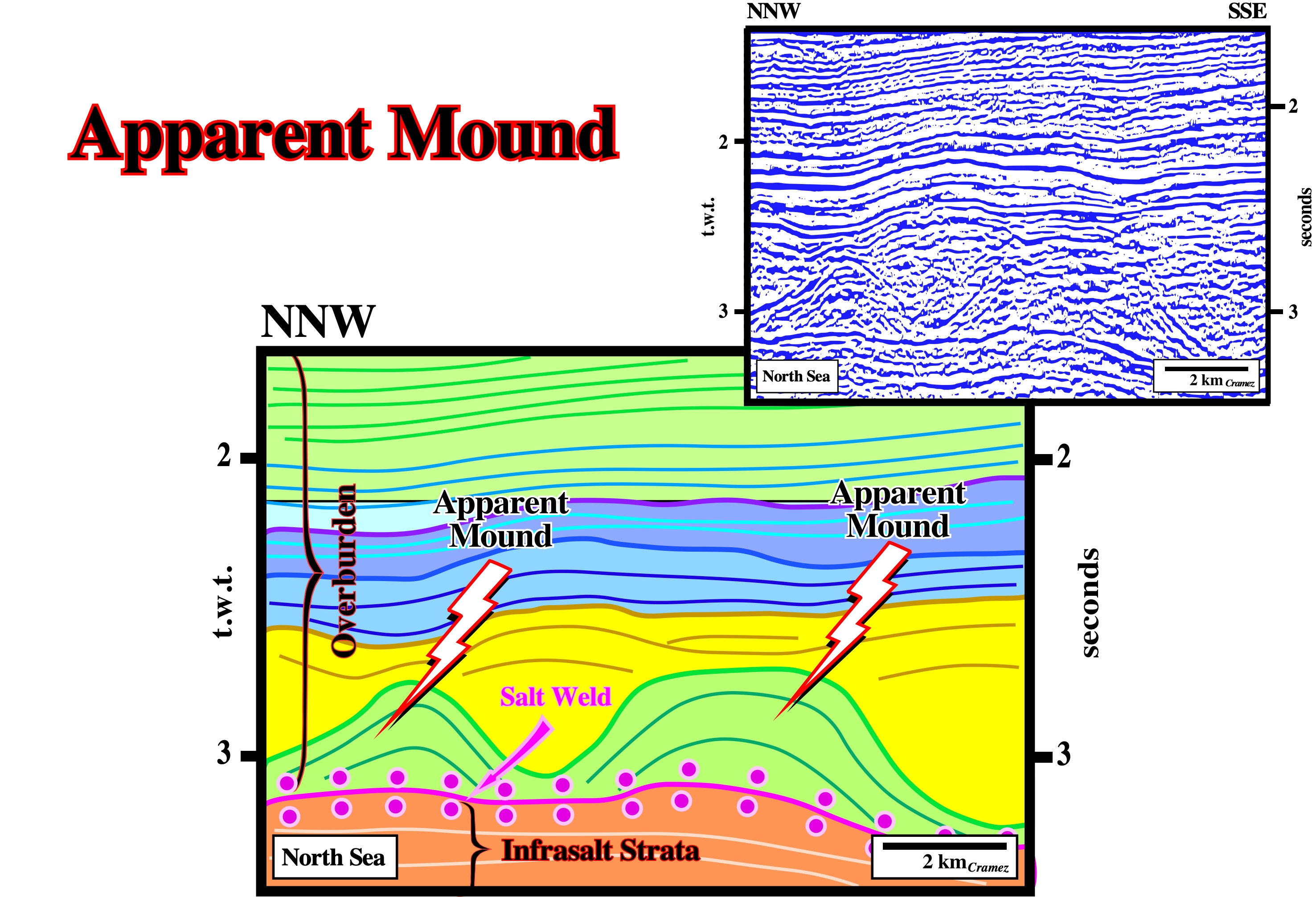
On this tentative geological interpretation of a Canvas autotrace of a North Sea seismic line, the green antiforms are apparent mounds. Initially, their geometry was that of interdomal depocenters developed between salt structures (domes or walls). Later, due to the withdrawal of the salt structures, their geometry became inverted as the yellow depocenters were deposited. At the bottom of the overburden, a salt weld is quite obvious, since the tectonic disharmony, between the cover (salt + overburden) and the subsalt strata, is rather evident. Certain apparent mounds can be interpreted as Haggis structures (inverted depocenters induced by an almost total salt reduction).
Apparent Offlap(Jackson and Cramez, 1989)
In salt tectonics an apparent offlap is the change of the original (depositional) reflection terminations of chronostratigraphic lines (bedding planes or seismic reflectors) by salt reduction. Apparent offlaps correspond, often, to tilted onlaps. The term offlap is, often, used to express either (i) the progressive withdrawal of the sea from the land or (ii) the arrangement of the strata deposited on the floor of the sea during its regression (https://www.merriam-webster.com/dictionary/offlap).
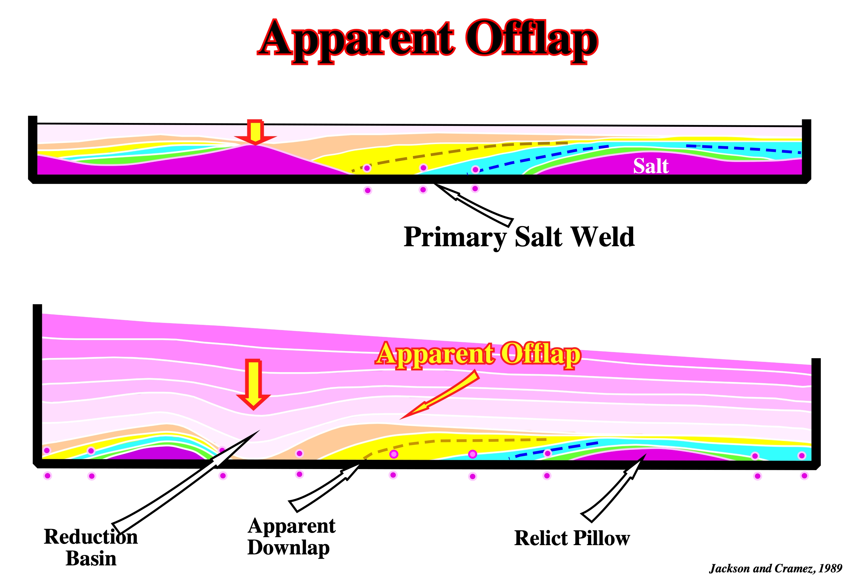
The geometrical relationships between seismic markers and seismic surfaces (defined by the reflection terminations, such as an unconformity or onlap surface) have geological meaning just when defined at the deposition time. Tectonics change the original geometrical relationships. A progressive salt flowage of autochthonous salt can induce a primary salt weld. The original onlap chronostratigraphic terminations change into apparent downlap (or apparent offlap) terminations. On seismic lines or on Canvas autotraces, the recognition of apparent offlaps and the associated salt weld surfaces are crucial to the understand of the geological evolution.
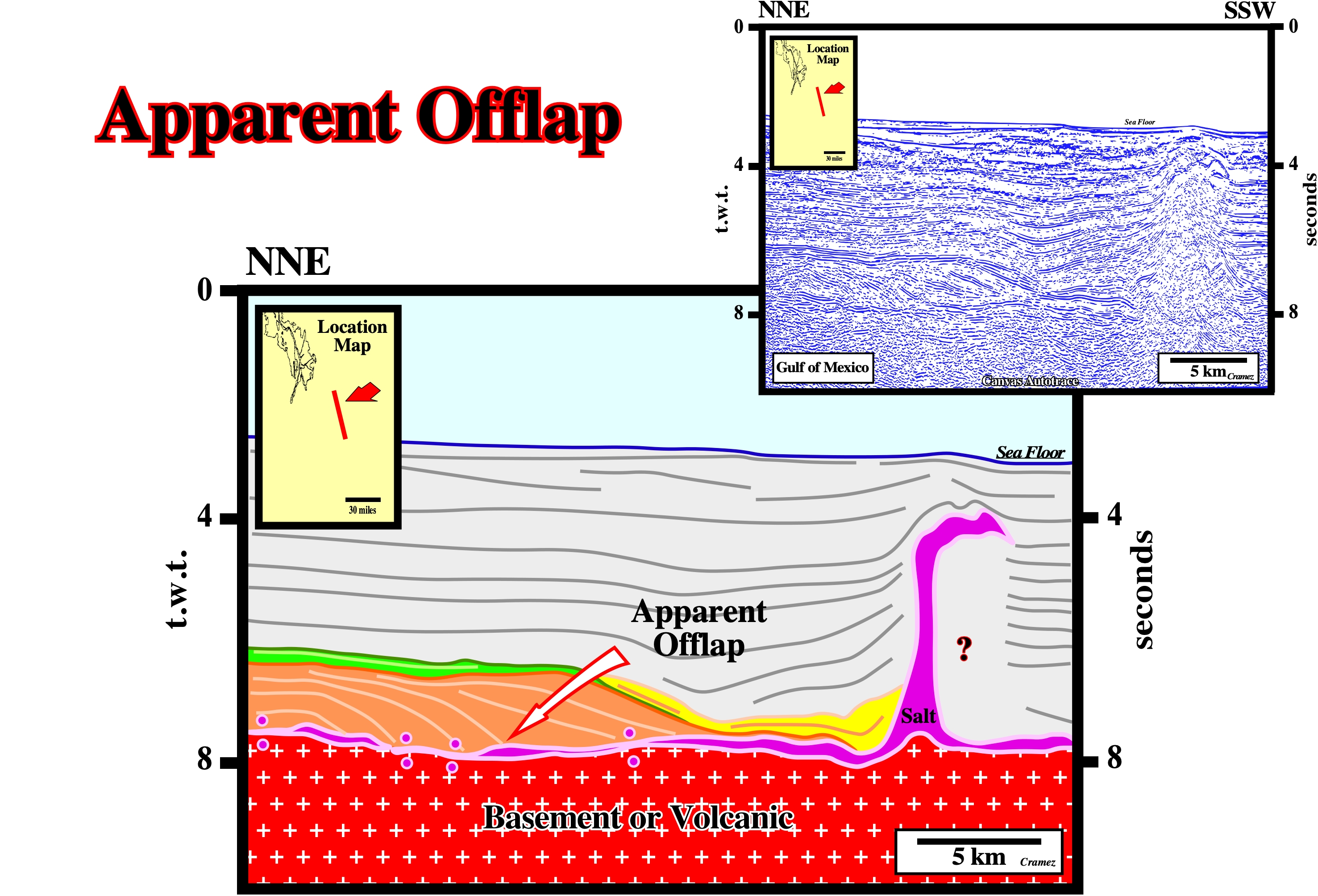
The apparent offlaps (tilted onlaps) recognized in lower part of this tentative geological interpretation of a manual autotrace of a Gulf of Mexico seismic line were, in the past, erroneously, interpreted as progradations of the Cretaceous continental slope sediments. In Geology and, particularly in Sequence Stratigraphy, offlap is a progressive seaward displacement of the updip and downdip terminations of the sedimentary units within a conformable interval of rocks. The retrogradational (backstepping) green interval, overlying the interval with an apparent progradational internal configuration (interval colored in brown) corresponds to the organic rich Upper Cretaceous interval, which seems to form the most likely generating petroleum subsystem in the Gulf of Mexico. It is interesting to notice the difference between the interpreted manual autotrace (in the center of the figure), in which the geoscientist in charge of the interpretation just draw the more important chronostratigraphic lines, and a Canvas autotrace, in the upper right corner of the figure, in which the software creates vectors from the original image.
Apparent Turtle Back Structure
In apparent turtle back structures, the main mechanism is a seaward gliding of the overburden over a salt substratum. The mechanism in turtle back structures is, mainly, an inversion induced by salt reduction. In an apparent turtle back there is just an interval thickening against the gliding surface, while in a turtle back structure, there are two divergent intervals. The older is thickening inward, while the younger is thickening outward. Back-rafts are apparent turtle back structures.
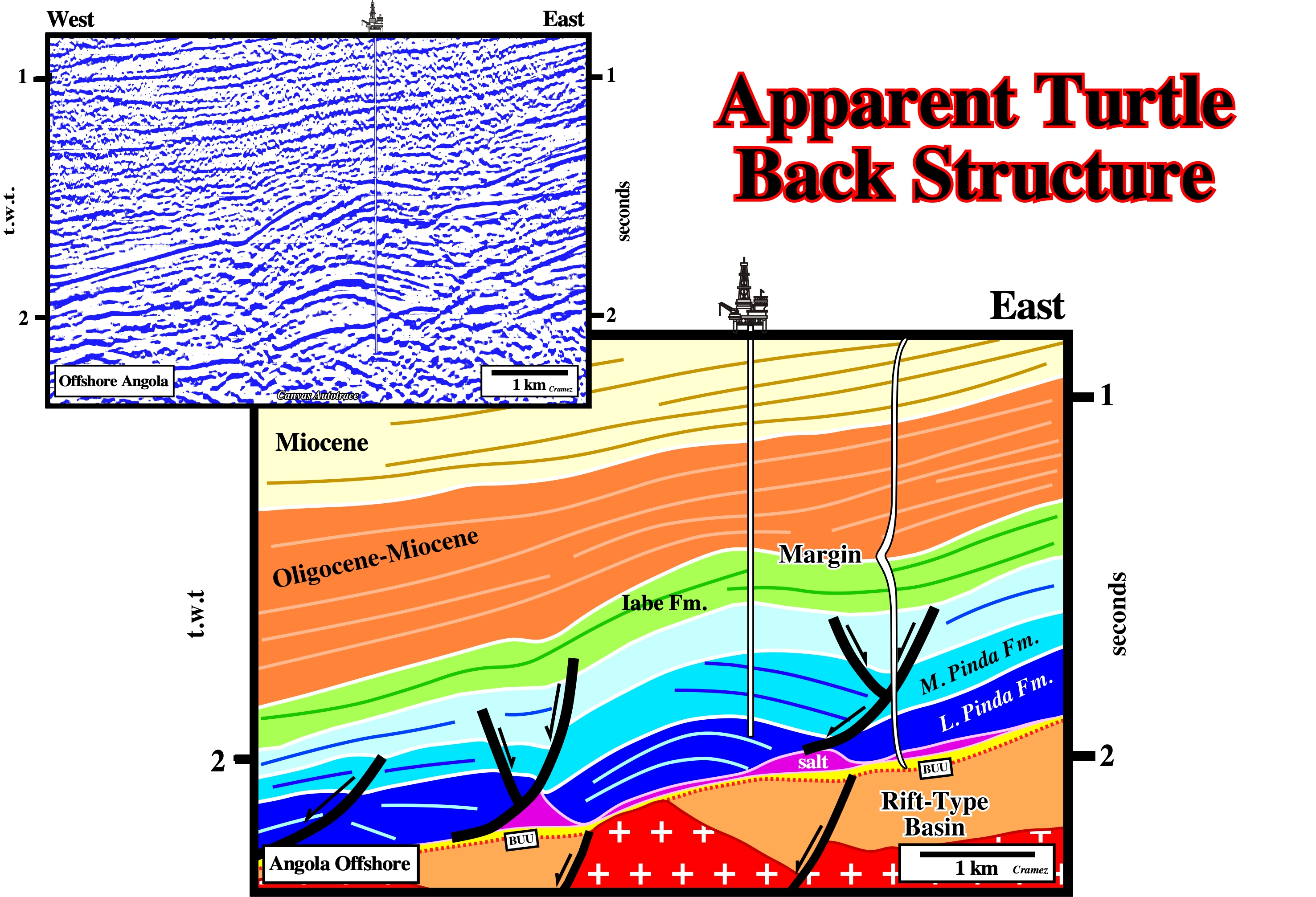
The seaward gliding of the overburden over a salt structure induced by a structural high of the subsalt strata (sometimes basement) creates a mound-like structure with apparent offlaps looking landward. These structures are often, erroneously, considered as a turtle back structures. They can evolve into true turtle back structure if, later, there is a salt withdraw in the seaward side of the structure, i.e., if the high structural point in the distal area becomes a low structural point by salt reduction or salt flowage. Obviously, the results of the well drilled on such a location were negative. The well was looking for an oil accumulation in the reservoir levels of carbonates of the Lower Pinda Formation. The well recognized just a carbonate mud without petrophysical reservoir characteristics. The reason of such a geological failure is a problem of salt tectonics. As illustrated, the blue interval (Pinda formation) is here a synkinematic interval, i.e., contemporaneous of the salt flowage, which created a compensatory subsidence favoring low-energy environments in the areas were the compensatory subsidence is important and a high energy environments where the compensatory is almost non existent (structural high points favoring reservoir facies deposition). A late total salt evacuation inverted the original divergent structure. The high structural points (where reservoir facies have a chance to be deposited) becomes a low structural points and the original low structural point (areas of too much compensatory subsidence favoring calcareous mud deposition) become high structural point. The well targeted a structural high point of a an interval with a divergent internal configuration. Consequently, it did not found any reservoir facies. Theoretically, we can say, in salt basins with important halokinesis to find high energy carbonate reservoir facies, the exploration wells must target the present-time low structural points of, relatively, thin intervals with an internal configuration almost parallel (small or non-existent compensatory subsidence, i.e., high energy environment). The next wells drilled in this area were successful and corroborate the advanced geological conjecture.
Aquifer (McNeill L. et al., 1999)
A body of rock containing sufficient saturated permeable material to conduct groundwater and to yield significant quantities of water to wells and springs. An aquifer test is a test involving the withdrawal of measured quantities of water from, or addition of water to, a well and the measurement of resulting change in head in the aquifer both during and after the period of discharge or addition.
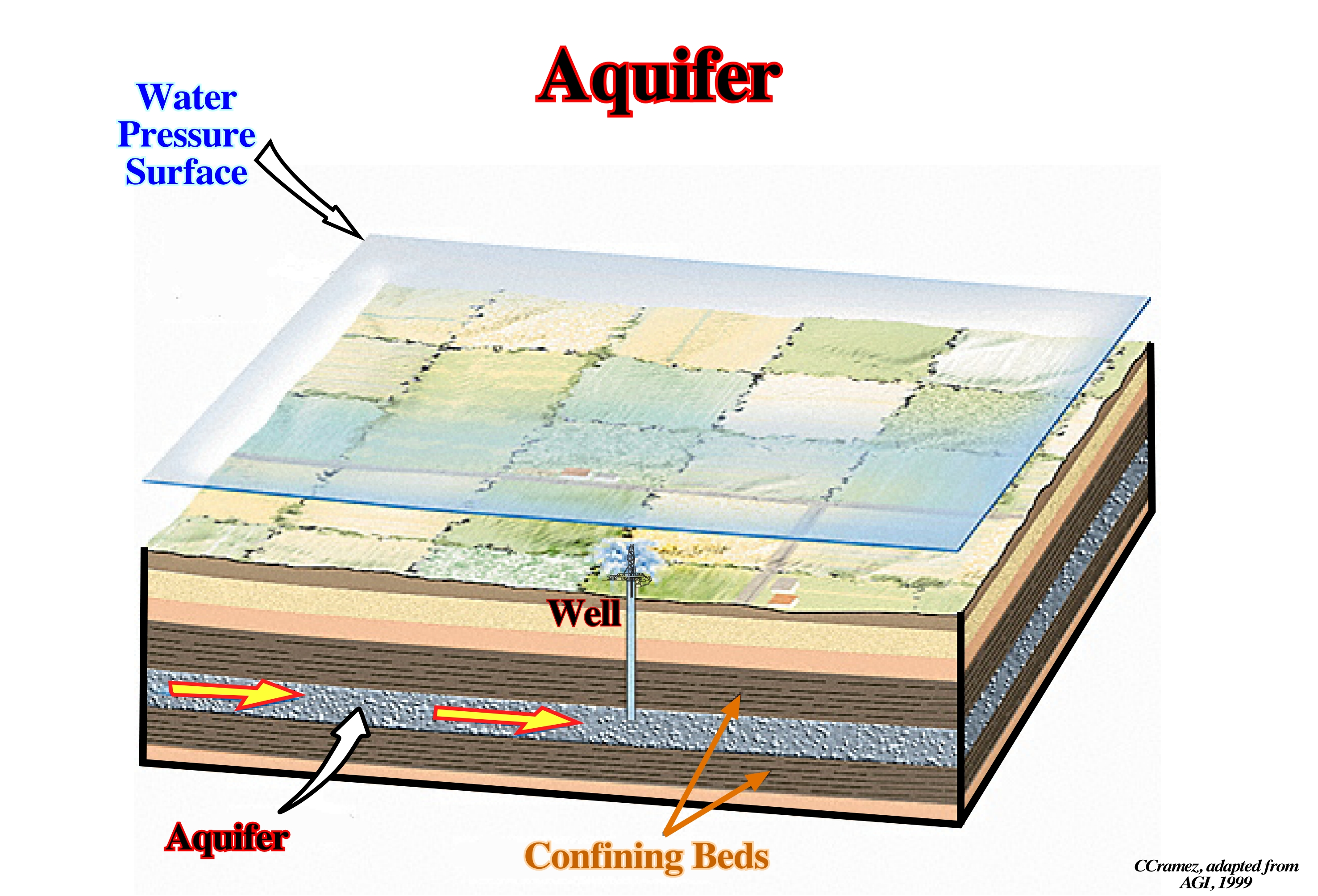
Aquifers are, sufficiently, porous or fissured reservoir rocks to store large amounts of water and, sufficiently, permeable so that water can circulate freely. In salt basins, as in North Sea, aquifers can play an important role since the salt layer can be, completely, dissolved (see dissolution). Similarly, in hydrocarbon basins, the aquifer's movement (hydrodynamism) can favor, or destroy, the trapping of hydrocarbons. Geoscientist working in oil companies should not forget that in an important oil field there are, always, three main trapping components: (i) Stratigraphic ; (ii) Structural and (iii) Hydrodynamic.
Argilokinesis
A form of shale tectonics, in which the shales, generally, undercompated, flow by gravity, i.e., by release of gravity potential energy alone, in absence of significant tectonic stress. Synonym of shalokinesis. Argilokinesis is, particularly, frequent and quite important, in association with delta and prodelta environments, as in Gulf of Mexico and Gulf of Guinea, for instance.
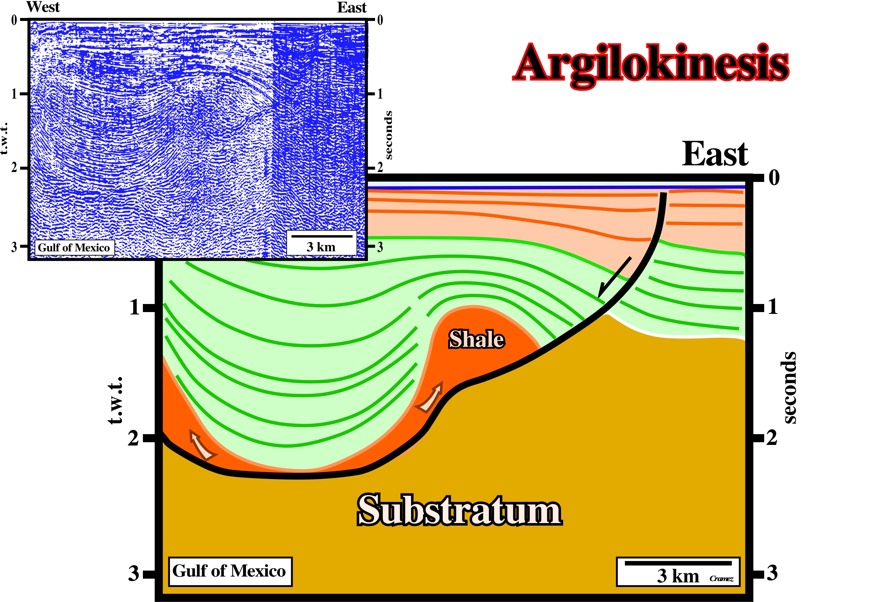
This rollover structure (syndepositional antiform developed within the hangingwall of large listric normal faults) was developed in the hangingwall of a growth fault created over mobile substratum (western flank of a large shale dome). On seismic lines or Canvas autotraces, the fault plane of the growth fault is underlined by a strong negative reflector induced by the impedance contrast between the synkinematic sediments and the undercompated shales. As in halokinesis, there is always a tectonic disharmony associated with shalokinesis. The sediments above the tectonic disharmony are deformed, while sediments the substratum are more or less undeformed.
In Gulf of Guinea, argilokinesis is paramount. It creates antiform structures (extension). This area is a realm of listric faults. The updip extension (continental platform and continental slope) induced by gravity gliding, is compensated, down-dip, by local compressional structures (shortening) with a westward vergence, as illustrated on the tentative geological interpretation of the Canvas autotrace of a regional seismic line. The anticlines and the reverse faults with an eastward vergence, located in south-western end of the Canvas autotrace, belong to a different faulting system. They are associated to a compressional tectonic regime (σ1 horizontal) created by oceanic ridge push.
Arkose (McNeill L. et all, 1999)
A feldspar-rich sandstone, commonly, coarse-grained and pink or reddish, that is, typically, composed of angular or subangular grains that may be either poorly or moderately well sorted. It is, usually, derived from rapid disintegration of granite or granitic rocks. Often, they closely resembles granite, as for instance, the Triassic arkoses of Eastern United States.
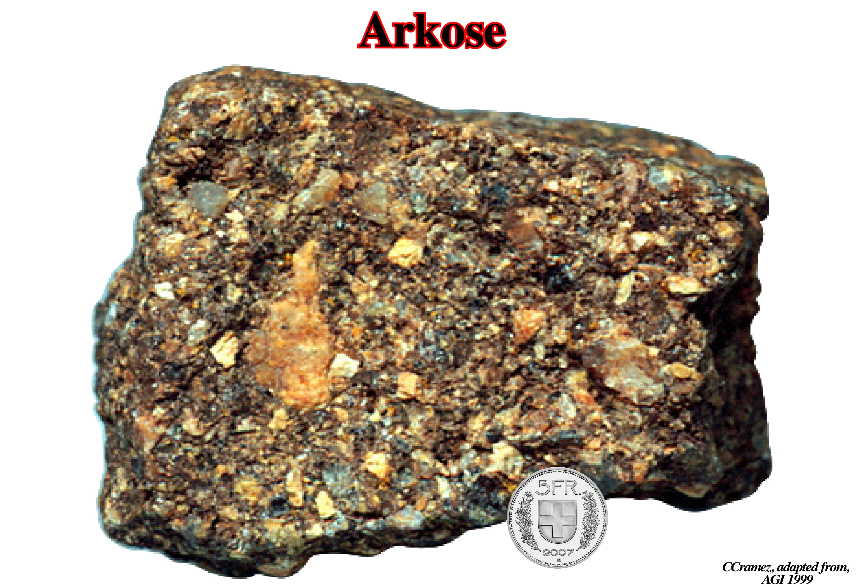
Like all sandstones, arkose is a detrital rock rich in quartz (up to about 60%), but defined by a proportion of feldspar of at least 25%, possibly accompanied by some micas and a cement composed of clay (about 15%). It is a coarse, feldspathic sandstone. Moreover, its cement is clayey, and not calcareous, which increases its resistance to the rain. In petroleum geology, arkoses are considered as a potential reservoir-rocks, since, very often, their feldspars are dissolved out by the action of a percolating liquid.
Asymmetric Intrusion
Synonym of one-sided piercement.
On this tentative geological interpretation of a Canvas autotrace of an Angola offshore seismic line, the original asymmetric salt intrusion (one-sided piercement) is spite of the two salt expulsion basins (a large one and small one filled by sediments coloured in dark green). The growth fault limiting the major depocenter is also, easily, recognized. Such a fault was the eastward limit of the original one sided piercement.
A-type Subduction Zone
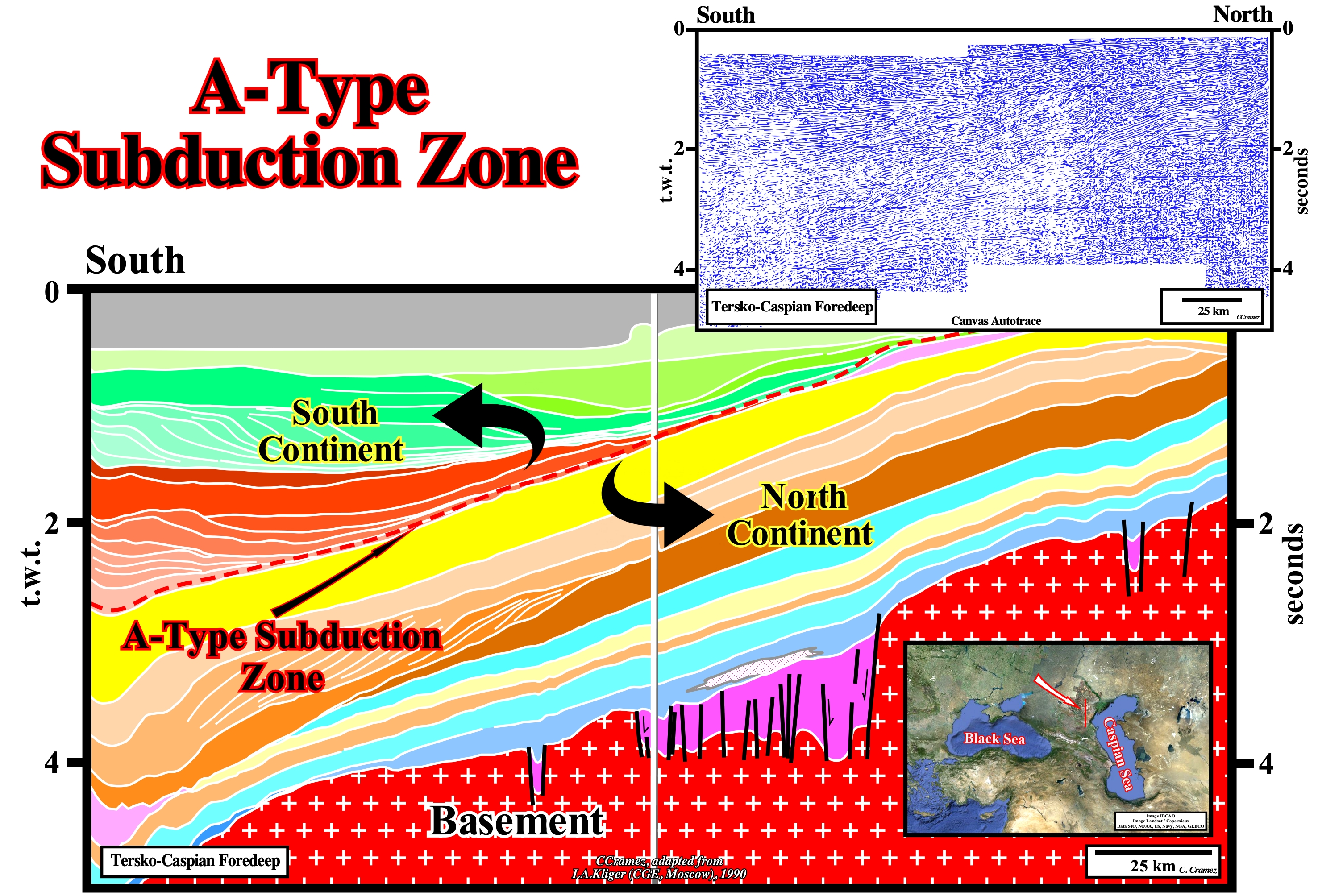
As we can see on this tentative interpretation of a Canvas autotrace of a regional seismic line of Tersko-Caspian foredeep, the presence of two major downlap surfaces with opposite vergence, strongly, suggest the closure of an ocean (Tethys Sea) in association with the collision between two lithospheric plates. The upper progradations, with a northward vergence, emphasize the southern continent (southern margin of the Tethys Sea), while the lower progradations, looking southward, emphasize the northern margin of the Tethys Sea. Such a collision, in which the kinematic energy does not play any role, can be considered as an A-type or Ampferer subduction zone. In fact, the southern margin of the Tethys sea (northward looking progradations) overrides the northern margin, which can be interpreted as the plunging lithospheric plate.
Atlantic Hinge Zone (Karner et al., 19998)
Prominent basement high bounded by a major west-dipping normal fault zone.
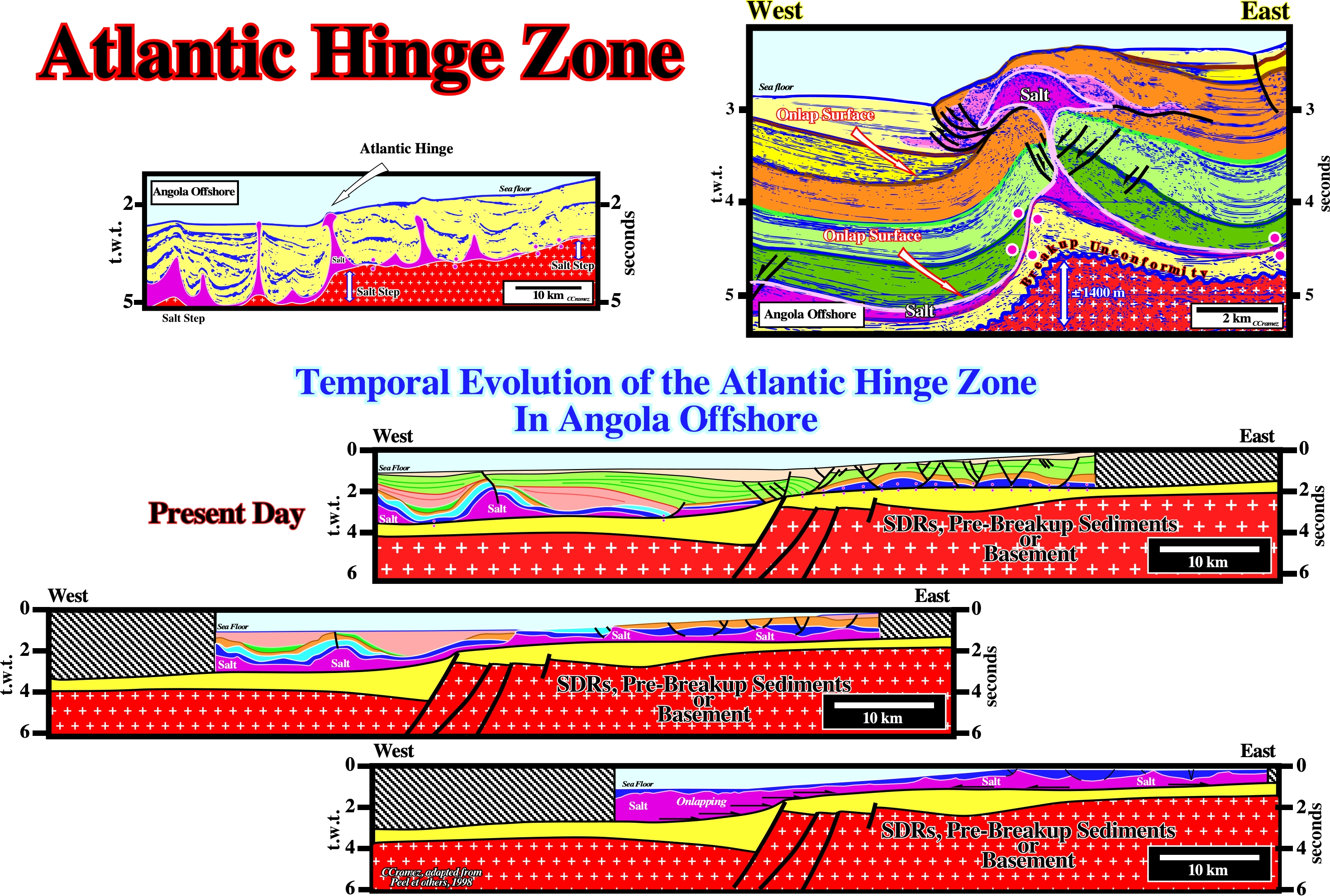
On a geological cross section of the of the Kwanza geographic basin (Angola), major basement steps define three salt provinces : (i) The Outer Kwanza Geographic Basin, where the salt thickness can reach more than 3,000 meters ; (ii) The Coastal Arch, in which the maximum thickness of the salt ranges is around 650 meters and (iii) The Inner Kwanza Basin, in which the maximum salt thickness is around 2,300 meters. The onlapping of the salt over the infrasalt strata is, naturally, more evident along the major steps. The largest basement step (around 1,,425 meters), between the outer Kwanza geographic basin and the coastal arch, defines what several geoscientists call the Atlantic Hinge Zone. On the tentative geological interpretation of a Canvas autotrace of an Angola deep offshore seismic line ((upper right corner), the major step (around 1,400 meters), on the top of the infrasalt sediments, separates the outer Kwanza geographic basin (eastward) from the coastal arch. the Atlantic hinge zone, is obvious. It is characterized by an onlap surface of the evaporites over the unconformity (erosional surface), which can be developed at the top of : (i) The margin infrasalt sediments (if they exist) ; (ii) The subaerial lava flows, which postdate the breakup unconformity ; (iii) The rift-type margins sediments or (iv) The basement. As sedimentation takes place above the salt, the salt starts to move seaward. If the sedimentation rate is insufficient to cover the bathymetric escarpment, the sediments onlap above the step and are translated basinward after deposition, producing a landward dipping package of onlapping strata. The distance from a given onlap to the step records the amount of translation. On the temporal evolution of the Atlantic Hinge zone, presently, the seismic lines westward of the Atlantic hinge zones clearly illustrate a landward dipping sedimentary intervals onlapping the intervals deposited immediately above the salt (lower sketch). The proposed reconstitutions (middle and upper sketches), strongly, suggest not only a significant seaward depocenters, but an onlapping of the salt fossilizing the presalt step.
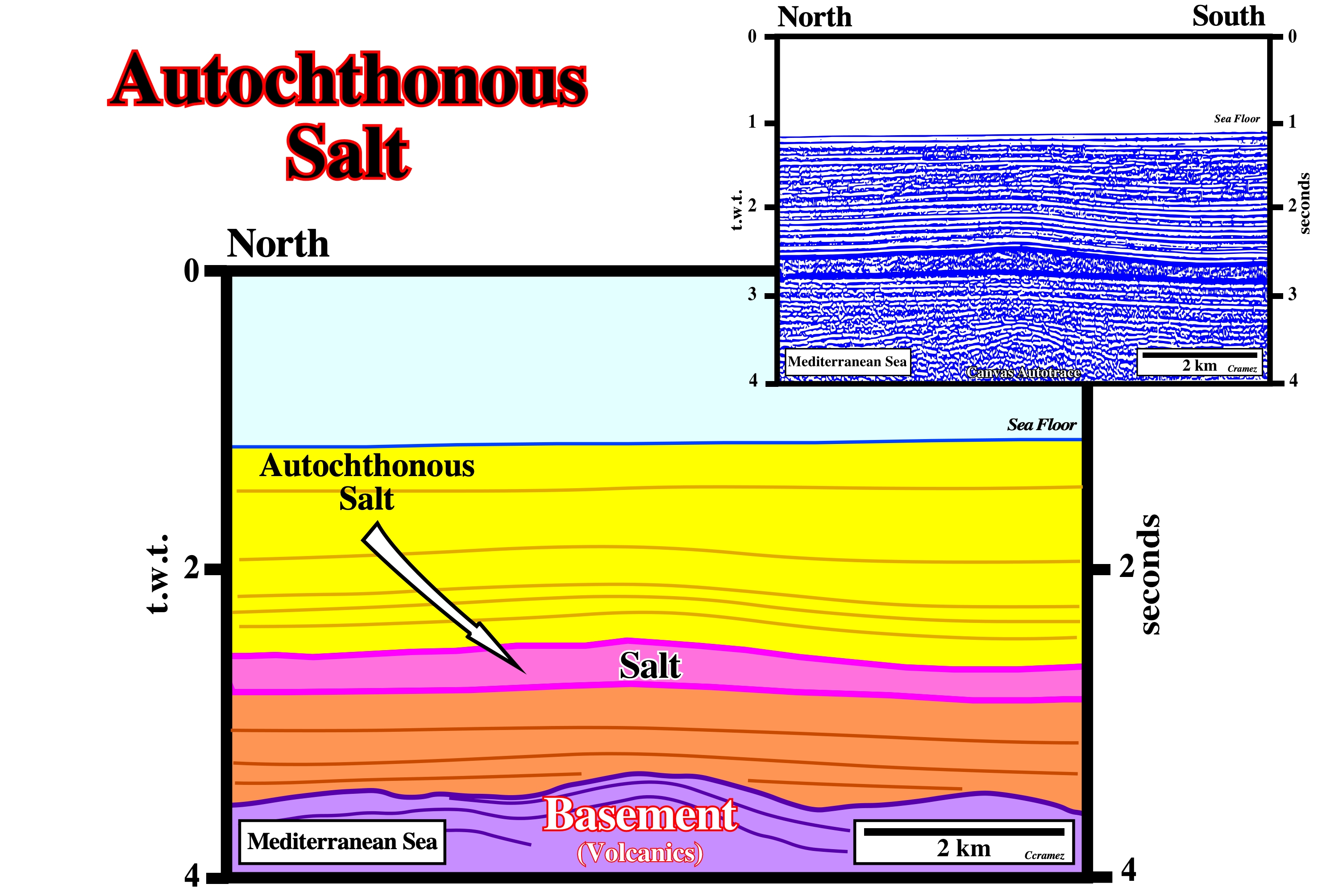
Autochthonous Salt
A salt body resting in the original strata or surface on which it accumulated by evaporation. Autochthonous salt is in its stratigraphic position.
The salt layer (Messinian salt) visible on this preliminary tentative geological interpretation of a Canvas autotrace of a Mediterranean seismic line, is an autochthonous salt layer. It is in its real stratigraphic position. The Messinian salt was deposited in association with the drying of the Mediterranean sea, which seems to be rather of tectonic origin than a consequence of the Plio-Pleistocene glaciation. The drying was, probably, due to the gradual closure of the Strait of Gibraltar as a result of the northward movement of the lithospheric African plate. This closure prevented eustatic rebalancing with the Atlantic Ocean and led, locally, to a drop of the relative sea level of about 1,500 to 2,500 meters. At the rate of 3,300 km3/year of net evaporative loss, the Mediterranean geographic basin (3.7 Mkm3) dried up roughly in 1,000 years, leaving a significant thick salt layer and rising the absolute (eustatic) sea level around 12 meters (the evaporated water reached the oceans when it fell as rain or snow). Note that the absolute sea level, contrariwise to the relative sea level, is referenced to a fixed point, which is, generally, the Earth's center.