
Oblique Inversion (Letouzey, J. et al.,1995)
Inversion associated with a strike-slip movement. Oblique inversions are associated structures with en-echellon folds and faults. Examples of oblique inversions can be found along the Saharan flexure, which separates the Atlas domain from the Saharan platform. The Atlas domain is a typical folded and uplifted inverted graben above thick salt. In addition to conventional inversion structures such as forced folds over the basement faults, a strike-slip component forms en-échellon folds in footwalls of basement folds. Fold axial traces are slightly oblique to the flexure and are crosscut by synthetic crestal tear folds. Within the Atlas domain, folds that are unrelated to basement fault inversion or diapirism trend perpendicular to the regional Tertiary compression.
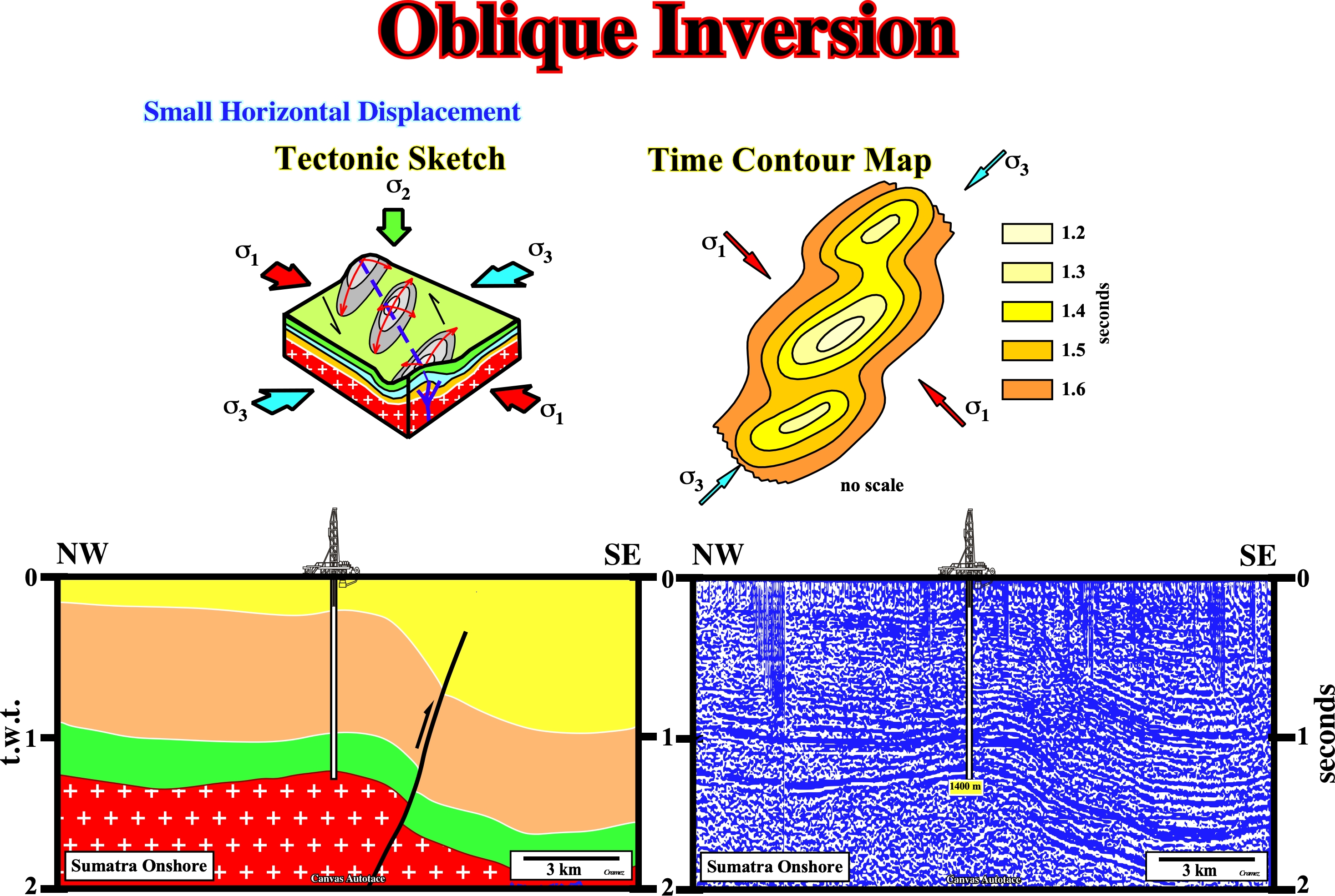
On this tentative geological interpretation of a Canvas autotrace of a Sumatra onshore seismic line, an oblique tectonic inversion is quit evident. Normal original normal fault of the basement (the green and brown interval thicken toward NW) played, later, as a compressional clockwise strike slip faults, in which the western block was uplift. The sediments were shortened not only by faulting (reverse faulting) but by folding (conical folds) as well , as illustrated in the above geological model .
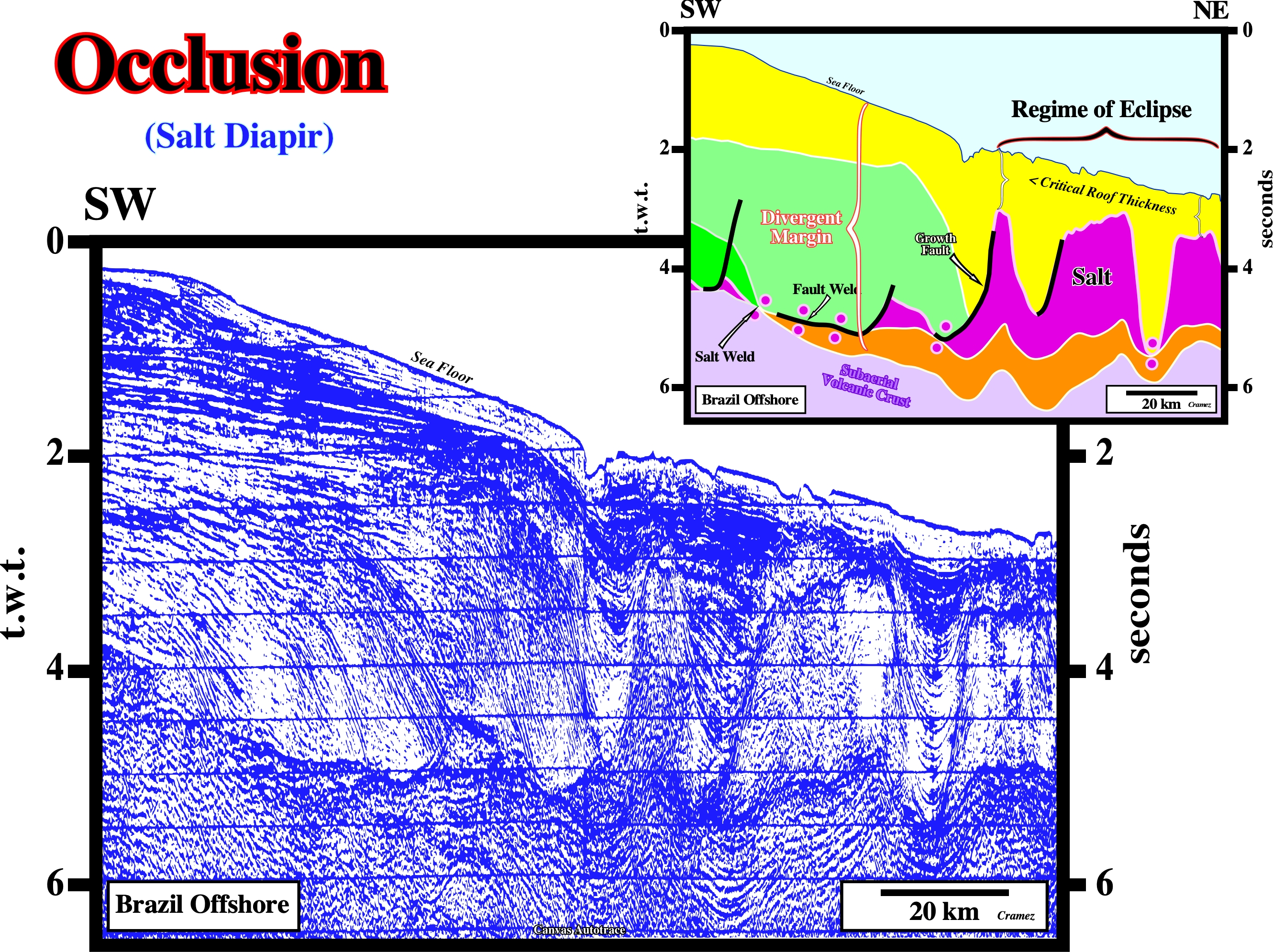
Occlusion (Talbot, C. J., 1995)
Occlusion of a salt diapir can occur by roof thicker than critical thickness. Burying diapirs deeper than their critical roof thickness not only eclipses passive diapirs but also occludes them until they are incapable of piercing actively. Until occluded salt bodies are dissolved at depth, they maintain their potential to pierce actively if their denser overburden is ever thinned by erosion or deformation.
This tentative geological interpretation suggests the roof of the salt diapirs are under the critical thickness. The salt diapirs are in a regime of eclipse : salt diapirs when buried to depths less than their critical roof thickness are referred as being in regime of eclipse. Eclipsed diapirs may appear static and dead but could still grow by active upbuilding and pierce their overburden roofs.
Oceanography
The study of the ocean, including its physical, chemical, biological and geologic aspects. Synonym of oceanology.
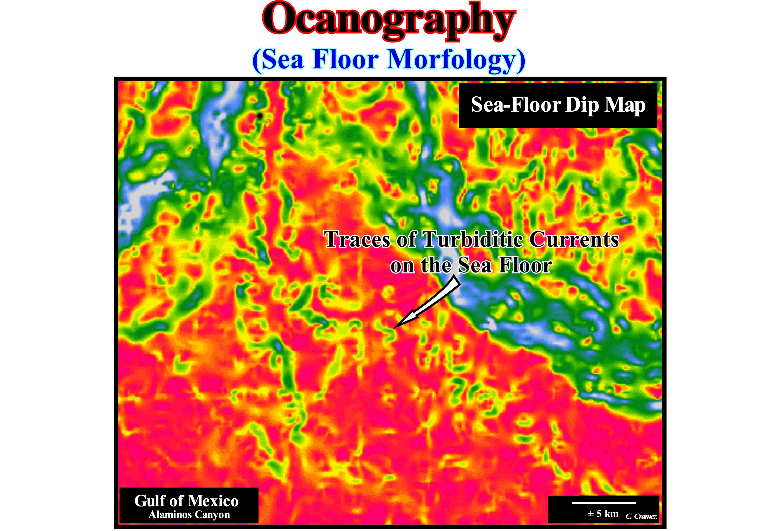
The oceanographic study of the sea floor suggested the ocean floor includes the various forms of relief existing in the land crust regions that are covered by the oceans: (i) Continental Platform (shelf), i.e., the bottom portion of the oceans that reaches, on average, 200 m water-depth and one variable width and that is covered by sediments of continental origin brought by rivers, winds, waterfalls and glaciers, which implies the existence of great concentrations of mineral resources : (ii) Continental Slope, corresponding to the intermediate portion covered by sediments ; (iii) Abyssal Plain, which is the deeper and, more or less, flat region of the oceans ; (iv) Oceanic Trench, which is an abyssal depression created by the B or Benioff type subduction zones and (v) Mid-Oceanic Ridge, which corresponds to submarine mountain belt that extend through the ocean floor (https: //pt.wikipedia.org/wiki/Relief_ oceanic). The bottom of the sea was a place unknown until very recently. It is in the deeper parts of the oceans that lithospheric plates are formed and destroyed and where exist the largest mountain belt of the world. It is important to know the oceanic relief to be able to understand the dynamics of the planet, i.e., the formation and destruction of lithospheric plates and the formation of islands. The oceanic relief is in constant transformation and movement. It is considered oceanic relief the part of the crust that is submerged by the oceans and is denominated of oceanic crust. This image depicts the seafloor of a sector of the Gulf of Mexico (USA) continental slope. Basically, it underlines the changes of the inclination of the seafloor, which gives important insights into the morphology of recent turbidity currents. In a more or less regular, but not periodic, turbidity currents flow along the continental slope and transport the sediments into the deeper parts, where they are deposited, within the sequence-cycles, lowstand systems tracts of the subgroups, i.e., submarine basin floor fans (SBFF) and submarine slope fans (SSF). The submarine slope fans (SSF) are, generally, formed by natural marginal dikes (overbank deposits with the "gull wing" structures of P. Vail) and the filling of the depressions between them or the filling of turbiditic channels (in this case of an evident erosion.) Submarine basin floor fans are, generally, formed by, more or less, important sandy lobes. A close observation of the patterns of the turbidity currents (zigzags indicated by the arrow), in this figure, clearly shows the downdip course of the currents along the continental slope is not rectilinear but meandriform. Unlike what happens with the flow of a river, a turbidity current flows within a water-bods and not at the surface of it. Thus, a curvilinear flow geometry is explained in a very different way: (i) When the density of the turbidity current is much greater than the density of the water-body, in which it flows (which means that it carries a lot of sandy material), the trajectory is, practically, rectilinear ; (ii) When the density of the current turbidity is, more or less, equal to the density of the water-body (stream with little sandy material), the trajectory of the flow as a meandering geometry. It is therefore not very logical to interpret the fillings of turbidite meandriform patterns as potential reservoir-rocks on seismic data unless the filling is very late and in retrogradation (when the relative sea level, i.e., when measured to a the local reference point such as the sea floor, is already rising), as appears to be the case in certain Angola offshore oil fields. Theoretically, and according to the P. Vail turbidite systems model, this suggests the submarine basin floor fans (SBFF) are induced by dense and, more or less, rectilinear turbidite currents (rich in sandy material), while the submarine slope fans (SSF) are associated with low density turbidite currents (rich in clayey material). If this is true, the model proposed by E. Mutti is more difficult to refute, since Type-I turbidites are induced by very dense, sand-rich turbidite currents, whereas Type-II turbidites are associated with smaller currents carrying almost exclusively shaly material.
Oceanic Basin
The sedimentary basin bottomed by oceanic crust. The large surface of such a basin is starved. Oceanic basins are almost exclusively filled by water, i.e., they are the infrastucture of the oceans.
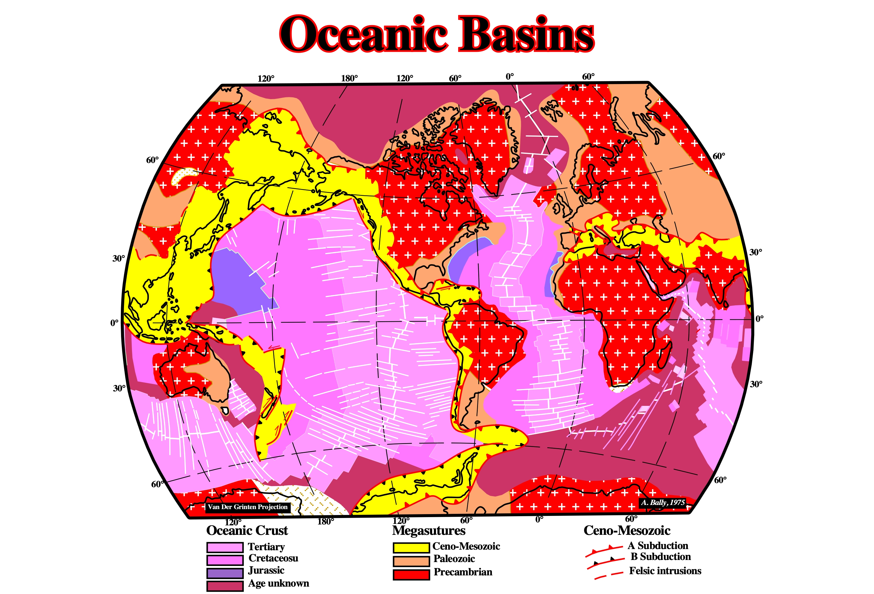
The map of the oceanic crust represent roughly that of the oceanic basins, which are at 99% filled by water. The fact that the bottom of the oceanic basins is the oceanic crust is quite important. Indeed, due to movement of the lithospheric plates, the volume of the basin changes with time. However, as the water volume, in all its forms, is assumed to be constant since the Earth's birth, every time the volume of the basin increase, the global sea level falls. Contrariwise, when the volume of the basins decreases, the global sea level rise.
Oceanic Ridge Push
Tectonic stress induced by the emplacement and topography of new oceanic crust at the level of the mid-oceanic ridges.
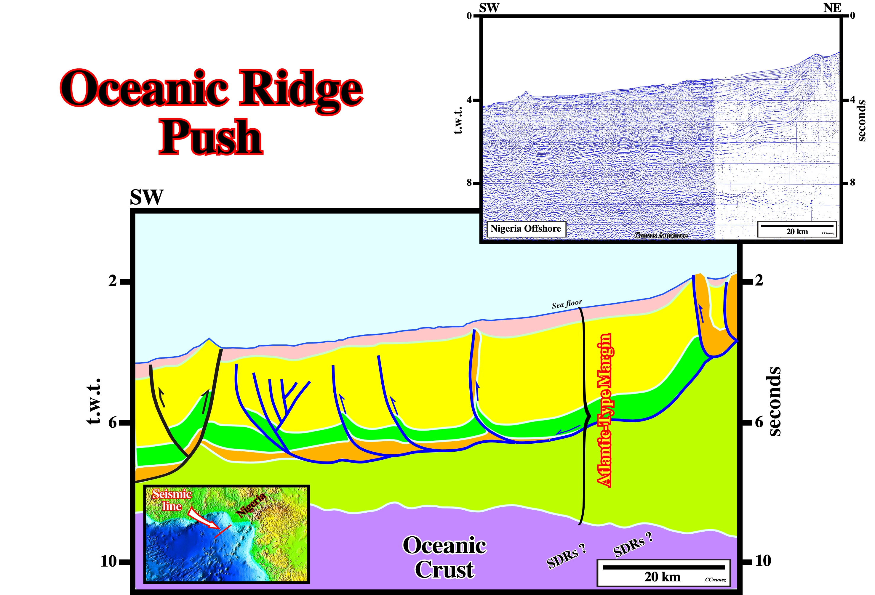
This fold-belt, located on ultra-deep offshore, in which all thrusts show a landward vergence, was created, probably, by a local tectonic stress created by oceanic ridge pushing. It cannot be explained as a counterpart of the up-dip extension so characteristic of West Africa offshores.
Offlap (Swain, 1949).
Progressive offshore regression of the up-dip terminations of the sedimentary units within a conformable sequence of rocks.
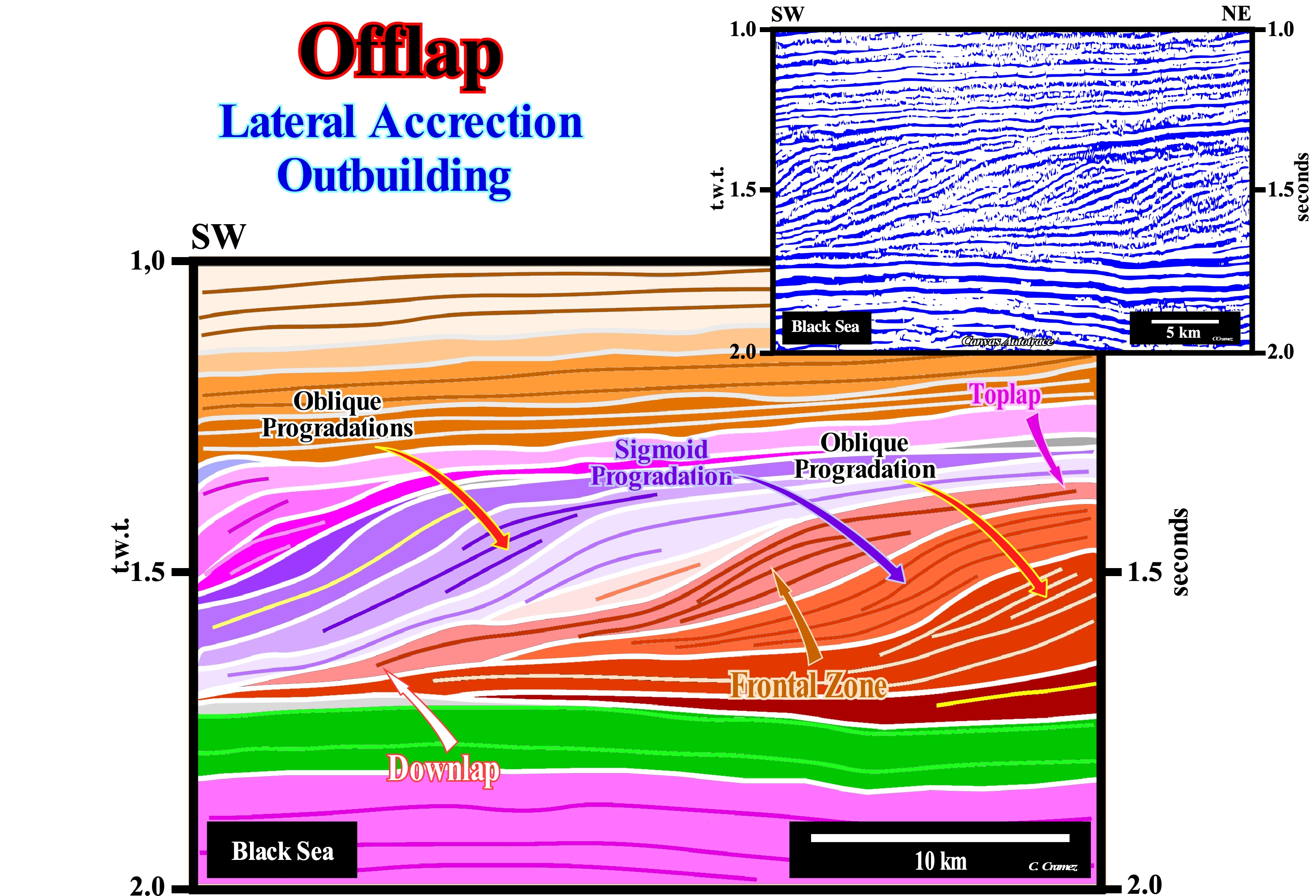
On this tentative geological interpretation of a Canvas auto-trace of a Black Sea seismic line, a regressive interval during which the coastal deposits are displaced seaward, it is recognized, easily, over an aggradational interval, probably, associated with a transgressive episode (displacement of the coastal deposits continentward). It is not difficult to verify that, in certain cases, the seaward displacement of the coastal deposits is made with a significant aggradation (upbuilding) and that in others, the aggradation, if it exists, is below the resolution of the seismic lines (more or less 30/50 m). In the former, the chronostratigraphic lines correspond to sigmoid progradations, whereas in the second cases, i.e., when the aggradation is null, they correspond to oblique progradations. The limited sedimentary intervals between two consecutive chronostratigraphic lines (the great majority of seismic reflectors), which correspond, probably, to sequence-paracycles (deposited during stability periods of relative sea level * occurring after a relative sea level rise, i.e., after a marine ingression) have, in the first case, a fusiform geometry and in the second a prismatic geometry. Within a sequence-cycle (stratigraphic cycle induced by a 3rd order eustatic cycle, which has a time-duration between 0.5 and 3/5 My), in the lowstand systems tracts group (LSTG), the coastal plain edge of the lowstand prograding wedge (LPW), which corresponds to the continental edge (upper limit of the continental slope) is, always, located downstream of the basin edge, which is the last basin edge of the preceding sequence-cycle. During highstand systems tracts group (HSTG), when sea level is higher than the basin edge, i.e., during deposition of the highstand systems tracts sub-groups (transgressive interval, TI, and highstand prograding wedge, HPW, of sequence-cycle), the shallow water deposits are deposited, by definition, upstream of the basin edge, which in these conditions coincides with the continental edge (here almost always the boundary between the platform and the continental slope). From the 1st transgressive surface, and during the deposition of the entire transgressive interval (IT), the basin edge is the border of the underlying lowstand prograding wedge . During the 1st phase of development of the highstand prograding wedge (LPW), i.e., when the basin still has a shelf, obviously, the basin edge remains the border of the lowstand prograding wedge (LPW). However, in the 2nd phase of the highstand prograding wedge (HPW), the basin no longer has a shelf, since the platform is, totally, fossilized by the progradations of the highstand prograding wedge. Thus, the basin edge becomes the new continental edge. From a lithological point of view (facies), in a stratigraphic series composed of sands and shales, the sandy horizons are predominant in the upper sub-horizontal sectors of the sigmoid progradations, whereas in the oblique progradations, they, preferentially, deposit in the upper part of the front zone dipping basinward. The term aggradational progradation is, often, used for a progradational interval, in which aggradation is significant, but, of course, without equating the seaward displacement of the coastal deposits. It is not too much to say that a progradational interval is associated with a shoreline and associated coastal deposits seaward displacement. In a clastic stratigraphic series and, especially, at the scale of a sequence-cycle, all the sequence-paracycles have a progradational geometry, since during the marine ingression, which creates the space available for the sediments, the shoreline is displaced continentward. It is during the stability period of relative sea level, which follows the marine ingression, that the shoreline moves again seaward as sediments settle down along the depositional surface in a, more or less, progradational relay geometry.
One-sided Piercement
Upwelling of salt characterized by two contrasting flanks: (1) steep, discordant flank - typically a growth fault - separating salt from thick, gently dipping strata; (2) gently-dipping, concordant flank overlain by tilted, trapdoorlike interval of sediments, which are commonly erosionally truncated and which preserve prekinematic strata.
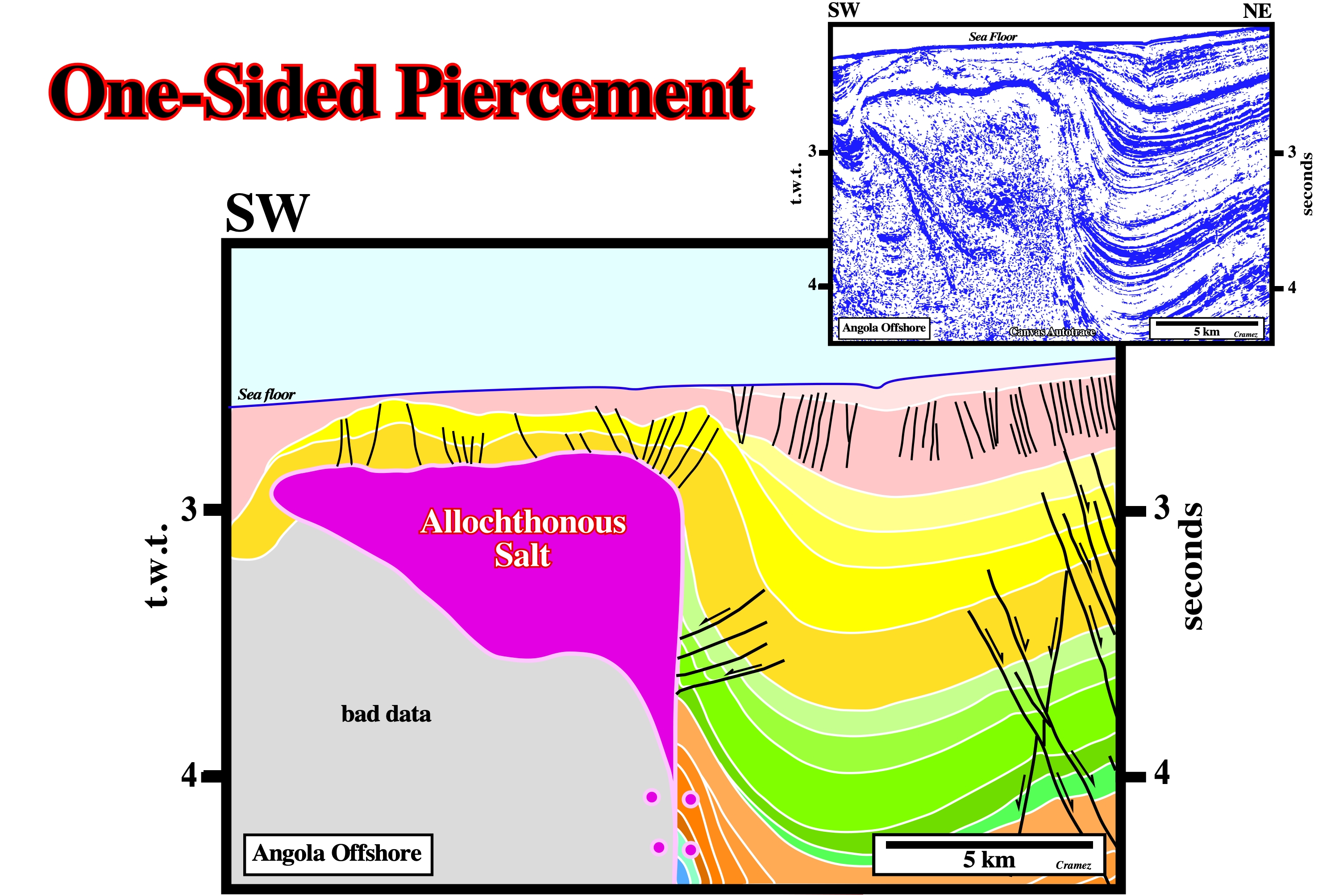
One sided piercements are frequent in deep water of West Africa in association with thrust faults created by a compressional tectonic regime induced as a counterpart of the extension regime located up-dip, i.e., in slope and upper slope environments.
Onlap
A base-discordant relation in which initially (deposition time) horizontal strata terminate, progressively, against an initially inclined surface, or in which initially inclined strata terminate, progressively, up-dip against a surface of greater initial inclination.

Onlap relationships can be coastal or marine. Both represent the aggradation induced by a relative sea level rise. With exception of turbidite depositional systems, deposition takes place when sedimentary accommodation increases.
Ordovician Salt Deposits (Zharkov, M. A., 1984)
The available information allows the recognition of a single Ordovician salt basin - The Canadian Arctic Archipelago Basin. The Canning Basin in Australia may also be Ordovician in age, but the stratigraphic position of the salt deposits occurring therein is still unknown.
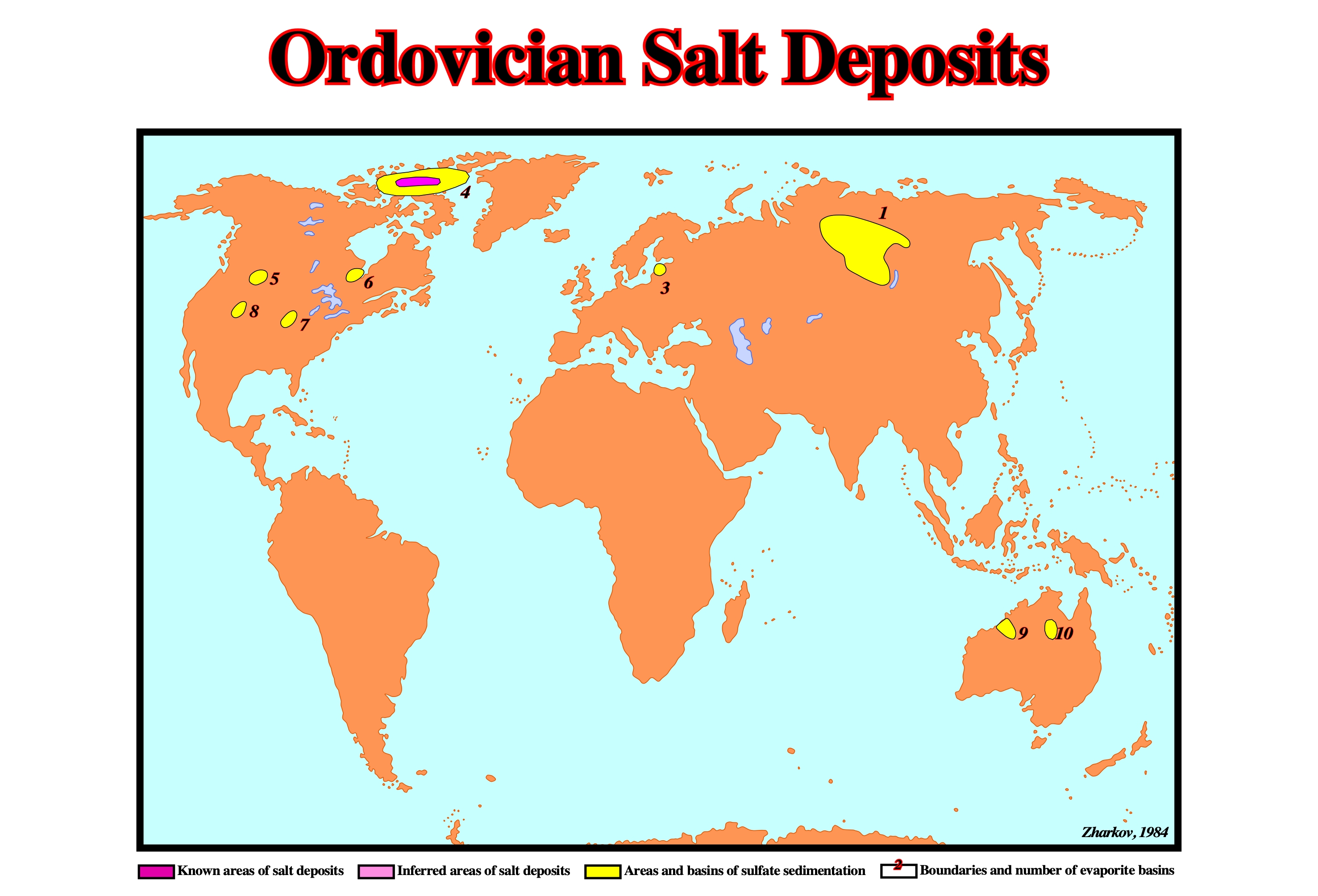
The distribution of Ordovician evaporite deposits can be summarized as follows: (1) Lena-Yenisei, (2) Severnaya Zemlya, (3) Baltic, (4) Canadian Artic Archipelago, (5) Williston, (6) Moose River, (7) South Illinois, (8) Anadarko, (9) Canning, (10) Georgina.
Origin of Salt Walls
Parallel salt walls are now though to result from linear boundary effects rather than from extra-thick source layers, as was previously supposed. The strongest and most direct boundary effects are exerted by overburden faulting or by overburden folding and the pattern of differential loading in the overburden, especially during progradation or downslope mass flow. Other boundary effects include basement-fault offset in the base of the source layer and tilted or wedge-shaped source layers or overburdens. A salt roller is the first response of the salt to non-uniform extension of the overburden.
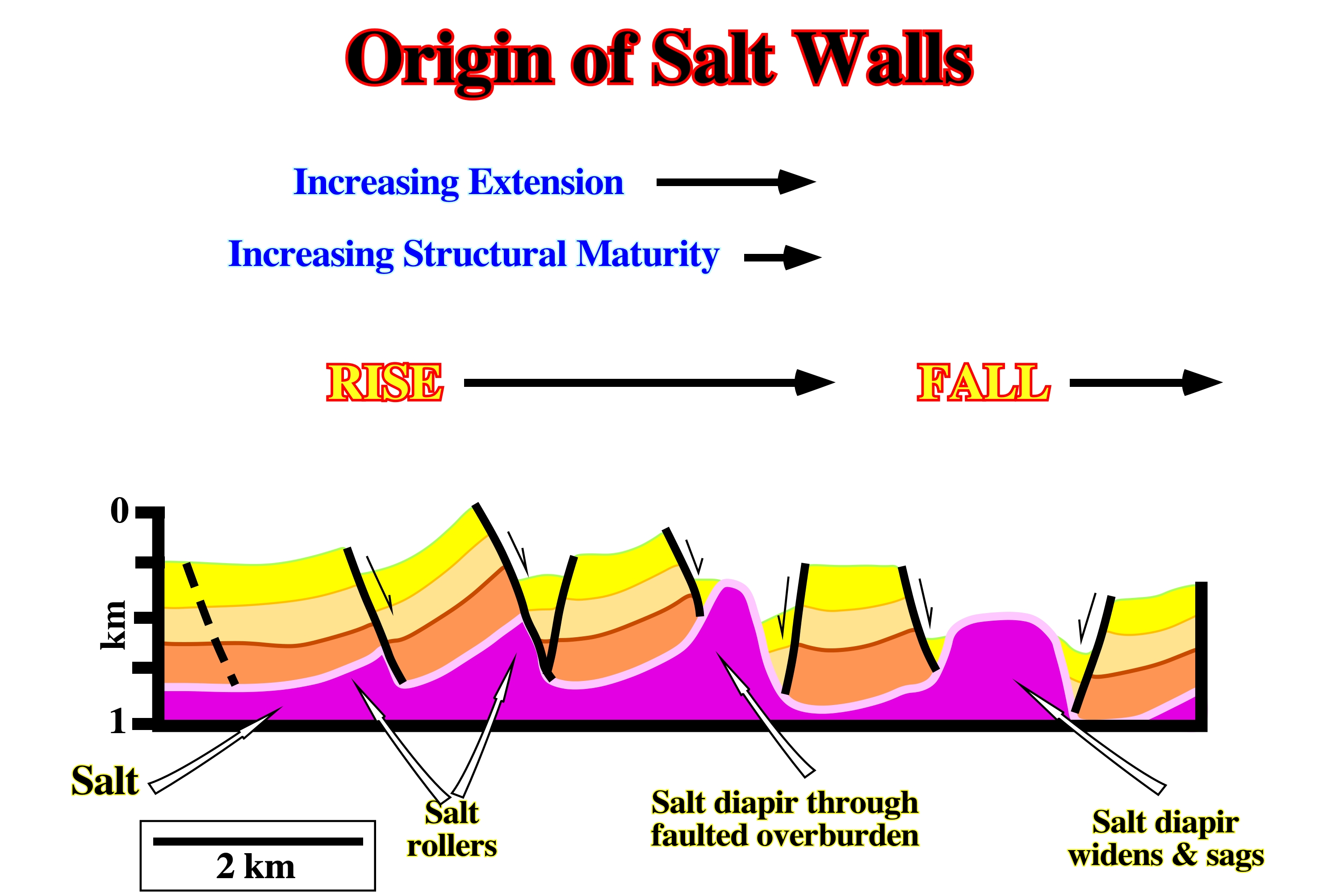
A salt roller is the first response of the salt to non-uniform extension of the overburden. A roller having a simple crest forms at the base of the footwall of a half-graben. Two roller form below a graben, one in each footwall. As extension increases, the salt diapir pierces the graben to evolve into a salt wall. With the most extreme thin-skinned extension, the overburden breaks into rafts, which can glide laterally tens of kilometers.
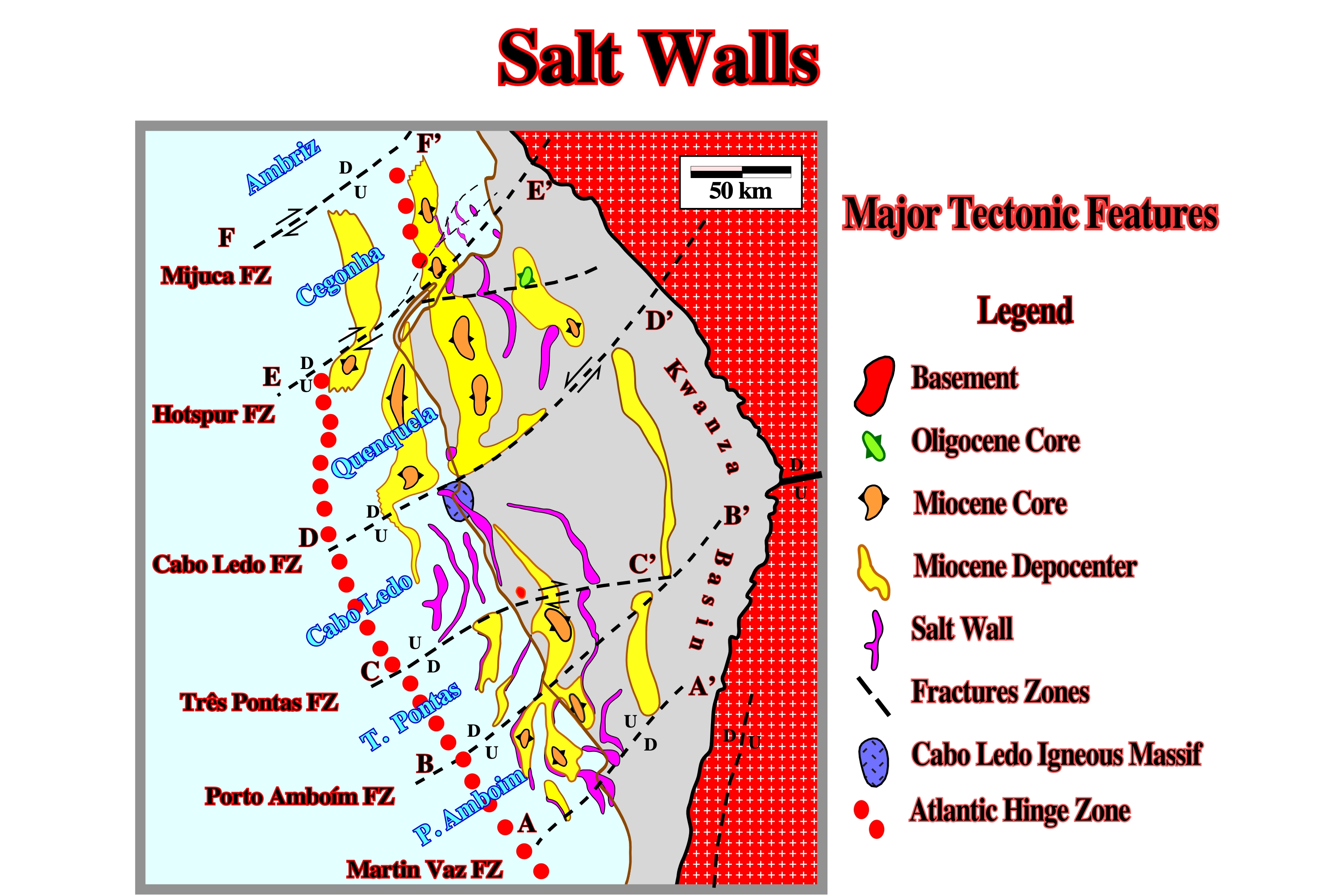
In the 70’s, Petrangol (Fina) and Total‘s geologists understood the influence of the major fracture zones in the salt tectonics of the Kwanza geographic basin. The fracture zones compartmentalize different geological provinces characterized by particular salt tectonics and petroleum systems. Indeed, a glance at the cartography of the salt walls (in purple) and the Miocene depocenters strongly emphasize the mapping of the fracture zones.
Orogenic-Belt
A linear or arcuate region that has been subjected to folding and other deformation during an orogenic cycle.
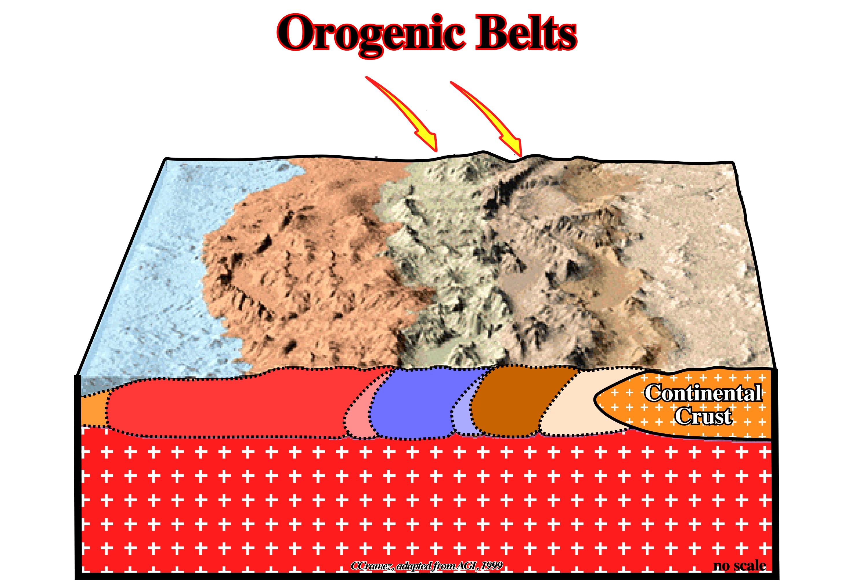
Orogenic-belts are mobile belts during their formative stages, and most of them later became mountain-belts by post-orogenic processes.
Orogenic Cycle (McNeill, L. et al., 1999)
The interval of time during which an originally mobile belt evolved into a stabilized orogenic belt passing through a (i) Preorogenic phase, (ii) Orogenic phase and (iii) Postorogenic phase. The concept has been rendered obsolete by the recognition of the lithospheric plate of the Earth.
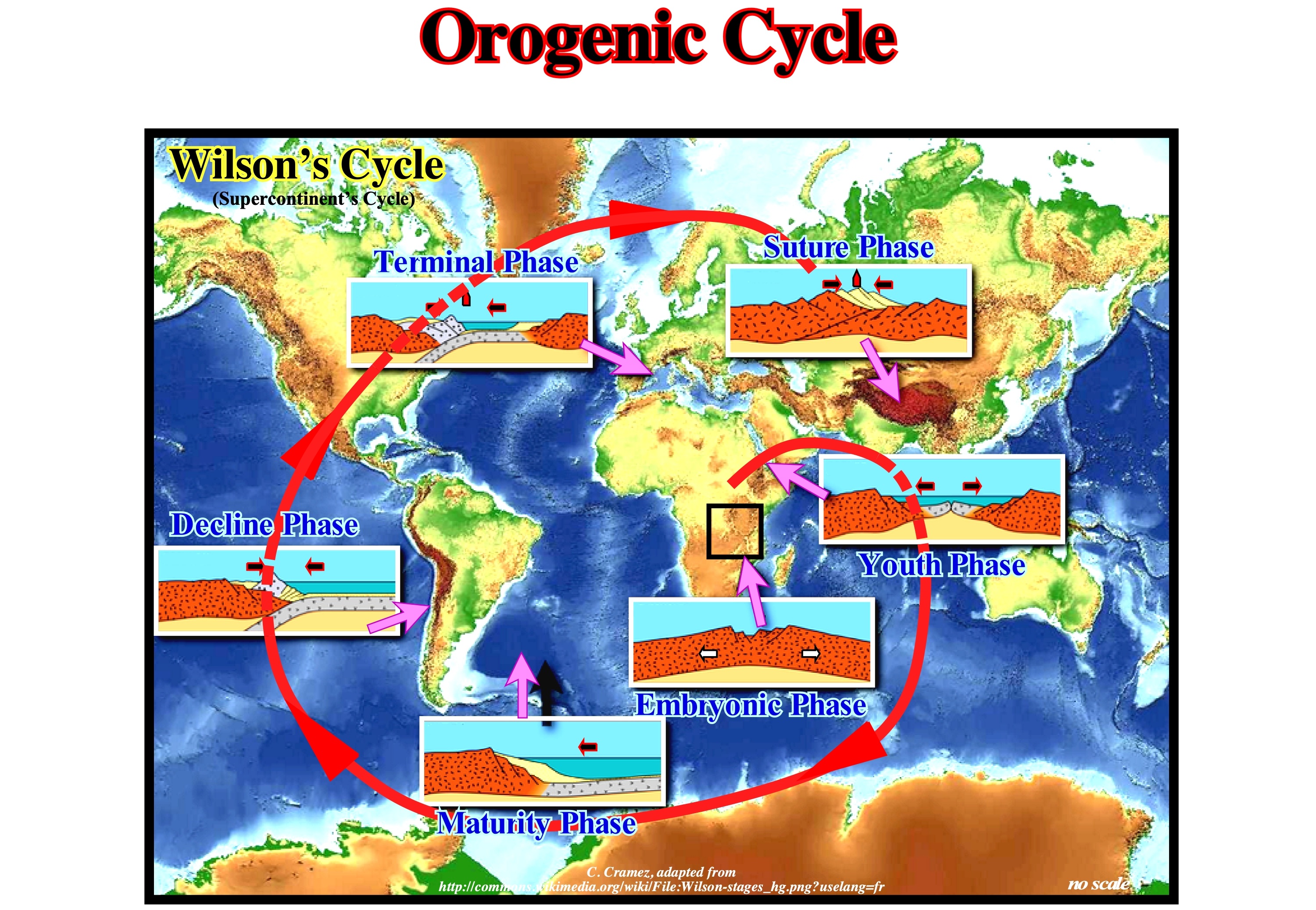
The Wilson cycle, proposed by Tuzo Wilson, explains in an orderly way the process of opening and closing of oceans, as well as, the fragmentation and subsequent formation of the supercontinents, i.e, it is synonym of orogenic cycle. Indeed, the Wilson cycle causes the formation of mountain belts and summarizes everything that happens on the continental (divergent) or convergent (or destructive) continental banks of the lithosphere. In a Wilson cycle, the following steps can be highlighted: (i) Stable Continental Craton, such as the Precambrian supercontinent Protopangea or Rodhinia (from the Russian "rodit" which means to create or to grow) ; (3) Breakup of the Lithosphere, with the creation of new volcanic crust (subaerial and oceanic) and formation of two lithospheric plates ; (4) Oceanic expansion (sea floor spreading), which, progressively, transforms the young margins into old margins due to cooling and increasing density of the oceanic crust ; (5) Subduction, that is, diving of one of the lithospheric plate (descending plate) under the other overriding plate (when the density of the oceanic crust is very high, it splits in two portions and one of them dives under the other) creating a convergent margin, with the formation a volcanic arc and the uplift of a mountains belt in the overriding plate ; (6) Divergent Margin / Volcanic Arc Collision, formed by a mountain belt, while, at the other end of the plate there is the twin divergent margin ; (7) Peneplanation of the mountain belt and new subduction of the oceanic crust with the twin margin creating another convergent margin ; (8) Collision Continent / Continent and closure of the ocean created between the two initial divergent margins and (9) Formation of a new Stable Continental Craton, i.e., the end of the Wilson cycle. This geological model reasonably explains the aggregation and fragmentation of the supercontinents (Proto-Pangea or Rodhinia at the end of the Precambrian and Pangea at the end of the Paleozoic). It explains, also, the 1st order T / R cycles associated with absolute (eustatic) sea level changes. Assuming that the amount of water (in all its forms) has been constant, since the Earth's formation (around 4.5 Ga), it is easy to understand that the global sea level is higher when the oceanic expansions are predominant (ocean basin volume decreases due to the formation and volume of oceanic ridges), and that it is lower, when the continents aggregate to form a supercontinent (the volume of the basins is maximum, since the volume of the ocean ridges is minimal). The higher order T / R cycles, i.e., 2nd and 3rd order imply geological factors other than the volume changes of the ocean basins. As the Wilson cycle is based on the plate tectonics theory, let us remember that: (A) The outer and rigid layer of the Earth, i.e., the lithosphere is a mosaic of tectonic plates that move relative to each other, with speeds of the order of a few centimeters per year (speed of growth of the nails of humans) ; (B) The plates are born at the level of the mid-oceanic ridge and they float on a plastic and warm layer of mantle called asthenosphere ; (C) The plates move away without deformation and their movement is, directly, connected to the sea floor spreading (oceanic expansion), in which the hot and melted material of the asthenosphere rises through the lithosphere to the top of the oceanic mountains (mid-oceanic dorsal) where, by cooling, it forms the oceanic crust ; (D) The new oceanic crust moves,continually, away from the axis of the mid-oceanic ridge and, as it approaches the continents, the plates are destroyed in the ocean trenches along the Benioff subduction zones (B-Type subduction), plunging into the mantle ; (E) The continents are, generally, regarded as passive objects carried by the sea floor spreading spread, however they do not remain, completely, immune to the tectonic mechanisms of the plates) ; (F) The continents (continental crust blocks) can collide and create large continents ; (G) Plate boundaries consist of ridges areas, subduction zones and transforming faults ; (H) The internal energy of the globe dissipates in the limits of the plates and the dissipation is mechanical (earthquakes, formation of the mountain, etc.) or thermal (plutons, volcanoes, etc.) ; (I) Relative motions of the plates are governed by the mathematical laws of kinematics on a sphere (the relative motion of two rigid spherical shells is, completely, described when one knows the pole of rotation, Euler pole, and the angular velocity).
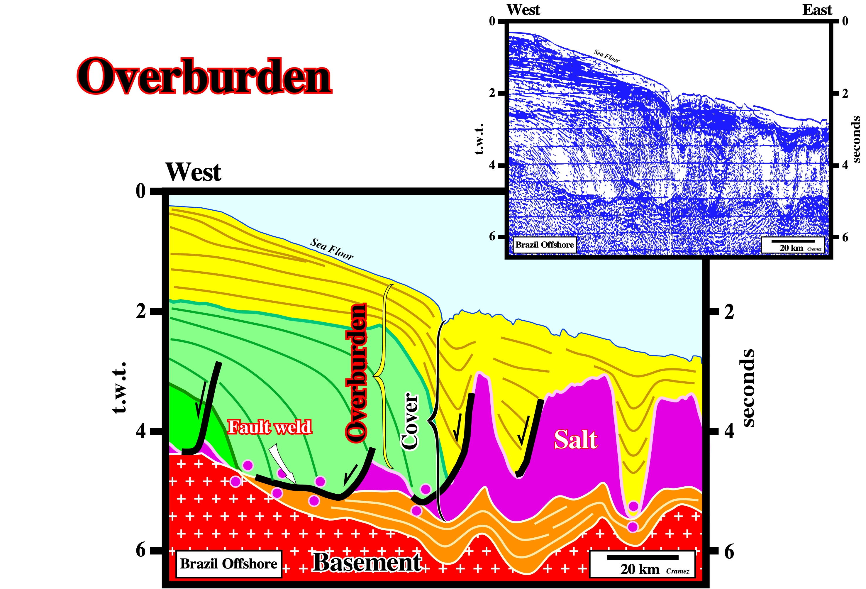
Overburden
Strata younger than the salt substratum or source layer.
On this tentative interpretation of a Canvas autotrace of a Brazil offshore seismic line, assuming the salt layer is autochthonous, what is the more likely (above basement), the sediments overlying it form the overburden.
Overhang
Part of the mass of a salt dome that projects out from the top of the dome much like the cap of a mushroom diapir.
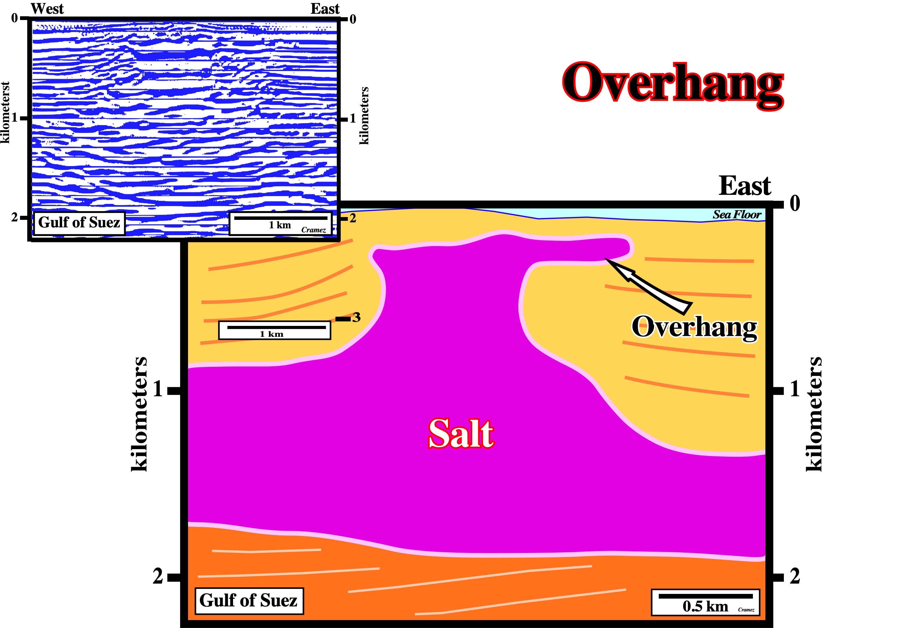
The overhanging periphery of salt bulbs are characteristics of a post-dome salt stage. At the sea bottom, the positive topographic anomaly, well developed Canvas autotrace of a Gulf of Suez seismic line, emphasizes the upward salt flowage, which contrasts with the lateral movement that creates the overhang.
Overturning
Exchange in position of the source layer and overburden such that the less-dense layer is eventually uppermost.
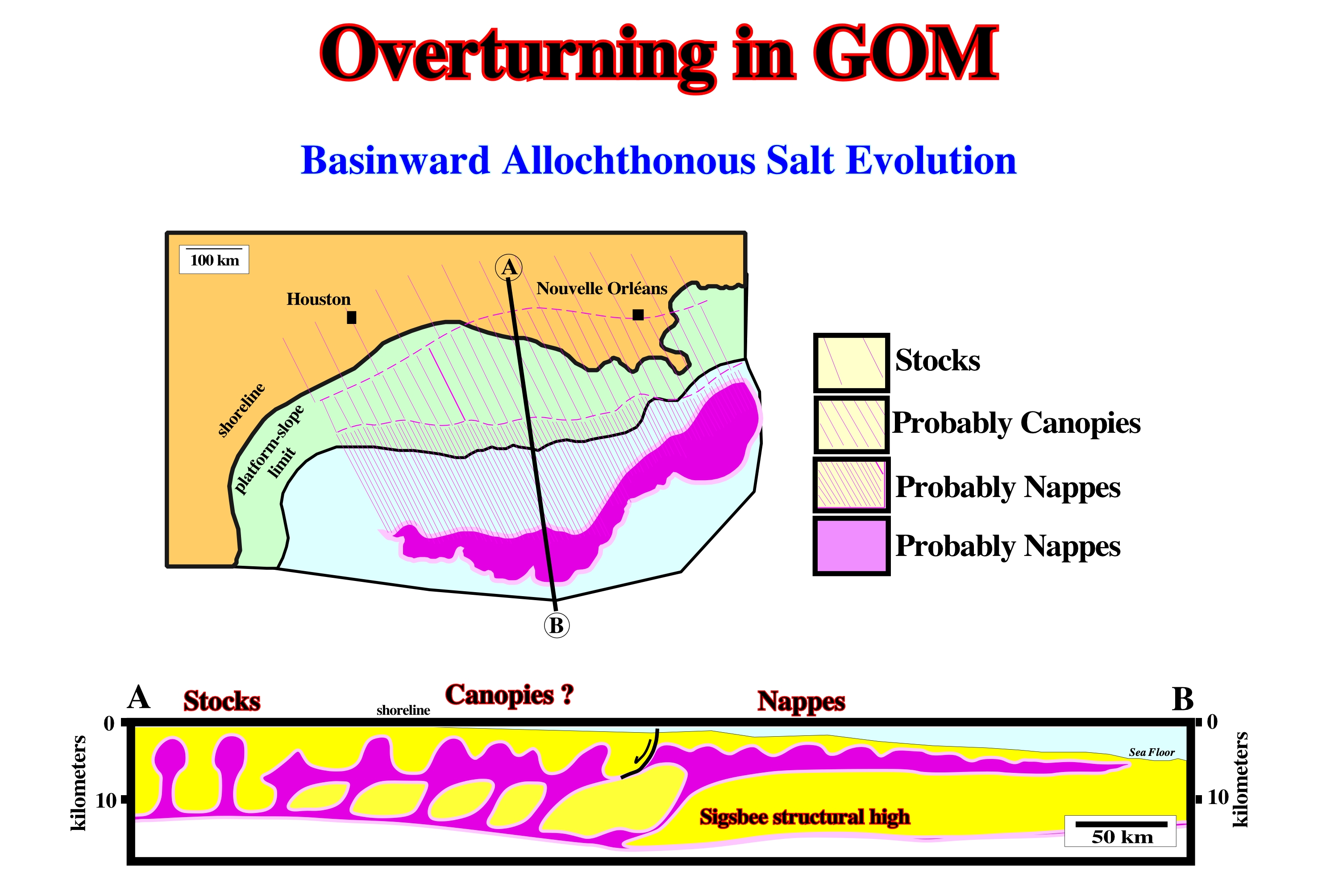
In Gulf Coast, the allochthonous salt napes are examples of overturning. As illustrated, the Louan salt, which age is Jurassic, is quite often intercalated in Miocene sediments.