
B-Type Subduction Zone
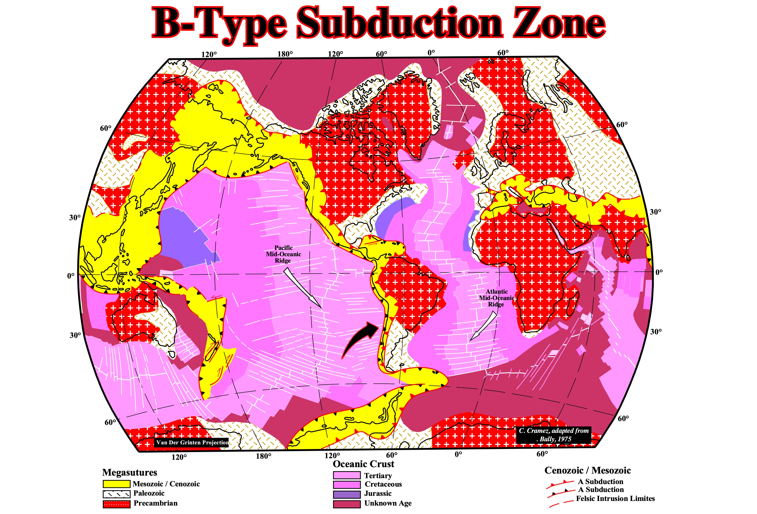
The age symmetry of the oceanic crust of each side of the Atlantic mid-oceanic ridge, which separates two divergent continental margin, strongly, contrast with the asymmetry of the Pacific mid-oceanic ridge, which separates two continental convergent margins characterized by a B-type subduction zones with quite different subduction rates. Eastward of the Pacific mid-oceanic ridge, the Jurassic and Cretaceous oceanic crusts are absent. They plunged under the South America lithospheric plate (overriding plate) at a higher speed than the western Pacific-mid oceanic ridge under the Mesozoic Cenozoic Megasuture.
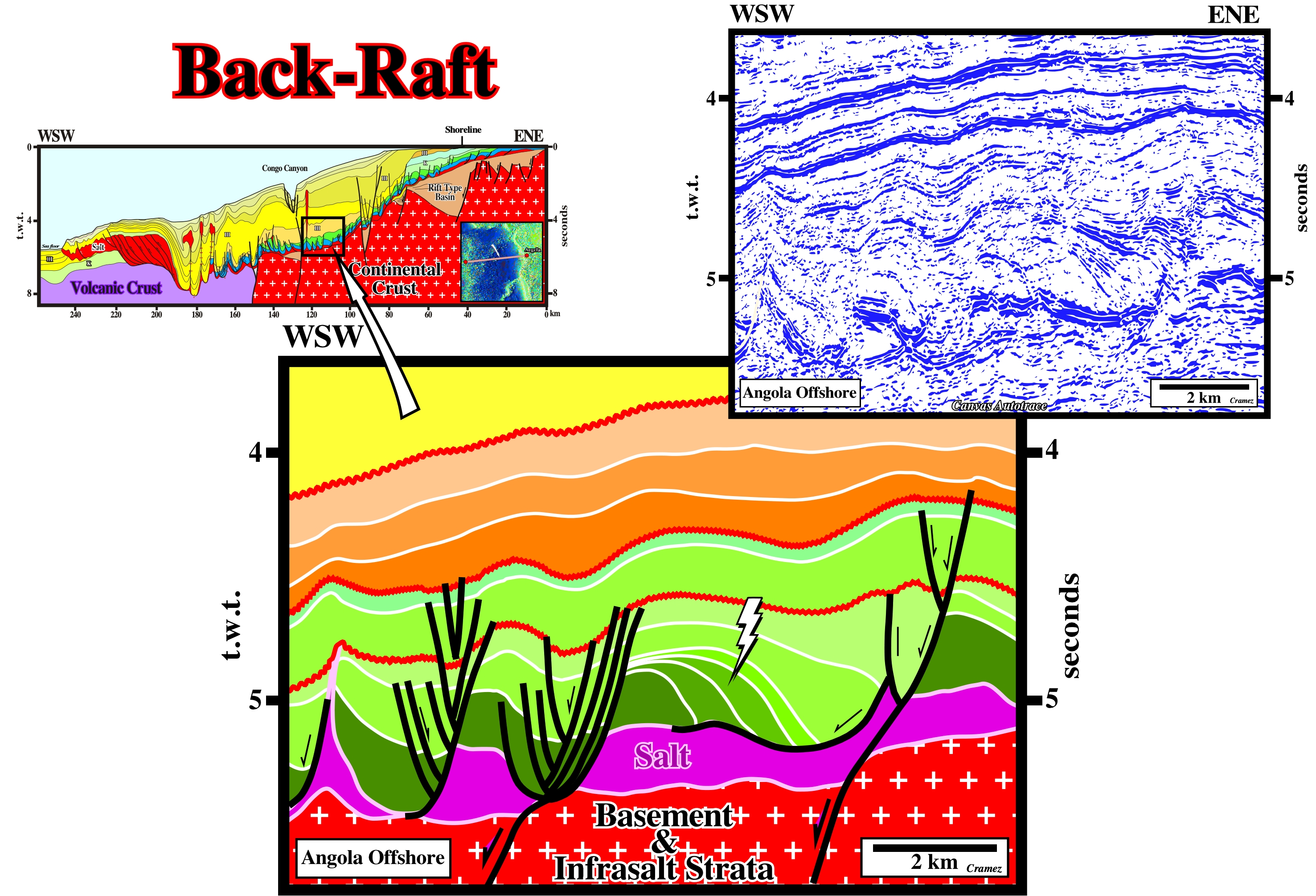
Back-Raft (Denelle, E.,, 1992)
Salt structure associated with rafts deposited above the downward fault compartment (hangingwall) of the major faulted blocks, when the basement is involved in deformation.
On this tentative geological interpretation of a Canvas autotrace of an Angola offshore seismic line, the basement is involved in the deformation (formation of rift-type basin, as illustrated on the geological interpretation of a Canvas autotrace of a regional composite seismic line). The normal faulting affecting the infrasalt sediments, which correspond whether to margin, rift-type basin fillings, Paleozoic sediments or even basement, creates asymmetric anomalies on the salt layer (salt steps) favouring the seaward displacement of the lower suprasalt sediments. The majority of the tectonic structures correspond to antiforms (extensional structures) induced by seaward salt flowage. The tectonic disharmony at the bottom of the salt is quite sharp. The infrasalt sediments are sligthly deformed compared with the overburden.
Backstepping (Mitchum et al., 1977)
A landward displacement of the depositional coastal break of the deposition surface within the transgressive interval (transgressive systems tract of certain geoscientist) of a sequence-cycle, as relative sea level rise. It is a synonym retrogradation. A backstepping is a consequence of increasingly smaller regressive intervals (progradational intervals) deposited in association with increasingly important marine ingressions. Backstepping takes place every time the depositional coastal break of progradational unit does not reach the depositional coastal break of the previous unit. A backstepping suggest a quite fast relative sea level rise. The sequence-paracycles are deposited during the stability periods of the relative sea level between the eustatic paracycles (increments of the relative sea level rise). During a marine ingression there is ravinement rather than deposition.
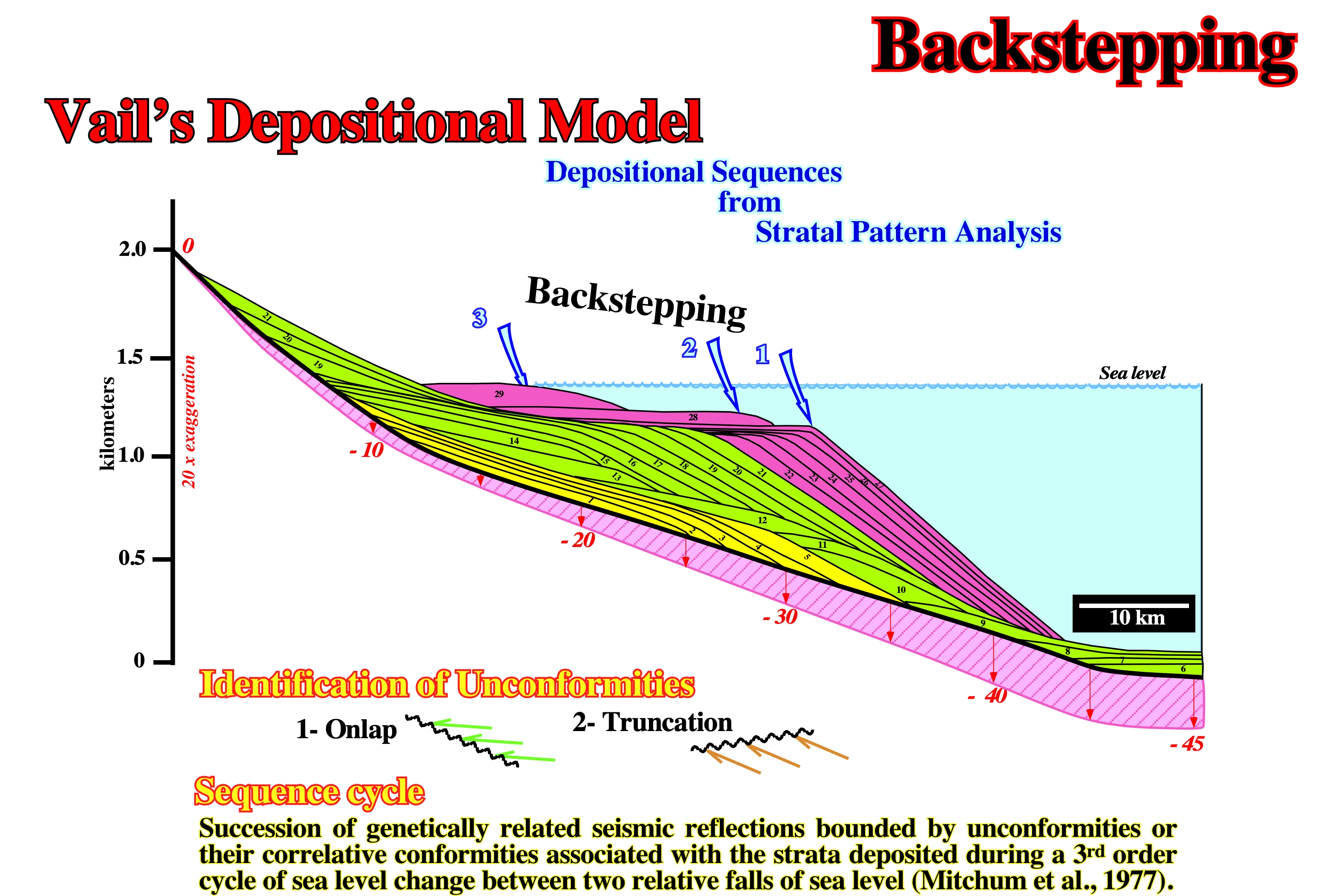
On this depositional model, in which three sequence-cycles are represented, two backsteppings are, easily, recognized. The first one, within the green sequence-cycle, between units 11, 12, 13 and 14, and the second one, within the violet sequence-cycle, between units 27, 28 and 28. The retrogradational or backstepping intervals are associated with transgressive intervals (increasing smaller sedimentary regressions) induced by significant relative sea level rises (increasingly important marine ingressions). A backstepping not only increases the area of the shelf, but the depositional water-depth as well.
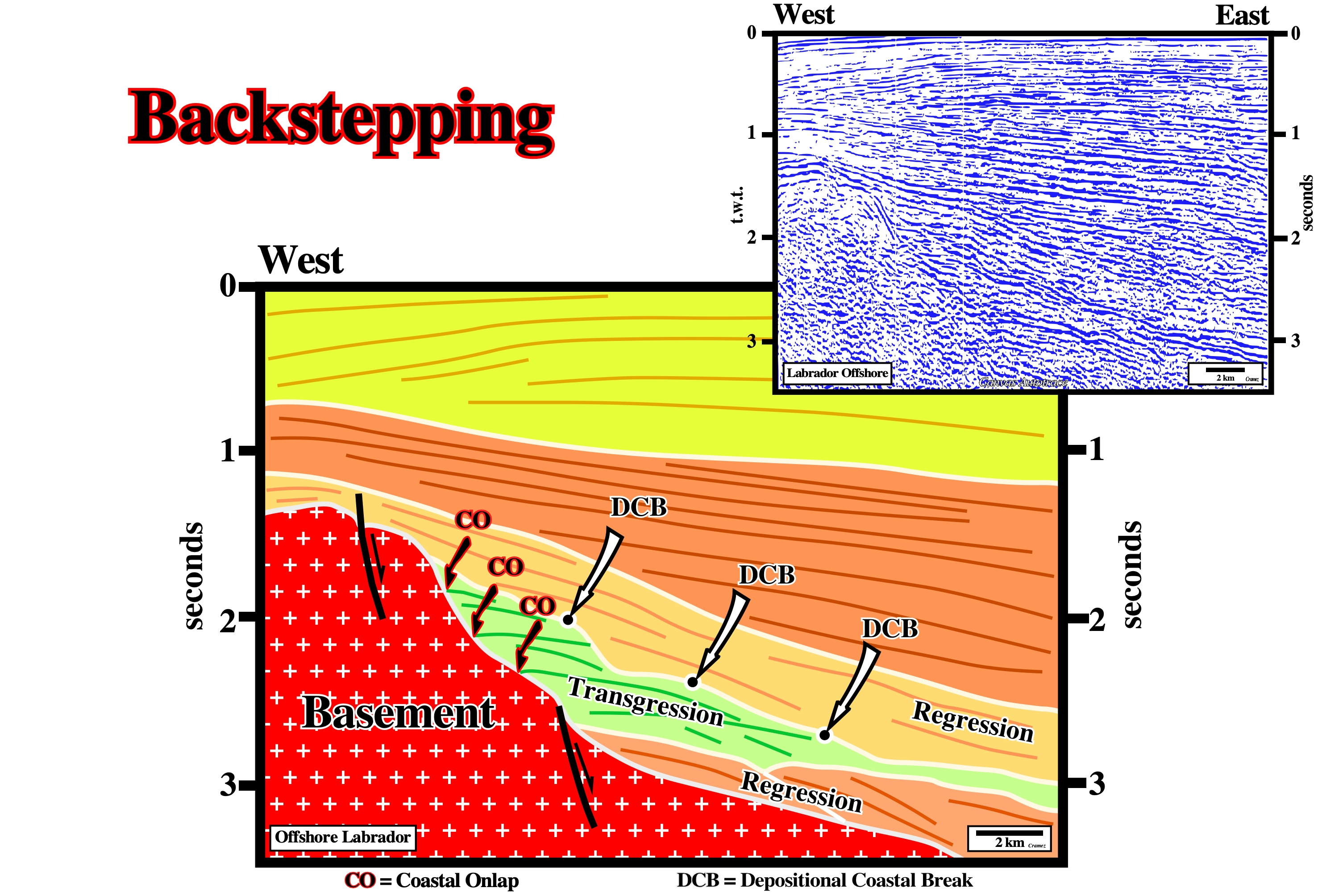
Two completely different geometries and internal configurations are recognized on this tentative interpretation of a Canvas autotrace of a Labrador offshore seismic line. The regressive interval has a progradational geometry, while the transgressive interval has a retrogradational (backstepping) geometry. Within the progradational interval, the successive depositional coastal breaks (DCB) are displaced seaward and the thicknesses of the intervals increase basinward before disappear by condensation (downlapping). Contrariwise, within backstepping interval, the depositional coastal breaks are, progressively, displaced landward (increasing smaller sedimentary regressions) and the thickness of deposited intervals increase landward, before disappear by onlapping. The aggradation, given by the coastal onlaps, is positive in transgressive intervals and, generally, negative in regressive intervals. At a sequence-cycle hierarchic level, a sedimentary transgression is just a succession of smaller and smaller sedimentary regressions. It is important do not forget that to have deposition (turbidite systems excluded), the relative sea level must rise (increasing accommodation). If the relative sea level rise in acceleration a retrogradational unit is deposited. If the relative sea level rise in deceleration a progradational unit is deposited.
Backward Molding Model (Talbot, 1995)
See Molding Model
Molding model starting by inferring histories of molding ratios, from profiles of individual diapirs, and then, by comparing the molding histories of suites of diapirs. In backward molding models, the selection process is started with the full model and variables are excluded sequentially. In forward molding models, the selection process start with an empty model and variables are added sequentially. Forward models of molding ratios that vary in both space and time hint at the potential of reading molding histories from dip of salt molded during particular intervals of space in time.
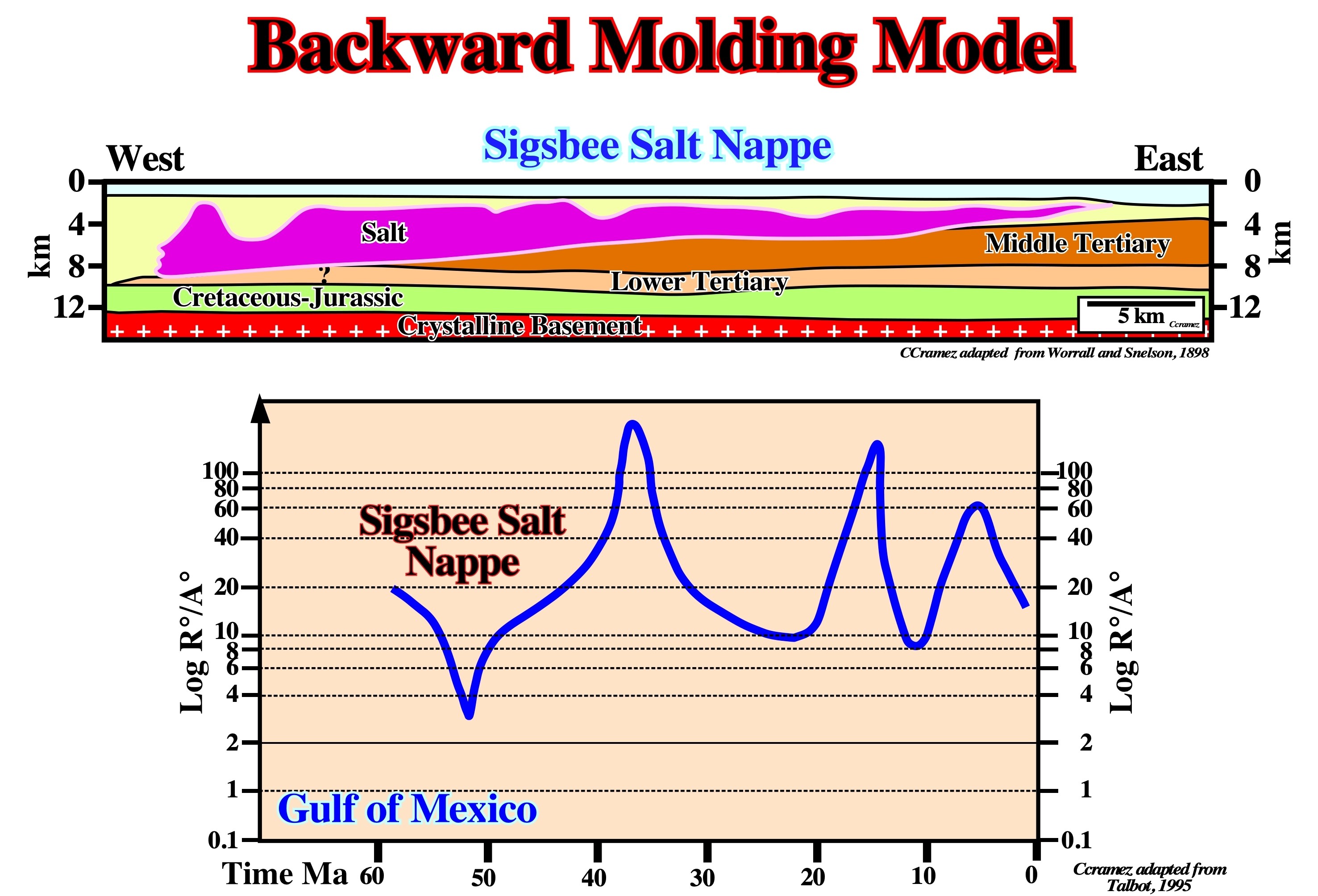
The blue curve represents the backward models of the history of the molding ratio for most of the Tertiary from the flared bottom of the Sigsbee salt nappe in Gulf of Mexico illustrated in the above geological cross-section. The Louan salt is, usually, considered to be driven by the overburden advancing by sedimentary progradation and gravity spreading. The bottom contact of the Sigsbee nappe ramped as steeply as 11°-14° in the Eocene, suggesting the salt then slowed at ± 52 Ma to spread just 4-5 time faster down-slope than the local clastic sediments aggraded. However, even then, the lowest molding ratio for the nappe remained in the flaring regime. Since ± 56 Ma, the molding ratio of the most distal salt nappe, rarely, fell below R°/A° ±10. The increase in structural relief of a diapir (R) occurs at the net rate, R°, which is the rate of the vertical rise of the salt diapir minus any salt dissolution. The local net accumulation of the overburden thickness (A) occurs at rate A° (rate of aggradation of the overburden minus its vertical compaction).
Balanced Cross-Section
A geological profile constructed on the basis of field observation and/or seismic and borehole data, in which volume problems (Goguel's law) are respected (a cross-section geometrically possible). Palinspathic sections are required to test balanced cross-sections. If a palinspathic section falsify the proposed balanced section another must be proposed, and so far. In salt basins, balanced cross-sections are difficult to propose. As the salt can flow in any direction, Goguel's law is not adequate to test whether the cross-section is balanced or not. Geologists used palinspathic sections to estimate the displacement or orogenic contraction resulting from thrusting and associated imbrication and folding, as illustrated below.
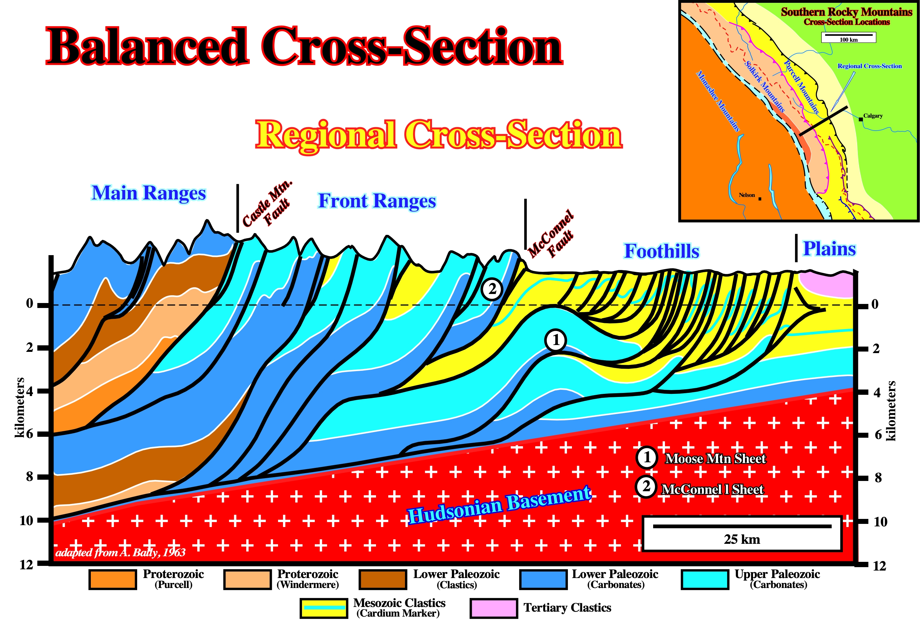
This geological cross-section, proposed by A. Bally, in 1966, is balanced (see figure below). The Paleozoic carbonate skeleton consists of a several thrust sheets. Overlying the Paleozoic carbonates there is an envelope of complex Mesozoic imbrications. Most should be considered as being sheared off the top of the lower sheet by the higher Moose Mountain sheet. Actually, the thrust displacement of the Cardium formation, for instance, often, exceeds the slip shown for the underlying frontal sheets. This implies the Moose Mountain sheet sheared off Mesozoic beds off their carbonate substratum before the more easterly lower thrust sheet was formed.
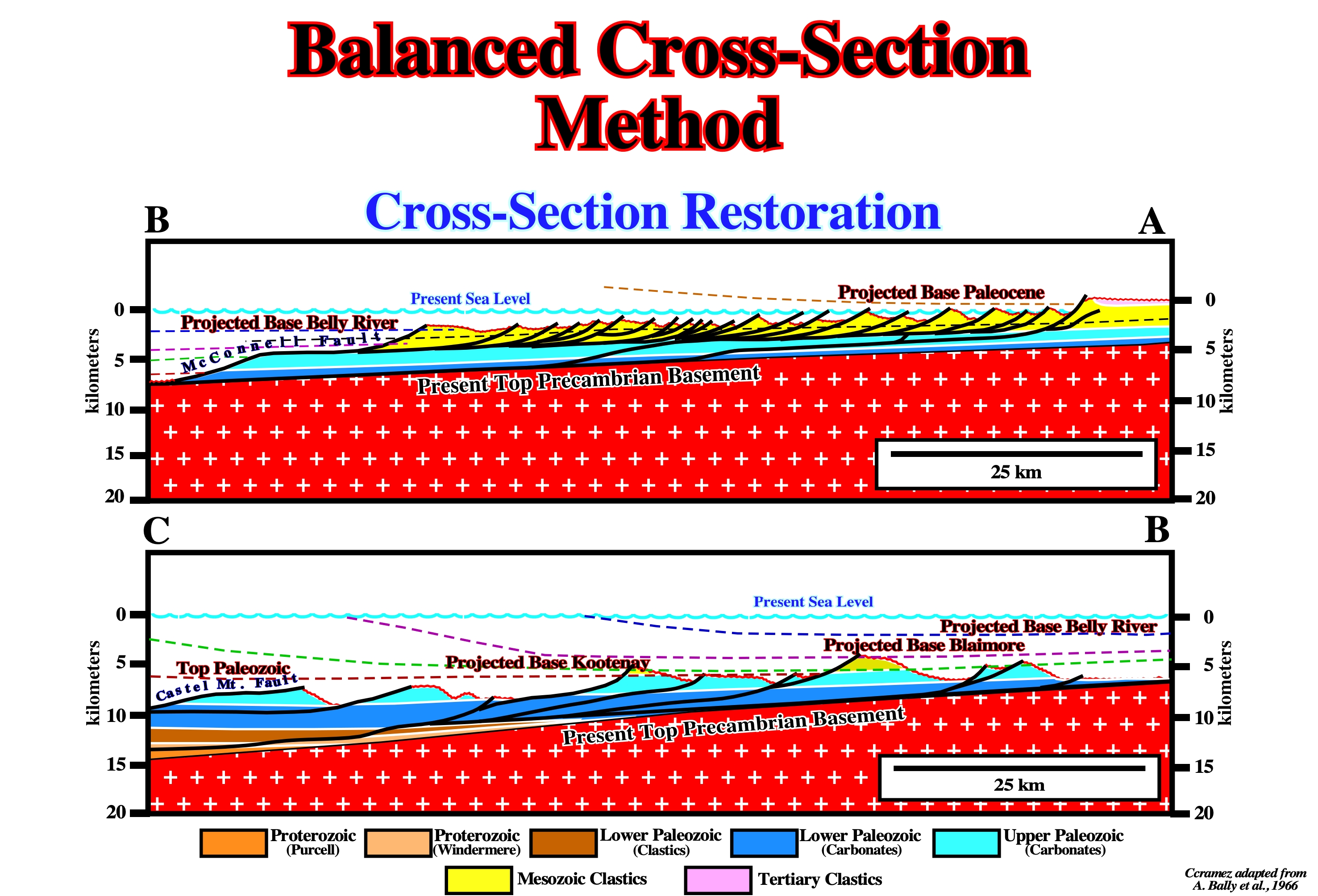
Here, each imbrication and thrust sheet is shown in its present and restored position. Offsets in the line of the section are disregarded and, for ease of construction, the restoration is tied to the present basement gradient, whereas to the west a non specific datum is assumed. Nowhere in the structure section or in its restoration the Paleozoic section is, completely, missing. A. Bally (1966) assumed no major structural units have been removed by erosion. He calculated a shortening in the order of 50%, or about 160 km for the Main Ranges.
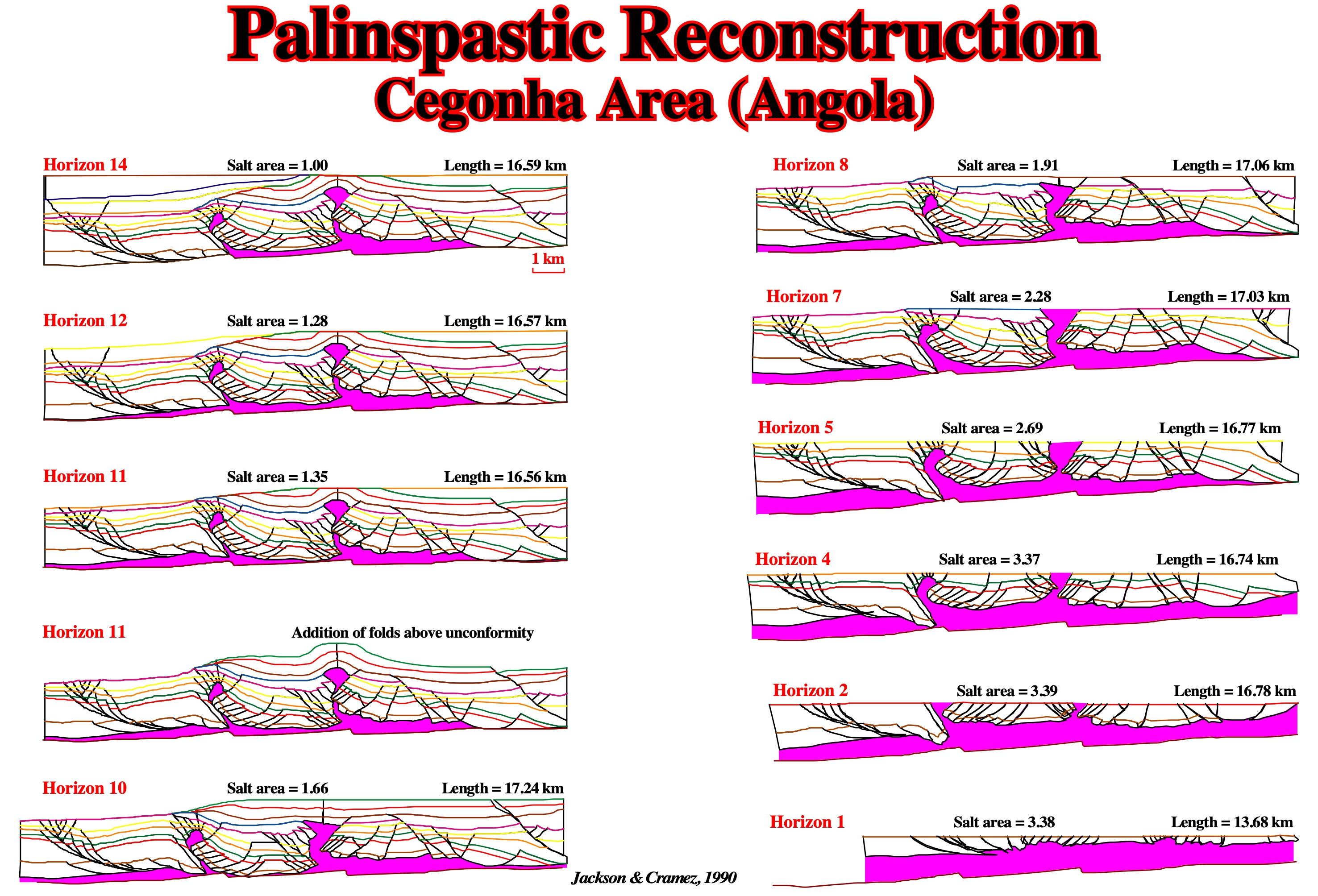
The palinspathic restoration of the Cegonha salt induced structure (Angola conventional offshore), made with Restore software, suggests the tentative interpretation of Canvas autotrace of the seismic line through Cegonha is likely (see Anticline Salt). The palinspathic restoration does not falsify the seismic interpretation, however, it does not prove that the tentative geological interpretation is right. It just says it is, geometrically, possible and the volume problems were respected. A solution is not, necessarily, unique. For many given data set, there are, generally, several possible solutions.
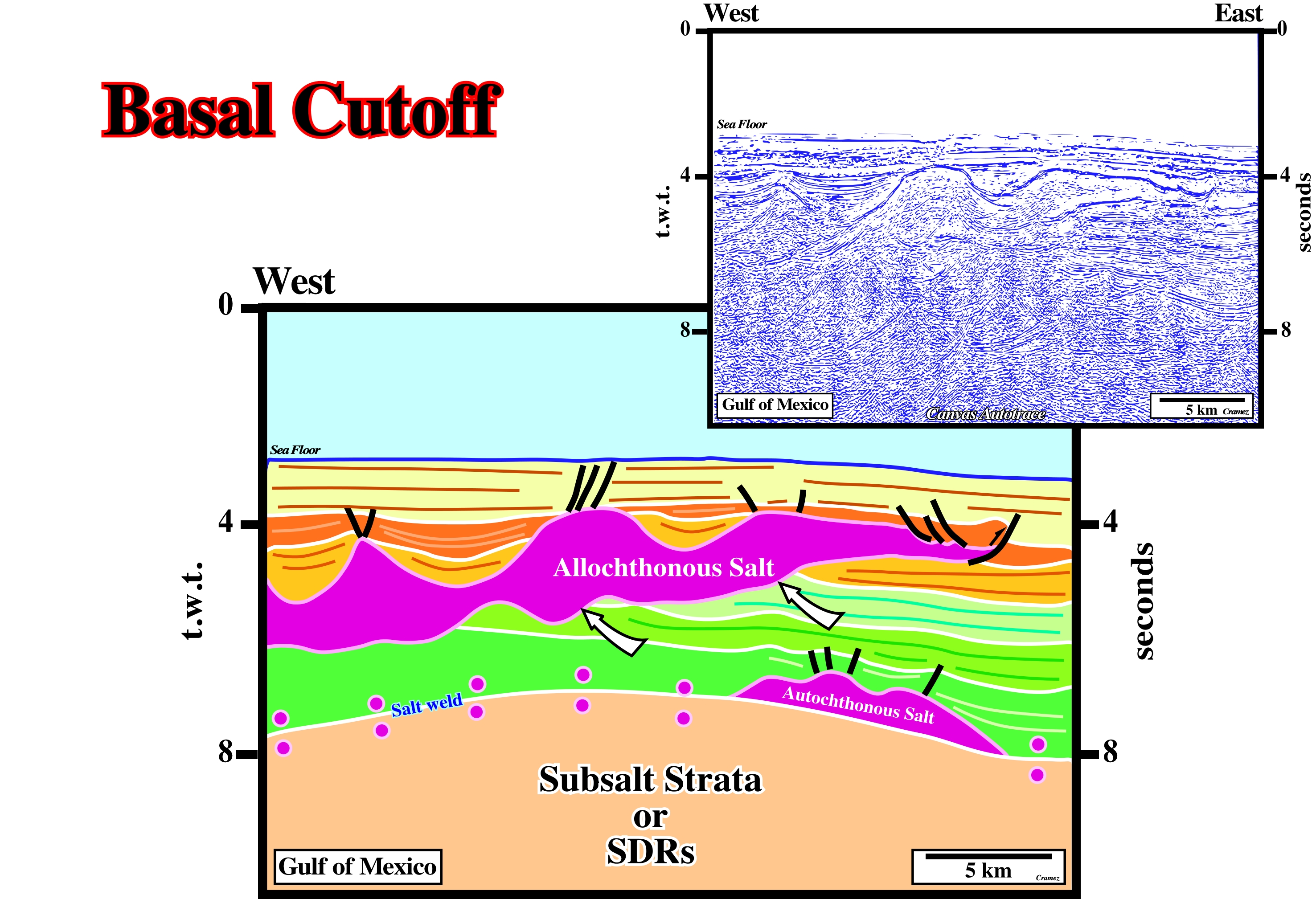
Basal Cutoff
An oblique truncation of strata against the lower contact of a salt tongue. Each cutoff marks successive positions of the leading edges of a spreading tongue at successive stratigraphic times.
On this tentative geological interpretation of a Canvas autotrace of a Gulf of Mexico seismic line, a relic of autochthonous salt is visible at around 8 seconds depth (t.w.t.), as well as, an important salt weld, which underlines a tectonic disharmony between the cover (salt + overburden) and the infrasalt or subsalt strata. The more or less vertical salt steps (basal cutoffs), visible along on the bottom of the allochthonous salt, represent periods of time during which the salt layer moved upward to an upper stratigraphic level.
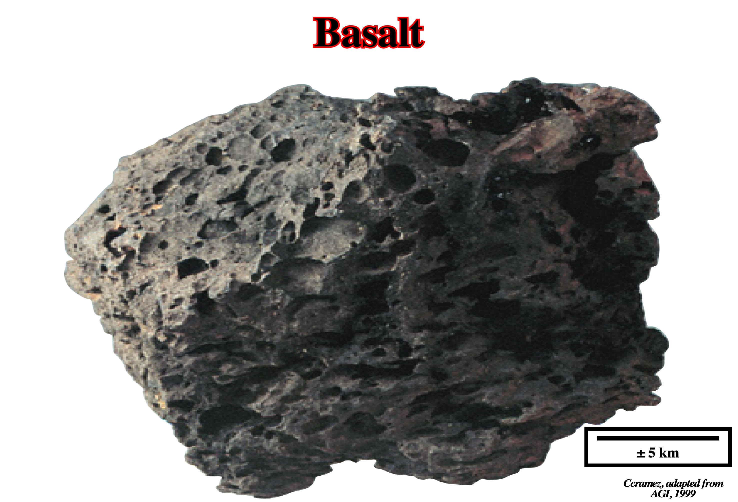
Basalt (SDRs) (American Geological Institute, 1999)
A general term for a dark-colored mafic igneous rock, commonly, extrusive but, locally, intrusive (e.g., as dykes), composed, chiefly, by calcite, plagioclase and clinopyroxene. It is the fine-grained equivalent of the gabbro.
Basalt and particularly, subaerial lava flows, altered, hydrothermally, into spilite greenstones, are at the origin of MgSO4 poor potash evaporites. Chloritization absorbs Mg from the brine. Albitization releases abundant Ca into the brine, which combines with any SO4 present to precipitate at surface and the brine lakes remain enriched in Ca. The brines of Louan salt, in Gulf Coast and Loeme salt, in West Africa, were, strongly, enriched in Ca by the subaerial volcanism (SDRs) emplaced since the breakup of the lithosphere. Both salts have similar composition to the salt deposited in association with the volcanism emplaced in the Gulf of Aden triple point (Aden ridge - East Africa rift axis - Ertaiale Red Sea rift axis), particularly, in the Assal lake (see below).
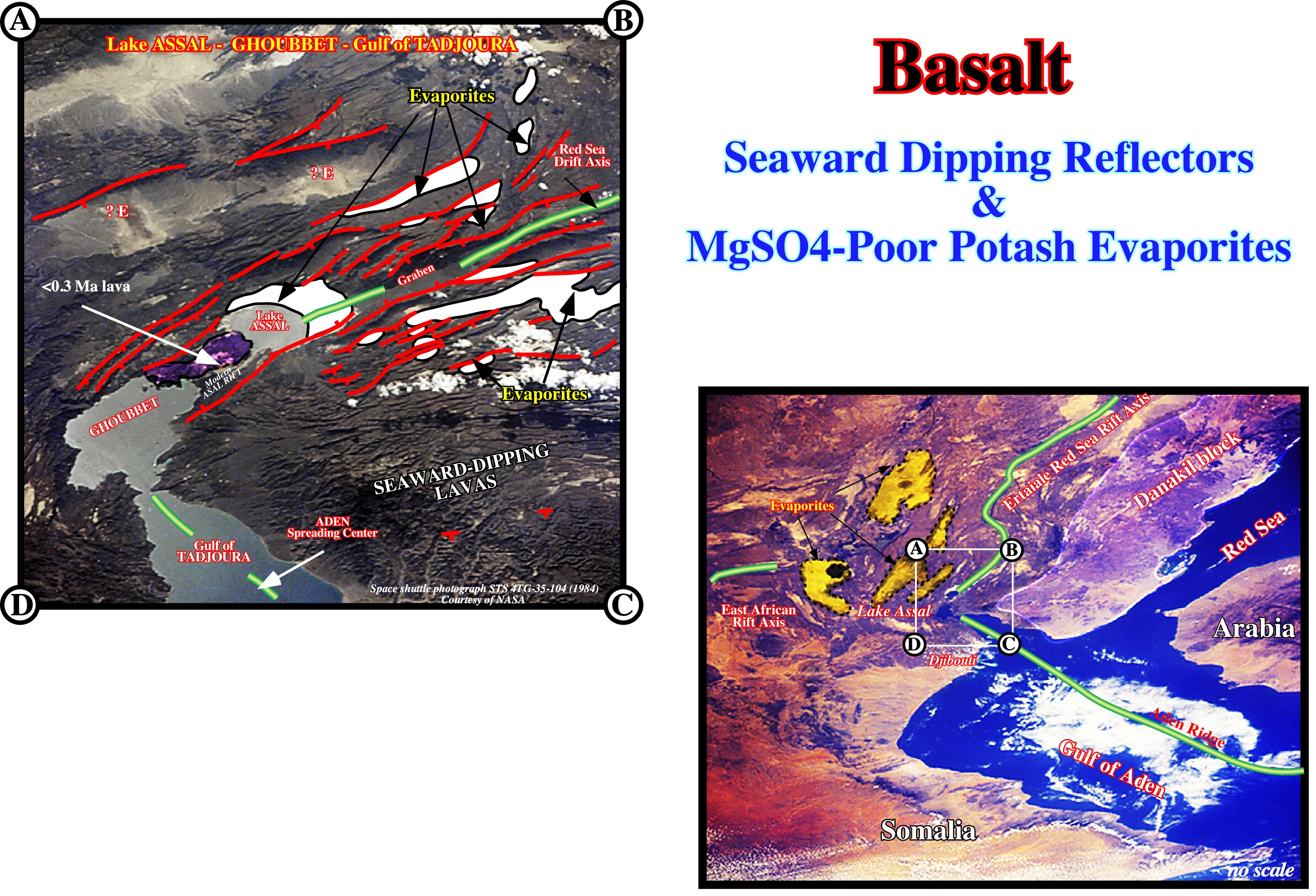
After the breakup of the lithosphere, as a new continental divergent margin becomes submerged, restricted circulation of seawater can allow evaporites to accumulate, directly, on flood basalts as it is the case Afar area. Seawater can, periodically, spill in behind topographic dams and evaporate, subaerially, to form salt below sea level. These evaporites, with KCl minerals originate from brines enriched in CaCl2 by hydrothermal water-basalt interaction, form part of the post-rift package, whose accommodation space is provided by crustal thinning, cooling, magma withdrawal, and pilling up of SDR wedges on margins. The Afar region (Djibouti, Horn of Africa), where the Ethiopian plume, the Red Sea rift, and the Aden spreading ridge all meet subaerially, evaporites (colored in white), accumulate, subaerially, below sea level above proto-ocean dark basaltic crust. The evaporites are prominent around Lake Assal but also occur in halfgrabens. Lake Assal is the deepest point in Africa, 168 meters below sea level. The lake occupies the eastern end of the Assal rift behind a barrier of lava (less than 0.3 My old), which prevents the shores of Lake Assal from being submerged. The volcanic barrier separates Lake Assal from the Ghoubbet and Gulf of Tadjoura, which contains the obliquely prograding, left-stepping Aden spreading axis. Shadowed fault scarps yield, mainly, left-lateral fault-plane solutions.
Basement
Undifferentiated complex rocks underlying the rocks of interest in a given area. In salt tectonics, below the autochthonous salt, an infrastructure or subsalt strata is, often recognized, above, the basement. In petroleum geology, the basement is, often, formed by rocks without generating petroleum potential. In many places, the rocks of the basement are igneous and metamorphic of Precambrian age but, in other places, they can have a Paleozoic, Mesozoic or Cenozoic age.
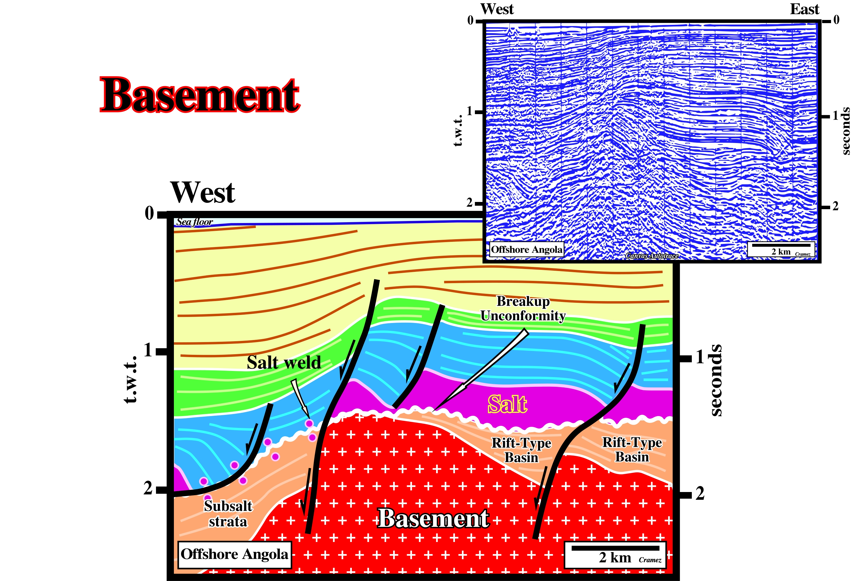
On this tentative geological interpretation of a Canvas autotrace of a seismic line shot in northern Angola offshore (Cabinda), the basement, mainly composed by Paleozoic sediments and locally granite-gneiss, is, clearly, involved in deformation. At least two faults affect the cover (salt + overburden), infrasalt or subsalt sediments and the basement (Paleozoic fold-belt). These faults are, more or less, sub-vertical. They contrast with listric and curvilinear faults the cover, which flatten on the top of the salt layer or on a salt weld. The infrasalt sediments seem to infilling rift-type basins, which developed before the breakup of the Pangea supercontinent, i.e, they were located below the breakup unconformity. In this area, the thickness of the margin basal sandstones (Chela formation), located below the salt and above the breakup unconformity, is, generally, under the seismic resolution.
Basement Faulting
Faults affecting the basement. In salt basins, they can predate the salt or postdate it. In both case, they have important implications. They can induce the emplacement of salt anomalies and tectonic inversions, as illustrated on the figures below.
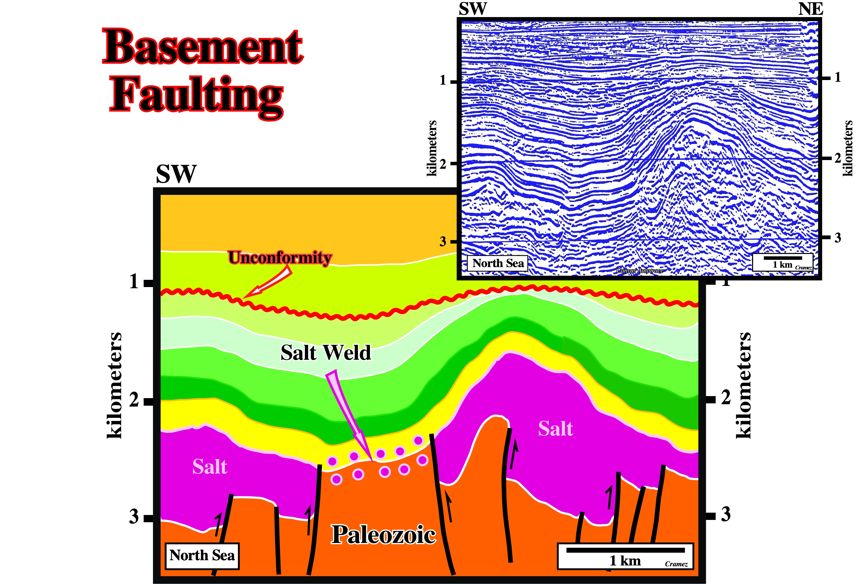
On this example, the faults affecting the basement (Paleozoic sediments) are posterior to the salt (Zechstein). They were created by a post-salt extensional tectonic regime, which took place in Cretaceous time (second green interval). During the extension the salt flowed laterally and downward filling, in the basement, the space created by the normal faults (grabens). A later compressional tectonic regime reactivated the original normal faults as reverse. Such reactivation created obvious tectonic inversions, in which the Cretaceous salt grabens, created during the extensional tectonic regime, became anticline structures.
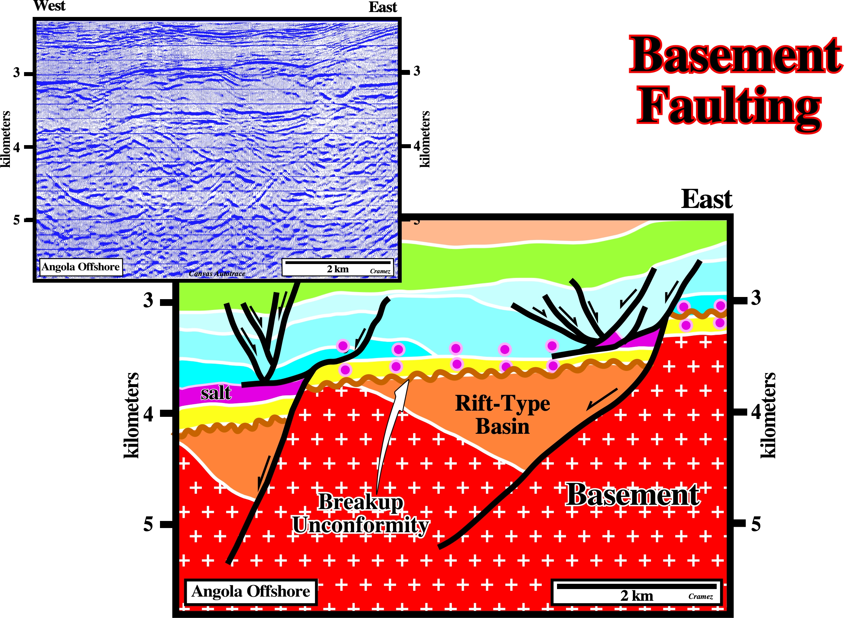
On this example, the faults, affecting the basement (granite-gneiss), predate the salt deposition. They were created during the rifting phase before the breakup of the Gondwana lithosphere. After the breakup, they were slightly reactivated. The margin presalt strata, colored in yellow, is faulted. This reactivation created small steps (called basement steps) that were, probably, fossilized during the salt deposition by onlapping of the salt layer. The tectonic reactivation affected already deposited the salt pods creating salt anomalies (the salt layer is, generally, the agglutination of multitudinous salt pods), above which mounds or domes can afterwards be formed (see geological model below). Later, the basinward salt flowage and salt withdrawal induced the formation of back-raft structures, which are recognized at present time on seismic lines.
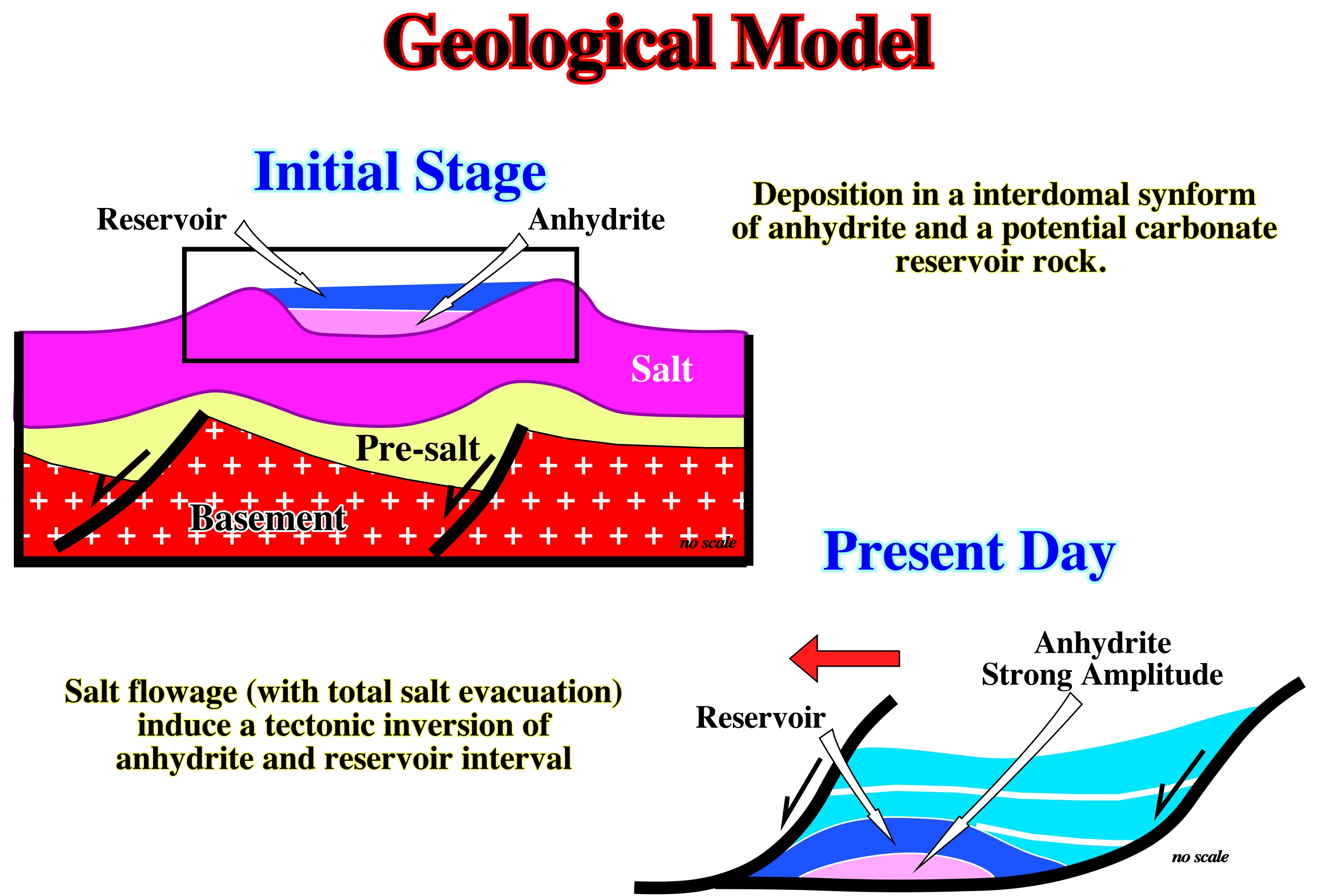
This geological model, proposed by Total's geologists, is one of the possible explanations for the formation of the Pinda back-raft structures, in Angola offshore. There is a obvious connection between basement highs and pristine salt mounds or salt diapirs, which, later, by salt flowage induced back-raft and fore-raft structures. Later, due to a seaward displacement of the cover (salt + overburden), back-raft and fore-raft structures were, slightly, displaced down-dip of the buried hills (highs of the basement).
Basement Step
Fault throws affecting the infrasalt sediments. In salt tectonics, basement steps are in fact subsalt strata steps, which, often, are created by major fracture zones associated with sea floor spreading or by rifting faults (faults bordering rift-type basins). During the seaward translation of the cover, the presence of such a fault steps, creates translation onlap surfaces (see below).
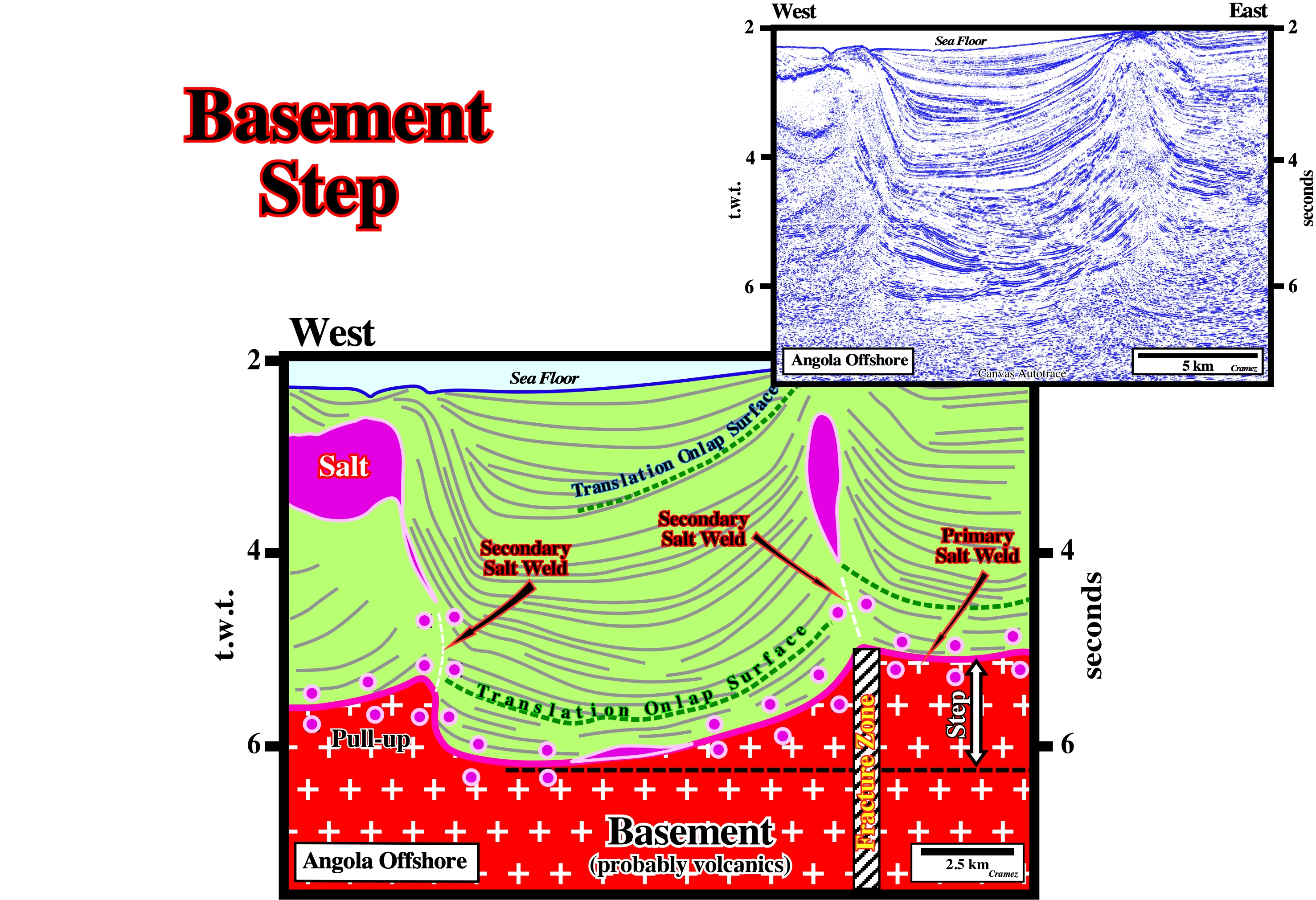
A sub-salt strata step is, easily, recognized picking of the bottom of the autochthonous salt, which, on this Canvas autotrace of an Angola offshore seismic line, is almost, exclusively represented by a salt weld. Such a step, probably, created by a major fracture zone, striking, roughly, perpendicularly to the seismic line, has a height of 1.2 seconds (t.w.t.). Due to the seaward translation of the cover, two translation onlap surfaces were created, which are, easily, identified by their apparent geometrical relationships (apparent downlaps with a landward vergence).
Bedding Plane (McNeill, L. et al., 1999)
A plane of deposition. It marks, often, a change in the circumstances of deposition and may show a parting, a color difference, or both. This term is, often, applied to any bedding surface even when, conspicuously, bent or deformed by folding.
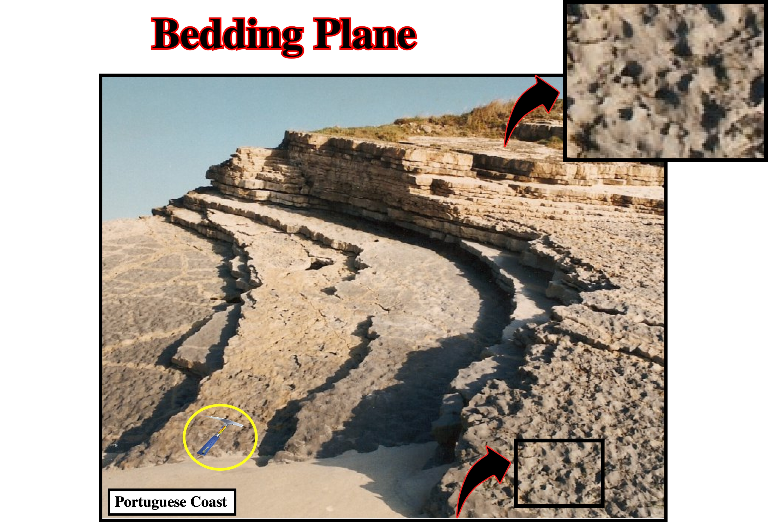
A stratigraphic surface can be considered as a continuous physical boundary. At least three major groups of stratigraphic surfaces can be observed in the field or on seismic data (in favorable conditions): a) Stratal Surfaces ; b) Discontinuity Surfaces and c) Diachronous Surfaces. Bedding planes and chronostratigraphic seismic reflectors are stratal surfaces (a seismic reflector represents a, more or less, thick sedimentary interval, which thickness depends on seismic resolution: it can ranges between 10 and 100 meters). Stratal surfaces, typically, represent a, relatively, small time-gap. If the time-gap (hiatus) is large, the surface is called unconformity. The term large is relative. It depends on the time scale considered. The term unconformity is, mainly, used when the time-gap corresponds to an erosional hiatus (relative sea level fall). A time-gap associated to a non-depositional hiatus is often termed disconformity. Stratal surfaces may represent different amounts of time from place to place, i.e., the hiatus changes laterally. Stratal surfaces represent at least some small unit of time common to the surface over its entire extent. The concept of stratal surfaces is, completely, dependent on the time scale and rock under consideration.
Benioff Subduction Zone
Zone between two lithospheric tectonic plates, in which the sinking plate is oceanic. Benioff subduction zones or B-type subductions, characterize convergent margins. They are zones of great seismicity. They are associated with deep-sea trenches and they dip toward and beneath volcanic arcs, along which earthquakes foci cluster.
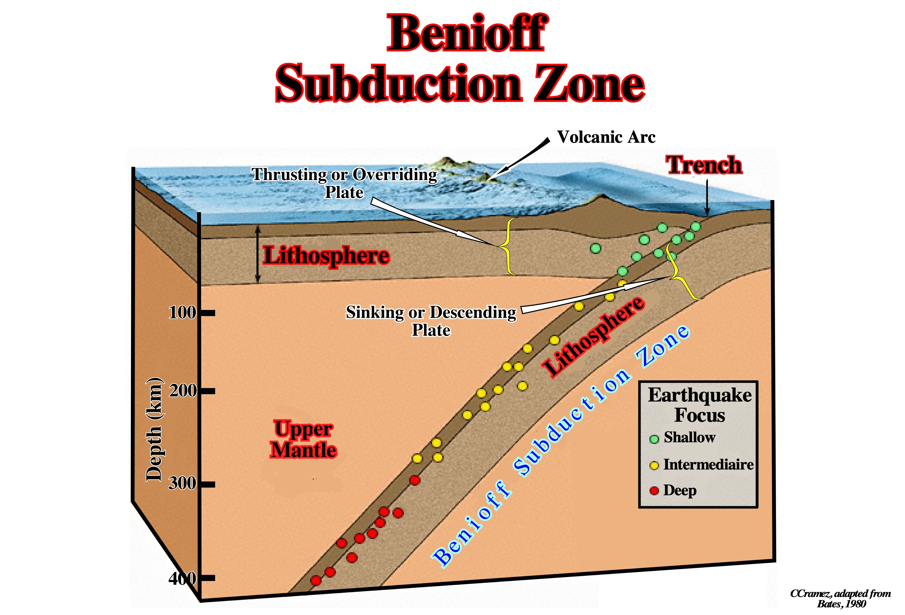
Depending on the lithology of the thrusting plate (sinking plate always oceanic) different types of convergent margins can be considered. The South America western margin (Andean margin) is a typical example of convergent margin, in which the thrusting plate is continental. As illustrated on this sketch, a volcanic arc, located on the thrusting plate, is always associated with a Benioff or B-type subduction zone.
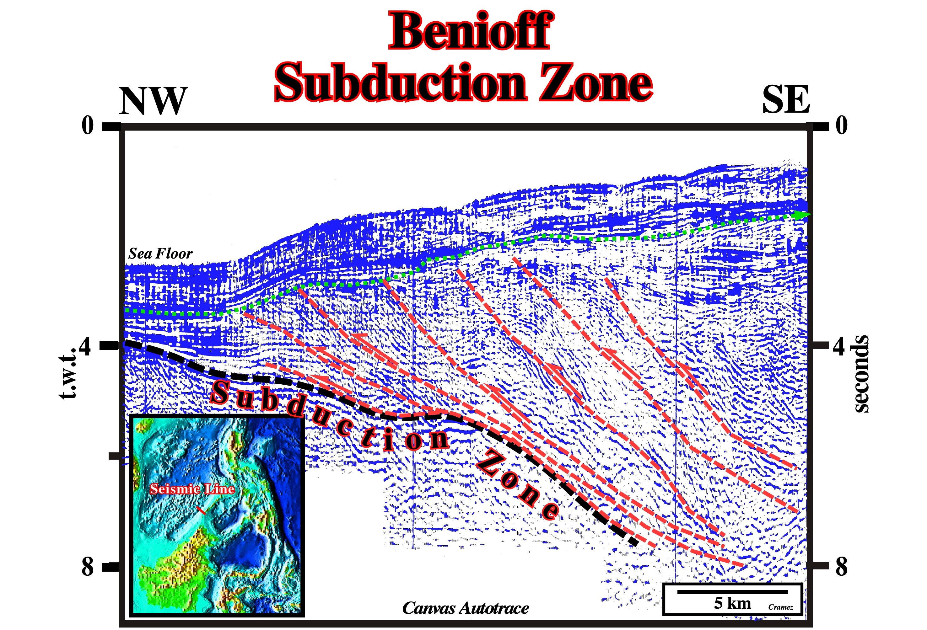
On this Canvas autotrace of a Palawan offshore (Philippines) seismic line, the sinking of the oceanic plate induced a significant shortening in the thrusting plate obliging the sediments to accommodate to new volume conditions creating an accretionary prism, which, in this particular example, is characterized by a great number of thrust faults. The shortening of the overriding lithospheric plate seems in sequence (the younger thrust faults are those near the trench). The sea floor on the thrusting plate is quite deformed. Similar salt accretionary prisms, induced by local shortening (counterpart of up-dip extension), are recognized in deep South Atlantic offshores as it is the case in Angola Offshore.
Bentonite (Bates, R. L. and Jackson, J. A., 1980)
A soft, plastic, porous, light-colored rock composed essentially of clay minerals of the montmorrillonite (smectite) group plus colloidal silica, and produced by devitrification and accompanying chemical alteration of a glassy igneous material, usually, a tuff or volcanic ash. It contains, often, accessory crystal grains that were, originally, phenocrysts in the parent rock. Its color ranges from white to light green and light blue when fresh, becoming light cream on exposure and changing, gradually, to yellow, red, or brown. The rock is greasy and soap-like to the touch and has, commonly, the ability to absorb large quantities of water accompanied by an increase in volume about 8 times.
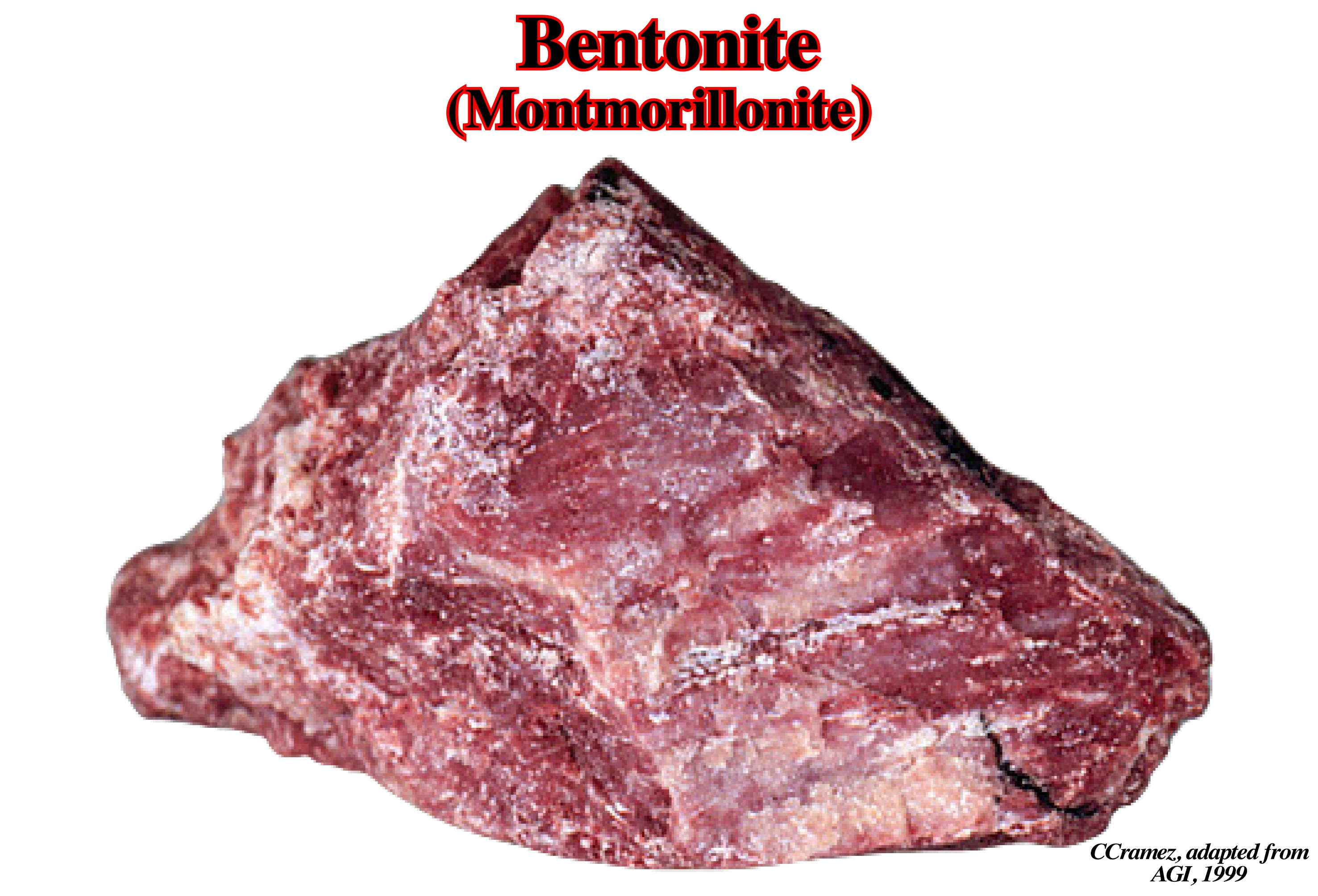
There are two types of bentonite: (i) Sodium bentonite, which increases in volume when wet and can absorb several times its mass in water (this property is highlighted in mastics, or for the burial of pollutants in the ground); it is used in oil drilling wells and geothermal research and (ii) Calcium-based bentonite (pascalite, found only in Big Horn Mountains of Wyoming at 8,600 feet and no where else known on Earth), which does not have swelling properties, but has a lot of para-pharmaceutical applications. Due to its rheological features, bentonite has a thixotropic behavior (becomes liquid when stirred or shaken). Small amounts of bentonite in aqueous solution form a viscous mixture, whose viscosity decreases when the mechanical stress applied to it increases (https://fr.wikipedia.org/ wiki/Bentonite). Montmorillonite is a member of the dioctahedral smectite group of minerals that has the origin of the layer charge primarily in the octahedral sheet. An ideal formula is: (Na,Ca)0.3(Al,Mg)2Si4O10(OH)2.
Biaxial Ellipsoid
Ellipsoid in which the two perpendicular horizontal axes are equal. At a given depth point, the geostatic pressure can be represented by a biaxial ellipsoid, with a vertical axis (σv) and two equal horizontal (σh). All axes of an ellipsoid are orthogonal normal stresses.
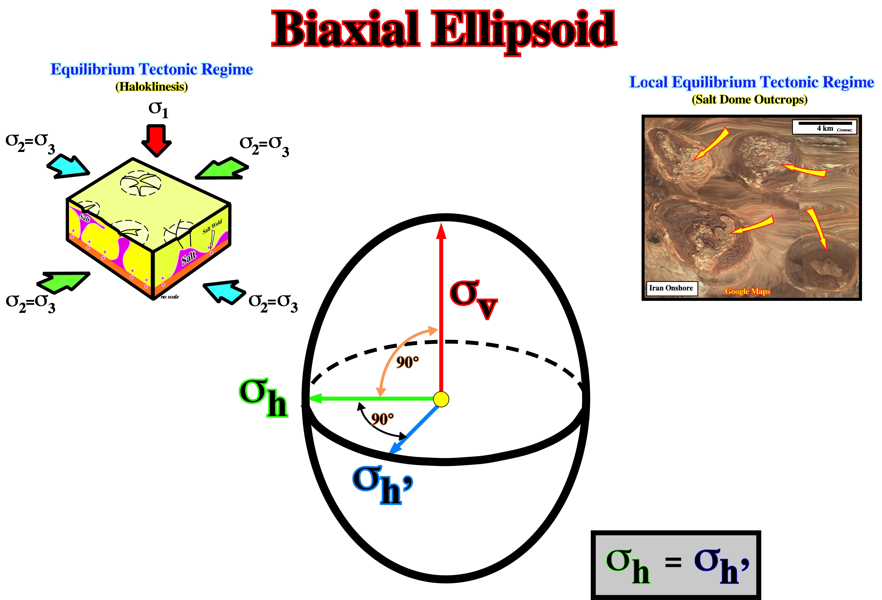
At a given depth, the geostatic stress (σg) is the stress caused by the weight of a column of the overlying beds. Generally, in the lithostatic (geostatic) pressure, the vertical stress is higher than the horizontal stress. In the upper levels of the continental crust, depending of the rheology of the sediments, the horizontal stress ranges between 5/10 to 8/10 of the vertical stress. In depth, a biaxial ellipsoid can become an uniaxial ellipsoid, i.e., the ellipsoid becomes a sphere: (i) Near the surface, rocks of a elastic behavior, therefore: σh< 1/3σv ; (ii) At medium depth, rocks of a viscous-elastic behavior, therefore: 1/3σh< σh and (iii) At great depth, rocks of a viscous behaviour, therefore: σh=σh . Salt some outcrops emphasize an local tectonic regime characterized by a biaxial ellipsoid (equilibrium regime with a null tectonic vector (σt=0).
Bischofite
Bischofite is a white or colorless hydrous magnesium chloride mineral with formula MgCl 2 6H 2O.

This mineral can be found as part of evaporite rocks of marine origin. It is the terminal crystallization point of the K-Mg-Na salt sequence. Among the many impurities that it has,,usually, it is commonly enriched in bromine, calcium and sulfur. It has been observed it is very common to appear as a secondary mineral formed from the alteration by the carnalite water (KMgCl3 6H2O).
Borate
A mineral compound characterized by a fundamental structure of (BO3)-3. An example of a borate is the boracite: Mg3B7O13
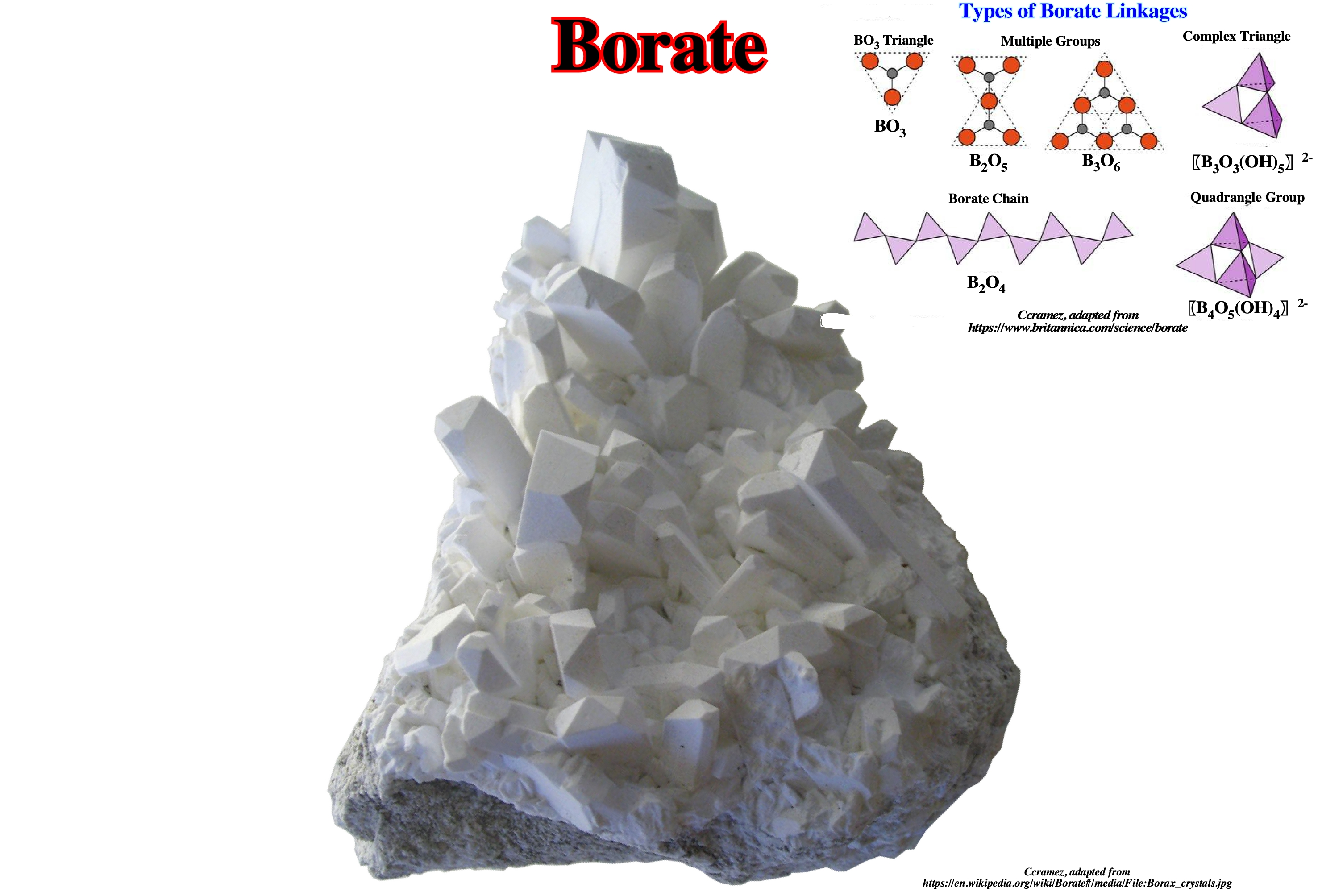
There are about a hundred borates and hydroborates in nature, generally, abundant in certain evaporite formations, fairly soft and not very dense. Common borate salts include sodium metaborate (NaBO2) and borax. Borax is soluble in water, so mineral deposits only occur in places with very low rainfall. Extensive deposits were found in Death Valley and transported out using the famous twenty-mule teams (teams of eighteen mules and two horses attached to large wagons that transported borax out of the Death Valley) from 1883 to 1889. In 1925, deposits were found at Boron, California, on the edge of the Mojave Desert. The Atacama Desert, in Chile, contains, also, mineable borate concentrations.
Boundary Shear Zone
Limit of a shear zone enclosed within the diapir and contains screens or clast trains of country rock. Some boundary shear zones could result from external shear zones becoming entrained in mushroom structures.
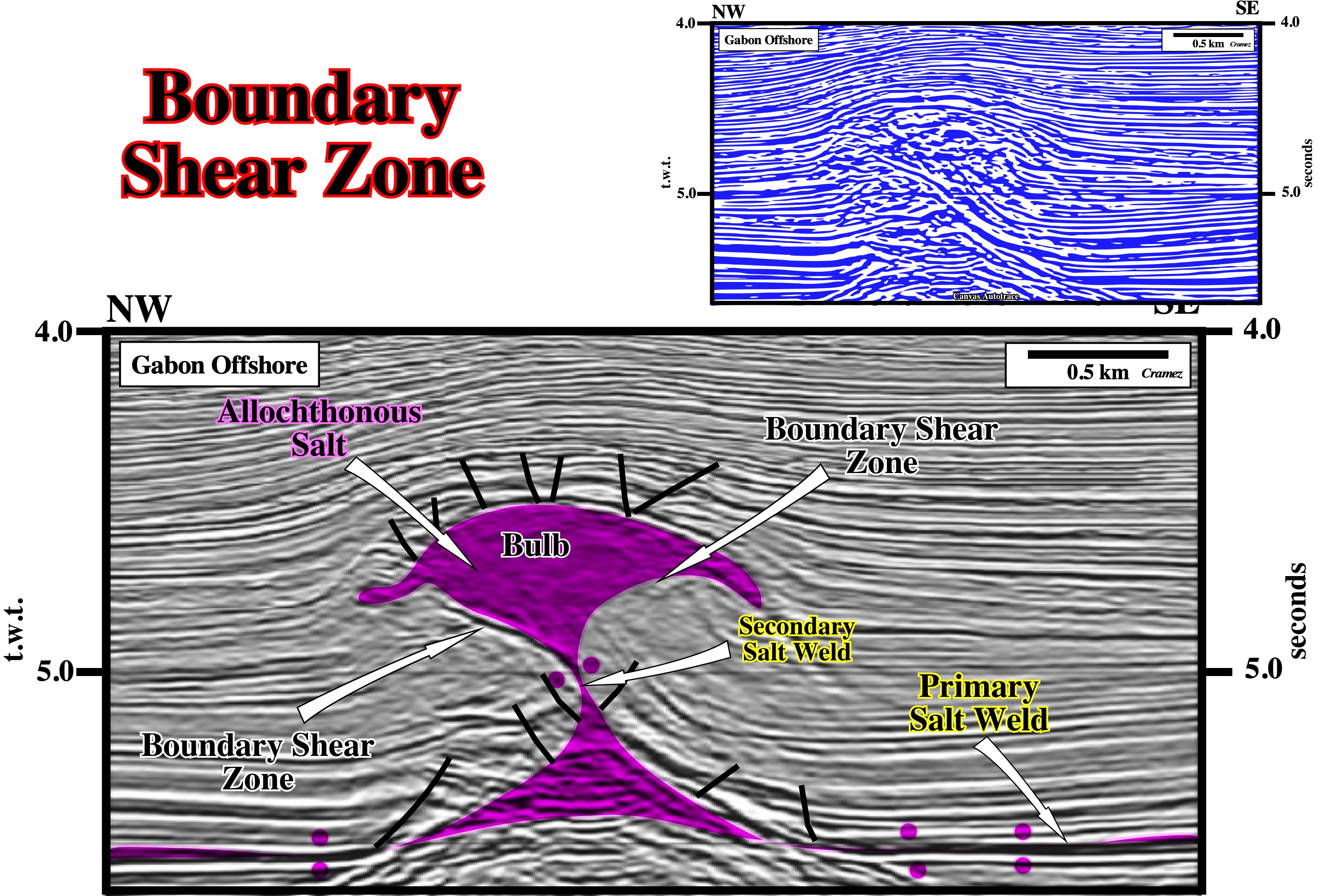
Three types of shear zones (band off highly deformed rock separating two rock masses that have sheared past each other) associated with salt diapirs were recognized by M. Jackson and C.J. Talbot (1991): (i) External ; (ii) Boundary and (iii) Internal. On this preliminary tentative interpretation of Canvas autotrace of a Gabon offshore seismic line, two boundary shear zones can be predicted under the salt bulb, which seems to be disconnected of the mother salt layer (autochthonous salt). A secondary salt weld separates the allochthonous salt from the autochthonous salt, which is, often, reduced to a primary salt weld. The normal faults lengthening the overburden are well recognized.
Brine
A term used for pore fluids in deep sedimentary basins, stratified hot fluids in restricted basins such as the Red Sea, oil-field water, and geothermal mineralizing fluids. It denotes warm to hot highly saline waters containing Ca, Na K, Cl, and minor amounts of other elements. In oceanography, it can corresponds to seawater that, owing to evaporation or freezing, has considerably more than the average concentration of dissolved ions, i.e., a salinity of 40 or higher being the highest salinity commonly found. Similarly, this term can correspond to seawater beneath the seabed in sediments or rock fractures with a high concentration of dissolved ions due to water-rock reactions within the ocean floor.
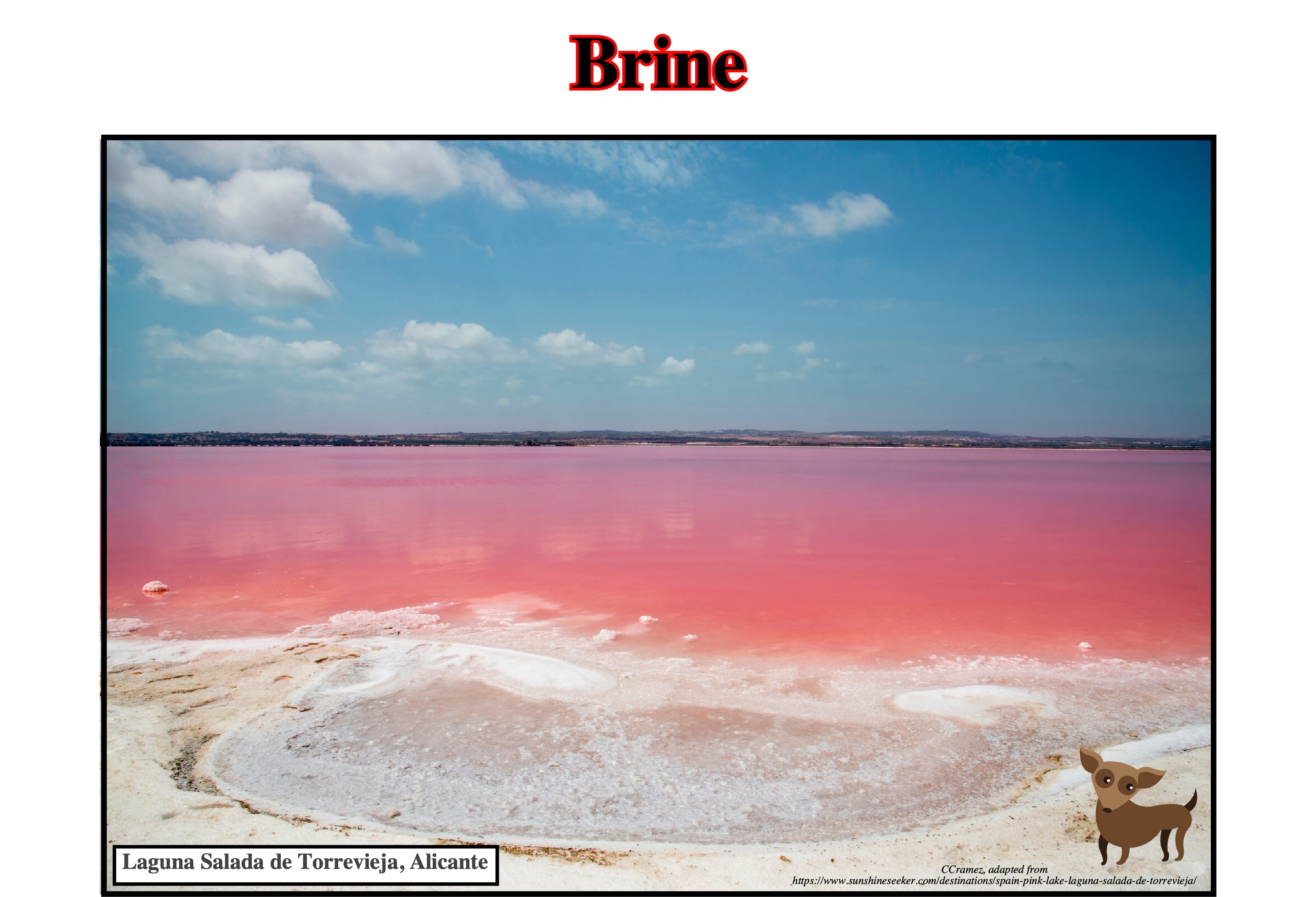
The unusual pink color of the Laguna Salada de Torrevieja (Spain) is caused by pigments of the Halobacterium bacteria and a microalgae called Dunaliella Salina, both which somehow manages to live and thrive in very salty environments. The brine composition depends, often, on the nature of the substratum. Spilitized basalts interacted with brines to create distinctive CaCl2-rich potash evaporites of hydrothermal origin.
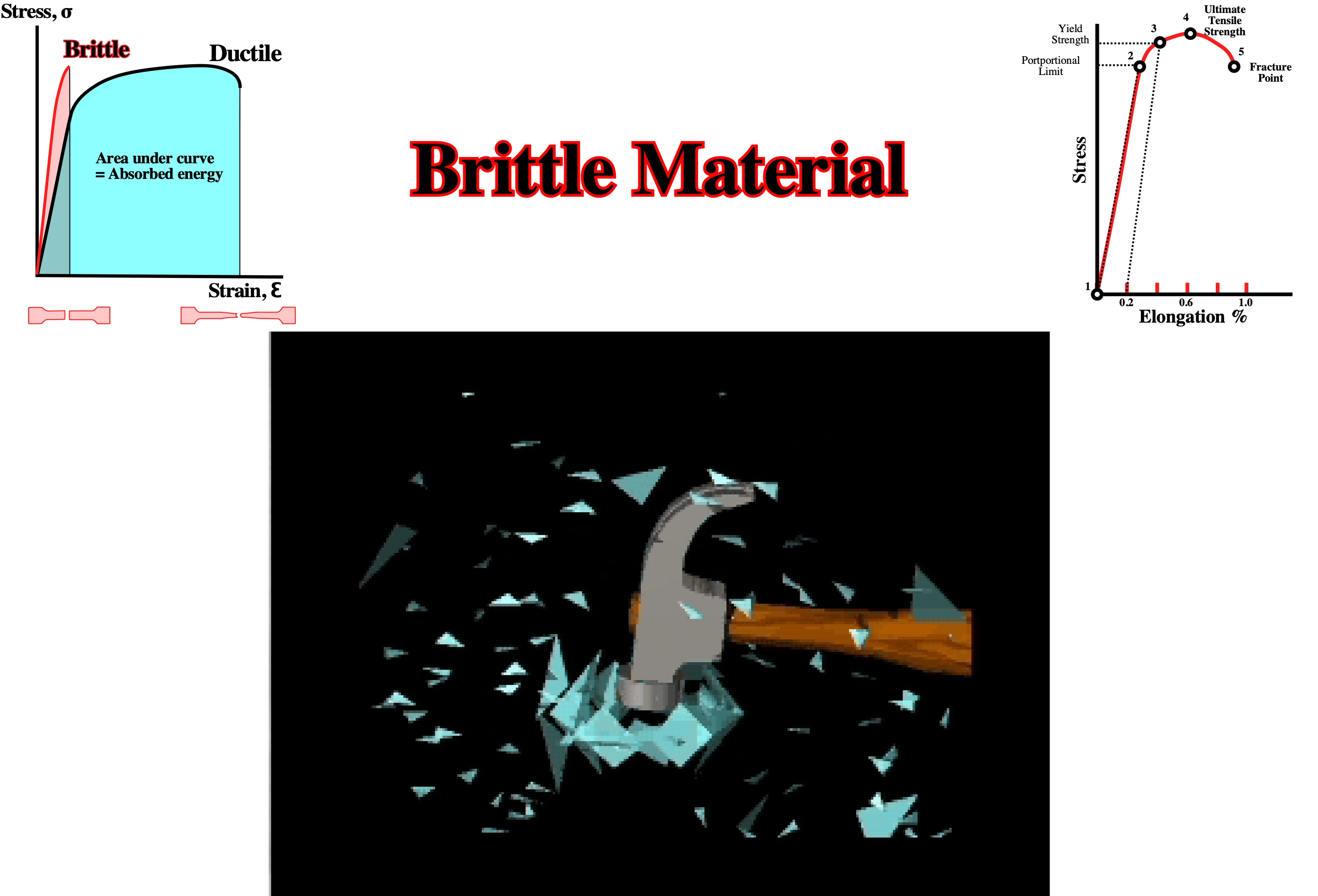
Brittle Deformation
When deformation or strain reaches less than 3-5% and the rock fractures. A brittle or rigid material when tested to failure, under conditions of triaxial compression, exhibits a relationship between principal stresses at failure, which is represented by the empirically derived linear equation: σ1=σ0+ kσ3. Where σ0 is the uniaxial compressive strength k is a constant.
Some rock types exhibit a non-linear relationship between principal stresses at failure. In these types of tests the specimens fail in shear. Usually, the specimens fail along only one shear plane. Occasionally, specimens exhibit two conjugated shear planes, with opposite shear sense. The angle between them, which is, often, considerably less than 90°, is bisected by the axis of maximum principal stress.
Brittle Era (Jackson, M. P. A., 1995)
In the history of salt tectonics three eras can be considered: (i) Pioneering era, between 1856 and 1933, (ii) Fluid era, between 1933 and roughly 1898 and (iii) Brittle era. The brittle era became evident about 1989 is, actually, rooted in the 1947 discovery that a diapir stops rising if its roof becomes too thick. Such a notion was heretical in the fluid era. Stimulated by sandbox experiments and computerized reconstructions of Gulf Coast diapirs and surrounding faults, the onset of the brittle era yielded regional detachments and evacuations surfaces (salt welds and fault welds) along vanished salt allochthonous, raft tectonics, shallow spreading, and segmentation of salt sheet.
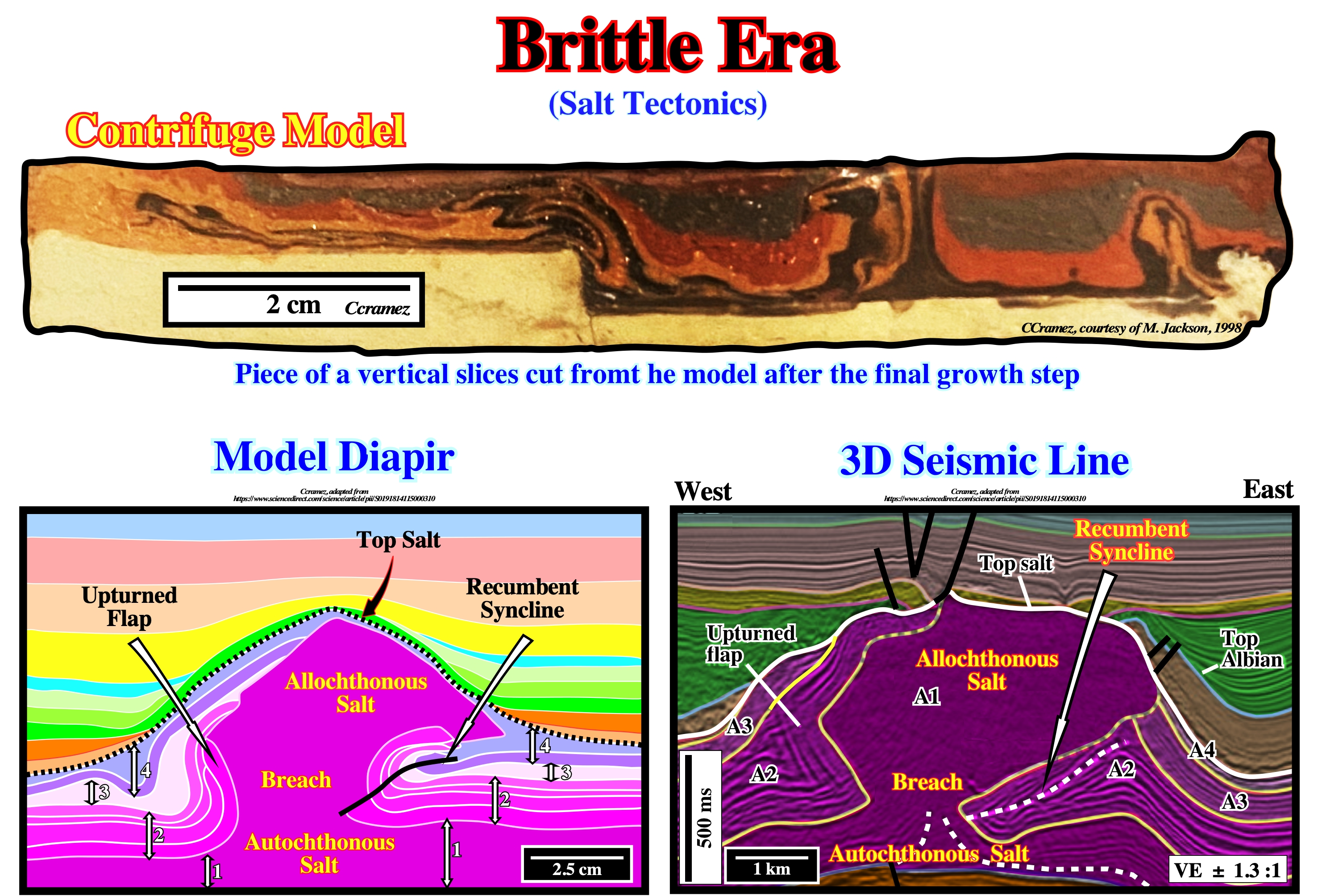
The fluid era was driven by R-T instabilities, i.e., the density inversion between the overburden and the buoyant salt. In the Brittle Era, geoscientists incorporate in their numerical models both the viscosity and density contrasts, found major fracturation of the salt mass as the more buoyant, halite rich, evaporites were, preferentially, expelled upward. Layer models with thin interlayer denser than the viscous salt form major folds within evaporites disrupting the stiff interlayer as illustrates above. Some of the complex salt structures found in 3D seismic lines of certain deep offshores (Brazil, Angola, etc) can, tentatively, be interpreted as suggested by the numerical and sandbox models, i.e., apparently, independently of a significant regional shortening (compressional tectonic regime), in other words considered as antiforms and synforms and not as anticlines and synclines.
Buckle Folds (Bates, R. L. and Jackson, J. A., 1980)
Folds that occur in response to end-loading of competent layers.
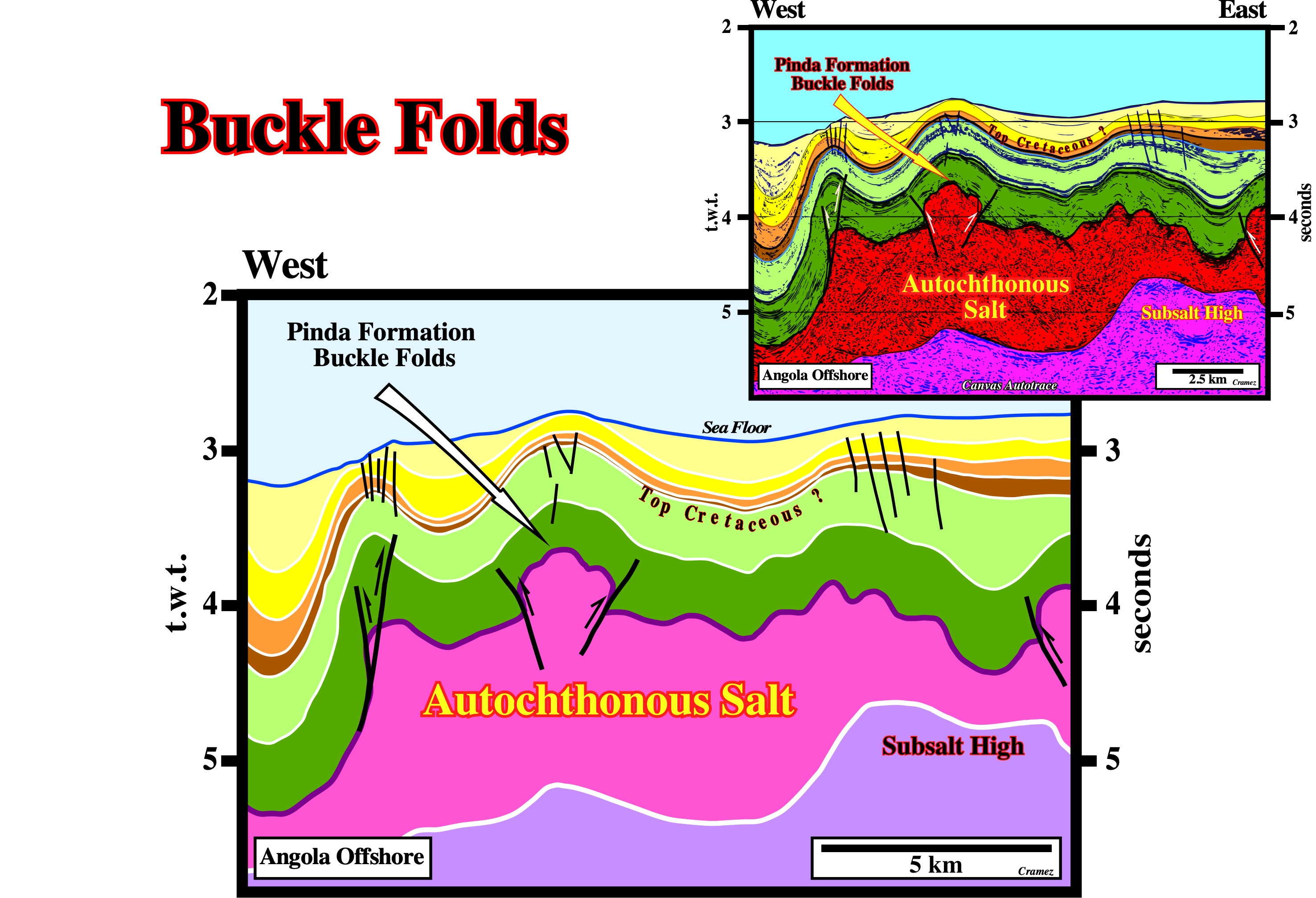
In Angola deep water, the buckle folds visible within the Pinda formation (lower green seismic interval) should not be confused with the larger Upper Tertiary folds affecting the overburden. Buckle folds occurs due to axial loading. Bending folds occurs due to transverse loading. Buckling indicates failure, irrespective of magnitude. Bending is natural under transverse load and is not considered as failure as long as the deflection is within limits. Buckling is a associated with a shortening (anticlines and synclines). Bending is associated with a lengthening (antiforms and synforms). Take note that on this preliminary tentative geological interpretation of a Canvas autotrace of an Angola deep water seismic line, the thickness of the allochthonous salt is the result of a stacking of salt thrust induced by a local compressional tectonic regime (abyssal plain) created as a response to the updip lengthening of the overburden (continental slope).
Bulb
Overhanging, swollen crestal portion of a salt diapir. Extremely broad bulbs grade into salt sheets.
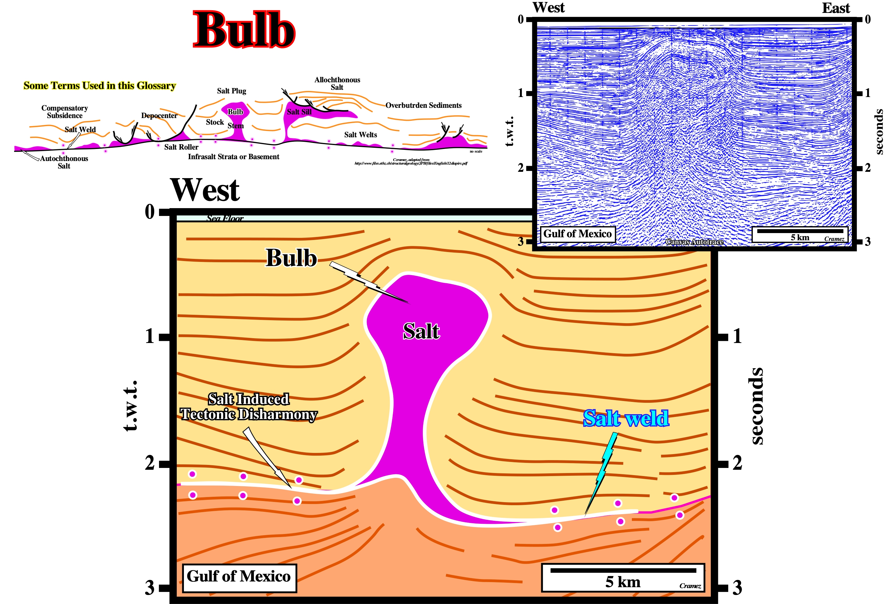
Salt flowage created two salt welds (underlined by the small circles), which mark a major tectonic disharmony, and a diapiric salt structure, in which the swollen crestal portion -the bulb- is quite evident. The internal configurations of the postsalt sediments suggest the overburden is composed by two major stratigraphic intervals; (i) synkinematic with a divergent configuration and (ii) a postkinematic with parallel internal configuration. On this preliminary tentative geological interpretation, the salt induced tectonic disharmony, is here, in great part, underlined by a primary salt weld. The deformation of the cover (salt + overburden) is, completely, different of the deformation of subsalt strata.
Buoyancy
Instability caused by the tendency of an overburden to sink into less dense source layer. Buoyancy is driven by lateral pressure gradients caused by structural relief in the upper surface of the salt layer. The buoyancy concept is, generally, linked to Rayleigh-Taylor instability, which, originally, applied to two viscous layers, but also applies to multilayers having other properties. In both cases, the density inversion is primary because of compositional differences.
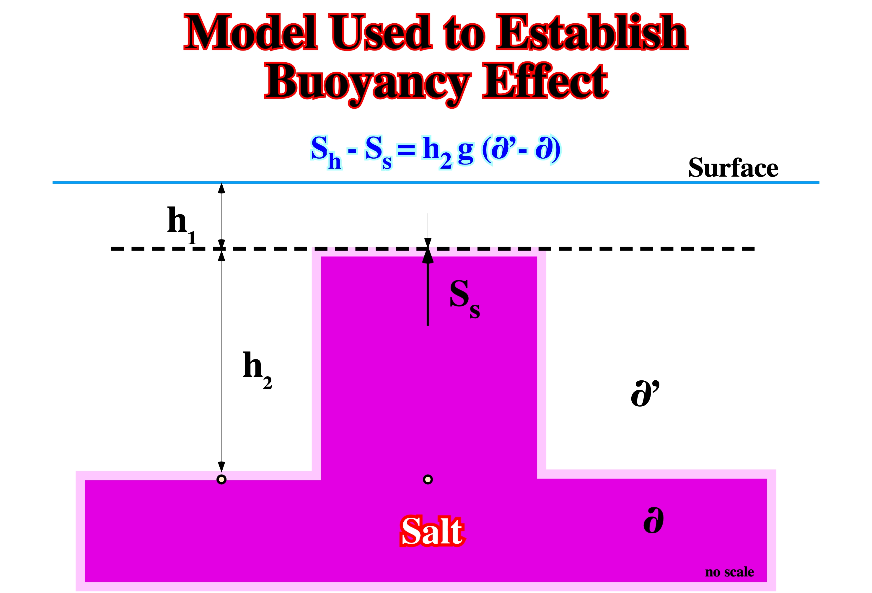
In a static situation, there is a tendency for the upward pressure in the salt column (Ss), at the interface at depth h1, to exceed the downward gravitational load (Sh) by the amount: Sh-Ss=h2g(∂‘-∂), which corresponds to the buoyancy effect .
Burial (Salt sheets)
Allochthonous salt sheets are, usually, emplaced as extrusive salt glaciers at the sediment-water interface, where a thin carapace of pelagic sediments prevent massif dissolution. Different model have been proposed to explain the progressive burial of the extrusive salt sheets.
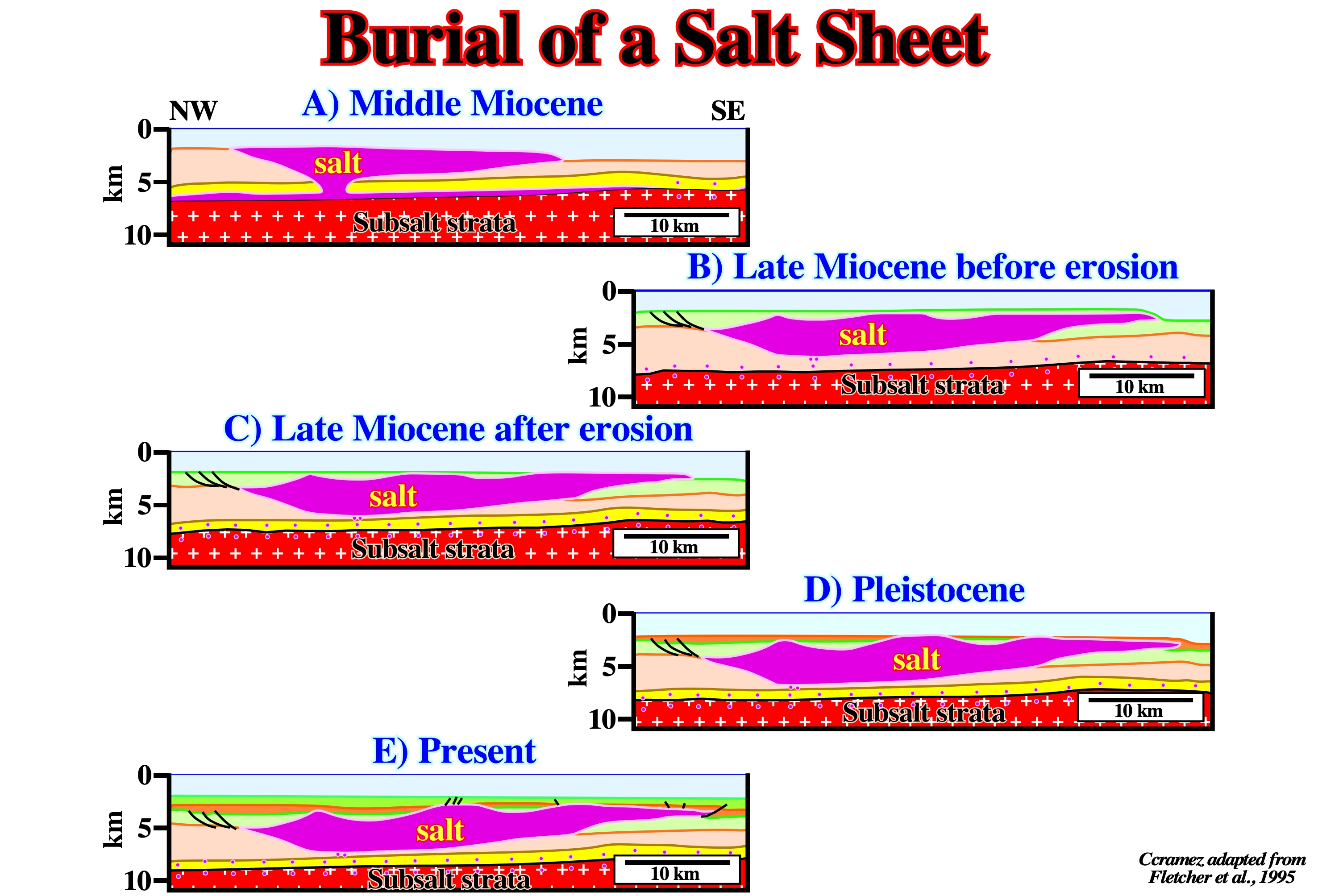
This restoration of a seismic line of the Gulf of Mexico proposed by Fletcher (1995) illustrates the burial of a salt sheet. Depth conversion was done using constant layer velocity. All blocks were restored by vertical simple shear. The effects of decompaction are not included. The positions of the three mini-basins on the top o the salt sheet in the restoration were calculated during mathematical models.