
Paleostress Tensors
Synonym of effective stresses, σ1, σ2 and σ3, i.e., the stresses which deform the sediments. Generally in salt tectonics, σ1 is vertical and σ2 and σ3 are horizontal and equals. See: Effective stress ellipsoid.
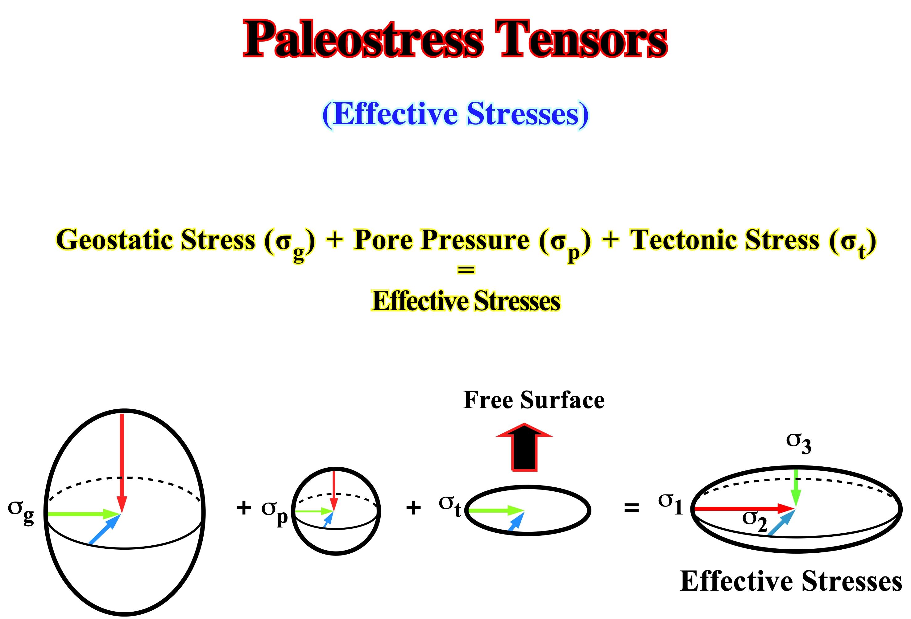
The effective stress is the result of the geostatic stress (σg) plus the pore pressure (σp) plus the tectonic stress (σt). The effective stresses are the responsible for rock deformation. Conventionally: (i) When σ1 is vertical, the effective stresses are extensional and the sediments will be lengthened ; (ii) When σ1is horizontal, the effective stresses are compressional and the sediments will be shortened.
Paleozoic
Post Rodhinia or Pre-Pangea continental encroachment stratigraphic cycle deposited in association with the older Phanerozoic first order eustatic cycle.
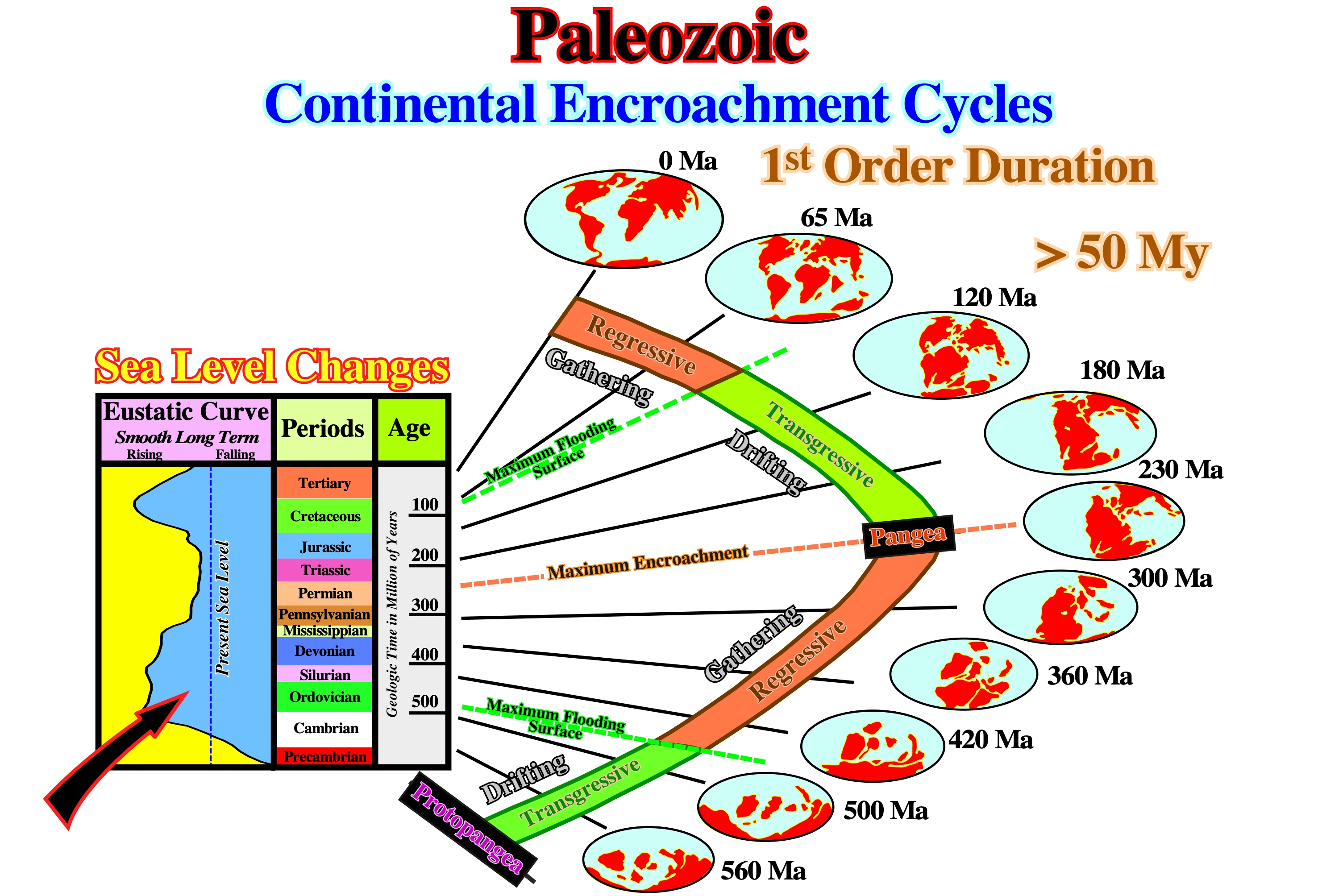
Paleozoic is an erathem of the Standard Global Chronostratigraphic Scale, above Precambrian and below Mesozoic. The time during which Paleozoic rocks were deposits, i.e., from about 570 Ma to 245 Ma. In eustatic terms, Paleozoic corresponds to the post Rodhinia stratigraphic cycle deposited during the older Phanerozoic first order eustatic cycle.
Palinspathic Section (Kay, G. M., 1945)
A cross section in which the represented features have been restored as nearly as possible to their original geographic positions, before the rocks of the crust were shortened by folding, or by thrusting.
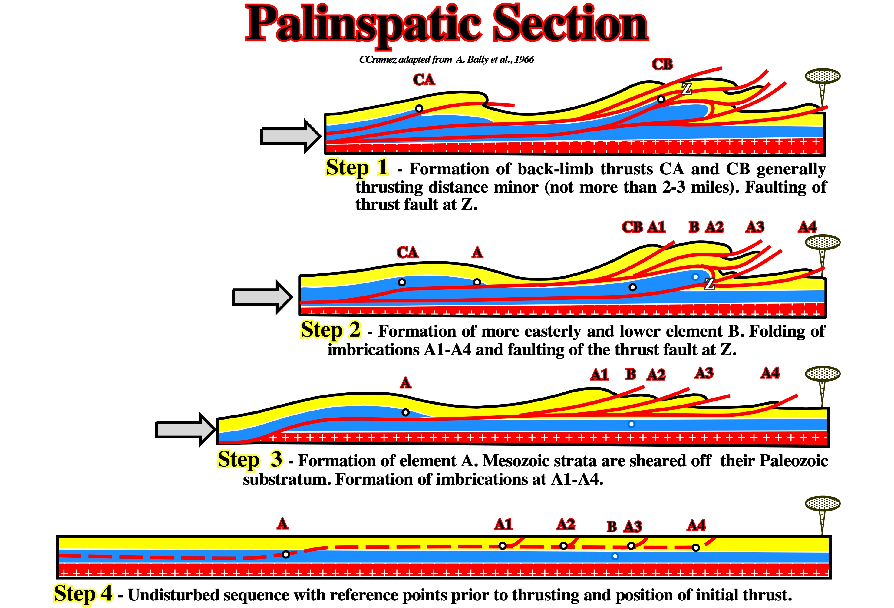
This palinspasthic reconstruction proposed by Bally, in 1966, implies four main steps of deformation in the Rock Mountains. Deformation proceed from west to east, concomitant with the formation and migration of the foredeep basin.
Passive Diapirism
Synonym of Downbuilding.
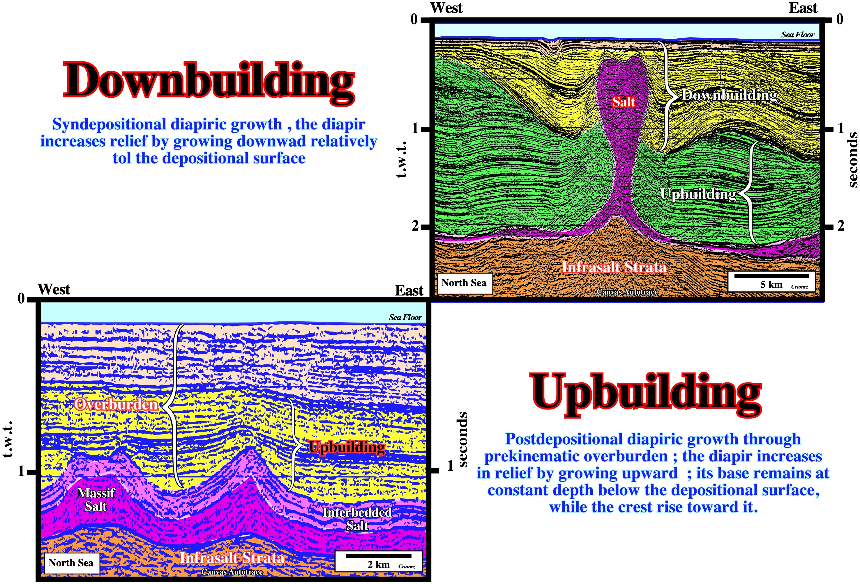
The term passive diapirism or passive piercement is more used than downbuilding. I prefer the term downbuilding because it, clearly, indicates the salt movement induces a compensatory subsidence creating a synkinematic depocentre around the salt diapir. On the tentative geological interpretations illustrated above, upbuilding (active piercement or active diapirism) and downbuilding (passive diapirism or passive piercement) are recognized, easily, by the geometry and thickness variation of the prekinematic and synkinematic overburden intervals.
Passive Piercement (Jackson, M .P. A. and Talbot, C. J.,1991)
Synonym of downbuilding or passive diapirism. It is, often, defined as a syndepositional growth. The diapir increases relief by growing downward relative to the sedimentary surface. Its base subsides, together with the surrounding strata, as the basin fills with sediments. The diapir crest remains at or just below a thin roof that is, continually, thickened by sedimentation and thinned by erosion or extensional thinning. In other words, in a passive piercement the base of the diapir sinks and the crest remains shallow. In an active piercement (or upbuilding) the base of the diapir stays more or less at fixed depth, while the crest rises.
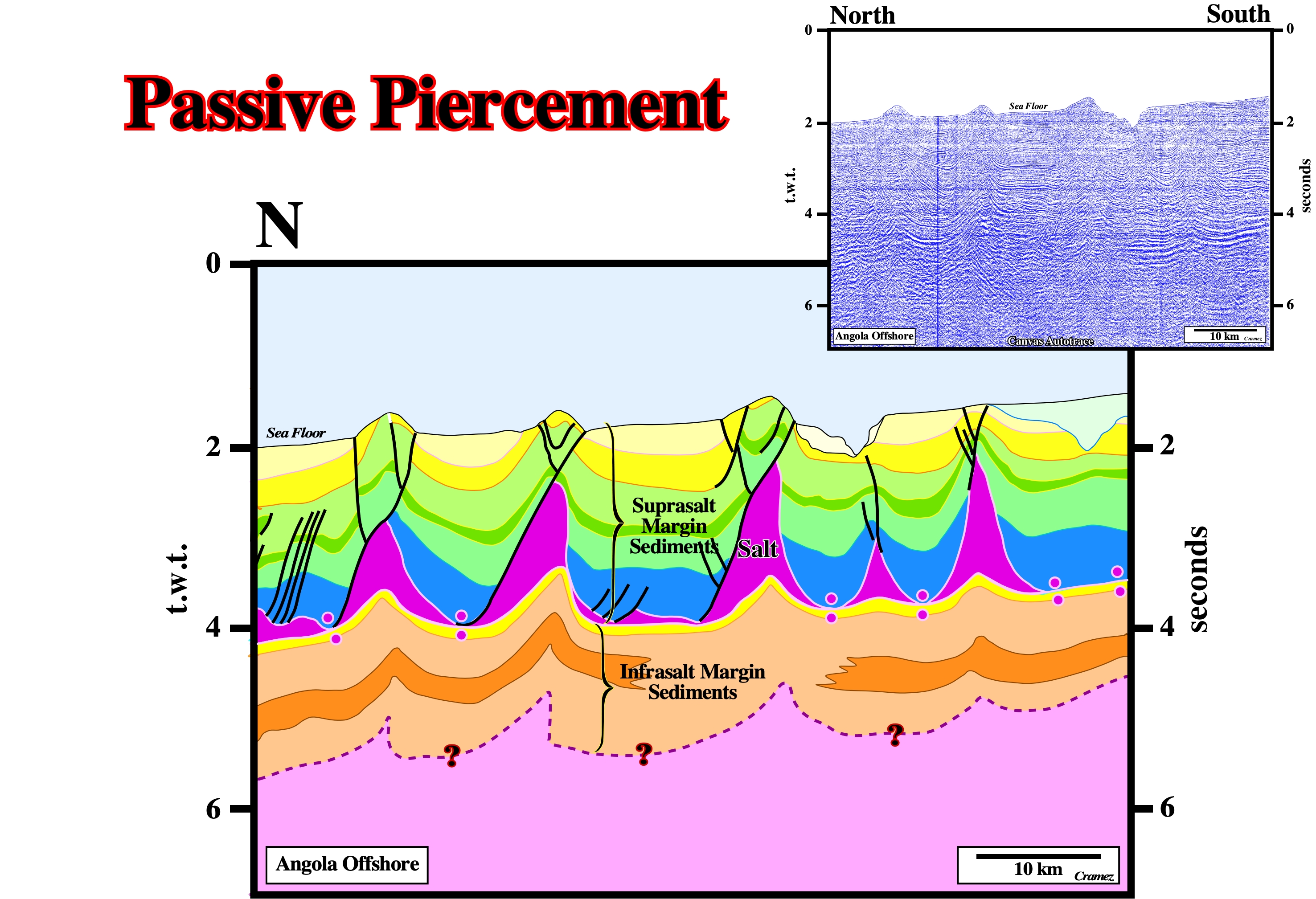
In a diapirism growth, very often, it is quite difficult to differentiate a passive (upbuilding) from an active piercement (downbuilding) as illustrated on this tentative interpretation of a Canvas autotrace of an Angola offshore seismic line. Both geological mechanisms run from quite different initial situations to the same final stage. Only the regional geological knowledge of the area, allows to understand whether the observed (apparent) upbuilding was created by regional extension or by passive piercement. An active piercement implies not only a reduction of the overburden, to accommodate the emplacement of the salt, but also a considerable thickness and strength of overburden must be penetrated and displaced, by the relative weak buoyancy forces of diapirism. The undulation of the seismic horizons below the salt have any geological meaning. They correspond to pitfalls induced by the thickness variation of the salt layer.
Passive Stage
In a passive stage, the extrusive domes do not deform the overburden. Overburden deformation stops once the dome reaches the surface. Then, the dome can become disconnected from the mother salt layer and the upward growing of the dome stops, but lateral salt displacements are possible.
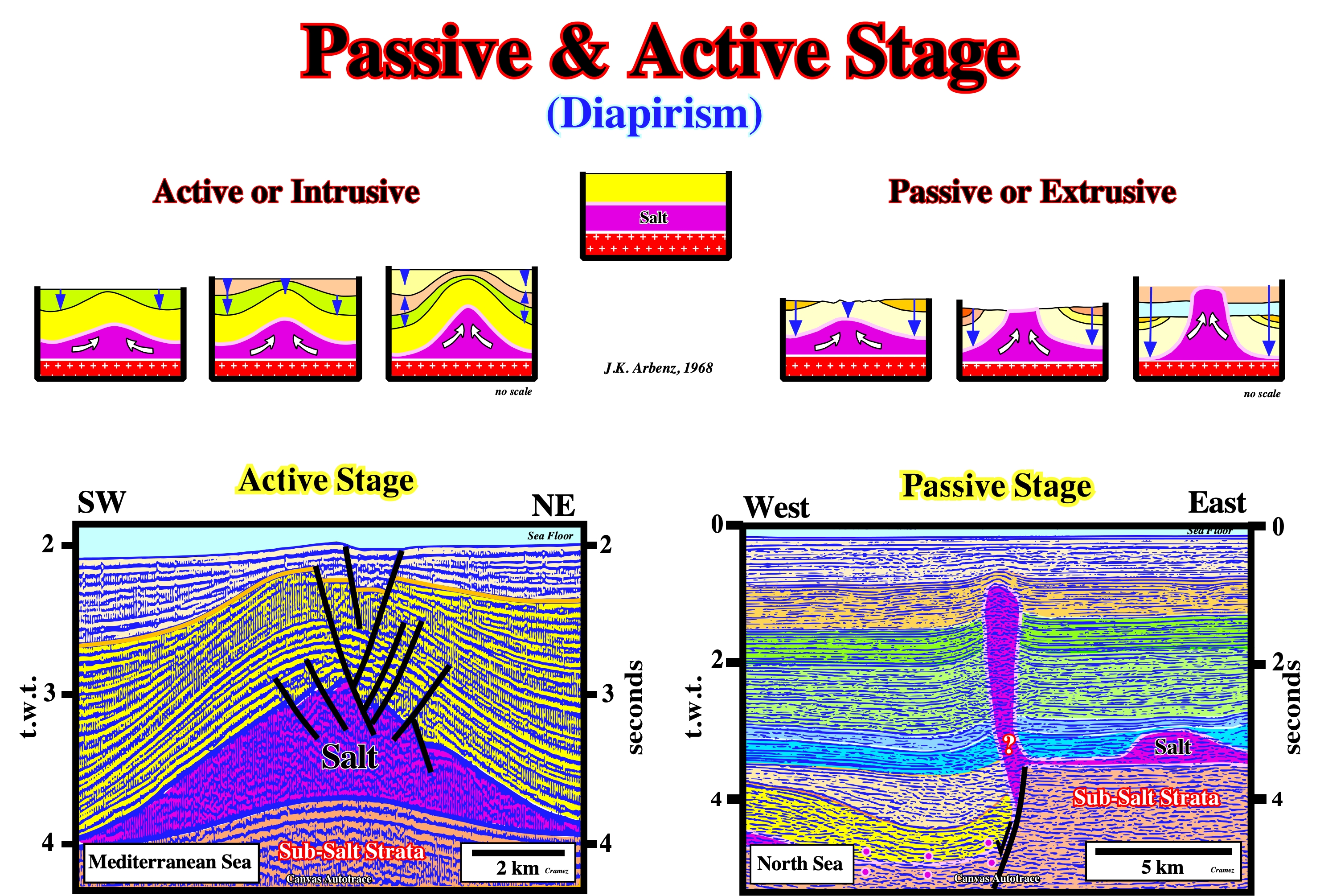
In the passive stage, the upward movement of the salt is coeval with the sediment deposition. In the active stage, the salt movement postdates the deposition of the sediments. In the first case the overburden can be, more or less, undeformed (the thickness of the overburden interval is, roughly, constant each side of the diapirs) or deformed in synforms (synkinematic depocenters). In the second case (active stage), the overburden has an antiform geometry. The salt movement postdates the sediment deposition. Quite often, the two stages are recognized in the evolution of a diapir, with the active stage predating the passive stage. Since an active salt diapir outcrops a passive stage begins.
Perdido Fold Belt (S. Gradmann et al., 2009)
The Perdido Fold Belt (PFB) is a prominent salt-cored deep water structure in the NW Gulf of Mexico. It is characterized by symmetric, kink-banded folds of a 4.5 km thick layer not far from the extensive Sigsbee Salt Canopy.
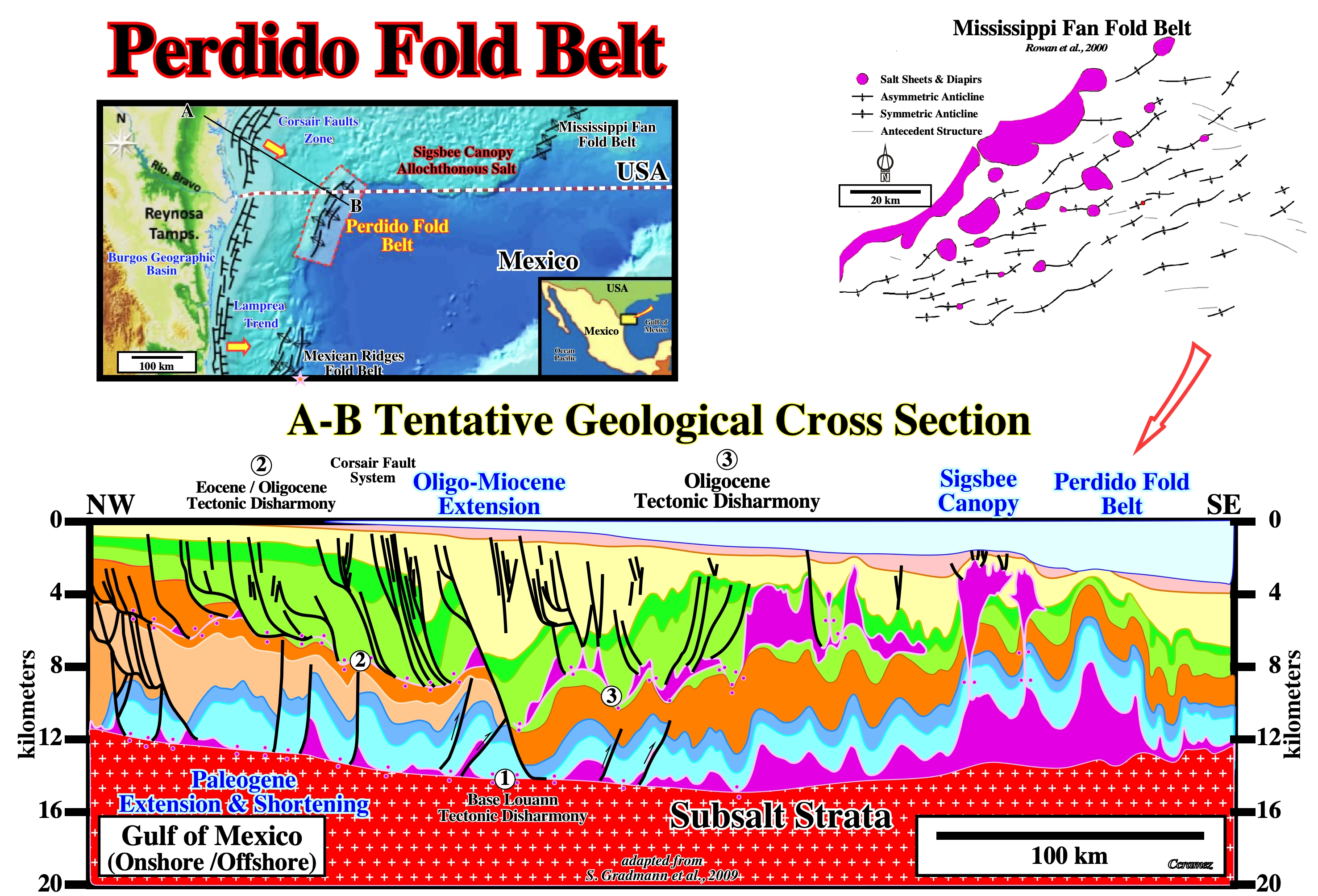
In association with the salt tectonics, at least three fold belts can be recognized on the Gulf of Mexico: (i) Mississippi Fan Folded belt ; (ii) Perdido Fold Belt and (iii) Mexican Ridges Fold Belt. The Mississippi Fan Fold Belts is located in American territorial waters, while the Perdido Fold Belt and Mexican Ridges Fold Belt are located in Mexican waters. Taking into account the tentative geological cross section, the Perdido Fold Belt, which located in the distal section of the allochthonous Louann salt, can be, easily, interpreted as a local compressional tectonic regime induced as a counterpart of the updip extension, i.e., the updip lengthening of the sediments created by halokinesis and salt tectonics is compensated by a distal shortening of the sediments. The same seems true for the other Gulf of Mexico fold belts. Similar compressional tectonic regimes are found in South Atlantic offshores, particularly in Angola and Brazil. On this cross section, it is interesting to recognize the different tectonics disharmonies, salt welds, as well as, the successive depocenters. On detailed seismic lines of the Perdido fold belt, its is quite easy to individualize the prekinematic layers from the synkinematic and postkinematic layers.
Peripheral Sink
Locally thickened, synkinematic strata accumulating in a rim syncline as a result of salt withdrawal. Peripheral sinks may have any shape in plan and are classified according to thickness variations within them. The mechanical significance of peripheral is now being questioned.
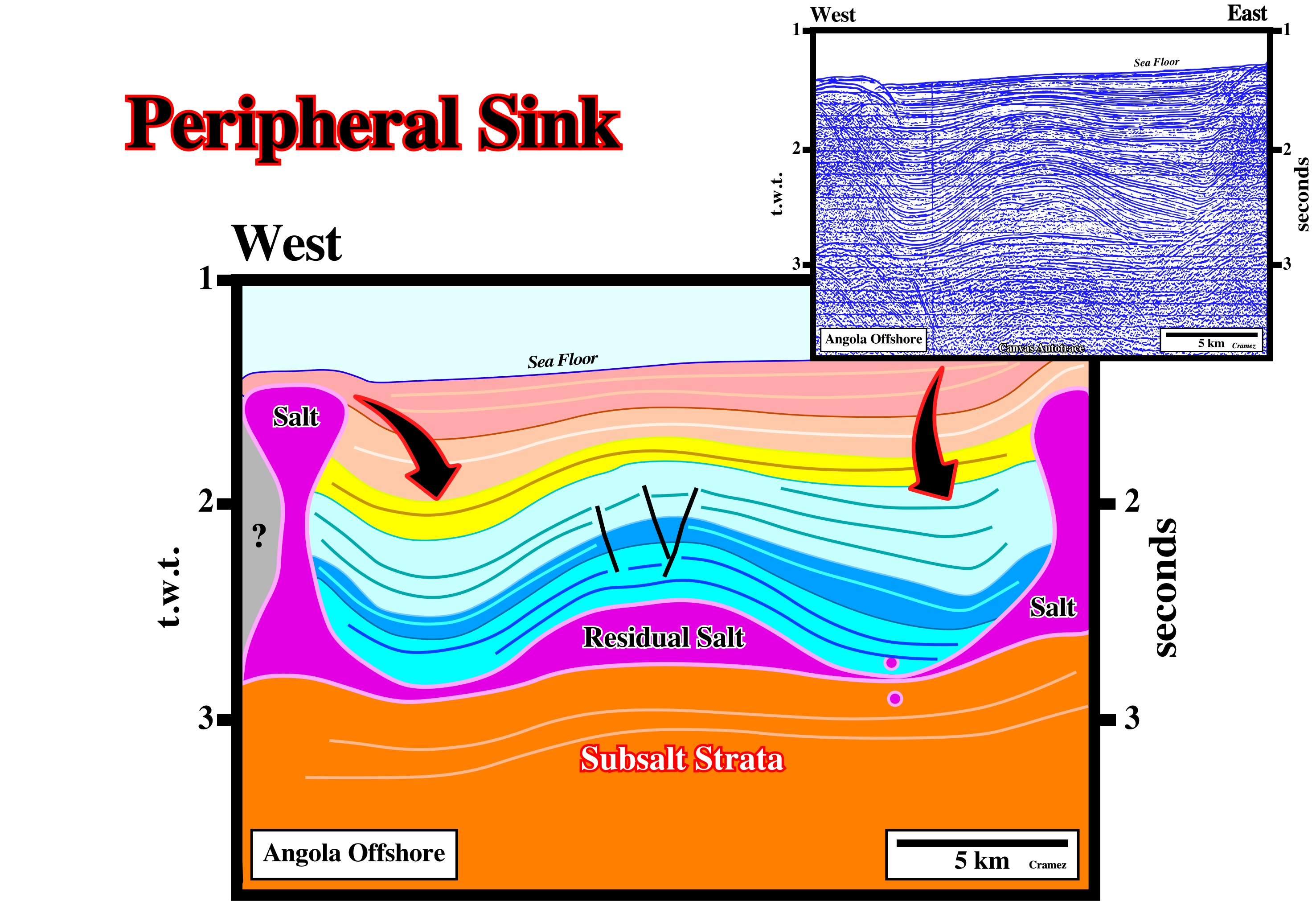
The compensatory subsidence created by the flowage of the salt created an antiform structure surrounded by two asymmetric peripheral sinks. This antiform structure of the deep-water Angola offshore, known since 1968 (Seffel seismic lines), became far-famed of all geoscientists working in West Africa offshores. In fact, this extensional structure, which does not correspond to real turtle back (there is no inward thickening of any interval) was drilled and a several significant oil pools were discovered, by serendipity, before the wildcat reached the original target (blue seismic interval).
Perisutural Basin
Basin associated with the formation of a megasuture, but located outside of it. Foredeep, fore-arc and Chinese-type basins are the main basins of this type.
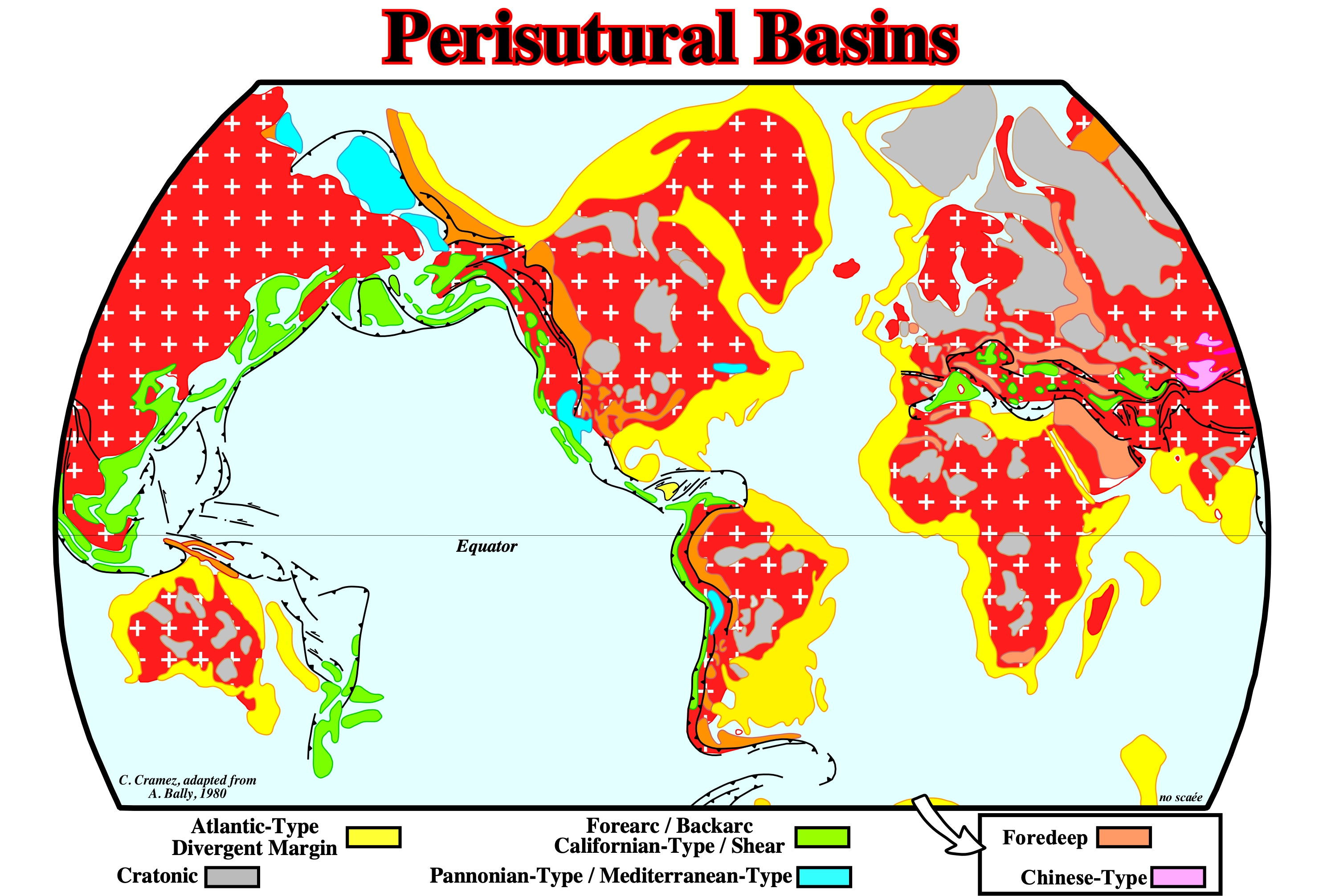
On this map only the Mesozoic-Cenozoic sedimentary basins are illustrated. To located the Paleozoic sedimentary basins, it is necessary to reconstruct the Paleozoic megasuture, which was completely distorted by the Pangea breakup and subsequent drifting of the Mesozoic-Cenozoic continents. The perisutural basins, which developed at the periphery of the megasuture, in association with a B-type (Benioff) or A-type (Ampferer), are, mainly, foredeep (foreland basins) and forearc basin (external to the volcanic arc).
Permian Salt Deposits
During the Permian, a period of immense salt accumulation, several vast evaporitic basins, such as the European, Central European, Midcontinent and Peru-Bolivian Basins were formed. Salt deposits are also known from the following geographic basins: Alpine, Moesian, Chu-Sarysu, Supai and North Mexican. Fourteen Permian basins with gypsum and /or anhydrite occurrences were recognized: Darvaza, Karasu-Ishsay, Dobruja, Rakhov, Mecsek, Dinarids, North Italian, Spitsbergen, East Greenland, Sverdrup, Rio Blanco Parnaiba, Arabian and Browse Basins.
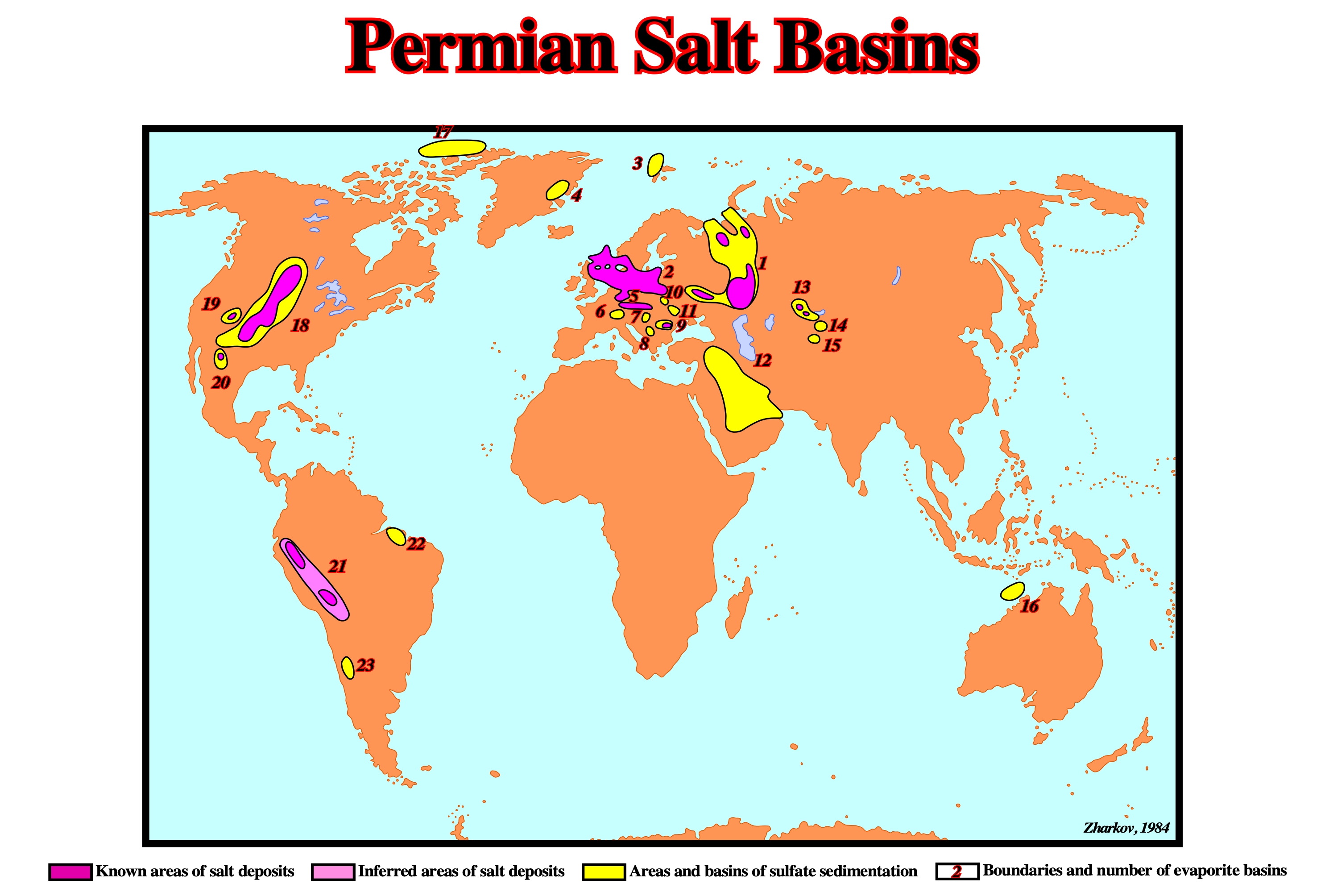
The distribution of Permian evaporites can be summarized as follows: (1) East European ; (2) Central European ; (3) Spitsbergen ; (4) East Greeland ; (5) Alpine ; (6) North Italian ; (7) Mecsek ; (8) Dinarides ; (9) Moesian ; (10) Rakhov ; (11) Dobruja ; (12) Arabian ; (13) Chu-Sarysu ; (14) Karasu-Ishsay ; (15) Darvaza ; (16) Browse ; (17) Sverdrup ; (18) Midcontinent ; (19) Supai ; (20) North Mexican ; (21) Peru-Bolivian ;(22) Parnaiba ; (23) Rio Blanco.
Petroleum Geology
The study of the origin, migration and accumulation of oil and gas.

In petroleum geology the main target is to determine the more likely petroleum systems of an area. Petroleum systems are referred, often, by the names of the geological formations of the source-rock and rock-reservoir. For instance, in the Maturin geographic basin (Venezuela), the "La Luna / Naricual" petroleum system means the source-rock is within the Luna formation and the rock-reservoir in the Naricual formation. Geoscientists confuse, often, a petroleum system, such as La Luna / Naricual with the La Luna generator petroleum subsystem (source-rock). La Luna petroleum system does not exist. A system, in the holistic or contextual (systemic) method, is a whole and not a part. A petroleum system includes all the elements and geological processes that are essential to the existence of an accumulation of oil or gas in nature. The basic elements include: (i) Source-Rock ; (ii) Reservoir-Rock ; (iii) Sealing-Rock ; (iv) Trap and (v) Migration pathways along which hydrocarbons can migrate from the source-rock into the reservoir-rock, where the trap is located (do not confuse source-rock with potential source-rock). All these elements must be, correctly, placed in time and space, so the organic matter included in the source-rock can be converted into an petroleum accumulation. A petroleum system exists when all the basic elements exist or are thought to exist. A petroleum system (whole) consists of two large subsystems: (a) Generating Subsystem and (b) Trap/Migration Subsystem, which in turn are complex and interdependent,i.e., a petroleum system is, much more, than a simple sum of subsystems. Magoon (1987) considered three types of petroleum systems as a function of the degree of certainty: (1) Known Petroleum System (!), when the correlation between the source-rock and hydrocarbons is known, in particular by biomarkers (in the case of petroleum) ; (2) Hypothetical Petroleum System (.), when there is no correlation between source-rock and hydrocarbon and (3) Speculative Petroleum System (?), when the petroleum system is based just on geological or geophysical data, which still have not been tested by the exploration operations.
Phanerozoic
An enothem of the Standard Global Chronostratigraphic Scale including the rocks in which the evidence of the life is abundant. It comprises the Paleozoic, Mesozoic and Cenozoic erathems; also the time during which these rocks were formed, the Phanerozoice Eon.
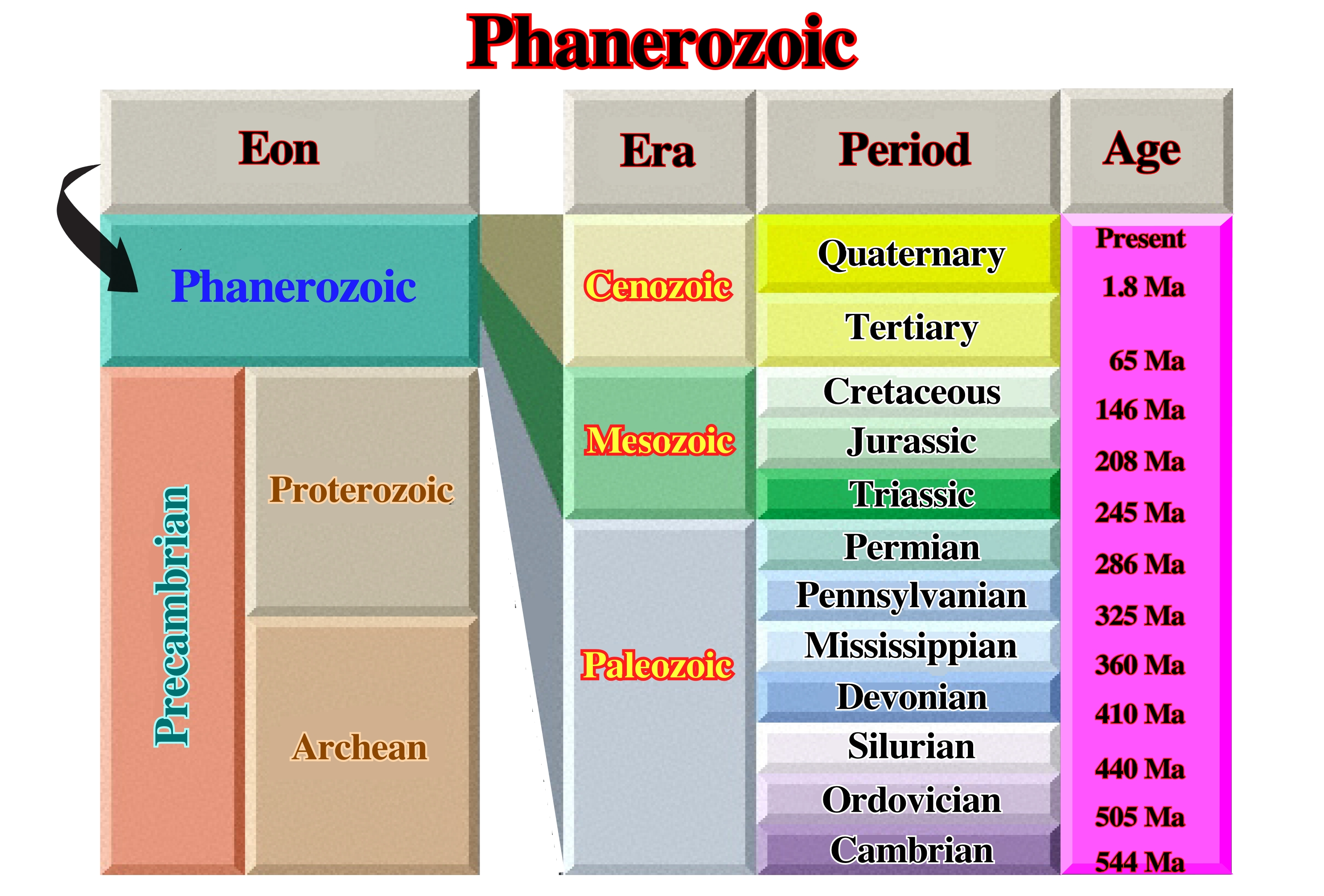
As illustrated, the Phanerozoic comprises the Paleozoic, Mesozoic and Cenozoic eras. At the eustatic standpoint, The Phanerozoic corresponds to the two first order eustatic cycles recognized after the break-up of the Rodhinia or pre-Pangea supercontinent.
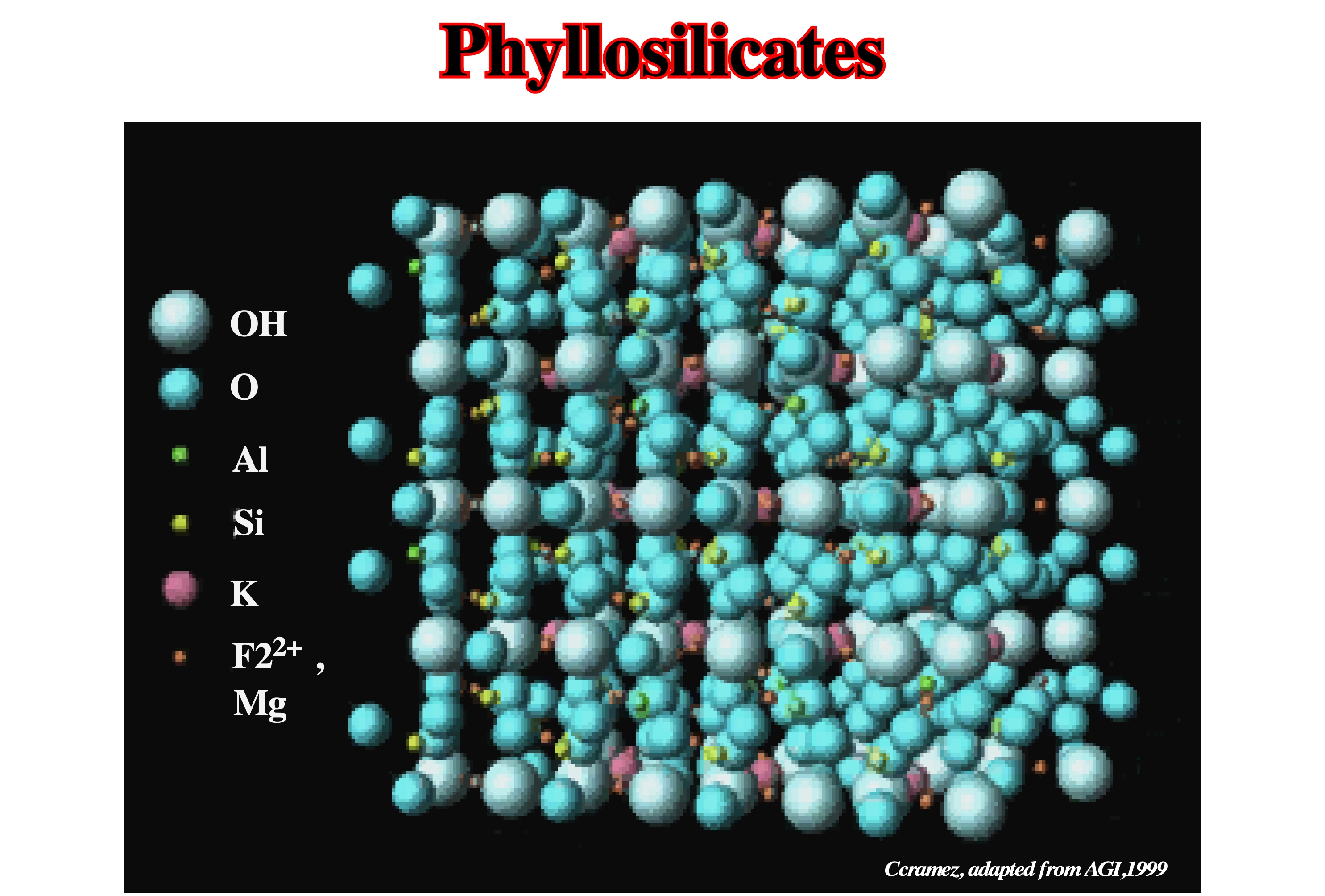
Phyllosilicates
A class or structural type of silicates characterized by the sharing of three of the four oxygens in each tetrahedron with neighboring tetrahedra, to form flat sheets. The S:O ratio is 2.5.
The phyllosilicates exhibit perfect cleavage. They have a lamellar atomic structure where the sheet is constituted by SiO4 tetrahedra whose bases, resting in the same plane are linked by their three vertices. The oxygen atoms of these bases are in contact and arranged at the tops of regular hexagons. The oxygen at the tops of the tetrahedrons form larger regular hexagons, at the centers of which are housed oxhydriles OH or fluorine ions. This sheet, also called a tetrahedral layer, can be defined from a centered rectangular mesh of parameters a = 0.52 nm (2 times the diameter of the oxygen ion) and b = a√3 = 0,9 nm. It constitutes an infinite planar macroanion whose pattern (content of the mesh) has the chemical composition Si4O10 (OH) 26-, and, in this case, the layer is said to be tetrasilicon; a quarter or half of the Si atoms can be replaced by Al atoms, the units become AlSi4 O10 (OH) 27- in the trisilicon layer and Al2Si2O10 (OH) 28- in the disilicon layer (https://www.universalis.fr/encyclopedie/silicates/4-les-phyllosilicates/). An example of phyllosilicates is the micas that crystallize in forms, apparently, orthorrombic or hexagonal but, really monoclinic.
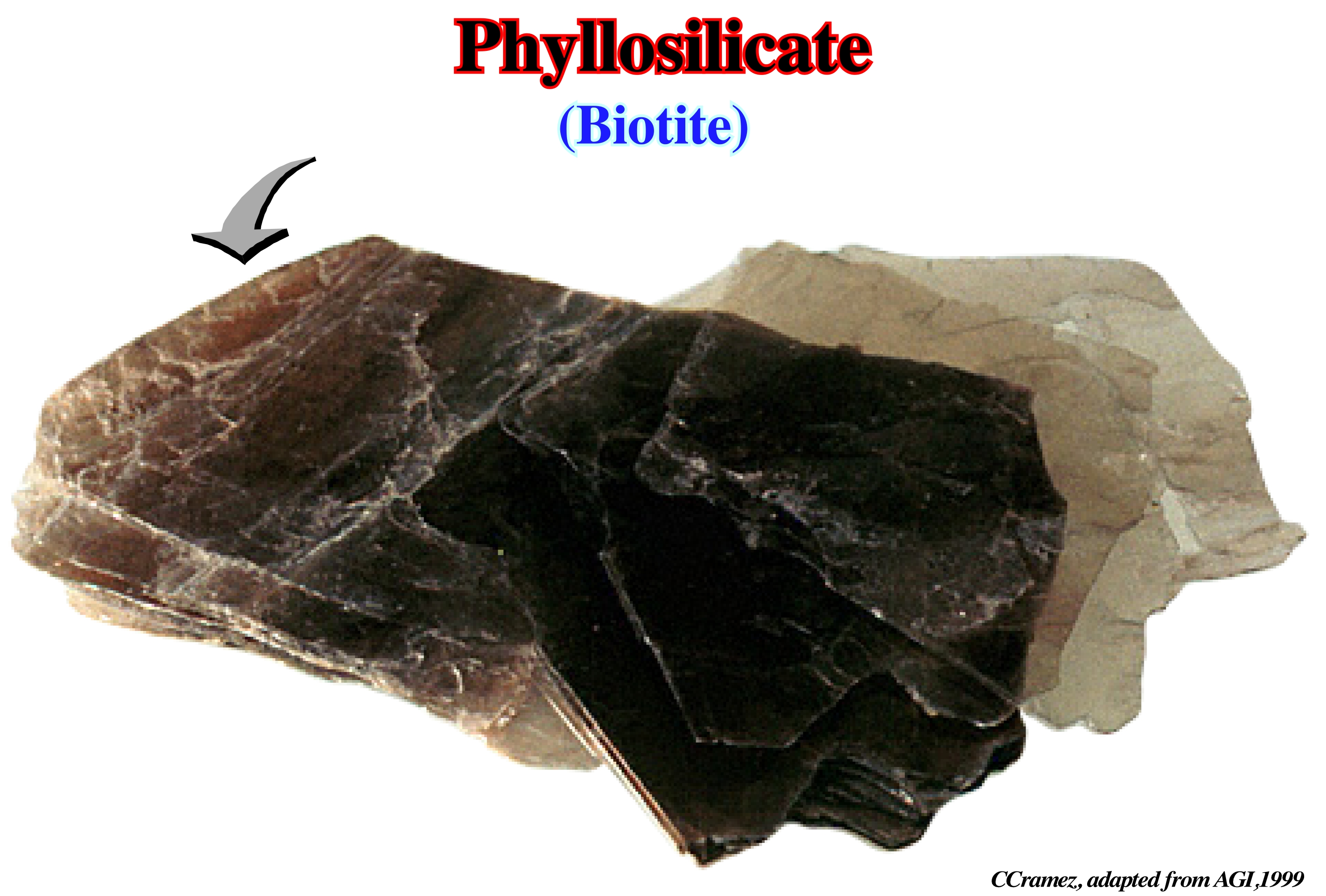
Biotite is a widely distributed and important rock-forming mineral of the mica group. It is, generally, black, dark brown, or dark green monoclinic and forms a constituent of crystalline rocks or a detritic constituent of sandstones and other sedimentary rocks. Biotite is useful in potassium-argon method of age determination.
Pillow (Salt)
See: Salt Pillow.
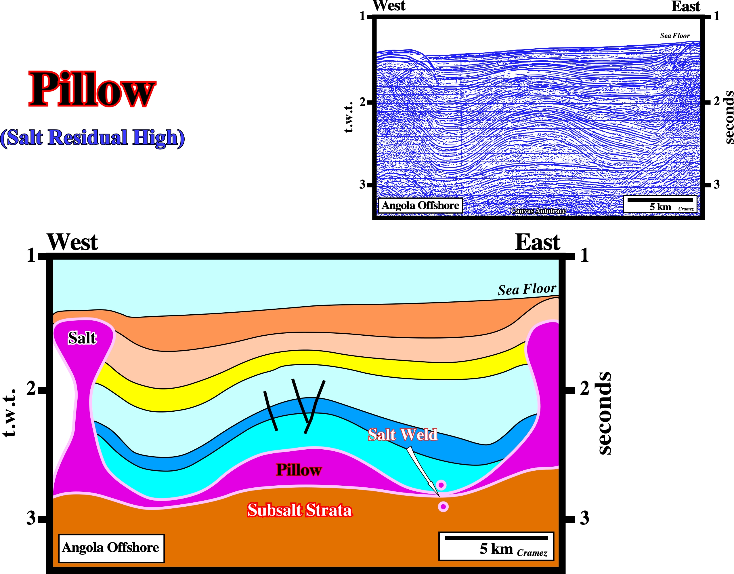
On this tentative geological interpretation of a Canvas autotrace of a Seffel (1968) unmigrated seismic line of the deep Angola offshore, Petrangol (Fina) and Total CAP (today Total SA) geoscientists recognized a large salt pillow antiform structure (residual salt high) in the core of a pseudo turtle back structure (there no layers thickening inward as in a really turtle back). Almost thirty years later, when the drilling technology allows to drill under such an important water depth, this structure was drilled by the French oil company ElF (today Total SA), discovering,mainly, by serendipity, the Girassol oil field, which is, basically, a stratigraphic turbidite oil accumulation, genetically, independent of the overburden antiform (the target of the drilling proposal). The antiform geometry gives just a structural component to the potential stratigraphic traps.
Pioneering Era (Jackson, M. P. A., 1995)
In the history of salt tectonics three eras can be considered: (i) Pioneering era, between 1856 and 1933, (ii) Fluid era, between 1933 and roughly 1898, and (iii) Brittle era. The pioneering era featured the search for a general hypothesis of salt diapirism, initially dominated by bizarre, erroneous notions of igneous activity, residual islands, in situ crystallization, osmotic pressures, and expansive crystallization. gradually data from oil exploration constrained speculation. The effects of buoyancy versus orogeny were debated, contact relations were characterized, salt glaciers were discovered, and the concepts of downbuilding and differential loading were proposed as diapiric mechanisms.
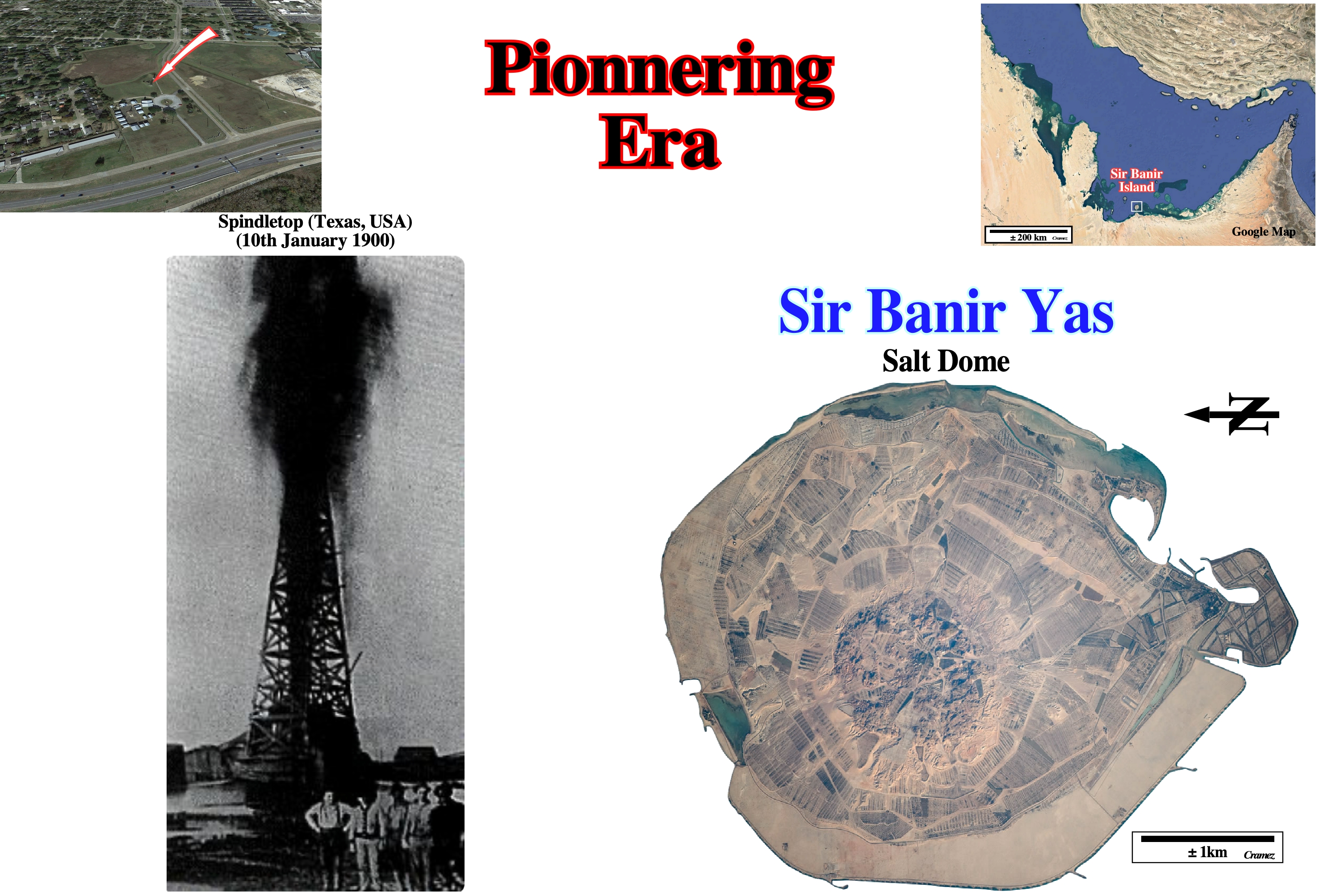
Salt outcrops were known since longtime, particularly near the Afar triple point, in association with subaerial volcanic rocks reason why in the pioneering Era geoscientist advanced igneous geological models to explain salt diapirism. Salt domes were almost unknown until an exploratory oil well was drilled (1900) on a low hill with a relief of about 10 meters, in which sulfur springs and natural gas seep occurred, the Spindletop Hill near Beaumont, Texas and completed in 1901. At a depth of about 300 meters, the well penetrated a pressurized oil reservoir that blew the drilling tools out of the well and showered the surrounding land with crude oil until the well could be brought under control (initial production from the well was over 100,000 barrels of crude oil per day). The Spindletop discovery ignited drilling on similar structures across the Gulf Coast area and the worldwide mapping and the study of salt domatic structures as the one illustrated above (Sir Bani Yas Island in the Persian Gulf on the western coast of the United Arab Emirates). In fact, the island is a mound pushed up by a rising salt dome that has broken through the surface of the island (the round core of the dome can be seen in the center of the island) (https://geology.com/stories/13/salt-domes/).
Plagioclase (McNeill, L. et al., 1999)
A group of triclinic feldspars of general formula: (Na,Ca)[Al(Si,Al)Si2O8]. At high temperatures it forms a complete solid-solution series from Ab Na[AlSi3O8] to An Ca[Al2Si2O8].
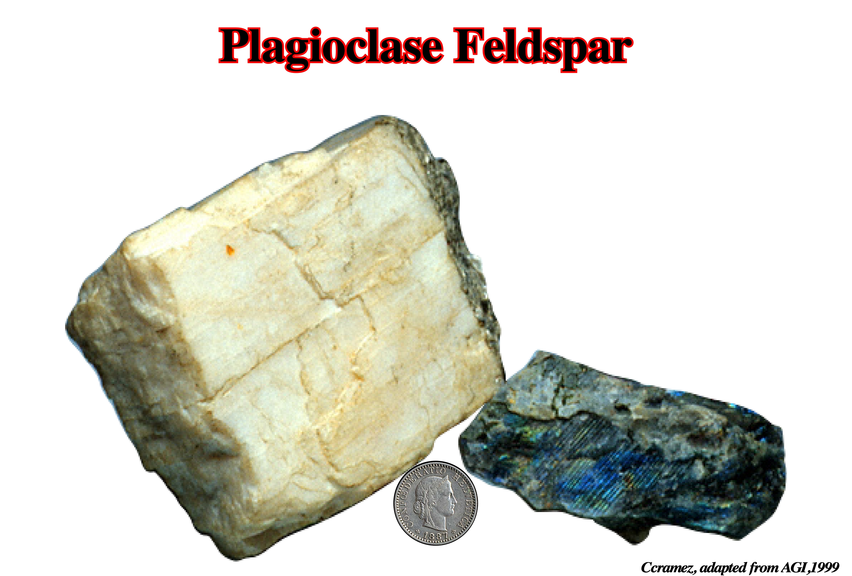
The plagioclase series is, arbitrarily, subdivided and named according to increasing mole fraction of the An component: albite (An 0-10), oligoclase (An 10-30), andesine (An 30-50), labradorite (An 50-70), and anorthite (An 90-100). The Al/Si ratio ranges with increasing An content from 1:3 to 1:1. Plagioclase minerals have characteristic twinning and commonly display zoning.
Platform
A flat or gently sloping underwater erosional surface extending seaward or lakeward from the shore. Synonym of shelf. In geomorphology, a platform is a general term for any level or nearly level surface, as a terrace or bench. In tectonics, the platform is the part of a continent that is covered by flat-lying or gently tilted strata, mainly sedimentary, which are underlain at varying depths by a basement of rocks that were consolidated during earlier deformations.
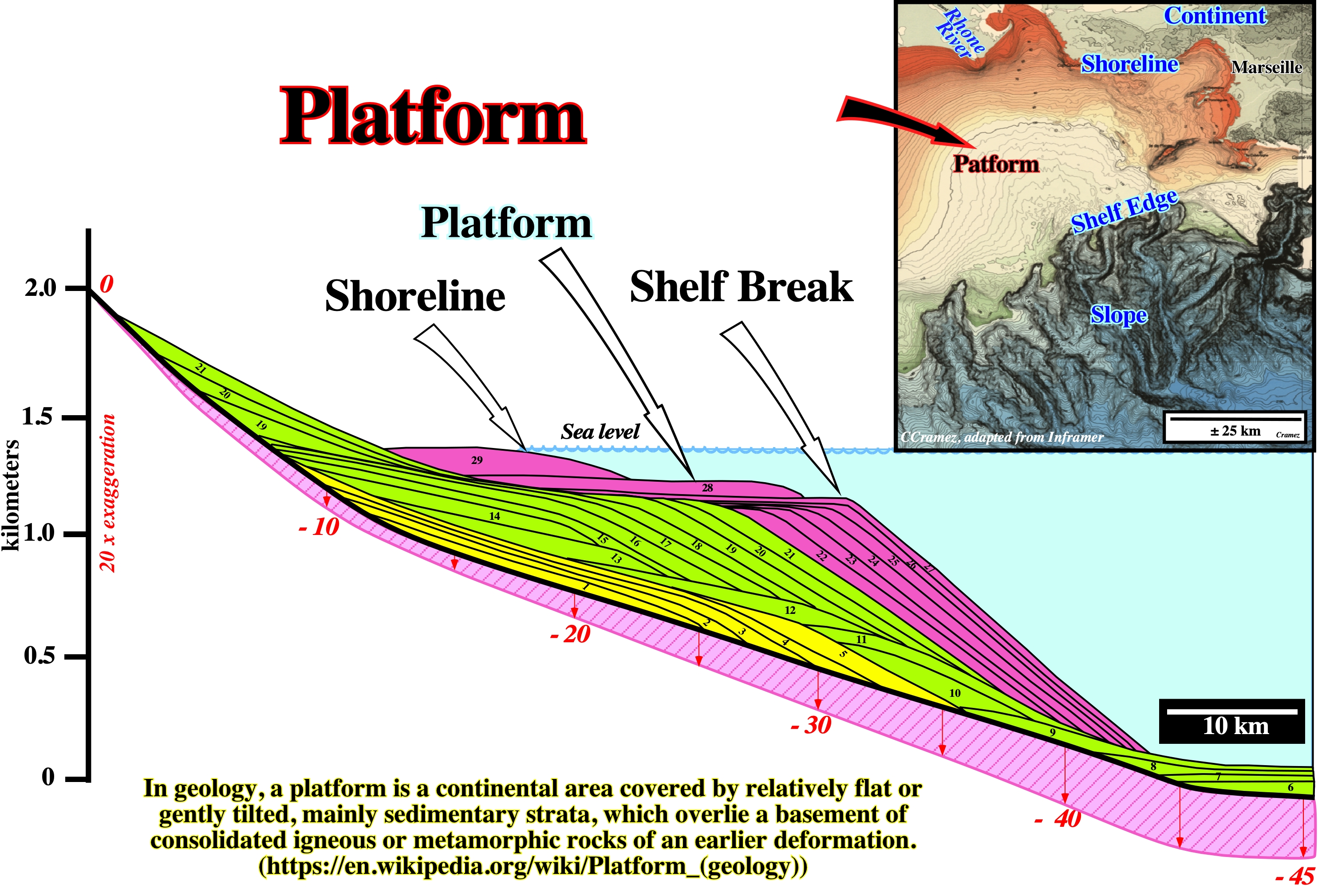
In Stratigraphy, the platform is limited between the shoreline and the shelf break. Generally, the water depth of a platform is under 200 meters. A platform is always present during transgressive episodes. On the contrary, during mature regressive episodes, when the shoreline coincides with the shelf break, the basin has not platform (no shelf).
Plug (Salt)
See: Salt Stock.
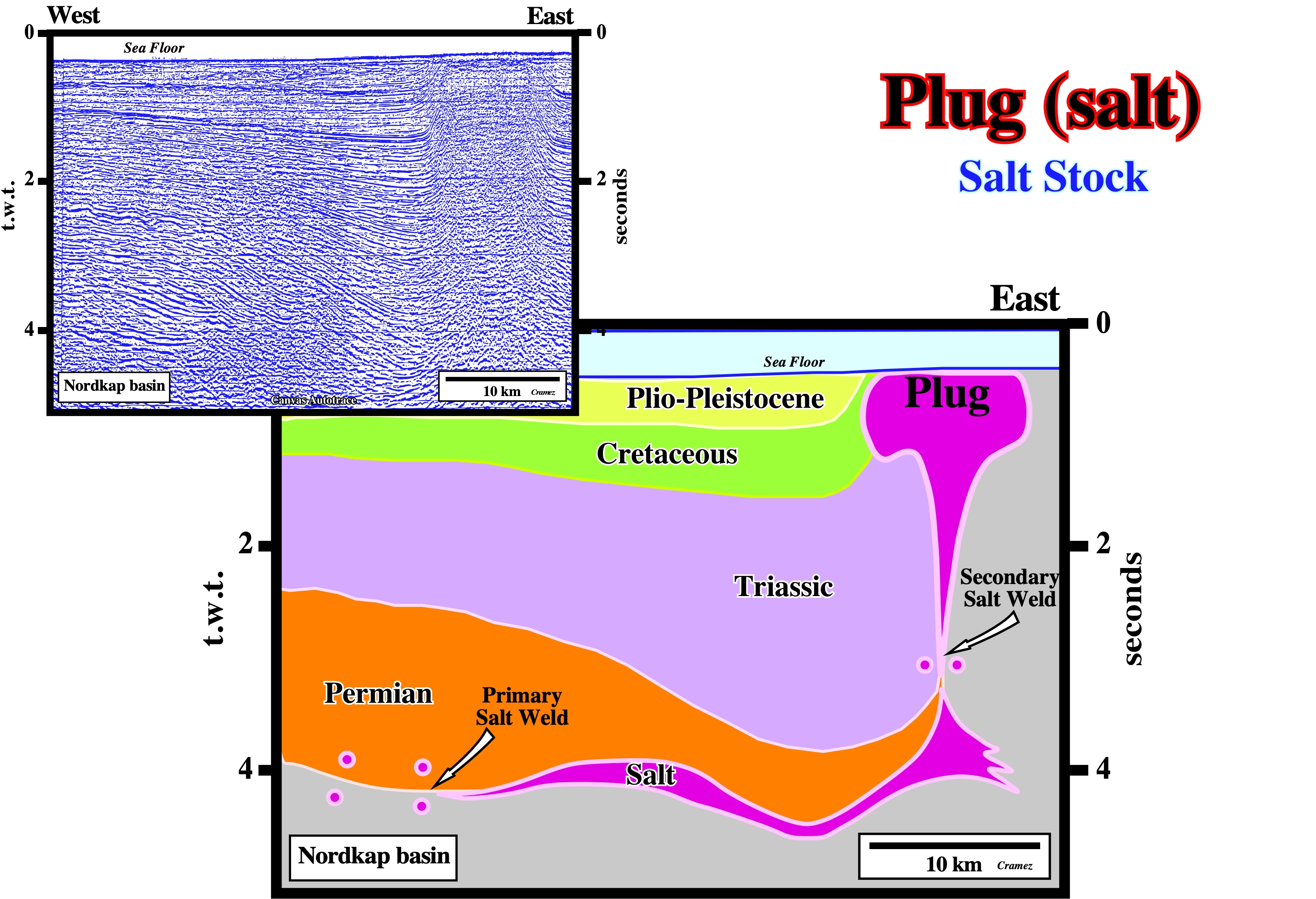
In Nordkap geographic basin, the majority of the Permo-Triassic salt structures show a post-dome geometry, which in conventional seismic lines, can only be picked using an hypothetical-deductive interpretation approach. Salt plug structures, as the one illustrated on this tentative geological interpretation of a Canvas autotrace, are difficult to refute. It is evident that below the salt plug the tentative interpretation is speculative and must be tested by new seismic data.
Polyhalite
A mineral: K2MgCA2(SO4)4 2H20. It is often brick-red owing to iron oxide. Polyhalite is an evaporite mineral (dissolved in water), a hydrated sulfate of potassium, calcium and magnesium. Polyhalite crystallizes in the triclinic system although crystals are very rare. The normal habit is massive to fibrous. It is typically colourless, white to gray, although it may be brick red due to iron oxide inclusions. It has a Mohs hardness of 3.5 and a specific gravity of 2.8.
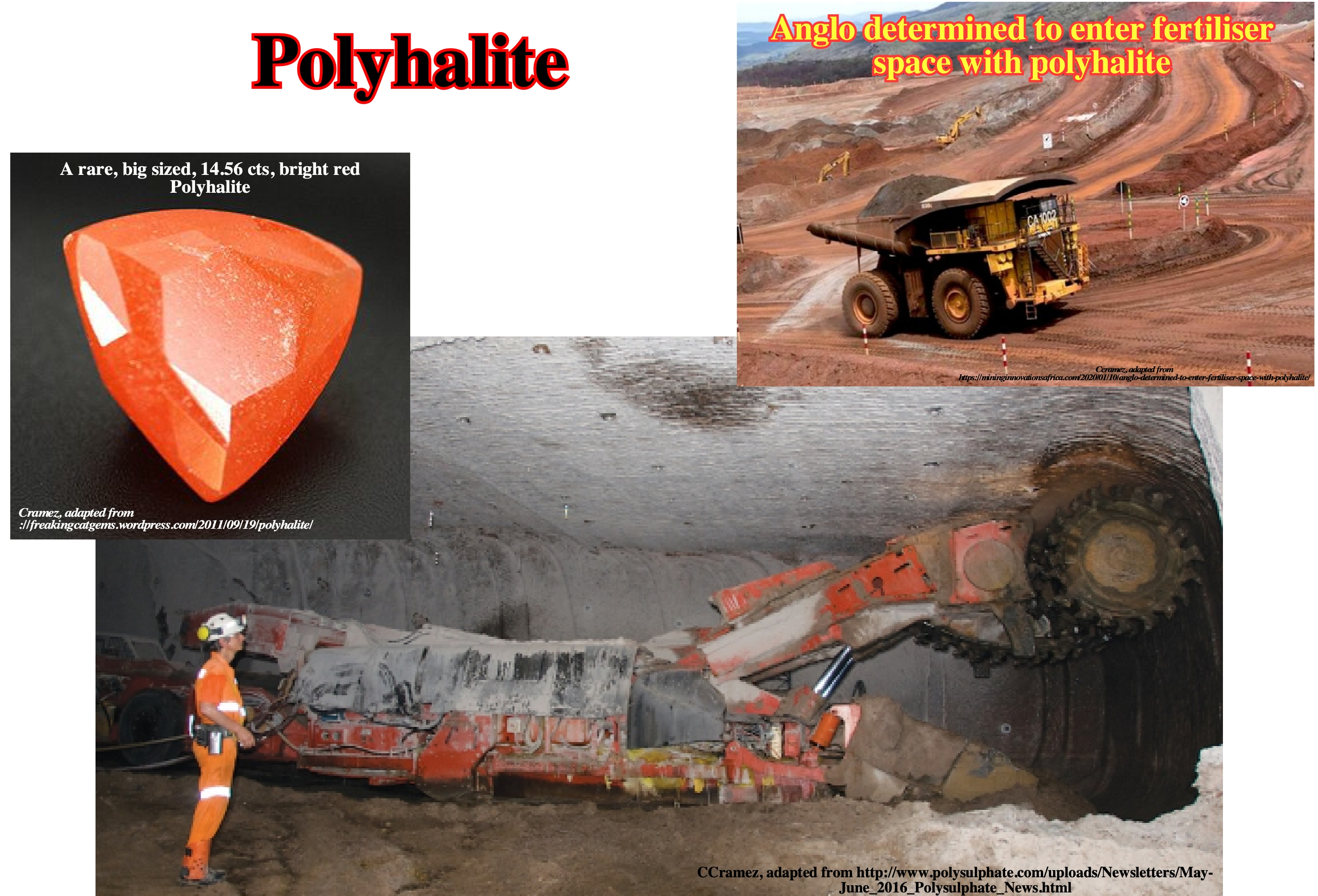
Polyhalite is a natural fertilizer bringing high performance nutrition and better crop health and yields in the fields on the earth’s surface. In North Sea, it is found around 1,200 meters depth. It was deposited around 260 million years ago during the Permian age. In Permian times, Europe was much further south. The place now known as Boulby was then on the edge of a broad, shallow ocean called the Zechstein Sea. The prevailing hot and dry conditions at that time meant the sea evaporated quicker than it could be re-filled, leaving behind polyhalite. Hence polyhalite is known as an evaporate mineral: a hydrated sulphate of potassium, calcium and magnesium with a formula: K2Ca2Mg(SO4)4·2H2O. Polyhalite was first discovered and described by Friedrich Stromeyer in Salzburg, Austria in 1818. Polyhalite is derived from the Greek: ‘poly’ meaning ‘many’, and ‘halite’ meaning ‘salt'. (http://www.polysulphate.com/uploads/Newsletters/May-June_2016_Polysulphate_News.html).
Pop-up Structure
Compressional structure developed when folding is not enough to solve volume problems. In areas where salt layers are affected by compressional tectonic regimes, when folding is not enough to shortened the overburden, additional shortening (pop-up structures) is developed in the crest of anticline structures to accommodate the sediments to new volume conditions.
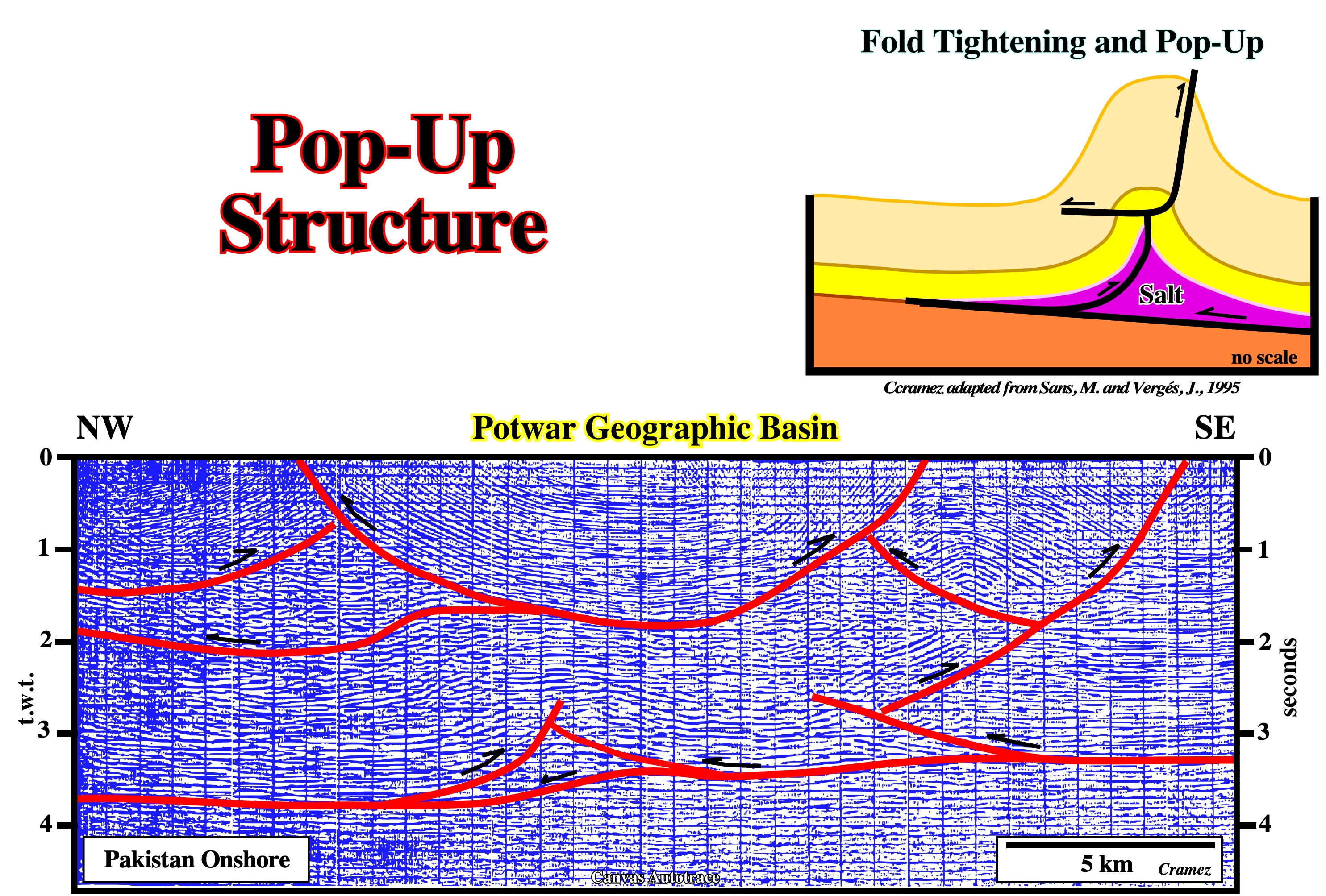
Pop-up structures associated with salt anticlines (Eocene Cardona salt, in the above tectonic geological sketch) have been described in southeastern Pyrenean thrust front. In fact in this area, the tightening of fold anticlines and blocking of thrusts promote the formation of pop-up structures in the anticline crest. On this tentative geological interpretation of a Canvas autotrace of a Pakistan onshore seismic line pop-up structures seem quite obvious. Some of them, particularly the lower ones seem to be associated with a salt layer, as it is the case in Melville Island (Canada).
Pore Pressure
The pressure of the interstitial fluids. In geology, the fluids, generally, water, saturating the open pore spaces of a rock column have the same effect as immersing a rock in a water column. The pore pressure (σp) is given by: (σp) = d’ . g . h
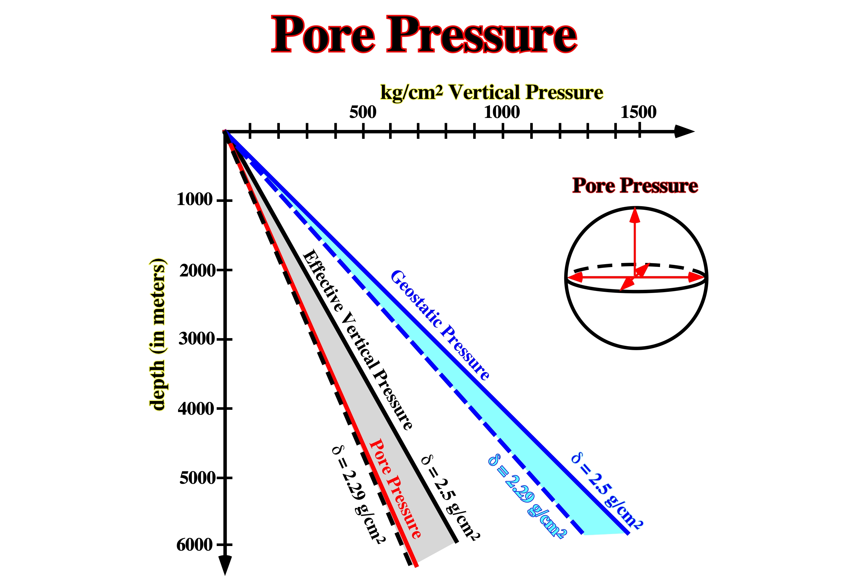
A significant increasing in pore pressure, which acts in opposite sense of the geostatic pressure, creates conditions to gravity deformations.
Post-Salt Dome Stage
Stage when a salt dome becomes disconnected from the mother salt layer, thereof it cannot grow anymore.
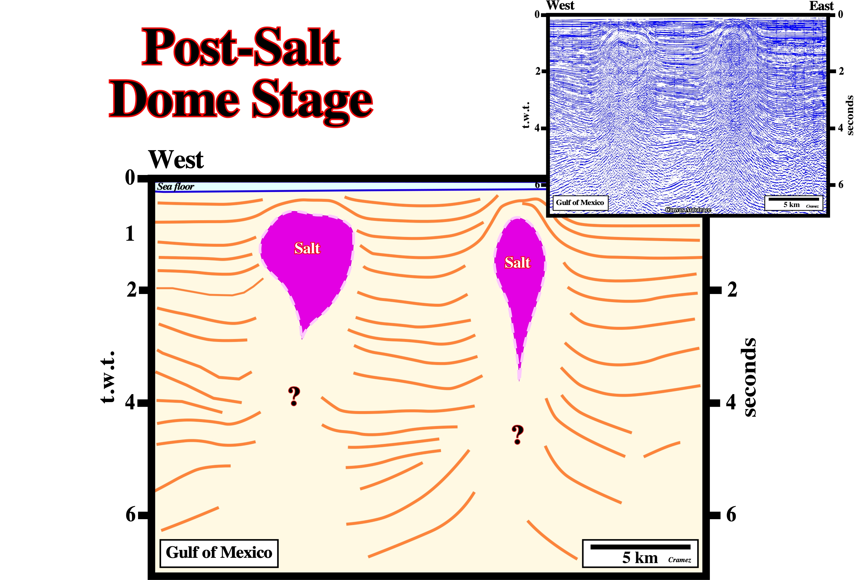
On this preliminary tentative interpretation of a Canvas autotrace of a GOM seismic line , several tectonic disharmonies can be recognized. The post-dome salt structures can be associated with an allochthonous or an autochthonous salt layer. An association with the autochthonous salt seems more likely.
Postkinematic Layer
Strata interval overlying the synkinematic layer and recording sedimentation after salt flow or any other deformation has ceased. Basal postkinematic strata can onlap or truncate an underlying, uneven, deformed surface but show no thickness changes ascribed to local deformation.
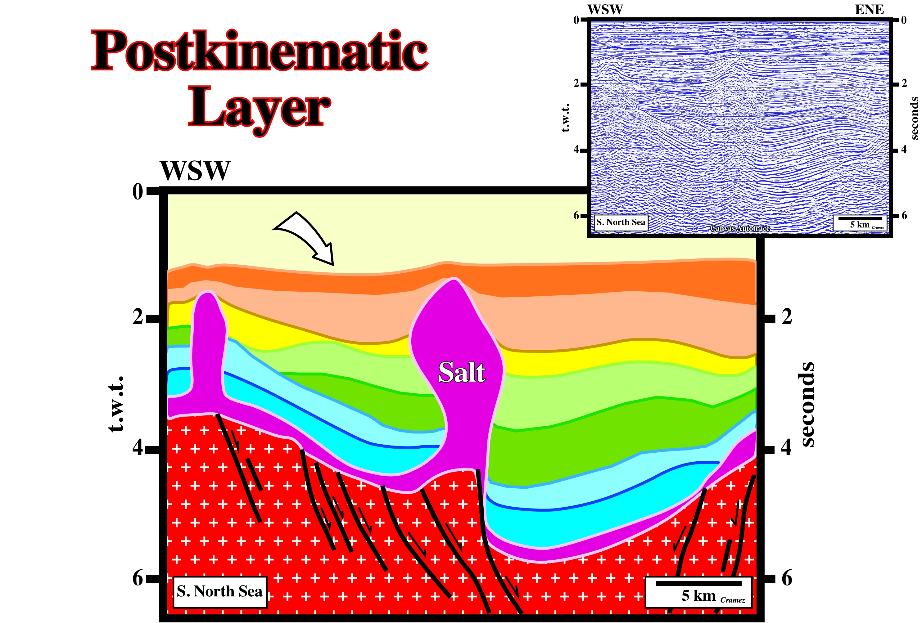
A more or less constant thickness is a major characteristic of a postkinematic layer. On this tentative interpretation of a Canvas autotrace, the progradational internal configuration slightly mask the isopachous of the postkinematic layer.
Potash Evaporites
Evaporites rich in potash are much more diagnostic of brine source than are halite deposits. Potash evaporites form two groups. (i) A rare group rich in MgSO4 forms by evaporation of seawater originating from rivers. The sulfate mineral, polyhalite, kainite, and kieserite, are diagnostic. They are known in the Vendian, Late Mississippian to Permian, and Miocene to Quaternary. (ii) The second, more common, group is rich in KCl and CaCl2 poor in Mg SO4. This group cannot form by evaporation of seawater from rivers alone. The chloride minerals, sylvite, carnalite, tachyhydrite, and bischofite are diagnostic. This group formed in the Cambrian through Early Mississippian and Jurassic through Paleogene. These KCl minerals originate from brines enriched in CaCl2 by hydrothermal water rock interaction.
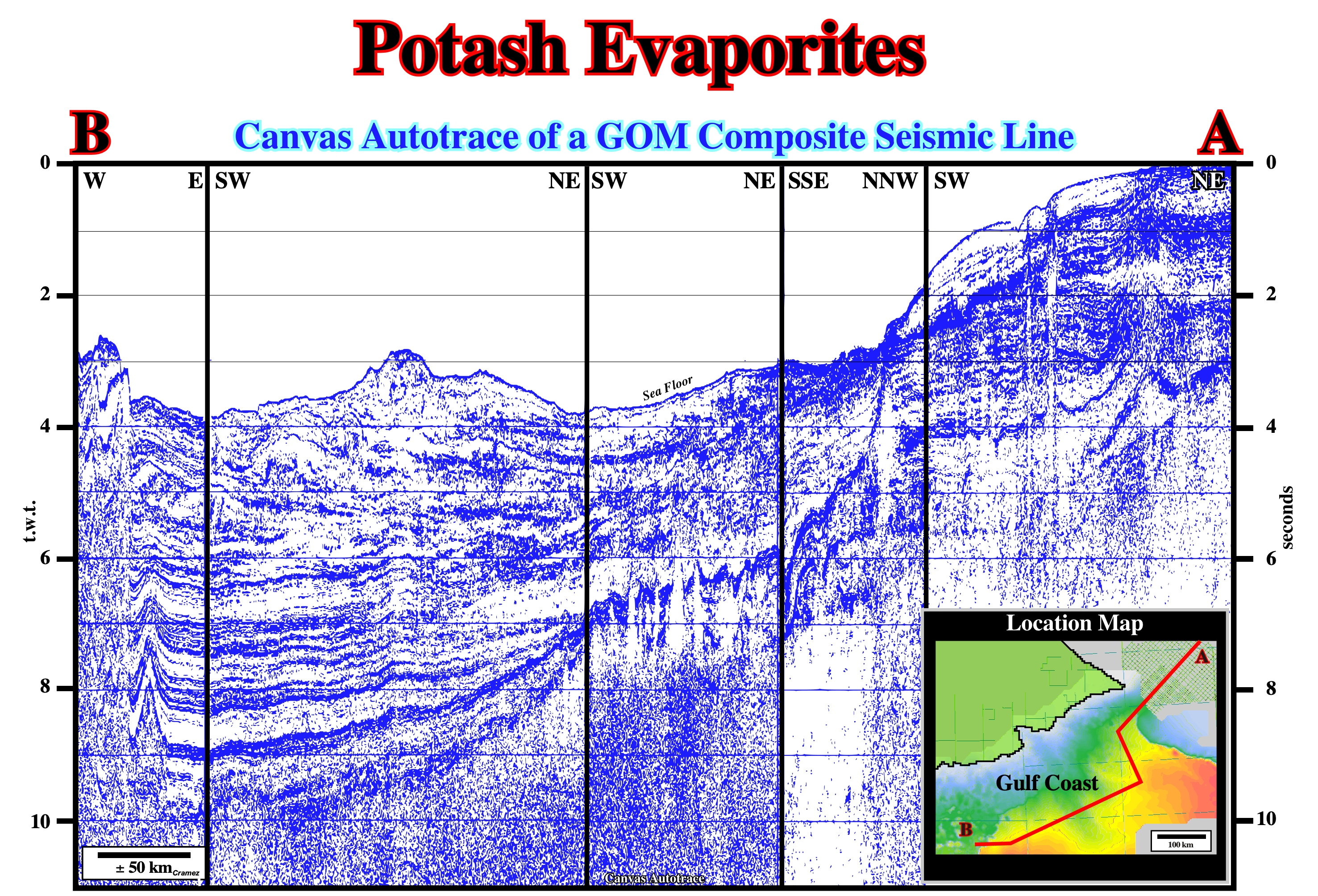
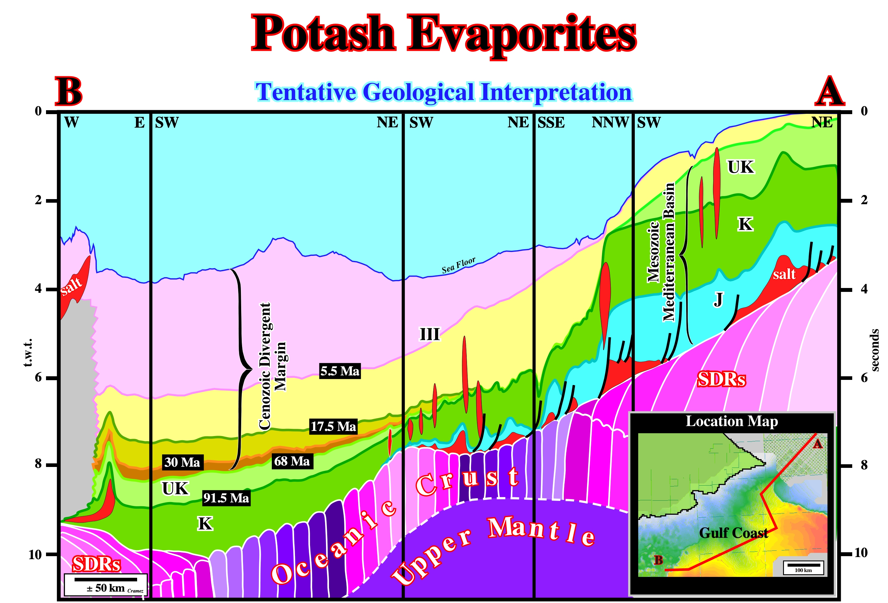
The association between the allochthonous salt interval and the subaerial volcanic crust ("Seaward Dipping Reflectors, i.e., SDRs) recognized on this tentative interpretation of a Canvas autotrace of a composite GOM seismic line , which is, equally, visible in Angola, Congo and Brazil offshores, can be invoked to explain the chemical composition of the salt found not only in Gulf of Mexico (Mesozoic Mediterranean Basin), as in South Atlantic Offshores (Continental Divergent Margins). The salt is rich in sylvite, carnalite, tachyhydrite and bischofite, which strongly suggests the salt brines were enriched in potash due to the spilitisation of the basalt composing the subaerial volcanic crust (SDRs).
Precambrian
A unit of the Standard Global Chronostratigraphic Scale comprising all the rocks formed before the beginning of the Paleozoic Erathem.
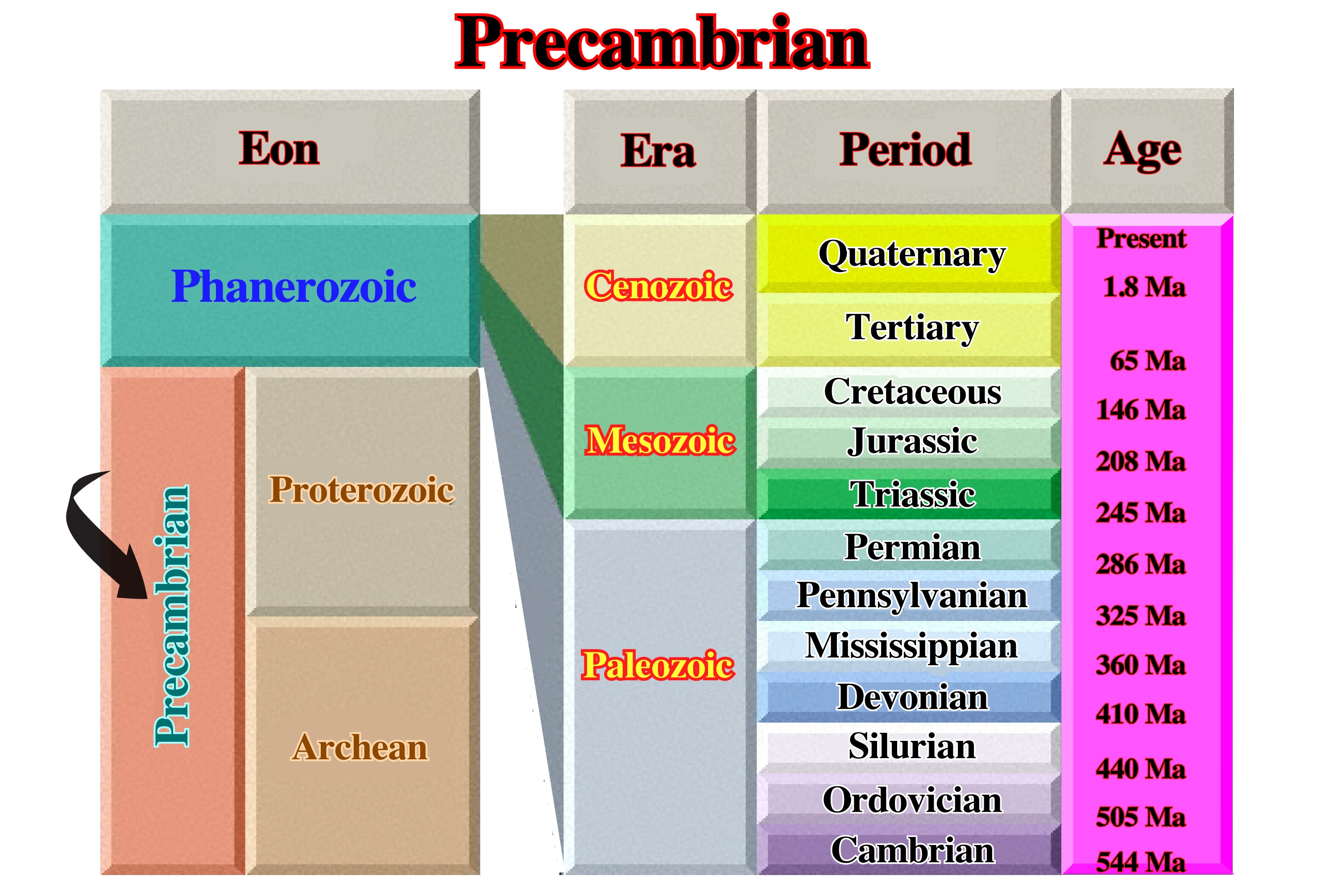
The Precambrian is also the time during which Precambrian rocks were formed. It is equivalent to about 90% of geologic time. Precambrian time has been divided according to several different schemes.
Precambrian Salt Deposits
Precambrian halogenic rocks have been recognized in many areas of Eurasia, North America, Africa and Australia. Asa rule, they are represented by gypsum and anhydrite. Salt beds of more or less confirmed Precambrian age are known only from Australia in Amadeus basin. They have been suggested as occurring also in the Officer Basin.
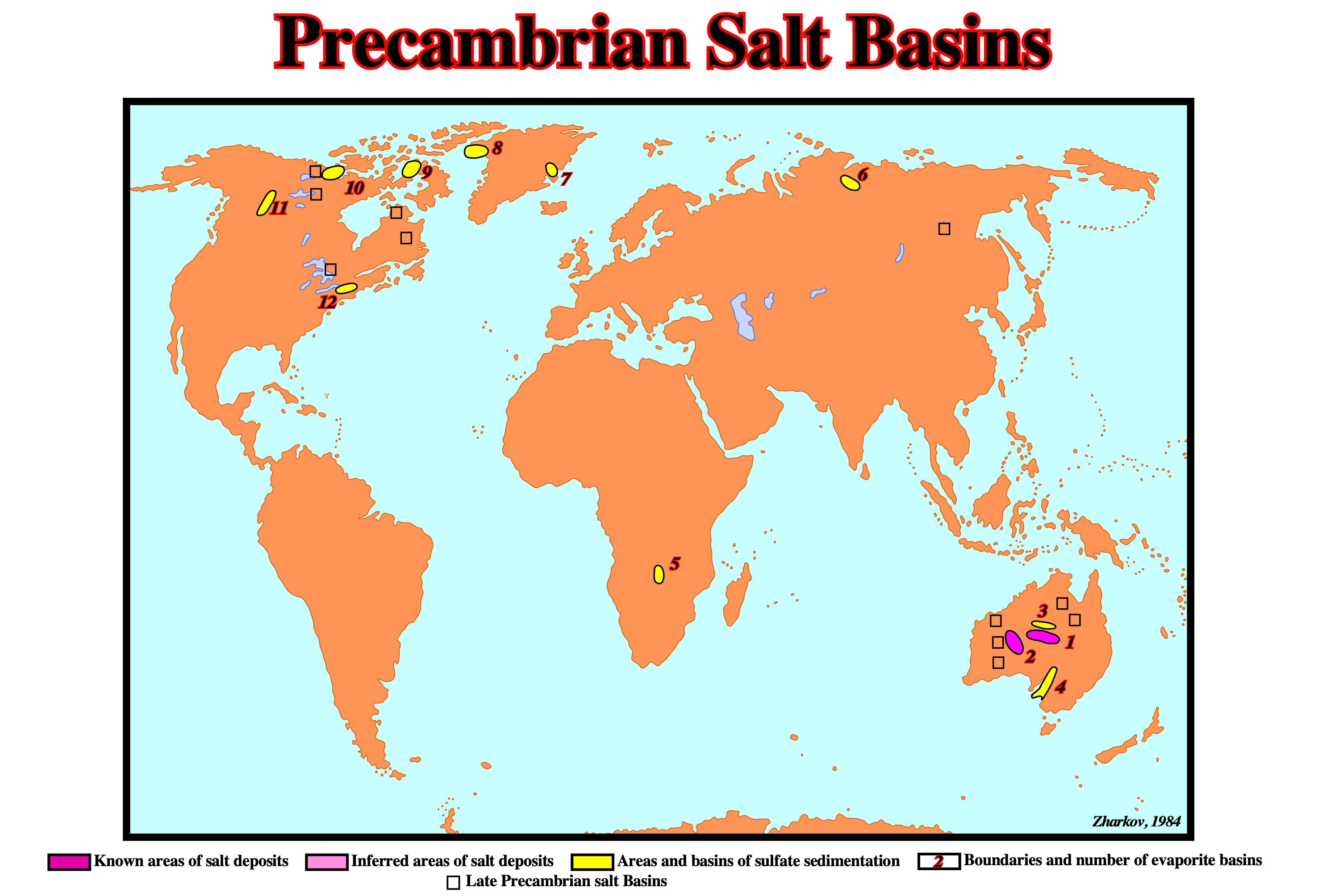
The distribution of Precambrian evaporite deposits can be summarized as follows: (1) Amadeus , (2) Officer , (3) Ngalia basin ; (4) Adelaide Geosyncline ; (5) Mufulira Syncline ; (6) Kotuikan basin ; (7)Merkebjerg Basin ; (8) Thule Basin ; (9) Borden Basin ; (10) Amundsen Basin ; (11) Mackenzie Hills ; (12) NW Adirondack Mountains.
Prekinematic Layer
Strata interval whose initial stratigraphic thickness is constant (or no more variable than is typical for the region) above a salt structure or its adjacent rim syncline (below any synkinematic layer). The prekinematic layer records sedimentation before salt movement or any other deformation began.
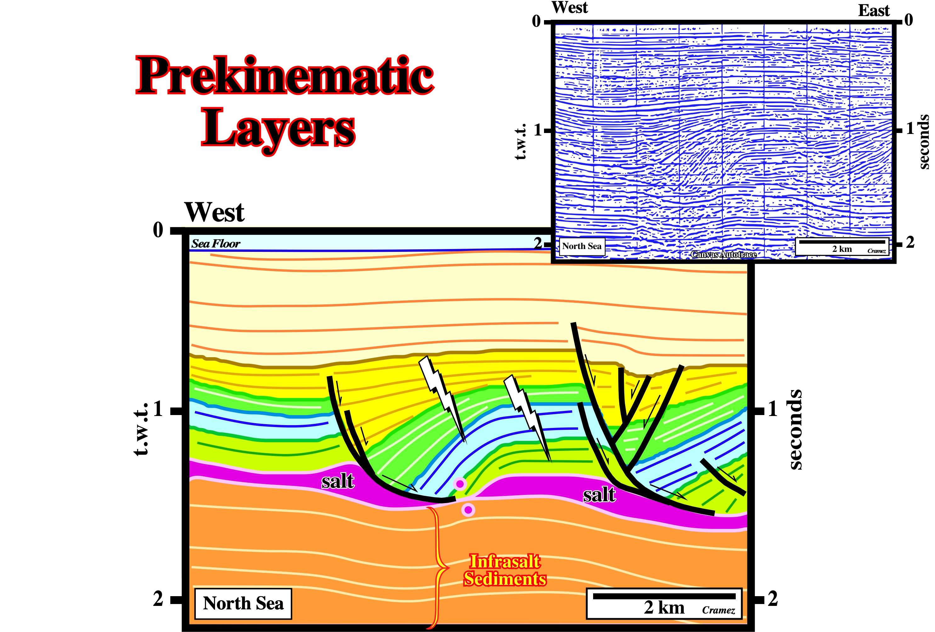
As the intervals just above the salt layer (light green and blue) are isopachous, they can be considered as prekinematic, i.e., anterior to the salt flowage. On this interpretation, the rotation of the downthrown blocks (rollovers), as well as the thickening of the sedimentary packages toward the faults looking eastward are coherent with the decreasing hade of the fault planes. Such a rotation creates a tectonic disharmony at the top of the salt (when the salt is present), which is characterized by downlap seismic surface. This geometry implies an arcuate cartography of the fault plane. A smaller fault weld can recognized at the toe of the first growth-fault. Along the other growth-fault (on the right) several accommodation faults were developed to solve the volume problem created partially by the extension and partially by the salt flowage. According to the Goguel’s law, during deformation the volume of the sediments must be constant. In spite of the fact that this law is approximate law (lost of volume by compaction of the sediments and salt dissolution), it can be considered as an application to Geology of the first law of thermodynamics or law of conservation of energy. The pull-ups and pull-downs at the top of the subsalt strata emphasize lateral velocity variations on the cover (salt + overburden).
PREP Method (Worrall, D.M. and Snelson, S.,1989)
Reconstruction technique to restore syndepositional faulting. This technique preserves area, accounts for decompaction and minimizes the shape change within fault blocks. The horizontal component of unfaulted bed length is preserved and footwalls are not assumed to be rigid.
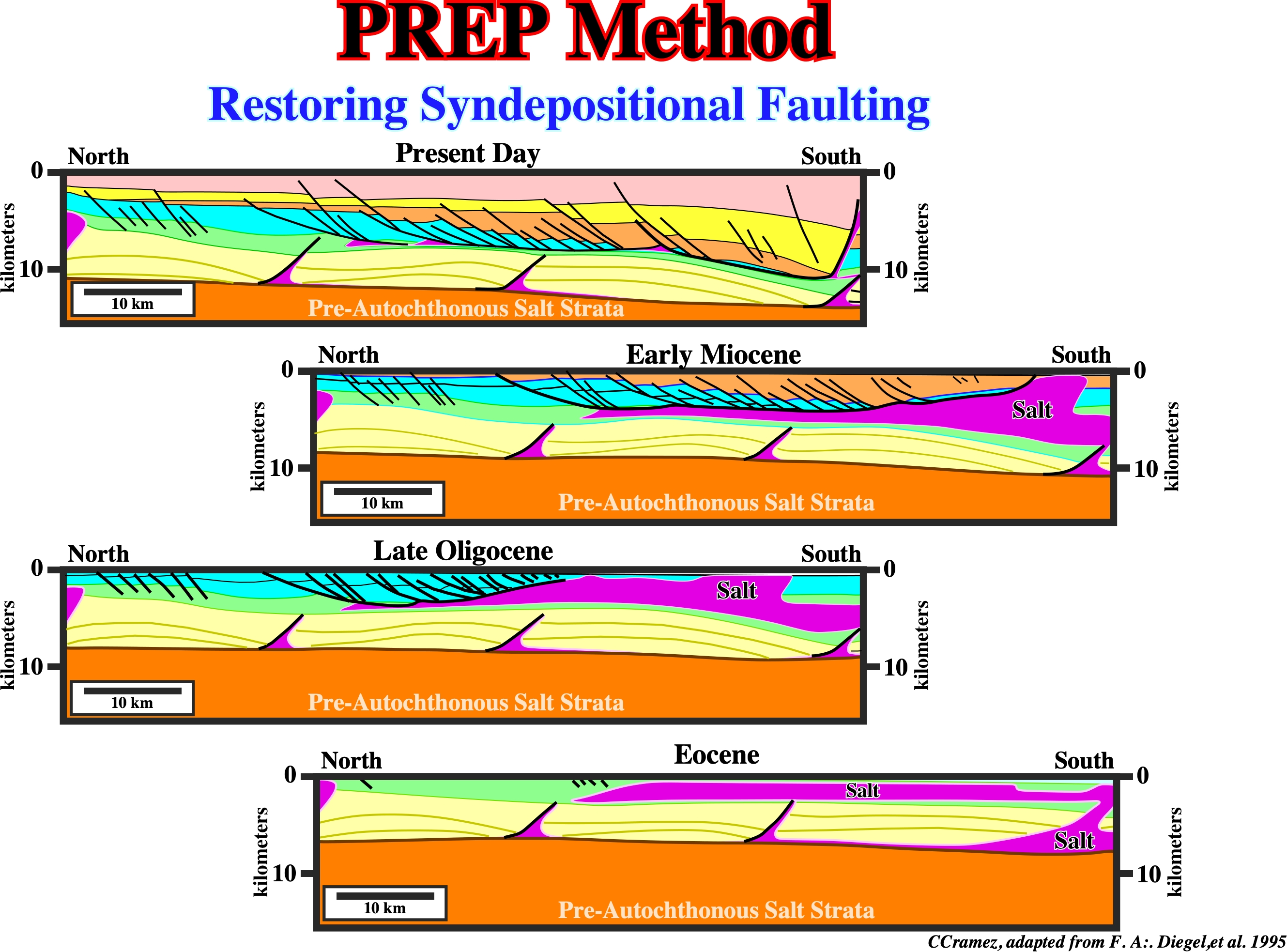
Two reconstruction techniques were used to restore syndepositional faulting in this study. The proprietary PREP computer program described by Worrall and Snelson (1989) and a proprietary finite-element program called MESH (Diegel and Cook, 1990). This finite-element technique preserves area, accounts for decompaction, and minimizes the shape change within fault blocks. The horizontal component of unfaulted bed length is preserved, and footwalls are not assumed to be rigid. The method used for each reconstruction is noted in the captions. Paleobathymetric slopes are assumed to be constant through time with respect to the position of the prograding shelf margin, with a maximum slope of 1.5 degrees. Because of the probability of three-dimensional flow and dissolution, salt area is not preserved. Instead, salt thicknesses through time are estimated from a one-dimensional isostatic calculation described below and by Diegel and Cook (1990). On the isostatically balanced reconstruction illustrated above two-stages of evolution were assumed: (i) Extrusion of salt into a canopy near the sea floor at Eocene -Oligocene time and (ii) allochthonous salt evacuation by prograding Miocene depocenters producing a salt weld. The counter regional faults below the detachment were interpreted as collapse salt bodies that acted as feeders during the salt emplacement. The reconstruction above detachment was done by the PREP method. (Diegel et al., 1995).
Pre-Raft
An early stage of extension during which the fault block still rests on its original footwall.
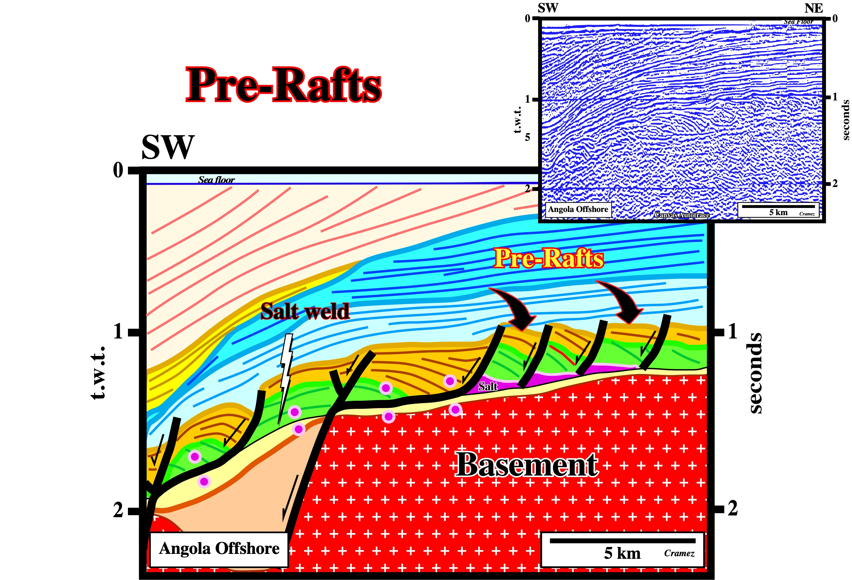
As the pre-raft structures still rest on its footwalls, the potential petroleum system in a pre-raft domain is quite different of the raft domain. The generating petroleum system is the same, but the entrapment migration subsystems are quite different. The chances of find large accumulations in a pre-raft domain are smaller than in a raft-domain, as depicted on this interpretation.
Pressure
The force exerted across a real or imaginary surface divided by the area of that surface, or the force per unit area exerted on a surface by the medium contact with it. Pressure is often as an incorrectly used short form for lithostatic or geostatic pressure.
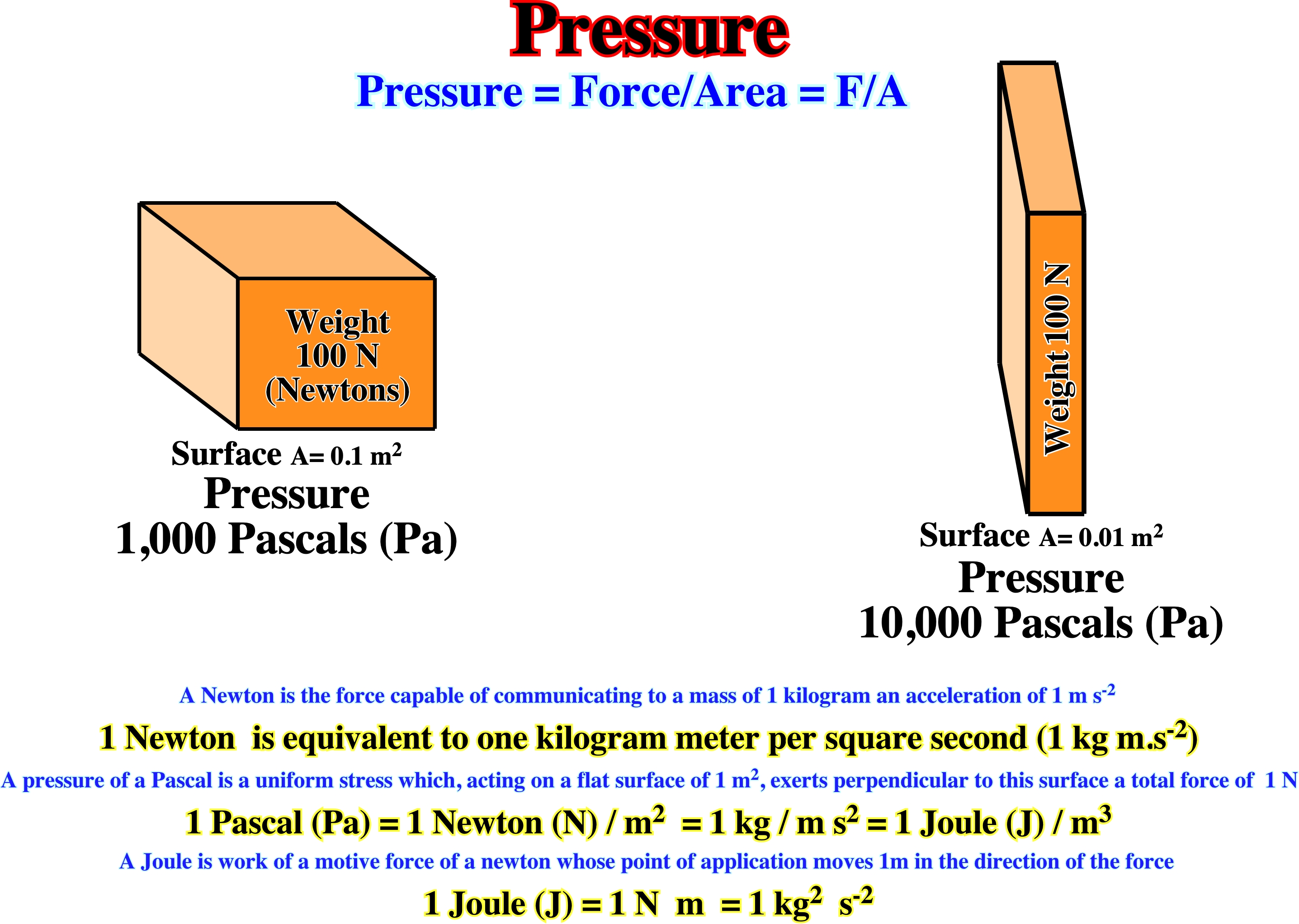
Same force, different area, different pressure. The pressure unit Pascal (Pa) is derived from the unit of the (weight) force Newton (N), i.e. N je m². One pascal (Pa) corresponds to the pressure acting evenly on a surface when a force of 1 N is exerted vertically on an area of 1 m². Pressure measurement compares an actual pressure with a reference pressure. Pressure measuring technology distinguishes between the following types of pressure, enabling a statement to be made about the relationship between the measuring pressure and the reference pressure. Absolute pressure relates to the vacuous space of the universe (zero pressure). Absolute pressure: (i) Measured pressure above absolute zero ; (ii) Reference, ideal vacuum ; (iii) Measuring pressure is always greater than reference pressure. Differential pressure : (i) Measured pressure above or below any desired reference pressure ; (ii) Measuring pressure is less or greater than reference pressure. (https://www.testo.com/en-TH/services/knowledgebase-pressure-physical-principles).
Primary Peripheral Sink
Peripheral sink, which accumulates on the flanks of a growing salt pillow and comprises strata that thin toward the salt structure.
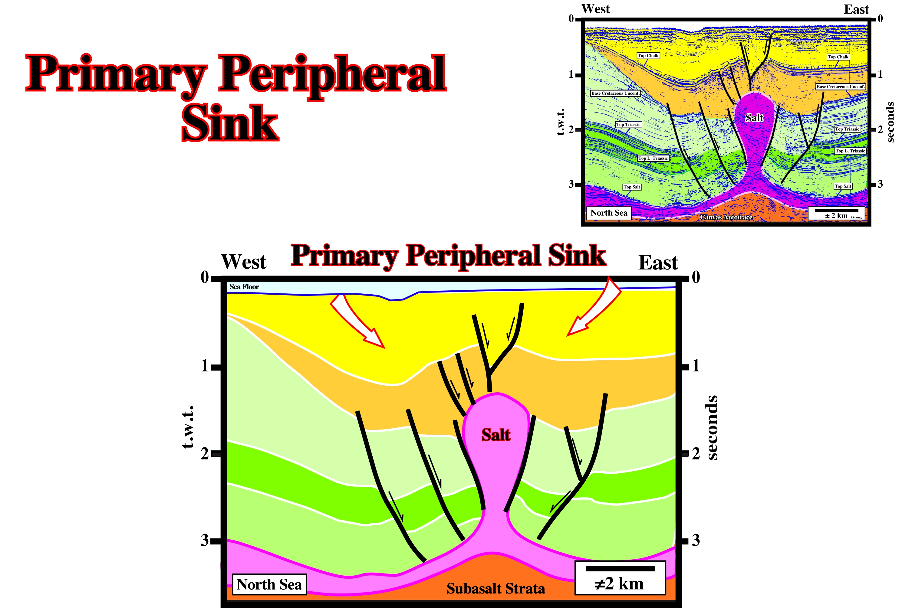
On this tentative interpretation of a Canvas autotrace, there is not evident peripheral sinks at least within the green intervals. The salt seems become active with an extensional tectonic regime, which lengthened the basal green interval. The brown interval is contemporaneous of such an extensional tectonic regime, which locally, increased the accommodation allowing the depocenters of the upper brown interval. Then, during the deposition of the yellow interval, the salt diapir becomes active, i.e., moves upward, creating primary peripheral sink around it in the yellow interval.
Primary Salt Weld
Salt weld joining strata originally separated, by gently dipping, autochthonous bedded salt.
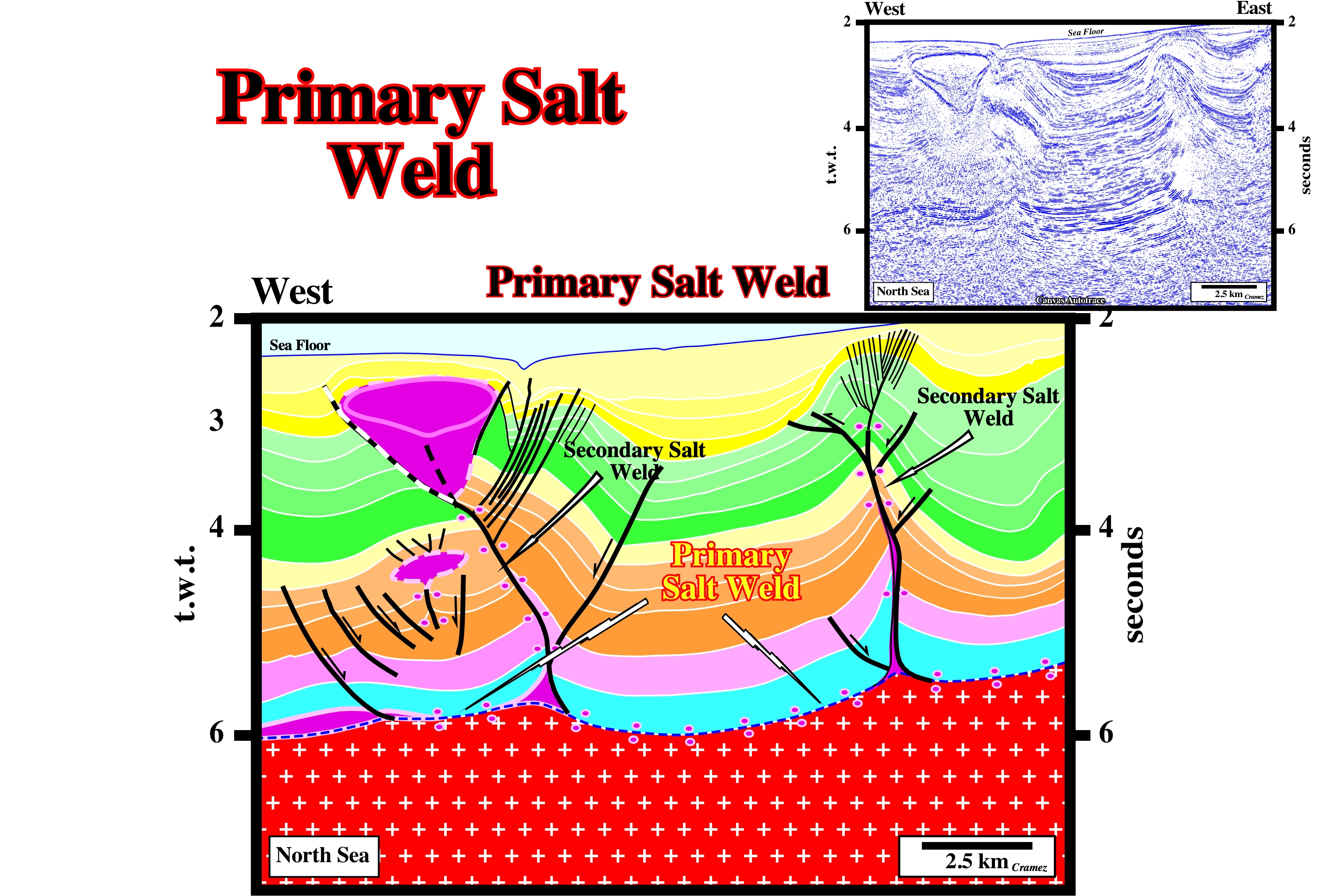
Primary sal welds are easy interpreted as induced by salt flowage when relics of the autochthonous salt layer are found laterally, as it is the case on this tentative interpretation of a Canvas autotrace.
Prodelta Environment
Environment located below the effective depth of wave erosion, lying beyond the delta front and sloping gently down to the floor of the basin in to which the deltaic environment is advancing and were clastic river sediments cease to be a significant part of the deposits, in other words, the facies is mainly shaly.
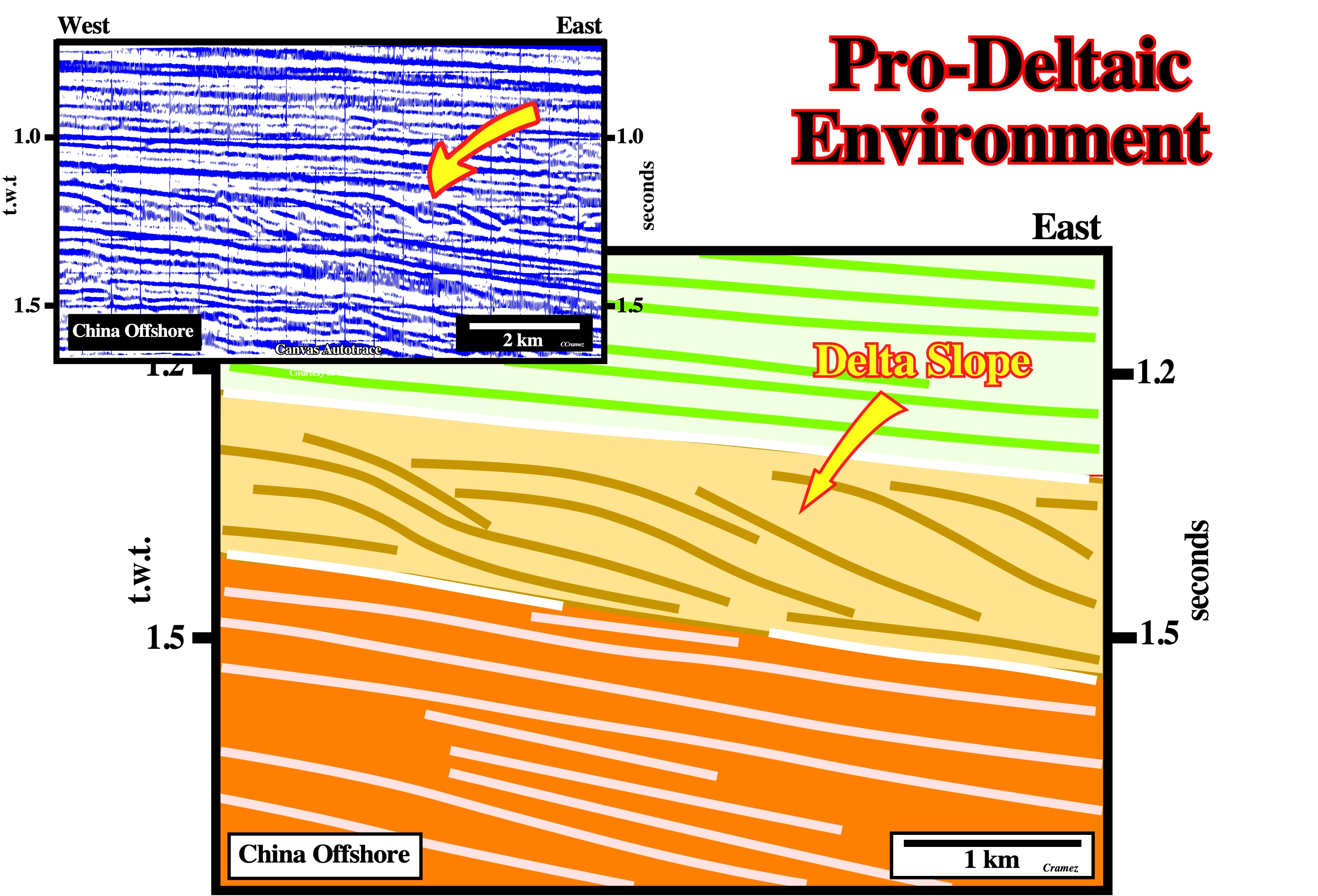
On Canvas autotrace of seismic lines, prodelta environments correspond to the delta progradations, i.e., seaward or lakeward progradations of the depositional coastal break. The thickness of a prodelta is, generally, smaller than 50 meters, which allows, easily to individualize a delta from a delta building, which thickness can reach several thousand meters.
Progradation
Seaward or lakeward displacement of depositional coastal breaks, which in a mature regressive interval (basin without platform, or no shelf) coincide with shelf breaks.
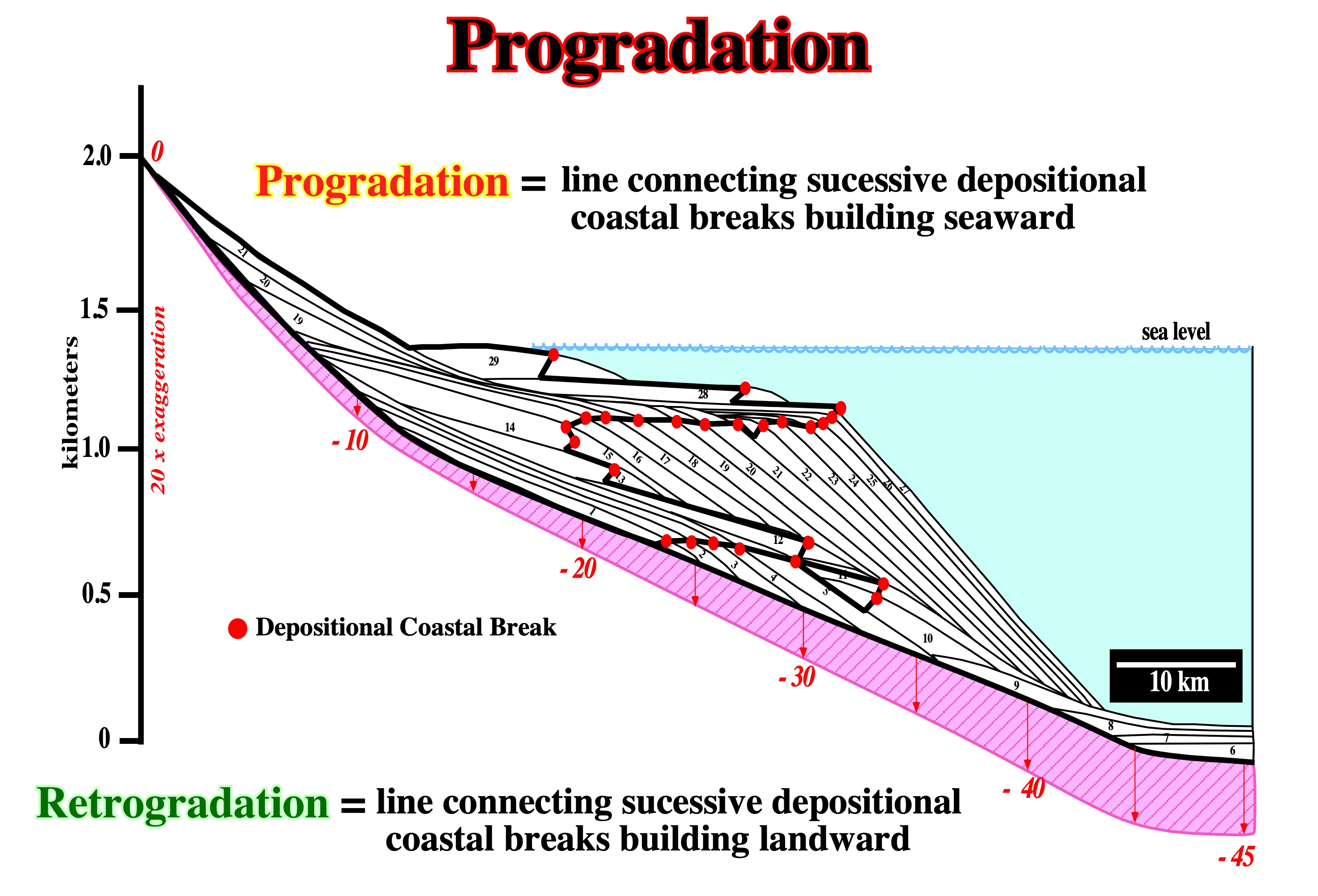
A seaward displacement of the depositional coastal break creates a forestepping geometry and characterizes a regressive episode. A landward displacement, i.e., a retrogradation creates a backstepping geometry and characterizes a transgressive episodes. Both correspond to relative sea level rises. During a progradation the relative sea level rises in deceleration, while during a retrogradation the sea level rises in acceleration.
Progradational Interval
Interval with an progradational internal configuration characterized whether by sigmoidal or oblique progradations what suggest a regressive sedimentary episode.
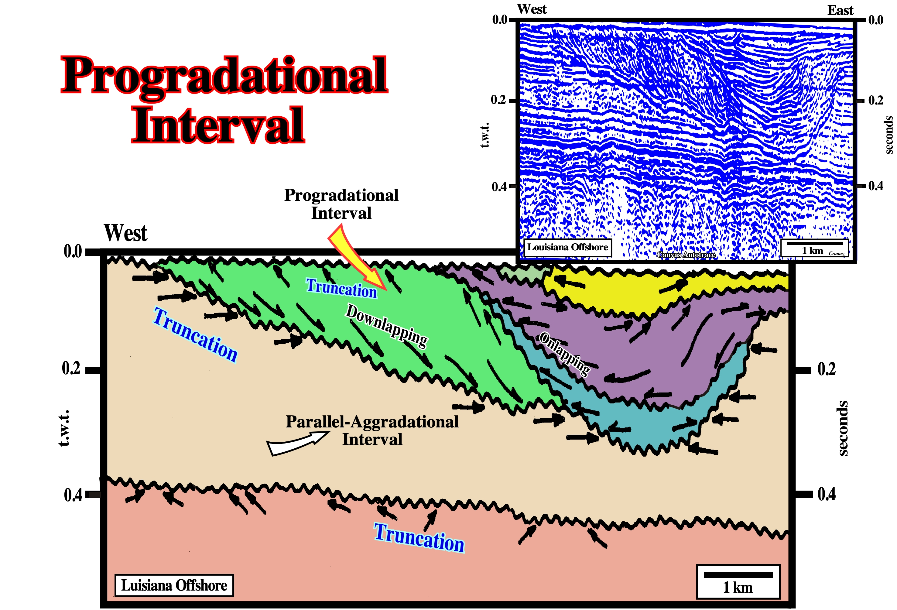
The progradational interval (coloured in green) associated with the point-bar (arrow) contrasts with the parallel-aggradational interval (coloured in beige) of the infrastructure, as well as, with the filling geometry of clay plug interval.
Pull-Apart Diapir (Ruig, M. J., 1995)
Diapirs bounded by strike-slip faults and with a typical rhomb-shaped geometry. Pull-apart diapirs have been interpreted to have intruded pull-apart basins. They are mainly described in southern part of the Prebetic Mountains.
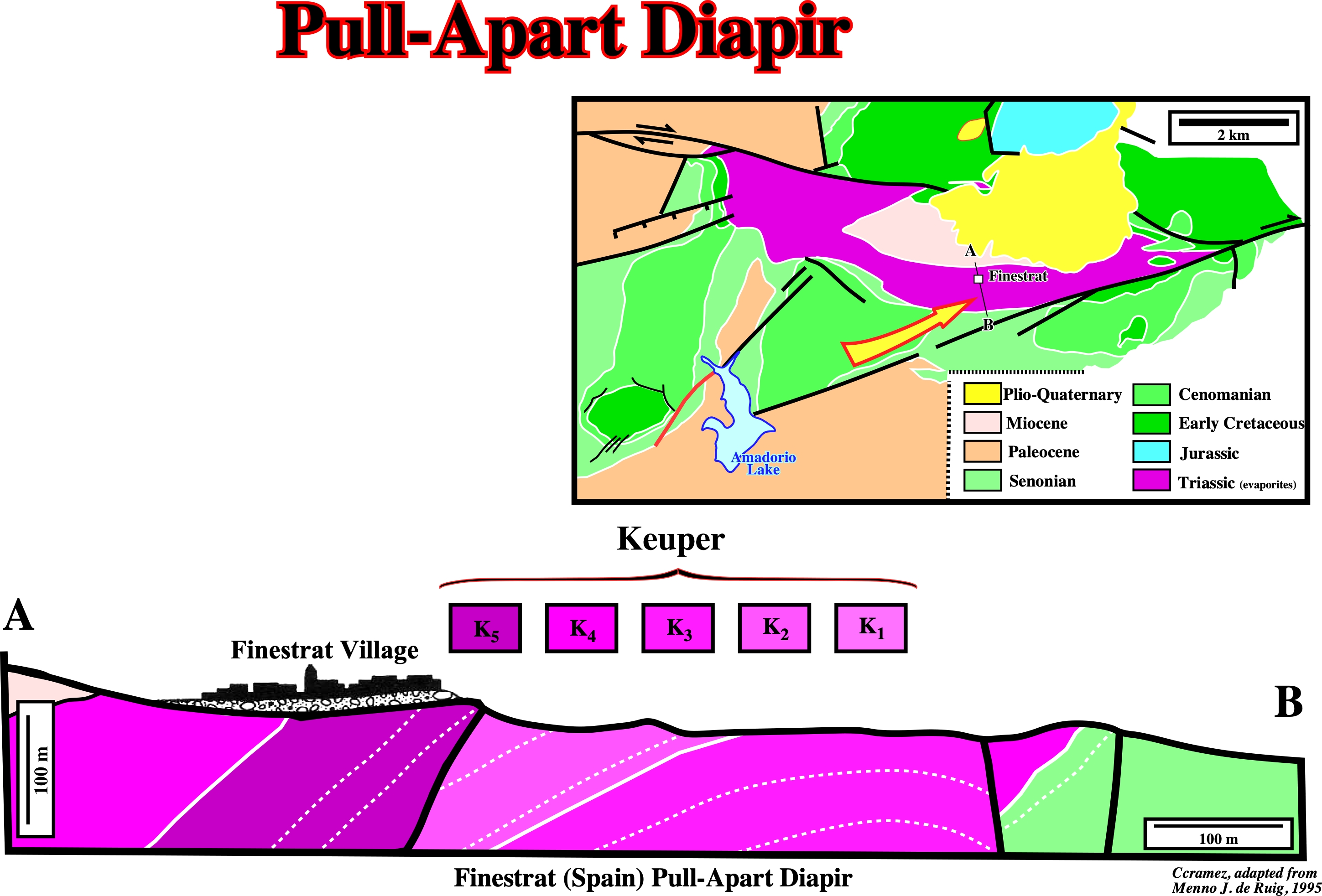
Geological map and cross section of the Finestrat diapir show: (i) The normal fault in adjacent overburden are, genetically, related with the diapir formation ; (ii) Overturned slabs of Triassic that according to de Ruig are remnants of mushroom folds ; (iii) The external shape of the diapir and its location between overlapping dextral strike-slip faults suggest it has intruded a pull-apart structure.