
Corrosion (Rocks)...............................................................................................................................................................................................................Corrosion
Corrosão / Corrosión / Korrosion / 腐蚀 / Коррозия (пород) / Corrosione /
Process of chemical dissolution of water in limestone and other carbonated rocks, such as dolomite, marble, calcareous marl, etc. This process is important for the karst formation and, especially, of caves and grotto.
See: « Karst »
&
« Limestone »
&
« Corrasion »
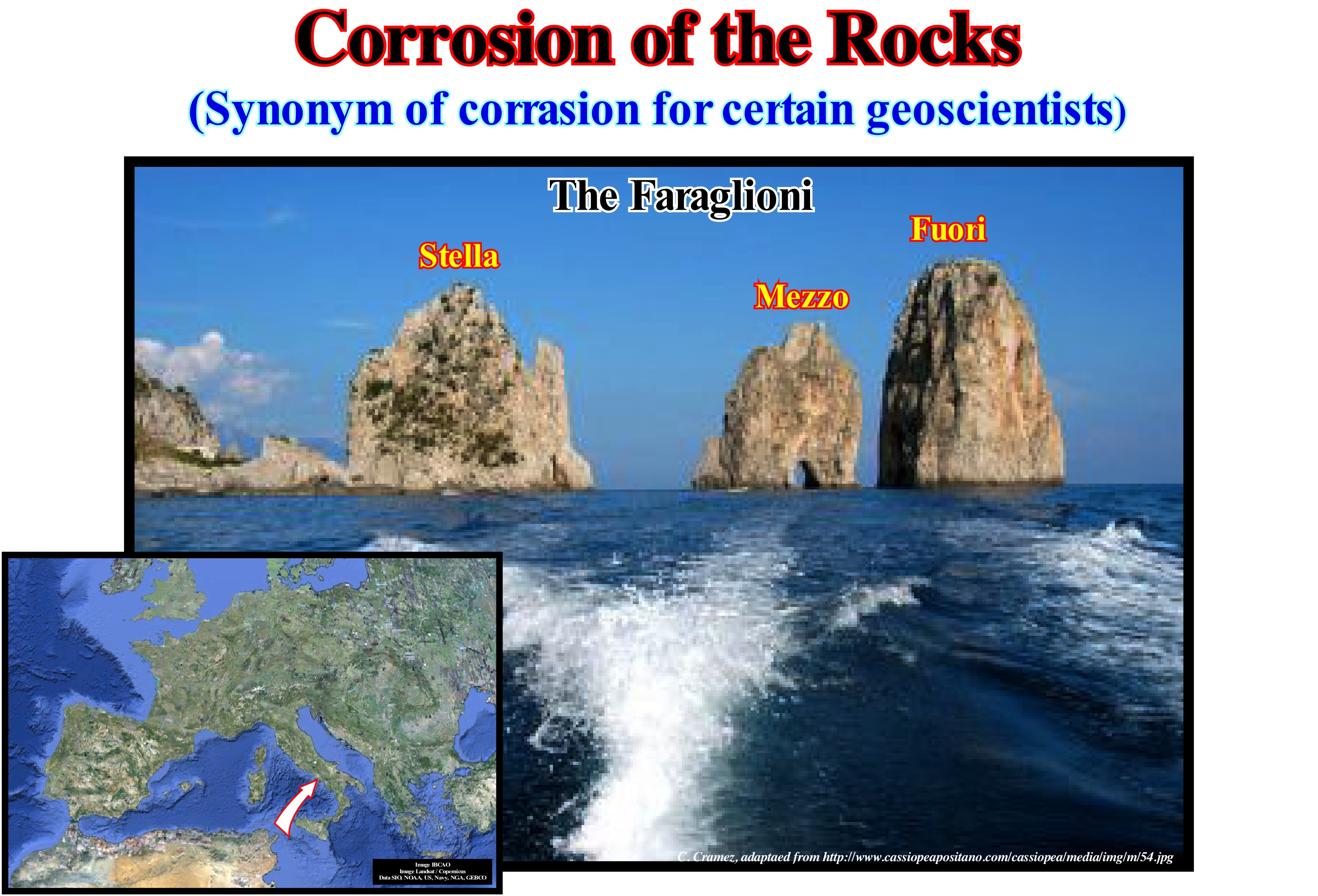
In general, corrosion means the change of a material by a chemical reaction with an oxidant (dioxygen, O2, which is the molecule composed of two oxygen atoms and the cation H+). Corrosion excludes purely mechanical effects (such as fracturing), but it can occur on certain types of wear surfaces, the causes of which are physiochemical and mechanical. The most well-known examples of corrosion are the chemical changes of metals in water, such as the oxidation of iron and steel or the formation of copper verdigris and copper alloy alloys (bronze, brass). Corrosion is a much broader process, covering all types of materials (metals, ceramics, polymers, etc.) in different environments (aqueous, atmosphere, high temperatures, etc.). As illustrated in this figure, a typical example of corrosion are the Faraglioni. This three rocky blocks of the Eastern Italian coast survived to coastal slides, to erosion caused by the sea and all types of atmospheric corrosion. Each of these blocks has a proper name. The first, which is still connected to land, is Stella. The second, separated from the first by a narrow passage, is the Mezzo and the third is the Fuiori or Scopolo, in other words, the head or the continuation of the promontory seaward. The Fuori is the habitat of a famous species of blue lizard - Lacerta viridens faraglionensis - which is the only place where this animal can be found. Many geoscientists think that after the separation of the continent, a sort of protective chromatic adaptation occurred in the scales of the lizards that acquired a blue tone of the sea and the sky. The height of the Faraglioni is about 100 m. The Mezzo is characterized by natural tunnel that has become famous all over the world. During the Roman empire, the Romans had a special affection for this area of Capri, where they built magnificent houses. At present, this region has become an important tourist centre, and also a centre of geological observations and short courses.
Corrosion Honey-Comb.......................................................................................................................................Alvéole de corrosion
Alvéolo de corrosão / Hueco de corrosión, Alvéolo de corrosión / Gippelfluhr, Wabenförmig / 腐蚀蜂巢 / Коррозионная впадина / Corrosione cella (a nido d'ape) /
Small cavity with rounded or elliptical geometry (± 0.3-0.5 cm in diameter), with a variable depth, between 2-3 mm and a few centimeters, excavated in the coherent rocks of the littoral tract, struck by the splashes of the salt*. Although corrosion honey-combs are considered as forms of corrosion, mechanical processes (impact of waves and wind) play, also, an important role in their formation (Moreira, 1984).
See: « Karstification »
&
« Shoreface »
&
« Dissolution »
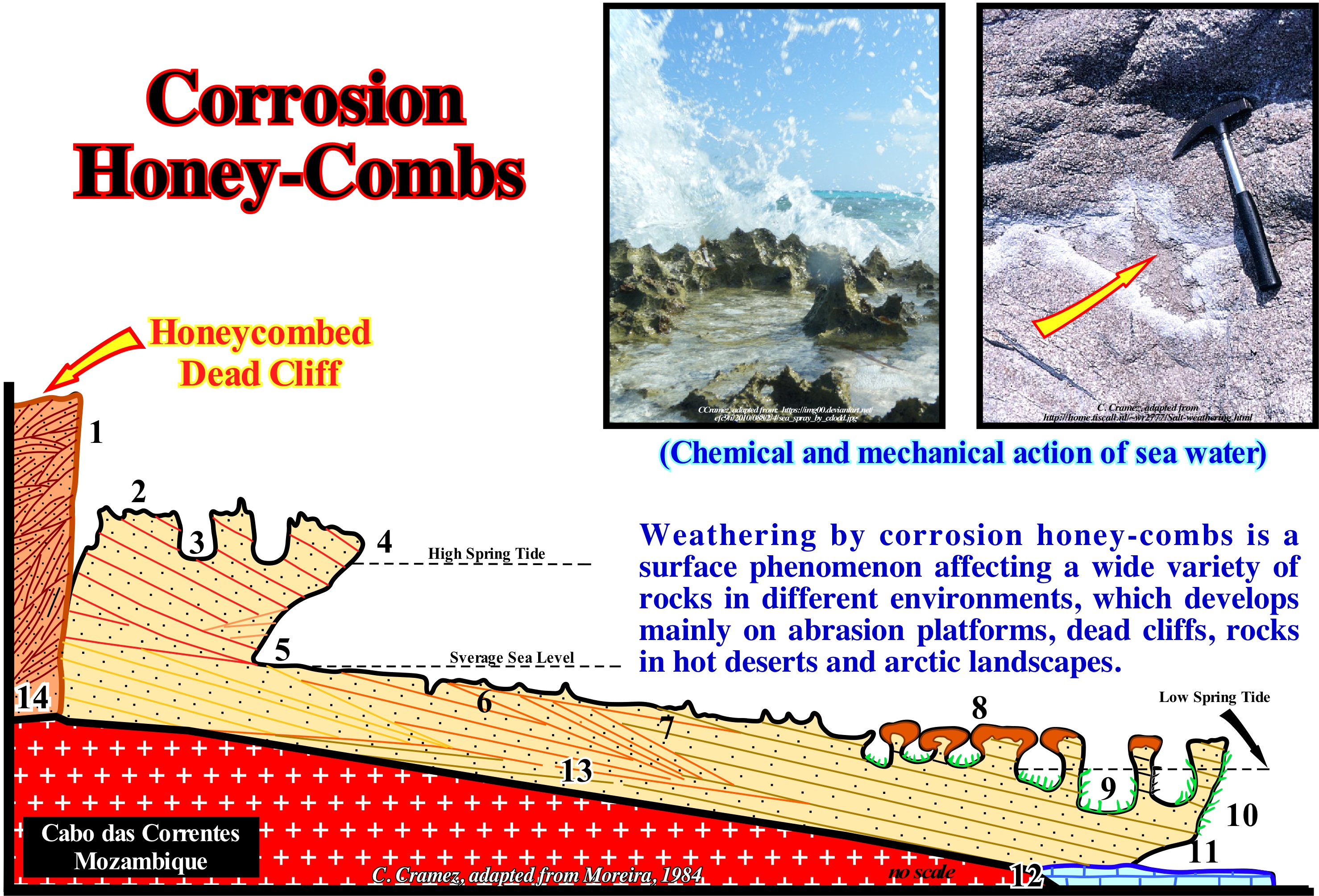
This geological section of the Cabo das Correntes (Mozambique) illustrates the various types of micro-forms that can be found in a coastal karst developed on the strand and supra-littoral zone: (1) Honeycomb Dead Cliff with corrosion alveoli ; (2) Platform with Pointed Clints; (3) Coastal Potholes ; (4) Visor of Active Cliff ; (5) Undercutting ; (6) Platform with Solution Benches and Embryonic Potholes ; (7) Platform with Solution Benches Encrusted of Calcareous Algae ; (8) Bioconstructed Platform by Polychaeta ; (9) Coastal Potholes ; (10) Cornice of Surf; (11) Groove Submerged ; (12) Dead Coral Bank; (13) Beach sandstone; (14) Aeolianite**. Some of these micro-forms are due to the impact of waves and wind, but others are created by corrosion, i.e., by the chemical action of seawater (when it contains carbonic, humic or nitric acid) in the calcareous and dolomitic material which causes a dissolution partial and chemical changes. Some geoscientists think that the biochemical action is very important in the development of the alveoli of corrosion, if not in the beginning, at least, in the enlargement of the form. In Cabo das Correntes, the predominant rocks are beach calcareous sandstones and aeolianites (aeolian calcoarenites, since they are terrigeneous limestones formed by the cementation of the limestone sands of the coastal dunes). Although in this example the coastal karst is, directly, associated with tides, it is evident that, in geological terms, it is partly conditioned by relative sea level changes (transgression-regression cycles). When the relative sea level rises in acceleration (increasingly important marine ingressions), the carbonated substrate is karsified in a, more or less, similar way at each eustatic paracycle, that is to say at each marine ingression***. Corrosion alveoli in the granite of St. Tropez (south of France) induced by salt-spray are visible in the photograph of the upper right corner of this figure
(*) The salt-spray is the foam cloud formed by droplets of sea-water and bubbles enclosing saline micro-crystals, resulting from the surfing foam that is projected against the coast and transported inland by the wind (Moreira, 1984).
(**) Rock formed by the consolidation and lithification of aeolian deposits from the cementation of the grains, mainly by the carbonate and calcium sulfate dissolved from fragments of shells and other minerals from the higher levels of the dunes. Aeolianites generally form from the equatorial regions to the latitude of 40° and are important in the conservation of the coastlines (http: // sigep. Cprm.gov.br/glossario/index. Html).
(***) Synonymous with transgression when this term is used to underline the gradual advance of the sea on the lands.
Cosmological Constant............................................................................................................................Constante cosmologique
Constante Cosmológica / Constante cosmológica / Kosmologische Konstante / 宇宙常数 / Космологическая постоянная / Costante cosmologica /
Constant introduced by Einstein in his equations of gravity, which corresponds to a cosmic repulsion, to prevent an expansion of the Universe. Theoretically, the cosmological constant had to be very large. However, in reality, it is zero or almost zero, that is, practically it can not be measured. The discrepancy between reality and theory is still poorly understood today.
See: « Inflationary Universe »
&
« Big Bang »
&
« Big Crunch »
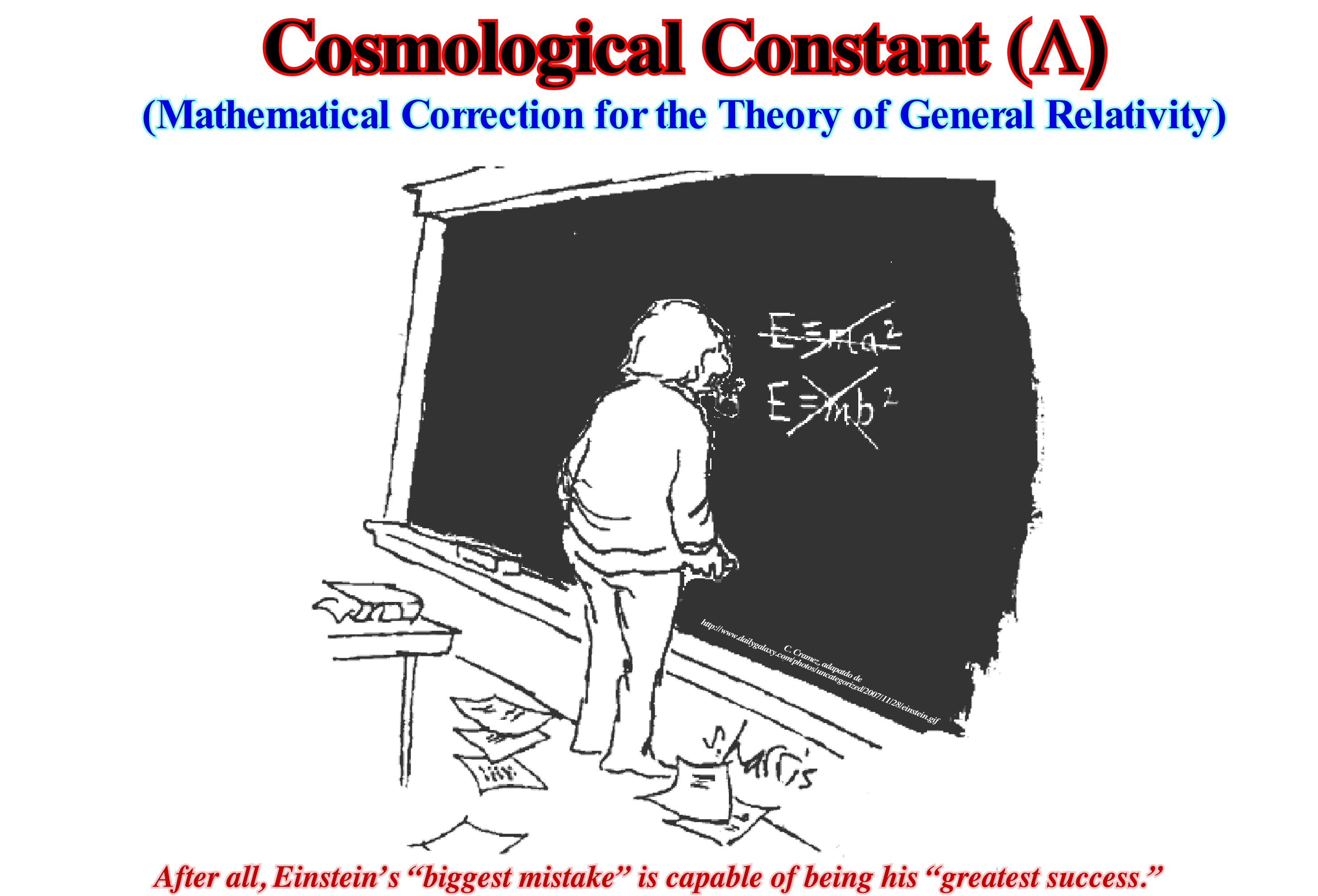
A new scientific project seems to indicate that Einstein was, probably, wrong to admit the biggest mistake of his life. In other words, Einstein was right, but he did not know why. For him, his biggest mistake was the introduction of a cosmological constant (a force that opposes gravity and prevents the Universe from collapsing), but it now seems, according to research by an international team of scientists, that it is very possible that he was right. That would mean that Einstein was so clever that even his biggest mistake is, probably, true. This scientific team is, currently, working on a project called ESSENCE, which studies the supernovae (stars that exploded) to find out if black energy - the accelerating force of the Universe - is consistent with Einstein's cosmological constant. Black or dark energy, as certain geoscientists say, is a hypothetical form of energy that would be distributed throughout space and tends to accelerate the expansion of the Universe (the main characteristic is to have a strong negative pressure, whose effect, according to theory of relativity, would be qualitatively similar to a force acting on a large scale as opposed to gravity). Einstein's so-called "error" was the introduction of the cosmological constant in 1917 when he worked on his theory of general relativity* and was trying to come up with an equation describing a static universe (universe that does not collapse under force of gravity, i.e., a universe without "Big Crunch"). Thus, in order to keep the universe static, Einstein introduced the celebrated cosmological constant. However, 12 years later, Edwin Hubble discovered the Universe is not static and it is, actually, expanding. Thus, Einstein considered the introduction of the cosmological constant was the biggest mistake of his life. However, in 1998, two teams of scientists discovered that the Universe is not only expanding but is accelerating, which seems to be right for Einstein.
(*) In 1905, Albert Einstein determined that the laws of physics are the same for all non-accelerating observers, and that the speed of light in a vacuum was independent of the motion of all observers. This was the theory of special relativity. It introduced a new framework for all of physics and proposed new concepts of space and time https://www.space.com/17661-theory-general-relativity.html). Einstein then spent 10 years trying to include acceleration in the theory and published his theory of general relativity in 1915. The theory of special relativity explains how space and time are linked, but it doesn't include acceleration. By including acceleration, Einstein later developed the theory of general relativity, which explains how massive objects in the cosmos distort the fabric of space-time. The theory explains how this distortion is felt as the force of gravity, as it predicts how much the mass of an object curves space-time. Scientists test relativity by observing objects in space and seeing if their behaviours match up with Einstein's explanations of space-time and gravity, for instance, by observing how light bends around massive objects as it travels towards Earth (https://www.space.com/topics/theory-of-relativity-in-space).
Cosmological Time........................................................................................................................................................Temps cosmologique
Tempo Cosmológico / Tiempo cosmológico / Kosmologische Zeit / 宇宙时间 / Космологические время / Tempo cosmologico /
Time between the Big Bang (t = 0) and the Earth's formation (t = 4.7 Ga). The cosmological time is divided into Planckian time, between t = 0 and t = 5.39 10-44 seconds, which corresponds to the Planckian Era, and Gamovian time, which is limited between 16.5 Ga and 4.7 Ga.
See: « Geologic Time Scale »
&
« Radiometric Datation »
&
« Geological Time »
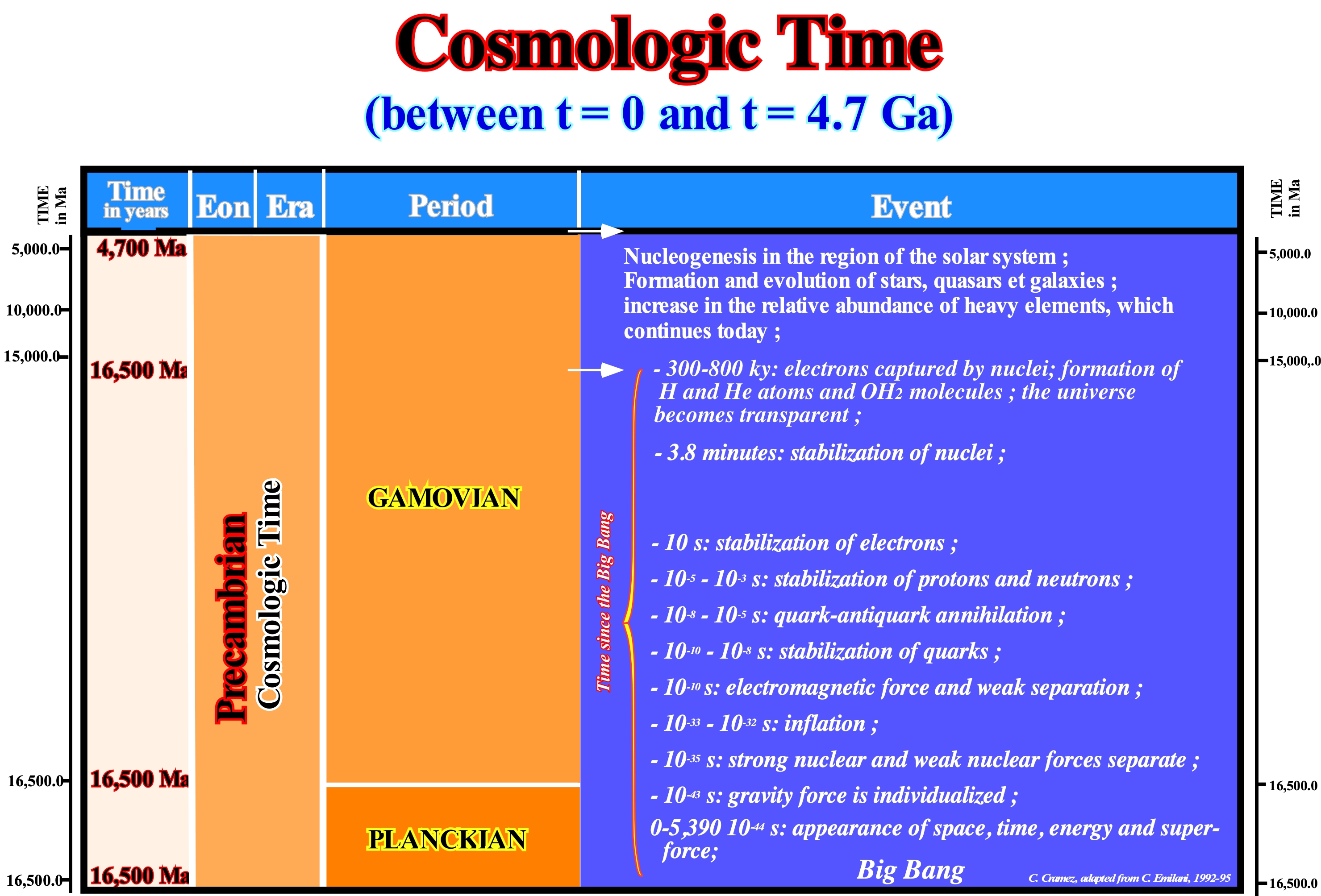
Assuming a probable value for the Hubble constant (current proportionality constant between the distance and apparent recession velocity of galaxies in the observable Universe, which has a radius of about 46 billion light years) of 18 km/s for 106 years, we get an age of 16.85 109 Ma for the Big Bang. The decimal number is illusory, since the error is, more or less, a few billion years. The time scale for the origin and Earth's evolution is, probably, much more rigorous than the cosmological time scale illustrated in this figure. However, the time between t = 0 and t = 5,390 10-44 seconds corresponds to the Planck period or era (the oldest period in the history of the Universe, between zero and 10-43 seconds, during which the four forces - gravitational, strong nuclear, weak nuclear, electromagnetic) were unified and there were no elementary particles (particles that do not have any substructure: fermions, bosons, etc.), the time interval defined by the Planck length, which is equal (Gh/2πc3)½π divided by the speed of light, which is equal to (Gh/2πc5)½ .The Planckian period is the interval of time during which space, time and energy were born. The Gamovian period corresponds to a long interval of time, from the end of the Planckian to the formation of the solar system (more or less up to 4,700 Ma). The Planckian is followed by the Gamovian who is the second eon of cosmological time. The Gamovian lasted from 5,390-44 seconds after time zero to 4.6 Ga, when the solar system formed. It is the longest era of cosmological time. During this time, the Universe was expanding. The extension rate has been increasing, steady, or decreasing. An increasing or constant rate implies an open Universe, or a universe that will expand forever. A rate of expansion in deceleration implies, asymptotically, to a finite radius (Flat Universe) or it can be zero or even inverted. In the latter case the Universe is closed, producing a cosmic collapse. It can be said during the Gamovian period, matter formed from the primordial radiation as it cooled and condensed. The stars formed and were associated in galaxies. More than 100 generations of massive stars appeared and disappeared, continuously enriching the interstellar matter of heavy elements. On this subject, it should not be forgotten recent observations have revealed that the Universe is, largely, constituted by the unknown. Seventy percent (70%) of the matter is in the form of black energy, twenty-six percent (26%) in the form of matter and only four percent (4%) in the form of ordinary matter, which means, less than a part in twenty of the matter of the Universe is observed experimentally and described by the standard model of the physics of the particles. Although in the last 10 years the cosmological knowledge has increased tremendously (partly due to Moore's law, which says that every eighteen months, the speed of the processor chips is multiplied by 2) no one knows much about 96% of the Universe. The Known Universe contains approximately 100 billion galaxies*, assembled in large groups and separated by vast empty spaces that may be filled with black matter of a still unknown nature. When the Universe's temperature dropped to 3,000° K (2725° C), about 800,000 years after the Big Bang, the energy was low enough for the atoms to become stable. Until then the electrons were free, giving the Universe an appearance of luminous fog, more or less, like the discharge of gas into a neon light. When the electrons were captured, the Universe became transparent to the radiations. However, there was nothing to see, since the density had already dropped to 1,6 1017 g/cm3, the stars had not yet formed and the radiation had a wavelength of about 3.2 μm, which is in the region infrared (not visible).
(*) C. Emiliani, 1992- Planet Earth. Cosmology, Geology, and the Evolution of Life and Environment.,Cambridge University Press, ISBN 0-521-40123-2 (hc).- ISBN 0-521-40949-7 (pb)
Cosmic Ray..........................................................................................................................................................................................................Rayon cosmique
Raio Cósmico / Rayo cósmico / Kosmische Strahlung / 宇宙線 / Космические лучи / Raggio cosmico /
Electrically charged particle (not radiation), which reaches the terrestrial stratosphere coming from all directions of space. Cosmic rays are, mainly, made up of protons, but it also contains several types of heavy atomic nuclei.
See: « Stratosphere »
&
« Cloud »
&
« Sun »
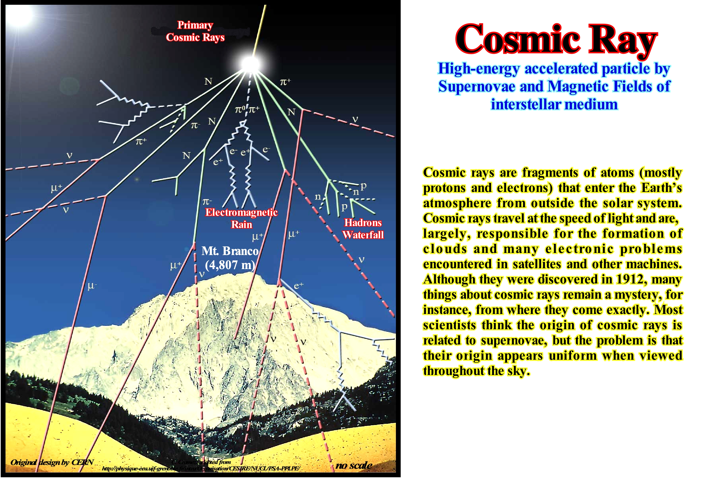
Cosmic rays are particles, extremely sharp, penetrating, high-energy, moving at speeds close to that of light in outer space. Never forget cosmic "rays" are not rays, but particles of atoms. These particles, as they penetrate the Earth, collide with the nuclei of atoms in the atmosphere, about 10,000 meters above the surface of the planet, and give rise to other particles, forming a "rain" of particles with less energy, so-called secondary cosmic rays. The number of particles reaching the sea level, on average, is one particle per second in every square centimetre. Secondary cosmic rays are harmless to life on Earth, but primary cosmic rays are dangerous to astronauts in space. At first it was thought the cosmic rays were formed of photons (elemental particle measuring one of the electromagnetic force, is the quantum of the electromagnetic radiation, including the light) endowed with intense energy, but after more studies, mainly, after is was possible to observe them by means of rockets and satellites, it was concluded this type of radiation was formed by particles of a distinct nature: the primary rays and the secondary cosmic rays. The primary rays are mostly protons, also having a certain proportion of particles and a very small percentage of heavier nuclei. They are those having a cosmic origin and travel close to the speed of light, penetrate the high layers of the atmosphere and collide with the hydrogen and oxygen atoms of the air, forming the secondary radiation that is formed almost exclusively of electrons. It is the speed of these particles that gives them the ability to penetrate matter. The cosmic rays of solar origin are rays with relatively low energy. The average composition is equal to that of the Sun itself. Solar cosmic rays vary in intensity and spectrum with solar events. The increase in solar cosmic rays is followed by a decrease in the other cosmic rays.
Cove (Bay).........................................................................................................................................................................................................................................Crique (Baie)
Enseada (baía) / Ensenada / Verbreitung Achse / コーブ (曖昧さ回避)/ Бухта (залив) / Cala (baia) /
Bay, more or less, circular with a small gateway.
See: «Bay»
Cracking ....................................................................................................................................................................................................................Cracking (Craquage)
Cracking / Craqueo / Krakning / 裂化反应 / Крекинг (растрескивание) / Cracking (chimica) /
Breaking of large hydrocarbon molecules into smaller and more useful molecules. Such a break can be done at very high temperatures and pressures or at much lower temperatures and pressures but in the presence of a catalyst*.
See: « Petroleum »
&
« Reserves »
&
« Resources »
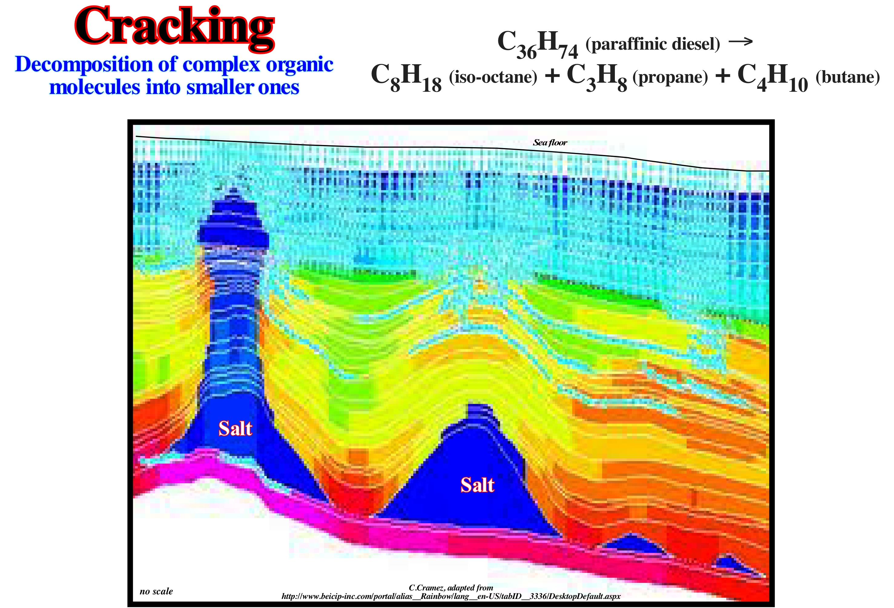
The cracking of the hydrocarbons corresponds to a thermal decomposition, i.e., the large molecules of hydrocarbons, when sufficiently heated, are broken into smaller molecules. The hydrocarbons are boiled and the resulting gases pass through an aluminium oxide (Al2O3) catalyst powder (substances favouring the destruction of chemical compounds), which provides a good surface for cracking to occur. Cracking in oil refineries allows the production of light products such as LPG ("Liquefied Petroleum Gas") and gasoline from products of the heavier fractions of petroleum distillation. FCC ("Fluid Catalytic Cracking") produces high-performance gasoline and LPG, while hydro-cracking produces fuel for jet, diesel, naphtha and LPG aircraft. Thermal cracking is usually used to enrich the heavy fractions or to produce light or distillate fractions, heating fuel and/or petroleum coke. BEICIP's Temis program is used in the 2D modelling of sedimentary basins to predict whether a particular oil prospect, before being tested by a research well, contains oil or gas. This program, shown in this figure, uses a cracking process that represents in detail the GOR (Petroleum Gas Ratio) and API (Petroleum Density of the American Petroleum Institute) of the hydrocarbons generated by cracking (main and secondary) and the algorithms** of the three stages of migration of the hydrocarbons that control changes in composition and phase. In addition, the Temis 2D program models the primary, secondary and tertiary migration of hydrocarbons from Darcy's multiphase law. The numerical scheme of the finite volume guarantees the law of Goguel (conservation of mass) and thus the validity of the results. The transport and phase separation is fully coupled without compromising neither the phase behaviour nor the flow equations.
(*) Substance that increases the speed of a chemical reaction without being consumed.
(**) An algorithm is a finite and unambiguous sequence of operations or instructions to solve a class of problems. The notion of problem can be seen in a broad sense, it can be a task to perform, such as sorting objects, cooking, assigning resources, transmitting information, translating text, etc.. In computer science, an algorithm is a procedure, i.e., a sequence of instructions that allows a software to produce a certain result. Similarly, when we do an addition by hand we follow an algorithm, as well as when we follow a cooking recipe to get a good meal, we also follow an algorithm.
Crater.............................................................................................................................................................................................................................................................Cratère
Cratera / Cráter / Krater / 火山口 / Кратер / Cratere /
Circular depression caused by intense volcanic activity. A depression caused by the collision between two celestial bodies, such as when a meteorite strikes the Earth, is called an impact crater. Synonym of Caldera.
See: « SDR (reflector dipping seaward) »
&
« Vulcan »
&
« Vulcanism »
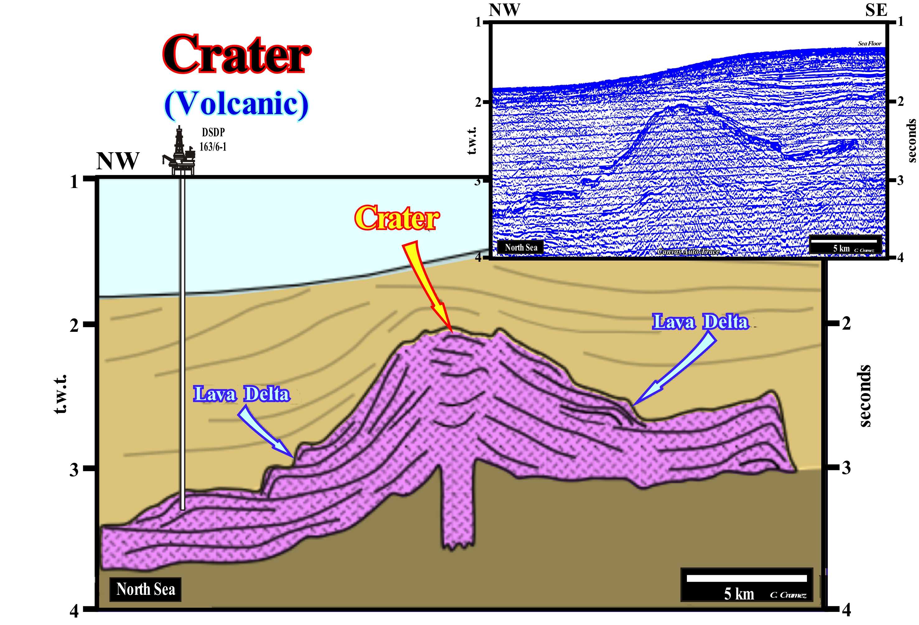
This tentative geological interpretation of a Canvas auto-trace of a North Sea seismic line is proposed to explain the shape and geometry of Darwin's seamount. Although the position of the vertical feeding dyke of the volcanic material is speculative, the morphology and internal structure (reflectors configuration) of the submarine seamount are obvious. The crater corresponds to the central depression, at the top of the submarine seamound. This crater was built, progressively (vertical construction), as the sub-aerial lavas flowed in, more or less, opposite directions. In the upper and thick parts of the submarine seamount (central parts contiguous to the crater) the dip of the reflectors are much stronger than in the lower parts far from the crater. This structural behavior indicates, roughly, the flow direction and the aggradation of the sub-aerial lavas, since under water, the volcanic material does not flow. As the flow can be followed over several kilometers, it is evident that the lavas are flowed in the open air or at least sub-aerially.. This conjecture is, perfectly, corroborated not only by the results of the well DSDP ≠ 163/6-1 (located at the left end of this seismic line), but also by the step morphology (lava deltas) of the submarine seamount. In close-ups of this auto-trace (as seen, too, on the large step marking the SE end of the submarine seamount), the internal reflectors correspond to high dip downlaps. The geological mechanism, most likely to explain the morphology and internal configuration of this volcanic interval, is a progressive construction of the submarine seamount, in a sub-aerial environment (between epicontinental seas or other large waterbodies), in which the lavas normally flow, in the opposite direction from the crater. Do not forget that, as the lavas enter a water-body, they solidify, rapidly, creating abrupt cliffs, such as those illustrated above, which certain geologists call lava deltas.
(*) Lava deltas are similar to river deltas. They form when sub.aerial lava flows enter bodies of water (sea or lake). The lava cools and splits as it enters the water, since lava can not flow into water. The resulting fragments fill the topographical depressions of the seabed in order that the flow may progress further outwards, which gives it a prograding geometry similar to that of the river deltas.
Craton (Shield)................................................................................................................................................................................................................................Bouclier
Cratão / Cratón / Craton, Schild / 克拉通, 盾 / Кратон, щит / Cratone, Scudo /
Stable area of a continent that escaped orogenic activity of the last 2G years. A craton is composed, predominantly, of granite and metamorphic rocks.
See: « Supercontinent »
&
« A-type Subduction (Ampferer) »
&
« Continental Collision »
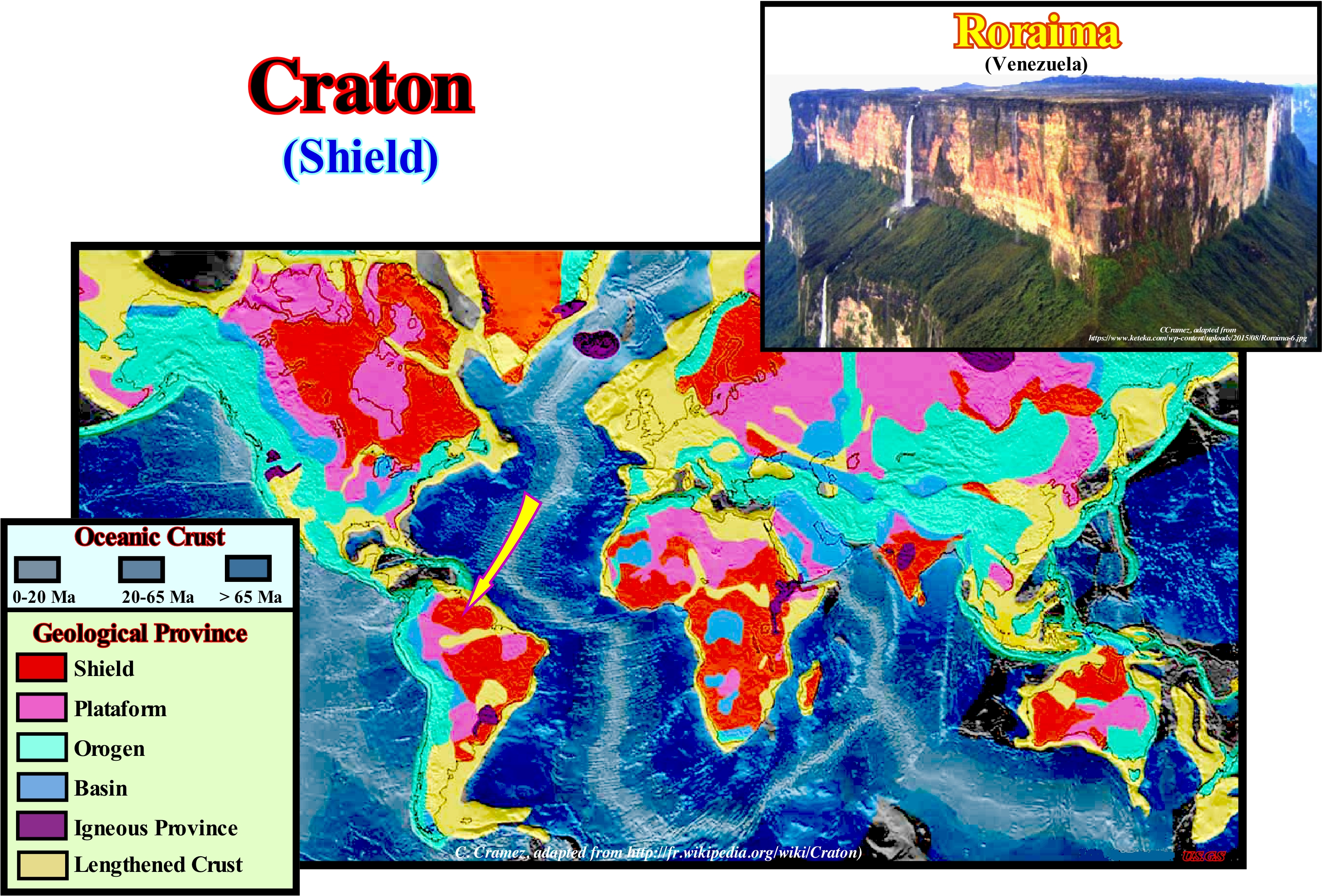
Usually, the cratons or shields are regions of stability where during long geological periods the formation of mountains does not occur. They form the nucleus of the continents or the substrate of ocean basins. They may be, partially, covered by thinly sedimentary layers such as in Central Asia and in the central part of North America. Sometimes they are surrounded by young mountain ranges made up of very deformed sediments, called orogens* (tectonic province where several geological processes related to the confrontation of lithospheric plates and the origin of the Earth's great mountainous belts). In this case, certain geoscientists speak of platform. The cratons can be deformed by faulting, but hardly by folds, particularly the inner part. The process by which the cratons are formed is called cratonization, which can be defined as the gradual transformation, from the end of the Archean, of unstable areas into stable areas, which are differentiated function of the movement rate in a given time interval. The craters are sub-divided, geographically, into geological provinces (spatial entities with common geological attributes). A geological province may include a single dominant structural element such as a structural basin, a mountain range or a number of contiguous related elements. Adjacent geological provinces may be similar from a structural point of view, but can also be considered, separately, when they have different geological histories. In Northern Hemisphere, the most important cratons are: (i) Angara (Western Siberia crater) ; (ii) Scandinavia (encompassing Northern Europe) and (ii) Canadian Shield (encompasses the northern regions of Saskatchewan, Manitoba, Ontario and Quebec, as well as most of Labrador). In Southern Hemisphere, the main cratons are: (a) African (encompasses five continental masses, from the Precambrian, which came together at the end of Precambrian and early Paleozoic to form the African continent: West Africa, Kalahari, Congo, Sahara and Tanzania) ; (b) Antarctic (covering about 10 Mkm2, that is to say, 73% of the Antarctic continent, but is almost entirely buried by the Antarctic East ice cap ; it is formed by Mawson craton and several other marginal cratons) ; (c) Australian (composed of a whole series of craters including: Altjawarra, Central, Curnamona, Gawler, Pilbara, Yilgarn, etc.) and (d) Brazilian (the Guiana craton (Roraima is shown in this figure) and Central Shield of Brazil constitute, respectively, the exhumed parts of the north and south of the craton ; smaller cratons are found southward, as the Plata River craton and San Francisco craton). The first large cratons formed during the Archean, when the terrestrial heat flux was probably about three times greater than today. The concentration of radioactive isotopes and the residual heat were very large. The tectonic and volcanic activity were also very large. The earthly mantle was much more fluid and the crust finer. All this contributed not only to a very rapid formation of the oceanic crust, in the mid-oceanic ridges** and in the hot spots (thermal anomalies in the interior of the Earth, associated with convection systems of the mantle and responsible for the volcanism occurring in the interior lithosphere plates), but also to a rapid recycling of oceanic crust in B-type or Benioff subduction zones (when an oceanic lithosphere plate dips under a continental lithosphere plate). The Earth's surface was, probably, broken up into relatively small lithospheric plates (tectonic plates) with many islands and oceanic or continental volcanic arcs (chain of mountains or volcanic islands formed in B-type subduction). Small protocontinents (cratons) formed as the crust rocks were melted by the hot spots and recycled in the subduction zones of Benioff. Certainly, there were no large continents in the Archaic. Small continents were predominant, since coalescence was difficult due to the high rate of geological activity.
(*) The orogenic belts are divided into two regions: (i) Hinterland, which is the domain of large vertical deformations and magmatism and (ii) Borderland, which is the domain of the tectonics of shortening by thrusts (scales) and the great thrusts with deformations and metamorphism that attenuate towards the foreland basins. An accretion orogen is associated with a B-type subduction zone (Benioff), such as the Andes, whereas a collision orogen is associated with an A-type subduction zone (Ampferer), such as the Alps or the Himalayas.
(**) Large submerged mountain ranges, located in the central part of the Earth's oceans, resulting from the oceanic spreading between lithospheric plates, whose height above the surrounding ocean floor is about 2000 to 3000 meters. In the central region of a mid-oceanic ridge there is an axial groove, called "rift" (which has nothing to do with the riff-type basins of the classification of the sedimentary basins of Bally and Snelson) along which lava rise from magma of the sublithospheric mantle.
Cratonic Basin.....................................................................................................................................................................................Bassin cratonique
Bacia cratónica / Cuenca cratónica / Kratonischen Becken / 克拉通盆地 / Автогеосинклиналь / Cratonica bacino /
Sedimentary basin developed in an old continental crust by a regional thermal subsidence, generally, above an older rift-type basin (belonging to another continental breakup system). This type of basin is not associated with the formation of a megasuture, but, indirectly, with the formation of new oceanic crust.
See: " Basin (sedimentary) "
Cratonisation...........................................................................................................................................................................................................Cratonisation
Cratoniração / Cratonización / Bildung einer Kraton / 克拉通的形成 / Кратонизация / Formazione di un craton /
Formation of a large and stable portion of the continental crust. Cratons are the central areas of the great continents, with a poorly marked topography, which make up most continental areas.
See :« A-type Subduction (Ampferer) »
&
« Craton »
&
« Continental Collision »
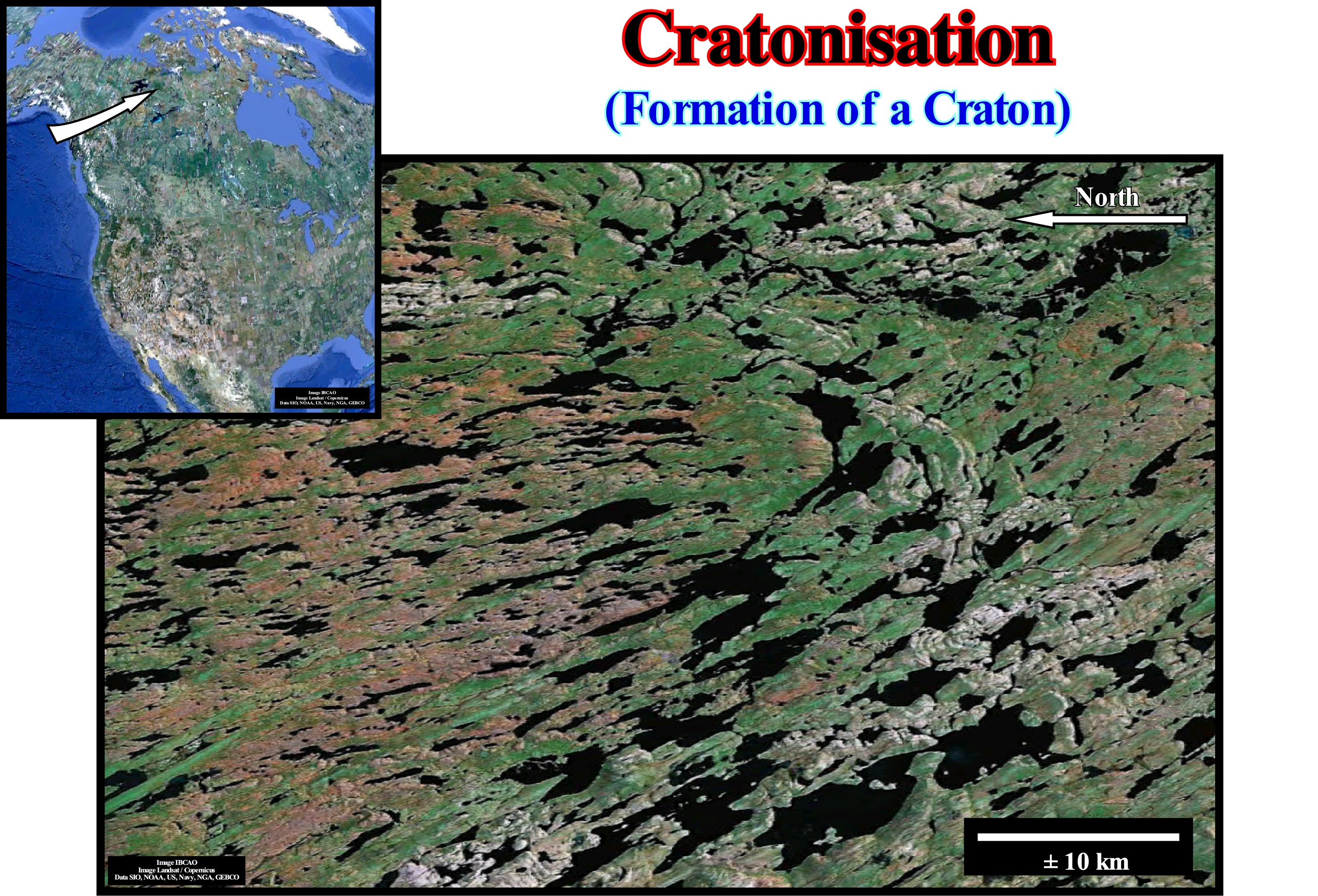
Cratonization is the, more or less, gradual passage from an unstable area to a stable area. It occurred since the end of the Archean eon. Currently, stable areas or cratons occupy about 20-25% of the Earth's total surface area. These stable areas were called cratogens by the Austrian geoscientist Leopold Kober (1921). Later, the term cratogen was abbreviated, probably by Hans W. Stille, in craton ("kraton"). Examples of cratons are: Slave (Canada) ; Wyoming (United States) ; Amazonia (South America) ; Kaapvaal (South Africa) ; Gawler (Australia), etc. This figure shows a sector of the Slave craton, which is located in Northwest Canada, near Yellowknife. It constitutes the Northwest segment of the Canadian Shield of the great craton of North America. The Slave craton is a simple fragment of the ancient continental crust, surrounded by divergent continental margins of the Paleoproterozoic (Era of the Proterozoic Eon comprised of about 2.5 Ga to 1.6 Ga, or 2.5 and 1.6 billion years ago). Cratons such as the Slave are vestiges, that testify to segments of ancient pre-tectonic and tectonic systems in which they formed. Slave craton was formed by the breakup of a huge Archean continental mass and witnessed a complex, particularly, heterogeneous crust of the Earth, whose accretion lasted about 1.5 Gy. The original land mass could have been the speculative supercontinent Kenorland (Late Archean) or, more likely, a smaller, land mass, often referred as the Sclavia supercraton. In general, Earth's cratonization can be summarized as follows: (i) At the beginning of the Precambrian, the intense bombardment of the Earth by meteorites (denomination given when a meteoroid, i.e., a fragment of material wandering in space), formed by fragments of asteroids* (they are rocky and metallic bodies that have a defined orbit around the Sun) or comets or rest of disintegrated planets, that can vary in size from simple dust to celestial bodies with kilometers of diameter, reaches the surface of the Earth) to around 3.8 Ga ; (ii) The first continental crust blocks formed from the mantle**, which is above the nucleus and below the crust ; (iii) The first continental blocks grew by the accretion of new metamorphic lands produced by orogenies ; (iv) Initially, the continental blocks were, more or less, dispersed ; (v) Progressively, the primitive continental blocks were eroded ; (vi) Detrital material, resulting from the erosion of primitive continental blocks, deposited on the adjacent continental shelves ; (vii) Mountain chain formation and metamorphism***, deformed and transformed the marine sediments that served as cement during the agglutination of these blocks (supercontinents) ; (vii) These stable continental clusters constitute the cratons, which are mainly formed of granites and gneisses**** ; (ix) Several cycles of supercontinent fracturing and agglutination of the continents formed by fracturing seem to have existed in Earth's history.
(*) The asteroids can be aerolithes or rocky, sideritic, i.e., metallic or siderolithic i.e., metallic-rocky.
(**) The mantle is an inner layer of a terrestrial planet or some other rocky planetary bodies, to be formed implies that the planetary body is large enough to have undergone the process of planetary differentiation in terms of density. The boundary between the mantle and the crust is marked by the discontinuity of Mohorovičić (4-70 km). The upper mantle is composed of anhydrous peridotites and eclogites and their mean density is 3.3-3.4 g / cm3 and goes to a depth of about 680 km (+/- 20 km). The lower mantle, which extends up to ± 2,900 km deep, has the same composition as the upper mantle, but is probably at a different stage. Its density reaches about 5.6 g / cm3 in the deep part.
(***) Set of transformations undergone by a sedimentary rock, metamorphic or igneous, under the effect of changes in temperature, pressure, nature of the fluids, and sometimes the chemical composition of the rock , which may be mineralogical, structural, chemical or structural, lead to a reorganization of the rock elements and recrystallization of minerals in the associated solid state
(****) Metamorphic rocks resulting from the deformation of sediments rich in arkose (detrital sedimentary rock composed of quartz grains, feldspars, some lithic fragments and a cement of less than 15%, in other words, arkose is a sandstone with a high feldspar content of more than 25%) or granites, the composition of which is variable but more than 20% potassium feldspar (mainly orthoclase, KALSi3O8 ; plagioclase and still quartz and biotite and that is why gneisses are considered as rocks, essentially quartz-feldspars.
Creep (Rolling).........................................................................................................................................................................................Mouvement rampant
Escorregamento / Rodamiento (transporte) / Kriechen (Geologie) / 蠕变 (地质学) / Ползучесть (геология) / Creep (geologia) /
One of several ways in which sedimentary particles* of the drag load can be transported in a flow. The sedimentary particles (debris) are usually transported by a combination of: (i) Rolling or dragging over the substratum ; (ii) Saltation (jumping in the flow and then resting on the substrate) and (iii) Suspension in the flow.
See: « Transportation (sediments) »
&
« Sediment »
&
« Flux (flow) »
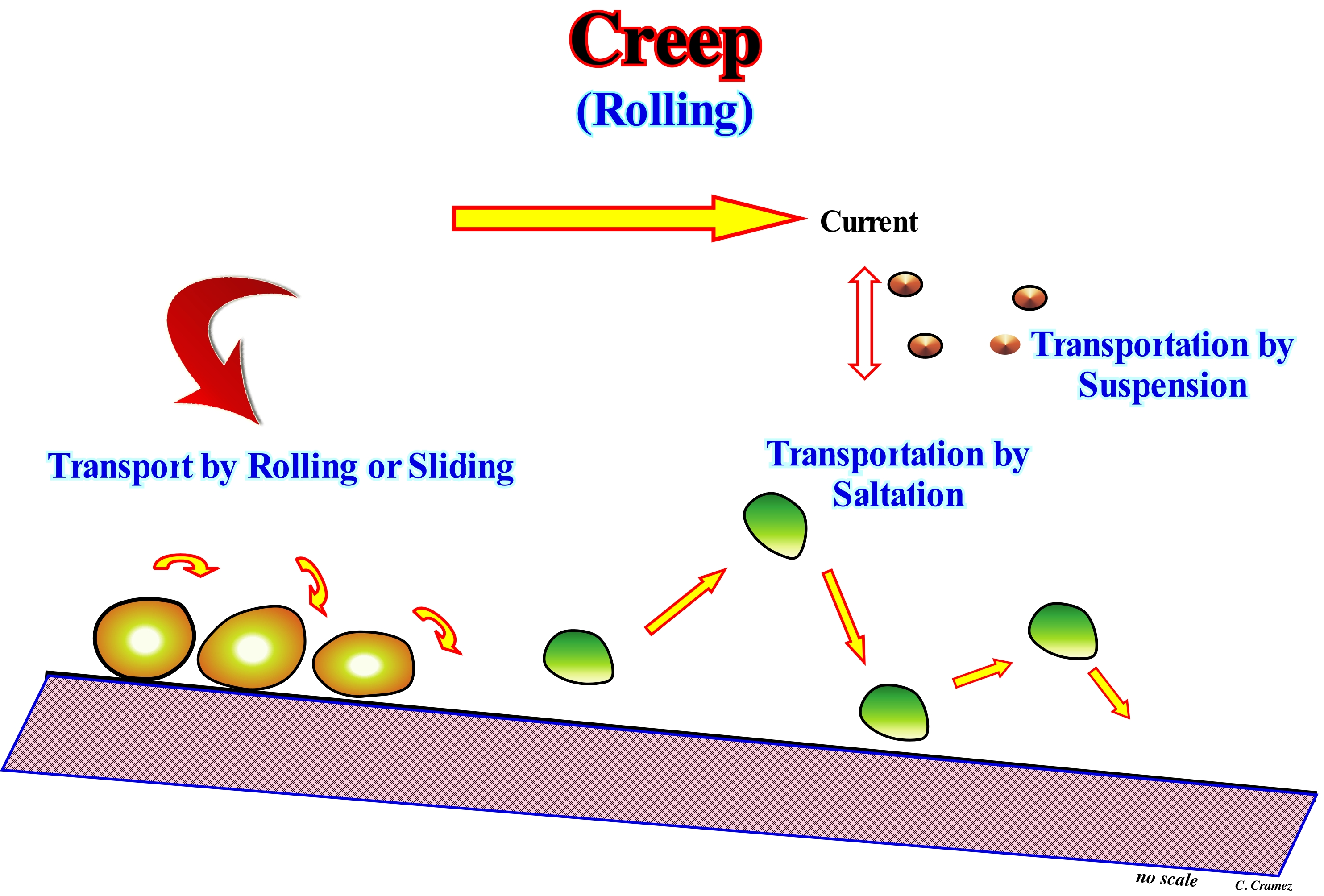
The bed-load** or solid bottom load (dragged load for certain geoscientists) moves either by rolling, sliding and saltation over the bed of the current and moves at a small fraction of the velocity of the water flow. The bed-load is, usually, 5-10% of the total sediment load carried by a stream, which makes it the least important displacement process in terms of mass balance. The bed-load material (trailing load plus suspended load, which comprises material derived from the stream bed) is, often, dominated by gravel loading of the river bed. This bed-loading material is the only part of the sediment load that interacts, actively, with the bed and thus plays an important role in controlling the channel morphology. In a current there are three types of load: (i) Traction-load; (ii) Suspended-load and (iii) Dissolved-load. Sediment transport is the movement of solid particles (called sedimentary particles) due to a combination of the force of gravity acting on the sediments and/or the movement of the fluid in which the sediments are rolling or sliding. An understanding of sedimentary particles transport is fundamental in natural systems, where particles are clasts of rocks (sand, gravel, pebbles, etc.), mud or clay, and the fluid is air, water or ice, and in which the force of the gravity acts to displace the particles that rest on, more or less, inclined surfaces. Particles transport is due to the movement of fluids occurring in rivers, oceans, lakes, seas and other water-bodies due to currents and tides and in glaciers that flow downstream, and on land surfaces under the influence of wind. Transport of sedimentary particles (debris) induced just by gravity may occur on inclined surfaces, such as slopes, escarpments, cliffs, prodeltas and continental slopes.
(*) Sedimentary particles range from the fine dust transported by high-altitude winds to gigantic erratic blocks moved by glaciers. Standard sieve sizes are: (i) Small Boulder > 250 mm of diameter ; (ii) Large Cobbles between 128 and 256 mm ; (iii) Small Cobbles between 128-64 mm ; (iv) Very Coarse Gravel between 64-32 mm ; (v) Coarse Gravel between 32-16 mm ; (vi) Medium Gravel between 16-8 mm ; (vii) Fine Gravel between 8-2 mm ; (viii) Very Fine Gravel between 4-2 mm ; (ix) Very Coarse Sand between 2-1 mm ; (x) Coarse Sand between 1-0.5 mm ; (xi) Medium Sand between 0.5-0.25 mm ; (xii) Fine Sand between 0.25-0.125 mm ; (xiii) Very Fine Sand between 0.125-0.062 mm ; (xiv) Coarse Silt between 0.062-0.031 mm ; (xv) Medium Silt between 0.031-0.016 mm ; (xvi) Fine Silt between 0.016-0.008 mm ; (xvii) Very Fine Silt between 0.008-0.004 mm ; (xviii) Coarse Clay between 0.004-0.002 mm ; (xix) Medium Clay between 0.002-0.001 mm ; (xx) Fine Clay between 0.001-0.0005 mm ; (xxi) Very Fine Clay between <0.0005 mm.
(**) The load (discharge, tonnes/year) or production (tons/km2/year) of sedimentary particles (in suspension and as the bed-load of sand and gravel) through the water-coures reflects the erosion of the upstream land within the drainage basin.
Crest (Wave)....................................................................................................................................................................................................................................................Crête
Crista / Cresta / Wellenkamm, Wellenberg / 波峰 / Гребень (волны) / Cresta /
Convex part of a wave, whether it is a sea-wave or an acoustical-wave.
See : « Wavelength »
&
« Beach - Ridge, Strom Beach »
&
« Wave Height »
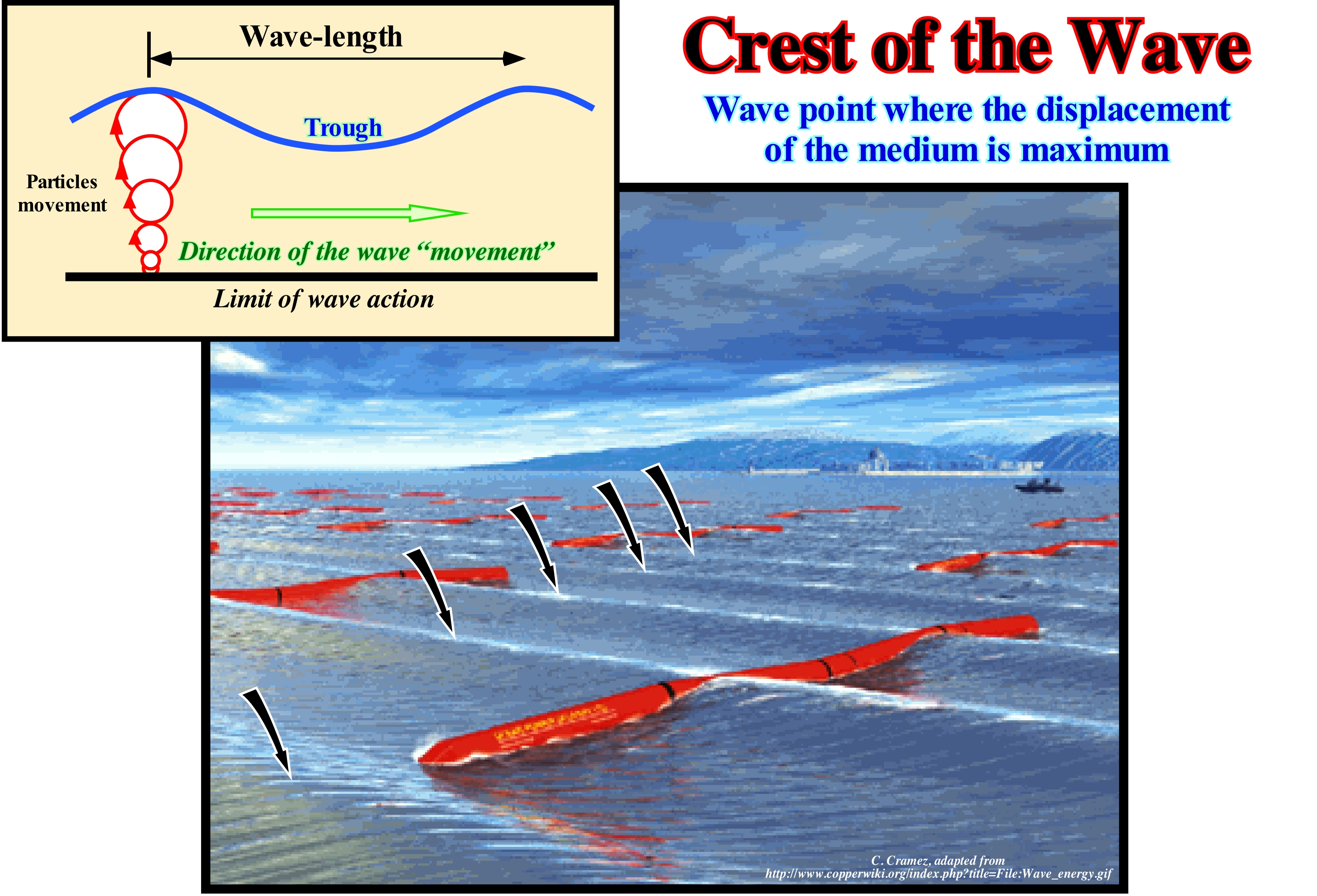
In this photograph, the crests of the waves are very visible. They are, more or less, equidistant from each other, and the axis of the crests are practically parallel to each other but oblique to the shoreline. Under these conditions, after the breaking of the waves, two coastal currents ( with different directions are formed: (i) Uprush* and (ii) Backwash**. The direction of the uprush current is perpendicular to the crests of the sea-waves, but the direction of the backwash current follows the slope of the sea floor. In scientific terms a wave is a disturbance that propagates in space and time and which, normally, transfers energy. However, while a mechanical wave propagates in a medium (which when deformed is capable of producing elastic restoring forces), an electromagnetic radiation wave (and probably also a gravity radiation wave) travels in a vacuum, i.e., they do not need any medium to propagate. Sea-waves travel and transfer energy from one point to another through oscillations around fixed points and, often, with little or no displacement of the particles in the medium. Periodic-waves are characterized by crests (high points) and troughs (low points) and can, usually, be classified into: a) Transverse waves and b) longitudinal waves. Transverse waves have vibrations perpendicular to the direction of propagation. Longitudinal waves vibrate parallel to the direction of propagation. When an object in the sea or in a lake moves up and down, it follows an orbital trajectory. The waves are not sinusoidal transverse waves, but a combination of transverse and longitudinal waves. The wave-length (∂), which is the distance between two consecutive crests or troughs, is determined, usually, in meters. The number of waves (k) is associated with the wave-length (∂) by the mathematical relation k = 2π / ∂. The period T is the time of a complete cycle of oscillation of a wave, i.e., the time between two consecutive ridge. The frequency f (or v), which is the number of periods per time unit (usually a second), is expressed in hertz: f = 1/T. The wave-length, i.e., the distance between two consecutive crests is a function of the depth of the sea, which corresponds roughly to half the wave-length.
(*) Swash current formed after the breaking of the waves (transformation of oscillation waves to translation waves) that moves continentward.
(**) Swash current that moves seaward following the slope of the sea floor. It results from the inversion of the uprush current, due to the loss of energy caused by the slope and the friction of the sea floor.
Cretaceous.......................................................................................................................................................................................................................................Crétacé
Cretácio / Cretácico, Cretáceo / Kreide / 白垩纪 / Меловой период / Cretacico /
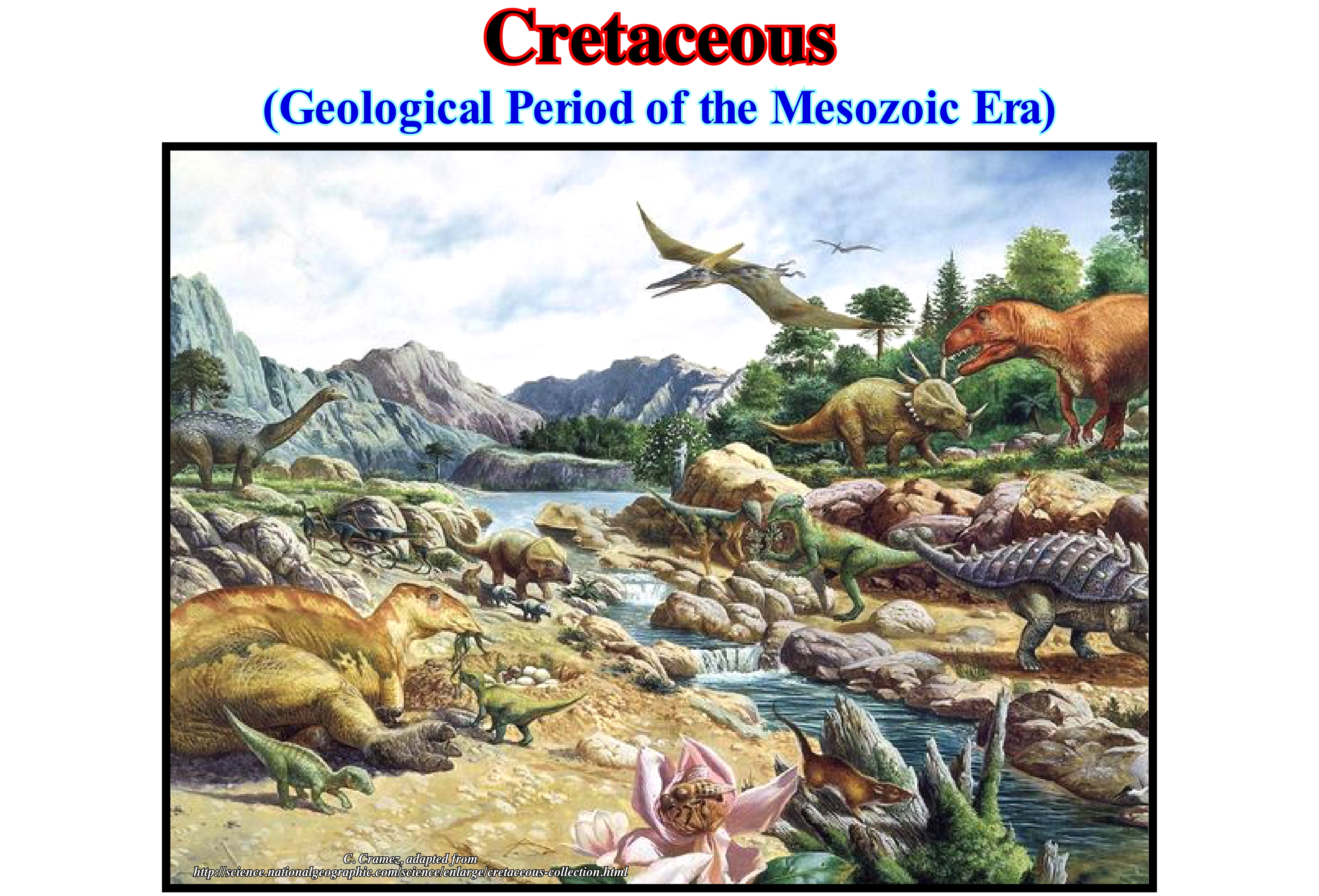
One of the largest divisions of geological time, limited between the end of the Jurassic (about 144.2 million years ago) and the beginning of the Paleocene Epoch (about 65 Ma). The Cretaceous is the longest geological period of the Mesozoic.
See: « Geological Time »
&
« Mesozoic »
&
« Eustasy »
The Cretaceous marks the boundary between the Mesozoic and Cenozoic Eras. It is sub-divided into Lower and Upper Cretaceous. From the bottom to the top, and according to J. Hardenbol et al., 1998, the Lower Cretaceous is sub-divided into: Berriasian (144.2 ± 4.0 to 137.0 ± 3.0) ; Valanginian (137.0 ± 3.0 to 132.0 ± 2.0 Ma) ; Hauterivian (132.0 ± 2.0 to 127.0 ± 1.5 Ma) ; Barremian (127.0 ± 1.5 to 121.0 ± 1.0 Ma) ; Aptian (121.0 ± 1.0 to 11.2 ± 1.0 Ma) ; Albian (112.0 ± 1.0 to 98.9 ± 0.9 Ma). The Upper Cretaceous is composed of: Cenomanian (98.9 ± 0.9 to 93.5 ± 0.8 Ma) ; Turonian (93.5 ± 0.8 to 89.0 ± 1.0 Ma) ; Coniacian (89.0 ± 1.0 to 85.8 ± 0.7 Ma) ; Santonian (85.8 ± 0.7 to 83.5 ± 0.7 Ma) ; Campanian (83.5 ± 0.7 to 71.3 ± 0.6 Ma) and Maastrichtian (71.3 ± 0.6 to 65.0 ± 0.3 Ma). The boundary between the Cretaceous and the Tertiary is one of the most dramatic events in Geology. The statistical analysis of marine fossils suggests that the great decrease in diversity was, probably, caused by extinctions rather than by a decreasing in species specification. Several theories have been advanced to explain the mass extinction* between the Cretaceous and the Tertiary. They are, mainly, based on the impact of a meteorite or a major increase in volcanism. Some of them come into account with these two elements. However, another scenario comes into account with: (i) An impact with an extraterrestrial body ; (ii) Volcanism and (iii) A regression, meaning that terrestrial and marine communities have suffered the consequences of changes or losses in their natural environments. For instance, dinosaurs, which were the largest vertebrates of the time, were certainly the first to be affected by environmental changes at the same time, that the extrusion of volcanic material sterilized important areas of the globe. The difference between this last hypothesis, which invokes several causes, and those that invoke only one cause is that they do not explain in themselves the extent of mass extinction.
(*) A species can last between 100,000 years and up to 10 x 109 because of its complexity. In complex organisms, mutations are faster and therefore they evolve more rapidly. The extinction of a single species or group of more or less related species, or even that of a family, is not regarded as a mass extinction. A mass extinction is characterized by the extinction of a large number of species belonging to different genera and families and living in different environments, which can only happen following important, global and rapid environmental change affecting a large number of environments. To date there have been five mass extinctions: (i) in the Ordovician, more or less, 450 Ma, it seems to have decimated more than 60% of life on Earth ; (ii) In the Devonian, some 360 Ma, a series of extinctions and not an isolated event, decimated about three-quarters of all the Earth's species ; (iii) In the Permian/Triassic, 250 Ma, which is considered the largest of the mass extinctions, since about 96% of species disappear (many geoscientists think that it was provoked by a very strong increase in temperature following a massive volcanic eruption in Siberia that would have also affected the oxygen content in the atmosphere) ; (iv) In the Triassic/Jurassic, about 200 Ma destroyed several species (about 20% of all marine families were exterminated by volcanic eruptions and climate changes associated with the breakup of the Pangea supercontinent ; v) In the Cretaceous/Tertiary about 65 Ma, which is the best known of all mass extinctions because the dinosaurs have disappeared and for which two main explanations have been advanced: (i) The impact of an asteroid with more than 10 km of diameter that created the crater of Chicxulub, in the Peninsula of Yucatan and (ii) A strong activity volcanic activity.
Cretaceous Marine Source-Rock.............................................................Roche-mère marine du Crétacé
Rocha-mãe marinha do Cretácico / Roca madre marina del Cretácico / Kreidezeit marine-Muttergestein / 白垩世海相烃源岩 / Морская материнская порода мелового периода / Roccia fonte marina delle Cretaceo /
A marine rock, rich in organic matter, deposited at the peak of the Cretaceous "transgression", which has been, sufficiently, buried to its organic matter reaches the oil window and which has a sufficient charge to feed accumulations, economically, profitable.
See : « Sealing-Rock »
&
« Source-Rock »
&
« Reservoir-Rock »
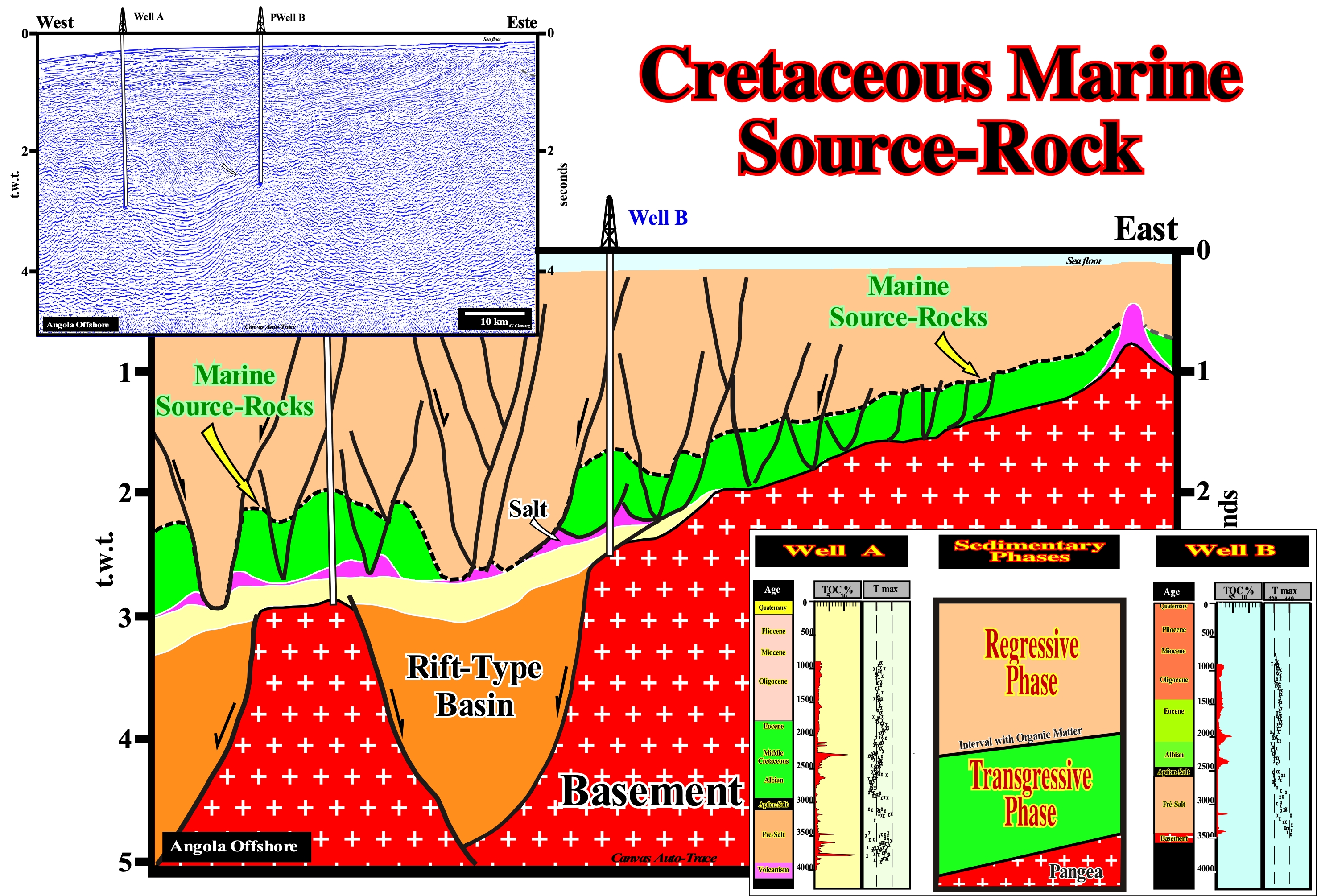
As shown on this tentative geological interpretation of a Canvas auto-trace of an Angola offshore seismic line, the Cretaceous marine source- rocks are associated with the peak of Cretaceous transgression (Cenomanian-Turonian, 93.5 to 89.0 Ma and, most probably, with the downlap surface 91.5 Ma). They correspond to the interface between the transgressive and regressive phase of the post-Pangea stratigraphic continental encroachment cycle. Practically, on the field and on the seismic lines, they correspond to the interface between the retrogradational geometry of the transgressive sediments and the progradational geometry of the regressive sediments (on this line these geometries are slightly hidden by the salt tectonics). The Cretaceous marine source-rocks were deposited when the absolute (eustatic) sea level* was maximum. In fact, the absolute sea level rose since the break-up of the Pangea supercontinent till the Cenomanian-Turonian, that is to say, until the maximum dispersion of the continents individualized by such a breakup. As the continents began to approach each other and the subduction of the oceanic crust became preponderant, the absolute sea level began to fall till today (increase of the volume of the ocean basins). Cretaceous marine source-rocks generated about 30 % of all hydrocarbon reserves (oil, gas, and condensate), currently, known. As the marine source-rocks of the Jurassic generated about 25% of the hydrocarbon reserves, it can be said about 55-60% of the hydrocarbon reserves were generated by the source-rocks deposited during the transgressive phase of the post-Pangea continental encroachment stratigraphic cycle, which was induced by the last Phanerozoic 1st order eustatic cycle, i.e., the post-Pangea eustatic cycle. These percentages do not take into account the huge amount of hydrocarbons lost during the formation of Pangea, which is difficult to predict.
(*) The sea level can be absolute or relative. The absolute sea level, which is supposed to be global is referenced to the Earth's centre, while the relative sea level is referenced to any point of the Earth's surface, which can be the sea floor or the base of the sediments (top of the continental crust). The relative sea level is the result of the combined action of the absolute sea level and the tectonics. The absolute sea level is induced mainly, by: (i) Changes in the volume of water in the global ocean (glacio-eustasy) ; (ii) Changes in the global volume of the ocean basins (tectono-eustasy) ; (iii) Distribution of ocean water caused by variations in the earth's gravity field (geoidal-eustasy) and (iv) Increase in the temperature of the oceans (steric sea level rise or thermal expansion of the oceans).
Crevasse (Glacial fissure)...................................................................................................................................................................Fissure (Fente glaciaire)
Fissura glaciária / Fisura (grieta glaciar) / Gletscherspalte / 冰隙 / Расщелина в леднике / Crepaccio /
Fissure, more or less, vertical of a glacier or a firn created by the stresses induced by the differential movement of the ise over a rough surface. Crevasses can reach more than 100m depth, and sometimes, be hidden by snow bridges. In geomorphology, crevasse is, also, used do name the ruptures of banks of a river or channel. Synonym of Glacial Fissure.
See: « Glacier »
&
« Firn »
&
« Crevasse-Splay »
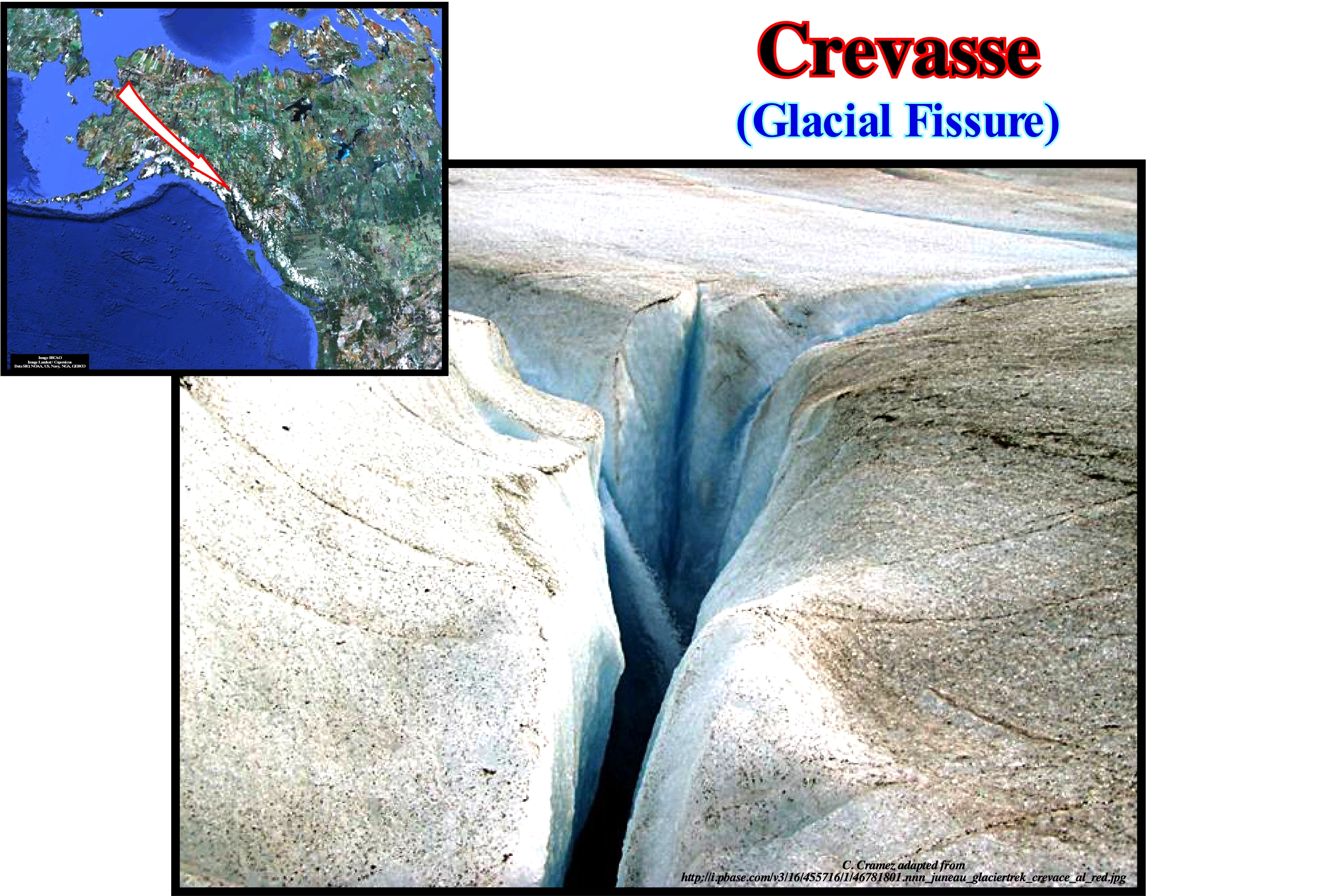
As shown in this photograph of a glacial fissure is a crevasse, more or less, vertical. The depth of a glacial fissure varies greatly. Sometimes it can exceed 100 meters. There are four types of glacial fissures: (i) Transverse Crevasses (as illustrated above) ; (ii) Longitudinal Crevasses, which form parallel to the movement of the glacier where the width of the glacier is expanding ; (iii) Marginal Crevasses, which are oriented diagonally, from the glacier end and upstream, since the glacier velocity is higher in the central part than in the margins and (iv) Detachment Crevasses or "Bergschrund", which separate the part of the glacier that is in motion from of the stationary part and which, in general, extend in depth to the rocky substrate. In a glacial cirque *, the detachment crevasses, which are induced by the rotation movement of the glacier, are located behind the glacier and are, more or less,, parallel to the rock wall. In winter, all crevasses, whether transverse, longitudinal, marginal or detachment (**) are total or partly filled by snow. Many of them are, sometimes, only covered by a thin layer of snow that forms a bridge between the blocks. These bridges are, extremely, dangerous since it is very difficult to predict if the crevasses are or not filled by snow, which means they can be dangerous when used to move from one block to the other. In summer, some of the snow melts and the bridges disappear.
(*) Depression in the form of an amphitheatre produced by glacial erosion on the walls of the mountains or at the beginning of the valleys. It corresponds to the area of accumulation or feeding of the glacier where the mass of compressed snow moves sliding and, in this way, forms, by abrasion, a circular or semi-circular rocky concavity. When the glacier melt, a glacial cirque can be occupied by one or several glacial lagoons. (https://es.wikipedia.org/wiki/Circo_glaciar)
(**) Fissure between the firn (névé) and rocky wall (upstream) formed in a glacial cirque, when the glacier begins to move from the rocky wall in its movement downstream.
Crevasse (Glacial)..................................................................................................................................................................................................Crevasse (Glacier)
Crevasse (fissura, fenda glaciária) / Fisura (grieta glaciar) / Gletscherspalte / 冰隙 / Ледниковая расщелина / Crepaccio /
Fissure, more or less, vertical of a glacier or a firn created by the stresses induced by the differential movement of the ice over a rough surface. Crevasses can reach more than 100m depth, and sometimes, be hidden by snow bridges. In geomorphology, crevasse is, also, used do name the ruptures of banks of a river or channel. Synonym of Glacial Fissure.
See: « Glacier »
&
« Moraine »
&
« Ablation »
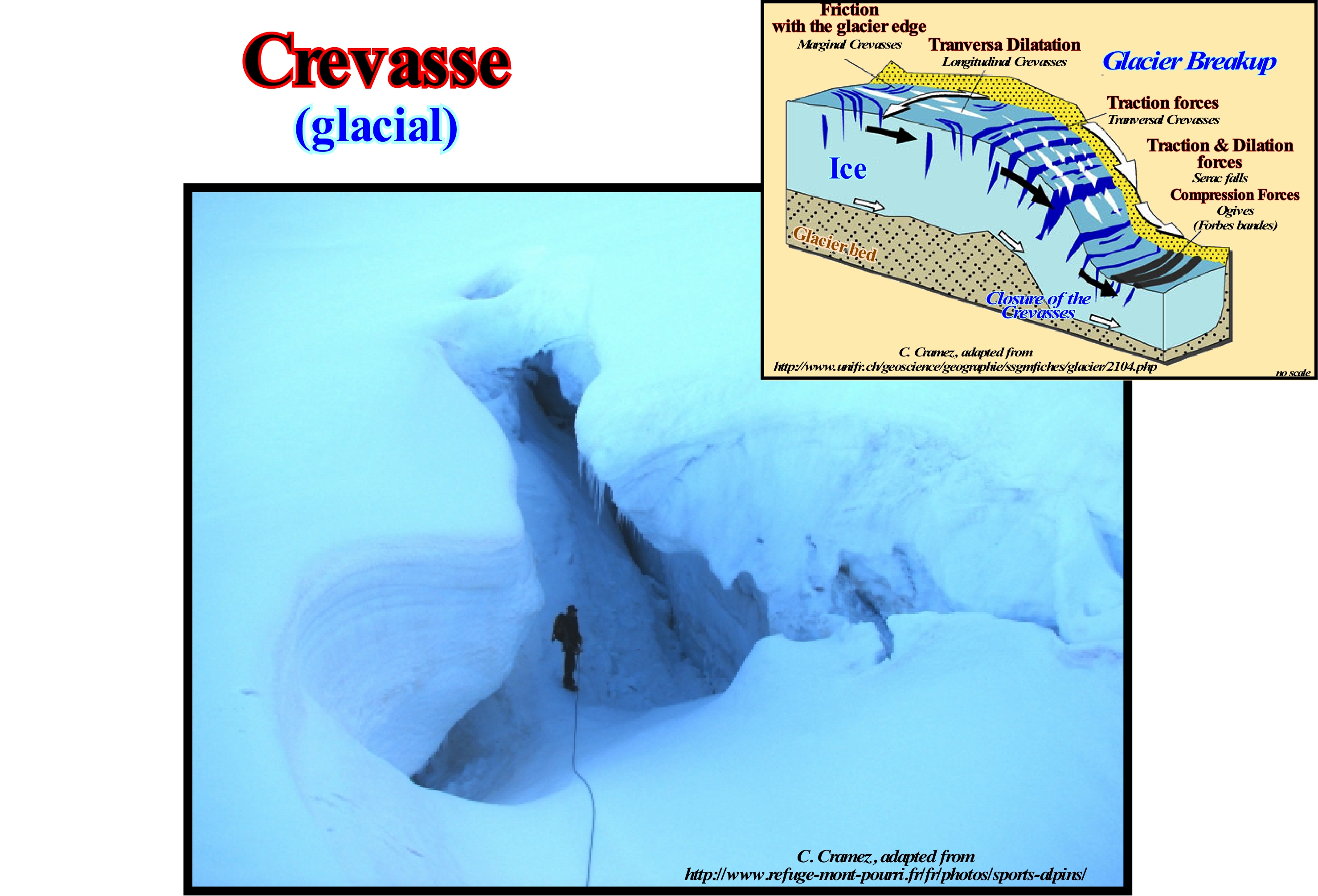
As illustrated in this photograph a crevasse, crevice or glacial fissure is a, more or less, vertical fracture on a glacier. The depth of a glacial crevasse is very variable and can, sometimes, exceed 100 meters. There are four types of glacial fissures: (i) Transverse Crevasses, which form in the extension or enlargement zone (where the glacier accelerates its downward movement) and which are perpendicular to the direction of glacier movement ( open cracks) ; (ii) Marginal Crevasses, which are diagonally oriented, from the glacier end upwards, since the speed of the glacier is higher in the central part than in the margins ; (iii) Longitudinal Crevasses, which form parallel to the glacier movement, where the width of the glacier is expanding and (iv) Detachment Crevasses, which separate the moving part of the glacier from the stagnant part and which may extend to the rocky substratum (depth sometimes exceeding 100 m). In a glacial cirque*, the fissure of detachment is located behind the glacier and is parallel to the rocky wall. This type of fissure appears to be induced by the rotational movement of the glacier. In winter, the detachment crevasses are filled by snow avalanches coming from the top of the mountain. In summer, due to the melting of the snow, the fissures can remain open and can be very dangerous for the climbers. Any glacial fissure can be covered by a snow bridge and thus not fully filled. Using a snow-covered fissure to pass from one side to another can have very serious consequences in that it is very difficult to predict whether or not it is filled. It is the interaction of the efforts on the surface of the glacier that determines, in part, the distribution, orientation, density and extent of propagation of the crevasses.
(*) A glacier of a cirque, which is a part of a glacier, should not be confused with a glacial cirque, which is the circular or semi-circular basin produced by the action of ice on a glacier in its accumulation or feeding zone. A glacier of cirque is a type of glacier that is limited to a basin or cirque of accumulation. It does not have a glacial tongue and has a reduced ablation area due to the low abundance of ice. A glacier of cirque is a mountain glacier. It has, usually, a slightly sloping bottom and may be the result of a thinning process in which the glacier tongue has disappeared. It may also be, in a thickening phase, the stage prior to the appearance of the glacier tongue, when ice accumulation still does not allow the glacier to overflow its cirque (https: //es.wikipedia.org / wiki / Glaciar_de_circo).
Crevasse-Deposit (Crevasse splay)....................................................................................................................Éventail de crevasse
Derrame de fenda / Derrame de ruptura / Crevasse -Hinterlegung / 决口存款 / Конус прорыва прируслового вала / Crepaccio deposito /
Sedimentary body of geometry, usually, lobular, deposited in the floodplain of a river from the water that escaped from the main stream through a crevasse.
See: « Fluvial Deposition »
&
« Flooding-Forestepping»
&
« Flow-Stripping (turbidites) »
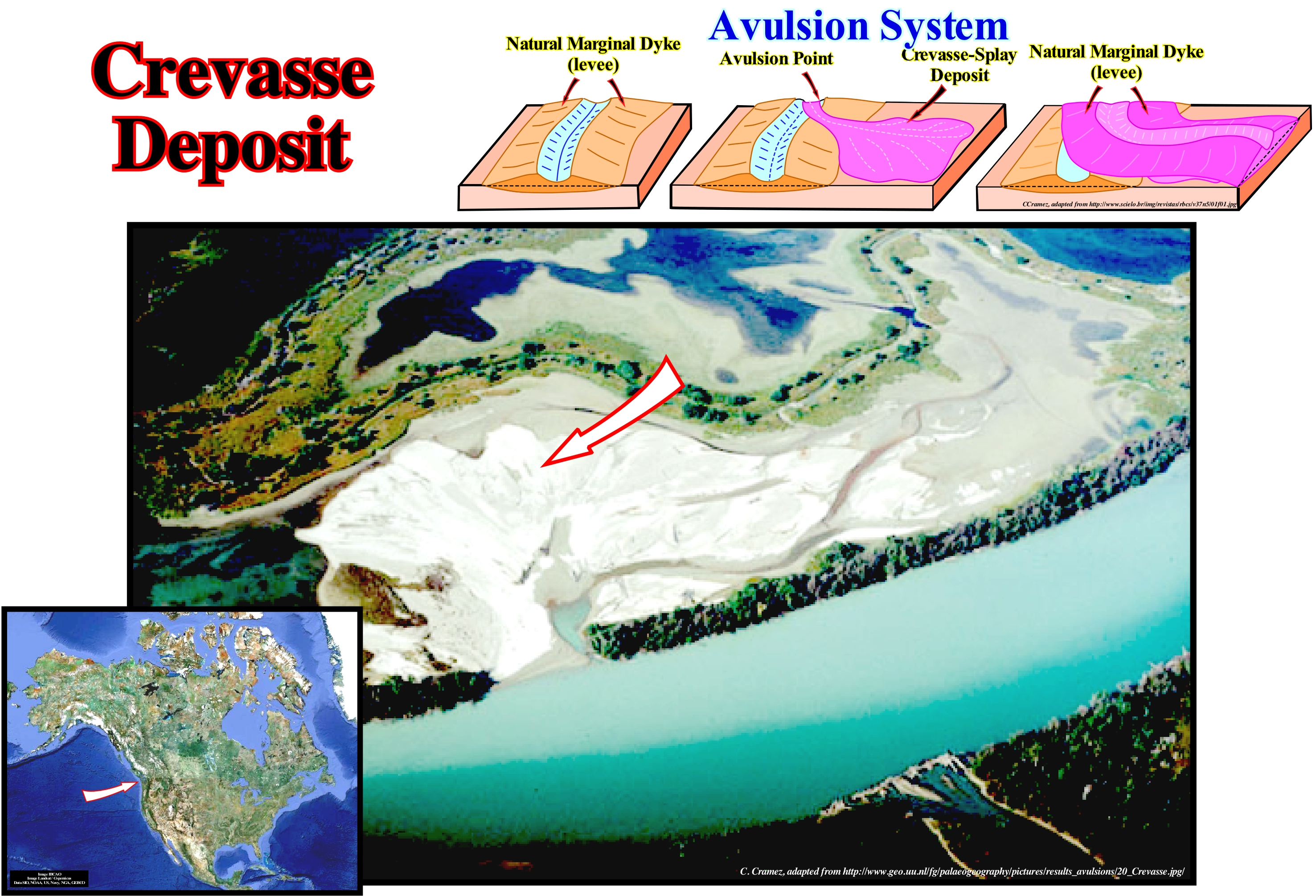
As shown in this figure, a crevasse-splay is a small alluvial fan, which forms in the floodplain of a river, when the stream is, heavily, laden with sediments and breaks one of the river's natural marginal dikes (levees) that creates a fissure of rupture. Although the sedimentary material is, mainly, transported in suspension (silt and clay), coarser material can be transported from the deep part of the water sheet covering the floodplain. Since the velocity decreases, the sedimentary particles deposit. The surface of the spill is, sometimes, characterized by distributaries and braided channels. The granulometry decreases with the distance to the crevasse (rupture fissure). The thicker material deposits closer to the break point of the natural marginal dikes (levees). The sedimentary particles aggradate the top of the crevice and prograde toward the floodplain. The structure of a crevasse-splay is, often, characterized by significant heterogeneity, several floods, deep and surface runoff, and rapid sedimentation. Certain geoscientists define a crevasse-splay as the topography that results, in the local, where a natural (or artificial) marginal dike is ruptured, which usually occurs during a flood. Once the sediment-laden water passes the crevasse (fissure), it disperses the transported sediments into the flood basin to form a sedimentary fan. Function of the discharge amount through the crevasse and the sedimentary load, the components of a crevasse-deposit or crevasse-splay may be different. The most frequent component is the channel or spillway, which tends to form distributive channels from the crevasse fissure as is the case illustrated in this figure. In the crevasse-splay at least four distributive channels may be evident. The two most important, which even form braided strands between which the water is deviated from the main channel, flows parallel to it. In many cases, one can talk about crevasse-splay with different lobes. Crevasse-splay channels may have natural, more or less, sinuous levees formed during flood periods. In general, and contrary to what is illustrated in this photograph, the crevasse-splay are, preferably, formed on banks opposite to the meander point bars (accumulation of silt, sand, gravel, often, unconsolidated, deposited in the loose water in the convex part of a meander), where the geometry is concave and where erosion is most important. Crevasse-splays are, often, more frequent on the side where the natural marginal dikes are deposited, which correspond to aggregation of flood deposits and therefore indicate not only the nature of the sedimentary particles transported but also the flow regimes of the river for periods ranging from 100 to 1,000 years. A detailed sedimentological and lithological study of overbank deposits in the valley meanders of the Mississippi River led to the following conclusions: (1) Marsh deposits, natural margin dikes and crevasse-splays can be sub-divided in lithological units in association with the development of the meander belt ; 2) Avulsion cycles, progradation of the natural marginal dykes, progradation and abandonment crevasse-splay and flooding lamina are preserved in the flooding depressions ; (3) Flood basin facies progradate toward the central part as natural margin dikes overlap, vertically, along the meandering edges. The development of a meander belt is divided into four phases: A) Pre-avulsion phase ; B) Avulsion phase ; C) Early phase of meander belt and D) Late phase of meander belt. In the studied area, the sedimentary interval of the flood basin associated with avulsion and the development of the meander belt (30 m) has a maximum thickness of about 10 m. The avulsion is, probably, recorded in the sedimentary series by a lithological change of blue clay, with organic debris deposited in stationary waters, in flooding silts and sands associated with the development of dikes and crevasse-splay during the incipient formation of the meander belt. Surface natural marginal dykes (silt sand) exhibit a coarsening upward bedding (2.5 m) reflecting the migration of the meander during the late stage of meander belt development. Surface deposits of crevasse-splay (shaly sand), initially, coarsening upward, during the stage of degradation and finning upward when the crevasse-splay is abandoned (3 m).
(*) K. M. Farrell, 1987- Sedimentology and facies architecture of overbank deposits of the Mississippi River, False River Region, Louisiana,The Society of Economic Paleontologists and Mineralogists (SEPM), Recent Developments in Fluvial Sedimentology (SP39), 1987.
Critical Density (Universe)......................................................................................................................................Densité critique (Univers)
Densidade Crítica / Densidad crítica (Universo) / Kritische Dichte / 临界密度 / Критическая плотность / Densità critica /
Number for the average density of the Universe, which will determine if the Universe is closed or open. If the density of the Universe is greater than the critical density, the Universe is closed and its expansion will, eventually, stop. If the density of the Universe is less than the critical density, the retarding effect of gravity will be insufficient to stop the expansion of the Universe, which will continue forever.
See : « Universe (age) »
&
« Big Bang (theory) »
&
« Big Crunch »
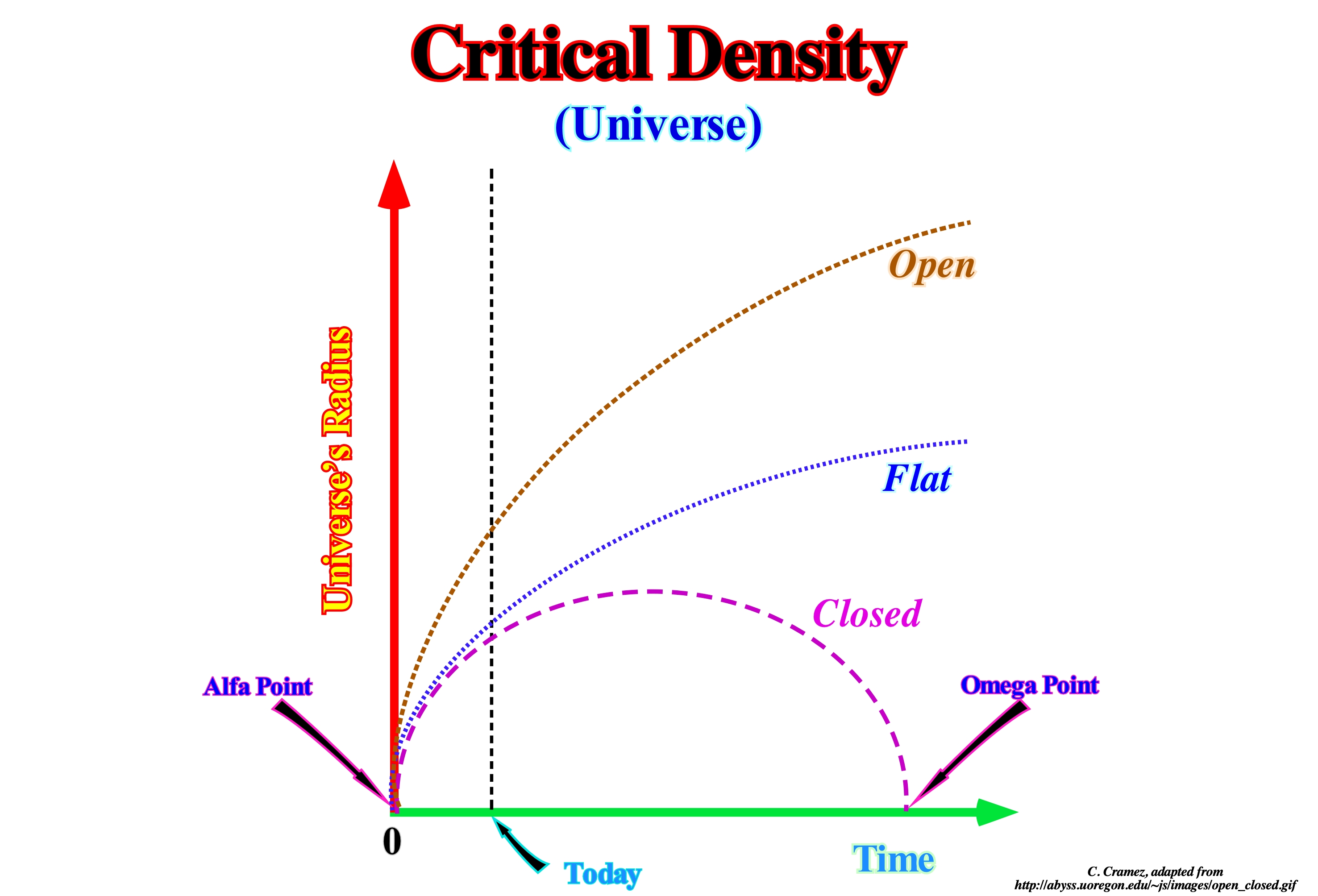
The relativity equations suggest that the curvature of space depends on the total content of matter and energy of the Universe. Similarly, they suggest there is a critical density of matter and energy*, more or less, equal to the mass of five (5) hydrogen atoms, i.e., 10-23 grams per cubic meter, which differentiates the different Universe's types. It seems that the density of the Universe, which is difficult to determine, stipulates whether the Universe will be closed, open or flat. The theory of general relativity says the curvature of the space of an Universe homogeneous and isotope is determined by its content in matter and energy. When the Universe contains, in average, more than the critical density of matter and energy (equivalent to five hydrogen atoms per cubic meter), it is, positively, bent (Closed Universe). To get the critical density, which is, extremely, small (hundreds of billions (109) times less than water density), the cosmological principle* is used. In fact, no one knows if the expansion of the Universe will, in time, begin to slow down and even reverse itself. If that happens, a contraction phase will occur and eventually the Universe will be destroyed by an event analogous to the Big Bang, which the geoscientists called Big Crunch. As illustrated in this figure, three possibilities may occur in the evolution of an Universe: (i) Closed Universe (the Universe contains more than 5 hydrogen atoms per cubic meter i.e., it is, positively, bent) ; (ii) Flat Universe (the Universe contains about 5 hydrogen atoms per m3, which means that their curvature is zero) and (iii) Open Universe (the Universe contains less than 5 hydrogen atoms per m3 and thus, it will have a negative curvature). In the closed Universe hypothesis, the Universe is finite, but it has no limits. In such a Universe, expansion must, eventually, cease and be followed by a phase of contraction. In the hypothesis of a flat Universe, the curvature of the Universe must be zero. Such a Universe would be on the boundary between a closed Universe and open Universe (our Universe is thought to be relatively flat). In the hypothesis of an open Universe, the curvature of space is such that the Universe does not close itself. An open Universe is infinite. It differs from a closed Universe, since expansion never slows down. Certain geoscientists say if our Universe was infinite and eternal (the possibility that there are other universes besides ours can not be scientifically excluded), whatever the direction of observation, we would always see the light of a star and the whole sky would be so bright (during the night or during the day) as the surface of the Sun. That is, even during the day it would be difficult to distinguish the Sun from the brightness of the bottom of the Universe. However, as we all know, at night, the sky is black and there is a medium that separates the stars (or galaxies), which probably means that the Universe, at least at Present, is not infinite and eternal.
(*) The entire observable Universe, of which the Earth is a very tiny part, contains matter in the form of stars, planets, and other objects scattered in space, such as particles of dust, molecules, protons, and electrons. In addition to containing matter, space also is filled with energy, part of it in the form of microwave radiation. Matter itself has energy, called "rest energy." What distinguishes matter-energy from other forms of energy is that all matter has inertia and is subject to the force of gravity when at rest as well as when in motion. Inertia measures the resistance of an object to being accelerated by a force, and the inertia of an object at rest is proportional to its mass. (https://www.encyclopedia.com/environment/encyclopedias-almanacs-transcripts-and-maps/matter-and-energy)
(**) The Universe is homogeneous (similar to itself everywhere) and isotropic (similar to itself in all directions). It is the old idea of the German Cardinal Nicolas de Cues (1401-1464) that no place in the Universe is particular and that its properties are, in average, the same in all places.
Cross-Cutting Relationship...............................................................................................................Relation d'intersection
Relação de intersecção / Relación de intersección / Crosscutting Beziehung / 横切关系 / Теория поперечного разреза / Relazione Intersecanti /
Geological discontinuities suggesting relative ages. A geological event is younger than the event that cuts it. In fact, a fault that cuts a rock is younger than the rock.
See : « Event (geological) »
&
« Fault »
&
« Geological Map »
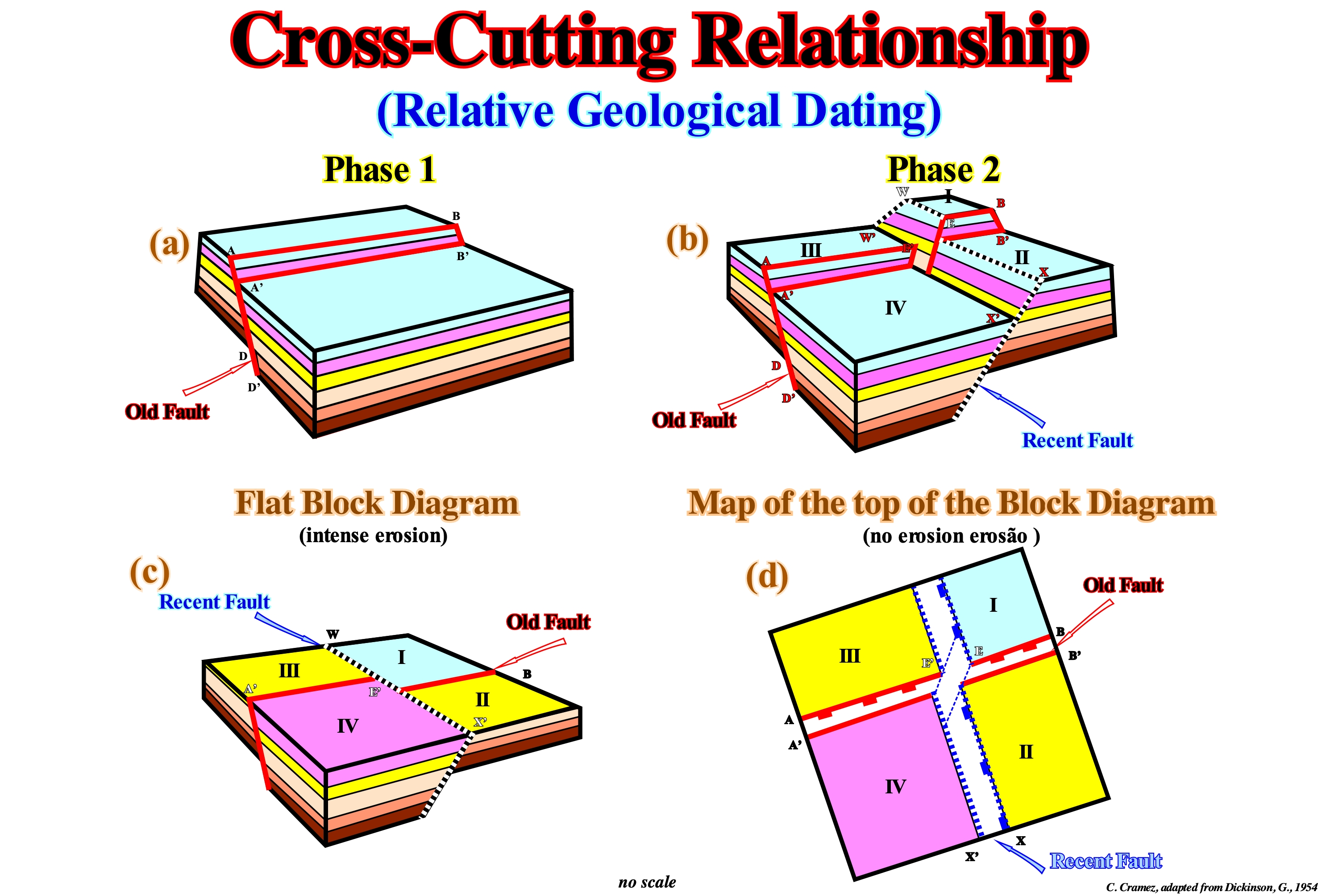
One of the most frequent errors of geoscientists working in oil companies is that they, often, forget the topography when determining the relative age of faulting by the method of intersection relations. A large part of the traps drilled by oil companies are morphological traps by juxtaposition rather than structural traps. In juxtaposed morphological traps, the reservoir-rock, located in a faulted block (generally in the upper block or hanging-wall) is placed in juxtaposition with a sealing-rock (lateral seal) of the opposing faulted block, due to the relative movement of the two blocks along the fault plane. The age of the trap corresponds to the age of the fault or its reactivation. A trap is only interesting if its age is older than the age of migration of hydrocarbons (you can not accumulate oil in a trap that does not exist). Thus, the determination of the relative age of the fault, whose movement creates a trap, is crucial in petroleum exploration. In a block diagram without topography (as shown in the sketch C of the figure above), that is to say, in an area (geological map) with a flat topography, it is the youngest fault (whether normal or inverse), which displaces the oldest. However, since there is a, relatively, important topography, which is the case in most geological and seismic maps in isochronous (time lines), it is the most recent fault that is, apparently, displaced by the oldest fault (do not forget that there are no normal vertical faults). In the example illustrated above, during Phase 1 (Cretaceous) a normal fault striking N 45° (azimuth) was formed. It dips toward N 135°. It produced an important sinking of the lower block. During the Miocene (phase 2), another tectonic regime, in extension, created a normal fault striking N 310° and dipping toward N 220°. This fault produced, also, an important sinking of the bottom block. In the surface map of the block diagram (without erosion, in D) it is, apparently, the recent fault that is displaced by the old fault, which is not the case when the topography is flat (C).

