
Reserves (Minerals)......................................................................................................................................................................................Reserves (Minérales)
Reservas / Reservas (minerales) / Reserven (Mineral) / 储量(矿物) / Резервы (минеральные) / Riserve (minerale) /
Part of the resources (amount of a mineral or existing or undiscovered rock that may possibly be a day extracted, but which today can not be extracted for economic or technical reasons) of a particular mineral or rock (such as oil) that can now be extracted from the ground with profit.
See: « Resources »
Reservoir (HC)........................................................................................................................................................................................................Reservoir (HC)
Reservatório / Reservorio (HC) / Reservoir (HC) / 水库工程, 水库(慧聪) / Залежь (УВ) / Reservoir (HC) /
Any porous and permeable rock that contains oil or gas. Sand, sandstone, limestone, dolomite, etc. are the most common reservoir-rocks, but important accumulations of hydrocarbons are also frequent in fractured rocks (granite, quartzites, etc.).
See: « Oil Pool (hidrocarbons) »
&
« Arenite »
&
« Hydrocarbon »
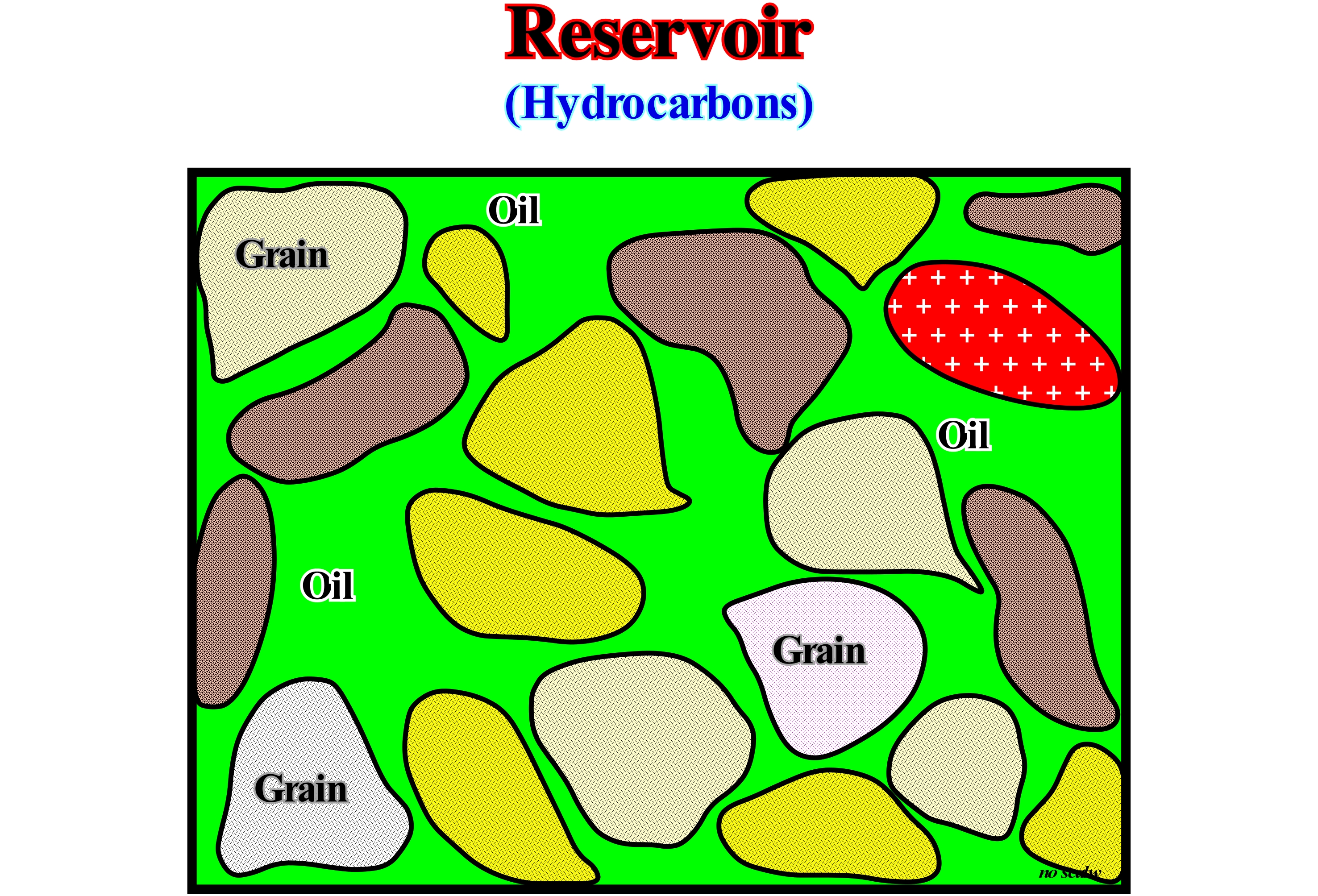
The oil generated by a source- rock will only be useful if it accumulates within a reservoir-rock in a trap. Not all rocks have the possibility of storing oil or gas. For this to be possible it is necessary that the rock has free space between grains, which constitute it, i.e., that the rock has a certain porosity. A rock with these characteristics, like a sandstone or like certain limestones, is called reservoir-rock or simply reservoir. In this very schematic figure, it is illustrated a reservoir-rock, not compacted, seen under the microscope, in which are distinguished grains with different compositions (internal pattern) and the areas between them, that is, in the pores, where oil can be found. In this particular case, in which the porosity is filled by heavy oil, it is obvious that it is the oil that keeps the sedimentary grains in suspension, since they do not touch. If by chance, the oil is produced, most likely, and the rock-reservoir is compacted, the grains approach each other until they touch. This event can produce a subsidence of the ground surface to the vertical of the accumulation (tat the condition that it is not a great depth). This type of subsidence is, very often, observed in mature oil sedimentary basins, such as Venezuela onshore, either on the banks of Lake Maracaibo or in Maturin geographic basin, or in the south, near the Guyanas craton , that is to say, in the Orinoco oil belt ("Faja de Orinoco"). A rock-reservoir must also be permeable. The pores have to be connected with each other, so that the hydrocarbons, which are in the pores, can seep out and be extracted from the reservoir-rock. If the pores are not connected between them (non-open system), the reservoir-rock has no permeability and the hydrocarbons are stored there forever. A good rock-reservoir should be porous (> 10%) and permeable (k> 1 mD) so that oil production can be profitable.
Reservoir-Rock.......................................................................................................................................................................................Roche-réservoir
Rocha-reservatório/ Roca reservorio / Lagerstättengestein / 储集岩 / Коллекторная порода / Roccia serbatoio /
Any porous, permeable rock that contains oil or gas. Sand, sandstone, limestone, dolomite, etc. are the most common rock-reservoirs, but important accumulations of hydrocarbons are also frequent in fractured rocks. Synonym with Reservoir.
See: « Trap »
&
« Sealing-Rock »
&
« Source-Rock »
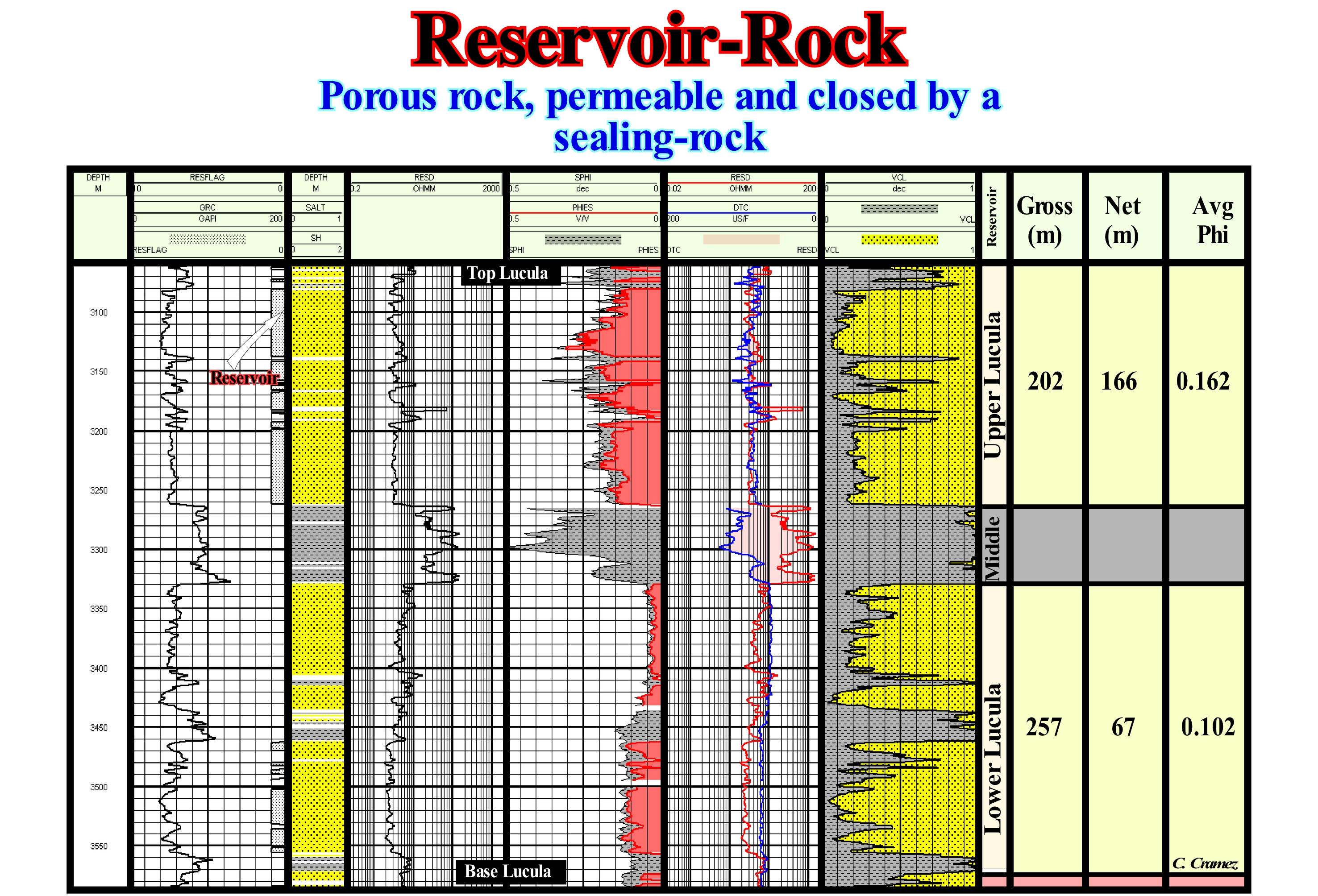
In this figure is illustrated the interpretation of interval with rock-reservoir characteristics of Cabinda onshore (Angola), based on the study and correlation of the electric logs and the analysis of lateral cores. The Lucula formation, which is an important reservoir interval, can be subdivided into three sub-intervals: (i) Lower Lucula, with rock-reservoir characteristics, despite the presence of a clay interval rich in organic matter, that can be considered as an alternative source-rock interval ; (ii) Middle Lucula, made up of clayey rocks and which can be considered as an interval of sealing-rock and (iii) Upper Lucula, which consists of sandstones and which is the reservoir interval by excellence. Within the reservoir intervals, not all strata have reservoir-rock-reservoir characteristics. It is important to differentiate the gross and effective reservoir interval. The thickness of the gross reservoir of the Upper Lucula is about 202 meters, while the actual reservoir thickness is only 166 meters. In the Lower Lucula, the gross reservoir thickness is 257 m, but the actual reservoir is only 67 m. This differentiation is important since, prior to the explorations wells, the geoscientists, based on the seismic data, are, eventually, able to calculate the total thickness of the Lucula, but due to the seismic resolution, they have no idea of the thickness of the effective reservoir. In addition to the actual reservoir thickness, geoscientists have to calculate the porosity and average permeability of the reservoirs. A rock-reservoir has to be permeable. The pores have to be connected with each other, so that the hydrocarbons can move and be extracted from the rock-reservoir. If the pores are not connected between them (not opened system), the reservoir-rock is not permeable and the hydrocarbons are stored there forever. A reservoir-rock must be porous (δ> 10%) and permeable (k> 1 mD) so that oil production can be profitable.
Resources...............................................................................................................................................................................................................................Ressources
Recursos / Recursos / Ressourcen / 资源 / Ресурсы / Risorse /
Amount of a mineral or existing or undiscovered rock that may possibly be a day extracted but that for economic or technical reasons, can not currently be mined. All that could turn into reserves if there were no technological and economic constraints. Resources can turn into reserves when technology, financing, time and economics are favorable.
See: « Oil Pool (hidrocarbons) »
&
« Reserves »
&
« Unproven Reserves (HC) »
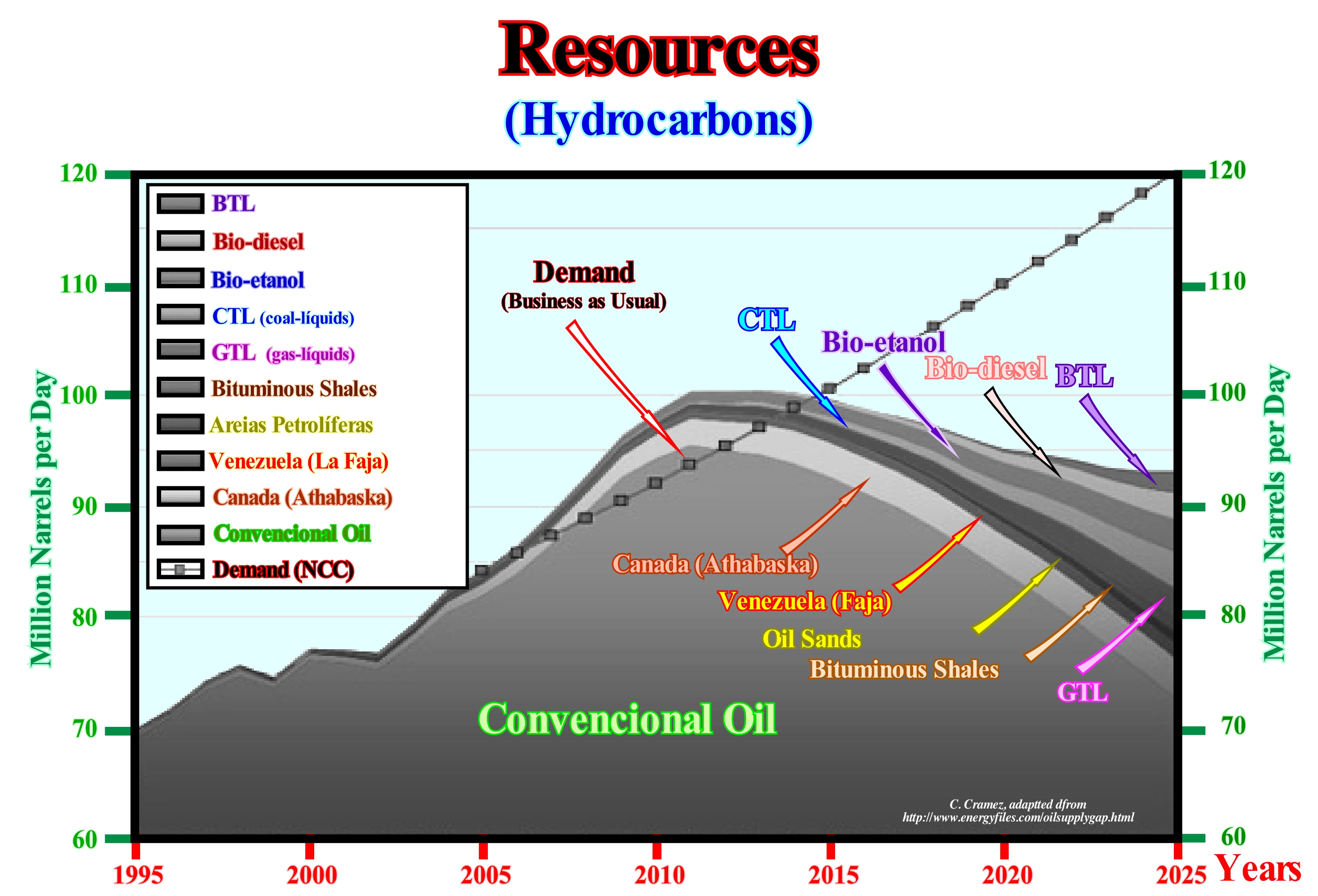
Time magazine said that the Athabasca (Canada onshore ) bituminous shales could contribute to and largely full-fill the demand for fossil fuels during this century. As illustrated above, by combining all possible resources and other forms of oil production with conventional oil, the set will be largely insufficient if demand continues as before, i.e. "Business as Usual". The so-called "oil shales" of the Athabasca can produce a lot of oil, but, probably, such an oil production will create a major environmental problem and certainly can never nullify the difference between supply and demand for fossil fuels, which is already beginning to make itself felt. This is true even if the problems of return on investment and the need to use gas and water for oil production are, effectively, overcome. The Orinoco Belt (Venezuela onshore), where several oil companies have been producing light oil from very heavy oil for some years now is, often, considered to be the region with enough resources to save us. However, the oil production, in this area, is, largely, dependent on the subsidence of the ground surface as the oil is extracted, which is now, totally, beyond the control of the geoscientists working in the area. Anyway, even the production of light oil in the Orinoco Belt reaches 1 Mbd (1 million barrels per day), i.e., 365 Mb per year, which is not the case, the energy problem will be far to be solved, since current world consumption (2010) is about 29 Gb (29 billion barrels). On the other hand, the time required to develop these resources is too long to help solve the energy problem in the short term.
Restored Section...............................................................................................................................................................................Coupe restaurée
Secção restaurada / Sección restaurada / Restauriert Abschnitt / 恢复部分 / Палеоразрез / Sezioni bilanciata, Sezione restaurata /
Geological section ignoring all deformation and erosion of sediments and thus showing the thickness and lithology, immediately, after sedimentation or, more correctly, after compaction.
See: " Formation (geological) "
&
" Geological Section "
&
“ Depth Section (seismic) ”
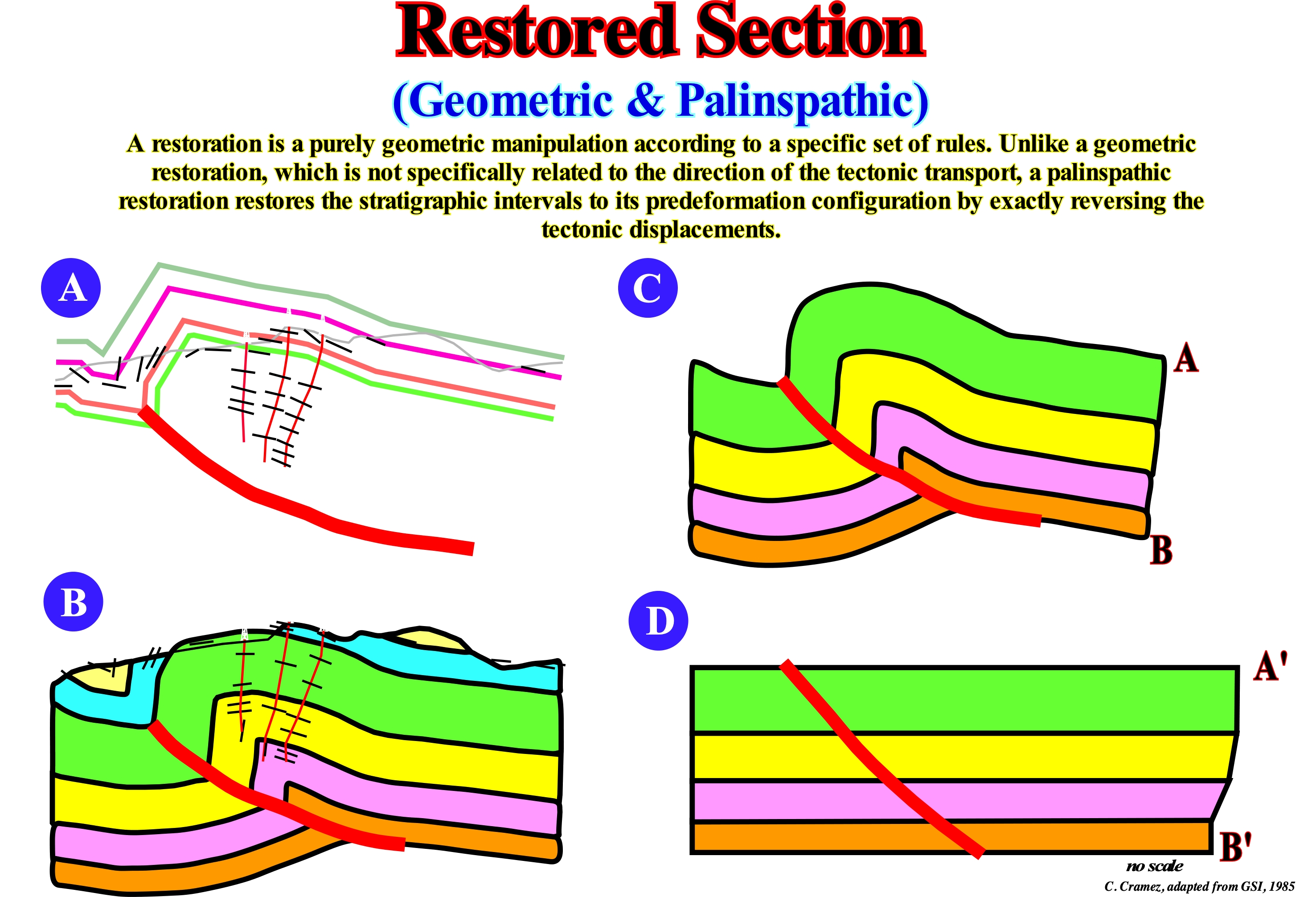
The balanced geological sections can be tested by palinspathic reconstitutions. The balancing of a geological section is a selective test of natural scale restoration, that is to say, 1:1 scale (field scale). Geological sections can be made using a computer and based on seismic data, subsurface (electrical diagrams) and surface, as shown in this figure. The result can be based on the geometry of deformation by flexure, by sliding or in other methods. All structural interpretations must comply with Goguel's law (the sediment volume must be, more or less, constant during deformation, taking into account the volume reduction by compaction and dissolution), i.e., they must be equilibrated or balanced. There are, at least, four kinematic models for restoring geological sections (either field or made from the geological interpretation of seismic lines (in depth): (i) Fault-Bend-Fold method ; (ii) Rotation of Rigid Blocks ; (iii) Vertical and Inclined Shears and (iv) Flow parallel to the faults (ftp://ftp.ufrn.br/pub /biblioteca/ext/bdtd/AlexFA_Cap9_ate_final.pdf). The first method assumes that the deformation of the beds is accompanied by flexural sliding along the stratification planes which function as sliding surfaces where the deformation between the layers is minimal. The rigid block rotation restoration (does not apply to areas with folded structures) preserves the lengths and original internal angles, and is applicable to failed sections with undeformed blocks, as found in domino-like structural styles. In curvilinear faults*, the collapse of the lower faulted block can be idealised by linear homogeneous displacements along the vertical or inclined sliding planes at an angle to which a series of points located in the lower block are translated parallel to the regional dipping line. The flow parallel to failure method consists of moving material points in the faulted block along lines parallel to the main fault. In this figure, the geological section, in which the presence of an reverse fault is obvious, was constructed using the results of the dipmeter logs of three exploration wells and the field observations. During restoration, unfolded sediments should be placed along the fault plane without any voids (lack of sediment) or overlaps (extra sediments) occurring. Nature has a horror of empty spaces. Some balancing programs, such as the one used in this example, use the kink software, in which the main problems are: (i) The location of the top of the lower faulted block (footwall) and (ii) The determination of the trajectory of the fault plane and internal geometry of the lower faulted block. The initial data are taken from the interpretation of the slope diagrams of the exploration wells and the geological cuts made in the field. The profiles of the wells are perpendicular to the direction of the layers so that the slopes are real. Using the slope projections, a horizon is constructed through the three wells and other data. Its geometry is projected up and down to construct three or four horizons that are extended to the top of the upper block. The section obtained can be, easily, modified and restored until the law of Goguel is respected. Taking the final section (D) and horizontalizing the top of a sedimentary interval, one can see whether the law of Goguel ** was respected or not, and whether the slope of the fault plane is compatible with Anderson's theory (reverse faults dip, more or less than 30 °, normal faults dip, more to 60° and strike slip faults, dip more or less to 90 °, however, normal low-angle thrusts and faults of low-angle are exceptions to this rule). On tentative geological interpretations of seismic lines a very particular attention must be paid to the picking of fault planes and in particular to their dip,which can give valuable indications and be used as an interpretation refutation test.
(*) Many geoscientists call the curvilinear faults as listric faults. Etymologically, a listric fault corresponds to a fault that in the upper part has a normal movement (lengthening), while in the lower part, it has an reverse movement (shortening). The sliding fault of a road slope or of other landslide, is a fault, which is a particular case of a curved fault: all listric faults are curvilinear, but not all the curvilinear faults are listric.
(**) During deformation, the volume of the sediment remains, more or less, constant. This hypothesis, although very old, took a very important place in geology with the works of Goguel (1954), who introduced the second principle of thermodynamics in geology and in particular in tectonics. This principle is approximate. It does not take into account the volume reduction induced by the decrease in porosity in depth and the phenomena of dissolution, which in some cases may reach about 30% of the total volume.
Restricted Circulation Shelf & Tidal.........Plate-forme à circulation restrictive et plaine de marée
Plataforma de circulação e planície de maré / Plataforma de circulación restringida y planicie de marea / Plattform Bewegung und restriktive Gezeiten-Ebene / 受限水流的大陆架和潮汐滩地 / Платформа с ограниченной циркуляцией и приливно-отливной отмелью / Piattaforma à movimento restrittivo e pianura di marea /
Distal sedimentary environment of a rimmed carbonated platform between the lagoon of platform with open circulation and the evaporites in sabkhas salines.
See: « Rimmed Carbonate Platform »
&
« Drowned Carbonate Platform »
&
« Monocline Carbonate Platform »
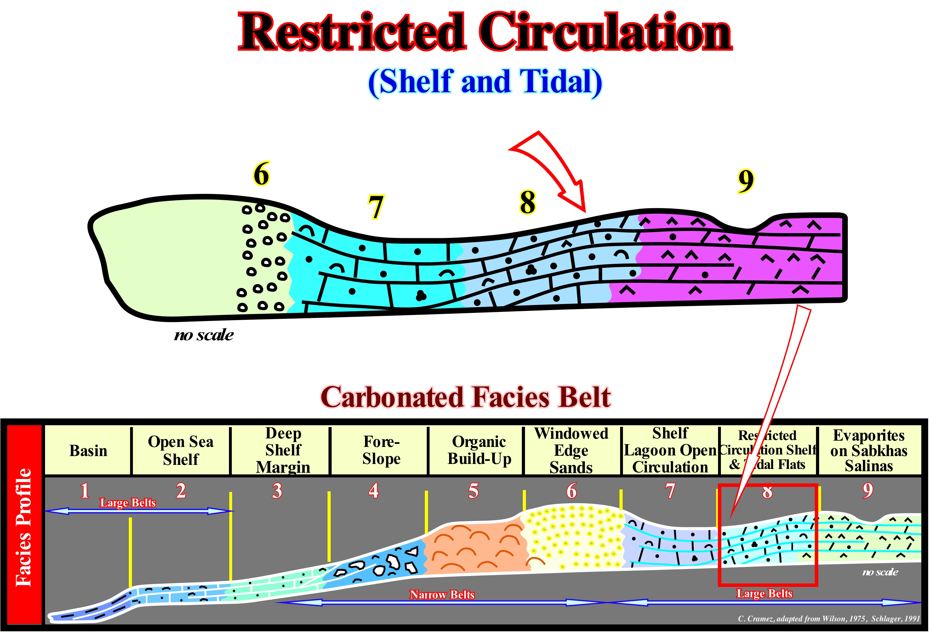
Under normal geological conditions, the water-depth of a limestone platform can not exceed the depth of the photic zone, otherwise carbonate formation (photosynthesis) can not occur. A carbonated platform may coincide with a continental shelf but, in general, this seems to be an exception. A continental shelf, whose water-depth varies between 0 and 200 meters, is a physiographic province, which forms part of the continental margin morphological structure (submarine extension of the continental block) whereas a carbonate or carbonate platform is a sedimentary body that has a topographic relief and that is composed of calcareous deposits that were formed "in situ", i.e., autochthonous calcareous deposits. Several geoscientists have observed the occurrence of a typical sequence of sedimentary and, more or less, constant environments between the basin and the mainland (when the platform is connected to the mainland) in the carbonate platforms and, particularly, in trimmed or fringed carbonate platforms. This succession of carbonate sedimentary environments is illustrated in this figure and can be considered as a platform model. Although it does not say anything about the differentiation, often found between leeward and windward margins (platform not connected to the continent), that is, on the asymmetry of the platform. In this model nine sedimentary environments are distinguished: (i) Basin; (ii) Open Sea Shelf ; (iii) Deep Shelf Margin; (iv) Fore-Slope ; (v) Organic Build-up ; (vi) Windowed Edge Sands ; (vii) Shelf Lagoon with Open Circulation ; (viii) Restricted Circulation Shelf and Tide Flats and (ix) Evaporites on Sabkhas Salinas. The restricted circulation platform and tidal plain is located upstream of the platform lagoon with open circulation and downstream evaporites on sabkhas salinas. It is located under the action of the waves, in calm sea, but is reached by the action of the waves during the storms. The geological context is that of a, more or less, flat platform within the photic zone and usually above the action of the waves in a calm sea but less connected to the sea than the open-circulation platform lagoon. Variations in temperature and salinity are frequent and the sediments are mainly limestone, clay sand and sometimes clean sand. A diagenetic cementation is very common, as is a significant terrigeneous influx. The biota is of shallow water with little diversity but, in general, with a great number of species. Miliolide foraminifera are typical of this sedimentary environment. Most of the geoscientists consider five categories of carbonated platforms: A) Rimmed Platforms, which are characterized by the presence of reefs or calcareous sands of shallow (carbonated sandbanks covered by shallow sea-water) on the edge of the platform and clay sands in the lagoon or on the open platform (this type of platform forms in calm waters and its extension varies between 10 and 100 km) ; B) Ramp Carbonated Platforms , in which the carbonated sands of the coast line pass, at the base of the ramp, to clay sands and deep water sludge (in this type of platform the reefs are rare and the width of the ramp can reach 100 km) ; C) Epeirial (or epíric) Platforms, which are characterized by the presence of tidal surfaces and protected lagoons ( the width of an epeiric platform can reach 10,000 km) ; D) Isolated Platforms, in which the facies (lithologies) are very controlled by the orientation of the prevailing winds and E) Dead or drowned platforms, when they are under the photic zone (where there is not sufficient light for photosynthesis, i.e., use of carbon dioxide, CO2, and water to obtain glucose through the energy of sunlight). Isolated platforms have reefs and sandy bodies, such as the rimmed platform, in the windward margin, i.e., facing the side where the wind blows, but in the leeward margin, i.e., in the direction where the wind blows, the sediments are more muddy. An isolated platform can reach 100 km wide. The most well known carbonate platform geometry is associated with tropical manufacturing processes, where carbonate platforms can be subdivided into three main sedimentary environments: A) Reef, which is the part of the carbonate platform created in situ by sessile organisms ; B) Lagoon, i.e., part of the platform behind the reef, which is characterized by shallow and calm waters with sediments composed of fragments of reefs and hard parts of organisms or terrigeneous sediments when the reef is epicontinental and C) Slope or Reef Slope, i.e., the external part of the platform that connects the reef to the basin and acts as a sink for the excess carbonate sediment, although most of the sediments produced in the lagoon and reef are transported by various processes and accumulated in the slope.
Resurgence (Stream)......................................................................................................................................................................Ressurgence (Courant)
Ressurgência / Resurgencia (de corriente) / Resurgence (ein Strom) / 中兴(电流) / Выход подземных вод на поверхность / Risorgimento (di una corrente) /
Place where a stream of groundwater reappears on the surface of the ground after disappearing upstream. It is said of the waters of a river that, made subterranean, for a certain length, reappear on the surface of the ground.
See: « Source (stream) »
&
« Water Table »
&
« River »
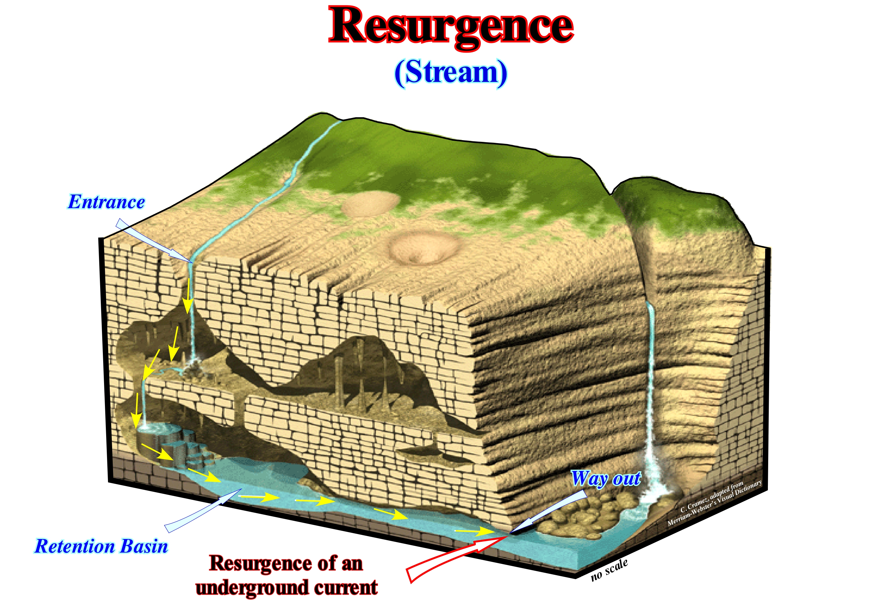
Resurgences are, especially, common in limestone regions. In these regions, the internal circulation of water takes place between points of entrance (or absorption), which may be fractures, faults, potholes, etc., whereby the subaerial currents disappear and the way out points which, in general, are called resurgences. Certain subterranean paths, as illustrated in this diagram, can be tested by water colouring. The elderly inhabitants of the town of Pontarlier (a French town located in the department of the Jura, near the border with Switzerland) still remember the colouring of the Doubs river resurgences caused by the contamination of absinthe when the fire of Pernod factory (aniseed manufacturer). Obviously, in practice, it was not the absinthe that coloured de river-water but fluorescein (a manufactured organic compound ans dye, available as a dark orange/red powder slightly soluble in water and alcohol, which is, widely, used as a fluorescence tracer for many applications). A great majority of the waters disappear without being able to show their point of resurgence, as if they were lost in a deep towel or, directly, in the bottom of the sea. Between the entrance and the way out points, the path of the underground stream is, totally, independent of the layout of the old surface rivers. There is no underwater current under the canyons (subaerial or submarine). The directions of the underground currents, sometimes, cut off those of the missing subaerial currents. The underground path is made by holes and galleries, whose sections differ according to which the stream flows freely, that is to say, by gravity with interposition of air to the normal pressure between the water and the vault of the galleries, or overpressure in which the geoscientists they call wet vaults. In the first case, the sections of the galleries are very variable and the rooms with stalactites are very frequent. In the second case, the profile of the galleries is, more or less, elliptical, since they are modelled by dissolution. These galleries, where water circulates overpressure may present against slopes and siphons, which sometimes create intermittent resurgences.
Retrogradation (Backstepping)..............................................................................................................................................Retrogradation
Rétrogradação / Retrogradación / Degradierung, Stichgenaues / 退积 / Явление обратной конденсации (обратный процесс) / Retrocessione /
Continentward displacement of the depositional coastal break (roughly, the shoreline) of the depositional surface within the transgressive interval (TI), during the accelerated relative sea level rises (marine ingressions). A retrogradation is, usually, associated with a succession of increasingly smaller progradational sedimentary episodes. It occurs every time a progradational unit does not develop beyond the preceding progradational unit. A retrogradation indicates a series of increasingly important marine ingressions (relative sea level rises) and increasingly smaller sedimentary regressions, with no relative sea level falls between them (eustatic paracycles).
See: « Transgressive Interval »
&
« Systems Tract »
&
« Relative Sea Level Rise »
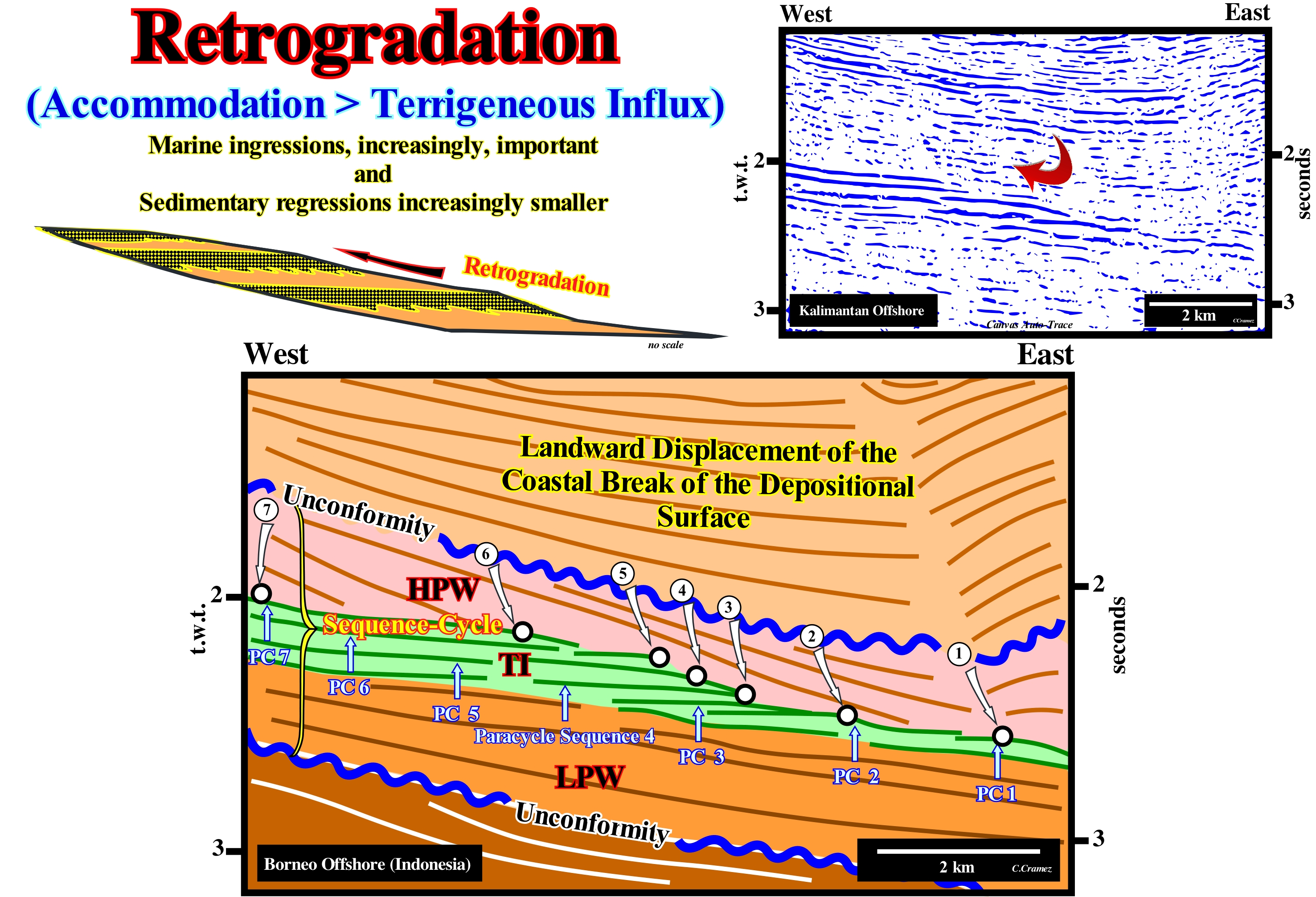
Within a sequence-cycle, the relative sea level rise (sea level, local, referenced to any fixed point of the Earth's surface, whether it be the base of the sediment or the seafloor and that is the result of the combined action of absolute or eustatic sea level* that initiates the group of highstand systems tracts (GHST), induces a continentward shift of the depositional coastal break (more or less, the shoreline, especially on the seismic lines, i.e., taking into account that the seismic resolution is in 2D seismic lines around 30/40 meters) on the slope of the depositional surface. Such a displacement of the shoreline creates or increases the continental shelf and the water-depth, as the rise in relative sea level is in acceleration (increasingly important marine ingressions). The rise in relative sea level is not in continuity. Many geoscientists speak of composite marine ingression and single marine ingressions. Single marine ingressions are steps of a composite marine ingression, since a relative sea level rise is, in the majority of the cases, done in steps, as, for instance: (i) Rise in relative sea level of 3 m (single marine ingression) ; (ii) Stability period in relative sea level ; (iii) Relative sea level rise of 5 m (single marine ingression) ; (iv) Stability period in relative sea level ; (v) Relative sea level rise of 7 m (simple marine ingression) ; (vi) Stability period in relative sea level ; (vii) Fall in relative sea level of 10 m (marine regression). In this case, globally, the relative sea level rose 15 meters (composite marine ingression) in acceleration, since single marine ingressions are increasingly greater. The terms single and composite marine ingression should be used whenever clarification is required. The first relative sea level rise, i.e., the first single marine ingression (first eustatic paracycle), is followed by a stability period of the relative sea level, during which the shoreline and the associated coastal deposits move to the seaward, as the sediments prograde towards the continental edge, which is now also the edge of the basin. However the shoreline does not reach the position it had before (retrogradation). Thus the first paracycle-sequence is deposited. The second relative rise in sea level (second single sea ingression), i.e., the second eustatic cycle, which is more important than the first, as the relative sea level rises in acceleration, again, shifts the shoreline landward increasing the extension of the platform and the water-depth. A new period of relative sea-level stability allows, again, the displacement of the shoreline seaward and the deposition of progradational sediments (second sequence-paracycle), but without the shoreline reach the position it had in the end of the preceding sequence-paracycle, which, globally, corresponds to a retrogradation as illustrated in this tentative geological interpretation of a auto-trace of a detail of seismic line from Indonesia offshore. This mechanism (relative sea level rise - stability of the relative sea level - relative sea level rise) continues until the first rise, in deceleration, in the relative sea level (smaller than the previous one), which initiates the deposit of the highstand prograding wedge (LPW). What certain geoscientists, incorrectly (in our opinion), call transgression or the displacement to the continent of the shoreline and associated coastal deposits, is nothing more than a succession of ever larger single marine entrances and increasingly, more and more, sedimentary regressions small. It is this set of marine ingressions and sedimentary regressions, which globally has a retrogradational geometry, which Cesare Emiliani (1992) called "Transgressions" (not transgression). The internal configuration of sequence-paracycles is progradation. Between consecutive eustatic paracycles there is no relative sea level fall. Sediments are deposited during the stability period of relative sea level that occurs between two eustatic paracycles. In other words, between two eustatic paracycles there is any erosional surface (unconformity), but, just, a ravinment surface. On this tentative geological interpretation of an auto-trace of a detail of a seismic line from Borneo offshore, within the considered sequence-cycle, limited by two unconformities (in blue), it is easy to recognize the sequence-paracycles, which here correspond to sedimentary systems tracts, which form the lower subgroup of highstand systems tracts called Transgressive Interval (TI). It is possible that in this particular case, each sequence-paracycle corresponds to a unique sedimentary systems tract. The retrogradation of the depositional coastal break of the depositional surface (chronostratigraphic line), which corresponds, more or less, to the retrogradation of the coastline, is obvious.
(*) Global sea level, referenced to the centre of the Earth. The relative sea level is the result of the combined action the global sea level and tectonics (subsidence of the sea level, when the extensive tectonic regimes are predominant or uplift, when the compressive tectonic regimes are predominant.
Retrogressive Sandstone...........................................................................................................................................Grès rétrogressif
Arenito retrogradante / Arena retrogradante / Rückschrittlich Sandstein / 倒退砂岩 / Регрессивный песчаник / Arenaria retrogressiva
Sandstone deposited in sequence-paracycles of the transgressive interval (TI) of a sequence-cycle. Individually, each sequence-paracycle translates a regressive sedimentary episode. However, collectively, in the transgressive interval (TI), they form a globally retrogradant ensemble, due to a sedimentary influx that becomes insufficient due to the creation and increase of extension of the continental shelf induced by a rise in relative sea level in acceleration (increasingly important marine ingressions and increasingly smaller sedimentary regressions). In retrogradational sandstones, progradations and oblique stratifications, with a seaward vergence (indicate the orientation of the terrigeneous influx), are predominant, since the great majority of clastic sediments come from the land and not from the sea.
See: « Systems Tract »
&
« Relative Sea Level Change »
&
« Transgressive Interval »
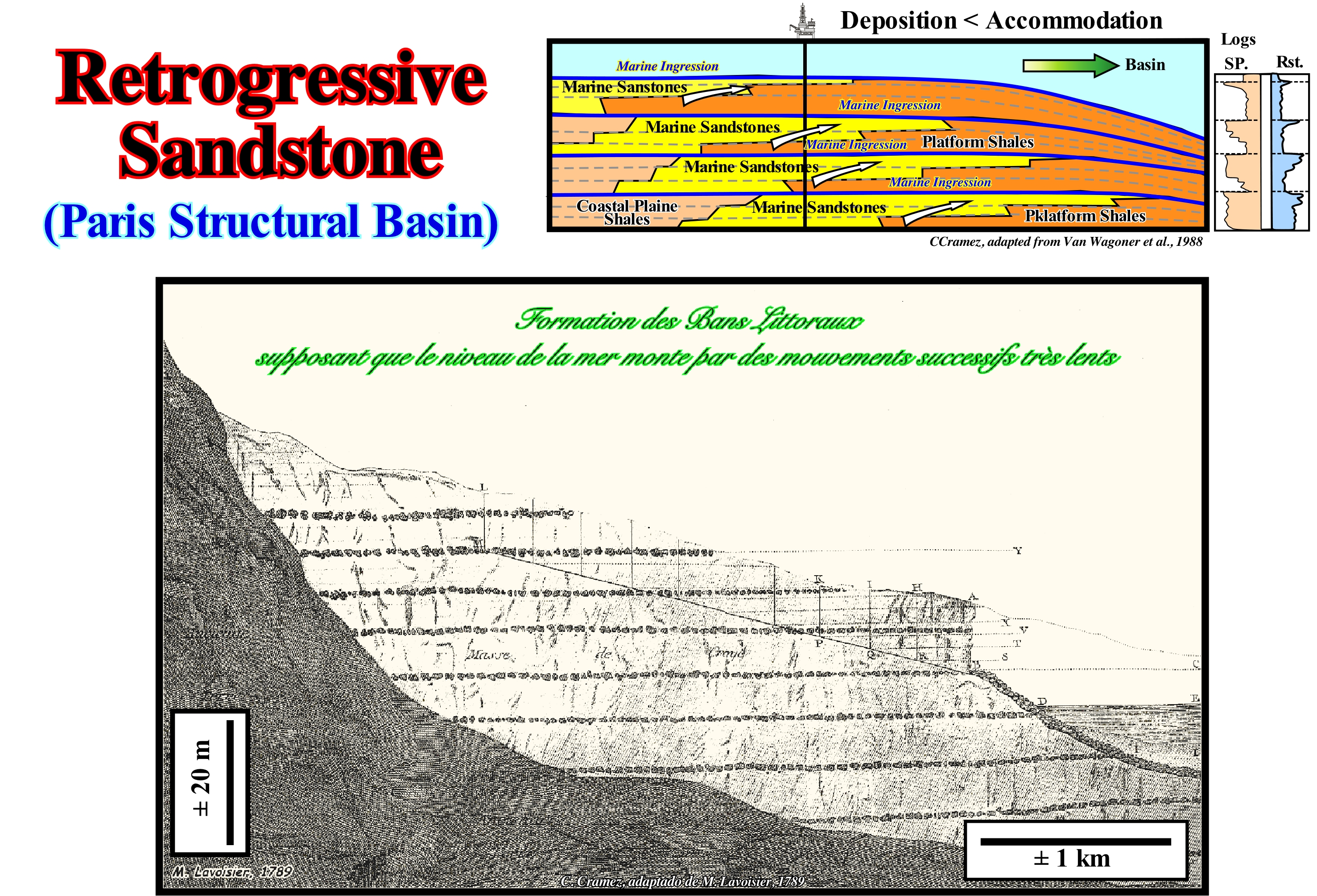
Antoine Laurent de Lavoisier (1789) was, after the French ambassador to Egypt, De Maillet*, one of the first scientists to consider, what is now called eustasy (variations of absolute or eustatic sea level, i.e. variations of the supposed global sea level referenced to the Earth's centre), as the main factor of the cyclicity of the sedimentary deposits. Lavoisier interpreted the coastal sandstones of the Paris structural basin as retrogradational sandstones deposited in association with successive relative sea level rises, which are now called marine ingressions or transgressions. As shown in this figure, the geometry of these sandstones, strongly, suggests a continentward displacement of depositional coastal break of the depositional surface (more or less, the shoreline on the seismic lines) at each relative sea level increment. In sequential stratigraphy, a relative sea level rise,, marine ingression and eustatic paracycle are synonymous. Sediment deposited between two consecutive sea level rises (without relative sea level fall between them), i.e., during the stability periods of relative sea level, which occurs after each eustatic paracycle, are bounded by two ravinment surfaces. They form what is called a sequence-paracycle, which, generally, has an progradational internal configuration and is formed by one or more sedimentary systems tracts (lateral association of different depositional systems, i.e., a characteristic lithology and fauna, which are, more or less, equivalent to a facies **, synchronous and genetically linked between them). At each marine ingressions, i.e., at each continentward displacement of the shoreline, induced by a relative sea level rise, a small erosional surface that geoscientists call the ravinment surface, is developed on the preexisting topography. What many geoscientists call, in a rather abusive way, a "transgression" *** corresponds to the set of marine ingressions increasingly important (accelerating relative sea level rises) and the associated increasingly smaller sedimentary regressions, which are deposited during the stability periods of relative sea level between marine ingressions. It was to such a set of increasingly important marine ingressions and increasingly smaller sedimentary regressions that, globally, create a retrogradational geometry that Ceasare Emiliani (1992) called transgressions and not transgression. As illustrated in the geological sketch, a sequence-paracycle can never be considered as a transgression, since several sequence-paracycles are required to, collectively, develop a retrogradational geometry, if the deposition rate is lower to the accommodation rate. It is the vertical succession of increasingly smaller sedimentary regressions, due to the deficiency of the terrigeneous influx, that creates the retrogradtional global morphology characteristic of transgressive deposits. At each relative sea level rise, the depositional coastal break of the depositional surface moves continentward, which increases the area of the continental shelf. During the stability period of the relative sea level, which follows a relative sea level rise, the terrigeneous influx displaces depositional break seaward. However, due to a deficiency of the terrigeneous influx, the shoreline does not reach the position it had before the relative sea level rise. This insufficient progradation of the shoreline is repeated at each stability period of relative sea level. Many years ago, at the University that I attended, students were taught that: "When the sea transgresses, the sands regress, and that is why a sedimentary transgression is simply a set of less important sedimentary regressions."
(*) Benoît de Maillet was born on 12 April 1656 in Saint-Mihiel (Meuse) and died on 30 January 1738 in Marseilles. He was consul of France in Egypt and inspector of the French settlements in the Levant. He is the author of a clandestine work -Telliamed- (pallet of "de Maillet") that greatly influenced the naturalists of the Enlightenment, such as Darwin and Lamarck and broke the myth of the biblical flood.
(**) Armanz Gressly's original definition of facies (E. Wegmann, "The original exposition of the notion of facies by A. Gressly (1814-1865)", in Sciences de la Terre, 9, 1963, 83-119), corresponds, basically, to a lithology and its associated fauna. However, at present, many geoscientists consider facies as a rock body with specific characteristics, which can be any attribute observable in it, such as its composition, training conditions and changes that can occur in these attributes in a geographic area.
(***) A transgression is an invasion of the lands by the sea. However, certain geoscientists use this term to denote the overall displacement of coastal deposits seaward, which is very different from the original definition of transgression. It is certainly, to avoid confusion that others the expressions "marine transgression", "sedimentary transgression" or "marine ingression" are almost always used.
Reverberation..................................................................................................................................................................................................Réverbération
Reverberação / Reverberación / Nachhall / 混响 / Реверберация (отражение) / Riverberazione /
When the seismic rays of a marine emitter are reflected several times between the bottom and sea level. This multiple is of all multiples, that are found on seismic lines, the easiest to eliminate in the processing of seismic data. Synonym with Ringing.
See: « Diffraction (seismic wave) »
&
« Seismic Ray »
&
« Reflection Seismic »
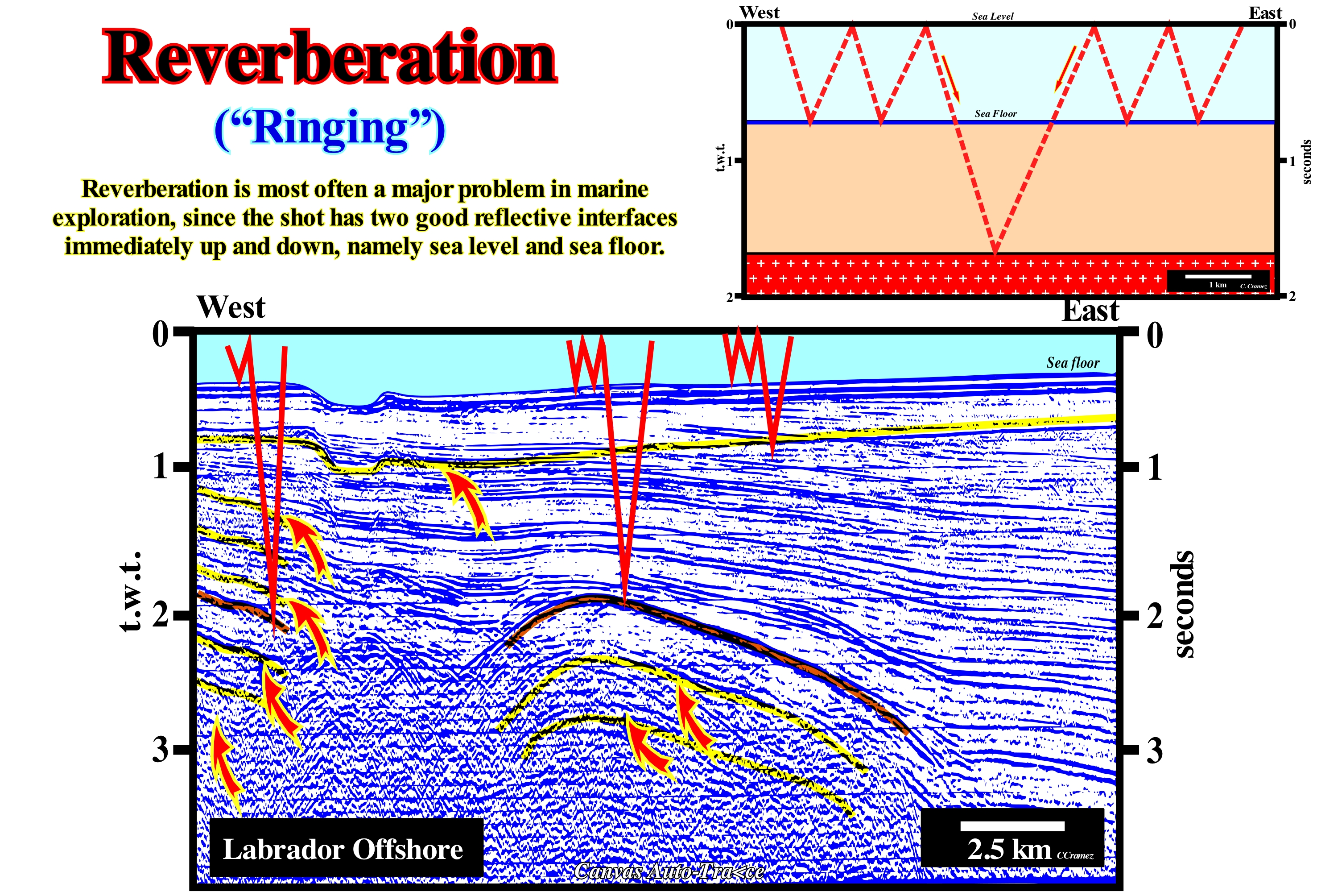
Reverberation or ringing is a seismic resonance* produced by the small wavelength multiples induced by the water-depth. Although the reflection seismic method relies on the simple path hypothesis, as illustrated in this sketch, complex reflected arrivals are, often, recorded (multiples). In this particular case, the repeated paths within the water-depth are added to the depth horizon travel time. This multiple type produces coherent noise or resonance ("pedalage" in French ). It is very frequent on the seismic lines and can be found, sometimes, on onshore seismic lines. As illustrated, it is due to the multiple reflections in the water-depth. When in a seismic line, a reflector resembles the morphology of the seabed, it must be imperatively tested, since it may have no geological significance. The strong reflection coefficients at the surface and at the base of the water-depth cause repeated reflection of a large part of the energy. For certain water-depths, particular frequencies are reinforced and the registers present a sinusoidal shape. Thus, not only the delineation of the reflections, but also the timing and curvature corrections, are subject to errors. To avoid this kind of multiple, geoscientists use an inverse filter, i.e., they send a resonance through the reverse filter (at a treatment centre) to the outlet of the hydrophone that suppresses the effect of the water-depth. A deconvolution, i.e., the convolution process with a reverse filter is one of the most important seismic treatment operations. The deconvolution** allows to suppress the resonance of the water-depth, but may also deconvolve with other filters, to suppress other effects, to the sufficient condition to be known about the filters and the signal. Convolution is a mathematical operation in which two functions a and b, which produce a third function, which is typically considered as a modified version of one of the original functions.
(*) A phenomenon which occurs when a vibrating body is subjected to the action of a periodic force whose period of vibration approaches the period of vibration characteristic of that body in which a relatively small force applied repeatedly causes the amplitude of the oscillating system to become very great.
(**) Mathematical operation used to restore signals to recover data that has been degraded by a physical process that can be described by inverse operation to a convolution (linear operator that, from two functions, results in a third one that measures the sum of the product of these functions to the overlapping them as a function of the displacement between them).
Reverse Polarity (Magnetism).................................................................................................................Polarité inverse (Magnétisme)
Polaridade inversa / Polaridad inversa (magnetismo) / Verpolung (magnetisch) / 极性反向(磁) / Полярности (магнитный) / Polarità inversa (magnetismo) /
Geological time interval during which, in the past, a magnetic needle pointed to the south pole, i.e., a time interval with a polarity of the Earth's magnetic field different and opposite to that of today.
See: « Magnetics »
&
« Polar Wandering »
&
« Radiomaetric Dating »

The position of the earth's magnetic field changes with time. At present, the north magnetic pole is close to the Earth's North Pole, a geological condition, which is called normal polarity. The periods of time during which the magnetic north pole was located near the Earth's South Pole are called periods of inverse polarity. The determination of the different polarities is possible since when the lavas solidify in the mid-oceanic ridges, the iron-containing minerals are oriented according to the terrestrial magnetic field, i.e., they register, so to speak, the orientation of the magnetic field at the moment they solidify. In an erratic way, roughly, every 500 ky, the Earth's magnetic field changes polarity, spending perhaps a few thousand years to disappear and reappear in the opposite direction. In association with the oceanic expansion (sea floor spreading), from the mid-oceanic ridges, oceanic crust bands were formed with different magnetization, as indicated in the sketch shown in this figure. This allowed geoscientists to establish a magnetic stratigraphy based on the times of normal and inverse polarity. In overlapping the great magnetic epochs there are small periods of inverse polarity, known as, magnetic events, which can last between a few thousand years and 200 ky. The rocks that currently form on the crest of the mid-ocean ridges are, usually, magnetized as they solidify during the present magnetic polarity, which is considered normal. However, do not forget that the magnetized rocks, corresponding to the magnetic epoch that occurred about a million years ago, were displaced from a certain distance from theridgel. If the oceanic expansion was 2 centimeters a year, these rocks will now be about 20 km on each side of the ridge, or 40 km if oceanic expansion is 4 centimeters per year. Using this principle, geoscientists have determined that the strongest ocean expansion rate is in the eastern part of the Pacific Ocean, where it is about 10/12 cm per year, while in the Atlantic it is only 2 cm per year.
Reynolds' Number............................................................................................................................................................Nombre de Reynolds
Número de Reynolds / Número de Reynolds / Reynolds-Zahl / 雷诺数 / Число Рейнольдса / Numero di Reynolds /
A dimensionless number derived from velocity, length and viscosity that determines whether a fluid flows smoothly or turbulently.
See: « Flux (flow) »
&
« Turbulent Flow »
&
« Debris Flow »
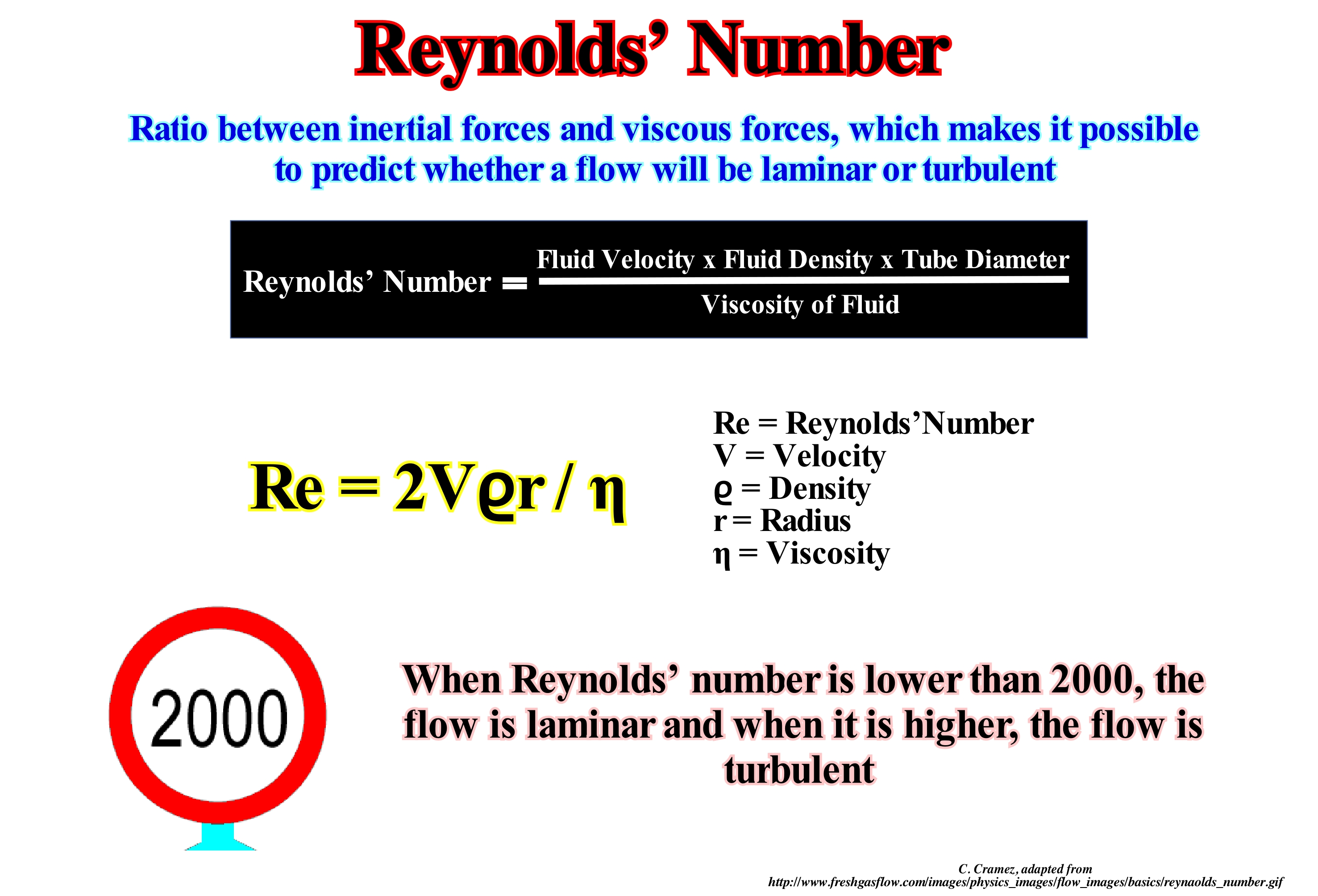
The Reynolds coefficient, number or modulus (abbreviated as Re) is a dimension number used in fluid mechanics for calculating the rate of flow of particular fluid over a surface. It is used, for example, in industrial piping projects and aircraft wings. Its physical meaning is a force quotient: inertia forces (vρ) and viscosity forces (μ/D). It is expressed as: Re = (ρd)/μ, where v is the mean velocity of the fluid, D the characteristic longitude of the flow, d the diameter for the flow in the tube, μ the dynamic viscosity of the fluid and ρ the specific mass of the fluid quotient between mass and volume of fluid. The fundamental meaning of the Reynolds' number is that it allows to evaluate the type of flow (flow stability) and can indicate whether it flows in laminar or turbulent form. For the case of a flow of water in a cylindrical tube, the values of 2,000 and 2,400 are allowed as limits. Thus, for values less than 2,000 the flow will be laminar, and for values greater than 2,400 the flow will be turbulent. Between these two values the flow is considered to be transitory. The Reynolds' number forms the basis of the behaviour of real systems, by the use of reduced physical models. A common example is the aerodynamic tunnel where forces of this nature are measured in wings models of airplanes, automobiles, buildings, etc. It can be said that two systems are, dynamically, similar if the Reynolds' number is the same for both. D, that is., the characteristic length of the fluid, generally, refers to any dimension of the system, for example the wing rope of an airplane, the length of a ship, the height of a building, etc. Normally, by experimental values, it is customary to characterize a laminar flow fluid with Re <2,100 and turbulent flow with Re> 4000. All bodies are lazy and do not wish to modify their state of movement. If they are on the move, they want to keep moving. If you are standing, you want to stand still. This laziness is called inertia and is characteristic of all bodies with mass.
Rheic Sea........................................................................................................................................................................................................................Mer de Réique
Mar Reico (Mar de Reia) / Mar de Réique / Rheic Meer / 大黄海 / Реический океан / Mare Rheic /
Sea formed in Late Cambrian / Early Ordovician by lengthening and breakup of "terraneas" or microcontinents of the northern margin of the Gondwana small supercontinent , such as Avalonia, Carolina, etc. This sea closed, completely, in Carboniferous as a result of the continent/continent collisions, which formed the Pangea supercontinent. The expansion of the Rheic Sea took place as Iapetus Sea closed, due to the collision between the Gondwana and Laurasia (rotating episode of the Pangea formation) small supercontinents. The term Rheic comes from the Greek Rhea (daughter of Uranus and Gaia, wife of Jupiter and sister of the Titans). It can be said that in the Paleozoic, the Rheic Sea had an older brother, which was the Iapetus Sea.
See : « Supercontinent »
&
« Rodhinia »
&
« Iapetus Sea »
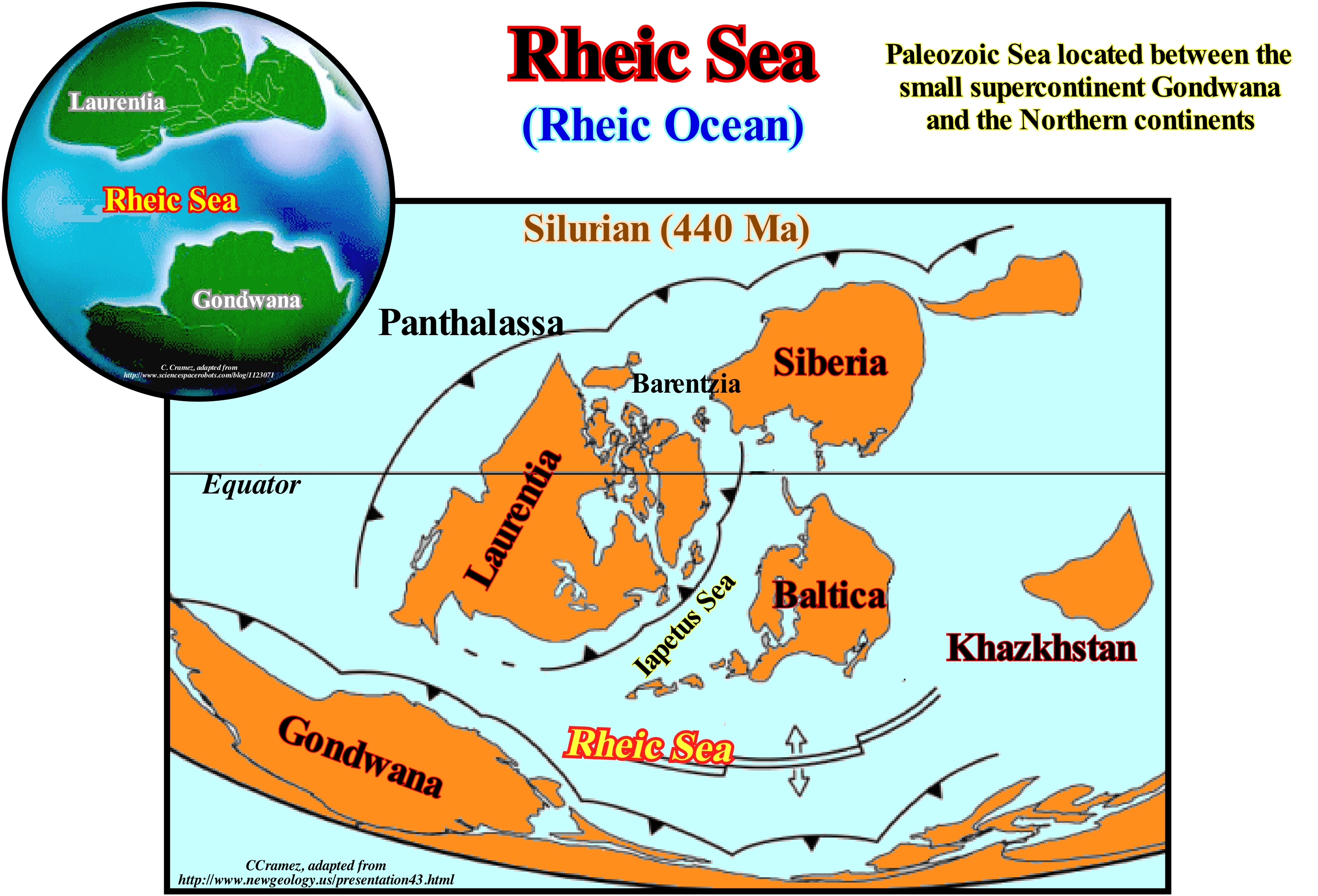
In the Early Cambrian, the ocean located between the Gondwana small supercontinent and the Laurentia continent, was called Iapetus, which in Greek mythology was the father of Atlas. The Iapetus Sea is considered to be the predecessor of the Atlantic Ocean. In the Late Cambodian/Early Ordovician, the ocean between the Gondwana small supercontinent and the Laurussia continent (set of Laurentia and Baltic continents and the micro-continent Avalonia*), was called Rheic Sea, since in Greek mythology, Rhea was the sister of Iapetus. The rise of the mountains created by the Caledonian orogeny put most of England above sea level and created an important terrigeneous influx. England (Laurentia) was situated in the south of a desertic belt, in which the arid sediments were predominant. When the Caledonian orogeny ended, the southern part of England was, again, affected by a compressional tectonic regime (shortening), that closed the Rheic Sea, which existed between southern Europe (Laurasia small supercontinent) and North Africa Gondwana supercontinent). The closing of this sea, which corresponds to the collision of Africa and South America with North America and Europe, was one of the final stages of the formation of the Pangea supercontinent. Around 400 Ma, the Rheic Sea played a very important role in the history of the Earth, since as it closed, the Appalachian mountains and the Variscan Belt (mountains between Southern Europe and North Africa, from Ireland to the Czech Republic and from Morocco to the Black Sea) rose, as the continents, as a result of the breakup of the Protopangeia (or Rodhinia) supercontinent , were increasingly approaching to at the end join and form the Pangea supercontinent. The formation of the Pangea supercontinent was accompanied by a great eustatic fall, that is, an absolute or eustatic sea level fall, which is referred to the Earth's centre, since the volume of the ocean basins diminished once that many ocean ridges disappear along the type B subduction zones (assuming that the total volume of water in all its forms has been constant since 4.5 Ga, i.e., since the Earth's formation). Geoscientists summarize the evolution of the Rheic Sea, more or less, as follows: (i) Breakup of the Gondwana small supercontinent, which forced Avalonia (a Paleozoic microcontinent formed from a volcanic arc on the northern margin of the Gondwana small supercontinent) to be compressed, the Iapetus Sea (a sea that existed between 600 and 400 million years ago, between the Neoproterozoic and Paleozoic periods and which formed due to the separation of the Protolaurasia **), in the beginning of the Middle Ordovician, opening behind the Rheic Sea ; (ii) During a large part of the Late Ordovician, the oceanic expansion of the Rheic Sea occurred at the same speed as the present east Pacific seafloor spread, i.e., about 17 cm / year ; (iii) At the end of the Ordovician, when the Baltic and Laurentian continents collided, to form the small supercontinent Euroamerica (Laurasia), the Rheic Sea had already increased, greatly, due to the oceanic expansion, replacing the Iapetus Sea, which at that time was nothing more than a simple narrow channel between the microcontinent Avalonia and the Laurentia continent ; (iv) The Rheic Sea began to close in the Devonian, when the Gondwana small supercontinent drifted into the Euroamerica small supercontinent (Laurasia) ; (v) At the end of the Devonian, the Rheic Sea became a narrow ocean between the Gondwana and Euroamerica small supercontinents ; (vi) In the Early Carboniferous, the eastern part of the Rheic Sea had already closed because of the collision of East North America with Africa ; (vii) Later, South America collided with the South of North America, completely, closing the ocean, creating the Appalachians and Variscan orogenies.
(*) The Avalonian microcontinent developed from a volcanic arc on the north bank of the small supercontinent Gondwana, where a rift seems to have occurred that has set a microcontinent adrift. Behind him formed the Rheic Sea, compressing the Iapetus Sea in front of it. Avalonia collided with the Baltic continent, then with the Laurentia continent and, finally, with the small supercontinent Gondwana, ending up within the supercontinent Pangea.
(**) The Protolaurasia (what it means before Laurasia) is an old supercontinent, that comprised of the previous supercontinents (Rodhinia and Pannotia). When Pannotia departed to the southeast part formed the small supercontinent Protolaurasia, located near the South Pole and covered with ice. At the end of the Proterozoic, there was a rotation to the West and small supercontinent Protolaurasia began to move away Proto-Gondwana shifting through the Panthalassa. During the Paleozoic, the Protolaurasia departed which originated the continents Laurentia, Baltica and Siberia, forming two other oceans between the three continents: (i) Iapetus Sea between the Laurentia and Baltica ; (ii) Khanty Ocean between the Baltica and Siberia.
Rhythmite.....................................................................................................................................................................................................................................Rythmite
Ritmito / Ritmita / Rhythmite (Offensichtliche Periodizität) / 韵律 / Регулярное наслоение осадочных пород / Rhythmite (periodicità evidente) /
A glaciolacustre complex, laminated, of silt-clayey lithology, formed a pair of sedimentary intervals, one clear and one dark, which is separated from the other rhythmites by a sedimentary discontinuity. Locally, isolated blocks of varying size (centimetric or decimetric) from the producing basin can be found that have fallen from floating ice. Sometimes synonymous with Varve.
See: « Turbidite »
&
« Reservoir-Rock »
&
« Deposition (clastics) »
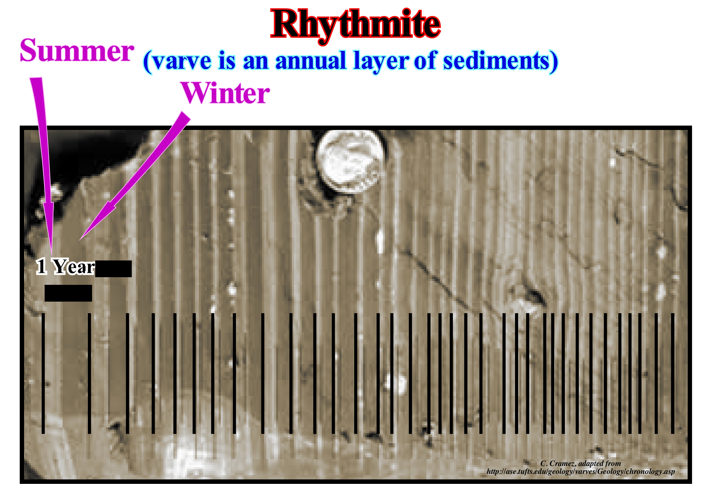
A rhythmite consists of layers of sediment or sedimentary rock that deposit with an obvious periodicity and regularity. Rhythmites can be created by annual processes, such as: (i) Annual processes, associated to seasonal variations that underline the variations in the water-cycle ; (ii) Shorter processes, such as tides or (iii) Longer processes, such as periodic flooding. Rhythmites play an important role in understanding prehistoric events, elucidating variations in sea level, glacial and orbit variations, which answer questions about climate change. Laminated annual deposits known as varves are rhythmic with annual recurrence. The annual layers of sediments or sedimentary rocks are deposited according to seasonal variations resulting from precipitation or temperature influencing precipitation rates and debris loads in runoff water. Many of the rhythmites found in the geological record, the varves are of the most important. They enable us to better understand the climate change changes of the near geological past. Varieties are, certainly, geological events with finer stratigraphic resolution. Rhythmites may be deposited with periodicities other than annuals. Geological records show more frequent events (as, for instance, the tides) and less frequent events (glacial floods) than the varves. In all geological ages, geoscientists have identified deposits induced by tidal currents. Certain Carboniferous layers underline events induced by the tides, such as semidiurnal, diurnal or syzygy tides. The geological record has laminated layers comparable to those currently found in the coastal sediments of Canada and France.
Ria (Coast).................................................................................................................................................................................................................................Côte avec rias
Ria / Ría / Riaküsten / 海岸线, 以利雅 / Риасовый берег / Costa a ria /
Sea extend, relatively, long and narrow, penetrating inland, resulting from the invasion by the sea of the downstream part of a fluvial valley. A ria is a coastal inlet resulting from the submersion of the terminal sector of the hydrographic network of a river basin.
See: « Shoreline »
&
« Littoral »
&
« River »
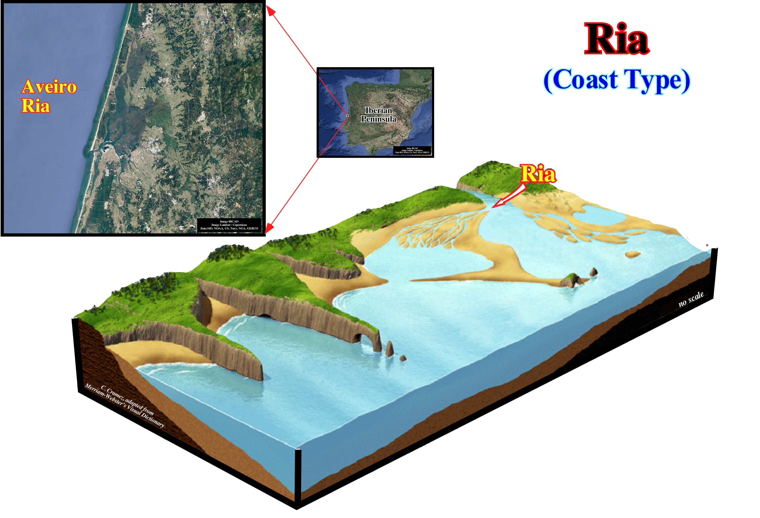
As illustrated, in general, a ria is never formed in isolation, but in groups. Most often a geoscientist speaks of a ria, such as the Aveiro ria (photographs), he is referring to a set of parallel estuaries on the coast of a large territory. A ria forms and when the level of the sea rises and floods a valley of a river. The result is almost always an estuary, surrounded by hills that once formed the valley. A ria is, sometimes, known as the submerged river valley. It can be said that a ria begins as a simple valley of a river that flows between the mountains or mountains that delimit it. As during the last ice age, there were many rivers near the ocean, when sea level began to rise due to the thaw, it began to flood the valleys around the mountains. After some time, the valley is full of sea-water and the river still runs in it. The combination of ocean water and river forms an estuary. A river has a V-shaped channel and many small rivers join it. As a ria is an estuary-type, estuarine species are abundant, although this varies function of geographic location. A ria and a fjord are very similar and can often be confused with one another. A fjord is formed by the glacial movement, whereas a ria is formed by a valley that is flooded by the high tide. Another difference is that a ria is deeper and wider towards the mouth and while the fjords have a shallow mouth. If the hypothesis of global warming, whether anthropogenic or not, is confirmed, which does not seem to be the case, since many geoscientists have found stability, even seeing a decrease in global temperature since 2000, it can, significantly, affect the global environment in the decades to come. If some of the glaciers melt, the sea level will rise, and certainly more rivers will be formed, but the present backs of rivers, contrary to what many people think, have not suffered great damage.
Ridge-Push (Oceanic ridges).....................................................................................Poussée due aux dorsales océaniques
(Constrangimento (dorsais oceânicas)/ Constreñimiento (por las dorsales oceánicas) / Schub durch ozeanischen Rücken / 推力由于洋脊 / Давление горных хребтов / Spinta dovuta alla dorsali oceaniche /
Pressure exerted by ocean ridges and descending lithospheric plates. It is associated with: (i) Horizontal compression resulting from elevation differences between the oceanic expansion center and the ocean floor and (ii) The stress effects of an oceanic lithospheric plate originated by downward movement along a subduction zone of Benioff.
See: « Subduction Zone »
&
« Plate Tectonics Theory »
&
« A-type Subduction (Ampferer) »
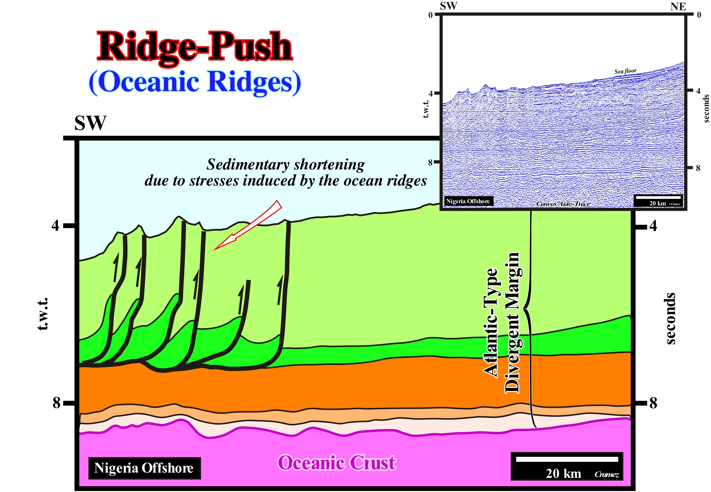
The distal offshore of Nigeria (water-depth greater than or greater than 2,000 meters) corresponds to an Atlantic-type divergent margin of the classification of the sedimentary basins of Bally and Snelson (1980), which covers, directly, the oceanic crust. To the east of this area, in the proximal part of the divergent margin, the rift-like basins, which lengthened the lithosphere of the Gondwana small supercontinent, are visible beneath the margin, as well as, the huge antiform structures, associated with normal, curved faults, which characterize the lengthening (extension), down-dip of the divergent margin. In the deep part of this offshore, but eastward of the seismic line of the autotrace of this tentative geological interpretation, there are important reverse faults that dip continentward and that are the counterpart of the seaward elongation, induced by the normal curvilinear faults of the conventional offshore (depth-water less than 200 m). These reverse faults (shortening) are in perfect continuity with normal curvilinear faults (lengthening). These faults, which in a map, have a, more or less, curve geometry, have, on the upper part, a normal relative movement (normal fault) and in the lower part a reverse relative movement (reverse faults), are what certain geoscientists call listric faults (from the Greek "listron" meaning shovel), because it has a movement similar to the movement that is made when using a shovel (descending and ascending). This type of faulting characterizes sliding faults (landslides), in which the shortening created by the bottom of the fault compensates for the lengthening (elongation) created at the top. On this tentative geological interpretation of the auto-trace of a regional seismic line of this offshore, the compressional structures (cylindrical anticlines and reverse faults), with a continentward polarity, i.e., dipping westward, do not correspond, in any way, to the reverse faults (lower part of the listric faults) that compensate the lengthening that occurred in the middle/upper continental slope of this offshore. The reverse compensation faults dip towards the mainland, i.e., toward NE. The faults illustrated on this tentative interpretation, which migrate continentward in sequence*, are, easily, explained as the result of a sedimentary shortening produced by a constraint caused by the altitude of the South Atlantic mid-oceanic ridge. This structures located tens of kilometers west of the compressive structures at the base of the continental slope, can not be explained as a counterpart of the extension (sedimentary lengthening) occurring upstream, on the platform and continental slope. The compressive structures that formed in counterpart of the extension, which characterizes the continental platform and upper slope, exhibit a westward polarity. The fault planes of the reverse faults and axial planes of the anticlines associated with the local compressional tectonic regime (counterpart of the regime in extension of the platform and continental slope) dip continentward and not seaward (toward mid-oceanic ridge), as is the case of the structures illustrated on this tentative interpretation. Although these structures, which affect the sea floor, i.e., they are very recent, since the compressional regime that originated them is still active. They form large structural traps. However, they are not good targets for petroleum exploration: (i) The main generating petroleum subsystem of the region (source-rocks) is absent (it is much more eastward of the frontal thrust) and (ii) The reservoir-rocks are, probably, also absent (the column sediment is almost entirely composed of clayey sediments). The probability of hydrocarbon discovery in a sedimentary basin depends on the probability of the presence of five petroleum parameters: (i) Source- rock ; (ii) Rock-reservoir ; (iii) Trap ; (iv) Migration ; (v) Retention. The absence of the generating petroleum subsystem (probability 0) is a "killer" parameter, since 1 x 1 x 1 x 1 x 0 is always equal to zero (the probability of discovery is the product of the probability of the petroleum parameters).
(*) A migration of the faults in sequence, the age of the faults decreases as they move away from the mid-oceanic dorsal or, in other words, the most recent faults are closest to the continental foothills.
Rift-Type (Sedimentary basin)...................................................................................................................................................Bassin de type-rift
Bacia de tipo-rift / Cuenca tipo Rift / Rift-Typ Becken / 裂谷-类型盆地 / Бассейн рифтового типа / Bacino di tipo rift /
Sedimentary basin, in general, in the form of an halfgraben, formed during the lengthening (differential subsidence) of a supercontinent, which precedes its breakup. This type of basin is associated with the formation of new oceanic crust and not with formation of a megasuture. The morphology of a rift-type basin does not match the morphology of a rift valley. That is why many geoscientists use the compound word "type-rifte" to point out that this type of basin does not correspond, in any way, to a rift valley*. In the formation and filling of a rift-type basin, in the vast majority of cases, there is any associated significant negative topographic anomaly (except when the lengthening or extension rate is much greater than the filling rate). As the space available for sediments is created by lengthening of the lithosphere of the supercontinent, it is immediately filled by sediments, which keeps the topography of the area, more or less, flat, which is very different from the topography of a rift valle, or the topography of a rift of the mid-ocean ridges.
See: « Basin (sedimentary) »
(*) The term rift was first used by JW Gregory (1984) to describe the morphology of the East African valleys: "linear valley with parallel and almost vertical sides distant between 30 and 100 km separated from the surrounding plateaus by large escarpments whose height can reach a few thousand meters and whose base probably fell along normal faults.
Rift-Type Basin......................................................................................................................................................................................Type-rifte bassin
Bacia Tipo-rifte / Cuenca tipo-rift / Typ-Rift (Becken) / 类型-裂谷(盆地) / Бассейн рифтового типа / Tipo-Rift (bacino) /
Sedimentary basin, in general, with the geometry of aan halfgraben (or demigraben), which forms as a consequence of the lengthening of the lithosphere, which precedes the breakup of a supercontinent. Rift-type basins are, generally, filled by nonmarine sediments with frequent lacustrine intervals, which are sometimes rich in organic matter (potential source-rocks).
See: « Basin (sedimentary) »
&
« Continental Encroachment Cycle »
&
« Subsidence »
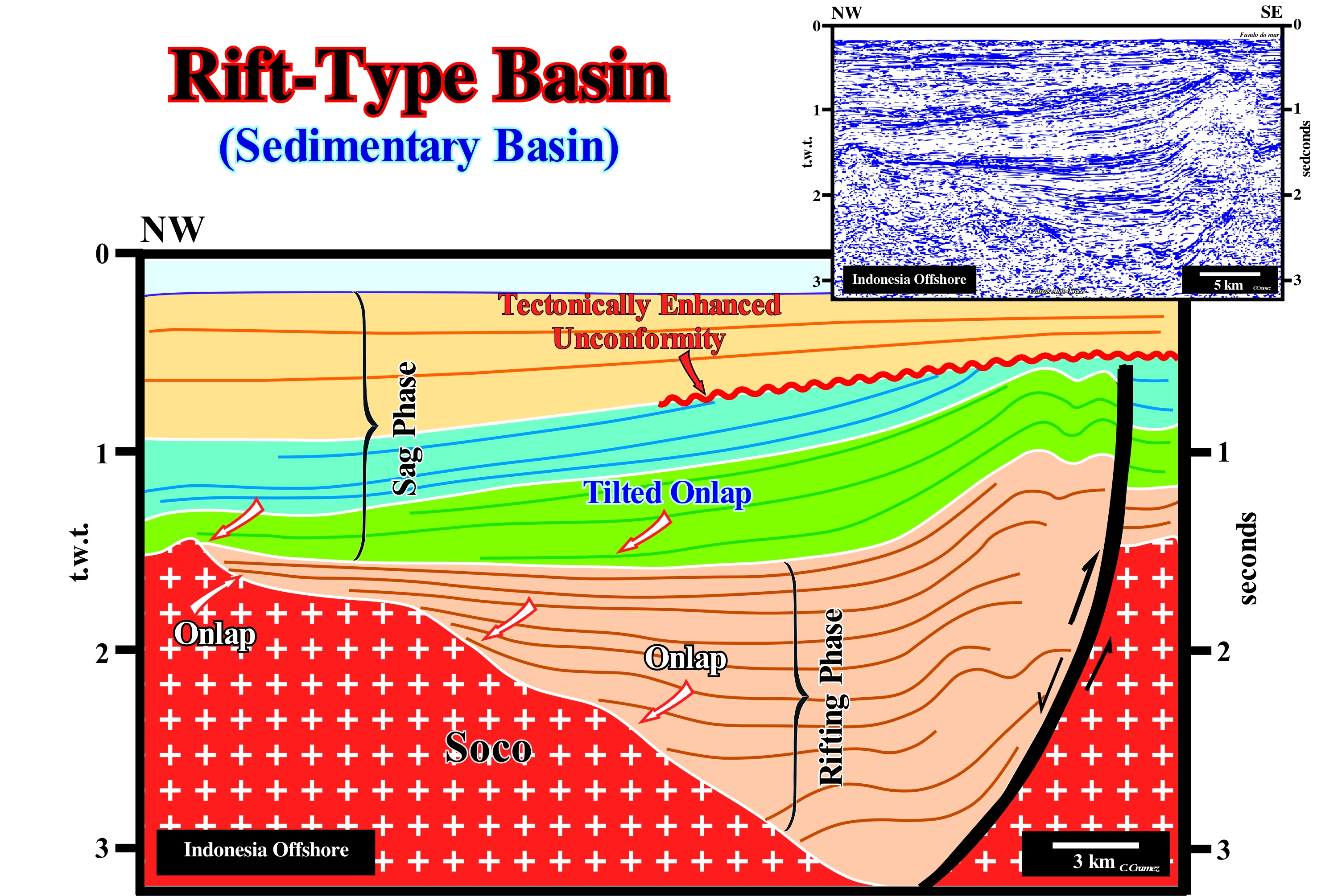
Although a rift-ype basin has the geometry of a halfgraben or graben, which corresponds, often, to the association of two halfgrabens with different vergences and ages, it can not be said that all halfgrabens or grabens are rift-type basins. The graben of the Euphrates, in Syria, for instance, is not a rift-type basin. It corresponds to the lengthening of a continental platform (shelf) and not to the lengthening of a supercontinent. A halfgraben or graben is a stretching geometry induced by a differential subsidence, whereas a rift-type basin is a halfgraben or graben associated with the breakup of a supercontinent. In other words, all rift-type basins are halfgrabens or grabens, but not all halfgrabens or grabens are rift-type basins. On this tentative geological interpretation of a Canvas auto-trace of an Indonesia offshore seismic line, a rift-type basin is, easily, recognized by its geometry in halfgraben and by the lengthening of the basement by the bordering normal border fault, behind the volcanic arch created by the subduction of the India descending lithospheric plate (oceanic crust). The rift-type basin (differential subsidence), which, in this example, corresponds to the rifting phase of a backarc basin, was fossilized by the sediments of the sag or cratonic phase (thermal subsidence). As this rift-ype basin developed in association with the formation of the Meso-Cenozoic megasuture, it forms part of an episutural basin (located within the megasuture). The sediments that fill it (usually lacustrine organic rich shales with interbedded sandy layers) and sediments from the lower part of the sag phase were shortened. This shortening was done by reactivation of the old normal fault bordering the halfgraben, which played in reverse fault. The end of the reactivation, that is to say, of the shortening is, perfectly, underlined by a discordance (erosional surface) that was, locally, tectonically enhanced (angular unconformity). The dating of the tectonic inversion, in relation to the migration of hydrocarbons, is a fundamental petroleum parameter in the oil exploration of these episutural basins composed of two sedimentary phases (rifting and sag or cratonic and phases).
Rift-Valley.........................................................................................................................................................................................................................Vallée du rift
Rifte (vale do rifte) / Valle del rift / Grabenbruch / 裂谷 / рифтовая долина / Fossa tettonica /
The term rift or rift valley was first used by J.W. Gregory (1984) to describe the morphology of the East African valleys: "Linear valley with parallel and near vertical sides between 30 and 100 km apart of the surrounding plateaus by large escarpments whose height can reach a few thousand meters and whose base probably fell along normal faults. " This term can not be used for the basins formed during the lengthening of the supercontinents prior to the breakup of the lithosphere, since in the vast majority of cases there is no associated significant negative topographic anomaly in the formation and filling of these basins (except when lengthening rate is much higher than the fill rate). These basins are called rift-type basins and not rifts. In fact, as the space available for sediments is created, by lengthening of the supercontinent lithosphere, it is immediately filled by sediments, which keeps the topography of the area more or less flat, which is very different of the rift valley, or the topography of the rift of the mid-ocean ridges. In contrast, the term rift and in particular, rift valley (Gregory, 1984) may well be used to denote the central valley of the mid-ocean ridges.
See: « Rift-Type Basin »
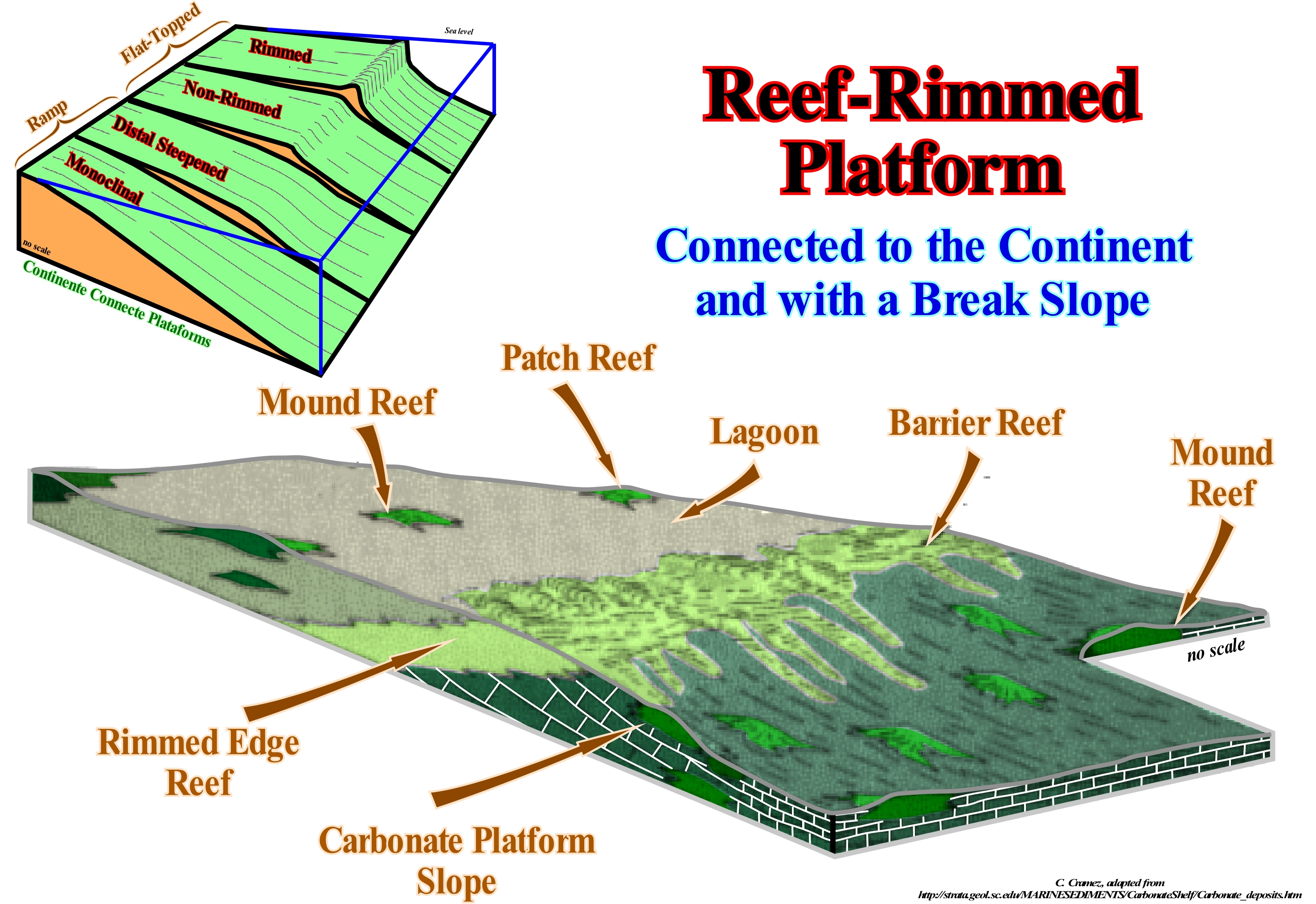
Rimmed Carbonate Platform...................................................................Plate-forme carbonatée auréolée
Plataforma Carbonatada aureolada (isolada) / Plataforma carbonatada aureolada (aislada) / Rimmed Karbonatplattform / 边礁碳酸台地 / Окруженная карбонатная платформа / Piattaforma carbonatica aureolata /
Platform with coastal break or rimmed edges formed by reefs or shoals*, mainly, carbonated sand.
See: « Deposition (carbonates) »
&
« Transgressive Interval »
&
« Reef »
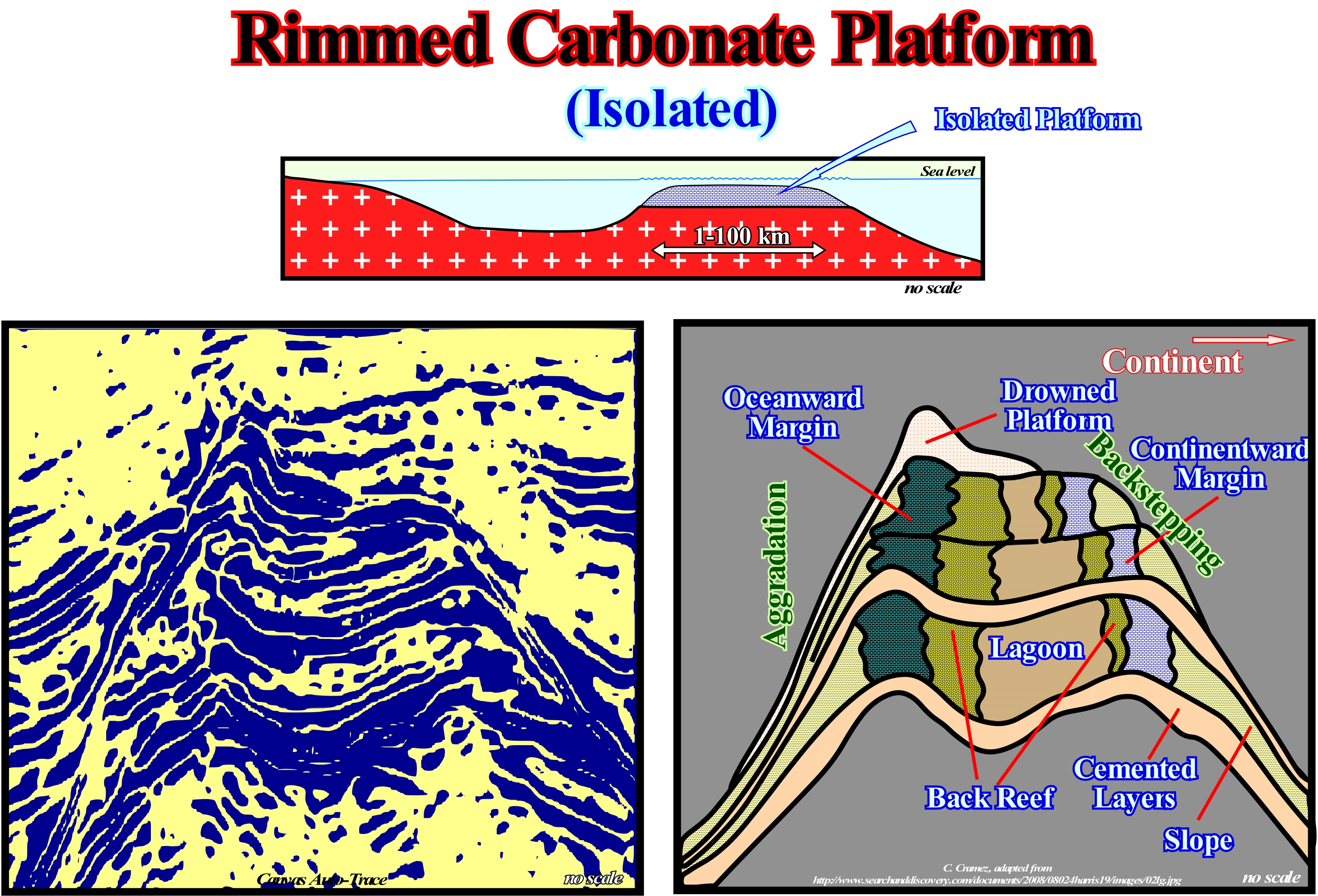
The geological sketch illustrated in this figure represents an isolated rimmed platform, i.e., a platform that is not connected to the mainland. In relation to a conventional rimmed platform, it not only has a different geometry, but also the facies (lithologies) and the oceanographic conditions vary around the edges. In a conventional rimmed platform, the facies line, created by the successive positions of the platform edges, which may or may not be the continental shelf, cuts the chronostratigraphic lines and it is formed by reefs or carbonated sands. In this sketch, the subgroups of the lowstand systems tracts group (LSTG), that is: (i) Submarine basin floor fans (SBFF) ; (ii) Submarine slope fans (SSF) and (iii) Lowstand prograding wedge (LPW) , are located in the lower parts and are fossilized by subgroups of highstand systems tracts group (HSTG), that is, by the Transgressive Interval (TI) and Highstand prograding wedge (HPW). When changes in the relative sea level, resulting of the combined action of tectonics and absolute (eustatic) sea level, i.e. of the supposed global and referenced to the Earth's centre, are weak or moderate, the productivity of carbonate is relatively small. The geometry of the platform is, mainly, retrogradational (backstepping) and relatively little important. This means that the transgressive interval (TI) is retrogradational and that, consequently, little sedimentary particles are deposited in the distal flat part of the platform. When relative sea level changes are moderate to strong, the carbonate productivity is important. Under these conditions, the rimmed platform has a aggradational and progradational geometry with important relief and transgressive interval sediments deposited, also, in the upper part of the platform slope. When carbonate productivity is important, it is difficult, on seismic lines and in the field, to separate the transgressive interval (TI) from the highstand prograding wedge (HPW). Due to the complexity of the parameters that control the formation of a rimmed platform, each platform has its own characteristics. Assuming a constant productivity, it can be said that retrogradational platforms are associated with significant subsidence rates, the aggradational platforms with intermediate rates, and progradational platforms with small subsidence rates. Most of the geoscientists consider five categories of carbonated platforms: A) Rimmed Platforms , which are characterized by the presence of reefs or calcareous sands of shallow (carbonated sandbanks covered by shallow sea water) on the edge of the platform and clay sands in the lagoon or on the open platform (this type of platform forms in calm waters and its extension varies between 10 and 100 km) ; B) Ramp Carbonate Platforms, in which the carbonated sands of the shoreline pass, at the base of the ramp, to clay sands and deep-water muds (in this type of platform, the reefs are rare and the width of the ramp can reach 100 km) ; C) Epeirial (or epíric) Platforms, which are characterized by the presence of tidal surfaces and protected lagoons (the width of an epeiric platform can reach 10,000 km) ; D) Isolated Platforms, in which the facies (lithologies) are quite controlled by the orientation of the prevailing winds: they have reefs and sandy bodies, as the rimmed platform, in the windward margin, but in the leeward margin, the sediments are more muddy (an isolated platform can reach 100 km wide) and E) Drowned or Dead Platforms, when they are under the photic zone (where there is not sufficient light for photosynthesis, i.e., to use of carbon dioxide and water to obtain glucose through the energy of sunlight). The platforms connected to the continent are divided into two large families: (1) Ramp Type and (2) Top-Flatened Type. In ramp type platforms two subtypes can be considered: (1.1) Monoclinal and (1.2) Distal Steepened. In top-flattened platforms there are also two subtypes: (2.1) Non-rimmed and (2.2) Rimmed. It is in the subtype (rimmed platform) that the designation of abrupt carbonated platform is more frequent. The absence of a barrier, such as that on the rimmed platform, is the result of a high energy that creates complex coastal lithologies with a high rate of sedimentary transport. Although barrier reefs are absent, reefs pinnacles and reef mounds can be found on non-rimmed platforms. Modern rimmed platforms are found mainly on the tropical coast of the Arabian Gulf, Shark's Bay (Western Australia) and Yucatan (eastern part). The most well known carbonate platform geometry is associated with tropical manufacturing processes, where carbonate platforms can be subdivided into three main sedimentary environments: A) Reef, which is the part of the carbonate platform created in situ by sessile organisms ; B) Internal lagoon (part of the platform behind the reef, which is characterized by shallow and calm waters with sediments composed of fragments of reefs and hard parts of organisms or terrigeneous sediments when the reef is epicontinental) and C) Slope, which connects the reef to the basin and acts as a sink for the excess carbonate sediment, although most of the sediment produced in the lagoon and the reef is transported by various processes and accumulated on the slope).
(*) Natural submerged ridge, bank, or bar that consists of, or is covered by, sand or other unconsolidated material, and rises from the bed of a body of water to near the surface (https://en.wikipedia.org/wiki/Shoal).
Rimmed Reef Platform..............................................................................................................Plate-forme récifal auréolée
Plataforma recifal aureolada / Plataforma de arrecifes aureolada / Reef-umrandeten Plattform / 边礁环绕的台地 / Обрамленная рифом платформа / Piattaforma scogliera aureolata /
Carbonated platform with the edge underlined by reefs. In general, carbonate platforms have an edge under a wate-depth of several tens of meters and naturally do not have reefs,. They area sometimes fringed, i.e., they have a more or less continuous barrier formed by reefs that along the edge of the platform, under a very small water-depth, which may emerge during low tide.
See: « Rimmed Carbonate Platform »
&
« Reef »
&
« Drowned Carbonate Platform »
When a geoscientist talks about platform, in general, he/she is referring to the continental shelf, which is the slightly sloping surface of the sea floor, limited between a water-depth from 0 to 200 m, which is not the case for a carbonate platform. Theoretically, under normal geological conditions, the water-depth of a limestone platform can not exceed the depth of the photic zone. Without the energy of sunlight there can be no in situ formation of carbonate. To avoid misunderstandings, it is important to know if the term platform is being applied to a sedimentary context where the clastics are predominant or to a carbonated context. Most of the geoscientists consider five categories of carbonated platforms: A) Rimmed Platforms, which are characterized by the presence of reefs or calcareous sands of shallow (carbonated sandbanks covered by shallow sea water) on the edge of the platform and clay sands in the lagoon or on the open platform (this type of platform forms in calm waters and its extension varies between 10 and 100 km) ; B) Ramp Carbonate Platforms, in which the carbonated sands of the shoreline pass, at the base of the ramp, to clay sands and deep-water muds (in this type of platform, the reefs are rare and the width of the ramp can reach 100 km) ; C) Epeirial (or epíric) Platforms, which are characterized by the presence of tidal surfaces and protected lagoons (the width of an epeiric platform can reach 10,000 km) ; D) Isolated Platforms, in which the facies (lithologies) are quite controlled by the orientation of the prevailing winds ; they have reefs and sandy bodies, as the rimmed platform, in the windward margin, but in the leeward margin, the sediments are more muddy (an isolated platform can reach 100 km wide) and E) Drowned or Dead Platforms, when they are under the photic zone (where there is not sufficient light for photosynthesis, i.e., to use of carbon dioxide and water to obtain glucose through the energy of sunlight). A rimmed reef platform has characteristics of agitated sea, near the edge and of calm sea, in the lagoon. Where the energy is great, they form reef, but not exclusively. Organic productivity is, particularly, important near upwelling sea currents. The lagoon is, generally, a low energy environment and its extent depends on how the reefs of the surround dissipate wave energy. If in the lagoon, the energy of the waves is insignificant, the environment is of poor circulation and formation of evaporites in saline can not be excluded. In this sketch, it is, easy, to verify that a sequence-paracycle of a rimmed reef platform is the lateral association of (1) Lagoon shales ; (2) Shallow sands ; (3) Barrier reefs and (4) Carbonate platform slope deposits, i.e., synchronous and genetically associated deposition systems. A vertical association of these sequence-paracycles, of course, without relative sea level falls between them, forms a rimmed reef platform. The most well known carbonate platform geometry is associated with tropical manufacturing processes, where carbonate platforms can be subdivided into three main sedimentary environments: A) Reef, which is the part of the carbonate platform created in situ by sessile organisms ; B) Internal lagoon (part of the platform behind the reef, which is characterized by shallow and calm waters with sediments composed of fragments of reefs and hard parts of organisms or terrigeneous sediments when the reef is epicontinental) and C) Slope, which connects the reef to the basin and acts as a sink for the excess carbonate sediment, although most of the sediment produced in the lagoon and the reef is transported by various processes and accumulated on the slope. The example shown here corresponds to an isolated platform. The platforms connected to the continent are divided into two large families: (1) Ramp Type and (2) Top-Flatened Type. In ramp type platforms two subtypes can be considered: (1.1) Monoclinal and (1.2) Distal Steepened. In top-flattened platforms there are also two subtypes: (2.1) Non-rimmed and (2.2) Rimmed. It is in the subtype (rimmed platform) that the designation of abrupt carbonated platform is more frequent.
Ringing (Reverberation)................................................................................................................................................................................Ringing (Sismique)
Ringing (sísmica) / Ringing / Ringing (seismische) / 振铃(地震) / Реверберация (сейсмическая) / Ringing (sismica) /
When the seismic rays of a marine emitter are reflected several times between the bottom and sea level, which can produce several multiples of the seabed. Synonym with Reverberation or Pedaling.
See: « Diffraction (seismic wave) »
&
« Reverberation »
&
« Reflection Seismic »
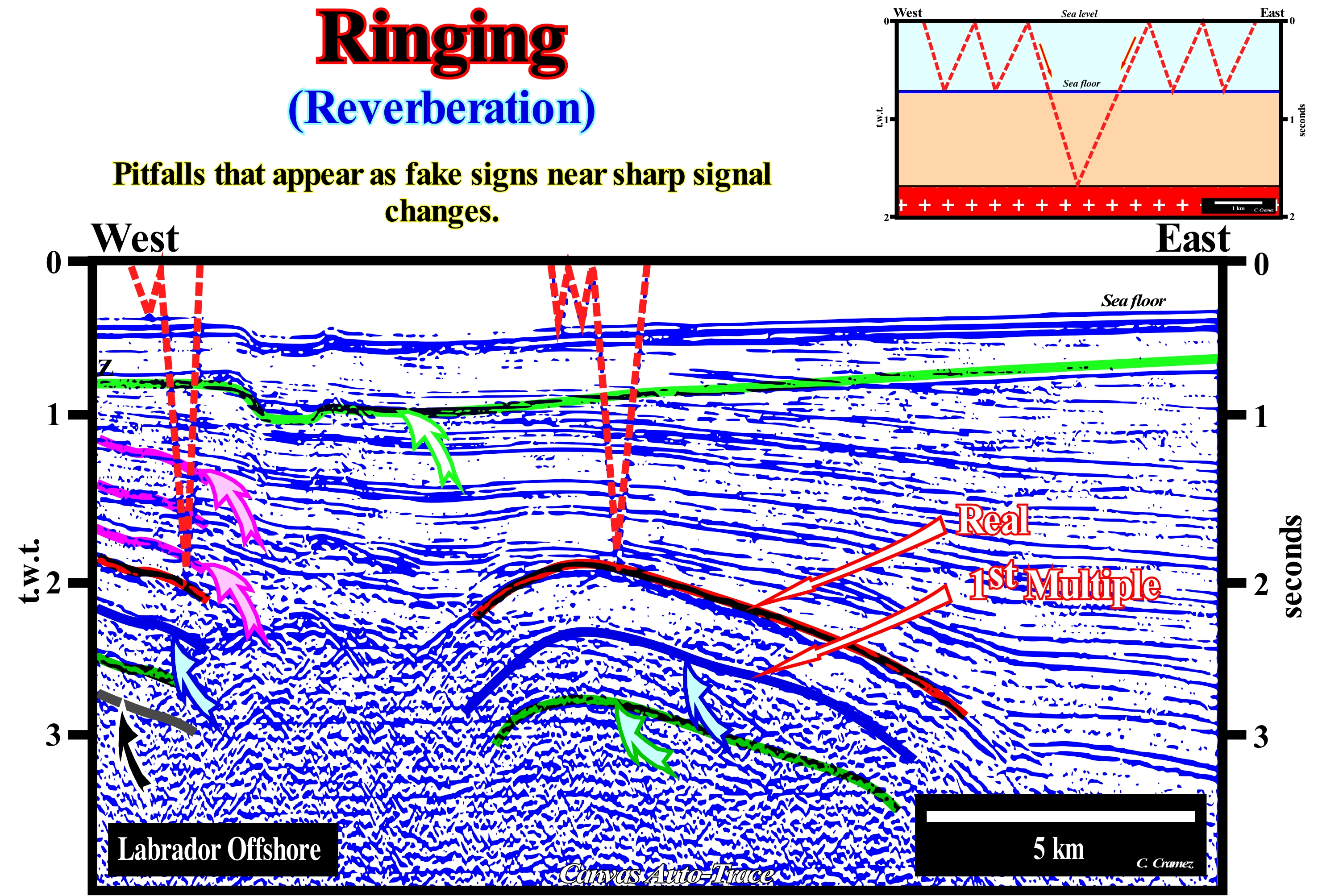
On this Canvas auto-trace of a Labrador (Canada) offshore seismic line several multiples induced by the water-depth can be recognized. A strong reflection is visible, approximately, at the depth of 2 seconds (double time, i.e., t.w.t.), mainly, in the central part of the line. This reflection emphasizes a sedimentary interface characterized by a strong contrast of acoustic impedance (interface between the supracrustal rocks, which forms the basement in this region and the sediments of the continental margin divergent). When the energy reflected by this interface reaches sea level, it is reflected toward the sea floor, which reflects it back to the surface. This ringing, between the top and bottom of the water column, can be done several times. The time spent on ringing is added to the time the energy spent to reach the deep interface and return to the hydrophone, which produces multiples, at least of 1st and 2nd multiples of the reflector associated with the deep interface. The difference in time between the primary reflection and its first multiple is equal to the time that the seismic waves spend across the water-depth. In the same way, the difference (in double time) between 1st and 2nd multiple, or between the second and third, is always equal to the thickness of the water-depth in time (t.w.t.). This forces the interpreter to be cautious when under a strong reflective event one finds, more or less, the same geometry (sometimes more inclined if the water-depth increases strongly in a particular direction). Every time this happens the interpreter has to test the geological significance of the lower event. Seafloor multiples, easily, visible on this seismic line are by far the most typical multiples by ringing. On this line are visible at least the first three (note the in-depth repetition of the small negative anomaly of the sea floor). The continentward (west) dip of the sea floor rather eastward, as is, generally, the case, is due to the erosive action of the icebergs along its southern course towards Newfoundland.
Ringing (Seismic)..............................................................................................................................................................................................Pédalage (Sismique)
Pedalagem / Ringing (sísmica) / Ringing (seismische) / 振铃(地震) / Педалирование (сейсмика) / Pedalata (sismica) /
Synonymous with Ringing and Reverberation, i.e., when the seismic rays of a marine emitter are reflected several times between the bottom and sea level, which, of course, produces multiples of the seabed.
See: « Diffraction (seismic wave) »
&
« Reverberation »
&
« Reflection Seismic »
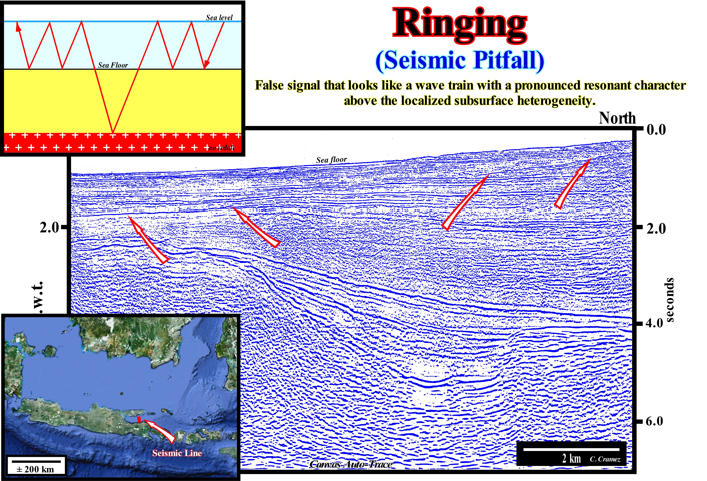
The propagation of a seismic disturbance through a heterogeneous medium is extremely complex. One of the most important assumptions to make is that seismic waves have an elastic displacement in the medium, but this condition is not true near the source, where the deformations are not elastic (the particles of the medium are definitely displaced from the initial positions). From a distance from the source it is reasonable to assume that the amplitude of the disturbance falls within the boundary where the deformation of the medium is elastic, thus allowing passage (propagation) of the seismic waves. The medium particles describe a simple harmonic motion, and the seismic energy is transmitted as a complex set of waves. As illustrated above, when energy is released from a point P, located near the surface of a homogeneous medium (in this example the sea level), some of the energy propagates within the medium (in this case water) as a body of waves. The S waves do not propagate in the fluids (gases and liquids), since they do not support shear forces. The remnant portion of seismic energy propagates in the form of surface waves such as ripples on the surface of water when a rock is thrown (Love and Rayleigh waves). When the seismic waves (P waves) arrive at the rocky water-bottom interface, a large energy start up is reflected to the water-to-air interface, that is, sea-atmosphere level, which in turn reflects the other energy to the seabed and so on, until the energy dissipates. In a large majority of seismic lines, as in the auto-trace illustrated in this figure (West offshore of the island of Java, Indonesia), in which the water-depth, progressively, increases southward (as opposed to the dip of chronostratigraphic seismic reflectors), it is, easy, to recognize a ringing induced reflector from the sea floor since it cuts off the chronostratigraphic reflectors and that its time depth is double that of that of the sea floor.
Rip Current..........................................................................................................................................................................................Courant sagittal
Corrente dos agueiros, corrente de concentração / Corriente de desgarre (de las rompientes) / Ripströmen / 離岸流 / Стреловидное течение / Corrente di ritorno, Corrente di risacca, Corrente di risucchio /
Synonymous with compensating current, i.e., a transverse or oblique current to the shoreline, which is directed towards the open sea and that affects the mass of superficial and deep-water. Beyond the surf zone, it opens into fans, dividing into branches that return to the shore (in the surfing area) with the uprush current.
See: « Stream »
&
" Surge Current "
&
" Concentration Current "
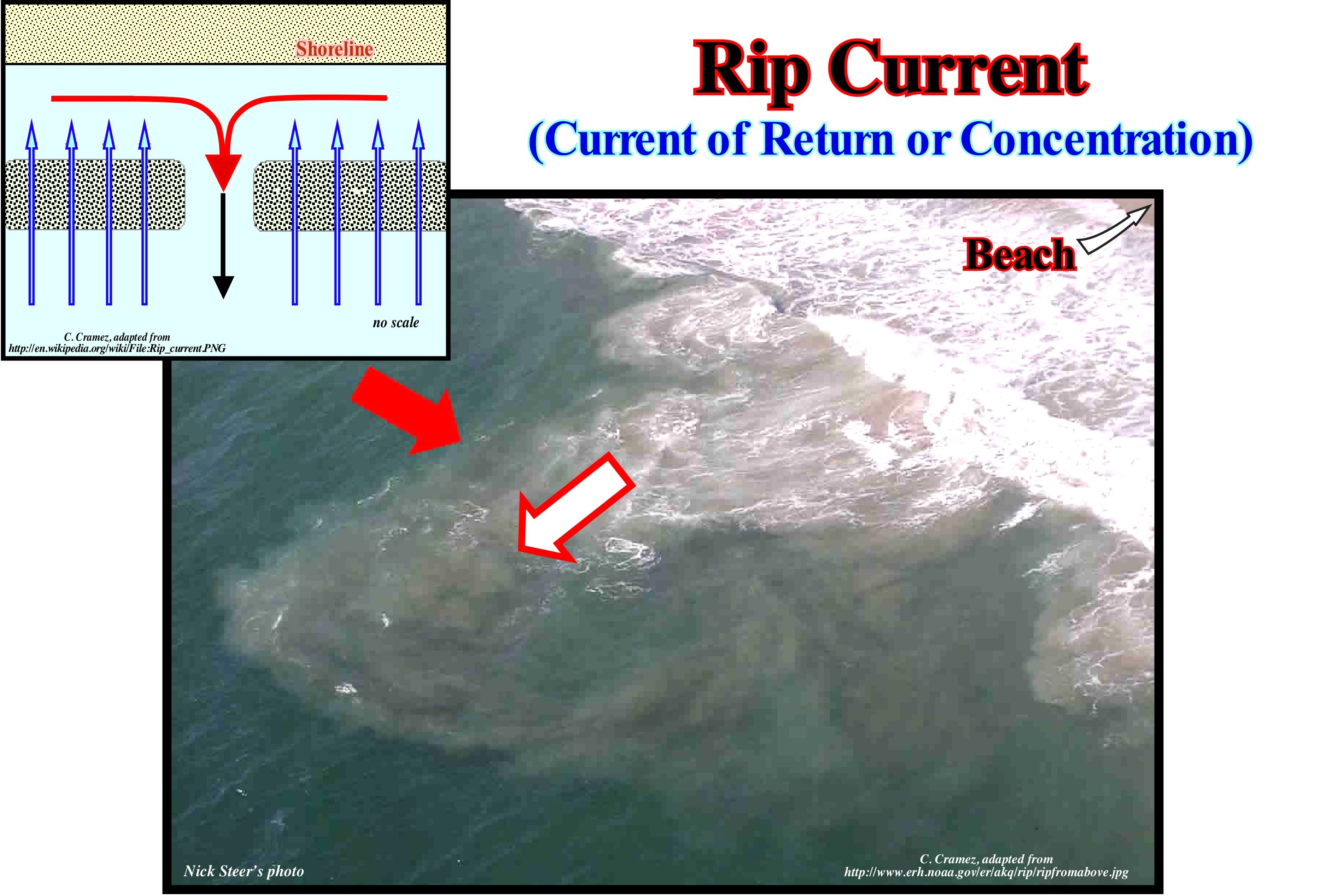
In this photo, as you can, easily, deduce, the shoreline is located rightward (you see a little sand beach in the upper right corner). The current that is moving seaward (indicated by the arrow) is a rip current (return or concentration current of certain geoscientists). The characteristics of this type of current are: (i) A channel of agitated water with a great deal of ripple, whose width rarely exceeds one or two tens of meters ; (ii) An area in which sea water has a different colour ; (iii) A line of foam, algae or plant remains moving, rapidly, seaward ; and (iv) A break in the wave approaching the shore is, readily, recognizable. The formation and location of an rip current can be explained as follows: (a) When the wind and the waves push the sea water continentward, water is often forced, laterally, by the waves approach ; (b) This water flows along the coast until finding an outlet to the sea. The resulting stream is the rip current whose path can be visualized by placing a dye at the beginning of the current near the shoreline. As stated above, the rip current is, usually, narrow and located, often, between sandbanks, under the piers, or along the walls. Many people think that the rip current is strong enough to drag people under the surface of the water, which is not true. This type of current is just strong on the surface and that is why it can diminish the sea waves, which leads to the illusion of a particularly quiet area, which unfortunately attracts many bad swimmers. In case you are caught by this type of current, do not try to fight against it. Let it take you away from the shoreline (rarely more than 100 meters) until you get out of it or swim sideways (its width rarely exceeds one or two tens of meters). When you are outside, swim calmly to the beach.
Rising Tide (Flood, flow)..................................................................................................................................Marée montante, Flux, Flôt
Enchente, Maré cheia / Flujo, Marea creciente / Flut, Steigen / 涨潮 / Приливная волна / Marea montante /
The part of the tidal cycle during which the sea level rises. Synonym of HighTide or Full Tide.
See: « Ebb, Faling Tide »
&
« Intertidal Beach »
&
« Shoreface »
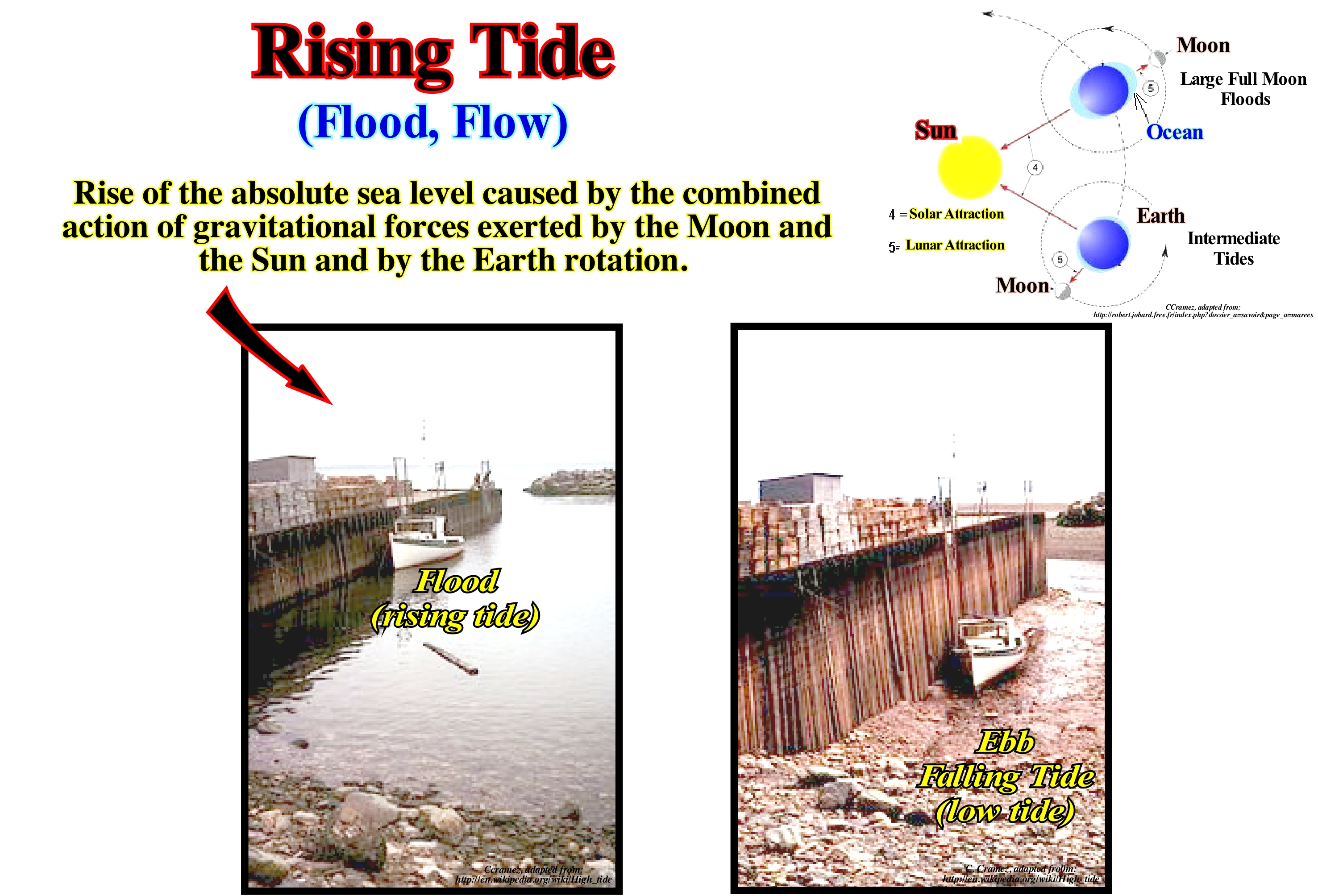
In this figure, at maximum of the rising tide current (flood, flow), or in other words, in the high-tide, the sea level is more or less three meters from the top of the quay. The boat no longer rests at the bottom of the exhumed sea, since almost the whole area was covered by the sea (compare with the figure, which represents the same area during the low tide). The tide is a wave of oscillation (wave composed of particles of water, each of which oscillates around a point with little, if any, permanent change of position, meaning that the particles of water move in a manner orbital) of low amplitude and with a large wavelength, which forms in the high sea, due to the luni-solar attraction on the surface of the waters. There are two tidal currents: (i) Flood, or rising tide current, which runs from the shore to the coast, where it causes an accumulation of water whose maximum is called high-tide or full tide and (ii) Ebb or falling tide current that moves toward open sea, draining the water accumulated next to the coast during the flood. The lowest water level reached by the falling tide is low-tide or empty tide. One can say tides are falls and rises of the sea level, with a period of about 12 and a half hours, caused by the combination of the effects of the Earth's rotation and the gravitational pull of the Moon and the Sun. When the Sun and Moon are in conjunction or opposition the tides are spring (with great amplitude). When the Moon is in waning or crescent (quadratures), the tides are neap, i.e., with minimum amplitudes. The circulation of the tidal currents induces formation of, more or less, symmetrical submarine deltas, which, generally, form in the openings (inlets) of the lagoons or in the straits. The delta that forms on the inner side is the flood delta and that formed on the outer side is the ebb delta. The presence of tidal deltas, as well as the shape and dimensions depend on three main factors: (i) Sedimentation ; (ii) Wave interaction and tidal processes and (iii) Tidal flow during the tide cycle. Tidal deltas are excellent replacement reservoirs of sand material used to restore the size of beaches subject to erosion of coastal currents.
Rising Toplap...............................................................................................................................................Biseaux supérieurs ascendants
Biseaux supérieurs ascendants / Biseles superiores ascendentes / Steigende toplaps, Aufsteigende höher Fasen / 瑞星toplaps, 升序更高的斜面 / Поднимающиеся регрессивные прилегания / Rising toplaps /
Toplap dipping upstream (opposite direction of turbiditic currents) associated, in general, with submarine slope fans and, in particular, overbank deposits ("gull wings"). This type of geometical relationship is also frequent in association with the centers of volcanic expansion. Synonym with Ascending Toplap and Crescent Toplap.
See: « Toplap »
&
« Drape »
&
« Geometrical Relationship (reflector, stratum) »
A rising toplap never exists in isolation. This type of reflection termination is always associated with another with an opposite vergence (polarity). In general, within a sequence-cycle, rising toplaps characterize overbank deposits, in particular turbidite natural marginal dikes (levees), which, preferably, form in association with the deposition of the submarine slope fans (SSF) of the lowstand systems tracts group (LSTG). These lapouts are created by the overflow of the turbiditic currents on both sides of the depression or channel (when there is erosion) along which the turbidite currents flow. Due to the particular mode of deposition of natural turbiditic marginal dikes, the rising toplaps are not only steeply sloped upwards, but they have an opposite vergence (P. Vail's "gull wings" structures). Since the first turbidite current begins to decelerate, i.e., as long as it reaches the abyssal plain, two small lateral lobes are formed on each side of the central area of the current flow, where the velocity of the current is stronger. This area is a transport area, i.e., of nondepositional area. It corresponds to the area where the current is stronger and therefore carries the material further away. The following currents take advantage of the depression between the initial lateral lobes (which are not usually eroded) as a passage zone, i.e., the successive turbiditic currents are, sooner or later, channelized by the natural marginal dikes. When the height of the currents exceeds the height of the depression, they overflow and deposit the transported sedimentary particles (natural marginal dikes) forming higher slopes more inclined than the lapouts associated with the previous lobes. As the currents overflow on both sides of the central depression (or "turbidite channel"), these lapouts (reflection terminations) have opposite polarities. This type of lapout lies not only in the submarine slope fans (SSF), but also in volcanic deposits as illustrated on this tentative geologically interpretation of a Canvas auto-trace of a Pakistan offshore seismic line. This offshore corresponds to the stacking of several types of sedimentary basins from Bally and Snelson (1980). In the area where the seismic line of this tentative interpretation was shot, just the divergent margin (mainly the submarine slope fans with huge "gull-wing" structures), is visible above the subaerial volcanism (SDRs). This volcanism is considered posterior to the breakup of the lithosphere of the small supercontinent Gondwana. It corresponds to the initial lateral accretion of individualized lithospheric plates when the expansion centres, i.e., volcanic dykes and volcanoes, reach the Earth's surface in subaerial environments. This is why the volcanic material flows laterally towards the individualized continents by the breakup of the lithosphere. This subaerial volcanism forms the lower part of the divergent margin. Since the expansion centres become submerged, due to the weight of successive lava flows, the volcanic material that reaches the sea floor solidifies, rapidly, in the form of pillow lavas that constitute the upper part of the sheeted dykes. One of the volcanoes associated with this volcanic subaerial crust is, perfectly, visible on this tentative interpretation, as well as the lavas spills and the associated rising toplaps. The term caldera used on the tentative interpretation does not correspond to a conventional caldera, whether it is the result of emptying of a magma chamber or whether it is the result of an intense hydrothermal alteration. This type of caldera is formed in association with subaerial volcanic spreading and, particularly, in association with the formation of Seaward Dipping Reflectors: (i) The vast majority of subaerial basaltic flows postdate to the break-up of the lithosphere ; (ii) They are vomited by volcanoes and central fissures aligned parallel to the line of breaking ; (iii) They taper continentward and can reach more than 10 km in thickness ; (iv) In longitudinal seismic profiles (parallel to the breaking line), the SDRs are convex upward, with dips and thicknesses increasing basinward ; (v) The seaward dipping results from the stacking of the most recent flows, which, progressively, move basinward ; (vi) In the transverse profiles, SDRs are sub-horizontal ; (vii) SDRs form a band with low magnetism, located upstream of the oldest magnetic anomaly of the oceanic crust.
Rising Toplap (Climbing toplap).......................................................................................Bisel supérieur croissant (ascendant)
Bisel superior crescente / Bisel superior ascendente / Steigende toplap, Bevel oberen Rahmen / 瑞星顶超 / Поднимающееся регрессивное прилегание / Bisello superiore ammontare /
Toplap upwardly sloping (opposite direction of turbiditic currents flowing), which is, generally, associated with turbiditic submarine slope fans and, in particular, overbank deposits (turbiditic levees type "gull wings"). Synonym with Ascending Toplap and Climbing Toplap.
See: « Toplap »
&
" Gull Wings (turbidites) "
&
“ Rising Toplap"
A rising toplap never exists in isolation. This type of lapout is always associated with another with vergence or polarity opposite (inclination). In turbidite systems, these lapouts are created by overflowing turbidity currents (gravitational sedimentary flows of water and sediment mixtures moving due to gravity without significant influence of the medium above them) to either side of the depressions ( turbidite channels, when there is erosion), along which they flow towards the abyssal plain. Within a sequence-cyle, induced by a 3rd order eustatic cycle, whose duration is between 0.5 My and 3-5 My*, the rising toplaps are found in the submarine slope fans (SSF) although they may also be found in the subaerial volcanic deposits in association with the lava flows, which are implemented immediately after the break-up the lithosphere of a supercontinent, that is, at the base of the divergent Atlantic-type margins. Rising or climbing toplaps, as certain geoscientists say, characterize overbank deposits and, in particular, natural marginal dikes (levees), whether turbid or fluvial. In the particular deposition of the turbidite natural marginal dikes, the rising toplaps, which are deposited on opposite slopes, are increasingly inclined upwards. With the fills of the mid-depression, they form the structures that P. Vail called "seagull wings." The deposition of natural turbiditic marginal dikes can be summarized as follows: (i) Since the first turbidytic stream begins to decelerate, it loses transport competence, and the sedimentary particles that it carries deposit in two small lateral lobes on each side of the central zone of passage of the stream, which corresponds to an area of no deposition ; (ii) The zone without deposition underlines the area where the turbidite current is more energetic and which carries the material further downstream ; (iii) The following currents take advantage of the morphological depression between the initial lateral lobes as a passage zone, and thus, the following turbidite currents are channelized through the natural dikes (levees) ; (iv) When the height of the currents exceeds the height of the depression between the marginal dikes, they overflow and deposit the sediments above the previous dikes with a significant lateral accretion, creating increasing sloping rising toplaps ; (v) As the currents overflow on either side of the central depression (or "turbidite channel", when there is erosion), the coeval rising toplaps have opposing polarities and form gull-wing structures ; (vi) After this phase of advancement, characterized by high density turbidite currents with velocities greater than 15 m/s, there is a retreat phase (aggradation and sliding) during which the density and velocity of the turbidite currents are weaker and the depressions, between the natural marginal dykes, are filled, in retrogradation, by sandy/shaly sediments, that in certain conditions, can be considered as reservoir-rocks. Rising toplaps are easily recognized in certain seismic lines of the North Sea. On the Canvas auto-trace, illustrated in this figure, the rising toplaps are not evident to a naive geoscientist, i.e., to a geoscientist who still continues to think that Observation precedes, always the Theory and that has to have the empty head of geological knowledge ("tabula rasa") to not contaminate its interpretation with preconceived ideas. For a modern geoscientist, the presence of rising toplaps on this auto-trace is obvious as suggested in the tentative interpretation even if the original seismic line is not of good quality. Not only does he knows what he must find on the auto-trace, but where he must find it. In other words, when a geoscientist looks at a seismic line there are no captions that tell him what he is seeing. He has to know or have an expectation of what he wants to see, which seems and is a bit circular, but that may explain, in part, why scientific progress is difficult.
(*) A sequence-cycle is constituted by a stacking of sedimentary systems tracts, which consist of one or several sequence-paracycles. The sequence-paracycles are successions, relatively, conform of a bed or a set of beds, genetically, related and bounded by marine flooding surfaces or correlative depth-water paraconformities. In the initial model proposed by EPR (Exxon's "Exploration Production Research"), the paracycles-sequence were called parasequences. They represented the sedimentary deposits settle down during an eustatic paracycle, i.e., that the parasequences were part of a hierarchy of super-cycles, cycles, and paracycles that reflected relative sea level changes of different orders of magnitude. The duration of the eustatic paracycle was estimated to be about 2 million years and has been described as a 4th-order relative sea level cycle, which is not true, since it shows no cyclicity. There is no no relative sea level falls between eustatic paracycles.
River.....................................................................................................................................................................................................................................................................Fleuve
Rio / Río / Fluss / 河流 / Антодит (образование, имеющее вид цветка) / Fiume /
Natural water-course, generally, sweet, flowing towards the sea, lake or stream. In some cases, a river flows into the underground or dries completely before encountering another water-body. The term river is, generally, used for large streams, while creek, brook, arroyo, rill, runnel etc., are used for smaller streams.
See: « Bayline »
&
« Meander »
&
« Provisional Equilibrium Profile (river) »
Rivers and, in general, all water-courses are the main erosive agents that transport the sedimentary particles to the depositional centres. The term erosion can have two meanings, one wide and one narrower. The narrow sense identifies erosion and excavation. The broad sense means digging plus the result of digging, i.e., digging and transporting the plucked materials plus the accumulation of those materials. The space, which is occupied by the water of the river is the bed. A river may have several beds: (i) A larger bed or bed of flood, i.e., any area that the river may flood and which it covers with alluvium ; (ii) Ordinary or apparent bed that corresponds to the limited area between the banks, which is occupied by material rolled by water, poorly covered with vegetation and without dwellings, which is not the case with the larger bed and (iii) Channel* that is the small zone of the apparent bed where the river flows when the water level is low. In an apparent rectilinear bed the channel is always sinuous, as illustrated in this photograph of the Lima river (Portugal). If the channel is not very irregular, due to rocky outcrops, its flat outline and its transverse profile are connected by the relationship between the depths and the sinuosities. There is in each sinuosity or curve of the river a deeper sector than those found in the parts situated immediately downstream or upstream: these are the lows or pools of the river. Between the lows, the shallower parts, which are more rectilinear and oblique in relation to the apparent bed are the river's shoals The profile through the lows is asymmetrical and the maximum depth lies with the concave margin. The profile through the shoals is symmetrical (more or less a trapeze). At the exit of each low, the bottom of the river dips upstream. The slope of the surface of the water is strong on a shoal and the speed greater. However, when water rises, the dips of the lows and shoals tend to equalize. In a stream the following parts can be distinguished: : (i) The Spring ; (ii) The Source ; (iii) The Headwaters ; (iv) The Confluence ; (v) The Run ; (vi) The Bar ; (vii) The Riffle ; (viii) The Channel ; (ix) Rapids ; (x) The Floodplain ; (xi) The Thalweg ; (xii) The Wetted Perimeter ; (xiii) The Knickpoint ; (xiv) The Waterfall or Cascade ; (xv) The Mouth ; (xvi) Drainage basin ; (xvii) The Gaging Station. The Spring* is the point at which the stream begins or emerges from an underground path through poorly consolidated sediments or caves (the latter case being particularly frequent in calcareous regions where karsification is abundant and where a current may have an underground course, more or less, long before it emerges. The spring is the point where groundwater flows out of the ground, and where the surface of the aquifer meets the ground surface. The Source is the spring from which the current originates or any other point that originated it. The source is simply the point at which it starts, i.e. the original point from which the river or stream flows. A river's source is sometimes a spring. The Headwaters is the part of the current near the source (term used, especially when the current has several sources). The Confluence is the point where two currents come together (when two distributives have approximately the same importance, the confluence may be called a fork. The Run is the rectilinear segment where the stream flows without agitation (swimming-friendly area), the current it is deeper and flows more slowly. The Bar is a shoal that develops in a stream as sediment is deposited as the current slows or is impeded by wave action at the confluence. The Riffle is the segment or area where the flow is shallower and more turbulent. The Riffle is segment or area where the water depth is lower and more turbulent. The Channel is the depression created by the erosion that allows the flow of the current. The Floodplain is the region adjacent to the stream which is subject to being flooded when the stream overflows. The Thalweg is the longitudinal section of the river or the line connecting the lowest point of the channel from the source to the mouth. The Wetted Perimeter is the line on which current surface meets the channel walls or the perimeter of the cross sectional area that is "wet". The Knickpoint is the point on a stream's profile where a sudden change in stream gradient occurs. The Waterfall or Cascade is the fall of water where the stream goes over a a knickpoint. The Mouth is the point at which the current is discharged and which, generally, corresponds to the shoreline, possibly via an estuary or delta. The Drainage basin is the area of land where water flows into a stream. The Gaging Station is the demarcation point along the current path which is used as the reference mark and where the control apparatus are installed. A river basin or drainage basin for a water-course refers to the whole of the territory and of tributary rivers that drain the waters for this structural water-course, which usually flows into an ocean
(*) Type of landform consisting of the outline of a path of relatively shallow and narrow body of fluid, most commonly the confine of a river or strait (https://en.wikipedia.org/ wiki/Channel_(geography).
River-Delta System.........................................................................................................................................................Système fleuve-delta
Sistema rio-delta / Sistema río-delta / Fluss-Delta-System / 河流三角洲 / Система река-дельта / Sistema fluviale-delta /
Sedimentary deposits, associated with a river and to the delta created by it, generally, dominated by floods. In a delta river system, the configuration of the sedimentary stacking and evolution are apparently controlled by: (i) Initial uplift of the drainage basin ; (ii) Denudation velocity ; (iii) Gradient of each of the systems and (iv) Volume and concentration in sediments of each flooding, which are a function of the amount of water and sediments available in the system (Mutti, 1996).
See: « Davisian Cycle »
&
« Littoral System »
&
« Alluvial Delta »
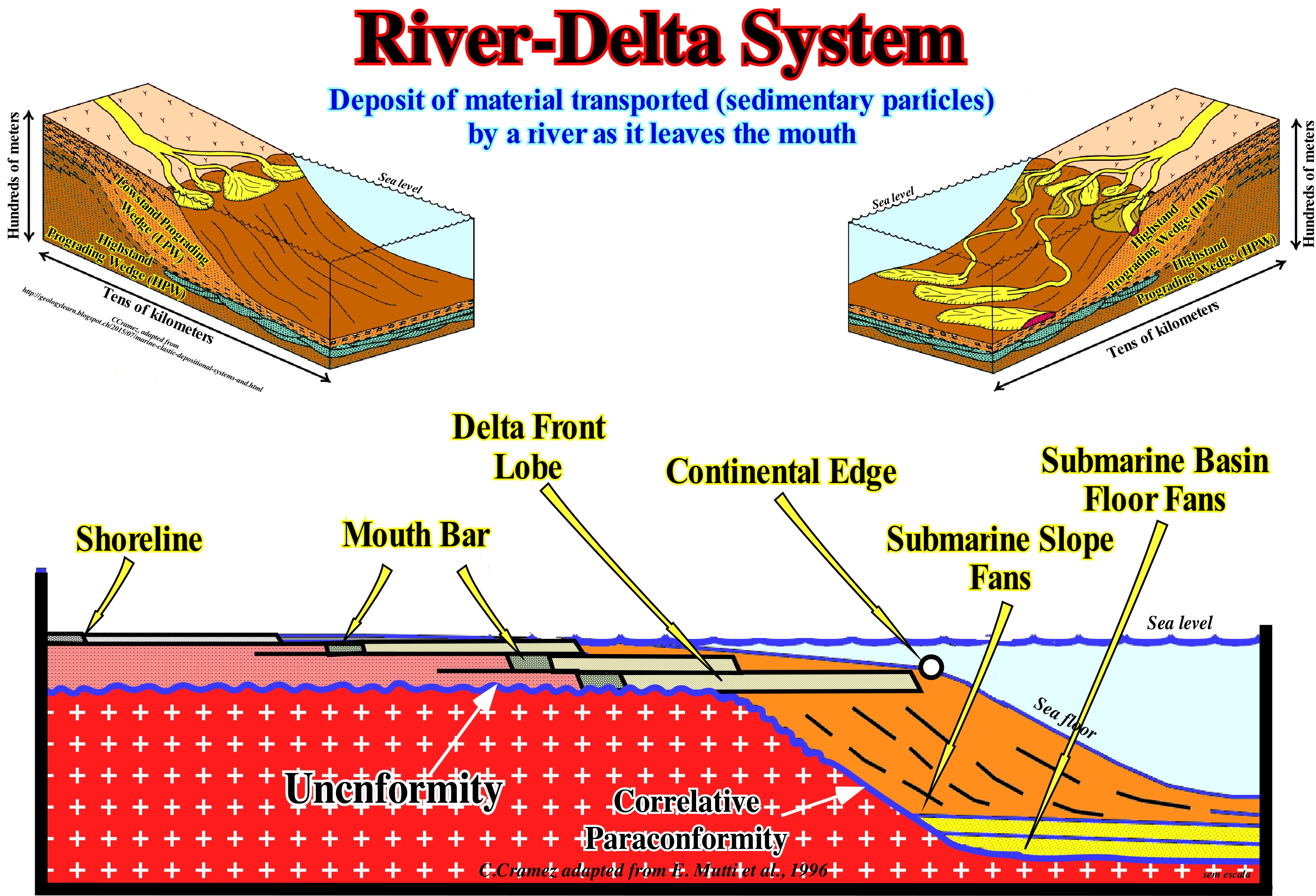
A delta (not to be confused with delta building) can have a wide variety of shapes and characteristics depending on the balance between energy, the load of the river system and the dynamics of the sea. There are several delta classifications. The most widely used is based on the shape of the delta, which reflects the factors that control the energy of the system. Two major classes can be considered: (i) Constructive Deltas and (ii) Destructive Deltas. Constructive deltas form when fluvial sedimentary processes and processes dominate the system. They occur in two forms: (a) Bird Foot Deltas, such as those of Mississippi Delta Building and (c) Lobate Deltas, such as those the Yukon Delta Building. In both cases, the sedimentary charge is very important, relatively, to the marine processes, which tend to disperse tie sedimentary particles along the coastline. Bird Foot or finger deltas have a higher mud content than the lobated deltas and tend to bury more quickly when they become inactive. Destructive deltas form when the energy of the coastline is strong. The sedimentary particles* supplied by rivers are removed by sea waves or coastal currents. Certain deltas such as those of the Rhone Delta Building or the Nile Delta Building are dominated by the action of the waves. The sedimentary particles are deposited in arc-shaped coastal barrier-bars. The deltas dominated by the tides almost always have a radial geometry. The alluvial deltas ("fan-delta") and the braided deltas are composed of coarse material. The former are formed when an alluvial fan is, directly, deposited in a body of water (Gilbert-type deltas), and the latter are associated with a braided fluvial system (braided rivers are characterized by the presence of conglomerate and sandstone deposits, in which a certain stratification is already predicted.) In alluvial and river deltas, tectonic activity and catastrophic floods are predominant. They are characterized by small and and medium river systems with high drainage basins and transfer zones located near the basin edge (which is almost always the continental edge). In the geological model of Emiliano Mutti, illustrated in this figure, the shoreline and the continental edge are well visible. The continental edge is also the basin edge (the continental edge is not the basin edge only in basins without continental platform (no shelf), i.e., under lowstand geological conditions and during the 2nd stage of development of the highstand prograding wedge (HPW) of a sequence-cycle). The basin, at that moment, has a continental shelf, whose water-depth is, relatively, shallow. The global retrogradation of the mouth-bars and delta front lobes are, easily, recognized, which implies increasingly important marine ingressions and a deficiency of terrigeneous influx following the deposition of a lowstand prograding wedge which has fossilized turbidite deposits (submarine basin and slope fans). This means that, probably, due to the time scale (order or duration of associated eustatic cycles), they are part of the lower sub-group of highstand systems tracts group, that is, of the transgressive interval (TI) of a sequence-cycle. Within this transgressive interval, four sequence-paracycles were deposited between the eustatic paracycles (marine ingressions), during the stability periods of relative sea level that occur after each marine ingression, or rather, after each increment of a composite marine ingression. Individually, each sequence-paracycle, which may contain one or more sedimentary systems tracts, has a progradational internal configuration, although, collectively, the geometry is retrogradational. In other words, the increasingly important of marine ingressions and the associated increasingly smaller sedimentary regressions, that collectively form what is called in the sequential stratigraphy "Transgressions" or "Sedimentary Transgressions" rather than transgression have a retrogradational global geometry,. which emphasizes, at the end of each sequence-paracycle, the progressive continentward displacement of the shoreline. From the mainland to the sea, within each sequence-paracycle of the transgressive interval (TI), the following depositional systems are easily recognized: (i) Delta plain silts and shales ; (ii) Mouth-bar sands ; (iii) Delta front lobe sands, etc.
(*) Sedimentary particles, that some geoscientists call sediments, are a naturally occurring material that is broken down by processes of weathering and erosion, and are subsequently transported by the action of wind, water, or ice or by the force of gravity acting particles acting on the particles. When settle down sedimentary particles become sediments.
Rock-Cycle.............................................................................................................................................................................................................Cycle des roches
Ciclo das Rochas / Ciclo de las rocas / Kreislauf der Gesteine / 岩石循环 / Цикл изменения пород / Ciclo litogenetico /
Set of geological processes, according to which each of the three large groups of rocks (igneous, sedimentary and metamorphic) is produced from the other two. Sedimentary rocks give rise to metamorphic rocks, by metamorphism, or to igneous rocks, by fusion. The igneous and metamorphic rocks are, sooner or later, raised and eroded creating sediments, which when lithified form again sedimentary rocks. This cycle (time is not taken into account), which is the result of several geological processes, represents a closed (eternal) system, since it always returns to the starting point.
See: « Rock System »
&
« System (theory) »
&
« Depositional System »
In ordinary language, a cycle is a period, more or less long, in which a series of events or phenomena occurs until it reaches a point from which events recur in the same order. In geology it is said that a cycle is a set of geological phenomena that occur in an orderly and repeated way, indefinitely. Thus geoscientists speak of the water-cycle (hydrological cycle), nitrogen-cycle or sequence-cycle to indicate successive transformations of the physical or combination state experienced by water, nitrogen or sedimentary particles deposition in nature. The rock-cycle is a set of rocky systems. An igneous rock* may become a sedimentary rock (composed of sedimentary particles transported by water, ice or wind and accumulated in depressions in the Earth's crust) or a metamorphic rock **, just as a sedimentary can become a metamorphic or igneous rock. A metamorphic rock can also become an igneous or sedimentary rock. Igneous rocks form when magma (melting rock with dissolved gas formed at high temperature and high pressure by partial melting of the crust or mantle and less dense than the solid rock of the lithosphere and is therefore displaced upwards by the force of Archimedes under the shape of a dome) cools and solidifies into crystals. Igneous rocks can form underground, where the magma cools very slowly or to the Earth’s surface, where the magma cools very quickly, in the form of lava. When a rock comes up, wind and water can disaggregate it and transport the debris to another place, where it is deposited in sedimentary horizons, which are, progressively, covered by others. Over time, the different horizons are cemented and transformed into sedimentary rocks. This is how the igneous rocks turn into sedimentary rocks. All rocks can be heated, that is to say, that the sedimentary rocks, for instance, when sufficiently buried, certain crystals are recrystallized transforming them into metamorphic rocks. Also, due to the plate tectonics, the lithospheric plates collide against each other creating mountain ranges. The collisions raise the sedimentary rocks of the sea floor and once they are exposed to the surface, they are eroded and washed by currents creating new debris (sedimentary particles), which will form new sedimentary rocks and so on. In this way, the rock-cycle never ends, since time is not taken into account. The presence of abundant water on Earth is of great importance in the rock-cycle, which is obvious in the processes of weathering and erosion. Rainwater, acid soil water and groundwater are very effective in dissolving unstable minerals and rocks under atmospheric conditions or near the surface. Water not only transports the ions, dissolved in solution and the disintegrated fragments (products of weathering), but takes them back to the oceans and inland basins, where the accumulated and buried sediments are converted from sedimentary rocks. Similarly, water plays a major role in the processes of metamorphism that occur in the volcanic rocks of the young oceanic crust. I it is sometimes very hot, passing unimpeded through the fractures and fissures of the rock. These processes, illustrated by interpenetration (the process by which minerals, such as olivine, are converted into serpentine) are an important part of the destruction of volcanic rocks. Likewise, water and other volatiles play an important role in the melting of the rocks of the descending lithospheric plate in a Benioff (type B) subduction zone, which is perhaps more important part of the rock-cycle. For certain geoscientists (***), the present closed representations of the rock-cycle, as illustrated in this figure, i.e., a description showing a closed cycle disconnected from other cycles such as the hydrological cycle, are inconsistent with views the Earth's history.
(*) An igneous, magmatic or eruptive rock is a component of one of the three main types of rock (igneous, sedimentary and metamorphic), which results from the consolidation, by cooling, of a magma either below the Earth's surface (intrusive or plutonic rock) or near the surface (extrusive or volcanic rock).
(**) A metamorphic rock is the rock that results from the transformations (chemical, physical, metasomatosis or fluid) suffered by an original (protolyth) rock, which may be sedimentary, igneous or even other metamorphic rock, in the deep areas of the earth's crust or either at high temperature pressures but without total melting.
(***) Maher, Harmon Droge, Jr., 1992 - Journal of Geological Education, v. 40, p. 393
Rock Record..........................................................................................................................................................................................Registre des roches
Registro das rochas / Registro de las rocas / Registrieren Sie sich von Gesteinen / 岩石记录 / Реерстр пород / Registro delle rocce /
Recorded geological history in the lithology, structure and deformation of rocks.
See: « Davisian Cycle »
&
« Wilson's Cycle »
&
« Rock System »
In the larger photo, illustrated in this figure, the Permian rocks of the Ingeborgfjellet, in the Van Mienfjorden region, from the island of Spitsbergen (island of Bears), as also in the smaller photograph, although of different age (Colorado, USA), we recognize a whole series of geological events, which at the hierarchical level of the sequence-cycles that can be summarized as such: (i) During the Early Permian, probably during Kungurian (between 258 and 263 Ma), the lowstand geological conditions (sea level lower than the basin edge), environmental conditions (coastal plain) and hot and dry climatic conditions, allowed the deposition of an evaporite interval that now forms the core of a complex anticlinal structure, since it results from the relatively recent shortening of an old antiform (not to confuse an antiform structure, which is an extensional structure, with an anticline, which is a a compressional structure, i.e., a shortening structure) ; (ii) A relative sea level rise flooded the old coastal plain of the upper sub-group of the lowstand systems tracts group (LSTG), i.e., the lowstand prograding wedge (LPW), in which the evaporite interval was deposited ; (iii) Sequence-cycles boundaries, i.e., the unconformities (induced by significant relative sea level* falls with age difference between 0.5 and 3-5 My) are not evident in this photograph ; (iv) This marine ingressions has displaced continenward the shoreline, several dozen, even hundreds of kilometers, creating a ravinment surface in the preexisting topography ; (v) The relative sea-level stability period, which occurs after each marine ingression, has allowed the shoreline to move, progressively, seaward as sandy-carbonated sediments were deposited (cause or effect) ; (vi) A new relative sea level rise in acceleration (marine ingression greater than the previous one) has again moved continentward the shoreline ; (vii) The sea has flooded the sediments deposited, previously, developing at the top of them a new ravinment surface ; (viii) A new stability period of relative sea-level has again allowed the shoreline to move seaward, as carbonate-facies sediments deposited, without exceeding the deposited sediments during the stability-period of relative sea level following the preceding eustatic paracycle ; (ix) The alternations of relative sea level rises in acceleration (marine ingressions) and stability periods of the relative sea level, during which sedimentary regressions were deposited, continued until the relative sea level rises in deceleration, which induced the deposition of the highstand prograding wedge (HPW) ; (x) Collectively, the increasingly important marine ingressions and the increasingly smaller sedimentary regressions created the retrogradant geometry of the transgressive interval well visible in this photograph (the thickness increases continentward and the facies become more carbonated) ; (xi) The deposition of the highstand prograding wedge (HPW) ended with a significant relative sea level fall which again put the sea level lower than the basin edge, which produces an erosional surface that ends the deposition of the sequence-cycle ; (xii) The sediments were lengthened by an extensional tectonic regime, induced by the movements of the saliferous horizon (halokinese, σ1 vertical and σ2 = σ3**), creating antiform structures ; (xiii) Subsequently, the entire sedimentary series was shortened by a compressive tectonic regime (σ1 horizontal, σ2 horizontal and perpendicular to σ1 and σ3 vertical), which exaggerated the geometry of the anti-salt structure, as shown in this figure.
(*) Relative sea level is the sea level, local, referenced at any fixed point on the Earth's surface, whether it is the sediment base, ie the top of the continental crust, or the seabed, and is the result of the combined action of absolute or eustatic sea level (supposed global and referenced to the Earth's center) and tectonics, i.e., subsidence of the sea bed when extension regimes are predominant or uplift when compressional tectonic regimes are predominants.
(**) σ1, σ2 and σ3 are respectively the largest, middle and smallest ellipsoid axis of the effective stresses, which result from the combination of the geostatic pressure (σg), hydrostatic pressure or pressure of the pores (σp) and the tectonic vector (σv), which effectively deform sediments).
Rock-Slide...........................................................................................................................................................................................................................Éboulement
Desmoronamento / Desmoronamiento / Abstürze / 岩-幻灯片, 滑坡 / Обвал (оползень) / Rocca-scivolo, Frana, Scoscendimento /
Geological phenomenon including a wide range of movements of soil and rocky substratum, such as rock falls, landslides, debris flow, etc., which can occur on offshore, along the coastline or onshore.
See: « Debris Flow »
&
« Erosion »
&
« Slump »
The US Geological Survey (USGS) perfectly distinguishes a landslide from a slump. For them, a landslide is a down-hill movement beneath rocks, soil or mud, whereas a rock fall or fall is a particular kind of slip, in which the rock mass separates along a curved surface and moves, more or less intact, downhill. In extreme cases, it is relatively easy to separate a landslide from a slump, but in most cases within a landslide are slumps and vice versa. In this figure, the gravitational movement of the terrain ("White Rock") along the Shinano River, on the west coast of Japan, can, globally, be considered as a collapse (falling of rocky blocks) within which several rock-slides can be recognized. rocky movements on the lower coast are very frequent under water and in particular along the continental slopes and are responsible for the formation of large olistostromes* . There are geological formations that are composed of an agglutination of olistostromes, which are sometimes misinterpreted, are mainly part of mountain chains, as is the case in South America. A number of structuralists (geoscientists who are specialists in tectonics but who are sometimes unaware of the basic principles geology, particularly sedimentology, stratigraphy and paleontology) tend to explain everything by tectonics. to deform the sediments, these have to be deposited and that a mountain range is the result of the shortening and raising of sedimentary basins.
(*) Sedimentary deposits composed of a chaotic mass of heterogeneous material, such as blocks and mud, known as olistoliths, which accumulate as a semi-fluid body, associated with landslides and gravitational collapses of unconsolidated sediments. The term olystoliths may also designate a large rock block from the front of a cargo mantle and set in motion in a sedimentary basin along its formation or a consolidated rock mass that slides by gravity into a sedimentary basin.
Rock Stratigraphy (Lithostratigraphy).............................................................................................................Lithostratigraphie
Litostratigrafia / Litoestratigrafia / Lithostratigraphie / 岩石地层 / Литостратиграфия / Litostratigrafia /
Study of the succession and age of the stratified rocks (endogenous) or scientific study of the strata physical characteristics.
See : « Stratigraphy »
« Stratigraphic Cycle »
&
« Sequential Stratigraphy »
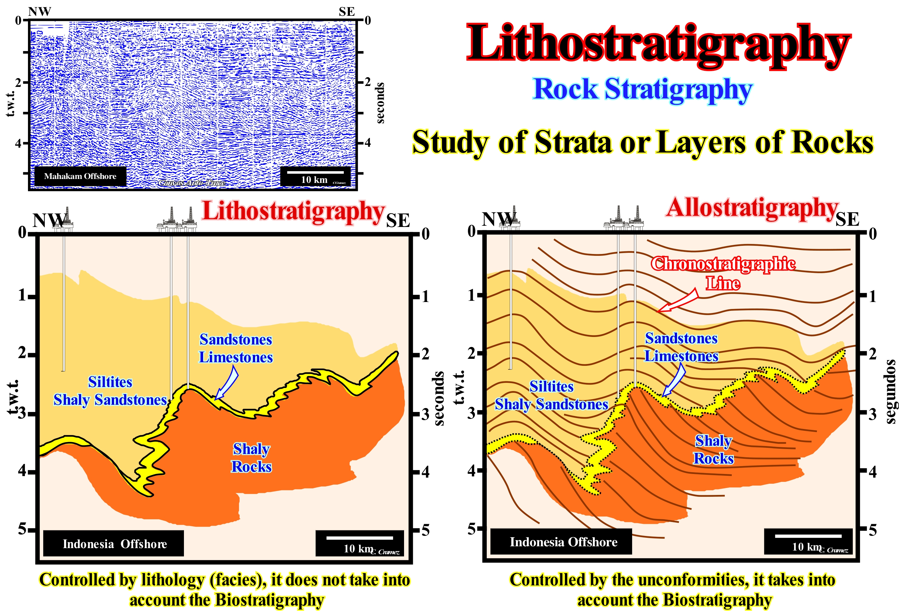
In this figure, two tentative geological interpretations of a Canvas auto-trace of Mahakam (Indonesia, West of the island of Borneo) offshore seismic line, which corresponds to a backarc basin, practically, without oceanic expansion, that is, without a non-Atlantic type divergent margin on top. One of the tentatives (left) was made in lithostratigraphic terms, while the tentative in the right was made in allostratigraphic terms (mapping of the rocky units based on the depositional time). In the first one, the geoscientist tried to map the different facies (lithology with an associated fauna) without taking into account the biostratigraphy. He highlighted three areas with characteristic facies: (i) Siltes and Silty Sandstones, deposited in a vertical succession of delta plains ; (ii) Sandstones and limestones, deposited in a vertical succession of delta fronts of a delta building (not to be confused with a delta) and (iii) Shales deposited in a prograding succession of prodeltas, which in most cases constituted the upper part of the continental slope (when the basin had no shelf), which means that the delta front coincided with the continental edge, which may or may not coincide with the basin edge (take into account the seismic resolution that prevents transgressive seismic intervals of thickness equal to or less than the vertical seismic resolution, i.e., of the order of 20/40 meters). In the allostratigraphic interpretation, the geoscientist mapped not only the different facies, but also the main chronostratigraphic lines. These chronostratigraphic lines, which emphasize the most important seismic reflectors, will allow the geoscientist to recognize, in a second phase of the interpretation, the main seismic surfaces (defined by reflector terminations, i.e., lapouts: onlaps, downlaps and toplaps), and thus recognizing significant relative sea level falls, which are the result of the combined action of tectonics (subsidence or uplift of the sea floor) and the absolute (eustatic) sea level (supposed global and referenced to the Earth's centre). A comparison between these two interpretations makes it, easy, to state that the boundaries of the facies are diachronic and thus oblique to the chronostratigraphic lines (seismic reflectors), which roughly represent depositional surfaces. The abrupt variations of the facies indicate not only episodes of progradation (increasingly important sedimentary regressions induced by increasingly smaller marine ingressions), but also of retrogradation (transgressions, i.e., set of increasingly important marine ingressions and increasingly smaller sedimentary regressions, deposited during the stability periods of relative sea level that occurs after each marine ingression), as well as episodes of negative aggradation, which underline significant relative sea level falls, which mark the location of the unconformities. In fact, an unconformity that is induced by a significant fall of the relative sea level (local sea level referenced to the base of the sediments or to the sea floor and which is the result of the combined action of the absolute or eustatic sea level, which is supposed to be global and referenced to the Earth's centre, and tectonics) can be recognized by a seaward displacement of the shoreline (progradation) and downwards (negative aggradation), which is not the case during the regressions that can be recognized by the seaward displacement of the shoreline (progradation) and upwards (positive aggradation). In the first case, the relative sea level falls significantly, while in the second case it rises in deceleration (marine ingression with smaller amplitude). On a tentative allostratigraphic interpretation, the unconformities correspond to the seismic surfaces defined by the onlaps, which limit the different stratigraphic cycles. On the tentative of allostratigraphic interpretation, the boundaries between the stratigraphic units follow time lines (chronostratigraphic surfaces) and not facies (lithological surfaces) lines. Lithological predictions and, in particular, the most probable reservoir-rock predictions can not be made simply by looking at a seismic line, since they require a precise methodological approach from the scope of what is termed Seismostratigraphy*.
(*) Interpretation in stratigraphic data of the seismic data, considering that the primary seismic reflections are generated by physical interfaces between sedimentary intervals (sets of layers of thickness greater than or equal to the vertical resolution of the seismic lines), characterized by different values of seismic velocity and density (acoustic impedance). Such a stratigraphic interpretation involves the identification of stratigraphic cycles induced by eustatic cycles whose duration determines the order of magnitude, assuming that the rate of variations of the absolute or eustatic sea level is faster than that of the tectonic variations, that is, assuming which is the eustasy that determines the cyclicity of the sedimentary deposits.
Rock System...................................................................................................................................................................................................Système rocheux
Sistema rochoso / Sistema rocoso / Rock-System / 岩系 / Система горных пород / Sistema roccia /
Sequence of events that involves the formation, alteration, destruction and the reformation of the rocks as a consequence of the geological processes. Unlike the rock cycle, a rocky system is an open system and does not return to the starting point (S. Judson & S.M. Richardson, 1995).
See: « Davisian Cycle »
&
« Erosion »
&
« Geological Principle »
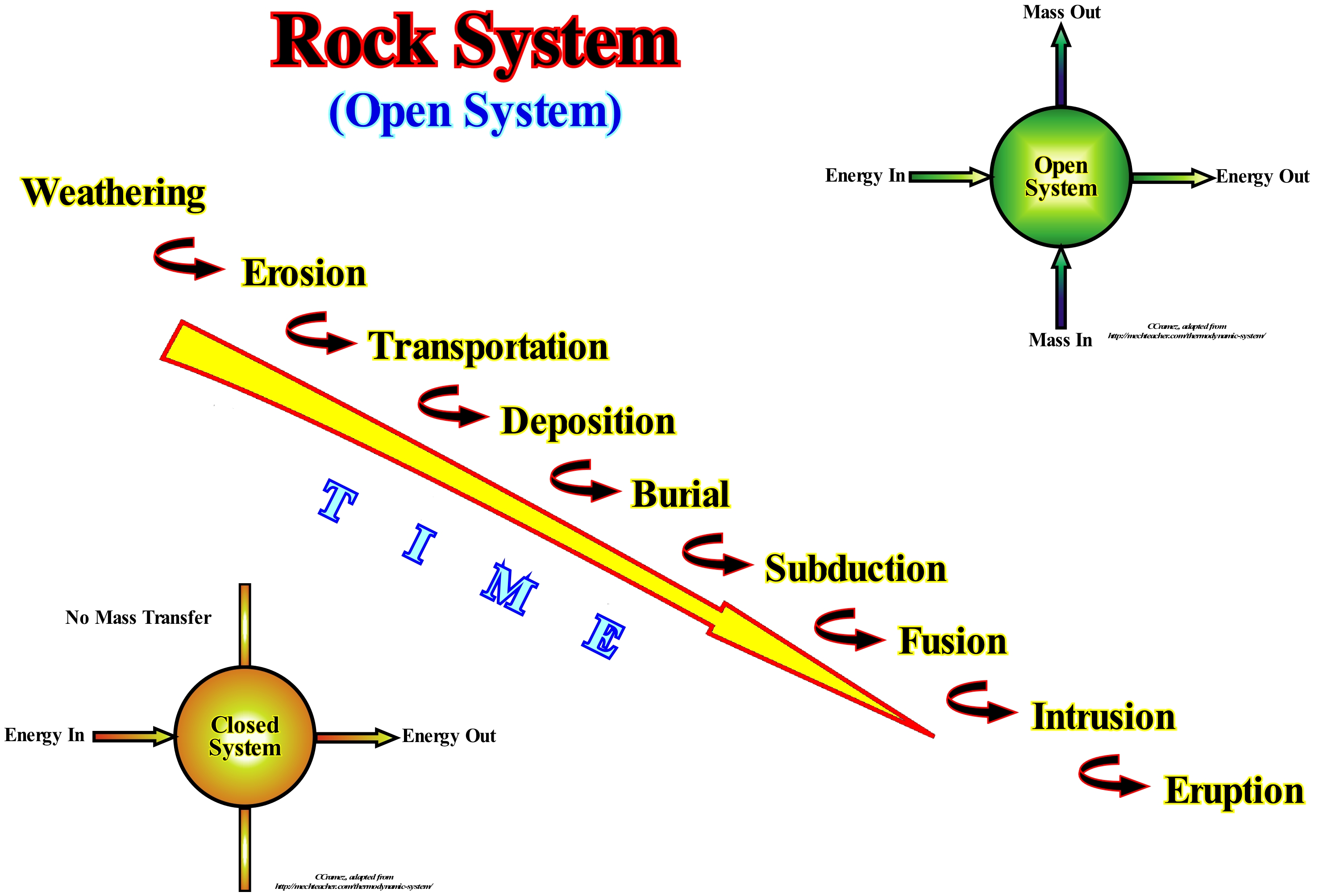
A system is a whole that is made up of several parts. The terrestrial system, for instance, consists of the atmosphere, solid ground, oceans and organisms that live there, which forms a whole that is, continuously, active. The terrestrial system consists of an incalculable number of sub-systems: hydrological subsystem, glacial subsystem, fluvial subsystem, etc., etc. Plate tectonics is also a system, in which pieces of the earth crust (lithospheric plates) move, laterally, over the asthenosphere (the upper part of the earth's mantle, on which the lithospheric plates move, limited, approximately between 30/130 km and 670 km of depth) and interfere with their extremities. Similarly, a rocky system is a system that describes the members of the same family of rocks when they change geological environment and become members of another family. The igneous rocks are destroyed by weathering (natural process of decomposition or disintegration of rocks and soil and its constituent minerals, by the chemical, physical and biological effects that result from its exposure to external agents). The sedimentary particles resulting from this weathering are the bricks or building blocks of the sedimentary rocks. These, in turn, are partially or totally destroyed by weathering or converted into metamorphic rocks (rocks derived from the transformation of igneous or sedimentary rocks, which have undergone a modification of their composition, due to the influence of the environmental conditions in which they were integrated in comparison to the places where they were originally formed). Metamorphic rocks can also be destroyed by weathering, or be more metamorphosed or even fused to form a magma, which can create new igneous rocks. Systems theory says that a system can be opened or closed. Open systems those that undergo interactions with the environment where they are inserted (in an open system there is mass transfer). In this way, a Part generates feedbacks that can be positive or negative, thus creating a regenerative self-regulation, which in turn creates new properties that may be good or bad for the Whole independent of the Parties. Closed systems are those that do not suffer influence from the environment in which they are inserted, in such a way that it feeds on itself (in a closed system there is no mass transfer). When a rocky system is described in a circular (not temporal) manner, it becomes a closed system and then speaks of a rock-cycle. When time is taken into account, the system is opened and in this case it is spoken of a rock-system. Unlike the cycle of rocks, which represents a closed system, a rock-system is open (temporal), once, that it does not return to the starting point. The rock-cycle is a recurrent succession of geological events (physical phenomena, such as a volcanic eruption or an earthquake), which, generally, occurred thousands of years ago, which led to the formation of rivers, lakes, volcanic craters, oceanic pits or mountain ranges, etc. A rock-system is the concept of a temporal sequence of events that comprises the formation, alteration, destruction and reformation of rocks as a result of a number of geological processes. Since such a sequence is here temporal (in the direction of time), the system is open and does not return to the starting point. Of all the planets that make up the solar system, it seems that the rock-cycle exists only on Earth, because the system of lithospheric plate tectonics and that of climate are different from all other planets. On the Moon, for example, there are no sedimentary rocks, since it has no hydrosphere or atmosphere and the climate is very different from the Earth's climate. All the rocks found in Venus have been affected and modified in different ways by the high temperatures and their atmosphere, rich in sulfuric acid, which characterizes their current climate. Likewise, the lack of water and the thin atmosphere of Venus suggest that the weathering and erosion present on the planet March are very different from those of the Earth (https://pt.slideshare.net/YagoVerling/ciclo-das-rochas-4). The presence of abundant water on Earth is of great importance for the cycle of rocks. More perhaps, they are the processes of water for erosion and weathering. Rainfall, flooding of ground and groundwater is quite effective in the dissolution of minerals, especially the igneous, metamorphic and sedimentary marine rocks that are unstable under near-surface atmospheric conditions. Water carries away the dissolved ions in solution and the disaggregated fragments that are weathering materials. Water carries large amounts of sedimentary particles (detritus) through inland hydrographic basins of the rivers that goes to the oceans. (https://pt.wikipedia.org /wiki/ Ciclo_das_rochas)
Rock Waste............................................................................................................................................................................................................Reste de roches
Restos de rochas / Restos de rocas / Reste von Stein / 遗存的岩石 / Обломки горных пород / Resti di roccia /
Angular fragments of a rock, which can form a slope when in sufficient quantity.
See: « Erosion »
&
« Shoreline »
&
« Slope »

In the photograph on the left, the slope formed on the side of the road is, evidently, an accumulation of rock waste, which fell along the longest line of the rocky wall and, gradually, began to accentuate. In the three schemes on the right, where the scale is given by a house, the formation of a slope of rock waste is illustrated. In the upper sketch, there is an almost vertical escarpment with the potential for a rocky block to fall. The cause of such an event may be, an earthquake, movement, weight of an animal or the ice and water melt. Obviously, as common sense suggests, leaning on the edge of a cliff or taking a nap at its base (which often happens on certain the beaches) is not a good idea. The middle sketch, in which a block of rock falls, which occurs without any warning is, rarely, observed. Sometimes a passer-by may hear a block of rock fall to a certain distance, but when he wants to see what has happened, he will only see a pile of rock waste at the base of a cliff. The lower sketch illustrates the rock waste, which form a small slope near the cliff as the fragments accumulate from the base of the cliff. The greater the number of blocks that fall from the cliff, the greater the aggradation and the slope progradation. A rocky flow, which is often referred to by the unscientific term of landslide, is a down-hill movement a set of sediments or rock mass due to the force of gravity. The term "rocky" implies a, more or less, coherent aggregate of sedimentary particles and rocks that begins to move downwards due to the force of gravity and usually in combination with an initiation mechanism such as an earthquake or a rapid erosion at the base of the slope. The term "rocky flow" implies that the cliff or slope is decreasing in size, rapidly, or being eroded slowly. This can happen suddenly with a destructive force important or slowly by a gradual alteration of the Earth's surface. Over time, different types of rocky flows play an important role, either in reducing a mountain on simple rocky mounds or in the widening of a gorge in a long river valley.
Rocky Islet.....................................................................................................................................................................................................................................................Îlot
Ilhota (rochosa)/ Islota / Eiland / 洛基胰岛 / Скалистый островок / Isolotto /
Small rocky island larger than an islet, i.e., that have dimensions that allow the construction of definitive dwellings.
See: « Sand Island »
&
« Shoreline »
&
« Barrier Bar »
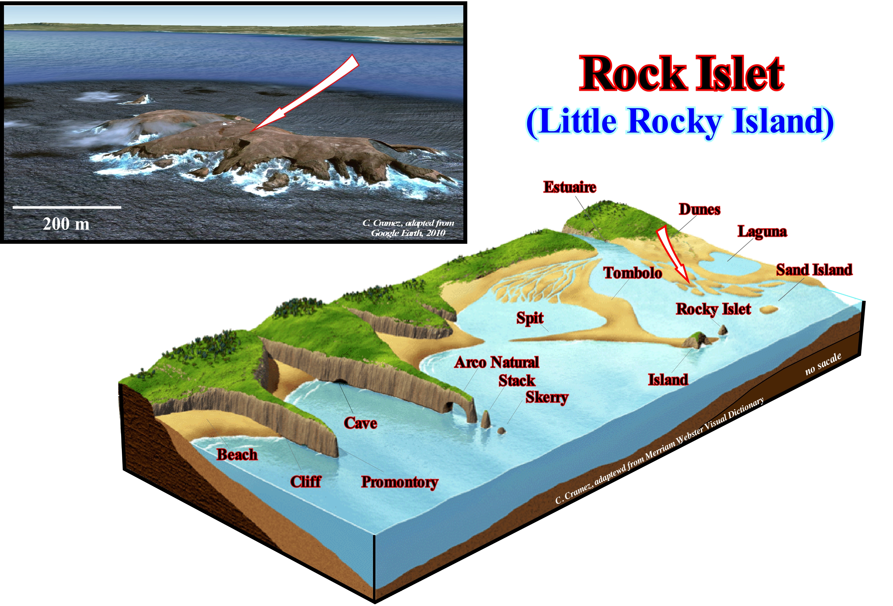
In the western offshore of Portugal, about 9 kilometers away from Cap Carvoeiro, the Berlengas archipelago consists of an rock islet and two skerry, Great Berlenga, Estelas and Farilhões-Forcadas, all geologically different from the coast Portuguese. The Great Berlenga, illustrated in this figure, is about 1500 meters long by 800 meters wide and 85 meters high. The Great Berlenga has an area of 78.8 ha is the unique where one can live. That is why the rock islet name is the most appropriate. In the lower scheme are represented the main coastal morphological elements: (i) Sand island, that the upper part of a sand deposit formed near the coastline ; (ii) Beach, low coastline with detrital, terrigeneous, sandy-silty and coarse sand ; (iii) Cliff rocky wall, very steep, facing the sea ; (iii) Promontory, cape or end of a cliff, i.e., a sharp protrusion of the coast line advanced seaward ; (iv) Caver, a natural subterranean cavity created by a slow dissolution and erosion of the rocks by the sea ; (v) Natural arch, arch pierced by the sea on a cliff near the promontory; (vi) Stack, the rocky spur, high and narrow, which emerges from an erosion platform and is often the result of the collapse of a natural arch; (vii) Stack, a rocky ledge that emerges or, which is almost discovered at low tide, and that during the prey, as a rule, is submerged ; (viii) Spit, a coastal barrier-bar formed by the growth of the foreshorerunnels , with one end free, the tip of the spit, and the other resting on the coast; (ix) Rock Islet, small island, that is, a Earth’s surface emerged and isolated from the mainland ; (x) Laguna, body of sea water, shallow, separated from the sea by a sandy coastline or by a barrier island; (xi) Dunes, accumulations of sand shaped by the wind; (xii) estuary, mouth of a river influenced by the tides; (xiii) Tombolo, which is an extension of sand that joins the island to the coast.

