
Estuary....................................................................................................................................................................................................................................................Estuaire
Estuário / Estuario / Gezeitenmündung / 河口 / Эстуарий (устье реки) / Estuario /
Bay at the mouth of a river formed by subsidence or a rise in relative sea level*. It is the place where the fresh-water of the rivers mixes with the salt-water of the oceans.
See: « Bay »
&
« River »
&
" Coastline »
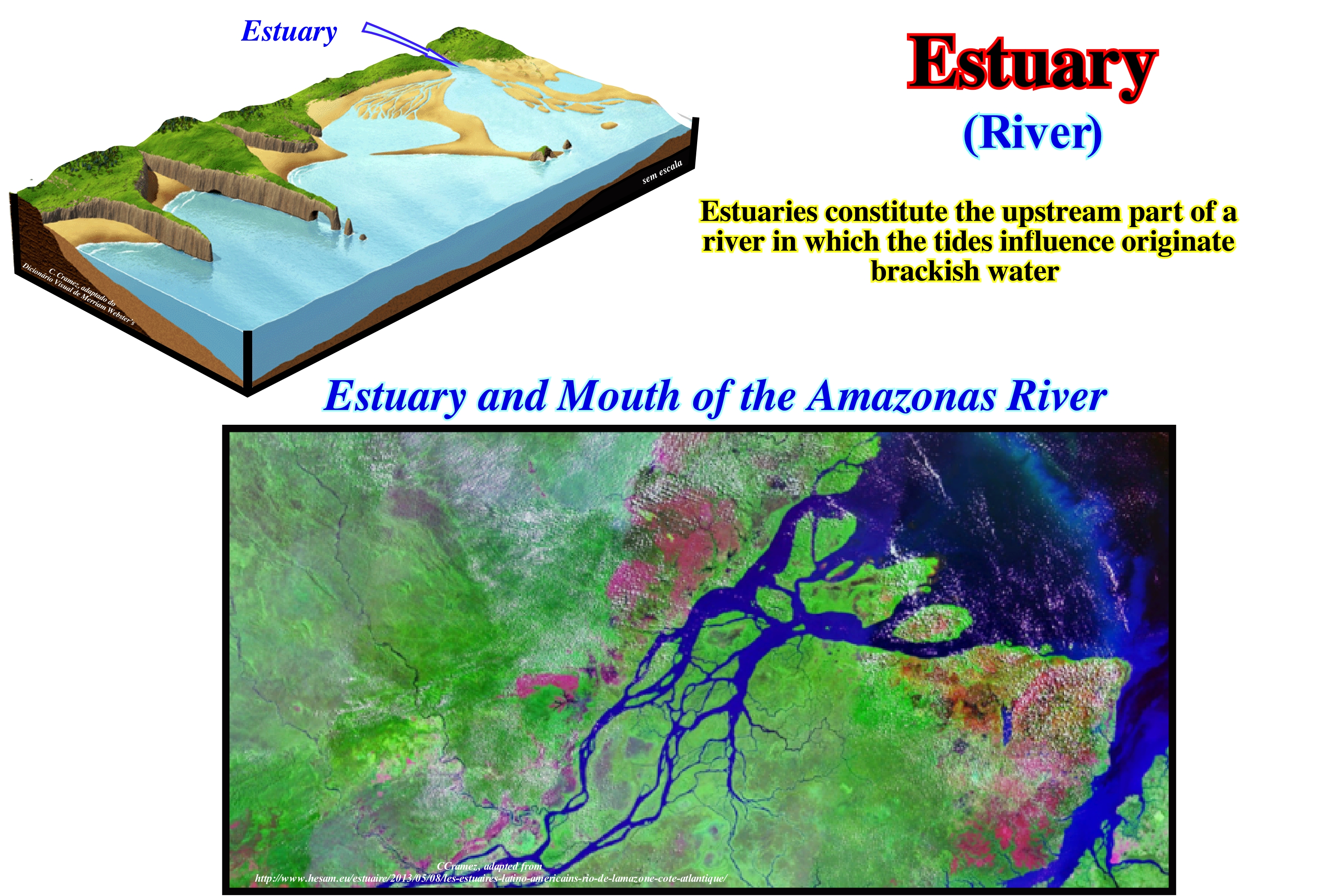
As illustrated in this sketch, an estuary is a mouth of a river influenced by the tides. It forms an indentation at the shoreline and can vary in width, as well as, depth. It is the place where fresh-water comes in contact with sea-water. An estuary is, sometimes, defined as a portion of the ocean or an arm of the sea, which is contaminated by fresh-water. Locally, an estuary can be synonymous with ria-coast or fjord. As estuaries, generally, correspond to river mouths influenced by tidal action, in most cases they are characterized by the sedimentation of silts transported from the mainland by rivers or from the offshore by tidal currents. Brackish water (saltier than river water, but less than sea-water) is predominant in most estuaries. As ecosystems, estuaries are threatened by human activity and pollution, as well as, in some cases, by very intense fishing. Estuaries are marine environments whose pH, salinity and water level depend on the river that feeds them and on the ocean from which their salinity derives. The time required for an estuary to complete its cycle is called Levelling Time. In its simplest form, the levelling time (tf) can be defined as the time required to drain a volume V through an inlet A with a current velocity v or, in other words, the time required to replace the volume of water Vf at the rate of flow through the estuary, which is given by the discharge rate of the river R: tf = Vf / R. The circulation of water in the estuaries is very frequent and almost always typical. It occurs when fresh or brackish water flows downstream near the surface, while the denser salt water flows upstream along the bottom. There is also an "antiestuary" circulation, which is done in reverse. The denser salt-water flows downstream along the bottom and the less denser fresh or brackish water flows upstream near the surface. Estuaries are especially frequent on the submerged coasts where the sea level has risen relative to the land, which causes the flooding of the valley creating ria-coasts and fjords.
(*) Relative sea level is the result of the combined action of absolute (eustatic) sea level and tectonics (subsidence when the sediments are lengthened or uplift when the sediments shortened, although in certain cases, when there is diapirism, the sediments can be lengthened). Relative sea level is local and referenced to any point on the Earth's surface (sea floor or base of the sediments, i.e., top of the continental crust). The absolute or eustatic sea level is supposed to be the global and referenced to the Earth's centre. Absolute or eustatic sea level is dependent on : (i) Tectono-Eustasy, which is controlled by the volume changes of the ocean basins in association with oceanic expansion (sea floor spreading) following the supercontinent break-ups ; (ii) Glacio-Eustasy, which is controlled by the changes of ocean water volume, function on the amount of ice ; (iii) Geoidal-Eustasy, which is controlled by the distribution of ocean water caused by variations in the terrestrial gravity field and (iv) Thermal Dilation of the oceans or steric sea level rise.
Estuary Apex (Head of the tide)...........................................................................................................................................Apex de l’estuaire
Ápice do estuário / Limite de marea, Ápice del estuario / Flutgrenze / 河口的顶点 / Вершина устья реки / Apice dell'estuario /
The most upstream point reached by the tide of salinity (tidal current that penetrates the mouths of the waterways).
See: " Estuary "
ETP Curve..............................................................................................................................................................................................................................Courbe ETP
Curva ETP / Curva ETP / ETP-Kurve / ETP曲线 / Кривая прецессионных отклонений / Curva ET /
Graphical representation of the combined effects of eccentricity, obliquity and precession during a given geological period, at a given latitude (generally 65° N). The amount of solar radiation received on Earth's surface, based on variations in Earth's orbital movements.
See: « Milankovitch's Theory »
&
« Milankovitch's Cycle »
&
« Astronomical Theory of Paleoclimate »
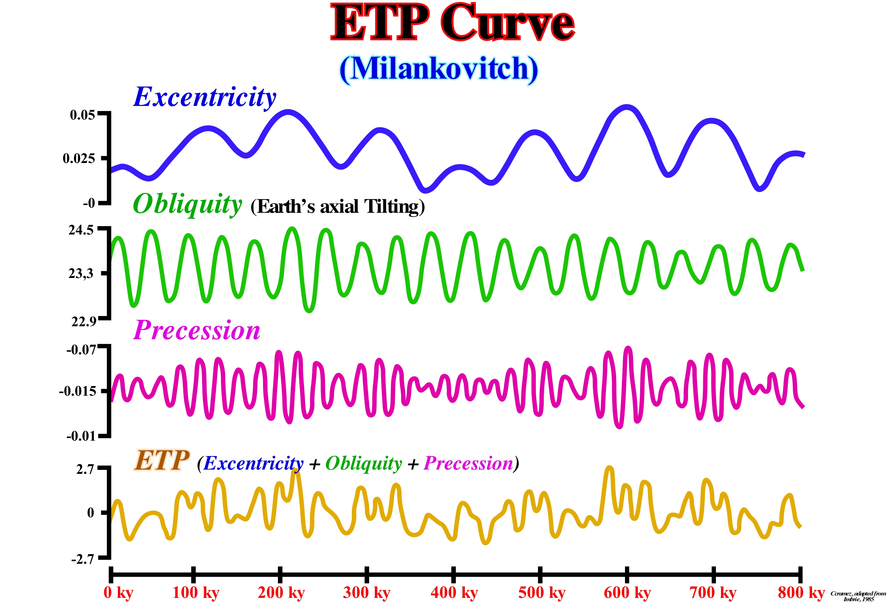
Either eccentricity (the shape of the Earth's orbit around the Sun) or the obliquity (variation of the inclination of the axis of rotation of the Earth) or precession of the equinoxes (retrograde motion of the equinox points since the axis of rotation of the Earth rotates as a top, i.e., spinning top) are capable of causing important climatic changes. When the obliquity is small (axis of rotation of the Earth is almost normal to the ecliptic, which is the apparent path the sun makes in the sky during a year), more solar energy is supplied at the equator than at the poles. That creates a strong temperature gradient and less changes between seasons. The precession variations alter the structure of the stations cycles. They move the perihelion (the point of the Earth's orbit that is closest to the Sun, where it has the highest translation velocity of its entire orbit) along the orbit, which changes the Sun/Earth distance in each season and thus the intensity of the sunshine. As all effects associated with these factors have different periods it is clear they are not in phase. The great scientific contribution of Milan Milankovitch was to demonstrate, without computers, the relations between the different phases of these effects from a fantastic mathematical calculation. As illustrated in this figure, the combined effects of these three factors, i.e.: (i) Eccentricity ; (ii) Obliquity or Tilting (rotation axis) and (iii) Precession, for a latitude of 65 ° N, are obvious in the ETP curve (acronym of Eccentricity, Tilting, Precession) Such a curve is the combined effects Eccentricity, Obliquity and Precession curves during a given geological period, to a particular latitude, whose vertical scale is in units of standard deviation (a measure of the dispersion around the population mean of a random variable). Recent stratigraphic studies and isotopic geology (in particular the use of oxygen isotopes contents) corroborate the existence of a correlation, more than probable, between the curves of temperature variations (and other parameters) with the Milankovitch curves for the last 800 ky. Contrary to modern climatology, which is based on a large number of observations made in a short time interval and does not claim to study climate change, paleoclimatology has this faculty, but unfortunately, from a limited number of comments. That is why we should not confuse time (weather) with climate and, above all, with climate change, as certain "new" ecologists regularly do. The time (weather) usually refers to daily changes in temperature and precipitation. The climate, whose main tool is statistics, refers to the average atmospheric conditions that occur in the Earth's atmosphere over a longer or longer time period*. Climate change translates Earth's climate, which is always changing for hotter and colder periods, each of which can last thousands of years. For decades, the hypotheses advanced by Milankovitch were heavily criticized. However, Hays et al. (1976) demonstrated that the astronomical frequencies were well present in paleoclimate data (assuming that the climatic system has a linear response to orbit induction, (http://sigep.cprm.gov.br/glossario/textos/ Cicloestratigrafia _e_Milankovith.pdf). From cores of sea floor, containing a continuous record of about 450 ky, they analyzed three parameters sensitive to climate change by transforming them into geological time series: (i) Oxygen isotope composition (δ 18O) of planktonic foraminifera; (ii) Estimation of summer temperatures to the surface of the sea, based on radiolaria and (iii) Abundance of other species of radiolaria. The numerical techniques of spectral analysis used were developed to look for evidences in the frequencies of variation of the obliquity and the precession. In the intensity spectra, they found almost periodic cycles corresponding to the orbitals. However, although of the presence of the periods of 42 ky and 19 ky and 23 ky, representing, respectively, the obliquity and the precession, the dominant cycles in all the analyzed spectra varied between 94 Ky and 122 ky, i.e., the period of eccentricity. This cycle had not been taken into account at the time of the development of spectral analysis, but had appeared naturally, as a strong evidence of its importance in inducing glaciations, an idea that had already been developed at the time. They concluded induction due to eccentricity could not result from a linear response of the climate system. Its effects caused by the modulation that this cycle would provoke in the precession cycle, which has a proportional amplitude. One response to this modulation would be the observed in the ice sheets. The induction induced by precession would imply a longer glacier thickening time than thinning. The thickening time would be proportional to the 100 ky cycle, with a rapid thinning of some thousands of years.
(*) An average whether it is sea level or temperature, to have meaning it must cover a rather long period. The World Meteorological Organization (WMO) recommends that it covers 30 years: from there one can speak of « normal ».
Eukaryota...................................................................................................................................................................................................................................Eucaryote
Eucariotas / Eucariota / Eukaryoten / 真核生物 / Эукариотный организм / Eukaryota /
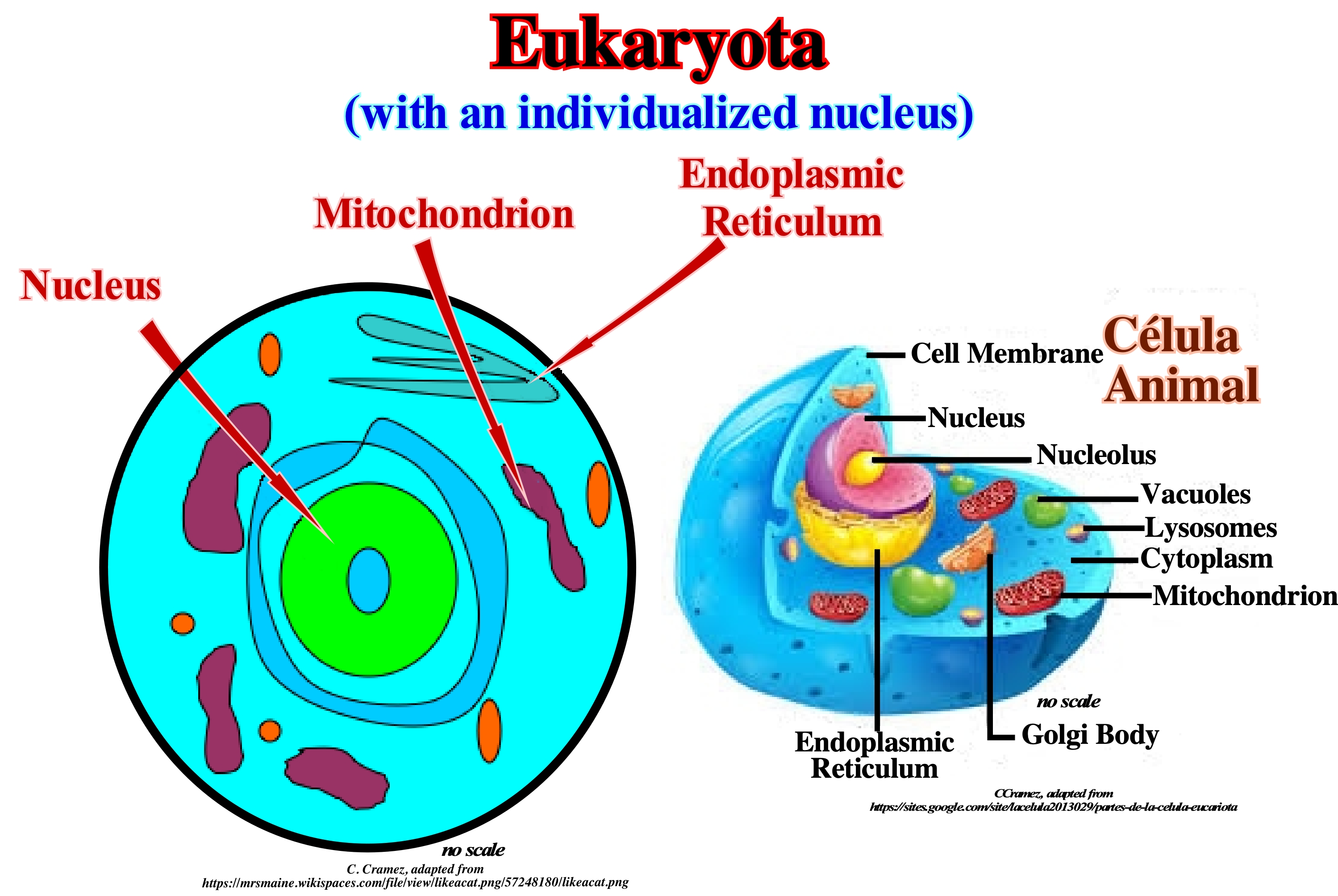
Cell that has its hereditary material (genetic information) inside a membrane (double), called nuclear envelope, that delimits a cellular nucleus.
See: « Eukaryotes »
&
« Animalia (kingdom) »
&
« Photosynthesis »
Eukaryotes range from single-celled organisms to gigantic multicellular organisms in which cells differentiate and perform different functions without being able to live in isolation. Eukaryotes share the same origin, and so are grouped into a higher taxonomic hierarchy than the Kingdom, that is, a Domain or Empire, depending on how geoscientists view the origin of eukaryotes. The following kingdoms are part of this category of living beings, i.e., the "Eucaryota Empire": (i) Kingdom of animals ; (ii) Kingdom of plants ; (iii) Kingdom of Fungi; (iv) Kingdom of Unicellular and Protozoal Algae (Protista) and (v) Kingdom of Chromists. This last kingdom is, actually, one of the six kingdoms of living beings proposed by Cavalier Smith (1988). It encompasses several groups of Algae with Chlorophyll * A and C. Living forms that are not part of the Eucaryotic Domain or Empire are bacteria and archaea (formerly called archaebacteria), that is, living beings with prokaryotic cells. Eukaryotes appear to be monophyletic, thus composing one of two domains of life. The other domain or empire, that of the bacteria and archaea, is made up of prokaryotes. Eukaryotes share some aspects of their biochemistry with archaea, so some authors group them with archaea to form the Neomura clade (hypothetical ancestor of the Archaea and Eukaryota domains), which is a very diverse group containing all multicellular species and all extremophilic species. All of these species share certain molecular characteristics. All Neomorians use the methionine molecule ** as the amino acid initiator for protein synthesis, while bacteria use formylmethionine. In any case, it can be said that all neomurians use different types of polymerases, whereas bacteria use only one. Cavalier-Smith showed the Neomura clade evolved from bacteria since they possess mitochondria, which evolved, certainly, by endosymbiosis from an alpha protobacterium. If eukaryotes are as old as bacteria, they would have branched over the millions of years needed for bacteria to develop aerobic respiration.
(*) The different forms of chlorophyll (from a to f) are unevenly distributed in the diversity of oxygenated photosynthesizers. Chlorophyll a is in all cases linked to the active centre of molecular complexes called photosystems, which absorb light during photosynthesis. It differs from chlorophyll b in that the 3-position radical of the tetrapyrrolic group is -CH3 (methyl) rather than -CHO (aldehyde functional group).
(**) One of the amino acids (carbon (C), hydrogen (H), oxygen (O) and nitrogen (N)) encoded by the genetic code (relationship between base sequence in DNA and corresponding amino acid sequence in protein) being It is therefore one of the protein components of living beings, with the exception of prokaryote bacteria.
Eukaryotes (Eukaryota).............................................................................................................................................................................................Eucariota
Eucélula / Eucélula / Eukaryoten / 真核生物 / Эукариот / Eukaryota /
Another name for eukaryotic cells or eukaryota. The term eukaryota, in Greek, means true cell. Synonym of eukaryota.
See: « Eucaryota »
&
« Photosynthesis »
&
« Protokaryota »
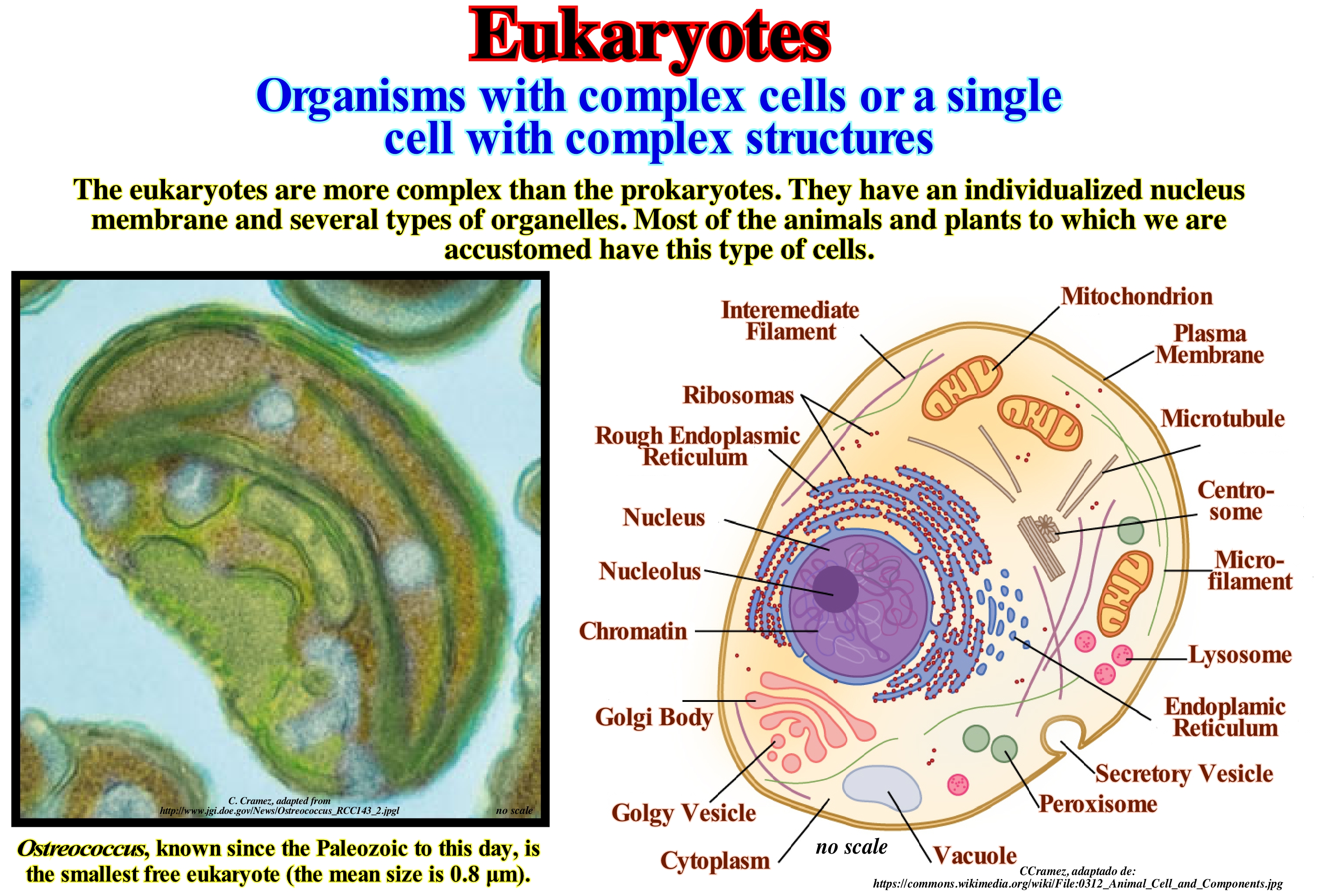
Eukaryotes (or eucells) comprise of all the kingdoms of the life, except the Monera kingdom. They can be, easily, recognized by the membrane-bound nucleus. The eukaryotes contain, also, many other structures inside the membrane called organelles. These organelles such as mitochondrion or chloroplasts serve to exert metabolic functions and energy conversions. Other organelles such as intracellular filaments provide structural support and motility (ability to move): (i) Cell Membrane defines the first cell and evolves to become the repository for surface receptors and surface antigens (particle or molecule capable of initiating an immune response, which begins with recognition by the lymphatics, leukocytes or white blood cells, which have the function of combating disease-causing microorganisms by means of their capture and cumulates with the production of a specific antibody) ; (ii) Cell Wall, formed by plant cells that have a rigid layer of the cell wall instead of the more flexible cell membrane (it is this rigid wall of the plant cells provides a firm structure) ; (iii) Cytoplasm, where thousands of signals are sent back and forth through the organelles and where most of the cellular organelles are located : (a) Mitochondrion, which is composed of four main elements: - the outer membrane, - the inter-membrane space ; - the inner membrane and -the matrix) ; (b) Chloroplasts which are, basically, the organelles responsible for photosynthesis, they are, structurally, very similar to mitochondrion ; (c) Endoplasmic Reticulum, which is responsible for the production of protein and lipid components of most of the organelles of the cell ; (d) Golgi Body, which is composed of numerous sets of smooth cisterns, which are coated with lipid membranes ; (e) Lysosomes, which are membranous pocket containing hydrolytic enzymes used to digest macro-molecules ; (f) Cytoskeleton, which corresponds to a network of cytoplasm protein filaments and vacuoles (just in plant cells responsible for maintaining the cell shape and structure) ; (iv) Nucleus, which is the centre of all activities within the cell ; it is in the nucleus where all the genetic information is located.
Eukaryotic (Cell)....................................................................................................................................................................................Eucariotique (Cellule)
Eucariotica / Eucariótica (célula) / Eukaryotische / 真核生物 / Эукариотический / Negli eucarioti /
A cell that has a membrane around the nucleus and that makes up all the organisms of the living kingdoms, except for the monera kingdom.
See: « Eucaryota »
&
« Animalia (kingdom) »
&
« Protokaryota »

As illustrated in this sketch, a eukaryotic cell has a true nucleus (defined and protected by the nuclear envelope), which contains one or more nucleolus. These cells have a highly compartmentalized cytoplasm with separate or interconnected cell organelles limited by biological membranes having the same essential character of the plasma membrane. The nucleus is the most notable and characteristic of the compartments into which the protoplasm (the active part of the cell) is divided. In the protoplasm there are three main components: (i) Plasma Membrane; (ii) Nucleus and (iii) Cytoplasm. Eukaryotic cells have in the cytoplasm a complex, well-structured and dynamic chitinous skeleton composed of micro-tubes and filaments of different proteins. It may also have a cell wall, which is typical of multicellular plants, fungi and protists, or another type of external plasma coating. In comparison to eukaryotic cells, prokaryotic cells are relatively simple. These are cells found in bacteria and cyanophytes (blue algae or cyanobacteria). In eukaryotic cells, nuclear division is, often, associated with cell division. This, usually occurs by mitosis (a process that allows each child's nucleus to receive a copy of each chromosome). In most eukaryotes, there is also a process of sexual reproduction involving, generally, an alternation between haploid generations (only one copy of each chromosome is present) and diploid generations (two copies are present), is produced by nuclear fusion (syngamy) and meiosis (division process, in which the number of chromosomes per cell is divided into two). In animals, meiosis results, always, in the formation of gametes* or sex cells, whereas in other organisms it may result in spores. Eukaryotic cells have a smaller surface area in relation to the volume of prokaryotes and thus lower metabolic rates and longer generation time. In some multicellular organisms, specialized cells for metabolism increase the surface of certain areas, such as in the intestines.
(*) Cells of living beings that, in sexual reproduction, merge at the time of fertilization.
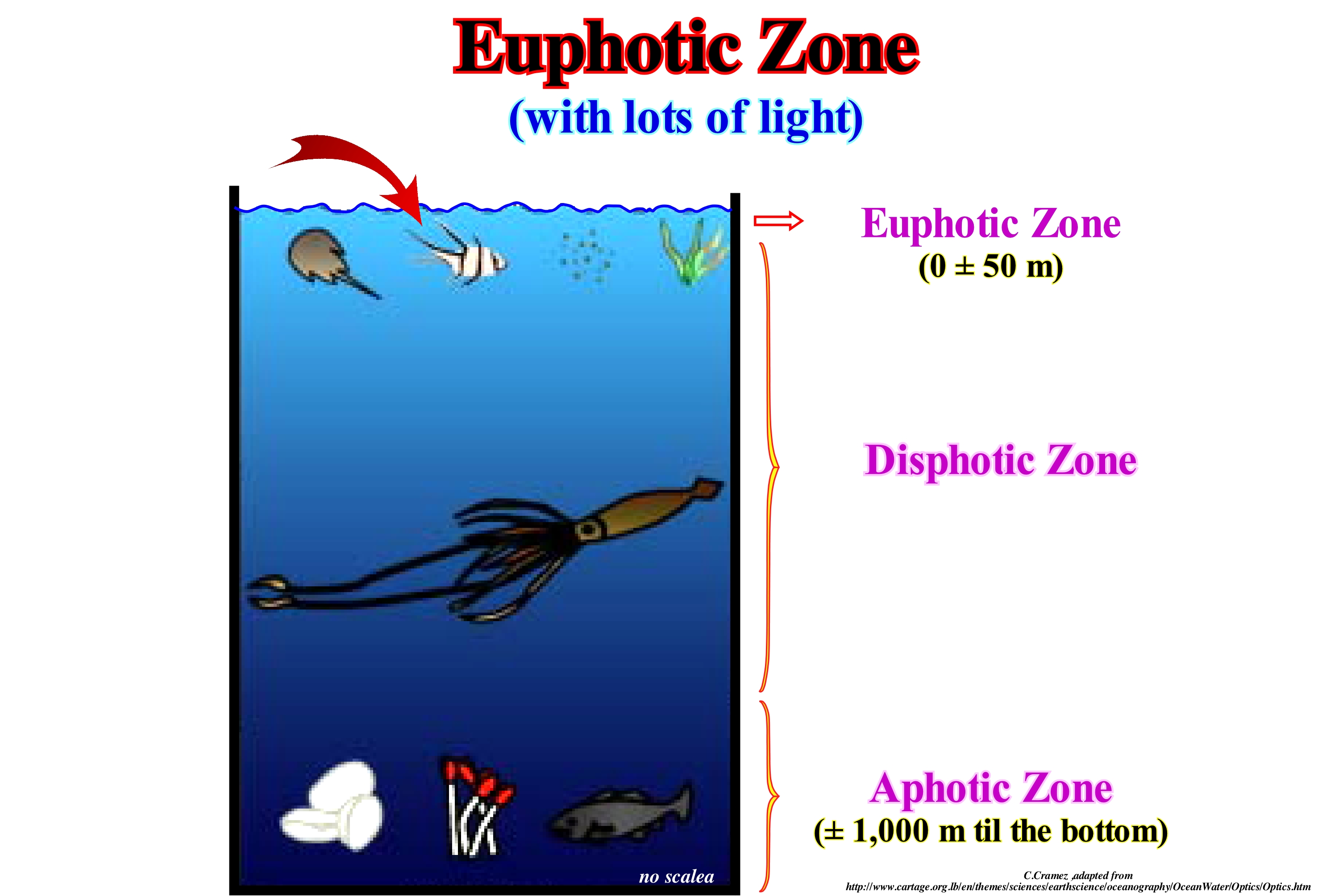
Euphotic Zone...........................................................................................................................................................................................Zone euphotique
Zona eufótica / Zona eufótica / Euphotischen Zone / 透光层 / Эвфотическая зона / Zona eufotica /
Water-depth of an ocean or lake between the surface and a depth of about 50 meters, depending on the time of year, time of day, water clarity and the presence of clouds. It is the watercolumn of the ocean where there is enough sunlight for the plants to carry out photosynthesis. All plankton, "vareque" (all seaweed family of algae) and plankton are found in the euphotic zone.
See: « Aphotic Zone »
&
« Disphotic Zone »
&
« Photic Zone »
The euphotic zone is the upper layer of the oceans that is bathed in sunlight during the day. This zone is also called light or epipelagic zone. The depth of the euphotic zone, that is to say, the passage to the dysphotic zone depends on the water transparency. When the water is clear, the euphotic zone can be very thick. The euphotic zone is defined in terms of light and not in terms of depth. In this area, sunlight is sufficient for photosynthesis to take place. Many plants and other photosynthetic organisms live in the euphotic zone, where food is abundant. Because photosynthesis is a process by which sunlight and carbon dioxide (CO2) are converted into food (chemical energy contained in carbohydrates) and oxygen. Euphotic zone creates about 90% of the Earth's oxygen. Most of this oxygen is produced by phytoplankton. These primary carbohydrate producers, which certain geoscientists call autotrophs, are the first link of the food chain in the oceans. That is why many animals live in the euphotic zone. Most of the life in the oceans is found in this area, although it is the smallest zone in terms of volume of water. The living beings of an ecosystem can be divided into autotrophs and heterotrophs. Most autotrophs (algae, vegetation, and certain bacteria) photosynthesize. Animals, fungi, protozoa and most bacteria are heterotrophs. They need to get food (organic substances) from other living things or their products. Autotrophic organisms are at the base of food chains. The vast majority of the animals living on the sea floor live in the euphotic zone, which is defined in terms of light and not in depth.
Euryhaline (Organism)...............................................................................................................................................................................................Euryhalin
Eurialino / Euryhalino / Euryhaline (Lebewesen) / 广盐性(众生) / Эвригалинный (организм) / Eurialine /
Organism capable of living in marine environments with very different salinities.
See: « Depositional Environment »
&
« Sedimentary Environment »
&
« Saprotroph (organism) »
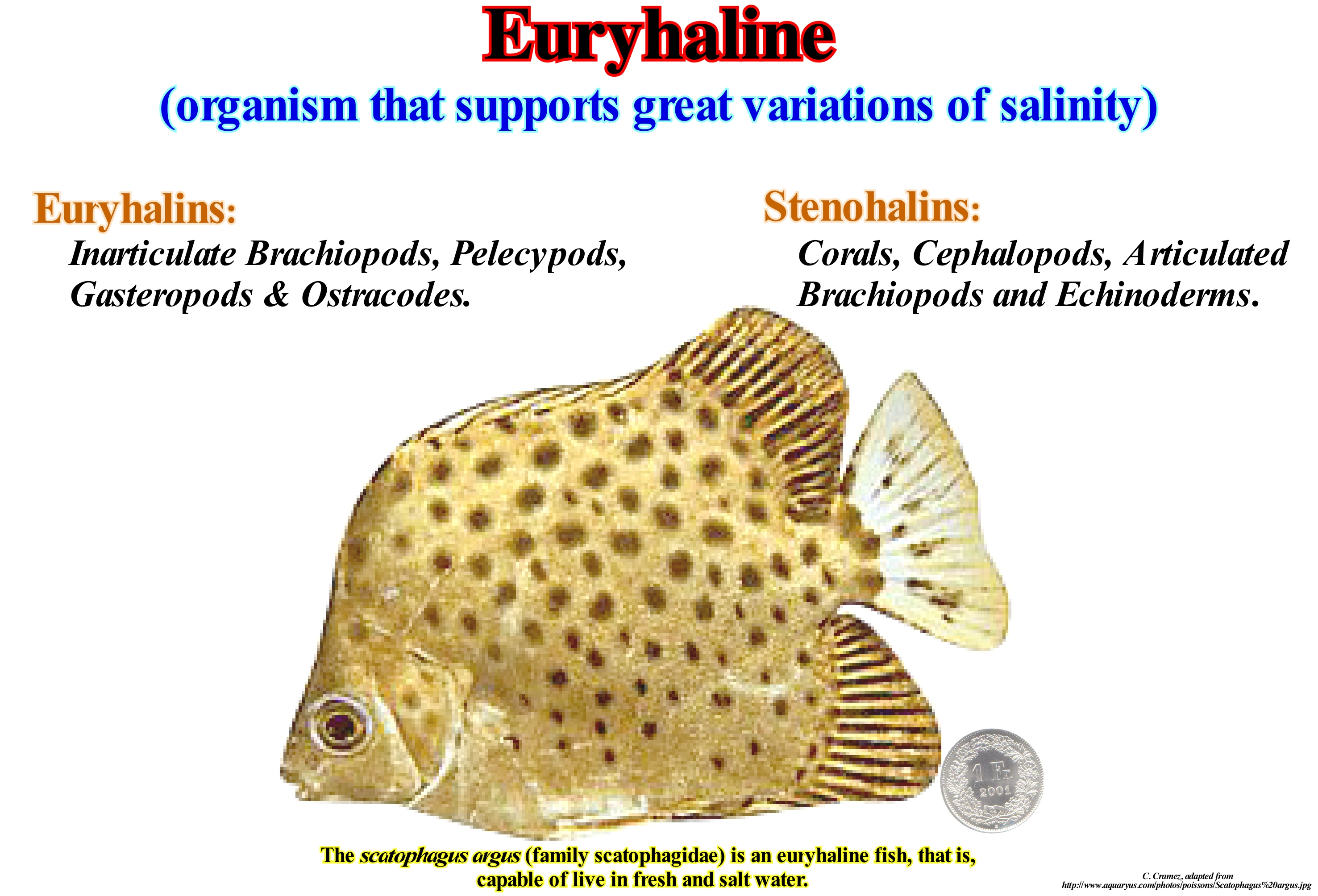
An euryhaline organism is able to adapt to a wide range of salinities. An example of an euryhaline fish is Mollienesia or moli (Poecilia sp.), which can live in fresh, brackish or salt water. The crab of European coast (Carcinus maenas) is an example of euryhaline invertebrates that can live in salt water and brackish water. Euryhaline organisms are often found in estuaries and tide pools, where salinity changes change regularly. Some organisms are euryhalines because their life cycle involves the migration between fresh-water and marine environments, as, for example, is the case of salmon and eels. The opposite of the euryhaline organisms, that is to say, the stenohaline organisms are those that can only survive within a certain salinity. Most freshwater organisms are stenohaline, and therefore die at sea. In the same way, the vast majority of marine organisms can not live in fresh-water. Two important aspects of the mechanisms used by cells to control intra-cellular water and thus to survive an osmotic efforts (which allows water to enter the cell) have been discovered during the last few years. First, there is evidence that marine animal cells traditionally do not have osmolytes (small organic molecules that have been selected to counterbalance environmental efforts in living organisms). In many cases the environmental efforts threaten the conformational stability (for the purpose of determining the different possible conformations of a molecule) of the proteins and therefore, several osmolytes have been selected in order to stabilize intracellular macromolecules of small molecular weight organics, such as, for example, free amino acids, since they have inorganic ionic components regulate cell volume following an osmotic stress. Second, the cells of some invertebrate species are extremely salinity tolerant. Intracellular organic osmolytes, which are quite different from free aminoacids, are generally found in less euryhaline species. As an example of euryhaline organisms we can mention: herring, lamprey, salmon, sturgeon, etc.
Eustasy (Eustatism, eustacy)...........................................................................................................................................................................................Eustasie
Eustasia / Eustasia / Eustasy, Meeresspiegel / Eustasy, 海平面 / Эвстазия / Eustasy, Livello del mare, Eustatismo /
Eustasy's abundant number of definitions is significant in the difficulty of finding a consensus. Eustasy or Eustatism is, often, defined as “simultaneous and global sea level variations”, differentiated from local relative sea level variations. Sea level variations regardless of their causes or global sea level changes measured from the center of the Earth and induced by changes in ocean basin volume (1.2-1.5 cm / 1,000 years).
See: « Relative Sea Level Change »
&
« Geoidal Eustasy »
&
« Subsidence »
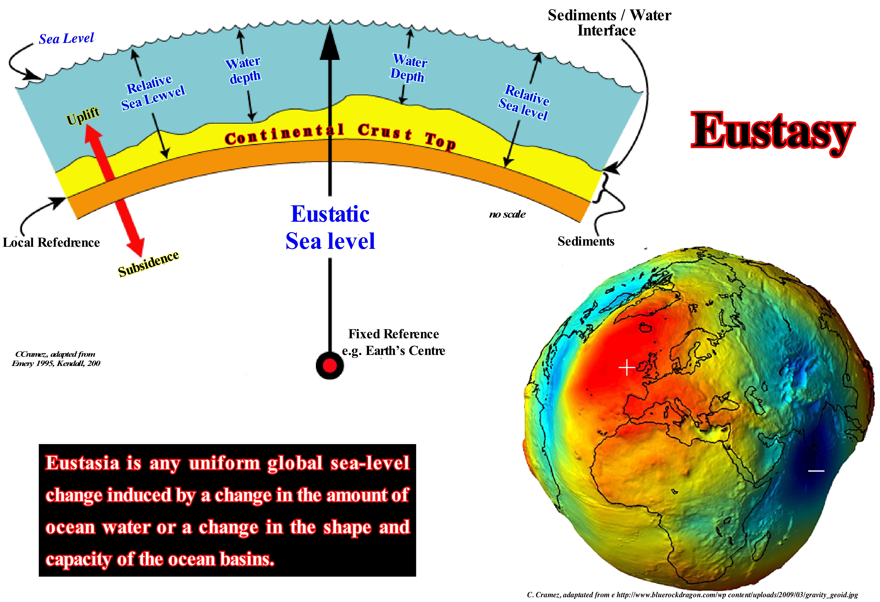
Eustasy can be defined as the variations of the absolute (eustatic) sea level, which is referenced to the Earth's centre. Several variables may induce changes in the volume of ocean basins. The most important seems to be the rate of ocean expansion or sea floor spreading. A rapid rate of sea floor spreading produces huge oceanic mountains with an important topography. On the contrary, a slow sea floor spreading rate produces oceanic mountains with weak relief. During periods of rapid sea floor spreading, the ocean basin are not too deep and the absolute (eustatic) sea level floods the continents since the volume of the basins decreases (assuming a constant volume of water, in all its forms, since the Earth formation). During periods of slow sea floor spreading, the ocean basins are much deeper and, as a consequence, the absolute sea level is forced to withdraw from the continents. Other factors contribute to the volume variations of the ocean basins, such as: (i) Collision between continents ; (ii) Subduction zones ; (iii) Submarine volcanism ; (iv) Sediment filling, etc. Eustasy is dependent on: (i) Tectono-Eustasy that is controlled by the volume variation of the ocean basins in association with oceanic expansion following the break-up of the supercontinents ; (ii) Glacio-Eustasy, which is controlled by the volume of water in the oceans as a function of the amount of ice (assuming that the amount of water in all its forms is constant since the formation of the Earth, about 4.5 Ga) ; (iii) Geoidal-Eustasy which is controlled by the distribution of ocean water caused by variations in the Earth's gravity field (where gravity is stronger than normal, sea level is thrown to the Earth's centre) and (iv) Steric rise of the sea level or thermal expansion of the oceans, which is controlled by the temperature increase of the oceans (if the temperature of the oceans increases, the density of the water decreases and, for a constant mass, the volume increases). The globe illustrated in this figure was constructed with the data obtained from the GOCE* (Gravity field and steady-state Ocean Circulation Explorer) emphasizes the values of the gravimetric gradients, which allowed to propose a global model for the gravitational field and for the geoid. They indicate that sea level is not flat. The amplitude of the undulations (gravity anomalies) is exaggerated by a factor of 100,000 with respect to the Earth's radius. Likewise, sea level profiles show very marked irregularities. Highs and lows exist in association with gravity anomalies. Where the force of gravity is higher, the sea level is lower and where it is lower the sea level is higher. Between the high level of the sea, near New Guinea, and the zone where it is lower (near the Seychelles), there is a difference of about 180 m. A boat sailing between these two areas, along an equipotential surface of gravity, would not consume energy. The present-time configuration of the geoid is, of course, not stable. It must have changed with the variations of gravity and factors controlling it through geological time. The lateral variations of gravity anomalies are related to the anomalies of the distribution of density within the Earth. In sequential stratigraphy, when a geoscientist considers change in relative sea level, they should take into account the local variations induced by gravity anomalies. The relative sea level is local and referenced to the base of the sediment (as shown in this figure) or to the sea floor. It is the result of the combined action of absolute (eustatic) sea level (supposed global and referred to the Earth's centre) and tectonics (subsidence or uplift of the sea floor). An absolute or relative sea level fall may, in a certain area, shift the geological conditions from highstand to lowstand (sea level lower than the basin edge), with development of type I unconformity. In another area, the same sea level fall (absolute or relative) may just induce a type II unconformity (the sea level stays higher up than the basin edge). In sequential stratigraphy, eustasy or eustatism **, i.e., absolute (eustatic) sea level change is considered the parameter responsible for the cyclicity of sedimentary deposits. Tectonics, and particularly subsidence, is the parameter responsible for the most part of the available space for sediments (accommodation). If there is no eustatic variation (water-depth change independent of subsidence or a uplift), a continuous subsidence of the sea floor produces a progressive increase in the available space for the sediments, which may be partially or totally filled by sediments. The water-depth increases, but any unconformity is formed. An unconformity is formed by the combined action of eustasy and tectonics (subsidence or uplift), which produces a significant relative sea level fall. As the cyclicity of eustasy is much faster than tectonic changes, it is almost always the eustasy that makes available the available space in a cyclical way, creating erosional surfaces (unconformities), which bound the stratigraphic cycles. When a geoscientist speaks of eustatic changes or eustatism, he is speaking of absolute (eustatic) sea level changes, which are measured in relation to the Earth's centre and not of relative sea level changes, which are, generally, referenced the sea floor or to the base of the sediments (top of the continental crust). In conclusion do not confuse relative sea level change with absolute or eustatic sea level change.
(*) The Gravity field and steady-state Ocean Circulation Explorer (GOCE) was the first of satellites of the ESA's Living Planet Program planned to map the Earth's gravity field in unprecedented detail. The satellite's main instrumentation was a highly sensitive gravity gradiometer consisting of three pairs of accelerometers that measured gravitational gradients along three orthogonal axes. The GOCE mapped the deep structure of Earth's mantle and probed dangerous volcanic regions. It has brought new insights into the behaviour of the oceans. By combining gravity data with information on sea surface height collected by altimeters from other satellites, geoscientists were able to track the direction and velocity of geostrophic ocean currents. The system's low orbit and high precision have considerably improved the known accuracy and spatial resolution of the geoid (theoretical surface of equal gravitational potential on Earth, (https://en.wikipedia.org/wiki/Gravity_Field_ and_Steady-State_ Ocean_Circulation_Explorer ).
(**) Certain geoscientists consider that eustatism is the variation of middle sea level, which seems to us a bit abusive. In the oceans, the middle sea level is considered to be, roughly, equal to the geoid. In continental areas, they can be very different. Sea level varies, greatly, in time and space. It is affected by tides, wind, atmospheric pressure, local gravity differences, temperature, salinity, subsidence, etc. To determine the "middle sea level", the best thing to do is to determine a place and calculate the average level at that point and use it as a reference point. Generally, such a calculation made from hourly observations, made over a period of about 30 years.
Eustasy (Metaphor)........................................................................................................................................................................................Eustasie (Métaphore)
Eustasia / Eustasia (metáfora) / Eustasy, Meeresspiegel / Eustasy (隐喻), 海平面 / Колебания уровня моря под влиянием вращения земли / Eustasy (Metafora), Livello del mare, Eustatismo /
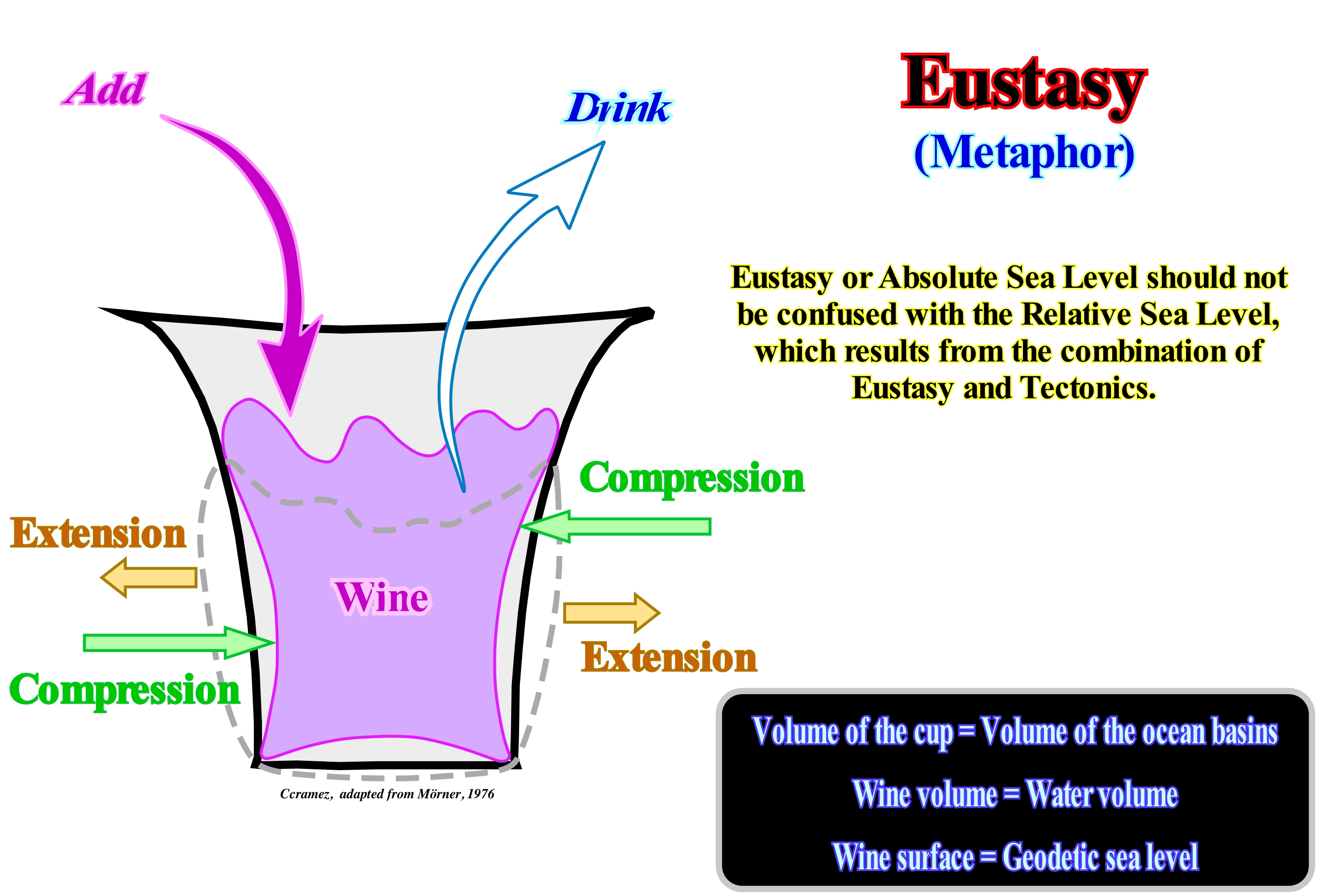
Eustasy can be illustrated by variations in the level of wine in a rubber cup. The size of the glass simulates the volume of an ocean basin, which can be changed either by compressing or by widening the glass, which causes a rise, or a fall, in the level of the wine. The rise and fall of the wine surface corresponds to a simulation of tectonics and eustasy. The volume can be changed by drinking or pouring more wine in the cup (climate) which causes a fall, or a rise, of the wine level (glacio-eustasy). The dilation of the glass, due to temperature, plays no role in eustatism. Earth's movements and climate determine the level of sea-water in the oceans (eustatic level). In the glass, the surface of the wine is neither flat nor horizontal, but wavy and rough (geodetic sea level). Any change in gravity causes a redistribution of water surface irregularities in the oceans.
See: « Relative Sea Level Change »
&
« Geoidal Eustasy »
&
« Subsidence »
In sequential stratigraphy, eustasy is considered as the parameter responsible for the cyclicity of sedimentary deposits. Tectonics, and particularly subsidence, is the parameter responsible for the most part of the available space for sediments (accommodation). If there is no eustatic variation (water-depth variation independent of subsidence or uplift), a continuous subsidence of the sea floor produces a progressive increase in available space for the sediments (accommodation). This means that the water-depth increases, but there is never development of an unconformity (erosional surface). A type I or type II unconformity is formed by the combined action of eustasy and tectonics, which produces a, more or less, significant relative sea level fall. As the cyclicity of eustasy is much faster than tectonic changes, it is almost always the eustasy that creates available space for the sediments in a cyclical way, developing erosional surfaces (unconformities), which limit stratigraphic cycles. Eustatic sea level * is measured in relation to the Earth's centre (without tectonic influence). Relative sea level changes are measured in relation to the sea floor or to the base of the sediments (top of the continental crust), since the tectonic influence is taken into account.
(*) There are two types of sea level: (i) Relative and (ii) Absolute or eustatic. Relative sea level is the result of the combined action of absolute (eustatic) sea level and tectonics (subsidence when the sediments are lengthened or uplift when the sediments are shortened). Although, in certain cases, when there is diapirism (lengthening), the sediments can be uplifted. Relative sea level is referred to any point on the Earth's surface (sea floor or base of the sediments). The absolute ( eustatic) sea level is the supposed global sea level, referenced to the Earth's centre. It is dependent on the : (i) Tectono-Eustasy that is controlled by the volume variation of the ocean basins in association with oceanic expansion following the break-up of the supercontinents ; (ii) Glacio-eustasy, which is controlled by the variation of ocean water volume, depending on the amount of ice ; (iii) Geoidal-Eustasy, which is controlled by the distribution of ocean water caused by variations in the terrestrial gravity field and (iv) Thermal dilatation of the oceans or steric sea level rise.
Eustasy Smooth Long Term Curve.....................................................Courbe eustatique (Long terme émoussée)
Curva eustática aplanada (longa duração) / Curva eustática (aplanada de larga duración)/ Glatte langfristige eustatischen Meeresspiegel-Kurve / 光滑的长期海平面升降曲线 / Долгосрочная эвстатические кривая уровня моря / Liscio lungo termine eustatiche curva di livello del mare /
Curve derived from the envelope of the long term curve, which, in turn, results from the envelope of the 2nd order eustatic cycles, whose duration varies between 3-5 and 50 million years.
See: « Eustasy »
&
« Eustatic Cycle »
&
« Stratigraphic Cycle »
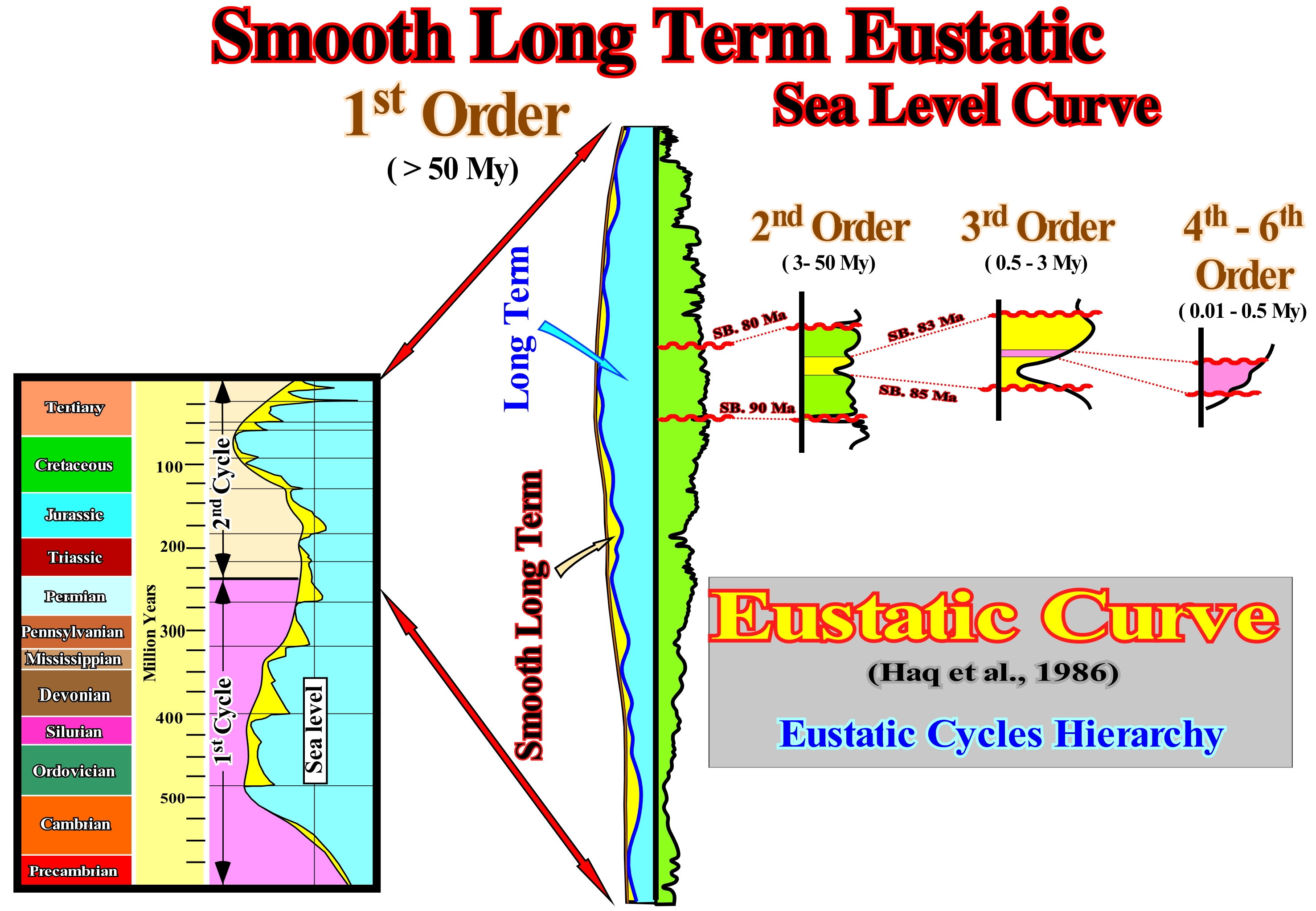
Taking into account that sea level may be: (i) Absolute or Eustatic and (ii) Relative. The absolute (eustatic) sea level is supposed to be global and referenced to the Earth's centre. The relative sea level is local and referenced to any point on the Earth's surface, which can be the base of the sediments or the sea floor. A rapid sea floor spreading induces a large volume of oceanic mountains and therefore the sea level rises invading the continents, since the Earth's formation (more or less, 4.5 Ga) the total volume of water is constant. Such marine ingression allows the deposition of sedimentary transgressions, which correspond to a set of increasingly important marine ingressions and increasingly smaller sedimentary regressions. On the contrary, a slow sea floor spreading (oceanic expansion) induces a marine regression (lowering of the sea). The shorelines are moved seaward. The seas withdraw from the continents and are restricted to the oceanic basins and areas of rapid tectonic subsidence. During the Phanerozoic, the amplitude of absolute sea level changes appeared to have been about 300 meters with a sea floor spreading rate of 2 to 6 centimeters per year (approximately the rate of growth of our nails). The sea level varies greatly in time and space. Sea level is not fixed and it is not a horizontal surface. There are sea level changes, between different points, of several meters and global variations between different moments of the geological history. At present, for instance, there is a sea level difference of about 40 meters between Nova Scotia and Florida. Between the Maldives and Papua New Guinea the sea level difference is higher than 200 meters. A boat sailing between these two areas, along an equipotential surface of gravity, would not consume energy. The sea level is affected by tides, wind, atmospheric pressure, local gravity differences, temperature, salinity, subsidence, etc. To determine the "middle sea level", the best thing to do is to choose a place and calculate the middle sea level at that point and use it as a reference point. Generally, the calculations for this measurement point are based on hourly observations made over a period of 30 years*. In sequential stratigraphy, sea level variations must always be referenced to one point. Geoscientists speak of relative sea level and absolute or eustatic sea level. The relative sea level is the result of the combination of absolute (eustatic) sea level and the effects of tectonics (subsidence of the sea floor, when the predominant tectonic regime is extensional or uplift, when the predominant tectonic regime is in compressional). The eustatic curve illustrated in this figure is the curve that Haq proposed for the Phanerozoic in 1986. This curve consists of eustatic cycles of several orders defined on the basis of the time-duration of each cycle. A 6th order eustatic cycle lasts between 0.01 and 0.03 My. A set of 6th order cycles forms a 5th order cycle whose duration ranges from 0.03 to 0.08 M. A set of 5th order cycles forms a 4th order cycle whose duration varies between 0.08 and 0.5 My. A set of 4th order cycles forms a 3rd order eustatic cycle, whose duration varies from 0.5 to 3-5 My (in this example, the 3rd order eustatic cycle is limited between the unconformities, SB. 83 Ma and SB. 85 Ma. A set of 3rd order eustatic cycles forms a 2nd order eustatic cycle, whose duration varies between 3-5 and 50 My (SB 80 Ma and SB 90 Ma, in this example. A set of 2nd order eustatic cycles forms a 1st order eustatic cycle, whose time-duration ranges from 50 to 400 My (SB 0 and SB ± 230 Ma, in this example). An eustatic cycle of a given order corresponds to the flattening of several lower-order eustatic cycles. The stratigraphic cycles deposited in association with first-order eustatic cycles are continental encroachment cycles (post-Rodhinia or post-Pangea to Phanerozoic). The eustatic cycles deposited in association with 2nd order eustatic cycles are continental encroachment sub-cycles. The stratigraphic cycles deposited in association with 3rd order eustatic cycles are the sequence-cycles. The stratigraphic cycles deposited in association with 4th, 5th and 6th order eustatic cycles are called high frequency cycles. In association with the eustatic paracycles, which form the eustatic cycles, but between them there is any relative sea level fall, sequence-paracycles are deposited, particularly, the sedimentary systems tracts subgroups forming a sequence-cycle.
(*) An average whether it is sea level or temperature, to have meaning it must cover a rather long period. The World Meteorological Organization (WMO) recommends that it covers 30 years: from there one can speak of « normal ».
Eustatic Change............................................................................................................................................................Changement Eustatique
Mudança eustática / Cambio eustatico / Eustatischer Wandel / 海平面变化 / эвстатические Изменить / Cambiamento Eustatico/
Global change of the mean sea level (between high and low tide) during a specific period of geological time. The main factors of an eustatic change (absolute or eustatic sea level change) are oceanic expansion and oceanic consumption along the subduction zones, i.e., changes in the volume of ocean basins. These variations can be evaluated from the curve of coastal onlaps and paleontological studies. Variations in the volume of ocean water during glaciations and melting times (eustatism glacial) also produce eustatic changes.
See: « Eustasy »
&
« Relative Sea Level Change »
&
" Accommodation "
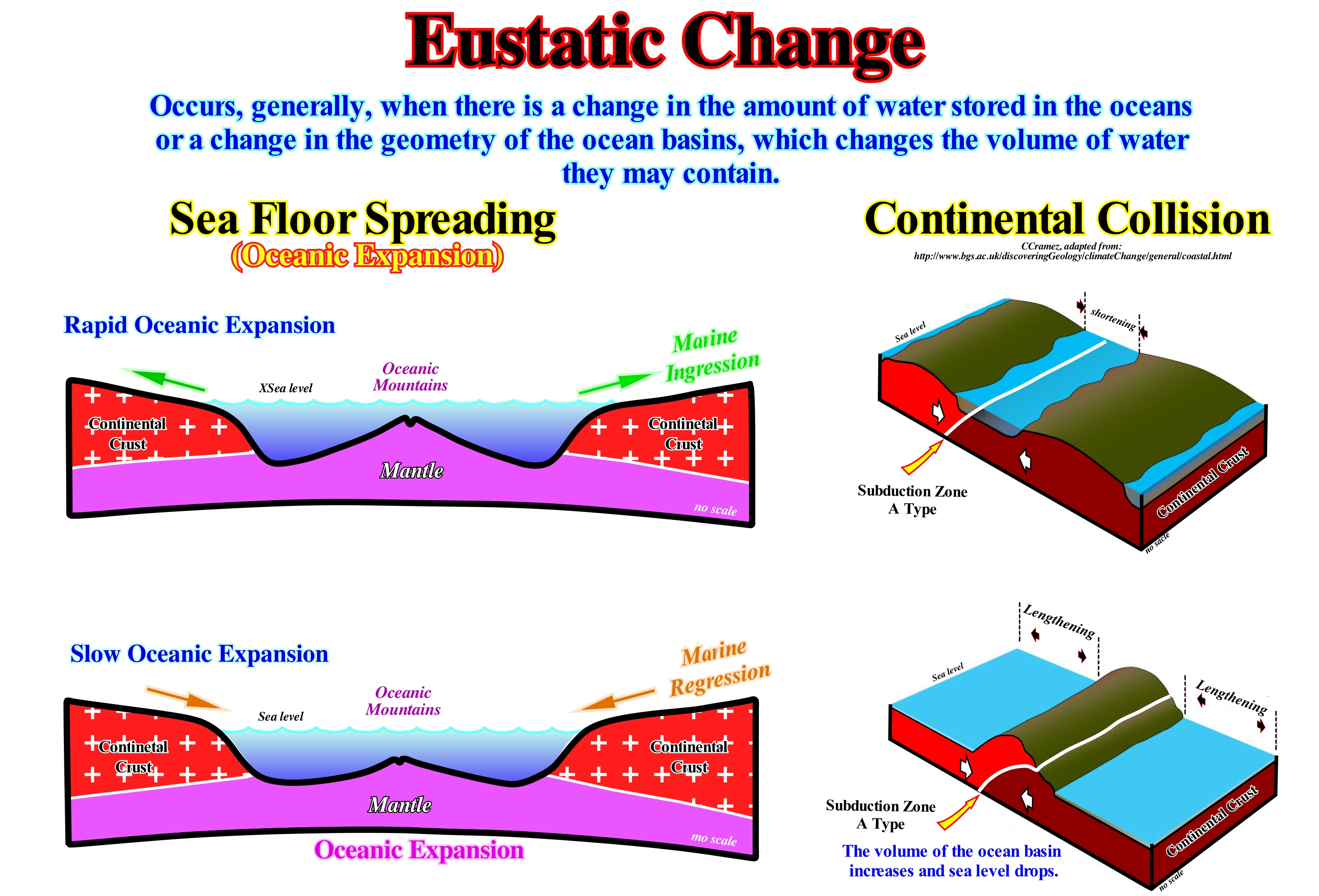
Assuming : (i) Since the Earth's formation (about 4,5 G years ago) the amount of water, in all its forms, is constant and the volume of the ocean basins varies throughout the geological history, eustatic changes (absolute or eustatic sea level changes, i.e., change of the sea level referenced to the Earth's centre, which area supposed to be global) are mainly, dependent, on tectono-eustasy (volume variations of the oceanic basins induced by sea floor spreading). However: a) Glacio-Eustasy (variations in the volume of water the oceans induced by glaciations and melting epochs) ; b) Geoidal-Eustasy (variations in the distribution of ocean water caused by changes in the Earth's field of gravity) and c) Thermal expansion of the oceans (steric* sea-level rise), play a non negligible role. The volume of ocean basins is, relatively, small when the continents coalesce to form a supercontinent. The vast majority of oceanic mountains have been consumed along the B-type subduction zones. When the continents are separated from each other, among them there are many oceanic ridges (oceanic mountains) and the volume of the ocean basins is smaller. In the first case, the level of the eustatic or absolute sea is low, while in the second it is higher. Similarly, when sea floor spreading (oceanic expansion) is rapid, the morphology of the oceanic ridges is quite important, which lowers the volume of the ocean basins. The sea floor spreading velocity is on average 1 cm per year, which corresponds, roughly, the growth rate of the nails of a human being. When sea floor spreading is slow, the volume of the ocean basins is larger. The morphology of the oceanic ridges is less marked, since the volcanic material has time to cool down and become denser. As illustrated in the sketches of this figure, it can be said when oceanic expansion is rapid, it produces a large volume of oceanic ridges and sea level rises invading the continents, producing what, normally, is called a marine ingression or a marine transgression, which is the same thing. When the oceanic expansion is slower, the eustatic or global sea level falls inducing a sedimentary marine regression. The shoreline and associated coastal deposits are displaced seaward. These global marine ingressions and regressions, associated with absolute (eustatic) sea level rises and falls should not be confused, with local ingression and regressions, such as those found within sequence-cycles. In a sequence-cycle (stratigraphic cycle induced by a 3rd order eustatic cycle, which has a time-duration between 0.5 and 3-5 My), a marine ingression induces an eustatic paracycle i.e., a rise of the relative sea level (sea level, local, resulting from the combined action of absolute sea level and tectonics and referred to the base of sediment or to the sea floor). Marine ingressions may be in acceleration, i.e., increasingly important or in deceleration (increasingly smaller). The sediments (sequence-paracycles) are deposited during the stability period of relative sea level occurring after each marine ingressions. To have deposition, updip of the continental edge, the space available for the sediments (shelfal accommodation) must, always, increase. When within a sequence-cycle, the relative sea level rises in acceleration, the sequence-paracycles are deposited with a retrogradational geometry (transgressive interval). When the relative sea level rise in deceleration, the sequence-paracycles have a progradational geometry. In other words, in transgressions (set of increasingly important marine ingressions and sedimentary regressions increasingly smaller), the sequence-paracycles are, globally, thinning upward. In a regression (set of increasingly smaller marine ingressions and sedimentary regressions increasingly important), the sequence-paracycles are coarsening upward. Summing up, within a sequence-cycle, in order to have sedimentary transgressions or regressions, the relative sea level must always increase. When it increases in acceleration, transgressions are deposited which, globally, have a retrogradational geometry. When the relative sea level rises in deceleration, regressions are deposited which, globally, have a well-defined progradational geometry.
(*) The steric sea level rise is a function of the spatial arrangement of atoms. If the temperature of the oceans increases, the density of the water decreases and, for a constant mass, the volume increases.
Eustatic Change in Sea Level...................................Changement eustatique du niveau de la mer
Mudança eustática do nível do mar / Cambio eustático del nivel del mar / Eustatische Veränderung des Meeresspiegels / 全球海平面变化 / Эвстатические изменения уровня моря / Variazioni eustatiche del livello del mare /
Redundant expression, since eustatic implies sea level. Global change of sea level referenced to the Earth's center. The main factors are: (i) Temperature ; (ii) Salinity ; (iii) Amount of water in the form of snow or ice ; (iv) Volume of ocean basins, etc.
See: « Eustasy »
&
« Relative Sea Level Change »
&
" Accommodation "
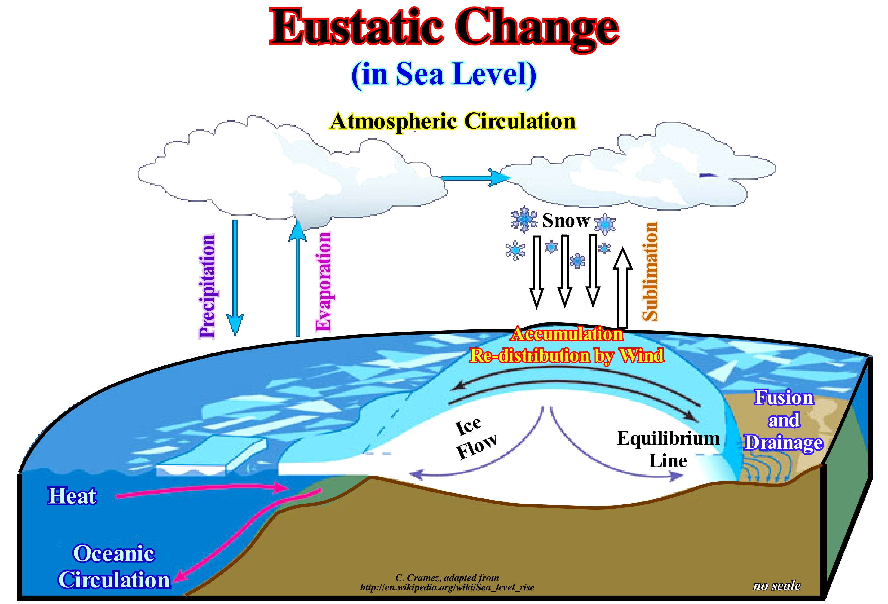
An eustatic change can be induced by: A) Tectono-Eustasy (variation of the sea level function of the volume of the oceanic basins that is conditioned by the sea floor spreading) ; B) Glacio-Eustasy (variations of the volume of water the oceans induced by glaciations and periods of melting) ; C) Geoidal-eustasy (variations in the distribution of ocean water caused by variations in the terrestrial gravity field) and D) Thermal Expansion of the oceans or Steric sea level rise. Only glacial changes are both important (> 10 m) and fast (<1 m). Sea level changes can be determined in relation to the sea floor or in relation to the Earth's centre. The former are relative. They are a function of the latter, but also of the movements of the sea floor. If the absolute (eustatic) sea level does not vary and the sea floor falls (subsidence), relative sea level rises. On the contrary, if the sea floor rises, the relative sea level falls. Changes in relative sea level are, generally, local or regional, but not global. Absolute (eustatic) sea level changes are global variations. In the sequential stratigraphy, geoscientists always consider two types of sea level: (i) Absolute or eustatic sea level, which is the the sea global referenced to the Earth's centre, and (ii) Relative sea level, which is the sea level local referenced to the base of the sediments (top of continental crust) or the sea floor. Relative sea level results of the combined action of absolute or eustatic sea level and tectonics (subsidence or uplift of the sea floor). An eustatic sea level change is an absolute (eustatic) sea level change and not a relative sea level change. The concept of eustatic change makes, only, sense if: (i) The amount of water in all its forms is constant from the beginning of the Earth's formation and (ii) The volume of the ocean basins varies throughout the geological history. To date, the first conjecture has not yet been refuted. The vast majority of observations corroborate it. The second conjecture is corroborated by the Plate Tectonics paradigm. In periods when all continents are agglutinated against each other and the number of lithosphere plates is small, the volume of the ocean basins is very large (most oceanic mountains disappeared along the B-type subduction zones). As a result the level of the eustatic sea falls. On the contrary, when, after a break-up of a supercontinent, when the continents are at their maximum dispersion, the volume of the ocean basins is very small. There are large numbers of oceanic mountains, i.e., oceanic ridges and, therefore, the level of the eustatic sea rises. So does the amount of ice, as illustrated in this figure. During the glaciations, the eustatic sea level falls. On the contrary, during the thaw (deglaciations of certain geoscientists) the eustatic sea level rises. Everyone knows the eustatic level rose about 120 meters during the millennia that followed the end of the last glacial age (more or less, 21 ka) and it has stabilized between 3 and 2 ka. However, a particular attention has to be given to ice caps or ice sheets (ice masses covering respectively less than or greater than 50,000 km2 of a continent) and ice shelves or ice seas (thick, but floating, ice that has been discharged, as illustrated in this figure, or formed directly on the surface of the sea). The melting of the former implies a rise in sea level, while the melting of the latter does not. The sea level falls. The ice is less dense than the water. The maximum extent of the ice caps and ice-seas (Northern and Southern hemispheres) during the last ice age was reached, approximately, at about the same time and more or less there are 19 ka.
(*) If the temperature of the oceans increases, the density of water decreases and, for a constant mass, the volume increases, is what the geoscientists call thermal expansion of the oceans or steric sea rise (function of the spacial arrangement of atoms). The whole problem is to know whether it is the increase of CO2 in the atmosphere that increases the temperature of the oceans or if it is the increase in the temperature of the oceans that releases CO2 into the atmosphere. The ability of water to maintain a certain amount of dissolvedCO2 is a function of its temperature. The lower the water temperature the more dissolved CO2 it supports. At high latitudes, the surface water is icy and allows the dissolution of high concentrations of atmospheric CO2. When the surface of the sea freezes, the salt is kept out of the freezing process and dissolves in the water, immediately, under the sea of ice. Ice-cold and salty and with much dissolved atmospheric CO2, the water becomes more dense, sinks and flows along the continental slope of the polar platforms, invading the deeper regions of the ocean basins.
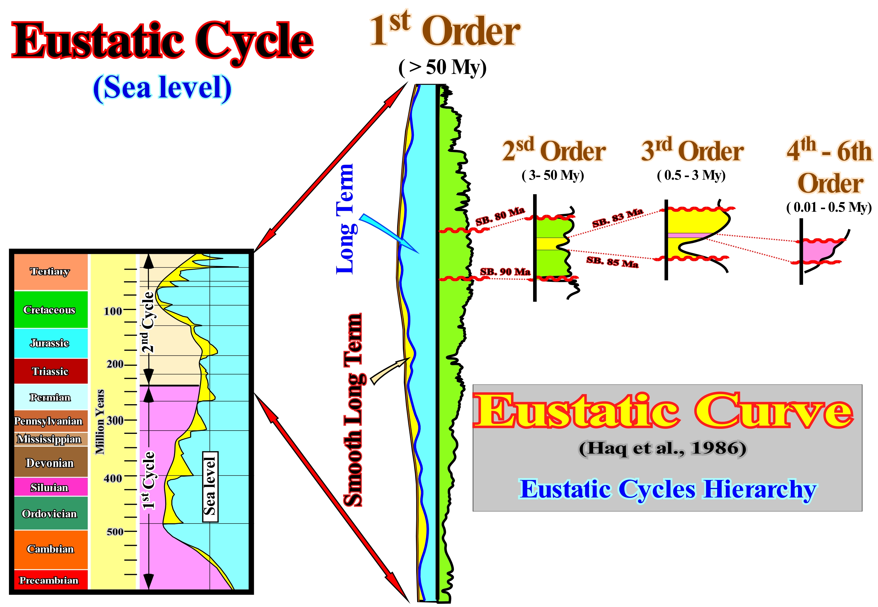
Eustatic Cycle...............................................................................................................................................................................................Cycle eustatique
Ciclo eustático / Ciclo eustático / Eustatische Zyklus / 海平面周期 / Эвстатический цикл / Ciclo eustatiche, Ciclo eustatico /
The length of time during which a rise and fall of the mean sea level is observed on a global scale. There are six orders of eustatic cycles: (i) First order cycles ; (ii) Second order cycles ; (iii) Third order cycles and (iv) Fourth order cycles ; (v) Fifth order cycles and 6th order. In the Phanerozoic, i.e., after the Precambrian, there are two eustatic cycles of 1st order (break-up of the supercontinents) with durations of 250 and 350 My (> 50 Ma). The 2nd order cycles have durations between 3-5 and 50 My. For 3rd order cycles, the durations range from 0.5 to 3-5 My. The 4th, 5th and 6th order cycles have durations ranging from 0.01 to 0.5 My.
See: « Eustasy »
&
« Relative Sea Level Change »
&
" Sequence Stratigraphy (sequential) "
As illustrated, in this scheme of the eustatic curve proposed by Exxon (1977), we can recognize, at least, six hierarchical orders, defined by different eustatic cycles, which are characterized by different time-durations : (i) First order eustatic cycles have a time longer than 50 My ; (ii) Second order eustatic cycles have a duration between 3-5 and 50 My ; (iii) Third order eustatic cycles have a time-duration between 0.5 and 3-5 My and (iv) The 4th, 5th and 6th order eustatic cycles have a duration between 0.1 and 0.5 My. The Phanerozoic Eon is formed by two 1st order eustatic cycles. The first cycle induced what the geoscientists call the Paleozoic, i.e., the geological era between about 542 and 245 million years ago, which follows the Neoproterozoic of the Proterozoic Era and precedes the Mesozoic Era. The second 1st order eustatic cycle of the Phanerozoic induced the deposit of what is, commonly, called Mesozoic-Cenozoic. These eustatic cycles are associated with the volume changes of the ocean basins during the aggregation and dispersion of the continents forming the Protopangea and Pangea supercontinents. Assuming the volume of water, in all its forms, has been constant since the Earth formation (± 4.5 billion years ago), when a supercontinent break-up, the sea floor spreading (oceanic expansion) begins with formation of important submarine mountains (oceanic ridges), which diminishes, significantly, the volume of the ocean basins. Such a decreasing forces the absolute (eustatic) sea level (supposed global and referenced to the Earth's centre) to rise flooding the distal parts of the continents. On the contrary, since the rate of absorption of the old oceanic crust along subduction zones is not compensated by the formation rate of new oceanic crust, the volume of the ocean basins increases, causing a significant fall of the absolute (eustatic) sea level. Such a fall of the absolute sea level displaces the shoreline seaward and downward exhuming the continental platform (if the basin had a shelf) and the upper part of the continental slope. The 2nd order eustatic cycles are, mainly, associated with changes in the velocity of tectonic subsidence* during evolution of the continents. The tectonic subsidence is given by the sediment thickness plus water-depth minus the isostatic compensation effect (induced by sedimentary overload) and increased by compaction effect. The 3rd order eustatic cycles are, probably, induced by glacio-eustasy (absolute sea level changes due to the storage or release of ice-water from glaciers and glacial ice caps). The high frequency eustatic cycles (4th, 5th and 6th orders) are associated with the climatic changes created by the Milankovitch orbital cycles. The periodicities of the Milankovitch's cycles are: a) 100 ky, between 0 and 800 ka ; b) 800 k, between 0.8 Ma and 6.3 Ma ; c) 1.6 My, between 6.3 Ma and 150.5 Ma ; d) 4.0 My, between 150.5 Ma and 177.0 Ma ; e) 1.6 M, between 177.0 Ma and 188.5 Ma ; (f) 4.0 My, between 188.5 Ma and 237.0 Ma and g) 1.6 My, between 237.0 Ma and the base of Permian. It is, also, important to consider the eustatic paracycles, which compose the eustatic cycles. An eustatic paracycle, as its name suggests (from the Greek "para" meaning "about") corresponds to a relative sea level** rise which is followed by a stability period of relative sea level, before another rise occurs. There is any relative sea level fall between successive eustatic paracycles, otherwise it was the limit between two sequence-paracycles. Each of the different eustatic cycles is associated with a certain type of stratigraphic cycles. For instance, a 3rd order eustatic cycle induces a sequence-cycle, which is composed by two groups of sedimentary systems tracts: (i) Highstand Systems Tracts Group (HSTG), within which two sub-groups of sedimentary systems tracts can be distinguished: 1- Transgressive Interval (TI), at the base and 2- Highstand Prograding Wedge (HPW), at the top ; (ii) Lowstand Systems Tracts Group (LSTG), in which, the from the bottom to top, the following systems tracts sub-groups can be differentiated: a) Submarine Basin Floor Fans (SBFF) ; b) Submarine Slope Fans (SSF) and (iii) Lowstand Prograding Wedge (LPW). Within each sub-group of sedimentary systems tracts, the deposition, i.e., the sequence-paracycles, occur during the period stability of relative sea level that separates the marine ingressions. This means whichever the paracycle is considered, the completeness (ratio of actual deposition time to total geological time) is always less than 1.
(*) In the broad sense, the tectonic subsidence is the sinking of the earth crust in relation to the geoid. The movement of lithospheric plates and the accommodation created by the faults develop at large scale subsidence in all types of sedimentary basins (divergent margins, backarc basins, foreland basins, etc.). Three mechanisms are common in the subsiding areas: (i) Lengthening ; (ii) Cooling and (iii) Charging (loading).
(**) Sea level, local, referenced to any point of the Earth's surface, which can be the seafloor or the base of sediments (top of the continental crust) and which is the result of the combined action of absolute (eustatic) sea level and tectonics.
Eustatic Megacycle......................................................................................................................................................Mégacycle eustatique
Megaciclo eustático / Megaciclo eustático / Megacycle eustatischen / 兆周海平面 / Эвстатический мегацикл / Megaciclo eustatico /
The term eustatic mega-cycle, in this glossary, is replaced by a first-order eustatic cycle, since it does not correspond in any way to a large or enormous eustatic cycle as the prefix "mega" suggests. A first order eustatic cycle is formed by a number of second order eustatic cycles. A first-order eustatic cycle lasts over 50 My (millions of years), usually, around 240 My. First-order eustatic cycles (former mega-cycles) are induced by sea level changes associated with the break-up and aggregation of supercontinents (Pangea, Rodhinia or Protopangea, etc.).
See: « Eustatic Cycle »
&
« Stratigraphic Cycle »
&
« Eustasy »
First order eustatic cycles are related to tectonic plate activity. The Paleozoic eustatic high (absolute sea level* was about 200-250 meters higher than at present-time, occurred at about 500 Ma, when the dispersion of the Paleozoic continents was maximal) derived from the break-up of the Rodhinia supercontinent*. This sea level high corresponds to a high of the absolute (eustatic) sea level, i.e., of the global sea level, referenced to the Earth's centre, which is, mainly, controlled by tectono-eustasy**, glacio-eustasy, geoidal-eustasy and thermal dilation thermal or steric *** sea level rise. About 91.5 Ma, the Mesozoic-Cenozoic eustatic high emphasizes the maximum dispersion of the continents derived from the break-up of the Pangea supercontinent. These absolute sea level changes were induced by changes in the volume of ocean basins induced by changes in the volume of oceanic mountains associated with oceanic ridges and sea floor spreading (oceanic expansion). The amount of water in all its forms, solid and gaseous liquid, is assumed to be constant since the Earth formation (± 4.5 Ga). Such a conjecture was not refuted until today. So, if the volume of the ocean basins increases due to subduction of the oceanic crust and oceanic ridges along the Benioff subduction zones, the absolute (eustatic) sea level falls. An important marine regression accompanied by a significant sedimentary regression (displacement of coastal deposits seaward and upward) occurs. Otherwise, if the volume of the oceanic basins decreases (formation of new oceanic crust and oceanic ridges), the absolute sea level, globally, rises causing a great marine ingression. A serie of sedimentary regressions, increasingly smaller, takes place. This is very important, because throughout the geological history, the volume of the ocean basins varied several times. At the time of a supercontinent formation, all or almost all the continental crust is clumped in a small number of lithosphere plates. The volume of the ocean basins is very large. The oceanic mountains (ocean ridges), if present, are little developed. Over time, the vast majority of them disappear, not only because the oceanic crust becomes cooler and denser (less bulky) but, also, because a large part has been consumed along the B-type (or Benioff-type) subduction zones. With the break-up of the supercontinent, the individualized continents disperse due to oceanic expansion (sea floor spreading). The volume of the ocean basins decreases until the maximum of dispersion. The oceanic mountains, i.e., the oceanic ridges become, more and more, numerous and higher. This figure shows the two Phanerozoic eustatic mega-cycles (presently called 1st order eustatic cycles). The oldest is the 1st order eustatic cycle that induced the deposition of the Paleozoic sediments. It is associated with the break-up of the Proto-Pangea supercontinent (or Rodhinia) and with the evolution of the continents that it individualized. The second eustatic mega-cycle corresponds to the 1st order eustatic cycle associated with the break-up of the Pangea supercontinent. It induced the deposition of the Mesozoic/Cenozoic sediments. Within each of these cycles there is two phases: (i) Transgressive Phase and (ii) Regressive Phase. The transgressive phase developed during the absolute (eustatic) sea level rise, which encroaches the continents. The regressive phase developed during the absolute sea level fall, exhumed a significant part of the continents. First-order eustatic cycles (eustatic mega-cycles) induce the deposition of continental encroachment stratigraphic cycles, within a retrogradational transgressive phase and a progradational regressive phase can easily be recognized.
(*) Rodhinia supercontinent (from Russian "rodit"= growth was formed around 1.1 Ga as a result of the Grenville orogeny. The Rodhinia central part , on the equator, was occupied by Laurentia (North America and Greenland), surrounding Amazonia flanked by West Africa, Baltica, Siberia and the Indian craton Indian associated with four Australian cratons and the Chinese craton. After the Rodhinia break-up, between 600 and 560 Ma was reconstituted the Pannotia supercontinent Pannotia which, later, burst (around 540) to form Laurentia and Siberia, then Baltica at the very end of the Proterozoic opening the Iapetus Sea.
(**) Tectono-Eustasy is controlled by volume changes in the ocean basins, while glacio-eustasy is controlled by changes in the volume of water in the oceans induced by glaciations and melting seasons. Geoidal-eustasy is controlled by the distribution of ocean water caused by variations in the terrestrial gravity field. The thermal expansion of the oceans or steric sea level rise is induced by a significant temperature increasing of the water (if the temperature of the oceans increases, the density of the water decreases and, for a constant mass, the volume increases).
(***) Thermal expansion is the main factor of steric sea level changes. Salinity is a minor factor. A steric increase of the sea level is a measure of the total content of heat of the oceans.
Eustatic Paracycle...........................................................................................................................................................Paracycle eustatique
Paraciclo eustático / Paraciclo eustático / Paracycle eustatischen / 全球海平面准周期 / Эвстатический парацикл / Paraciclo eustatico /
Time interval occupied by rise and stabilization of relative sea level (regional scale), followed by another relative rise without any significant relative sea level fall occurring. Eustatic paracycles are, probably, induced by the Milankovitch orbital cycles, which control the solar energy received by the Earth's surface. Climatic variations induce changes in the amount of water in the ocean basins. Milankovitch's orbital cycles have durations of 19 k, 23 k, 41 k, and 100 k years.
See: « Milankovitch's Cycle »
&
« Eustatic Cycle »
&
« Stratigraphic Cycle »
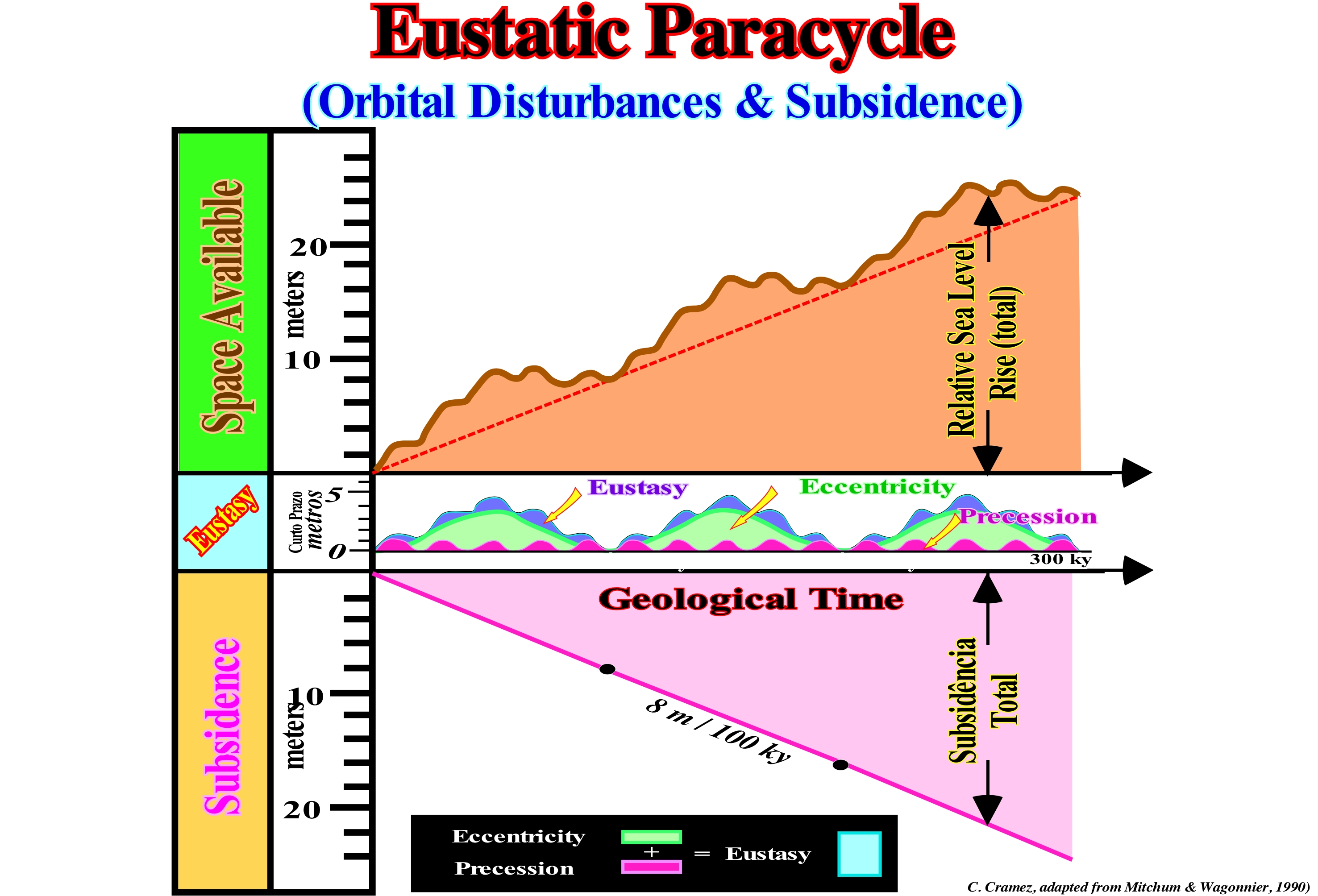
The definition of a flooding surface (sequence-paracycle boundary) is independent of the its formation mode. It can be produced either by: (i) An eustatic rise (change in absolute or eustatic sea level, which is supposed to be global and referenced to the Earth's centre) ; (ii) A relative sea level rise (local sea level, referenced to the base of the sediments, sea floor or to any other point on the land surface, which is the result of the combined action of absolute sea level and tectonics) ; (iii) A fault ; (iv) A deepening of the water resulting from the subsidence by compaction of a deltaic lobe or (v) A lateral displacement of deltaic depocenter (pendulum effect). An eustatic paracycle or the associated sequence-paracycle can be created by autocyclic or allocyclic mechanisms. The firsts are mechanisms occurring, only within the sedimentary basin, such as tides, storms, etc. The allocyclic mechanisms occur outside the sedimentary basin, such as sea level changes, climate, tectonics, etc. Considering just the influence of the precession* of the axis of rotation of the Earth and the eccentricity of the orbit (deviation from a circular shape orbit) it can be said the absolute (eustatic) sea level rises represent eustatic paracycles. Practically, there are no relative sea level falls between each increment, as can be seen in this figure. When eustatic changes, induced by eccentricity and precession, are combined with basin subsidence, it is evident eustasy plays the leading role in the cyclicity of variations in available space for the sediments (accommodation). In other words, it is the eustasy, i.e., the absolute sea level changes that produce the cyclicity of the sedimentary deposits. This conjecture is difficult to refute, even in the sedimentary basins associated with compressional tectonic regimes (foreland basins and mountain ranges). The absolute (eustatic) sea level is a function of: (i) Tectono-Eustasy (controlled by the volume variation of the ocean basins) ; (ii) Glacio-Eustasy (controlled by the variation of ocean water volume, mainly associated with the amount of ice) ; (iii) Geoidal-eustasy (controlled by the distribution of ocean water caused by variations in the terrestrial gravity field) and (iv) Thermal expansion of the oceans or steric sea level rise** (if the temperature of the oceans increases, the density of the water decreases and, for a constant mass, the volume increases). Certain geoscientists think in the sedimentary basins associated to the formation of the megasutures, tectonics can, in certain cases, be the main responsible of the cyclicity of the sedimentary deposits. Do not forget within a sequence-cycle (induced by a 3rd order eustatic cycle, whose time-duration varies between 0.5 and 3.5 My), between each eustatic paracycle (increasing of the available space for the sediments) there is a stability period of the relative sea level during which sediments are deposited. Everything seems to happen in the following way: (i) A marine Ingression (relative sea level rise or eustatic paracycle) produces a continentward displacement of the shoreline creating a ravinment surface in the sea floor ; (ii) Stability period of relative sea level, during which the shoreline moves seaward (progradation), as the sedimentary particles deposit by sigmoid progradations ; (iii) Progradation of the shoreline may or may not exceed the position it had before the relative sea level rise (in the first case there is a sedimentary regression, in the second there is a sedimentary retrogradation) ; (iv) Relative sea level rise, which may be more important than the preceding (relative sea level rise in acceleration) or less (relative sea level rise in deceleration) and so on until a significant relative sea level fall take place, changing the highstand geological conditions to lowstand with development of an unconformity.
(*) A gyroscopic change of the axis of rotation which does not align with the axis of the ecliptic, but precesses around it, in the same way as a spinning top when precessing about the axis vertical to the ground.
(**) The steric effect comes from the fact that each atom contained in a water molecule occupies a certain space. An increase in water temperature increases the size of atoms. In fact, Pauli or Bohr repulsion implies that a certain amount of energy is required to overlap the clouds of the electronic orbital lobes so that the atoms are brought closer to each other. An expense or an energy gain affects the normal form of the molecule and its properties.
Eustatic Sea Level (Global sea level)....................................................................................Niveau de la mer eustatique
Nível do mar eustático / Nivel del mar eustatico / Eustatische Meeresspiegel / 相对海平面 / Эвстатических уровня моря / Eustatici livello del mare /
Sea level referenced to a global fixed point, which is, generallyl the center of the Earth. The eustatic sea level rises or falls as a function of the volume of ocean basins and the volume of ice sheets and glaciers (glaciers included), since the volume of water under all its forms (solid, liquid and gaseous) is considered constant since the Earth's formation (± 4.5 Ga = 4.5 x 10⁹ or 4.5 billions of years ago). Synonym of Absolute Sea Level.
See: « Sediment Influx »
Eustatic Sea Level Change (Absolute sea level)......................Changement Eustatique du niveau de la mer
Variação do nível do mar absoluto/ Variación absoluta (del nivel del mar) / Eustatischer Meeresspiegelwechsel / 海平面变化 / Изменение уровня эвстатического моря / Cambiamento di livello del mare Eustatico /
Absolute sea level change, which is the sea level, supposed to be global and referenced to the Earth's center and which depends on: (i) Tectonico-Eustasy; (ii) Glacio-eustasy ; (iii) Geoidal-Eustasy and (iv) Steric rise in sea level or thermal expansion of the oceans.
See: « Relative Sea Level Change »
Eustatic Sea Level Curve..........................................................................................................................................................Courbe eustatique
Curva eustática / Curva eustática / Eustatische Meeresspiegel-Kurve / 海平面升降曲线 / Эвстатические кривая уровня моря / Curva di livello eustatiche del mare, Curve delle oscillazioni eustatiche del livello marino /
Curve of absolute (eustatic) sea level changes, generally, measured in relation to the Earth's centre via a radar satellite. Theoretically, the eustatic curve is considered global. To have a certain value, the eustatic curve must take into account the gravity anomalies. The sea level is wavy. It is higher where gravity anomalies are negative (less attraction) and lower where gravity anomalies are positive (great attraction). The mean sea level is an equipotential surface, which corresponds, more or less, to the geoid.
See: « Eustatic Cycle »
&
« Stratigraphic Cycle »
&
« Eustasy »
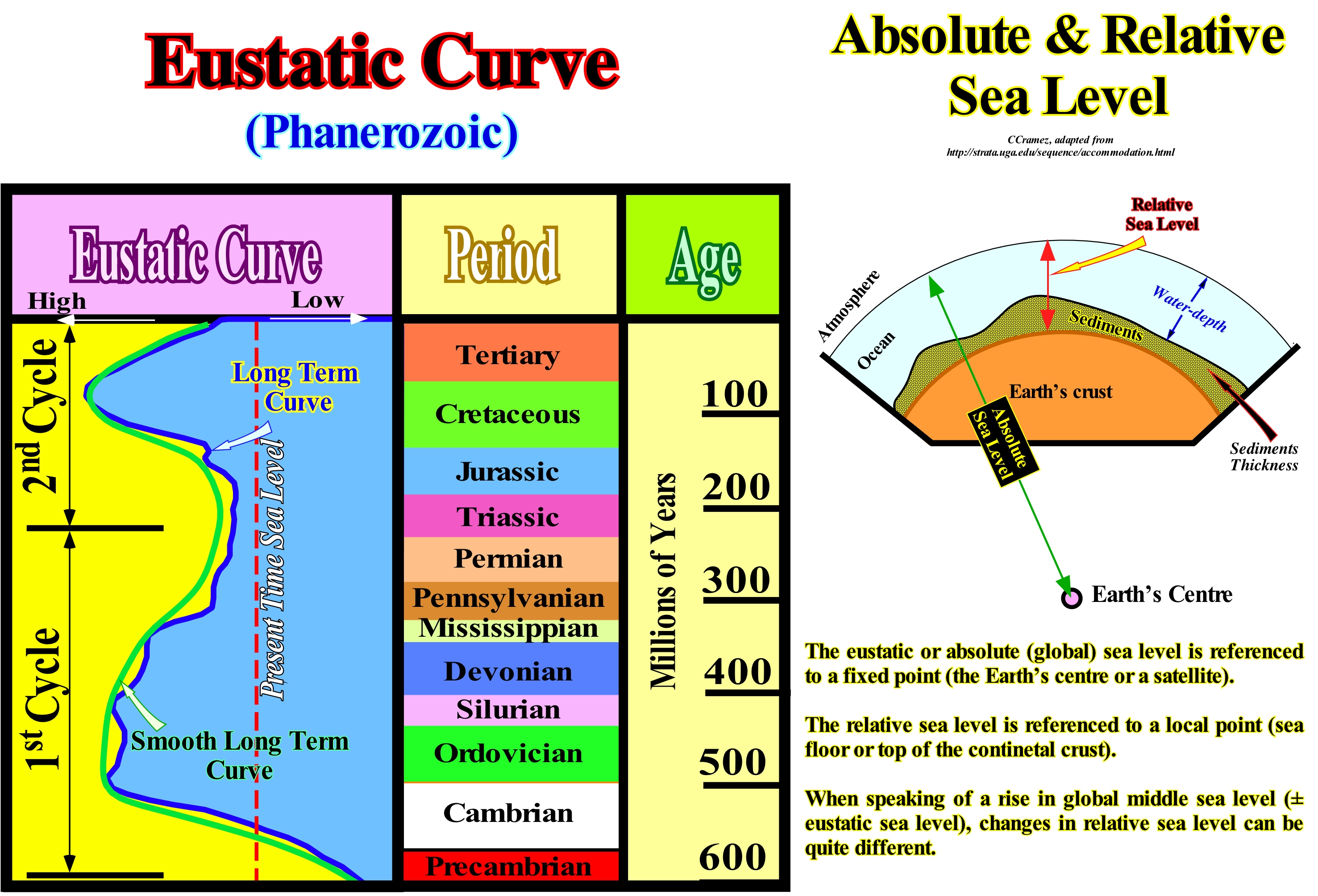
As illustrated in the geological sketch of this figure, the sea level may be: (i) Absolute or Eustatic, i.e., the supposed global sea level referenced to the Earth's centre and (ii) Relative, which is a local sea level referenced to any point on the Earth's surface, which may be, for instance, the base of the sediments (top of the continental crust) or the sea floor. The relative sea level is the result of the combined action of absolute (eustatic) sea level and tectonics (subsidence of the sea floor, when the predominant tectonic regime is in extensional or uplift, when the predominant tectonic regime is in compressional). Assuming the volume of water, in all its forms, is constant since the Earth's formation (± 4.5 Ga), it can be said sea level changes in relation top the present-time sea level (see diagram eustatic curve), have resulted and will probably result from the following factors: (i) Form and volume of ocean basins ; (ii) Redistribution of water within ocean basins and (iii) Vertical movement of coastal zones. The absolute (eustatic) sea level is dependent on: (i) Tectono-Eustasy, which is controlled by the volume variation of the ocean basins ; (ii) Glacio-Eustasy, which is controlled by the variation of ocean water volume as a function of the amount of ice ; (iii) Geoidal-Eustasy, which is controlled by the distribution of ocean water caused by variations in the terrestrial gravity field, and (iv) Thermal expansion of the oceans or Steric sea level rise (if the temperature of the oceans increases, the density of the water decreases and, for a constant mass, the volume increases). Sea level variations, controlled by Earth's internal geological mechanisms and by the growth or melting of glacial ice caps, have characteristic amplitudes and durations. The dynamic mechanisms of the mantle alter the shapes of the ocean basins, more or less, all the 100 My. The tectonic mechanisms, which occur in the crusty lithosphere, produce differential movements between land and sea, at very varied time scales. The influence of these processes is limited (± hundreds of kilometers). Sea level variations caused by glacial cycles are global, with a time scale between 1 and 100 ky. The eustatic cycles, i.e., the cycles of sea level changes, have a temporal hierarchy (duration of cycles). In this figure, the eustatic curve from the break-up of the Proto-Pangea (Rodhinia) supercontinent to today is represented in its long term (blue) and smooth long term (green) form. The drift and agglutination of the continents, individualized by the break-up of the Rodhinia and later by the break-up of the Pangea supercontinent, suggest sea level changes were, mainly, induced by the shapes and volumes of the ocean basins and not by climate changes as is, probably, the case for eustatic cycles of 2nd and 3rd order or higher order. The second eustatic curve (hierarchy 2, i.e., long duration curve), coloured in blue, is very undulating and, as can be seen, it is composed of second order eustatic cycles having a duration between 3-5 and 50 My. The first, smoother and coloured in green represents, for the Phanerozoic, the eustatic curve of hierarchy 1 (smooth long term curve). It consists of two first-order eustatic cycles, that is to say, two cycles with a wave-length (time-duration) greater than 50 My. In association with the older cycle, the Paleozoic sediments were deposited. In association with the most recent cycle, the sediments forming the Mesozoic/Cenozoic were deposited. In the Paleozoic eustatic cycle (1st order cycle), the maximum of the absolute sea level is in the Cambrian and Silurian, during which the deposition of Paleozoic marine source-rocks is very likely. In association with the Mesozoic/Cenozoic eustatic cycle (1st order cycle), and particularly with the two eustatic peaks (Kimmeridgian and Cenomanian-Turonian), deposited the potential marine source-rocks of the post-Pangea continental encroachment stratigraphic cycle. The Paleozoic eustatic maximum, with sea level higher 200-250 meters than at present, occurred to about 500 Ma, when the dispersion of the Paleozoic continents was maximum. Likewise, the Meso-Cenozoic eustatic maximum (± 91.5 Ma) correlates with the maximum dispersion of the post-Pangea continents. Sea level was low during the Proto-Pangea and Pangea supercontinents. According to G.F. Ulmichek (1991), about 60% of the world's oil and gas reserves were generated by the Kimmeridgian and Cenomanian/Turonian source-rocks (around 25% for Oxfordian/Kimmeridgian marine clays, in association with DS. 138.5 Ma (downlap surface) while, more or less, 10% were generated by the Paleozoic marine source-rocks. That does not means Paleozoic source-rocks have a lower quality than Mesozoic/Cenozoic source-rocks. The great majority of the hydrocarbons generated during the Paleozoic have been lost due to Hercynian or Variscan orogeny that occurred between the Late Devonian ( ± 380 Ma) and Middle Permian (± 280 Ma).
Eustatic Stillstand (Relative sea level)..............................................................................................................Équilibre eustatique
Equilíbrio eustático (nível do mar relativo) / Equilibrio eustático / Balance eustatischen, Eustatische Stillstand / 平衡海平面 / Эвстатическое равновесие / Equilibrio eustatico /
Constant relationship between sea level and surface deposition. The relative sea level does not vary during deposition. Such a geological situation is, easily, recognized, in the field, as well as, on the seismic lines, by toplaps without vertical deposition (upbuilding ) or insignificant vertical accretion (below seismic resolution).
See : « Relative Sea Level Change »
&
« Coastal Onlap Curve »
&
« Onlap »
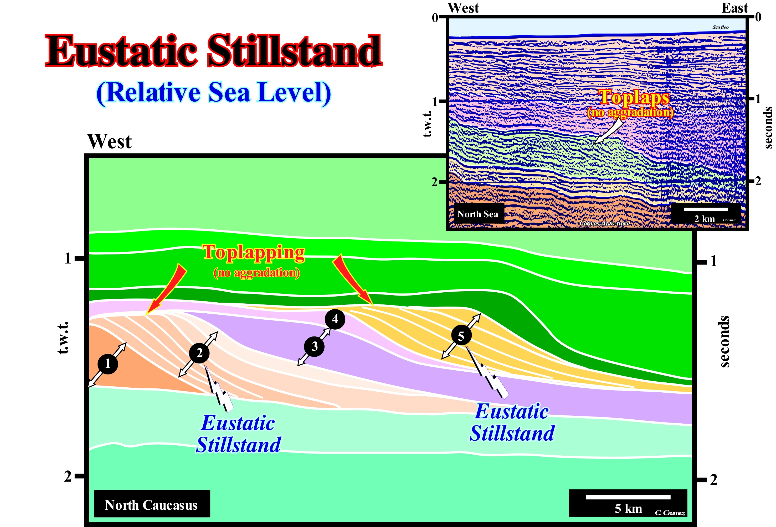
On this tentative geological interpretation of a Canvas auto-trace detail of a Caucasus seismic line, two progradational sedimentary intervals (interval 2 and interval 5) are characterized by an oblique internal configuration with toplaps without upbuilding (aggradation). The same is visible on the tentative geological interpretation of an auto-trace of detail of a North Sea seismic line shown in the upper right corner of this figure. This type of reflector termination (lapout), which is, often, difficult to differentiate from toplaps by erosion, suggests relative sea level stability* during the deposition of the associated sedimentary regression. This means that the shelfal accommodation (available space for sediment) remained, more or less, constant. As there is no increase in accommodation, i.e., increasing of available space for sediments (induced by a relative sea level rise, i.e., by a marine ingression), the sedimentary particles transported to the shoreline are deposit by simple lateral accretion. This lateral accretion moves the shoreline seaward without vertical displacement, neither up nor down. The geometry of the reflectors, within these two intervals, is characteristic of oblique progradation (no aggradation). There is no erosion or just a minimal erosion (lower than seismic resolution). A relative sea level stillstand is, obvious, with eustasy (absolute or eustatic sea level changes) and with tectonics (subsidence or uplift of the sea floor). The eustasy and tectonics effects are, just, equalized. The available space created by a subsidence is balanced by an equivalent absolute sea level fall or the available space lost by a tectonic uplift is set off by an equivalent absolute sea level rise. The absolute (eustatic) sea level is dependent on: (i) Tectono-Eustasy which is controlled by the volume variation of the ocean basins ; (ii) Glacio-Eustasy, which is controlled by the variation of ocean water volume as a function of the amount of ice ; (iii) Geoidal-Eustasy which is controlled by the distribution of ocean water caused by variations in the terrestrial gravity field and (iv) Thermal expansion of the oceans or steric sea level rise (if the temperature of the oceans increases, the density of the water decreases and , for a constant mass, the volume increases). On seismic lines, just as in the field, the differentiation between oblique and sigmoid progradations is, relatively, easy. Oblique progradations have, practically, no aggradation (vertical accretion or upbuilding). Sigmoid progradations have a vertical aggradation (upbuilding), although it is much less important than progradation (lateral accretion or outbuilding). The former have a parallel geometry inclined seaward, while the latter have a S-shaped geometry upside down sloping searward. The differentiation between toplap by nondeposition (only outbuilding) and by truncation (with erosion) may, in some cases, not be evident. When erosion is obvious, geoscientists speak of toplap by truncation or erosional toplaps. When there is no erosion, i.e., when sedimentary transit zones and stability periods of relative sea-level are predominant, as appears to be the case on these tentative interpretations, the toplaps are by nondeposition. Although in the North Caucasus area, compressional tectonic regimens are predominant, on this tentative interpretation, the subhorizontal geometry of a large number of sedimentary interfaces and the geometry of oblique progradations suggest that eustasy was the main factor of sedimentary accommodation. This means the present-time geometry of the sedimentary interfaces is the original depositional geometry (**), which excludes a significant importance of tectonics in creating available space for sedimentation (accommodation). The available space for sediments was, almost entirely, created by marine ingressions (absolute or relative sea level rises). The same can, more or less, be said say on the North Sea area, where the seismic line of this auto-trace was shot. The base of the progradational interval, colored in green, varies between 1.75 seconds t.w.t. (at West) and 2.10 seconds t.w.t. (at East) for a total distance of about 10 kilometers.
(*) Sea level, local, referenced at any point on the Earth's surface, which may be the sea floor or base of the sediment (continental crust top) and which is the result of the combined action of absolute (eustatic) sea level (global and referenced to the Earth’s centre) and tectonics.
(**) Oblique interfaces (progradations) emphasize a continental slope. The lower subhorizontal intervals (coloured in light green) correspond to deposits of abyssal plain. The upper subhorizontal intervals (coloured in darker green tones) correspond, mainly, to shelf deposits.
Eustatic Supercycle..................................................................................................................................................Supercycle eustatique
Superciclo eustático / Superciclo eustático / Eustatische Superzyklus / 海平面超级周期 / Эвстатический суперцикл / Eustatico superciclo /
Old name given to a 2nd order eustatic cycle (time-duration between 3/5 and 50 My), which is induced by a set of 3rd order eustatic cycles (usually five (5) to seven (7) 3rd order cycles form a 2nd order cycle). The term eustatic supercycle, as well as, eustatic mega-cycles, were replaced by 2nd and 1st order eustatic cycle.
See: « Stratigraphic Cycle »
&
« Eustatic Cycle »
&
« Relative Sea Level Change »
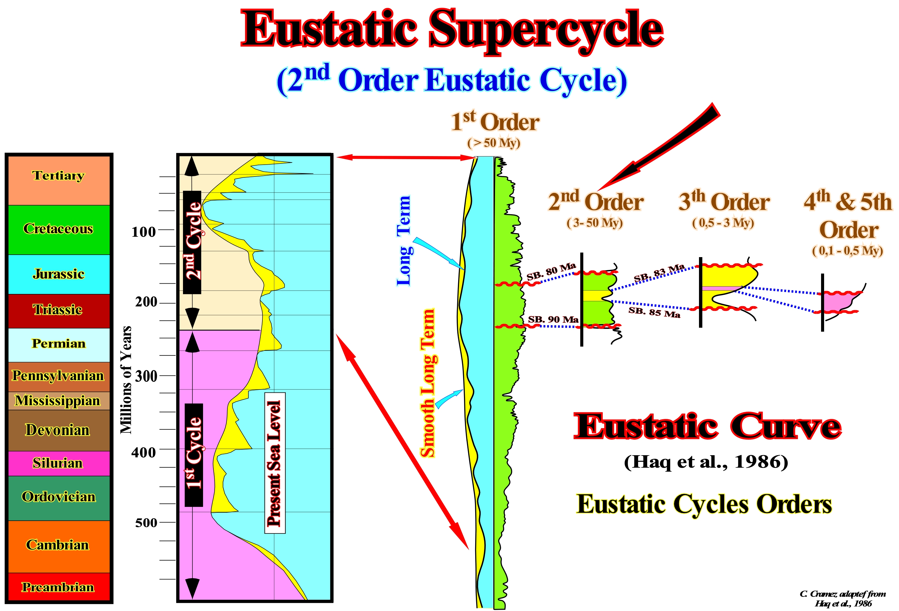
First of all, do not forget that in sequential stratigraphy, sea level can be of two types: (i) Relative sea level, which is the local sea level, referenced to any fixed point on the Earth's surface and (ii) Absolute (eustatic) sea level, which is supposed to be global and referenced to the Earth's centre. The relative sea level is the result of the combined action of absolute (eustatic) sea level and tectonics (subsidence or uplift of the sea floor). The absolute sea level is the result of the combination of: a) Tectono-Eustasy that is controlled by the volume variation of the ocean basins in association with oceanic expansion following the break-up of the supercontinents ; b) Glacio-Eustasy, which is controlled by the volume of water in the oceans as a function of the amount of ice (assuming that the amount of water, in all its forms, is constant since the Earth's formation, ±4.5 Ga) ; c) Geoidal-Eustasy, which is controlled by the distribution of ocean water caused by variations in the Earth's gravity field (where gravity is stronger than normal, sea level is thrown to the centre of the Earth) and d) Steric sea level rise or Thermal ocean dilation (if the temperature increases, the density of the water decreases and, for a constant mass, the volume increases). In the EPR (Exxon Exploration Production Research) relative sea level variation curve, which is outlined in this figure, four major orders of eustatic cycles can be considered: (1) 1st Order Eustatic cycles (former Exxon mega-cycles), which has a time-duration greater than 50 My (usually between 250 and 350 My) and which are induced by the break-up of supercontinents ; (2) 2nd Order Eustatic Cycles (former Exxon super-cycles), which have a time-duration of 3/5 My and 50 My and which are, probably, induced by changes in the velocity of tectonic subsidence (lengthening, cooling and tectonic loading) ; (3) 3rd Order Eustatic Cycles, which have a duration between 0.5 and 3/5 My and which are, probably, induced by glacio-eustasy and (4) 4th to 6th Order Eustatic Cycles, also called high-frequency cycles, which appear to be induced by the climate changes created by the Milankovitch orbital cycles. All these eustatic cycles, and particularly the 3rd order eustatic cycles, which induce the building blocks of sequential stratigraphy, i.e., the sequence-cycles, are formed by eustatic paracycles, i.e. by relative sea level rises (marine ingressions). Between two consecutive eustatic paracycles, as its name suggests, there is no significant relative sea level fall, but a stability period of relative sea level during which deposition occurs, since the available space for sediment increased. As outlined in this figure, it can be said the rocks forming Phanerozoic eonothem were deposited in association with two 1st order eustatic cycles. The first induced the deposition of Paleozoic erathem rocks. It was induced by the breakup of the Proto-Pangea (Rodhinia) supercontinent. The subsequent drift/collision of the continents, caused the changes in the volume of the ocean basins. Assuming that the amount of water under all its forms is constant since the Earth formation (± 4.5 Ga), the absolute (eustatic) sea level changed. The second 1st order eustatic cycle was induced by the break-up of the Pangea supercontinent and by drifting and collisions of the individualized continents. This eustatic cycle allowed the deposition of the rocks of the Mesozoic and Cenozoic erathems. Each of these eustatic cycles, by definition, has a maximum peak (eustatic maximum), which separates the transgressive phase, at the base, from the regressive phase of the associated continental encroachment stratigraphic cycle. The 1st order eustatic cycle consists of four (or five) second order eustatic cycles, whereas the second 1st order eustatic cycle is composed of 8 second order eustatic cycles. Each of these cycles, by definition, has a maximum peak which can still be considered eustatic (global and not relative), which is, probably, not the case for 3rd order eustatic cycles in which sea level variations are relative (combined action of eustasy and tectonics).
Eustatic Variation (Absolute sea level)......................................................................................................Variation eustatique
Variação eustática(nível do mar absoluto) / Variación eustática / Eustatische Schwankungen / 海平面变化, eustatic变化 / эвстатической вариации / variazione eustatici /
Absolute (eustatic) sea level change, on a planetary scale caused by a variation of the volume of water of the global ocean or by variation of the global volume of the ocean basins, etc. Variation in the level of ocean and sea water caused by the increase in the amount of water resulting from the melting of the poles, tectonic movements of the sea floor, sediment accumulation, thermal expansion of the oceans, etc.
See: « Gravity Anomaly »
Eustatism (Eustasy)......................................................................................................................................................................................................Eustatisme
Eustatismo / Eustatismo, Eustasia / Eustasie, Eustatiche Bewegungen Theorie / 海平面升降 / Эвстатика (изменение уровня океана) / Eustatismo, Eustasia /
Eustatism is, sometimes, synonymous with absolute (eustatic) sea level change, when associated with global variations in sea level. Glacio-Eustasy and Tectono-Eustasy are eustatic variations, which are, sometimes, considered globally and uniform. However, for many geoscientists, they can neither be global nor uniform, since any cause of sea level also affects the terrestrial geoid. If this is true, no eustatic curve is valid globally. During the melting ice caps, in response to the load of water added to the ocean basins, the sea level is depressed, and in response to the removed charge (where the ice caps have melted), the continent will be uplift. Redistribution of material within the Earth is affected by overload and will further force variations of the surface of the ocean (induced by gravity anomalies), and thus further redistributions of water will be required to attempt to equalize gravitational potential. This continuous retroactive gravitational process between the ice caps, oceans and the mainland is the process that, in the end, determines the signature of relative sea level, which is observed everywhere the continent and the ocean meet. Note that only glacial changes are both important (> 10 m) and fast (<1 m).
See: « Relative Sea Level Change »
&
« Absolute Sea Level »
&
« Eustasy »
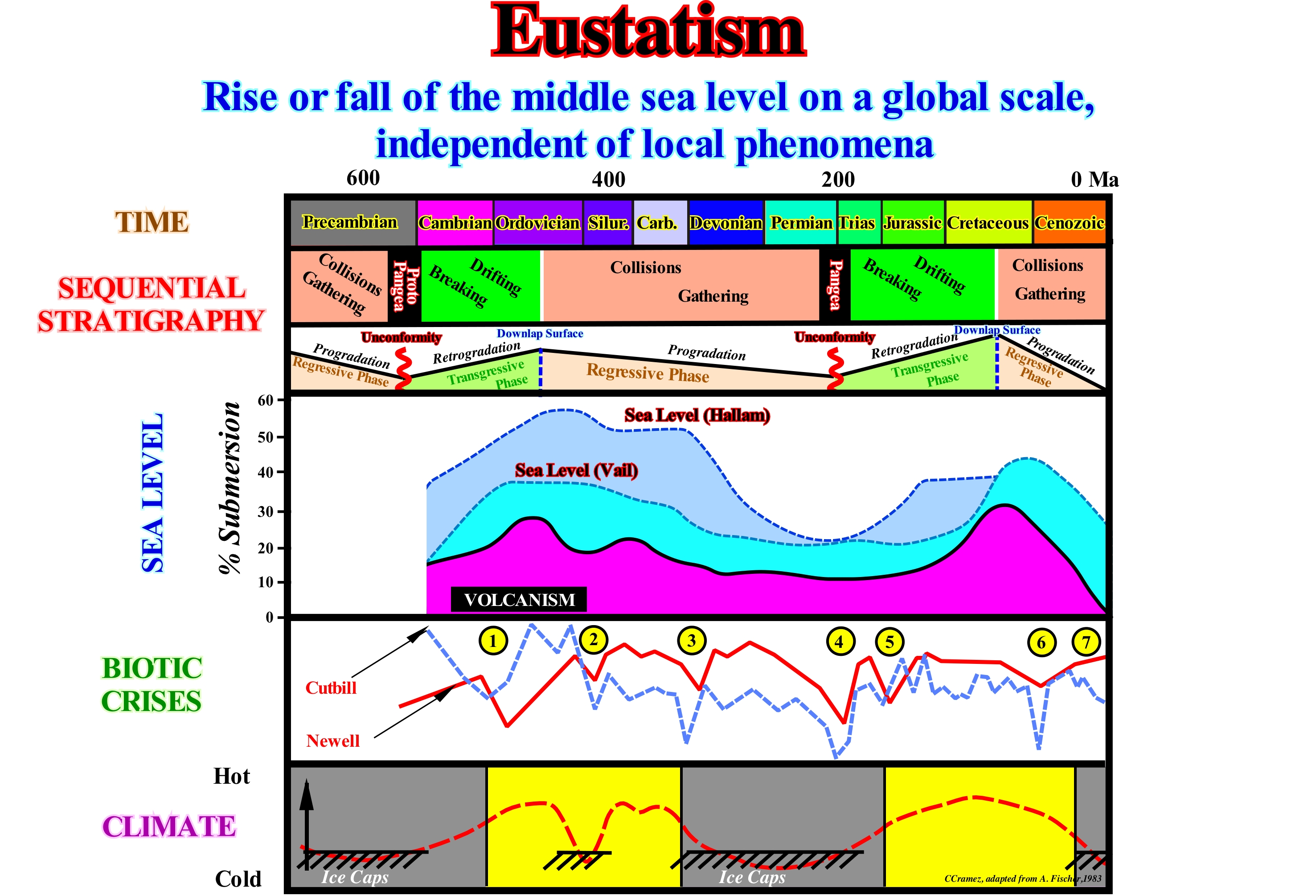
In the lower part of this figure are illustrated the absolute (eustatic) sea level changes proposed by Vail and Hallam during the Phanerozoic. The absolute sea level is supposed to be global sea level, referenced to the Earth's centre. It is dependent on: (i) Tectono-Eustasy that is controlled by the volume variation of the ocean basins in association with oceanic expansion following the break-up of the supercontinents ; (ii) Glacio-eustasy, which is controlled by the variation of ocean water volume as a function of the amount of ice ; (iii) Geoidal-Eustasy which is controlled by the distribution of ocean water caused by variations in the Earth gravity field and (iv) Steric sea level rise or Thermal dilatation of the oceans. Although, the absolute sea level changes of Vail and Hallam show important differences, both suggest two first order eustatic cycles induced by the formation and break-up of the Proto-Pangea (Precambrian) and Pangea (Permian/Triassic) supercontinents. When the supercontinents formed, the absolute or eustatic sea level was low (as well as the volcanic activity). During the dispersion of the individualized continents by the break-up of the supercontinents, the absolute sea level rose, as well as, the volcanic activity. In both first-order eustatic cycles, the maximum height of the absolute sea level was reached at the maximum dispersion of the continents, i.e., at the end of the transgressive phase of each continental encroachment stratigraphic cycles (Ordovician Middle and Cenomanian/Turonian). Put another way, the Paleozoic eustatic maximum, with the absolute sea level higher 200-250 meters than at present-time, occurred at about 500 Ma. The dispersion of the Paleozoic continents was maximum. The Mesozoic/Cenozoic eustatic maximum, with sea level 150/200 meters higher than today, occurred about 91.5 Ma when the dispersion of the post-Pangea continents was maximum. Later, as the continents began to approach each other to finally form a new supercontinent, the level of the absolute (eustatic) sea fell. It reached to a minimum height at the formation time of the of the new supercontinent. Assuming that the amount of water (in all its forms) is constant since the Earth formation (± 4.5 Ga), it is evident that at time of supercontinents , the volume of the ocean basins is large (less dorsal oceanic) and the absolute sea level low. On the contrary, when the volume of the ocean basins is small (abundance of ocean ridges), i.e., when the continents, created by the break-up of the supercontinents, are far apart, the absolute sea level is high. As can be seen in this figure, the curve of absolute (eustatic) sea level (eustatic curve) correlates roughly with the seven (7) biotic crises suggested by Cutbill and Neweel: (1) Cambrian/Ordovician ; (2) Ordovician/Silurian ; (3) Carboniferous ; (4) Permian/Triassic ; (5) Triassic/Jurassic ; (6) Cretaceous/Cenozoic; (7) Holocene. It is possible that transgressions* and regressions** induced by eustasy have a significant influence on the distribution and abundance of ecosystems (community of organisms consisting of producers, composers and decomposers, functionally related to each other and to the environment, and considered as a single entity). When the eustatic sea level was high, the climate seems to have been warm and when eustatic sea level was low climate seems to have been cold. With the exception of glaciation that occurred during the Ordovician, there was no glaciations during the greater part of the Paleozoic period. The same seems to have happened between the Jurassic and Oligocene. However, it is evident-when two curves correlate, one is not necessarily the cause of the other, which many geoscientists tend to forget***. To admit that a "correlation proves causality" is a fallacy known as "cum hoc ergo propter hoc" (with this, therefore, for this). It can just be said the ice ages seems to correlate with: (i) Periods of low absolute sea level ; (ii) Formation of supercontinents (orogenic activity) ; (iii) Low volcanic activity, etc., and it is possible that continental collisions and supercontinent periods facilitate the formation of snow and ice and contribute to climate changes.
(*) Set of increasingly important marine ingressions and increasingly less important sedimentary regressions, which collectively have a retrogradational geometry.
(**) Set of increasingly important marine ingressions and increasingly important sedimentary regressions which, collectively, have a progradational geometry.
(***) Attention to the "pastafariste" argument (F. Meynard, 2011), which on a formal plan consists in claiming that if an event A is correlated with an event B, then event A is the cause of event B, which, of course, can be false because a correlation can be simply the product of simple coincidences.
Eutrophic (Lake)...............................................................................................................................................................................................Eutrophique (Lac)
Eutrófico / Eutrófico (lago) / Eutrophen (See) / 富营养化水体(湖泊)/ Эвтрофное (озеро) / Eutrofico (lago) /
When a lake has more nutrients than it normally should have. An increase in fertilizer results, in general, in an increase in the biological production occurring within the lake. Although increased production increases the lake fill rate, it is incorrect to say that eutrophisation is synonymous with lake aging. A lake dies not when it reaches a great state of productivity, but when it no longer exists (when it is not filled by water). The filling of a lake results from the production occurring inside the lake, which can increase with eutrophisation and the organic and inorganic material formed outside the lake, which has nothing to do with eutrophisation.
See : « Eutrophisation »
&
« Depositional Environment »
&
« Lake »
Since eutrophication increases the amount of nutrients, any change in the drainage basin of a lake that increases the inflow of nutrients causes eutrophication. Any change in agricultural land use, naturally, changes the amount of nutrients in lakes. Studies have shown that: (i) Phosphorus from agricultural land is about 5 times more abundant than that from forest areas ; (ii) In urbanized areas the amount of phosphorus can be 10 times higher. This anomalous amounts destroy ecosystems (composed of producers, composers and decomposers, functionally, related to each other and to the environment, and considered as a single entity). Among the factors that contribute to the eutrophication of lakes are: (i) Lawn and garden fertilizers ; (ii) Defective septic systems ; (iii) Laundries in or near lakes ; (iv) Erosion products entering the lakes ; (v) Dumps or litter lying in lakes, etc. As illustrated in this scheme: (a) High temperature and low oxygen content favour the development of tolerant fish ; (b) Availability of nutrients, especially, phosphorus and nitrogen favour a high density phytoplankton and aquatic vascular plants ; (c) Biomass* of benthic invertebrates is predominant and represented, mainly, by species that tolerate high temperatures and low oxygen and (d) The shallow bottom of a lake reduces the total volume of water, which increases its temperature during summer .
(*) Amount of total matter of living beings living in a given place, measured in weight per unit area or volume or the amount of organic matter originated in a biological process, spontaneous or provoked and usable as an energy source.
Eutrophisation.............................................................................................................................................................................................Eutrophisation
Eutrofização / Eutroficación / Eutrophierung / 富营养化 / Эвтрофикация / Eutrofizzazione /
Increasing of nutrients (foods that an organism needs to live and grow or substances used by the body's metabolism, which are removed from the environment), usually, nitrogen and phosphorus, occurring both on land and at sea. The term eutrophisation is, often, used to designate an increase in the productivity of an ecosystem.
See: « Eutrophic (lake) »
&
« Depositional Environment »
&
« Euxinic (environment) »
Eutrophication, i.e., the excessive increase in nutrients (phosphorus, nitrogen, etc.) of a certain environment or ecosystem is, often, the result of a pollution of nutrients from the rivers either by the water from the sewers or by the water that comes agricultural regions. However, pollution* can, also, occur in a natural way, when nutrients accumulate in depositional environments or when they are transported by ephemeral systems (e.g., intermittent upwelling currents, which are very common in coastal systems). Eutrophication promotes plant growth and decomposition, which favours the preponderance of certain parasitic plants and indirectly causes a severe reduction in water quality. In aquatic environments, the exaggerated growth of certain plants or phytoplankton (plant parts of plankton, consisting of microscopic and filamentous algae) disrupts the normal functioning of ecosystems. Is causes, among other problems, an oxygen deficiency in water, which is necessary for survival, such as, for instance, fish and shellfish. With eutrophication, the water becomes turbid, often, green or even red. All populations suffer from an excess of eutrophication. Decreasing the quality of rivers, lakes and estuaries has direct implications not only on fishing but also on the health of human populations. Since eutrophication interferes with the quality of water that people drink, it is evident that serious health problems can occur. In some areas, excessive algae growth caused by nutrients from agriculture and heavily urbanized areas begins to have a serious impact on the health of populations, although certain ecosystems, such as mangrove swamps, help to reduce eutrophication and problems it creates.
(*) Introduction by man, directly or indirectly, of substances or energy in the environment provoking a negative effect on their equilibrium, thus causing damage to living beings and ecosystems. (https://en.wikipedia.org/ wiki / Pollution)
Eutrophism...................................................................................................................................................................................................................Eutrophisme
Eutrofismo / Eutrofismo / Eutrophisme (Verjüng durch eine Erhöhung der Pflanzennährstoffe) / Eutrophisme (增加植物营养复)/ Эвтрофия / Eutrophisme (Ringiovanimento da un aumento di sostanze nutritive delle piante) /
The process by which a lake is rejuvenated by an increase of nutrients for the plants so that the proliferation of algae on the surface prevents light penetration and oxygen absorption.
See : « Eutrophisation »
&
« Organic Matter (types) »
&
« Sedimentary Environment »
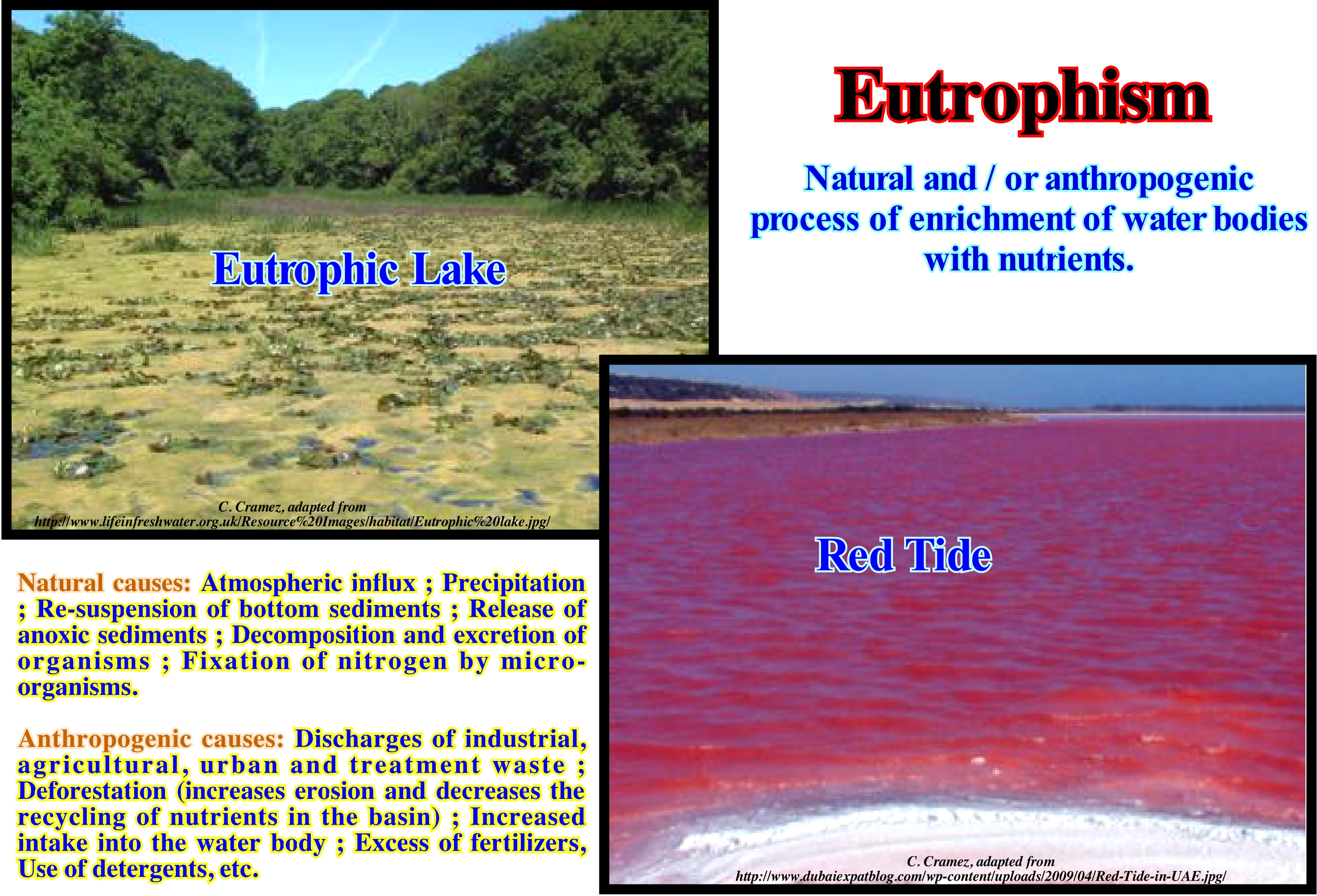
A high nutrient load on fresh-water bodies causes eutrophication. Invariably, this implies an increase in the amount of algae. In some cases, blue-green algae are toxic. When there is an increase in blue-green algae, in more than half of the cases, cows that drink this water die from liver failure. Phytoplankton* can be removed, but leaves a very bad taste in the water. Copper sulfate has been used to try to minimize the growth of algae, but such a method is not only very expensive, but undesirable. The "red tide" is an expression that has been applied when a planktonic (often dinoflagellates) organism blooms in such a way that the water turns red. In most cases, the organism is, highly, toxic and can, quickly, destroy life on the lake. Poison is a liver toxin, but it is not yet very clear why dinoflagellates produce it. Red tides occur in lakes but are not as common as the abnormal blossoming of blue-green algae. They are associated more with brackish water and therefore do not influence potable water- reservoirs in the same way. Both types are becoming more frequent, which is a worrying trend. Even if the water is not potable, the toxins can enter the food chain, once it is consumed by crustaceans and other species that humans eat. Atmospheric pollution has produced an intensification of the greenhouse effect in the last years. This a, more or less, continuous increase of the Earth's temperature caused by the absorption of the infrared radiation, i.e., radiated by the Earth. The consequences of this increase are the climate changes of the planet, the sea level changes, extreme meteorological conditions, etc. The extensive and systematic use of industrial and household fertilizers and detergents has contributed to a progressive increase in eutrophication, which corresponds to an enrichment of the waters with salts, mainly, containing phosphorus and nitrogen and an excessive development of algae in these waters. The most important consequences of eutrophism are degradation of water quality, changes in water flora and fauna, etc.
(*) Set of autotrophic aquatic organisms of the plankton, which have the photosynthetic ability and which live dispersed in the water.
Euxinic (Environment).................................................................................................................................................................................Euxinique (Ambient)
Euxínico / Euxínico (ambiente) / Euxinischen / Euxinic(环境) / Эвксинный / Euxinico (ambiente) /
Environment characterized by a very restricted or stagnant circulation of water and with anaerobic conditions (without or with very little oxygen), such as lagoons, fjords, more or less isolated basins, etc.
See : « Eutrophisation »»
&
« Eutrophism »
&
« Sedimentary Environment »
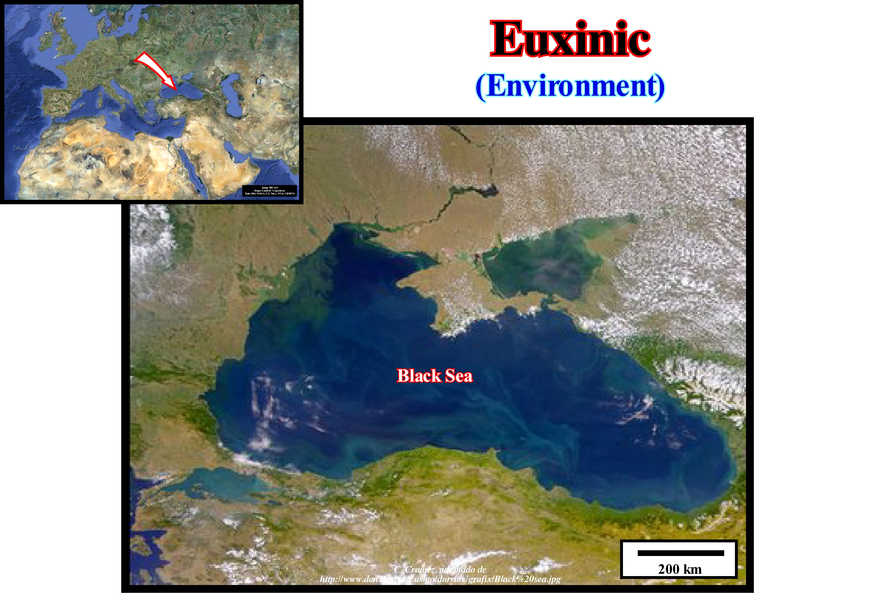
A sedimentary environment is called euxinic when water circulation is restricted or stagnant and when conditions are anaerobic (poor oxygen content), i.e., when breathing is done without the use of atmospheric oxygen. More or less isolated fjords and basins, such as rift-type basins, are euxinic environments. The term euxinic also applies to materials (black organic sediments and muds rich in hydrogen sulphide), which are deposited in euxinic environments, such as in the Black Sea, which is illustrated in this figure. The word euxinic comes from Latin (probably of Greek origin). The Romans called Euxinic Sea or Pontus Euxinic, to which, at the present-time we call Black Sea, i.e., the water-body limited by Turkey, Bulgaria, Romania, Russia and some of the former Soviet republics. In Black Sea, i.e., in the sea of dark waters, the visibility does not exceed 5-6 mm deep (shallow photic zone). It contrasts with the Mediterranean sea, in which the visibility exceeds 30 m depth. In an aerial photograph, as shown in this figure, it is easy to see that the Black Sea is about 1200 km wide (maximum width) and has a very dark colour due to the large amount of organic matter dissolved in the water. The water flows through the Bosphorus, near the city of Istanbul, to the Marmara Sea and then Mediterranean Sea through the Aegean Sea. It is important not to forget, that the organic matter deposited in a euxinic environment do not decompose. It is for this reason that sediments rich in organic matter, such as black clayey rocks, that are, often, potential source-rocks, deposit in lacustrine environments and, in particular, in the rift-type basins formed before the breakup of the supercontinents. Later, when organic matter reaches maturation, they generate large quantities of hydrocarbons that can be economically produced, as is the case in the offshores of Angola and Brazil.
Euxinism......................................................................................................................................................................................................................................Euxinisme
Euxinism / Euxinismo / Euxinisme (Prozess) / Euxinisme(过程) / Эвксинный / Euxinismo (processo) /
Set of conditions that characterize a restricted and stagnant or anaerobic water circulation environment.
See: « Euxinic (environment) »
&
« Eutrophism »
&
« Organic Matter (types) »
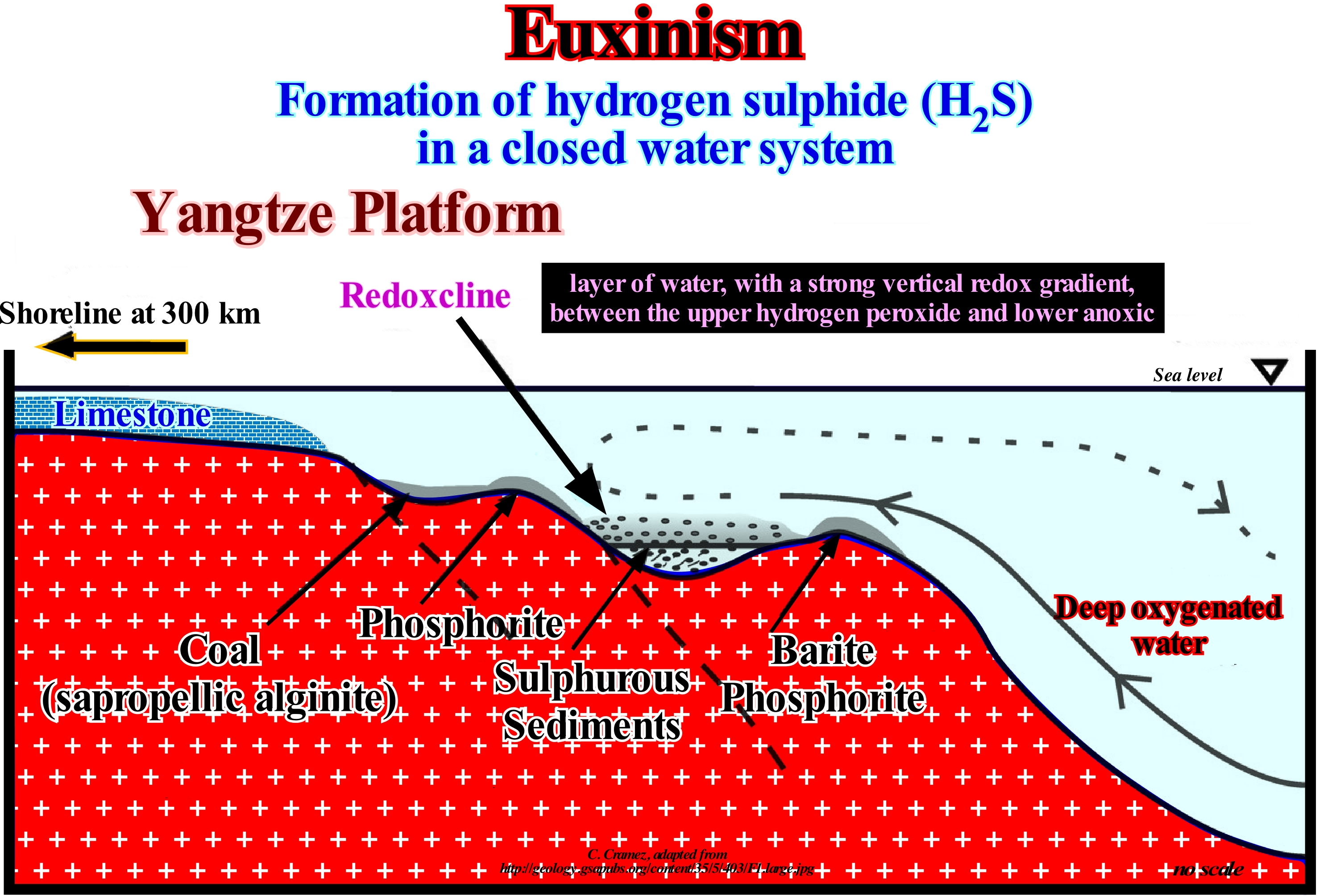
Literally, euxinic means "belonging to the Black Sea". The word euxinic comes from the ancient Roman (and, initially, of the Greek), name for the Black Sea. The Romans called Euxino Sea or Pontus Euxinus. Black Sea water is highly stratified, with an oxidized upper layer and an anoxic bottom layer (without oxygen). Fresh water flows into the sea from rivers like the Danube, Dniester, Dnieper and Don. Sea-water flows into the Black Sea from the Mediterranean through the Bosphorus strait. Due to the different salinities and densities, fresh-water and sea-water mix only in the first 10-150 meters of depth. The mixing between the surface water and the bottom water is, severely, limited. It takes more than 1,000 years to renew the deep-water. As oxygen is necessary for the decomposition of organic matter, under anoxic conditions organic matter does not rot. As a result, black sediment rich in organic matter accumulates in the bottom. The name Black Sea comes from the colour of the sediments responsible for the black water colour. Unlike the Mediterranean where visibility reaches a depth of about 30 meters, the visibility in the Black Sea is only only about 5 meters deep. The decomposition of organic matter by the action of bacteria and fungi is a process, which occurs under aerobic conditions, that is in the presence of oxygen. There is also bacterial activity under anaerobic conditions, i.e., occurring in the absence of oxygen. Under anaerobic conditions at the bottom of the Black Sea, sulfate reducing bacteria draw oxygen from sulfate and reject hydrogen sulfide (H2S)). Some of the hydrogen sulphide may react with the iron to form pyrite (FeS). An increase in pyrite in sediments is an indication of the sulfate/reducing activity. The term euxinism translates the processes that occur in an environment of restricted and stagnant circulation, under anaerobic conditions. Euxinic conditions are at the same time both anoxic, anaerobic and hydrogen sulfide, where H2S dissolved in water inhibits life and in which euxinic sediments such as sapropel are deposited.
Evaporite.......................................................................................................................................................................................................................................Évaporite
Evaporito / Evaporita / Evaporite / 蒸发 / Евапорит (отложение вследствие испарения морской воды) / Evaporite /
Mineral or rocks (for some geoscientists) that dissolves in water and forms by evaporation of bodies of surface water. Although all surface water-bodies, as well as, more or less deep aquifers, contain dissolved salts, the water must evaporate for the minerals to precipitate. For this to happen, the water-body must be in a restricted environment and in which the water inlet is less than evaporated water, which is the rule in arid environments. As evaporation occurs, the remaining water is enriched in mineral salts that precipitate as long as it becomes saturated.
See: « Compensatory Subsidence »
&
« Halokinesis »
&
« Sabkha »
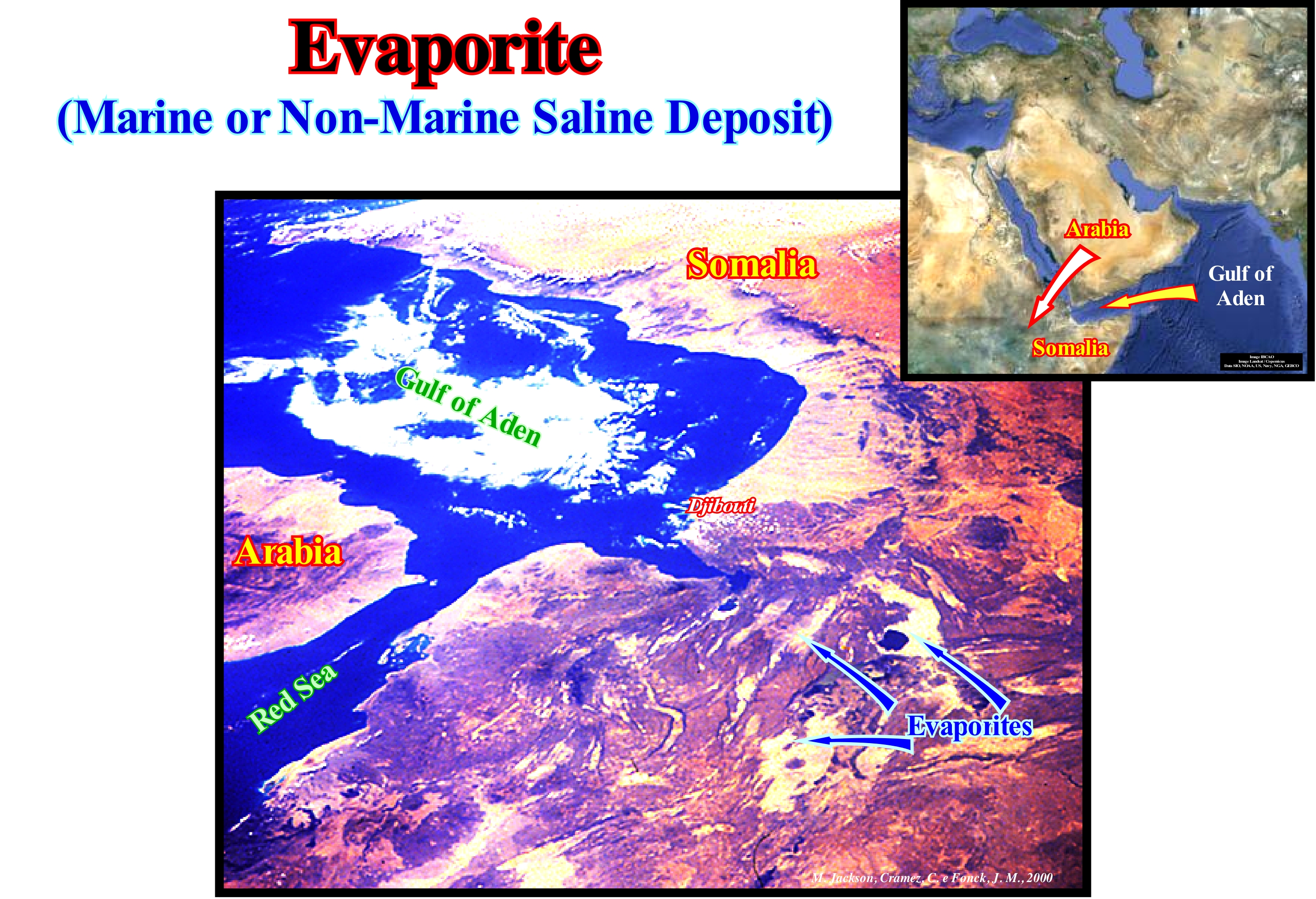
The term evaporite refers to the deposits resulting from the evaporation of waters loaded with dissolved salts. When evaporation occurs, the minerals deposit in a certain order. When it is about the sea-water the order of deposition is as follows. (i) Gypsum (CaSO4,2H2O) ; Anhydrite (CaSO4) ; Halite or gem salt (ClNa) ; Carnalite (KMgCl3, 6H2O) ; Silvite (KCl), etc. However, this order is just respected when the evaporation is complete. Otherwise, only the first elements of the list are deposited. In general, evaporite deposits occur, frequently, in: (i) Rift-type basins (grabens or half-grabens) formed in nonmarine environments and fed by rivers with a, relatively, small drainage basin, as for instance, in the Denakil Depression (Ethiopia) or Death Valley (California) ; (ii) Grabens associated with ocean basins, more or less, isolated, poorly fed and highly evaporated, such as the Red Sea and Dead Sea (Jordan) ; (iii) Internal drainage basins in arid semi-arid environments, fed by an ephemeral drainage network, such as in the Simpson Desert (Western Australia) and Utah's large salt lake ; (iv) Areas fed just by groundwater, such as the Victoria desert in Australia ; (v) Coastal plains of regressive marine environments such as the Sabkha deposits of Iran and (vi) Drainage basins that feed, extremely, dry environments such as in parts of the Sahara and Namibian desert. The evaporites illustrated in this photograph have a very particular origin. They result from the evaporation of enriched brines, especially potassium and magnesium, due to the spilitisation of subaerial lavas which have been deposited in association with the break-up of the Pangea supercontinents. These evaporites, which have their own characteristics (very rich in magnesium and noble minerals, such as gold and silver) are frequent in the Atlantic (North and South) continental divergent margins as well as in the Gulf of Mexico.
Evaporite on Sebkha Saline..............................................................................................Évaporite en sabkha saline
Evaporito (em sebkha salina) / Evaporita en sabkha salino / Evaporite auf sebkha Kochsalzlösung / 蒸发盐水上盐沼 / Эвапорит в солончаковой пустыне / Evaporite su sebkha saline /
Evaporite mineral deposited in sabkhas. These evaporites form within sediments by evaporation of capillary brines or as ephemeral surface crusts. Only the evaporites that precipitate between the sediments can be preserved and, therefore, they are the ones that characterize the old sabkhas.
See: « Sedimentary Environment »
&
« Halokinesis »
&
« Sabkha »
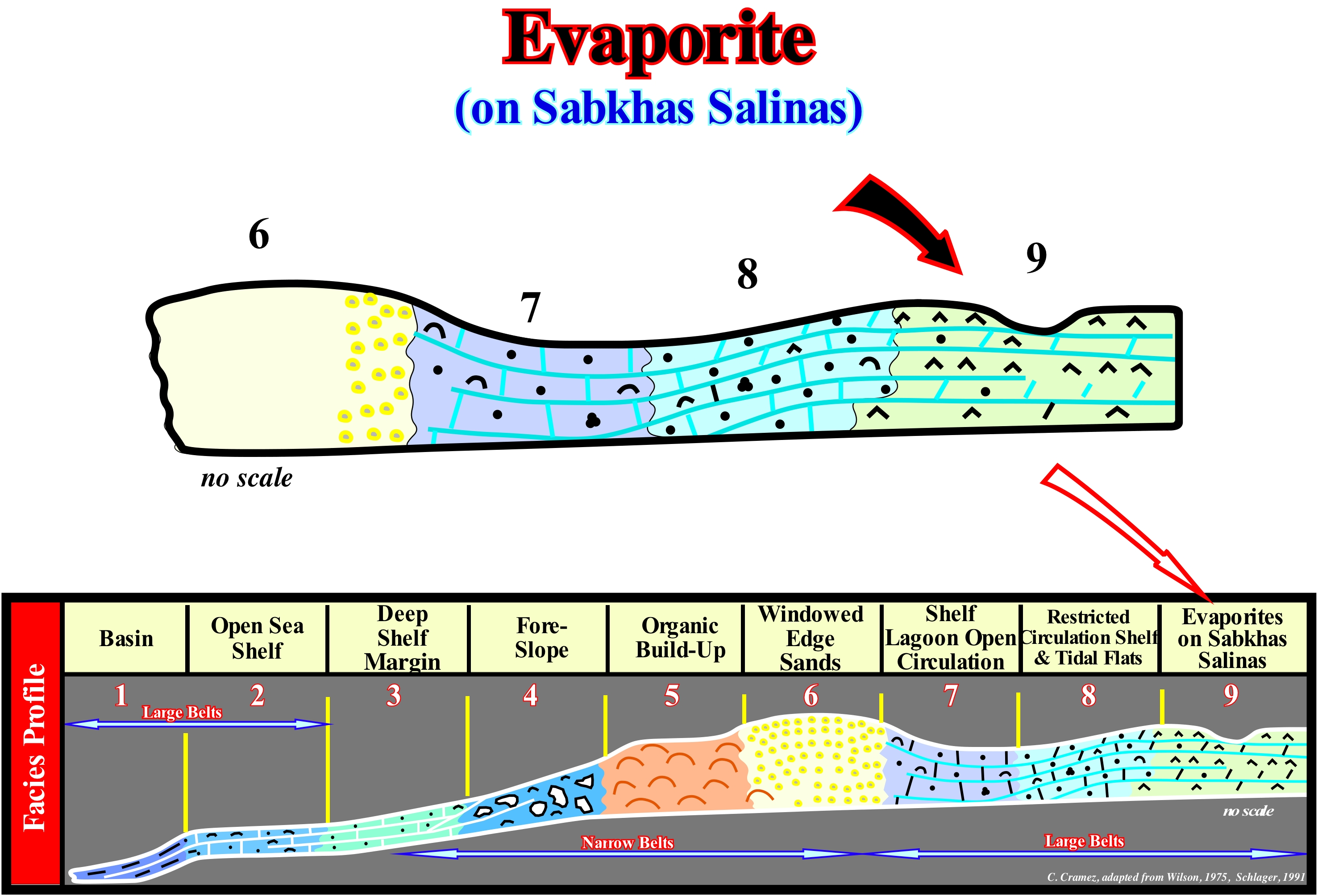
Many of the characteristics of coastal sabkhas are identical to those of the ooze or mud plains or of the sandy tidal flats of the "playa" systems. The sabkhas can be distinguished just by their paleogeographic position, relations with adjacent facies and, in certain cases, by their mineralogy and geochemistry. From the moment the geoscientists realized that to deposit a significant thickness of evaporites (continental or marine) a stable brine is required for at least 100 to 1,000 ky, it is evident that the recent sabkhas are not significant. The high amplitude of the 4th order eustatic cycles of our current climate does not allow the formation of stable brines behind the sandbars of the present-time carbonated platforms. This is why Neogene carbonate platforms with evaporites are rare. At present, the vast majority of geoscientists think the large accumulations of evaporites are associated with the break-up of the supercontinents (Proto-Pamgea and Pangea) and, probably, without great influence of the climate. Since the supercontinents fracture, huge amounts of sub-aerial lavas are deposited. These lavas are covered by the sea, and since the oceanic crust forms (immersion of the volcanoes associated with the expansion centres), the sea-water reacts with the lavas and creates a brine that is, progressively, enriched in potassium and rare minerals due to spilitisation* of basalts. That is why the chemical composition of the evaporites of the Atlantic divergent margins (Angola, Congo, Brazil, Baltimore Canyon, Lusitanian Basin, etc.) is very different from the evaporites formed during the Messinian, in the Mediterranean Sea or evaporites from the salt flats. A current model for the formation of potassium-rich evaporites and the enrichment of brines by spilitisation of basalts in a non-marine environment is the triple point of Ethiopia.
(*) Transformation of basalt or andesite by a metasomatic phenomenon produced by hydrothermal circulations whose result is the appearance of spilites, i.e., a fine-grained igneous rock, resulting, particularly, from alteration of oceanic basalt, composed, mainly, of albite or oligoclase, together with chlorite, epidote, calcite ans actinolite basalt.
Event (Geological)......................................................................................................................................................................................Événement (Géologique)
Acontecimento, Evento / Acontecimiento (geológico) / Geologische Ereignis / 地质事件 / Геологическое событие / Evento geologic /
All that can happen and contribute to Earth's history. The geological events can be: (i) Regular (one every 100 years); (2) Common (one every 1,000 years); (iii) Recurrent (one every 1 x 10⁶ years); (iv) Occasional (one every 10 x 106 years) and (v) Rare (one every 1 x10⁹ years). A rare geological event, on a human scale, is a common event in stratigraphic records.
See: « Stratigraphic Cycle »
&
« Completness »
&
« Geological Time »
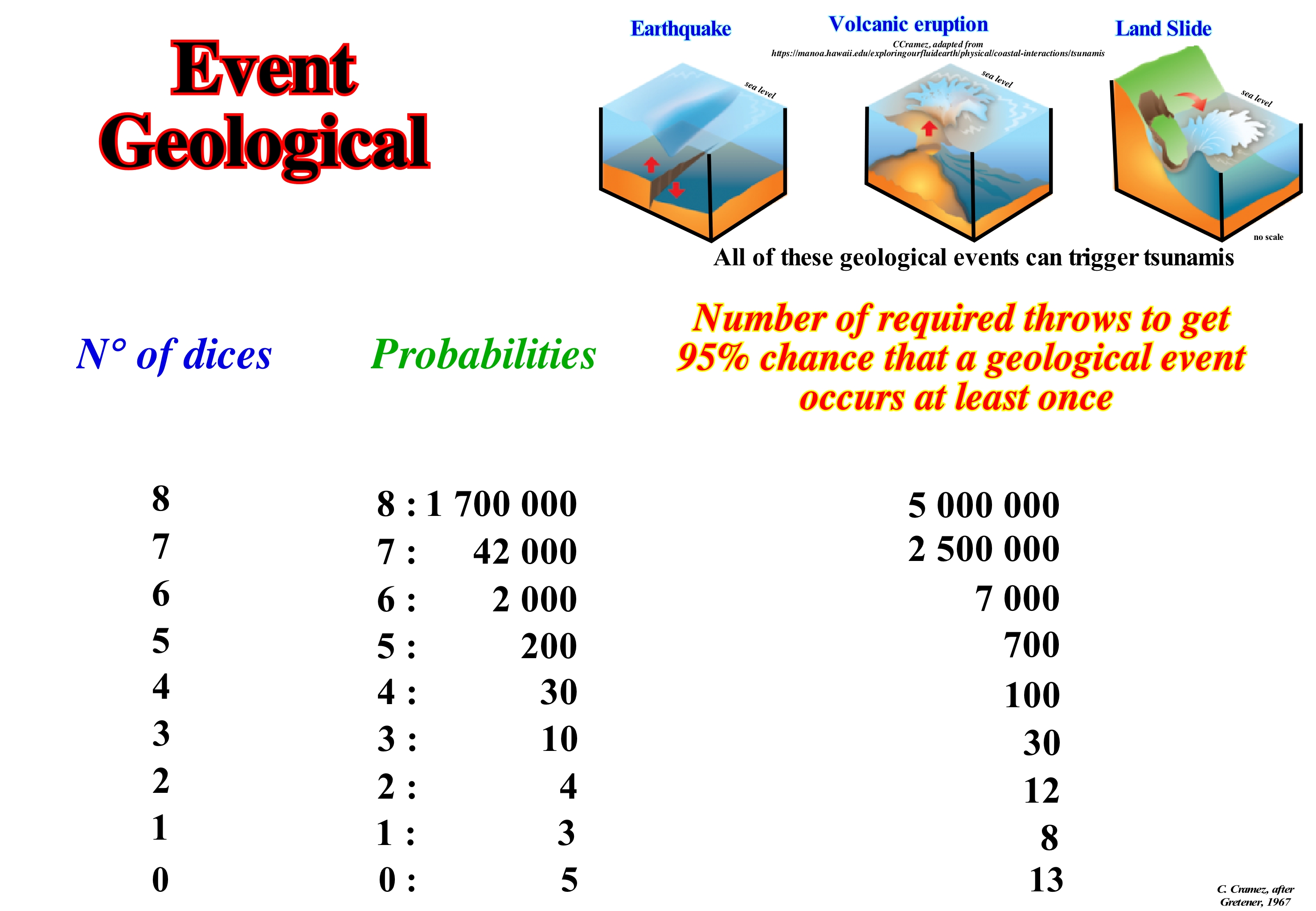
To quantitatively define the concept of geological event, such as an earthquake, relative sea level rise (marine ingression), volcanic eruption or a landslide, Gretener (1967) used a dice game. As a natural event depends almost always on the simultaneous occurrence of several factors, the probability of occurrence of such an event is the product of the probabilities of occurrence of the different factors. The formation of an oil accumulation, for instance, depends mainly on five parameters: (i) Source-Rock ; (ii) Trap ; (iii) Maturation of the organic matter of potential source-rock ; (iv) Age of migration of hydrocarbons in relation to age of trap formation and (v) Retention. The probability of discovering an oil accumulation (economic or otherwise) is the product of the probabilities of these five petroleum parameters. If the probability of a parameter is zero (0), the probability of discovery will be zero (0). If the parameter Source-rock (presence and maturation of organic matter) is zero (0), i.e., if there is no source-rock in the region capable of generating hydrocarbons, the study of the other petroleum parameters is useless. This is why many geoscientists regard the source-rock parameter as a "killer parameter". In a game of octahedron dice game (its eight faces are triangles and are numbered 1 to 8), the probability of get 8 times the face 6, when all the dice (eight dice) are thrown is 1 in 2 x 10⁶ of throws. However, as the number of throws increases, the probability of obtaining a throw with an eight-sided 6 increases, too. Theoretically, as illustrated in this figure, there is a 95% probability of obtaining, at least once, eight (8) faces with the number six in a total of about 5 million throws and 95% of probability of not obtaining at least one time, no face with number six in 13 throws. All this means that: (i) At the human scale (2-3 generations time), a small probability of occurrence of a certain geological event is considered as an impossibility, although there is no natural law that prevents this event from happening and (ii) What is, practically, impossible, on a human scale (a collision of an asteroid with the Earth, for example) is just unlikely at the geological scale. In order to understand the meaning and importance of a geological event, it is equally important not to forget that a stratigraphic system, such as Silurian, is occasional and incomplete. It has numerous gaps (periods without deposition or erosion). In general, stratigraphic systems do not translate the equivalent geologic time interval, but just the time during which deposition occurred. The sedimentary completeness of a stratigraphic interval, which certain geoscientists call sedimentary integrality (ratio of actual deposition time to total interval time) and the preservation of a deposit are important elements. All geoscientists know that the sedimentary completeness of a turbidite layer is, more or less, 1, while that of a pelagic clay is largely lower than 1. A beach lamination deposit is deposited, more or less, in a second. A hummocky cross stratified layer (HCS layer), characteristic of storm deposits, is deposited in a few minutes. A turbidite layer deposits in a few hours. Flood deposits, such as the Canadian Scablands (deposits and erosions associated with flooding caused by the rupture of the retention of lakes located behind Pliocene-Pleistocene glaciers), are deposited in a few weeks. The glacial varves deposit in a year. One centimetre of pelagic sediments is deposited in about 103 years. A continental encroachment sub-cycle deposits between 10 and 20 x 106 years. A continental encroachment cycle is deposited at 100 and 200 x 106 years. Imagine a stratigraphic interval composed of 100 layers of turbidite and pelagic clay, where each turbidite layer has a thickness of 10 cm and each pelagic layer has a thickness of 5 cm. The total thickness will be 1,500 cm. Since the mean deposition velocity of the pelagic clays is about 5 cm/1000 years and the turbiditic currents are instantaneous stratigraphic events, we can say: (i) The total deposition time is 100 ky ; (ii) The frequency of the turbidite currents is 1 ky ; (iii) Two-thirds of the sedimentary interval was deposited by instantaneous events whose frequency is one event per thousand years ; (iv) In 10 million years, 10,000 geologically instantaneous events can deposit a 1,500 m thick section.
Evorsion..............................................................................................................................................................................................................................................Evorsion
Évorsão / Evorción / Evorsion (Geologie) / Evorsion(地质) / Эворзия / Evorsion (geologia) /
Process of formation of kettles in the bed of rivers, which has a very important role in denudation. Evaporation corresponds to mechanical erosion induced by water swirls that carry sand, gravel or even boulders in suspension or as a basal load.
See: « Erosion »
&
« Pothole »
&
« Relative Sea Level Fall »
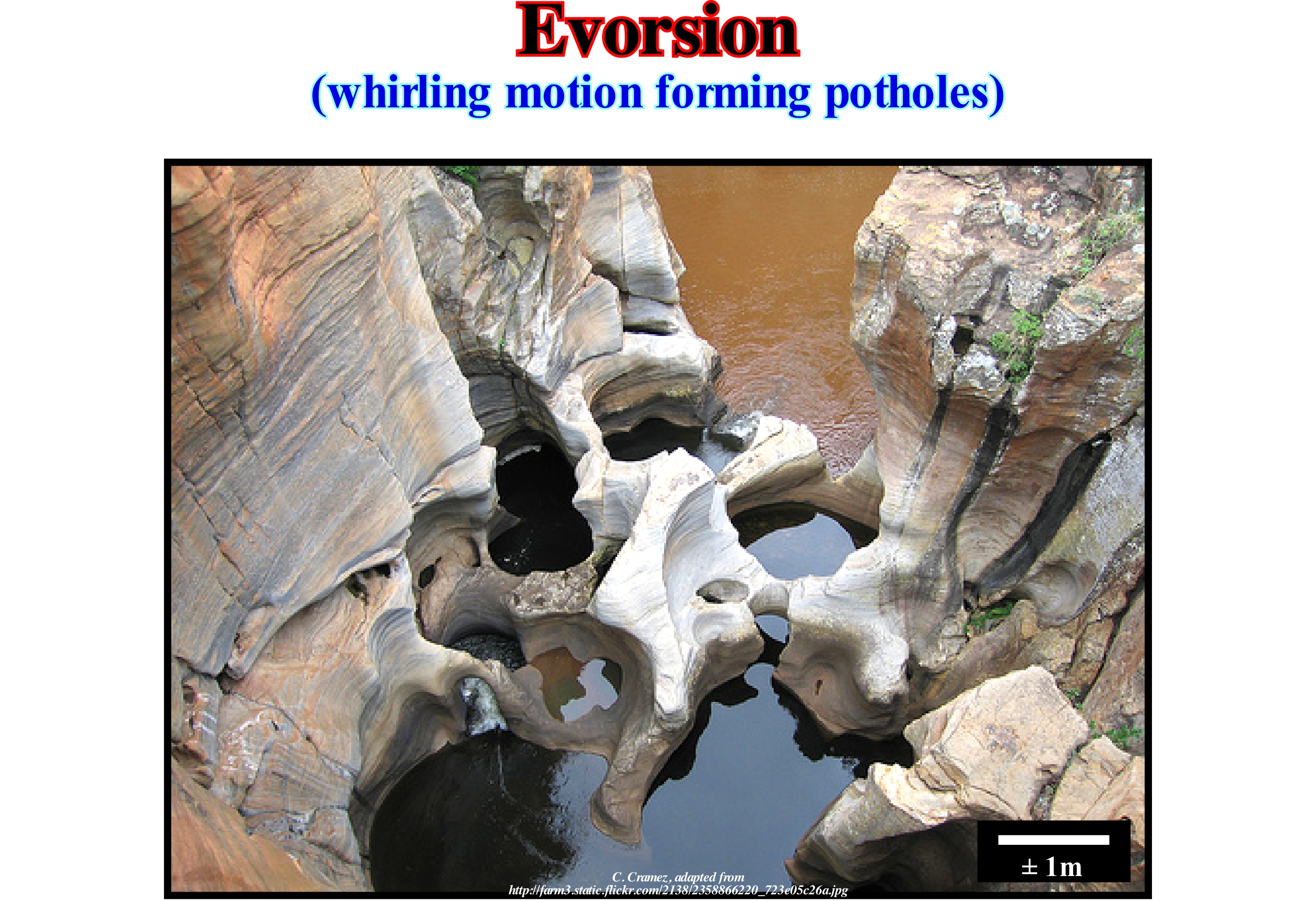
Giant cauldrons or river-bed holes, as illustrated in this figure, are cavities or holes drilled into the surrounding rocks by whirling streams of water containing stones, gravel, and other detrital materials. It is this type of mechanical erosion by swirling water that carries sand or gravel which certain authors call evorsion. The size varies from a few centimeters to several feet deep and diameter. The most common occurrence is in cratons, where there are old rocks (granite, gneiss, etc.) with different resistance to erosion and in particular to the erosion of rocks that run in a small cavity and that, gradually, increase its depth and diameter. In areas where there are diamonds and quartz rocks, the hardness of these minerals digs deep holes, and sometimes diamonds or quartz crystals remain trapped in the bottom of such cavities. The hardness of the stones should be equal to or greater than the hardness of the bottom of the river, where the pothole is forming. That is why these potholes are a good place to find diamonds (as is the case in certain rivers in Angola). Giant potholes can also form when the terrain is covered by a glacier. The water, produced by the thawing of ice and snow, forms currents on the surface of the glacier, which contains a certain amount of debris, and that when gathered in a more important current that falls in a fissure or crevice it forms a swirling cascade with a great power of evorsion. The sides of the crevisses are worn, and a vertical axis is formed on the ice. Erosion can continue on the glacier's bed forming giant potholes (kettles*) either empty, either filled with gravel, sand or rocks. These cavities can be an important proof of the extent of glaciers. A very famous location for its giant potholes is the Gletschergarten in Luzern (Switzerland), where there are 32 giant potholes, the largest being about 8 m wide and 9 m deep. There are also important potholes in Germany, Norway, Sweden, Finland, etc.
(*) Depressions created by the melting of an ice block (dead ice) buried in a shallow moraine.
Exhumed Shelf.........................................................................................................................................................................Plate-forme exhumée
Plataforma exumada / Plataforma exhumada / Exhumiert Plattform / 掘出台地 / Выкапывать из породы платформа / Piattaforma riesumata /
When a relative sea level fall is large enough to put the sea level below the basin edge. Such a fall in relative sea level creates Type I unconformity and lowstand geological conditions.
See: « Relative Sea Level Fall »
&
« Drowned Shelf »
&
« Lowstand »
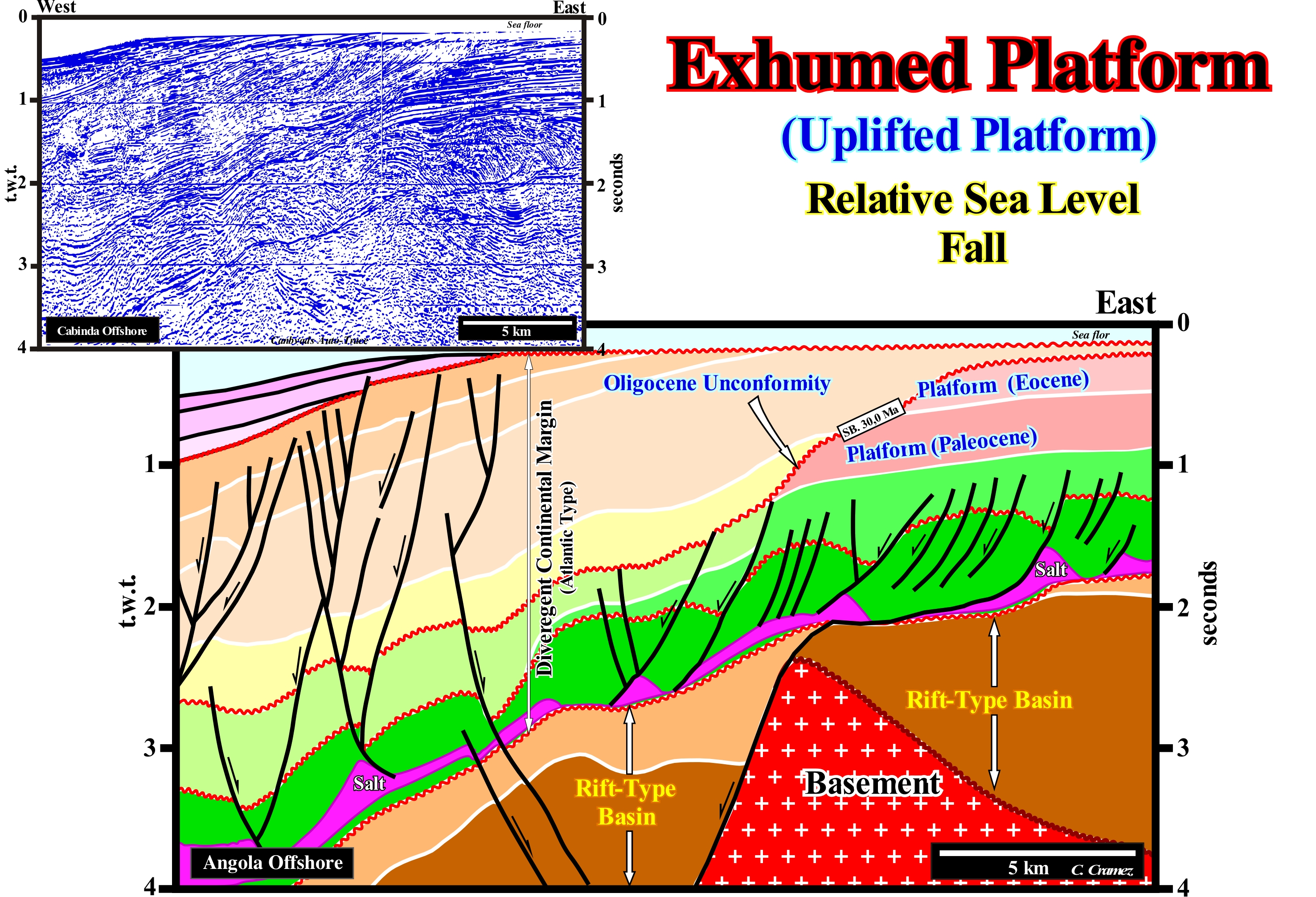
On this tentative geological interpretation of a Canvas auto-trace of a seismic line of the offshore North of Angola, from bottom up, it is easy to recognize several basins of the classification of the sedimentary basins of Bally and Snelson (1980): (i) Basement that, in the most of cases, corresponds to a flattened Paleozoic mountain folded range or to Precambrian granite-gneisses ; (ii) Rift-type basins, formed before the break-up of the lithosphere (coloured in dark brown and light), and in which, in the north offshore and onshore, lacustrine rocks rich in organic matter (potential source-rocks) and sandy reservoir-rocks were deposited ; (iii) Atlantic type divergent continental margin (developed in a tectonic context, globally, extensional), which can be sub-divided in two major intervals: a) Supra-salt Interval composed by: a.1) Sediments of the transgressive phase of the continental encroachments cycle, characterizers by a retrogradational geometry (although the sediment is deformed by halokinese) and a.2) Sediments of the regressive phase of the continental encroachment cycle with a pronounced progradational geometry and b) Infra-salt interval limited between the break-up unconformity and the bottom of the evaporitic interval or by a salt weld. Currently, the evaporitic horizon is, more or less, discontinuous (coloured in violet). Before the break-up of the lithosphere, during the lengthening phase of the Gondwana small supercontinent, the formation of the rift-type basins was associated with differential subsidence (half-grabens structures). After the break-up of the lithosphere, i.e., during the oceanic expansion (sea floor spreading), a cooling of the lithosphere induced a thermal subsidence that became predominant. This tentative geological interpretation, which was done in continental encroachment sub-cycles, induced by eustatic cycles with a time-duration ranging between 3-5 and 50 Ma, strongly suggests a significant absolute* (eustatic) sea level (global and referenced to the Earth's centre or to a satellite) during the Oligocene. Such a sea level fall induced the unconformity SB. 30 Ma (between the Rupellian and Chatian). It was, sufficiently, important to exhume the Eocene platform, as well as, the upper part of the continental slope (near the basin edge). This sea level (absolute) fall seems to have been caused by a glaciation (glaciers and the Antarctica ice cap formation), created lowstand geological conditions that led to a seaward and downward of the coastal onlaps. Turbidite depositional systems were deposited in the deep parts of the basin. On the other hand, as suggested by the reflectors terminations against the sea floor (toplaps by truncation), the proximal part of the divergent margin was lifted, during the Late Tertiary. The old Paleocene and Eocene, platforms which had been fossilized by the coastal onlaps of the Late Tertiary progradations (continental slope) are, clearly,, deformed. The exhumed sediments by the Late Tertiary uplift were, partially, eroded. This erosion was, certainly, amplified by the fall (± 120 meters) of the relative sea level (local sea level referenced to any point on the Earth's surface, such as the sea floor or the base of the sediments). This relative sea level fall was the result of the combined action of tectonics and absolute sea level induced, mainly, by the Quaternary glaciations, during which most of the sequence-cycles had no highstand sedimentary systems tracts (basin without shelf). However, since the thaw began about 19,000 years ago, the absolute sea level rose and flooded the coastal plain, which became a continental shelf, as can be seen on this tentative interpretation.
(*) The absolute (eustatic) sea level is dependent on: (i) Tectono-Eustasy which is controlled by the volume variation of the ocean basins ; (ii) Glacio-Eustasy, which is controlled by the variation of ocean water volume as a function of the amount of ice ; (iii) Geoidal-Eustasy which is controlled by the distribution of ocean water caused by variations in the terrestrial gravity field and (iv) Thermal expansion of the oceans or Steric sea level rise (if the temperature of the oceans increases, the density of the water decreases and , for a constant mass, the volume increases).
Exogen (plant).................................................................................................................................................................................................................................Exogène
Exógena / Exógeno / Exogen (Geologie) / Exogen(地质)/ Экзогенный / Esogene (geologia) /
Woody plant whose stem is formed by successive additions and to the outside of the wood under the bark.
See: « Stromatolithe »
&
« Endogen (plant) »
&
« Infauna »
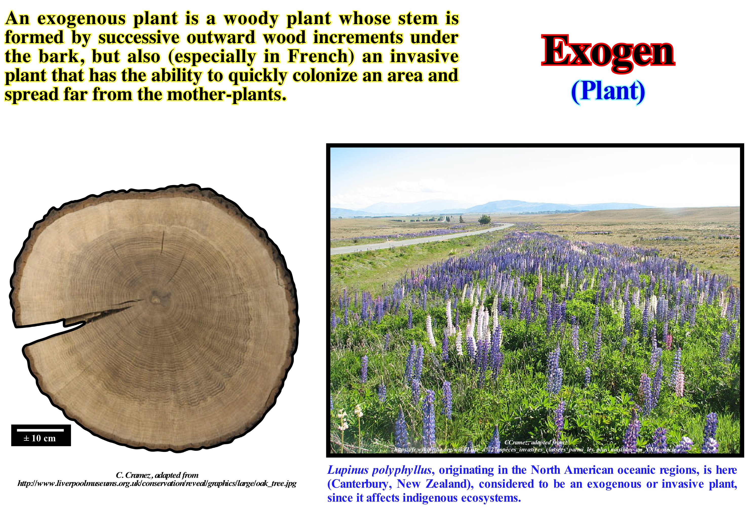
Dendrochronology or dating of the trees by their rings is the scientific method of dating the exogenous plants. Dendrochronology, as illustrated in this figure, allows us to calculate the age of an exogenous tree using the wood rings. This methodology has three main areas of application: (i) Paleoecology, where it is used for certain aspects of the ecology of the past (the most important is the climate) ; (ii) Archaeology, where it is used to date ancient buildings, etc., and (iii) Radiocarbon dating, where it is used to calibrate the ages determined by radiocarbon. The growth rings, also known as annual rings, can be seen in a horizontal cross-section of a trunk of a cut tree, as illustrated above. Growth rings are the result of a new growth in the plant cell tissue - lateral meristem, i.e., the tissue in all the plants that is found in the zones of the plant where the growth can occur, which is synonymous of secondary growth. The visible rings result from the change in growth velocity during the seasons. A ring underlines a year of tree life. The rings are more visible in temperate zones, where the seasons differ more sharply. The inner part of a growth ring is formed at the beginning of the growing season, when the growth is relatively rapid (hence the wood is less dense) and is known as "early wood" or "spring wood" or "wood of late spring ". The outer part is the "late wood" and sometimes called "summer wood", often being produced in the summer, although sometimes also in autumn and is denser. The term "early wood" is preferably used for "spring wood" since the latter term may not correspond to that time of year in climates where timber is formed in early summer (such as in Canada ) or in autumn, as for some species of the Mediterranean. Many trees in temperate zones make a ring of growth every year, with the most recent on the bark. Throughout the life of a tree, a standard ring is formed, which reflects the climatic conditions in which the tree grew.
Exhoreic (Hydrography)..............................................................................................................................................................Exoréique (Hydrographie)
Exorréica / Exorréica (hidrografia) / Exorheic (Hydrographie) / 外流 (水文) / Экзореический / Exorheic (Idrografia) /
When the drainage is done, directly, to the sea. The drainage is arheic when there is no runoff. It is cryptorheic if the water seeps into the soil by sinks.
See: « Drainage Basin »
&
« River »
&
« Endorheic (hydrography) »
This type of drainage, in which the river flows directly into the sea, is the most important in sequential stratigraphy. The relative sea level* changes (combination of eustasy and tectonics, whether this is manifested by subsidence or by uplift), which are responsible for the unconformities (erosional surfaces) can be deduced, at least partially, by the exorheic hydrographic network. At a significant relative sea level fall, the mouth of the exorheic rivers, is displaced seaward, which means that the coastal onlaps move seaward and downward. Such a displacement breaks the provisional equilibrium profile of the rivers (the definitive equilibrium profile is never reached), forcing the rivers to dig the beds so that a new provisional equilibrium profile can be reached. This seaward displacement of the shoreline creates lowstand geological conditions, and develops an erosional surface, i.e., an unconformity, which, sometimes, especially when it is not tectonically enhanced, is difficult to recognize. It is the recognition, in the field or on the seismic lines, of incised valley fillings, during the terminal phase of lowstand prograding wedges, that, often, allows geoscientists to locate the unconformities (boundaries of the stratigraphic-cycles). This is particularly true upstream of the continental edge (which may or may not coincide with the basin edge). In most cases, during a significant relative sea level fall, erosion occurs, mainly, near the continental edge (submarine canyons) and in the areas adjacent to the water-courses (riparian erosion). When the relative sea level rises (the final part of the lowstand prograding wedge deposition and, especially, during transgressive interval (sequence-cycle), the mouths of the exorheic water-courses are displaced upstream. There is a retrogradation of the shoreline (coastal onlaps, as well as coastal deposits are displaced upward and continental), which can often induce overbank deposits and, in particular, natural marginal dikes (levees).
(*) There are two types of sea level: (i) Relative and (ii) Absolute or eustatic. Relative sea level is the result of the combined action of absolute (eustatic) sea level and tectonics (subsidence of sea floor, when the sediments are lengthened or uplift when the sediments are shortened, although in certain cases, when there is diapirism, the sediments can be lengthened). Relative sea level is referenced to any point on the Earth's surface as the sea floor or the base of the sediments (top of the continental crust). The absolute (eustatic) sea level is the global sea level, referenced to the Earth's centre. It is dependent on the : (i) Tectono-Eustasy that is controlled by the volume variation of the ocean basins in association with oceanic expansion following the break-up of the supercontinents, (ii) Glacio-Eustasy, which is controlled by the variation of ocean water volume, depending on the amount of ice ; (iii) Geoidal-Eustasy which is controlled by the distribution of ocean water caused by variations in the Earth gravity field and (iv) Thermal dilation of the oceans or steric sea level rise.
Exponential Growth.......................................................................................................................................Croissance exponentielle
Crescimento Exponencial / Crecimiento exponencial / Exponentielles Wachstum / 指數增長 / Экспоненциальный рост / Crescita esponenziale /
When the growth rate of a mathematical function is proportional to the value of the function. In the case of a discrete domain of definition, with equal intervals is also called geometric growth or geometric decay (function of values forms a geometric progression).
See: « Logistic Curve »
&
« Hubbert's Curve »
&
« Deposition (carbonates) »
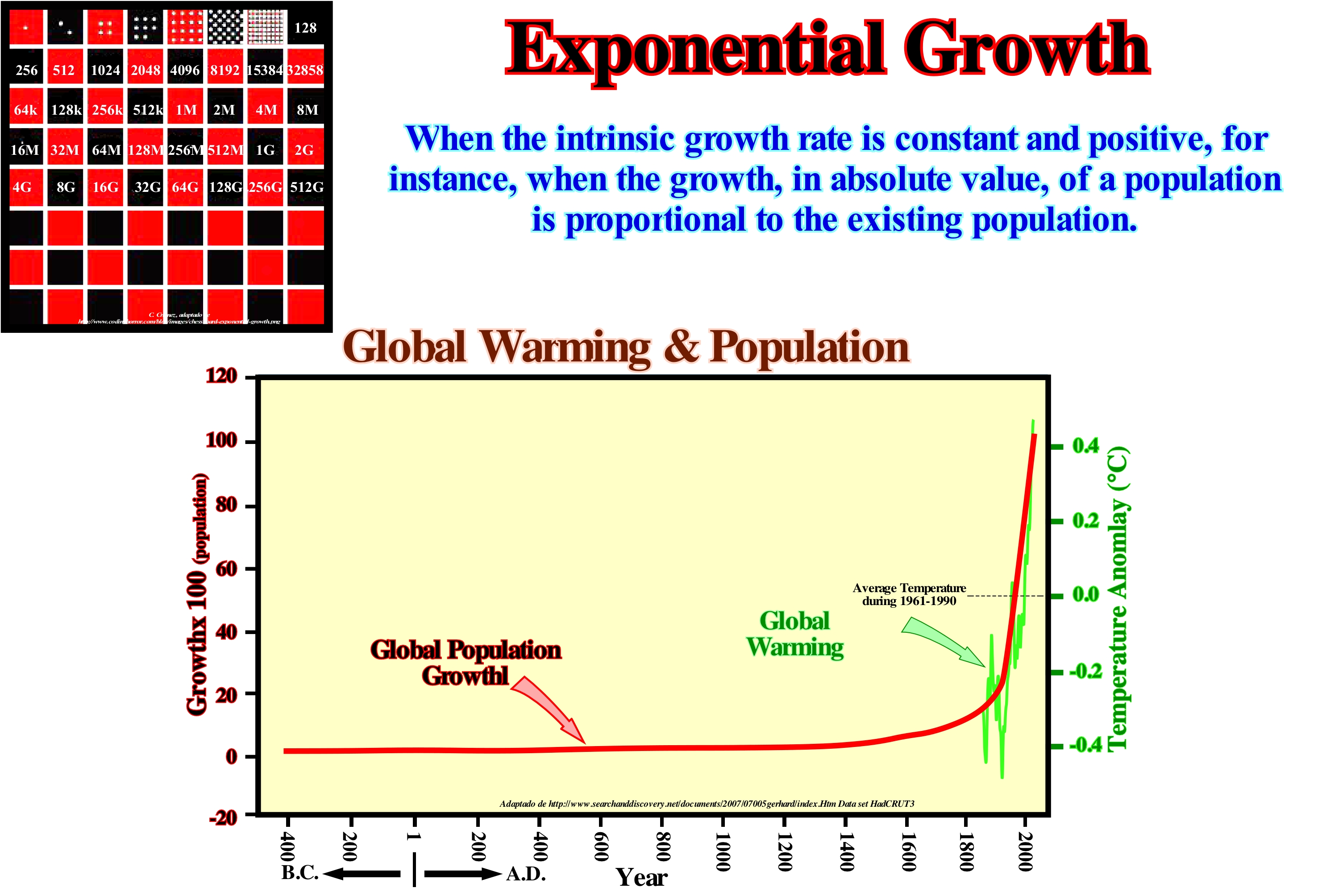
There is an ancient Persian legend about a very cultivated courtier who invented a game on a board with 32 white squares and 32 black ones (more or less the board of the current chess). When the courtier taught the king how to play, not only did he enjoy the board, but above all the way to play. The game actually translated into a battle between two kings, their courts, and their armies. To thank the courtier, the king told him: "You can ask me whatever you want." The courtier said to the king, put me a grain of rice in the first square of the board, two grains of rice in the second house, 4 grains in the third, and so on. The king, promptly, agreed, but he told him, why you want so little, when you gave me so much pleasure. Not so, majesty, have the beans placed and then we'll talk. In fact, in the fortieth square of the board (do not forget that the board has 64 squares, that is, 32 white and 32 black), one million million grains of rice had to be brought from the real collections. And so all the rice reserves of the kingdom were exhausted before reaching the 64th house. All this means that an exponential growth or increase is very deceptive because it generates an immense amount very quickly. By the time it fills the thirty-second square of the trays, the number of rice grains is, already, a huge number. In the same way, if any population has a constant birth rate over time and is never limited by lack of food or disease, it has an exponential growth. With an exponential growth, the birth rate only controls the rate at which the population grows. Imagine two fish, a birth rate of 1.5 and a minute (time) for each generation. At the end of 10 generations there are 115 and at the end of 20 generations there are 6,650 fish. The exponential growth is, totally, unrealistic. It does not consider the environmental limits that have important consequences on the population. In an exponential growth, a population can grow without limits. Logistics growth is more realistic. He considers environmental limits, such as density, abundance of food, disease, parasites, competition, etc. In logistic growth, a population has a limit due to environmental factors. In exponential growth, the per capita growth rate of a population (per individual) remains the same regardless of population size, causing the population to grow, more and more, rapidly as it increases. In nature, populations can grow exponentially over a period of time, but then they are limited by the availability of resources. In logistic growth, the per capita growth rate of a population is declining as the size of the population approaches a maximum imposed by limited resources on the environment (carrying capacity). In a graph, exponential growth produces a J-shaped or golf-club shaped curve (as illustrated above in Global Population Growth), while logistic growth produces an S-shaped curve (such as growth of a trout population in a trout vivarium *)
(*) At first when there are few trouts and many resources, growth is exponential. Since the number of trout is large enough, the resources begin to run out. The rate of growth slows down. Over time, the population size becomes, more or less, constant which is translated by a S-shaped graph.