
Vaalbara (Supercontinent)............................................................................................................................................................................................Vaalbara
Vaalbara (supercontinente) / Vaalbara (supercontinente) / Vaalbara (Superkontinent) /瓦尔巴拉(超大陆名)/ Ваальбара (суперконтинент) / Vaalbara (supercontinente) /
The first supercontinent that the geoscientists could reconstruct. It was formed from protocontinentes that agglutinated about 3.1 Ga. The supercontinent Vaalbara fractured around 2.8 Ma.
See: « Supercontinent »
Valais Sea...................................................................................................................................................................................................................................................Mer du Valais
Mar do Valais / Mar do Valais / Sea Wallis / 海瓦莱 / Море Вале / Mare di Vallese /
A narrow sea or lake that formed when the Iberian microcontinent separated from Europe, during the first phase of Pangea (formation of Tethys Sea and the central Atlantic Ocean, between Europe, still associated with America and Africa).
See: « Microcontinente »
Valley (Stream, water course).........................................................................................................................................................................Vallée (Cours d'eau)
Vallée (courante) / Valle (corriente) / Valley (Flüsse) / 流域(河流) / Долина (реки) / Valley (fiumi) /
Area between the top of the slopes on each side of the bed of a water-course.
See: « Unconformity »
&
« Fluvial »
&
« River »
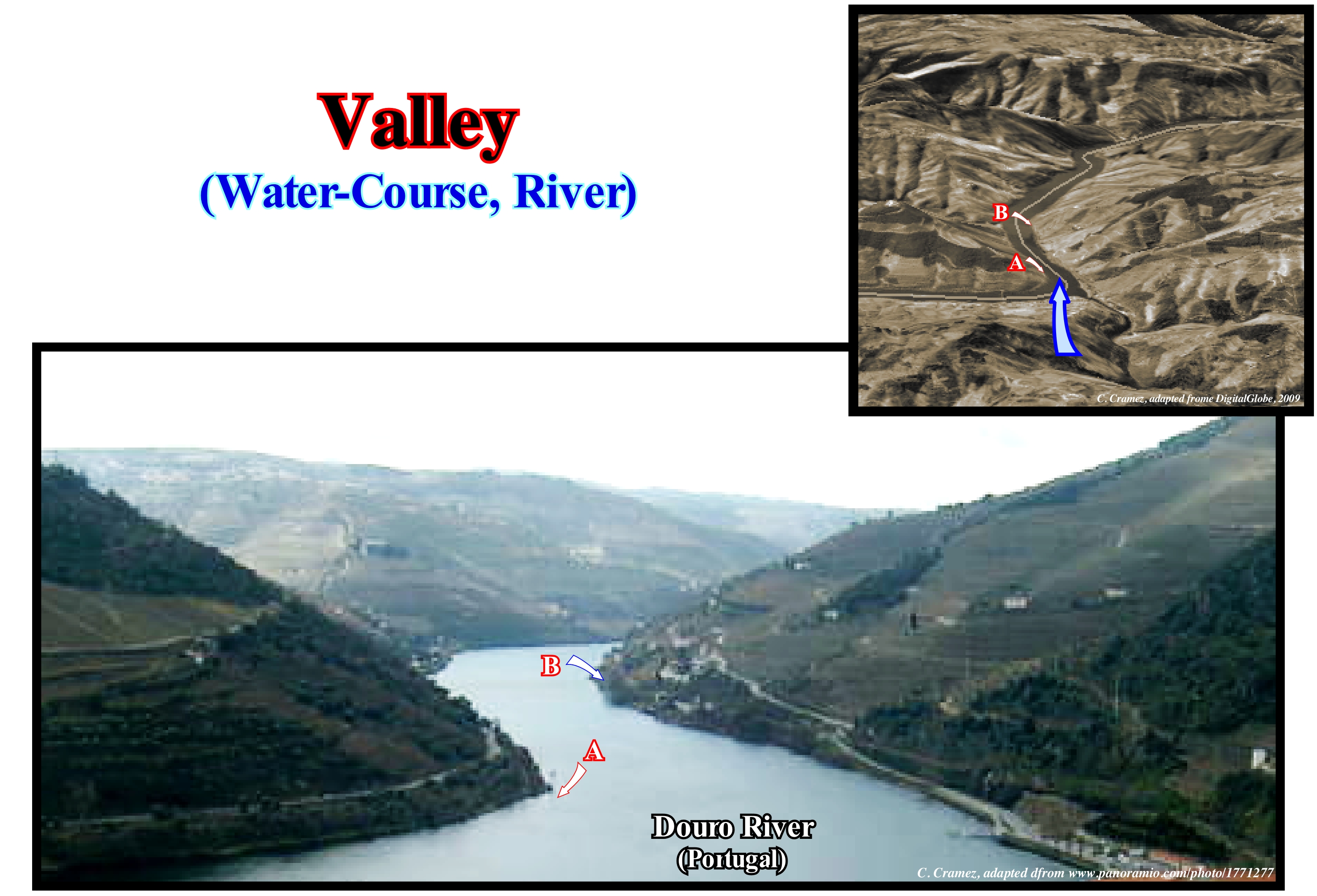
The valley of the Douro River, in Portugal, is known in all parts of the world, not only for its terraces (built largely by the Romans, as they did in the valley of the Rhone River, particularly in Switzerland), but above all because it is in them that grow grapes from which Porto wine is made. Never confuse the valley of a river with the river bed. The valley corresponds to the slopes that the populations use for the agriculture. The bed of a river is the space that can be occupied by the water-course. As this definition is very vague, it is interesting to know that a river, like any other water-course, may have at least three beds: (i) Greater Bed or Flooding Bed ; (ii) Ordinary Bed, or, rather, Apparent Bed and (iii) Reduced Bed. The grater bed encompasses all the zone that the river floods, which is covered, generally, with modern alluvium and which is much wider than the ordinary bed. The apparent bed (ordinary bed) is the bed, well determined between the margins, occupied by the materials rolled by the water and little disguised, unlike what happens with a larger bed, which is, largely, covered by vegetation and occupied by man. Reduced bed is the bed, which during the summer, occupies a small part of the normal bed and is not bounded by sharp margins (it wanders within the bounds of the ordinary bed and can, eventually, be divided into several arms). After the floods, the larger beds are occupied by fine sedimentary materials (except in the mountains), since the slopes, which are, generally, cultivated, provide, exclusively, fine grained sedimentary particles. This material constitute what geoscientists call overbanking deposits. The width of the ordinary or apparent beds depends on the strength of the rocks, the flow of the current and the obstruction of the materials transported. At a similar rate, the width of the apparent bed is maximal for streams loaded with sand, coarse sand, pebbles, and when the stream is formed of braided channels that circulate between the sedimentary banks. The material forming the bed of a water-course may be formed by rocks, in situ, or by materials carried by the current. It is abusive to associate the alluvial bed of a river with a fill and a rocky bed with erosion.
Variation (Statistics)...............................................................................................................................................................................Variation (Statistique)
Variação / Variación (desigualdad de Koksma) / Variation (statistische) / 变异(统计) / Изменение (статистика) / Variazione (statistica) /
In statistics, variation or coefficient of variation is a measure of dispersion that serves to compare different distributions. The standard deviation*, which is a measure of dispersion, is relative to the mean. It is defined as the ratio of the standard deviation to the mean. Since two distributions may have different mean values, the deviation of these distributions is not comparable. The solution is to use the coefficient of variation, which is equal to the standard deviation divided by the mean.
See: « Eustatic Sea Level Curve »
&
« Milankovitch's Curve »
&
« Reserves »
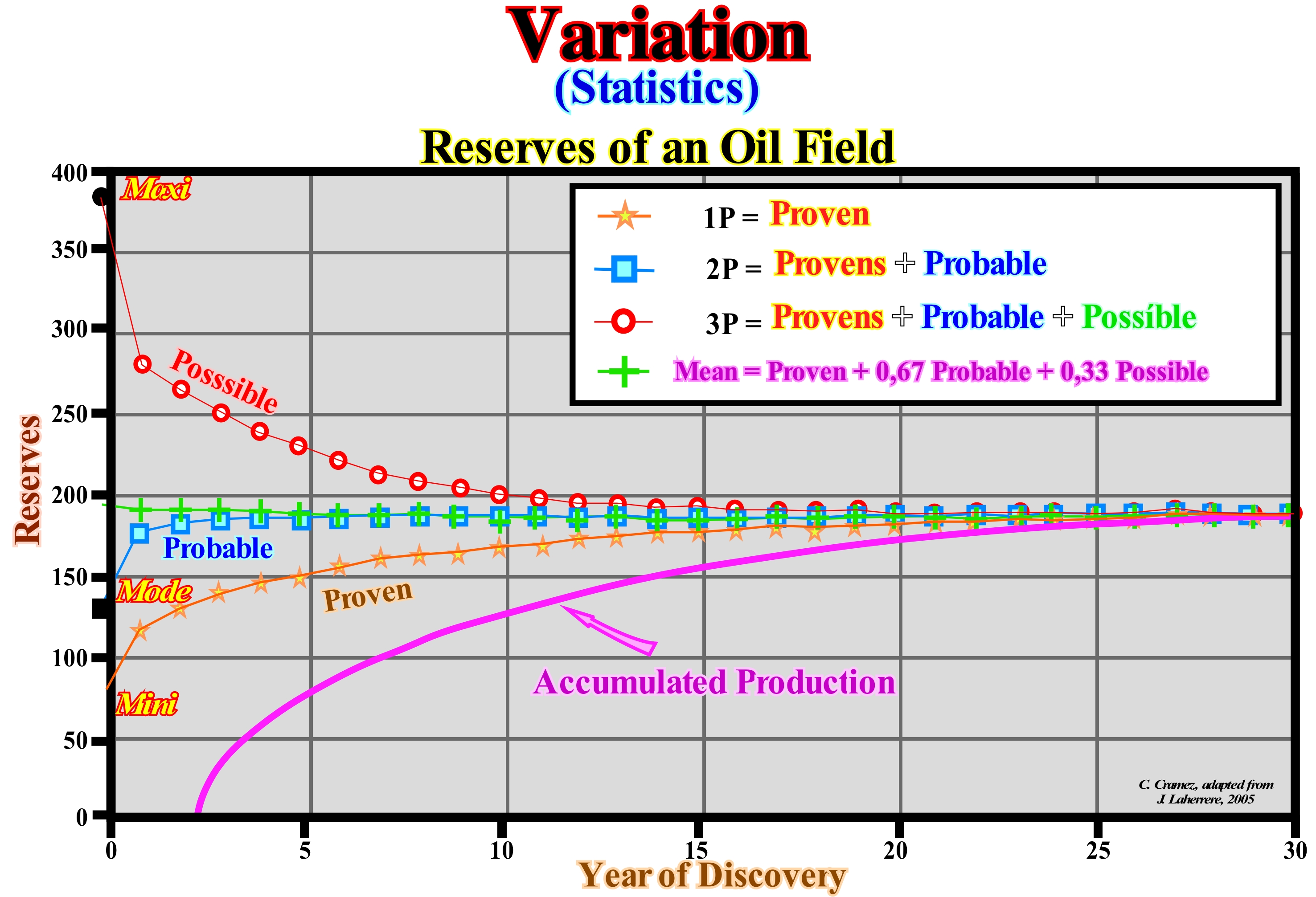
The coefficient of variation is, sometimes, multiplied by 100, i.e., expressed as a percentage. The coefficient of variation is recommended for quantitative variables of the type ratio (in which there is an absolute zero), such as height, weight and velocity. If the variable is not of the ratio type, the coefficient of variation may assume negative values and its interpretation will depend on the reference point (point considered as "0" in the scale), leading to misinterpretations and relative errors. Example: Consider a distribution with mean/average value equal to 40 and a standard deviation equal to 4. Then consider another distribution with mean/ average value equal to 5 and a standard deviation equal to 4. The standard deviation in the second distribution has a much more significant weight than in the first and yet this is the same in both. When determining the coefficient of variation it is possible to know how the standard deviation is for the mean/average value. In these examples, the coefficient of variation is respectively 4/40 = 0.1 and 4/5 = 0.8. When interpreting these values, it can be affirmed that, in the first distribution, on average, the deviations from the average reach 10% of the value of the latter. In the second distribution, the deviations from the average amount, on average, 80% of the value of the latter. The percentages show the weight of the standard deviation on the distribution. As illustrated in this figure, during the production of an oilfield, the variation of the hydrocarbon reserves, i.e., the uncertainty of the reserves varies with time. At the beginning of production the maxi, mode** and mini values are very different. However, as the hydrocarbons are produced, the maxi, mode and mini approach each other until they coincide with a certain real value that corresponds to the total of the hydrocarbons produced until the field is considered to be depleted.
(*) is a measure used to quantify the amount of variation or dispersion of a set of data values. A low standard deviation indicates that the data points tend to be close to the mean (also called the expected value) of the set, while a high standard deviation indicates that the data points are spread out over a wider range of values.
(**) The mode of a set of data values is the value that appears most often. The mode of the sample [1, 3, 6, 6, 6, 6, 7, 7, 12, 12, 17] is 6. Given the list of data [1, 1, 2, 4, 4] the mode is not unique – the dataset may be said to be bimodal, while a set with more than two modes may be described as multimodal.
Varve.......................................................................................................................................................................................................................................................................................Varve
Varva / Varva / Warve / 纹层 / Сезонная слоистость ила (варва) / Varva /
A pair of sedimentary units formed annually during seasonal climate changes. Normally, the varves are found in lacustrine glacial deposits. The sedimentary unit deposited during the summer has a light color and granulometry, relatively coarse. The unit deposited during the winter, under the ice layer, is of dark color and the grains that compose it are much thinner. The varves and the pollen that they contain are used to interpret the history of recent climate.
See : « Glacier »
&
« Glacio-Eustasy »
&
« Proglacial Lake »
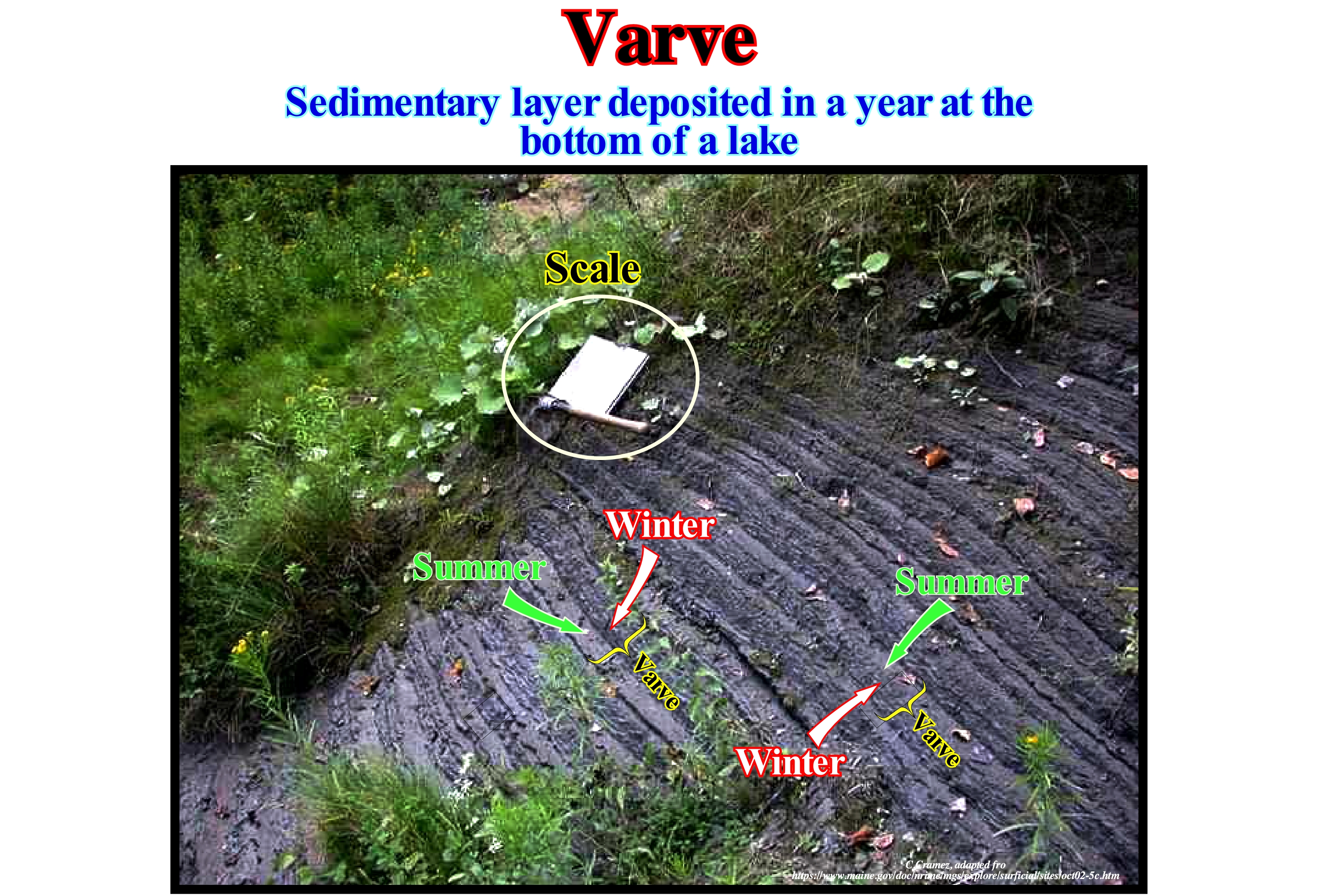
According to Wikipedia (https://en.wikipedia.org/wiki/Varve), the classic varve archetype is a light/dark coloured couplet deposited in a glacial lake. The light layer usually comprises a coarser lamina set, a group of conformable laminae, consisting of silt and fine sand deposited under higher energy conditions when meltwater introduces sediment load into the lake water. During winter months, when meltwater and associated suspended sediment input is reduced, and often when the lake surface freezes, fine clay-size sediment is deposited forming a dark coloured lamina set. In this photograph the sedimentation rhythm of lacustrine glacial deposits is, extremely, easy to recognize. Each pair of strata forms a varve and represents the accumulation over a year. The thicker layer deposits during the summer and the thinner during the winter. Sometimes and, especially, in the layers deposited during the summer, we find pebbles, that fell of the melting ice. In general, the layers deposited during the summer are lighter in colour and, sometimes, thinning upward. The layers deposited during the winter are less thick and darker, due to the clay minerals or organic material that is deposited slowly, by decantation (when the streams and the lakes are partially icy). Varves are, widely, used to study geochronology. They can be counted to determine the absolute age of some Pleistocene rocks of glacial origin. Of all the rhythmic rocks, that is to say, the rocks composed of alternating laminations of siltstones and shales, which reflect a seasonal sedimentation, the varves are some of the most important. The varves, which represent the smallest events recognized in the stratigraphy, contribute to understanding the climate changes of the past. A number of rhythmic rocks, which some geoscientists call rhythmites, the annual cyclicity, unlike that of the varves, is not proven. Another example of sedimentary cyclicity is tidal rhythmic, which in most cases (in ancient deposits) are combined with rhythms induced by glacial, eustatic fluctuations and fluctuations in the oxygen content of the oceans.
Vergence.......................................................................................................................................................................................................................................................Vergence
Vergência / Vergencia / Vergenz / 朝向 / Обратная величина фокусного расстояния / Vergenza /
Quality of what has opposite meanings, as for instance, faults, progradations, etc. Sometimes synonymous with Polarity.
See: « Seismostratigrafphy »
&
« Depositional Dip »
&
« Uplift (tectonic) »
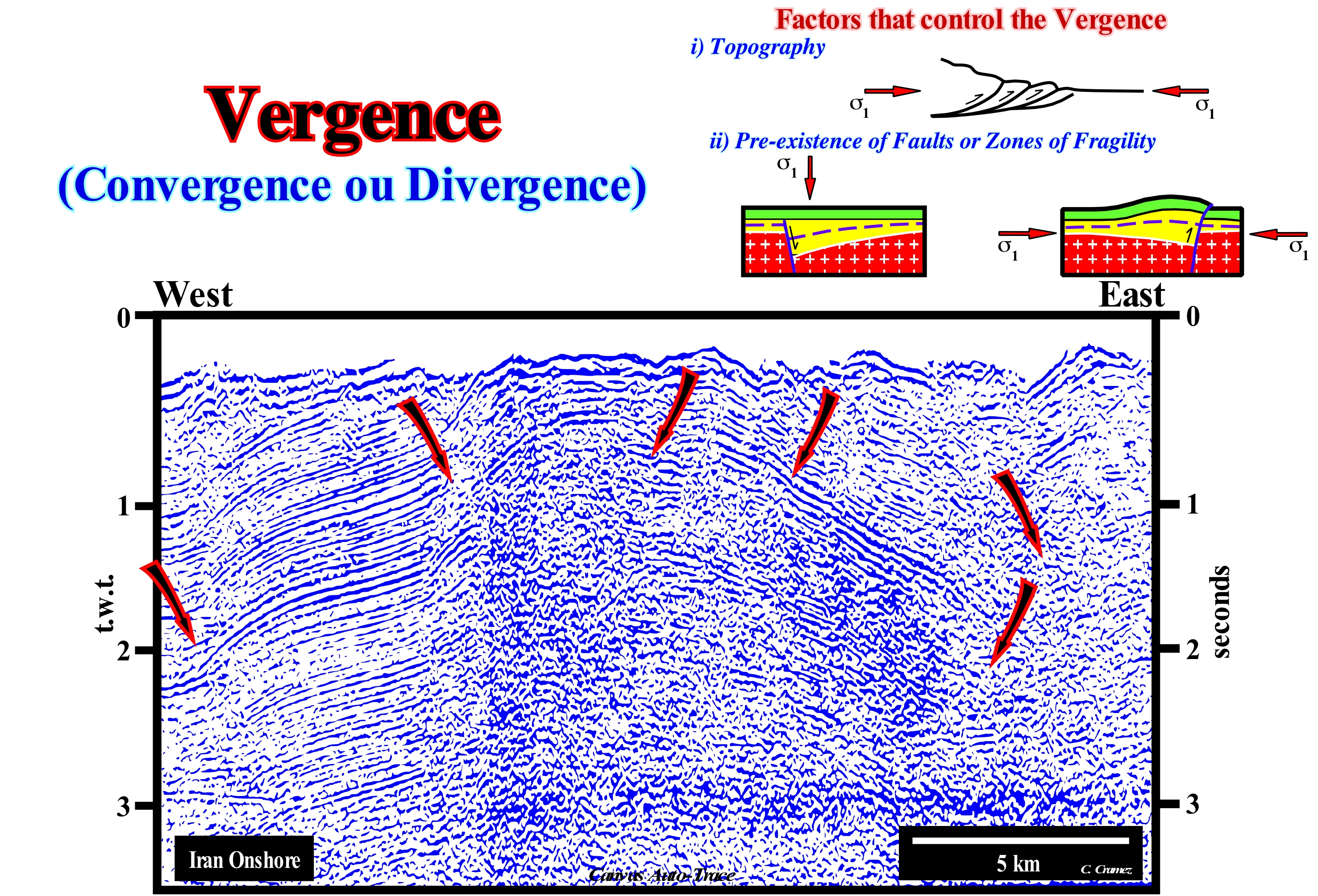
The importance of the vergence or polarity of geological objects is well illustrated on this Canvas auto-trace of a seismic line from Iran onshore. In the past, this auto-trace of an unmigrated seismic line has been interpreted in very different ways, especially, by interpreters with little geological knowledge, which was the case of the vast majority of geophysicists when I began my professional career in the "Compagnie Française des Pétroles," which is now called "Total SA". As can be seen, the continuity of the reflectors is interrupted several times, which means that there are different faulted blocks* separated by fault planes (mechanical discontinuities between the reflectors of the faulted blocks) that are not, generally, underlined by reflectors except for fault planes injected by salt, volcanism or when the interface is between rocks with very different acoustic impedances. The geoscientists in charge of the tentative geological interpretations of the seismic lines with little knowledge in geology always tend to interpret the faults as normal faults, especially, when the seismic data are not migrated, when the dip of the fault plane is towards hangingwall (lowered fault block). However, this is true, only, if the reflectors of the faulted blocks are horizontal, which is not the case, for example, in this auto-trace. Fortunately, in geology, there are rules that geoscientists have to respect. The vast majority of geoscientists know, perfectly, well that if the vergence of a fault plane (dip) is towards the hangingwall and that if it was raised (relative to the lower block), the fault is reverse, which means the sediments were shortened by a compressional tectonic regime characterized by an oblong ellipsoid of the effective stresses (geostatic pressure σg plus hydrostatic pressure or pores σp plus tectonic vector σt). In this case the σ1, i.e., the largest axis of the ellipsoid is horizontal and σ2 (middle axis) is, also horizontal, and parallel to the fault plane. If, on the contrary, the vergence of a fault plane (dip) is towards the hangingwall that was was lowered (relatively to the footwall), the fault is normal, which means that the sediments were lengthened by a tectonic extensional regime (σ1 is vertical and σ2 horizontal and parallel to the fault plane). It is important do not to forget that the sediments, in the same place and at the same time, are either lengthened or shortened, but not both at the same time. In other words, if on a seismic line, in association with the same structure, for example, in association with an anticline, there are reverse and normal faults, they are, certainly, of different ages and, probably, the normal faults are more recent, otherwise, they would have been, more or less, reactivated as reverse faults during the compressional tectonic regime responsible for the formation of the anticline. On this auto-trace, the first thing the geoscientists have to recognize is whether the sediments have been lengthened or shortened, which, theoretically, entails completely, different geological histories: (i) If the sediments were shortened (σ1 horizontal), there was ➞ Relative sea level fall (marine regression) ➞ Decreased accommodation (available space for sediments) ➞ Erosion and Unconformity ➞ New stratigraphic cycle ; (ii) If the sediments have been lengthened (σ1 vertical), there was ➞ Subsidence ➞ Relative sea level rise (marine ingression) ➞ Increasing or creation of available space for sediments ➞ Deposition. As in this example, the sediments were, clearly, shortened and uplifted (there is no evidence of lengthening), the predominant tectonic regime (post-deposition) was, certainly, compressional (σ1 horizontal) and, therefore, all faults (reactivated or no) should be interpreted as reverse, i.e., the vergence of the fault planes is toward the hangingwall (upper fault blocks) that were raised. Recall that: a) The fault plane is a fracture surface ; b) The direction of a fault is the line of intersection of the fault plane with a horizontal plane ; c) The dip of a fault is the angle defined between the fault plane and a horizontal surface ; d) Slip is the relative movement of geological features present on either side of a fault plane (a fault's sense of slip is defined as the relative motion of the rock on each side of the fault with respect to the other side ; e) The throw of the fault is the vertical component of the separation ; f) The heave of the fault is the horizontal component ("Throw up and heave out") ; g) The hangingwall is the block above the fault plane and h) The footwall is the block below the fault plane.
(*) A fault is a fracture or fractured zone along which displacement can range from a few centimeters to kilometers, which is characterized by a fault line, fault plane and throw. The walls of faulted blocks in the field are, normally, striated and polished (fault mirror), a result of the movements of the blocks. The thickness of a fault can range from a few millimeters to tens or hundreds of meters.
Vernal (Point)............................................................................................................................................................................................................................Vernal (Point)
Vernal (ponto) / Vernal (punto) / Frühlingspunkt / 春分点 / Точка весеннего равноденствия / Punto vernale /
Point on the celestial sphere where the Sun is located at the spring equinox (vernal). The northern hemisphere is taken as a reference for the seasons.
See: « Orbit »
&
« Equinox »
&
« Milankovitch's Cycle »
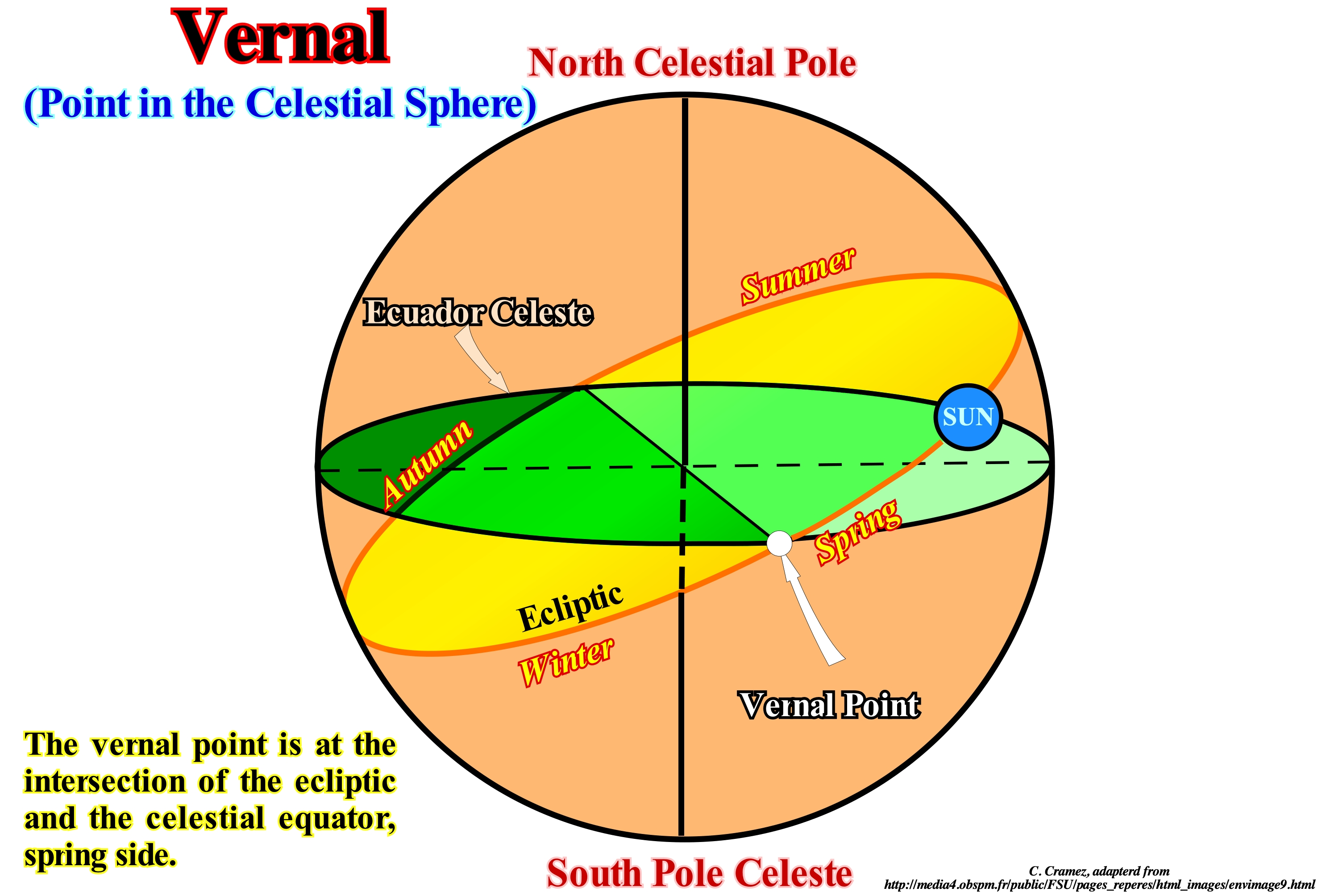
As illustrated in this scheme, in the celestial sphere, the equator and the ecliptic intersect. The two intersections are called nodes. During its apparent movement, the Sun crosses these two points, one passing from the Northern Hemisphere to the Southern Hemisphere, the so - called descending node, and the other passing from the Southern Hemisphere to the Northern Hemisphere - ascending node. It is this last node (ascending node), which is called the vernal point or sometimes the point of the spring equinox. In the equatorial coordinate system the axes or references are: (i) The meridian passing through the spring equinox, which defines the zero meridian to measure right ascension* and (ii) The celestial equator from which the declination is measured (positive to above the equator and negative to below). It can be said the coordinates of the vernal point are: (a) Right ascension zero 0 h (since it is situated at zero meridian) and (b) Declination is zero because, as shown above, the vernal point is located on the celestial equator. In conclusion, the vernal equinox, which is defined by the intersection of the celestial equator and the ecliptic, changes position with the precession and nutation** movement of the axis of rotation of the Earth. Because of the movement of the vernal equinox, it is its coordinates on January 1, 2000, at noon, which serve as a reference for the equatorial coordinate system. Just as the longitude of a place underlines the angle between the meridian of the place and a reference meridian, the right ascension of a star underlines the angle between the star's hourly circle and a reference hour circle. In the same way that the Greenwich meridian and the equator serve as reference points for terrestrial longitude, the vernal point serves as a reference for the right ascension (azimuthal coordinate of the equatorial coordinate system that equals the arc, measured in the celestial equator, between the hourly circles that pass through the vernal point and the star, respectively, counter-clockwise when viewed from the celestial north pole). Right ascension is always measured as an angle expressed in hours, minutes and seconds of sidereal time, where one hour equals, more or less, the equivalent of 15 degrees.
(*) Angular distance of a particular point measured eastward along th celestial equator from the Sun at th March equinox to the (hour circle of the) point above the earth in question (https://en.wikipedia.org/wiki/Right_ascension)
(**) Astronomical nutation is a phenomenon which causes the orientation of the axis of rotation of a spinning astronomical object to vary over time. It is caused by the gravitational forces of other nearby bodies acting upon the spinning object.
Vernal Point..................................................................................................................................................................................................................Point Vernal
Ponto vernal / Punto vernal / Frühlingspunkt / 春分点 / Точка весеннего равноденствия / Punto vernale /
One of the two points where the celestial sphere or the celestial equator intersects the ecliptic, in particular, the point defined by the position of the Sun on the celestial sphere at the moment of the March equinox (spring in the northern hemisphere). The vernal point, also known as Aries Point, is opposite to Libra Point.
See: « Equinox »
&
« Libra Point (astronomy) »
&
« Equinoxial Precession »
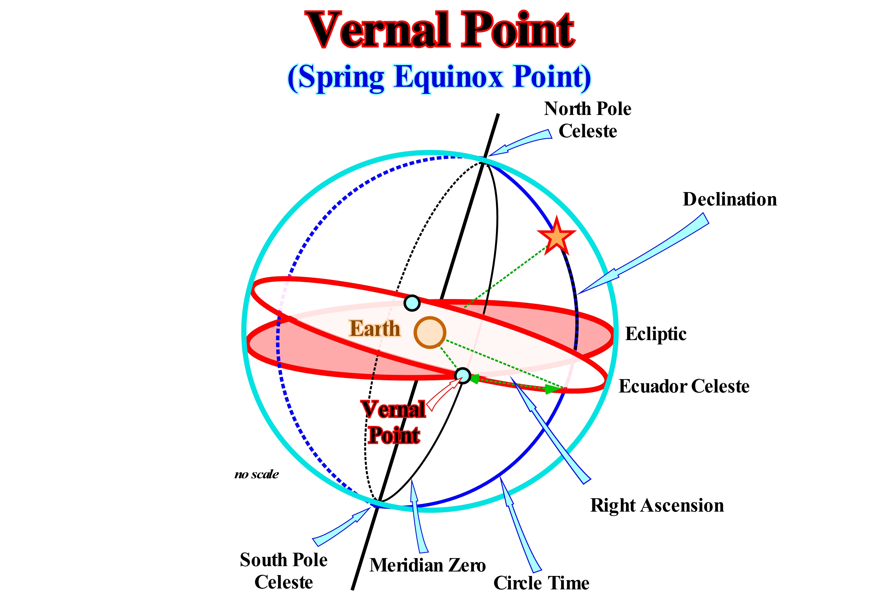
In the celestial sphere, the equator and ecliptic cross. The two points of intersection are called nodes. During its apparent movement, the Sun crosses these two points, one when it passes from the northern hemisphere to the southern hemisphere. This descending node is called the Libra point. The other point is when the Sun passes from the southern hemisphere to the northern hemisphere, i.e., the ascending node which is called Aries point or vernal point. The Libra point marks the autumnal equinox and the vernal point underlines the spring equinox. As shown in this schematic, the Equatorial Coordinate System* reference, also called the Universal Equatorial System or Uranographic System, are firstly the meridian passing through the spring equinox (vernal point), and which defines the zero meridian to measure right ascension and, secondly, the celestial equator from which the declination is measured (positive above the equator, negative below). Thus, the coordinates of the vernal point are: (i) Right ascension is zero hours, since it is located on the zero meridian ; (ii) Zero declination, since it is located on the celestial equator ; (iii) Polar distance 90°, since the polar and complementary distance of the declination, i.e., the sum of the two is 90°. Naturally due to the precession of the equinoxes (change of the axis of rotation of an object), the vernal point moves, slowly, along the ecliptic. At present-time, the vernal point is located in the Pisces constellation, where it entered about 60 BC (before Christ) and will leave about 2,600 to enter the Aquarius constellation. When the Earth is up in the celestial equator, in the northern hemisphere the duration of the day is greater than the night, since the Earth is inclined on its axis in relation to the Sun. As the Earth also orbits the Sun, in the equinoxes, this is at the Libra point and Aries point, the Earth and the Sun are positioned in such a way that the line on Earth that separates night from the day passes through both poles of the Earth, the night has the same duration as the day.
(*) Celestial coordinate system widely used to specify the positions of celestial objects. It may be implemented in spherical or rectangular coordinates, both defined by an origin at the centre of Earth , a fundamental plane consisting of the projection of Earth's equator onto the celestial sphere (forming the celestial equator), a primary direction towards the vernal equinox , and a right-handed convention. In this coordinate system the values are independent of the position of the observer. This system uses as a reference plane the projection, on the celestial sphere, of the equator of the Earth. This projection is the celestial equator, which divides the sky into two hemispheres, each having as a reference axis the projection of a terrestrial pole, perpendicular to the celestial equator. From these divisions, the system makes it possible to establish two angular coordinates: right ascension and declination. (https://fr.wikipedia.org/wiki/Système_de_coordonnées_équatoriales)
Vertical Accretion Deposit....................................................................................................Dépôt d'accrétion verticale
Depósito de acreção lateral / Depósito de acreción vertical / Vertikale Akkretion Ablagerung / 垂直冲积层沉积 / Вертикальное наращение / Deposito di accrescimento verticale /
Deposit that accumulates in the flooding plain when rivers overflow the natural levees bordering the channels. Vertical accretion or floodplain deposits occur when rivers leave the beds, where they, normally, flow, during flood seasons and deposit sediments on the surface of flood plains, increasing the altitude of these surfaces.
See: « Flood-Plain Deposit »
Vertical Sedimentation.............................................................................................................................Sédimentation verticale
Sedimentação vertical / Sedimentación vertical / Vertikale Sedimentation / 垂直沉积 / Вертикальная седиментация / Sedimentazione verticale /
Vertical accumulation on depositional surface, of significant dimensions, resulting from a stacking of sedimentary particles transported vertically. Generally, the aggradation results from the deposition of sedimentary particles coming from upstream of the current that transport them.
See: « Sediment Supply »
&
« Deposition Model (sand-shale) »
&
« Relative Sea Level Change »
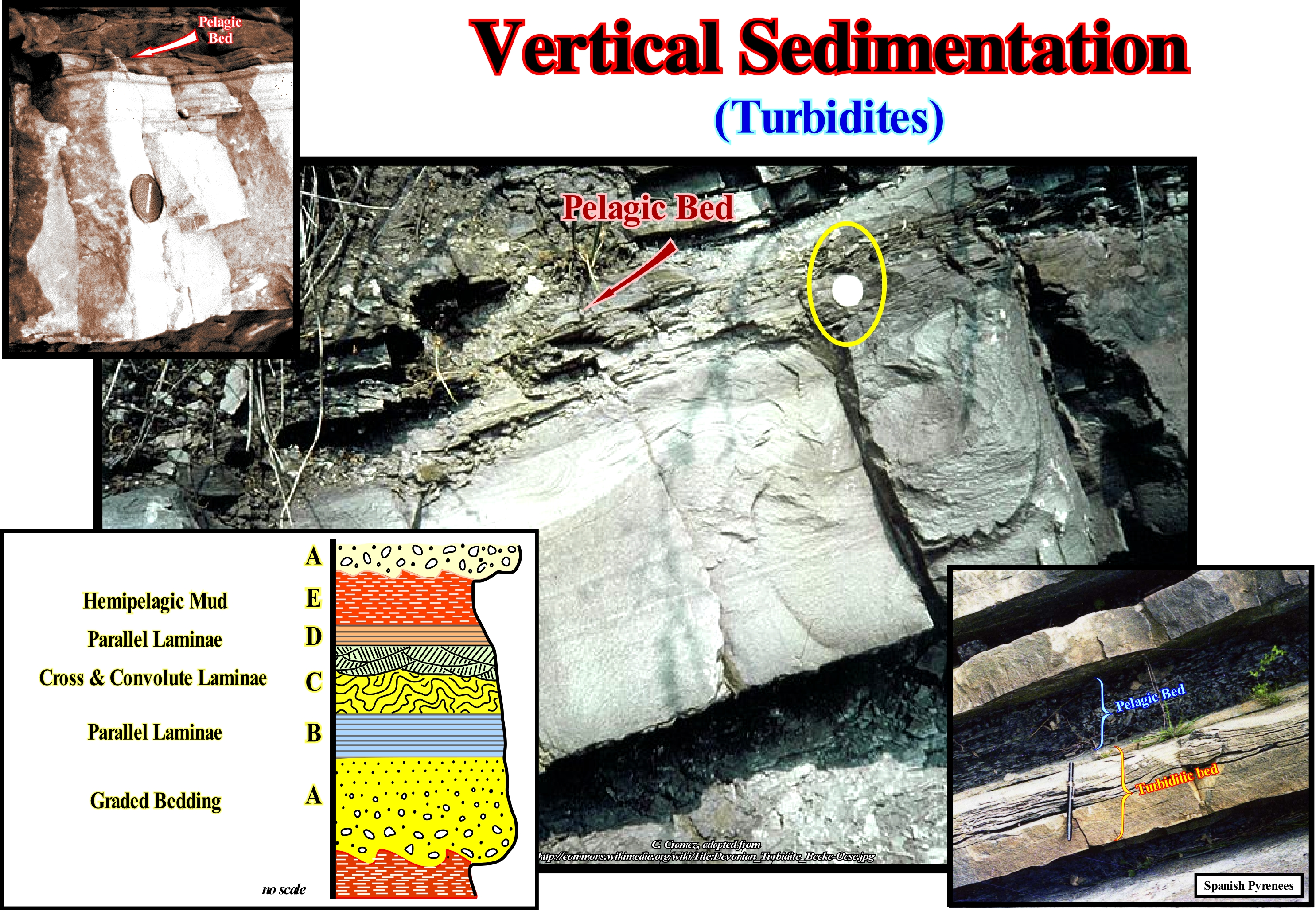
In this figure, sedimentary intervals associated with two completely different types of sedimentation are illustrated: (i) Near-instantaneous (geologically) sedimentation of particles transported by turbidity (or turbidite) currents and (ii) A much longer sedimentation (a few centimeters for several hundred or thousands of years) of particles falling vertically to the bottom of the sea. The first type of sedimentation is represented by the lower intervals of a turbidite bed, while the second is represented by a pelagic interval, which fossilizes the turbidite bed, although some geoscientists consider it to be part of the turbidite bed, which do not have too much sense. Bouma considers five layers in a complete turbidite interval. From bottom to top, Bouma distinguishes: (A) A massive or graded bed layer (finning upward) ; (B) A layer with parallel sandy laminae* ; (C) A layer with corrugated or convoluted laminae ; (D) A layer interval with fine parallel laminae of silt and mud, and finally (E) A layer consisting of hemipelagic mud, at the base of which a little sludge may be found coming from the turbiditic current. Irrespective of whether or not the pelagic interval (E) is considered to be part of the turbidite bed (A, B, C, D), at least three things differentiate the interval (E) from the other intervals: (1) A sedimentation rate extremely slow ; (2) The layers A, B, C, D settle, generally, within a few hours, while the pelagic interval may take thousands of years to deposit ; (3) Sedimentation is vertical, i.e., the sedimentary particles that form it fall, slowly, through the water-column, which contrasts strongly with the deposition of the particles of the layers A, B, C, and D, which is made by loss of competence, i.e., by deceleration of the turbidite current. The granulometry and fauna are criteria of differentiation. The sedimentary particles of the pelagic interval are finer and the fauna is more significant, since the fauna of the A, B, C and D layers is transported. In sequential stratigraphy the turbidite beds and the pelagic layers, deposited between turbidite beds, particularly those forming the submarine basin floor fans (the turbidite beds shown in this photograph belong to a submarine basin floor fans) are very important because they allow to date the unconformities or the correlative deep-water paraconformities, limiting the stratigraphic cycles and, especially, those that limit the sequence-cycles. In fact, they underline the minimum hiatus between two sequence-cycles or between two 3rd order eustatic cycles, which allow to date, with an error lower than 3/5 My years, the relative sea level fall responsible of the erosional surface that emphasizes the unconformity. As sedimentary clasts have, practically, all originated in the continent, the lateral sedimentation is, normally, predominant. Vertical sedimentation occurs, mainly, in carbonate depositional systems and in deep-water environments, where pelagic sedimentation is abundant or in low energy environments, as, for instant, in lacustrine environments. In the shelf and continental slope environments, sedimentation is, mainly, lateral, even if, globally, it is represented by a vertical accumulation of beds, which, individually, have a progradational internal configuration (sigmoid or oblique). This is particularly noticeable on the transgressive intervals of the sequence-cycles. Indeed, a transgressive interval, which many geoscientists call abusively, "transgressive systems tract" or "transgression," is the result of a set of single accelerating marine ingressions (eustatic paracycles), i.e., of the marine ingressions increasingly important and the associated sedimentary regressions (sequence-paracycles) that are increasingly less important, which, collectively, develops a sedimentary unit with a retrogradational geometry. Marine ingressions displace continentward the shoreline creating or increasing the available space for sediments, while sedimentary regressions, deposited during the stability period of relative sea level, occurring after each marine ingression, displace the shoreline seaward as the sedimentary systems tracts, with a lateral sedimentation, progradate seaward.
(*) In geology, laminae (plural of lamina) are, gewnerally, smaller and less pronounced than bedding. Lamination is often regarded as planar structures one centimetre or less in thickness, whereas bedding layers are greater than one centimetre. However, structures from several millimetres to many centimetres have been described as laminae. A single sedimentary rock can have both laminae and beds. (https://en.wikipedia.org/wiki/Lamination_(geology)
Vertical Seismic Resolution..........................................................................................Résolution sismique vertical
Resolução sísmica vertical / Resolución sísmica vertical / Vertikale seismische Auflösung / 垂直地震分辨率 / Поток взвешенных наносов / Risoluzione sismica verticale /
Seismic resolution corresponding to the minimum vertical distance between two interfaces, necessary for a simple reflection to be observed, on a seismic line. It is, mainly, controlled by the wavelength of the seismic signal*, which, rarely, is less than 50 m. As the thickness of an interval approaches a quarter wavelength, constructive interference produces an amplitude accumulation known as the tuning effect, which thickness is, generally, considered as the limit of resolution or separability.
See: « Horizon »
(*) Signal radiated from a seismic source,, which can be an explosion or a shear rupture. The seismic signal is, usually, a more or less complicated displacement step function or velocity impulse of finite duration from milliseconds up to a few minutes at the most. In seismic (reflection or refraction), as well as in seismology, one of the key problems is to solve the inverse problem ( process of calculating from a set of observations the causal factors that produced them), i.e., to derive from the analysis of seismic records information about the structure and physical properties of the Earth medium through which the seismic waves propagate as well as about the geometry, kinematics and dynamics of the seismic source process. This task is complicated by the fact that the seismic signals radiated by the source are weakened and distorted by geometric spreading and attenuation and, due to reflection, diffraction, mode conversion and interference during their travel through the Earth. They are also distorted by the transfer function of the seismograph. (http://gfzpublic.gfz-potsdam.de/pubman/item/escidoc:4017:4/component/escidoc:4018/Chapter_4_rev1.pdf)
Virus.........................................................................................................................................................................................................................................................................Virus
Vírus / Virus / Virus / 病毒 / Вирус / Virus /
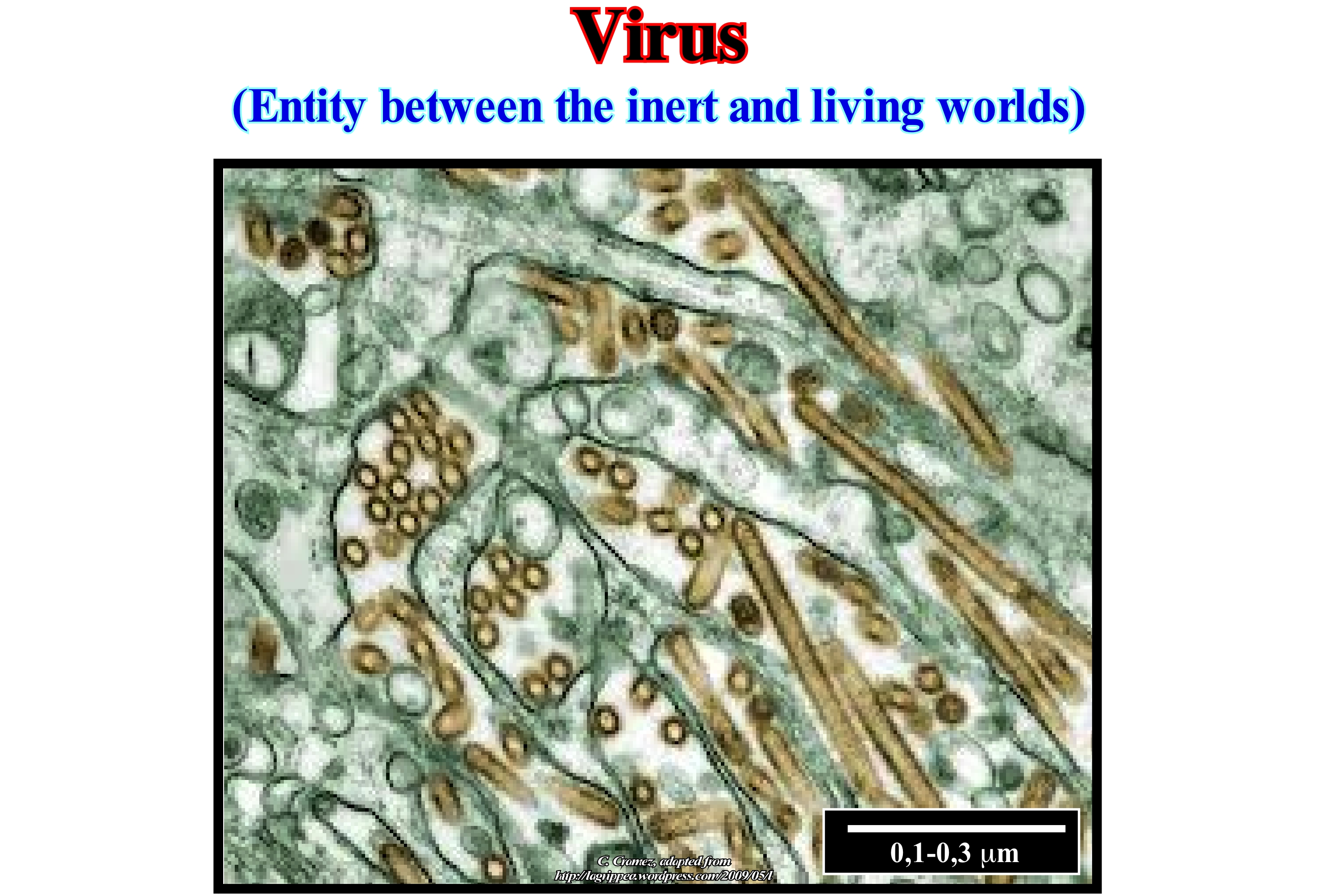
Nonliving organisms or cells. They are particles about 0.1/0.3 micrometers in diameter that contain a single or double genome of DNA or RNA. Viruses can reproduce only within living cells of bacteria, plants or animals.
See: « Life »
&
« Organic Matter (types) »
&
« Cyanobacteria »
Viruses differ from bacteria because they are much smaller, of non-cellular constitution and intracellular parasites. They are not able to grow in nonliving culture medium. There are viruses with specificity for various cell types, both eukaryotic and prokaryotic. The strict dependence of host cells is due to their inability of the virus to synthesize the necessary enzymes to the mechanisms of its propagation. By penetrating the cells, the viruses are able to use host enzymes to their own advantage. Viruses that parasitize bacteria, bacteriophage or simply phages are more, easily, manipulated, although their study requires the application of general techniques of microbiology, less time consuming due to the rapid growth rate of the bacteria used. When a bacteriophage infects a receptive bacteria one of two things will happen: (i) Bacteria's lysis (the process of rupturing or dissolving the plasma membrane or bacterial wall, which leads to cell death and the release of its contents) or ii) Bacteria lysogeny (the state of a bacteria in which it carries the DNA of an inactive virus, integrated into its genome). When lysis occurs the metabolism of the bacteria is reoriented towards the synthesis of the gnomic DNA of the virus and of the proteins to produce the mature phage particles. When the available cellular material is used, the cell bursts and releases the mature virions, capable of reinfecting new bacteria they encounter. The bacteriophages that cause bacterial lysis are called virulent or lytic (related to lysis). When the infection does not lead to the death of the bacteria, a relationship designated lysogeny is established between it and the virus and the phage is termed temperate or lysogenic. In these cases the phage DNA is integrated into the chromosome of the bacteria and it grows normally. Occasionally one of these bacteria enters the lithic cycle and releases virions capable of infecting other cells (http://shvoong.com/exact-sciences/biology/1767169-bacteriophages /). Retroviruses are a family of spherical viral particles (0.1 μm in diameter), which contain a genome formed by two identical RNA molecules.
Virus (Pelagic)......................................................................................................................................................................................................................Virus (Pélagique)
Vírus / Virus (pelágico) / Virus (pelagische) / 病毒(上层) / Вирус (пелагический) / Virus (pelagico) /
Viruses present in a pelagic system.
See: « Life »
&
« Víruses »
&
« Cyanobacteria »
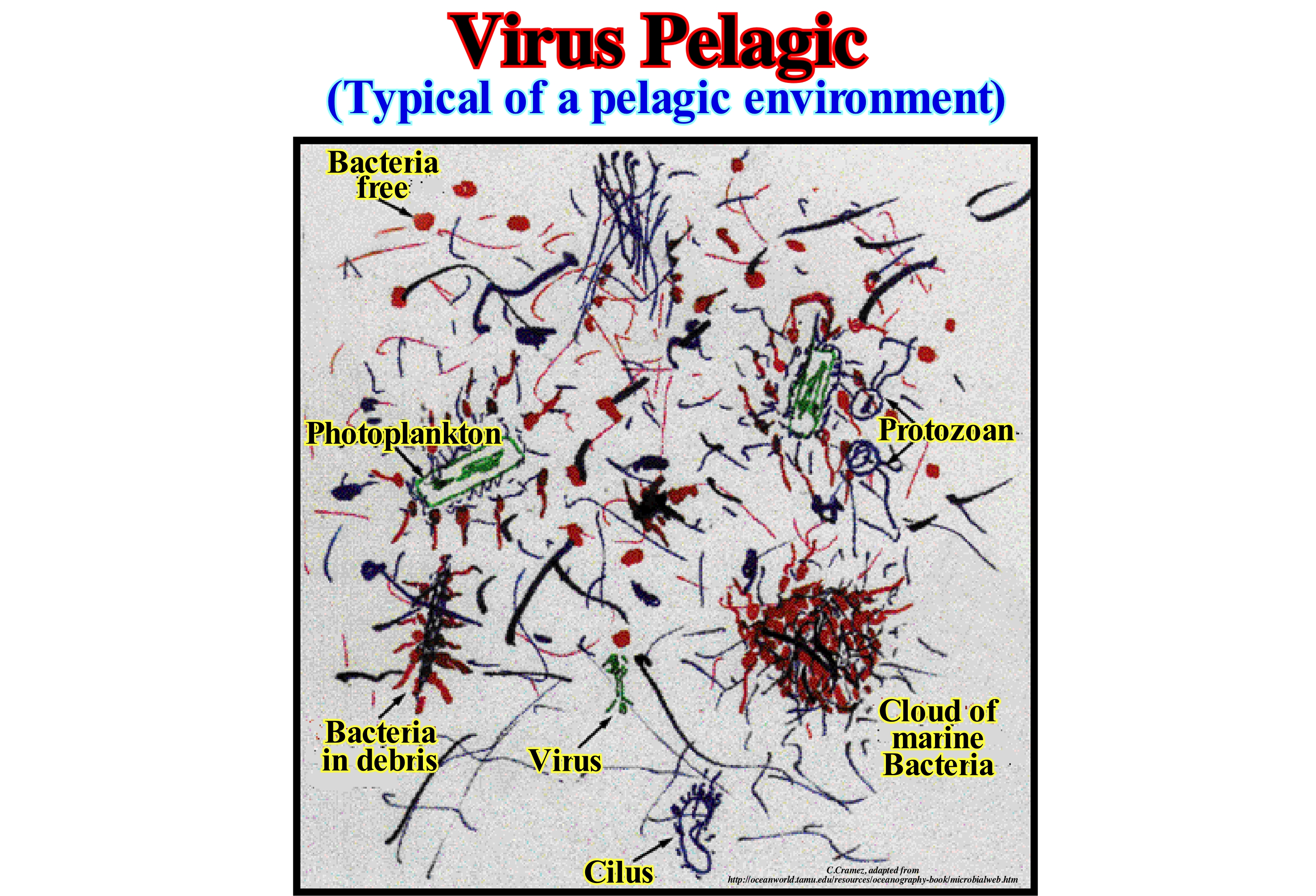
Viral lysis (the process of rupturing or dissolving the plasma membrane or bacterial wall, leading to cell death and the release of its contents) is a major cause of bacterial mortality in pelagic marine systems. Pelagic virus-induced mortality of bacteria has implications for the abundance and composition of bacterioplankton communities (bacteria that make up the plankton that drift into the water slide and occupy ecological niches in aquatic systems, many of which are saprophytic and derive their energy from the consuming the organic material produced by others and others are autotrophic and obtain their energy by photosynthesis or chemosynthesis, these forms belong to the picofitoplankton and include the bacteria of the genera Synechococcus and Prochlorococcus) and an important effect in the recycling of microbial nutrients. In addition to killing cells from the infected host, viral lysis causes the release of new virus from host cell contents, including cytoplasmic and structural material, into the environment. The material released by viral lysis may be a high quality viral substrate with a nitrogen and phosphorus content more important than that produced by photosynthesis. If there is an important food source for pelagic bacterioplankton, viral lysis influences the recycling of organic matter in the microbial food chain. Scientists demonstrate that the dissolved organic carbon released by viral lysis from a host bacterial population can be an important source stimulating the growth of uninfected bacterial populations. Consequently, viral activity tends to maintain heterotrophic production and respiration in the bacterial fraction and thus reduce the transfer of organic carbon to higher trophic levels. It is, generally, accepted that 10-30% of bacterioplankton production is lost every day as a result of viral infections, and thus, a significant fraction of the bacterial production can be released as dissolved organic matter. It is, likely, that bacterial production is to a large extent sustained by recycling of viral lysis and that a significant fraction of the total heterotrophic respiration of marine plankton is the result of recycling viral lysis of bacteria. (http://www.mbl.ku.dk/Middelboe/html/the_role.html).
Viscosity (Petroleum)...........................................................................................................................................................................................Viscosité (Huile)
Viscosidade (petróleo) / Viscosidad / Viskosität / 粘度(油) / Вязкость (нефть) / Viscosità (olio) /
Resistance to the flow of petroleum or gas. The viscosity of the gas is about 100 times smaller than the viscosity of the oil. A poor reservoir-rock for oil, i.e., a reservoir with a permeability that does not allow an economic petroleum production, may possibly be a good reservoir-rock for gas.
See: « Petroleum »
&
« Heavy Oil »
&
« Gas »
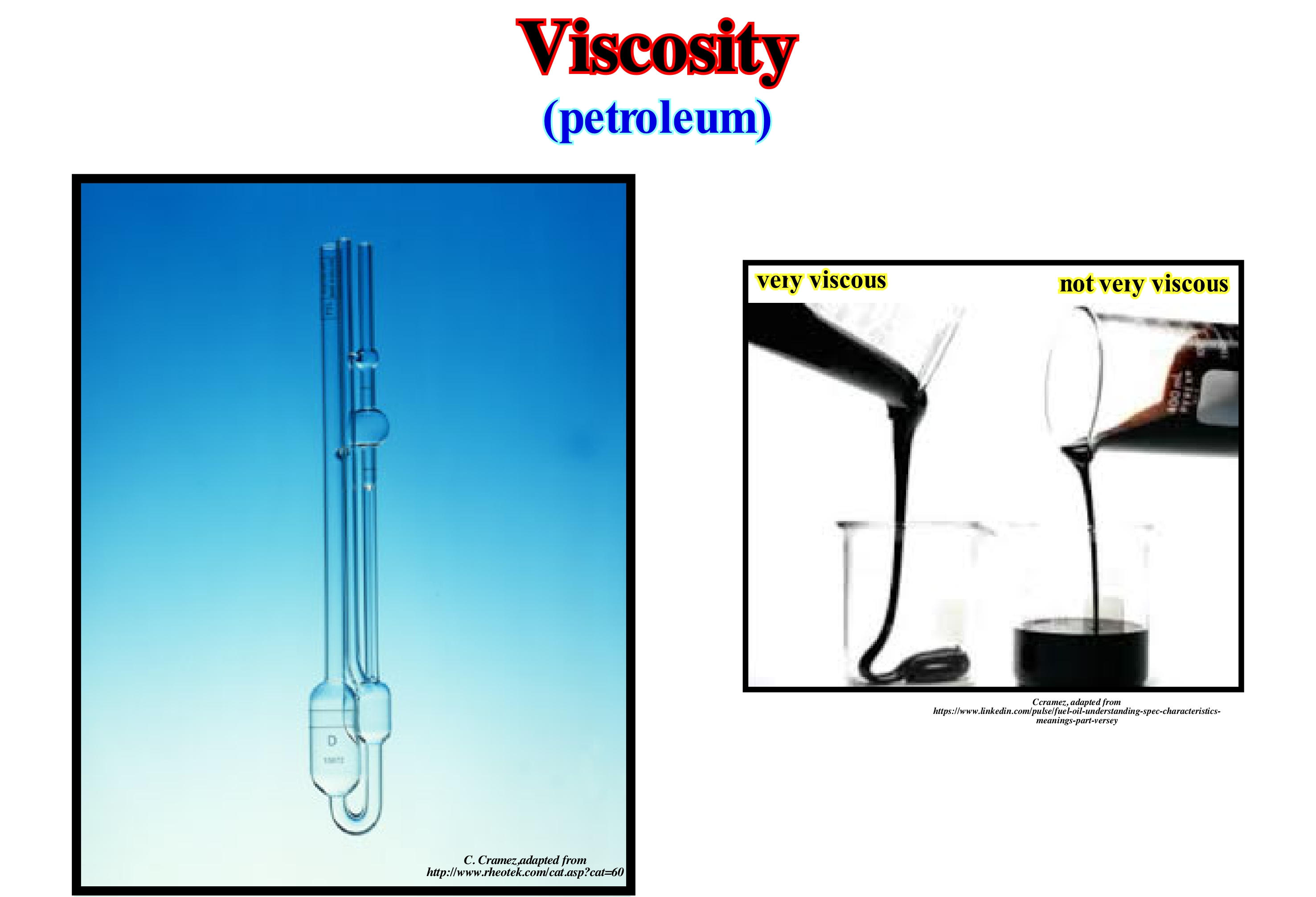
Viscosity is the resistance to flow of a fluid. Viscosity is the measure of the resistance of a fluid when it is deformed by a shear or extension. A high viscosity means that the fluid does not flow easily, such as honey. A small viscosity means that the fluid flows easily, such as water or gasoline*.In ordinary language, viscosity is, regularly, correlated with the thickness of a fluid. A liquid with low viscosity is a thick liquid, like Port wine. A fluid with high viscosity is a thick fluid with jelly or the magma of a volcano. A viscometer, as shown in this figure, is an apparatus used to measure the viscosity of fluids. There are two related measures of fluid viscosity: (i) Dynamic (or absolute) and (ii) Kinematic. Absolute viscosity is a measure of internal resistance ; it is the tangential force per unit area required to move one horizontal plane with respect to an other plane - at an unit velocity - when maintaining an unit distance apart in the fluid. Kinematic viscosity is the ratio of the absolute (or dynamic) viscosity to density, i.e, a quantity in which no force is involved. Kinematic viscosity can be obtained by dividing the absolute viscosity of a fluid with the fluid mass density. The units of dynamic viscosity, which is a fundamental property, are m.m2/s (meter squared per second) or m Pa.s (meter Pascal second). If a fluid having a viscosity of 1 pascal-second (Pas) is placed between two plates and one of which is pushed laterally by a shear stress of 1 Pa (pascal), it moves a distance equal to the thickness of the fluid in a second. In the system cgs (centimetre gram second), the physical unit of viscosity (dynamic) is the poise (P). The relation between poise and pascal-second is: 10P = 1 kg.m-1.s-1 = 1Pa.s. The relationship between the viscosity (dynamic) and the density of a fluid is the kinematic viscosity, whose unit is the stoke. Fluids with a constant viscosity are Newtonian fluids. Fluids with a variable viscosity are non-Newtonian fluids, for which viscosity can not be described by a simple number. The temperature has a very large influence on the viscosity of a fluid. When the temperature is low the viscosity increases. In winter, the engines of cars have difficulty catching, it is because the oil is more viscous. In certain products such as lubricating oil, diesel, bitumen, etc., the viscosity value is fundamental.
(*) A colorless petroleum-derived flammable liquid that is used primarily as a fuel in spark-ignited internal combustion. (https://en.wikipedia.org/wiki/Gasoline)
Visor Cliff...............................................................................................................................................................................Falaise à viseur et encoche
Arriba com visor / Acantilado con visera, Voladizio / Visierklif / 遮阳悬崖 / Скала, выступающая в виде козырька / Scogliera a mirino /
When the cliff has a notch at the base (undercutting) between high and low tide levels, formed by a mechanical and chemical action. The notch is surmounted by a rocky frontispiece, prominent above the level of the high-tide, which is called the visor.
See: « Cliff »
&
« Coastal Karst »
&
« Shoreface »
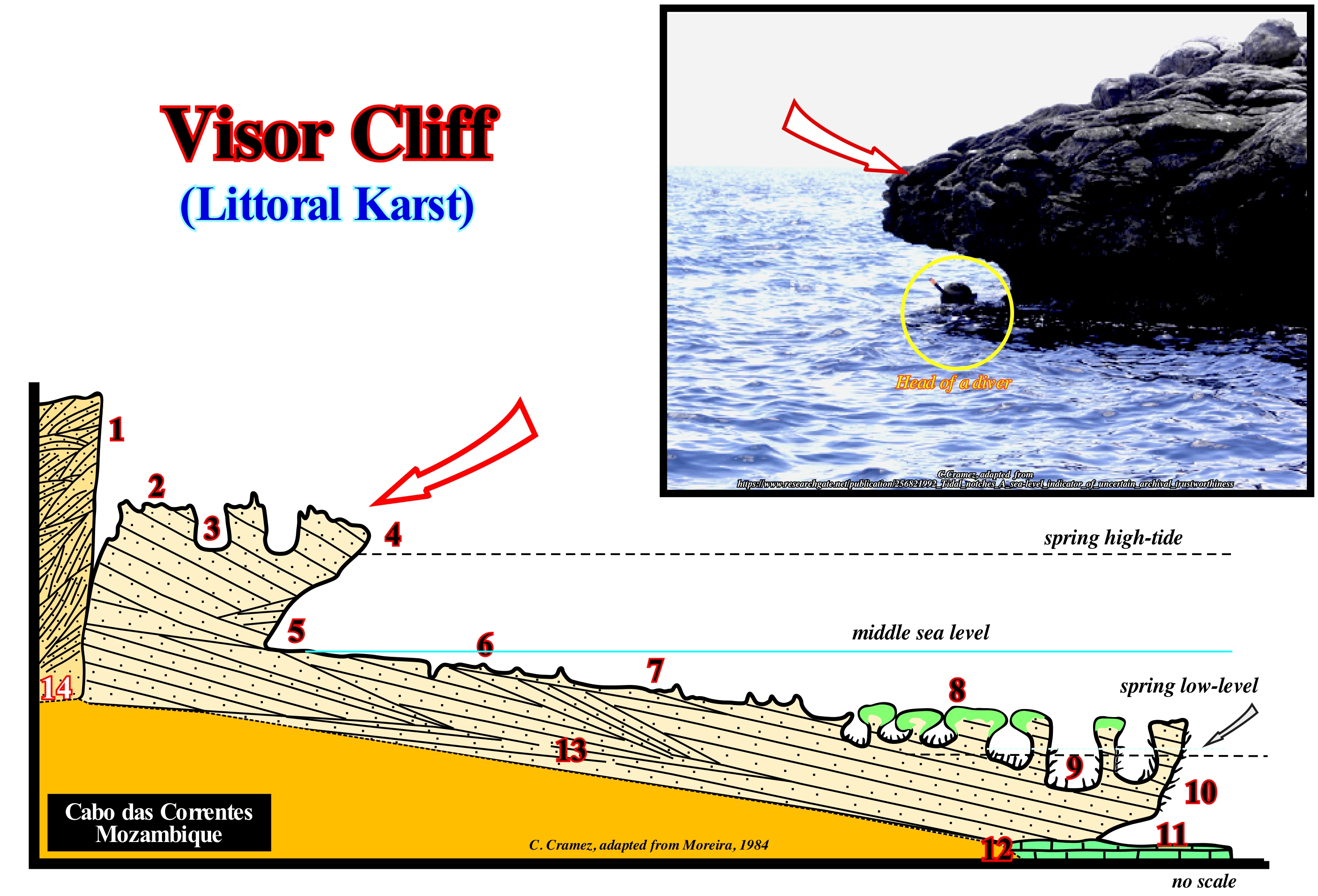
In this geological cross-section of Cabo das Correntes (Mozambique) the main zonations and types of microforms that can be found in a coastal coast are shown in aeolianite and sandstones. From right to left can be distinguished: (1) Alveolized dead cliff ; (2) Platform with pointed littoral clints; (3) Upper littoral potholes, i.e., located above the spring high-tide level ; (4) Visor cliff ; (5) Undercut (notch, groove ; (6) Platform with solution benches and embryonic waterpockets (below middle sea level) ; (7) Platform with solution benches encrusted by calcareous algae ; (8) Tubicolous bioconstructed platform (above spring low-tide level) ; (9) Lower littoral potholes, more or less located at the spring low-tide level ; (10) Overhanging surface cornice due to wave surfing ; (11) Submerged undercut (notch, groove) ; (12) Dead coral reef ; (13) Sandstone and (14) Aeolianite, which are the rocks that make up this coast. In the tropical limestone coastal zones, the cliff presents basal grooves in the form of a niche (called notch, undercut), which develop between high and low tide levels by a double mechanical and chemical action of the waters. The notch is topped by a rocky frontispiece above the level of the high-tide which is called the visor. In this case you can speak in visor cliff. Like any other cliff, on the seismic lines, the visor cliff can only be recognized when it is fossilized by a thick transgressive interval. If the relative sea level* falls (which is not, usually, the case during a marine transgression), the shoreline moves seaward, reducing the extent of the shelf, which allows the progressive erosion of the cliff by the erosive agents. In certain cases, such as, for example, near a river, the cliff can be eroded very rapidly during the formation of an incised valley. The seaward displacement of the shoreline induced by a significant a relative sea level fall, breaks the provisional equilibrium profile of the rivers, which are forced to dig their beds and banks to reach a new provisional equilibrium profile. It is this type of fluvial erosion that can quickly erode the cliffs located near the mouth of the rivers, as in the case illustrated in this figure (geological cross-section of Cabo das Correntes, Mozambique).
(*) The relative sea level is the local sea level referenced either to the top of the continental crust (base of the sediments) or to the sea floor, while the absolute (eustatic) sea level, supposed global, is referenced to the Earth's centre. The relative sea level is the result of the combined action of absolute sea level (glacio-eustasy, tectono-eustasy, geoidal-eustasy and steric sea level rise) and tectonics (subsidence or uplift of the sea floor).
Volcan...............................................................................................................................................................................................................................................................Volcan
Vulcão / Volcán / Vulkan / 火神 / Вулкан / Vulcano /
Mountain or opening (crater) in the mountain, from which, more or less, regularly, gases, fire whirlwinds, rocks in the solid state and substances in melting (lavas) emerge.
See : « Hot Spot »
&
« SDRs »
&
« B-Type Subduction (Benioff) »
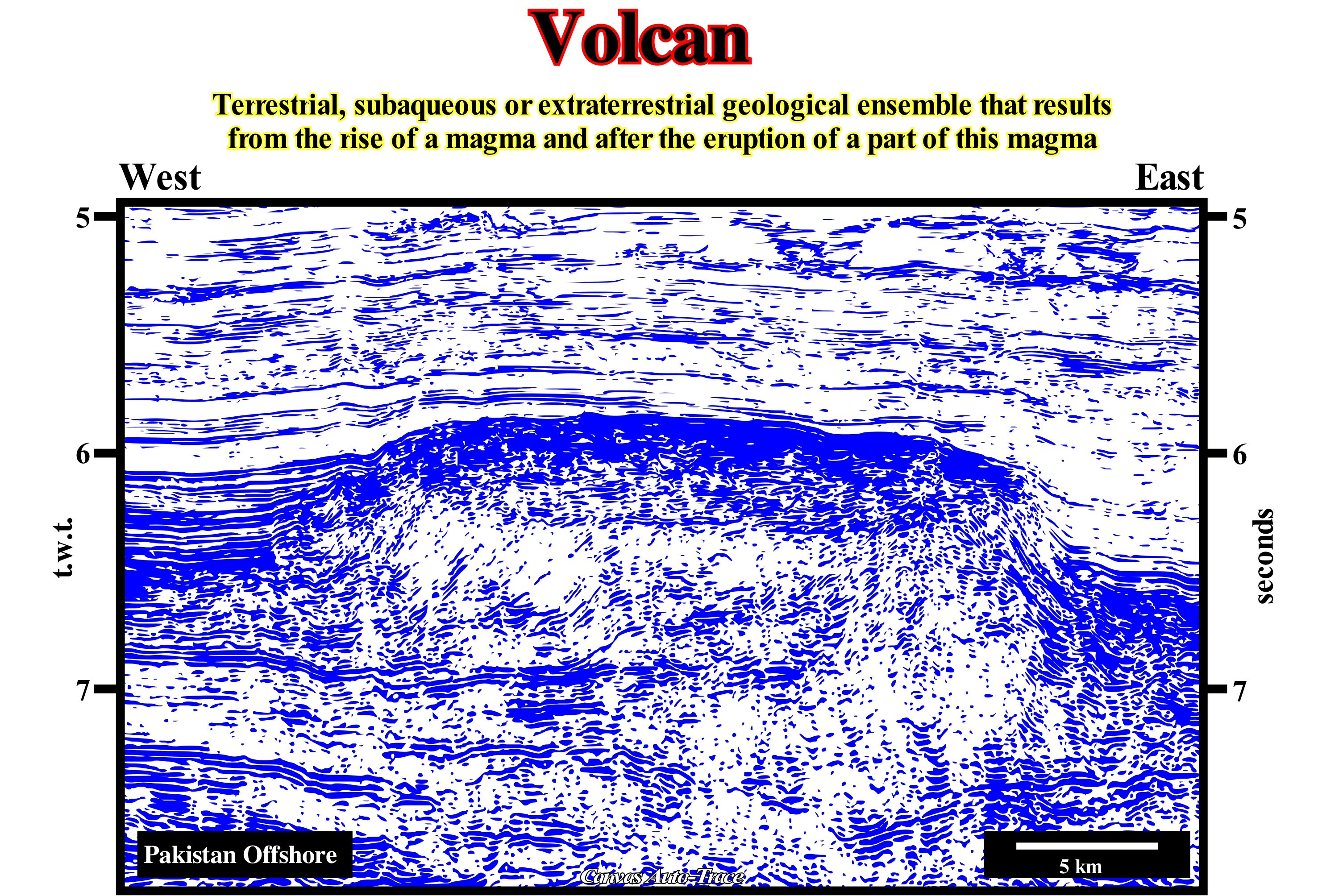
As illustrated in this Canvas auto-trace of a Pakistan offshore seismic line, when magma reaches the Earth's surface, eventually, but not always, it erupts and the lava (a term given to the magma as it reaches the surface) flows into opposite directions forming a cone or volcano. It can be said that a volcanic mountain, usually, in the shape of a cone and a crater at the top, forms around an opening or chimney by the accumulation of solidified lava flows and ash (small rock fragments). Many volcanoes occur on the margin of lithosphere plates, where the movement of the plates generates magma (converging margins) or allows the mantle material to ascend to the Earth's surface (divergent margins). A large number of volcanoes lie far from the margins of the lithospheric plates, in the so-called hot spots, where the Earth's crust is thinner. There are two large families of volcanoes: (i) Composite or stratified volcanoes, which are tall, relatively narrow and built by a multitude of lava flows that thin as they move away from the crater and (ii) Shield volcanoes, unlike the former, are tall, broad, more or less rounded, with the flat top. These latter volcanoes are much less dangerous than the first, once, the lava flows are not, in general, accompanied by pyroclastic material. Composite volcanoes emit pyroclastic remains, while shield volcanoes produce lava flows. The type of volcanic activity also depends on the age of the volcano. The first stages of an eruption are, usually, more vigorous once the magma tries to reach the surface and therefore the pressure is too great. Since the pressure decreases and the chimney forms, the main phase of volcanic activity begins. When the pressure disappears, due to the exhaustion of the magma, the volcanic activity decreases in such a way that it is confined to the emission of gas, which, in time, also ceases and the volcano enters in a period of rest.
Vulcanism..............................................................................................................................................................................................................................Vulcanisme
Vulcanismo / Volcanismo / Vulkanismus / 火山 / Вулканизм / Vulcanismo /
Geological process by which the inner and deep material of a planet is brought and shed to the surface, although a tiny part may reside, some time, in the atmosphere. Geysers and hot springs, even though they are not volcanoes, they are part of vulcanism, involving water and hydrothermal activity. In most cases, vulcanism is a process of cooling the planets. Certain planetary objects, such as Europa (Jupiter's satellite) have a glacial vulcanism, which is another form of vulcanism involving water.
See:« SDRs »
&
« B-Type Subduction (Benioff) »
&
« Volcan »
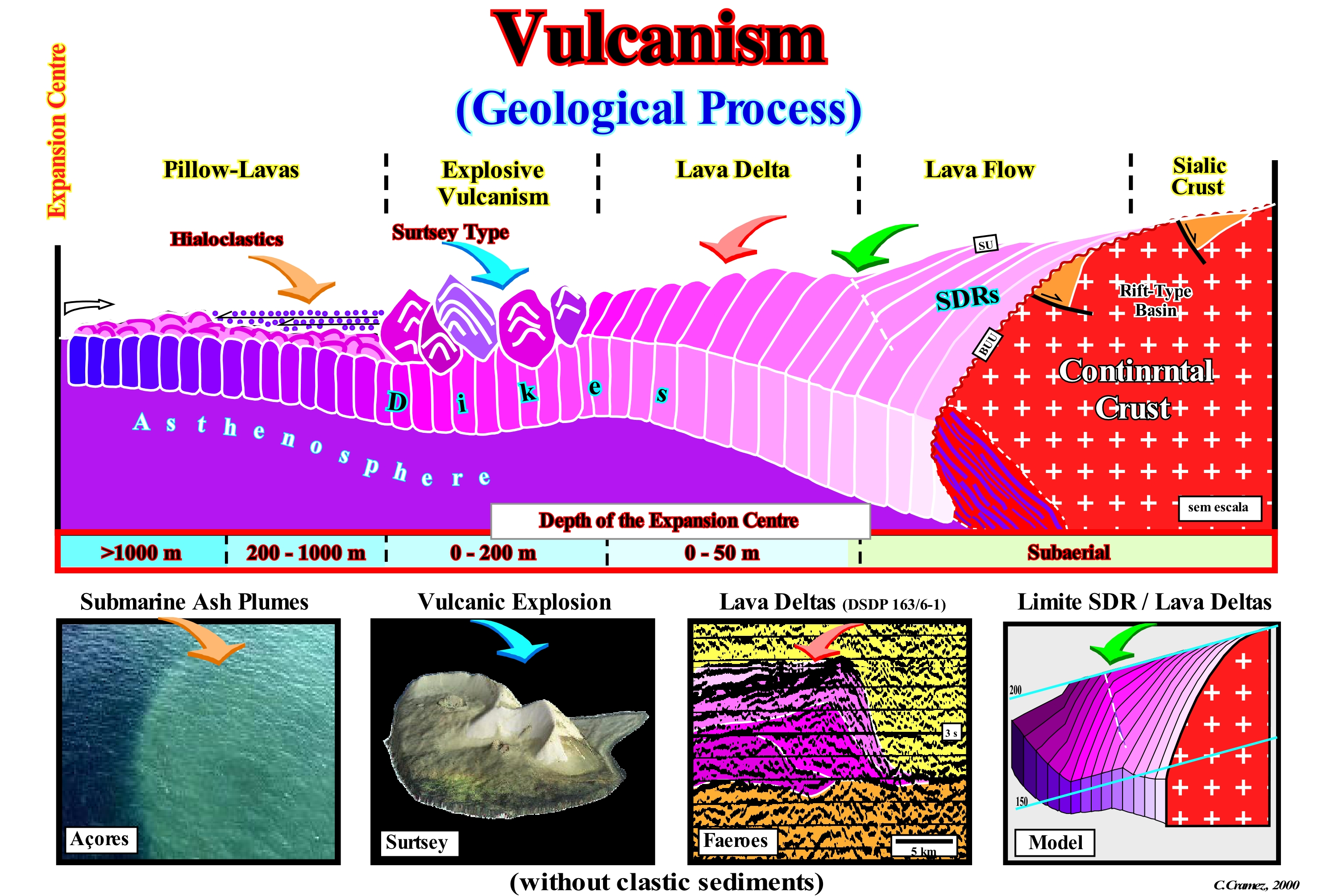
On the Earth's surface there are several forms of vulcanism, although the most important is associated with the formation of volcanoes. However, volcanoes can be of different types and created by different geological processes. Until a few years ago, the great majority of geoscientists thought that the main cause of vulcanism was the subduction of the Earth's crust. In fact, the divergent margins and, in particular, the Atlantic offshores were considered as nonvolcanic margins. This conjecture was, totally, refuted by the studies of the deep offshores and, particularly, by the tentative geological interpretation of the regional seismic lines, which suggested enormous amounts of subaerial volcanism. Several oil exploration wells and the Deep Sea Drilling Project (DSDP) corroborated the presence of subaerial volcanism, which forced the geoscientists to change, radically, the model for opening the Atlantic margins. In this figure is illustrated the model, which Total SA proposed for the divergent Atlantic-type margins (Gulf of Mexico included), where, between conventional oceanic crust (pillow lavas) and continental crust, which has an abrupt limit (there is, practically, no thinning of the continental crust), there is a subaerial volcanic crust, in which the morphology of the volcanic deposits varies according to the depth of the expansion centres (volcanoes): (i) Lava flow (water-depth, more or less, 0 meters) ; (ii) Lava deltas (water-depth between 0 and 50 m) ; (iii) Explosive vulcanism (water-depth between 0 and 200 m). The oceanic crust (type pillow-lava) forms since the water-depth is greater than 200-300 meters i.e., when the expansion centres are under water.


Send E-mails to carloscramez@gmail.com or to carlos.cramez@bluewin.ch with comments and suggestions to improve this glossary.
Copyright © 2009 CCramez, Switzerland
Last updated: September, 2019