
Discordance (Unconformity).....................................................................................................................................................................Discordance
Discordância / Discordancia / Diskordanz / 不整合 / Несоответствие, несогласное залегание / Discordanza /
Erosional surface induced by a relative sea level fall, which may produce an absence of parallelism of the strata to the limits of the stratigraphic cycles. Upper stratal or reflection terminations (truncations and toplaps) occur at the upper limit of a stratigraphic cycle (upper unconformity). Lower stratal or reflection terminations (onlaps and downlaps) occur along the lower unconformity.
See: « Relative Sea Level Fall »
&
« Erosion »
&
« Disconformity »

On this tentative geological interpretation of a Canvas auto-trace of a seismic line of Maracaibo Lake (Venezuela), discordances, i.e., unconformities and erosional surfaces, induced by significant relative sea level falls are, easily, recognized by the terminations of the underlying reflectors, which were truncated (toplaps by truncation). The dislocations were, locally, tectonically enhanced. On the auto-trace of a Gulf of Mexico seismic line, the reflectors overlying the F discordance are, in this area, apparently, parallel to the discordance. However, on seismic lines striking North-South (perpendicular to the line of this tentative interpretation), the lower terminations of the reflectors of the interval overlying the discordance (picking in red) are downlaps, which means that the observed concordance on the West-East auto-traces is apparent. On the auto-trace of a seismic line from Venezuela's onshore (Maracaibo Lake), the geometric relationships between the reflectors, clearly, indicate that the discordance (picked in red) was, locally, tectonically enhanced. The regional geological setting of this area, where the seismic line was shot, is compressional. The sediments were shortened. Several tectonic regimes with σ1 horizontal occurred in this area, particularly during the Cenozoic period. The sediments were shortened and raised, producing important tectonic inversions. The erosional surface associated with the discordance (Upper Miocene) truncated the pre-Miocene sediments creating toplaps by truncation. During the Miocene/Pliocene, another compressional tectonic regime folded the sediments. In certain areas, as it is the case here, the folding was not sufficient to accommodate the sediments to the new volume conditions. Reverse faults were developed in order to shorten more the sediments, so that the volume problems are respected (Goguel's law). During deformation (shortening or lengthening), the volume of the sediments remains, more or less, constant (taking into account the compaction and dissolution). In the geological interpretation of the discordances (unconformities), the incised valley fillings play a very important role, as if can see on the tentative interpretation of an auto-trace of a regional seismic line of the Gulf of Mexico. One of the main problems in identification of discordances is to know what is the preponderant factor: (i)i Eustasy (absolute or eustatic sea level, which is supposed to be global and referenced to the Earth's centre) or (ii) Tectonics. It is important to understand that a shortening produces an uplift, that, generally, it does not imply an erosion. The erosion of uplift sediments is just important when they are exposed to erosive agents, i.e. if they reach the surface. A deep salt dome, for instance, uplift the overlying sediments lengthened them by antiform structures. However, if such antiform structures do not reach the surface, there is no associated erosion. To have erosion, the relative sea level (combined action of the absolute or eustatic sea level and tectonics) must fall in order to expose the sediments at the erosional agents. The sediments must be exhumed. For most geoscientists, the rate of eustatic changes (absolute sea level changes) is greater than the rate of tectonic changes, which means that, basically, all discordances have an eustatic origin although they can be, locally, enhanced by tectonics. For some specialists in structural geology, in certain sedimentary basins, as for instance in foreland basins, the tectonic factor may be preponderant. In the tentative interpretation the discordances on the seismic line of the Gulf of Mexico, it is evident that in their great extent the discordances are cryptic. They are difficult to bring to light from the geometric relations between the different reflectors. What saves the geoscientists in charge of such an interpretation are the fillings of the submarine canyons (in the upper continental slope) and the fillings of incised valleys near and upstream of the basin edges (here coincident with the shoreline). With a significant relative sea level fall, the shoreline and the river mouths are displaced seaward and downwards destroying the provisional equilibrium profile of the water-courses. They are forced to incise their beds to reach a new provisional equilibrium profile creating submarine canyons and valleys incised. These negative bathymetric anomalies induced by the erosion associated with relative sea level falls will be fulfilled after relative sea level rises. The filling of the incised valleys and submarine canyons occurs during the final development of the lowstand prograding wedges level, in association with the marine ingression responsible for the 1st transgressive surface.
Discovered Reserves (HC).......................................................................................................................Réserves découvertes (HC)
Reservas descobertas / Reservas descubiertas (HC) / Reserven entdeckt (HC) / 发现储量(慧) / Разведанные запасы (УВ) / Riserve scoperto (HC) /
Reserves recognized using the exploration wells' results and estimated (with a certain level of confidence) on the basis of the reservoir-rock maps, usually, made from seismic data.
See : « Resourses »
&
« Reserves »
&
« Proven Reserves (HC)»
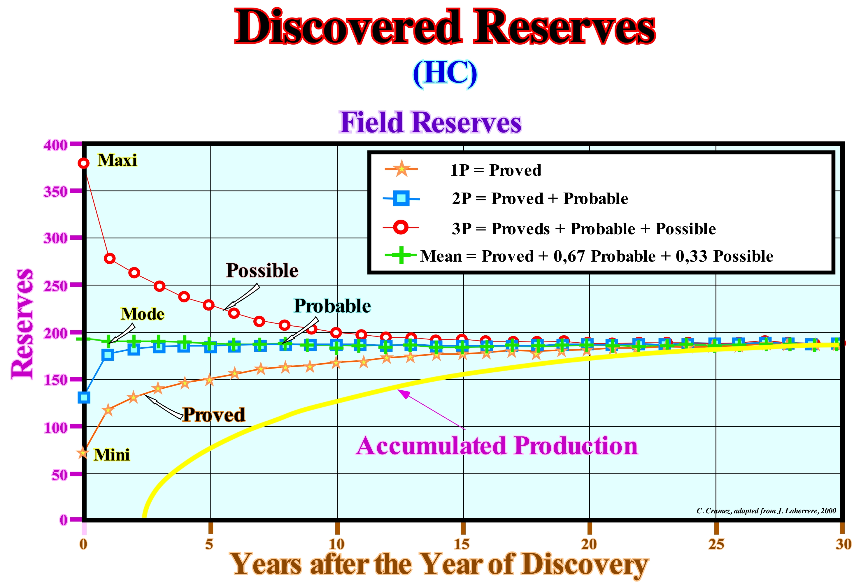
Within the discovered reserves it is necessary to consider: (i) Proved reserves (P1) and (ii) Unproven reserves, which may be Probable (P2) and Possible (P3). The first are those that have been highlighted by exploration wells, with a certainty of 90% and can be commercially produced, taking into account the current economical and technological conditions. Probable reserves are those which, in addition to proved reserves, are likely to exist but are. unlikely, to be, commercially, recoverable under current economical or technological conditions. The probability of recovering probable plus proved reserves varies between 40 and 60%. Possible reserves are those which, in addition to proven and probable reserves, are unlikely to be commercially recovered under appropriate future economic and technological conditions. The probability of recovering the proved plus probable plus possible is, generally, less than 10%. As shown in this diagram, the uncovered reserves (proved, P1, probable, P2 and possible, P3) vary as a function of the increase in accumulated production (excluded exogenous factors). As can be seen in the diagram shown above, as production increases (since the moment of discovery and as the years of production increase), probable (P2) and possible (P3) reserves become proved reserves (P1), which in the first 10/15 years of production significantly increases the value of proved reserves. Experience shows that the mode value of reserves, i.e., the most probable (most likely), which has a probability of more or less 67%, is the value that most closely approximates the ultimate reserves. As suggested by the diagram above, which corresponds to a true example of oil production, it can be said the uncertainty of reserves decreases with time as hydrocarbons are produced and that, when the field is depleted, the exact value of the reserves is finally known.
Discrepancy (Koksma inequality)...........................................................................................................Inconsistance (Inégalité Koksma)
Discrepância / Discrepancia (desigualdad de Koksma) / Diskrepanz / 差异 / Неустойчивость (горной породы) / Discrepanza /
Divergence or disagreement, between facts or allegations. In geology, the term discrepancy is used to express the difference between what is expected and what actually occurs, such as for instance to express the difference between an tentative geological interpretaion of a seismic line and the geological reality.
See: « Chronostratigraphic Line »
&
« Geological Section »
&
« Correlation »
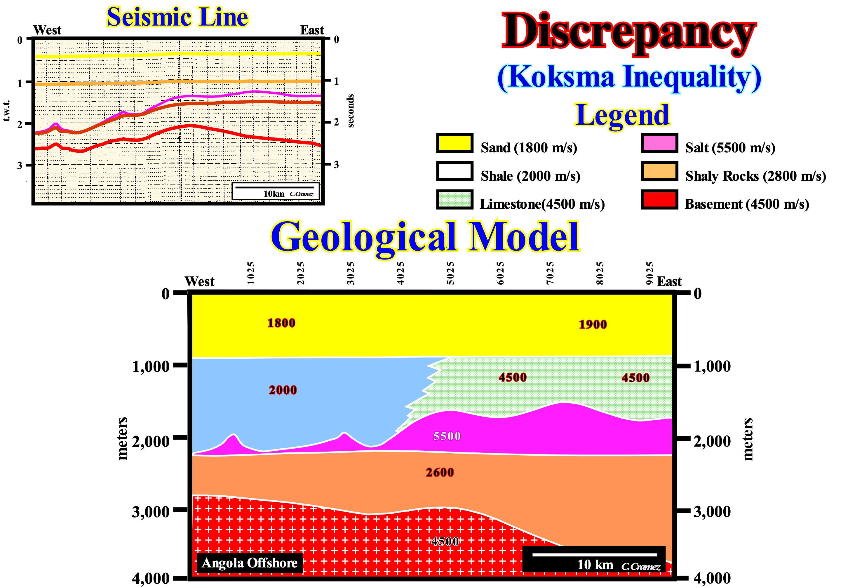
The term discrepancy is, sometimes, misused in place than disparity (big difference between measurable things such as geological age of a rock, flow velocity of a current, etc.). A discrepancy is a difference between things that should be the same. A discrepancy is a contradiction, variation, incompatibility, i.e., a difference between what we expected (predicted, estimated, expected ...) and what we find. A very small discrepancy is, in general, significant. This figure shows the discrepancy between a tentative geological interpretation of an offshore time seismic line from Angola and the most probable geological model (constructed from the results of the exploration wells and migrated seismic line converted into depth). Geoscientists, when interpreting seismic data, can never forget that a seismic line is a time profile (double time, i.e., round trip time of seismic waves) and not in depth, as a geological section. Seismic intervals show lateral variations of propagation velocity of acoustic waves or thickness variations and whole series of seismic artefacts appear that mask much the geological reality. In this particular case, the seismic horizon that emphasizes the top of the basement (in red) has, on the seismic line, a geometry very different from the geometry visible in the geological model. On the seismic line, the basement shows a marked buried high, while in the geological model, it dips eastward, more or less, regularly. The reason for this discrepancy is, in part, due to the lateral variation of salt thickness (on the seismic line, this interval, which is limited between the second and third reflectors, from below, is not very thick because the acoustical waves cross this interval very rapidly with a velocity around 5000 m/s) and partly due to lateral facies variation of the sedimentary interval overlying the salt. In the eastern sector, the facies are carbonate, in which seismic waves travel with a velocity of more or less 4,500 m/s). In the western sector, the facies is shaly (seismic waves velocity of about 2000 m/s). Thus, in the eastern part of the seismic line, the acoustic waves spend less time crossing the sedimentary intervals and, obviously, the reflector associated with the top of the basemen is less deep (it is pull-up). The opposite happens with the reflectors associated with the base of the salt and the overlying interval. They are, slightly, pull down. On the seismic lines of offshore, in particular, when they illustrate the passage of the continental shelf (depth-water less than 200 meters) and deep offshore, a very particular attention has to be taken to influence the depth-water. The seismic waves propagate much slower in water than in sediments. The more abrupt is the passage from the continental shelf to the abyssal plain, the lower will be the reflectors underlying the strong water depths. They are pull-down. Contrariwise to a very general idea, in divergent continental margins, particularly, when the passage from the continental shelf to the abyssal plain is abrupt, the geometry of the unconformity associated with the break-up of the supercontinent lithosphere and particularly the sedimentary substratum, in depth, dips, almost always, continentward and not seaward as, apparently, suggested on time seismic lines. Geoscientists in charge of the tentative geological interpretation of the seismic lines must, always, have to correct, even mentally, the influence of the water-depth lateral variations. This is, relatively, easy and extremely important, particularly when the variations are abrupt. Although such a correction is trivial, it is, often, overlooked which may have important consequences in assessing the oil potential of an area, particularly, in the assessment of the oil/migration petroleum subsystem. In deep offshore, rarely, the direction of hydrocarbon migration, generated by the source-rocks, continentward. In the majority of cases it is seaward. A whole series of dry wells can be explained in this way, i.e., by an inappropriate direction of hydrocarbon migration. In offshore exploration, once the exploration team proposes a continentward hydrocarbon migration to justify a potential prospect, it must, imperatively, show to the manager exploration the results of all refutation tests carried out to try to corroborate such a conjecture.
Desintegration (In chain)....................................................................................................................................................Désintégration (En chaîne)
Desintegração / Desintegración (cadena) / Zerfallsreihe, Disintegration (Kette) / 放射系, 解体(连锁) / Разрушение, дезагрегация (пород) / Decadimento (catena) /
A series of disintegrations that appear by spontaneous transformation of an unstable radioisotope, allowing to reach a chemical element whose atomic nucleus is stable, i.e., nonradioactive. Lead is, usually, the stable element at which the desintegration chains end.
See : « Isotope »
&
« Radiometric Dating »
&
« Nuclear Fusion »
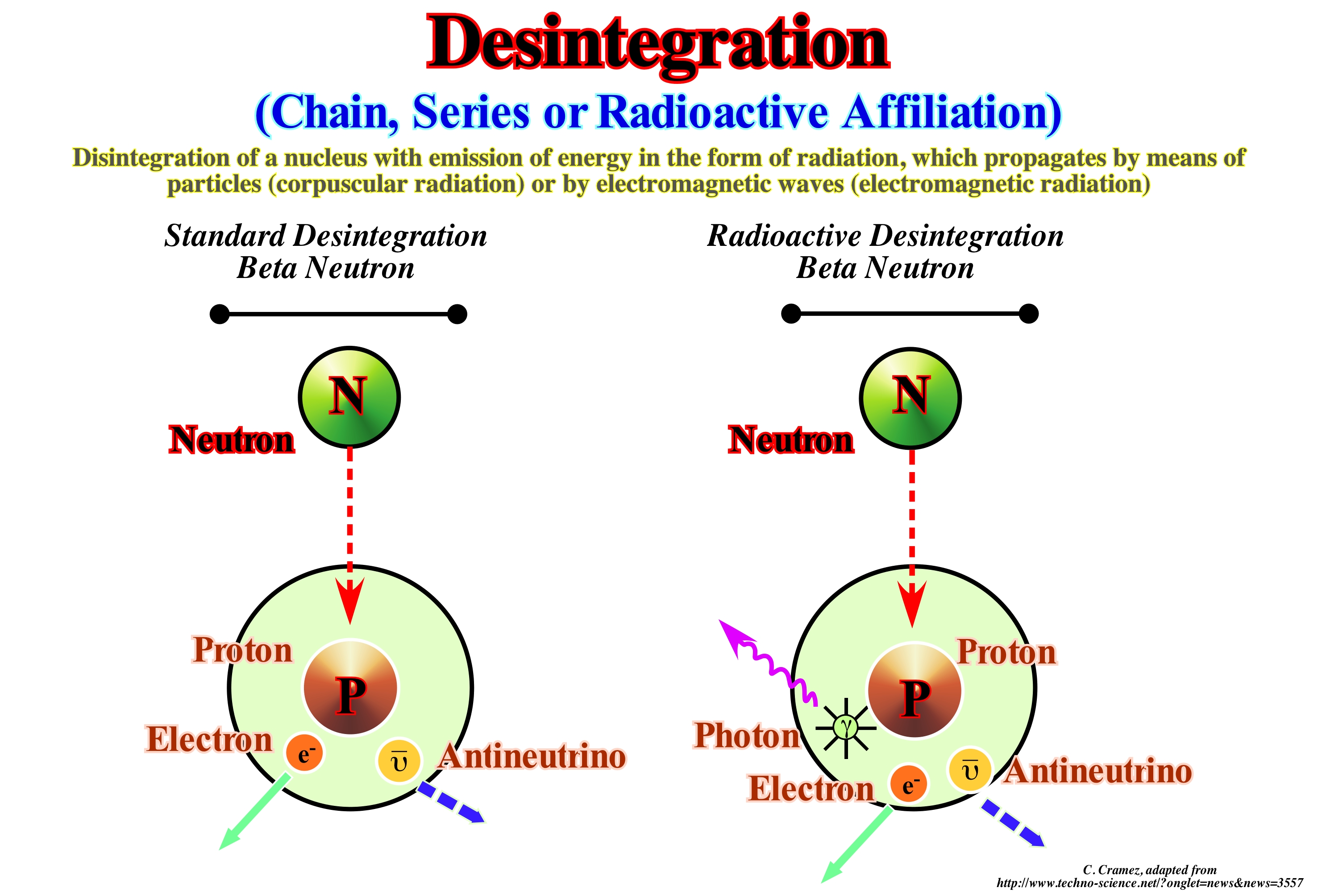
The neutron * is only stable within the nucleus of a stable atom. It takes about 15 minutes for a free neutron to turn into other particles: a proton, an electron, and an anti-neutrino. This beta neutron disintegration has been studied for dozens of years without experimental proof of the occasional photon emission ** provided by theory. This measurement is difficult because the life of a neutron is very long and very few neutrons disintegrate simultaneously. Among those who disintegrate very few emit photons. To make matters worse, even emissions are very important. The National Institute of Standards and Technology (NIST) has determined that, on average, a little more than three neutrons over 1,000 that decompose produce a photon with a very low energy level, but sufficient to be observed. The value is measured with only 10 percent uncertainty, which is considered remarkable, since this radioactive disintegration had never been observed before. At the end of a micro-second after the Big Bang, the most immediate union made by the particles called quarks was to form groups of three. Such a group of three quarks forms a system in which the quarks move and interact although they are distinct and strongly connected. This system forms a nucleus (the volume of a nucleus is about 10,000 times that of a quarks). At the end of 380,000 years later the Big Bang, when the temperature dropped to about 3,000° C, a new particle appeared, the electron that went around the nucleons. Between the electron and the nucleon there is nothing, everything is empty. A nucleon, function of the cases, is composed of neutrons and protons. The elementary particles identified so far are in restricted numbers and of two species. Those that constitute matter, i.e., those that constitute the protons, neutrons and electrons are called fermions (the quarks belong to this category). Those that make up the radiations and the forces acting on matter are called bosons.
(*) A neutron is a massive particle with no electric charge. It is a baryon (a sub-atomic particle composed of three quarks i.e. by elementary particles sensitive to the strong nuclear interaction) formed by two quarks below and a quark above. There are six types of quarks: the ascending quark (u), the descending quark (d), the strange quark (s), the charm quark (c), the quark below (b), and the quark above (t). Quarks that are fermions (particles with spin or intrinsic angular momentum of fractional charge non-integer value) form the hadrons. Particles with integer spin are called bosons. Neutrons and protons constitute the nuclei of atoms. The neutron has an average life of about fifteen minutes outside the atomic nucleus, when it emits an electron and an anti-neutron to become a proton. Neutrons, which have a mass similar to that of protons, are necessary for the stability of atomic nuclei (except for hydrogen).
(**) A photon is an elementary particle, the quantum of any form of electromagnetic radiation, including light. It is the particle that measures the electromagnetic force, even when static through virtual photons. The photon has a zero mass and, consequently, the interactions of this fundamental force are observable both microscopically and macroscopically. Like all elementary particles, a photon exhibits wave-particle duality, that is, it simultaneously exhibits the properties of a wave and a particle.
Disintegration, Disaggregation (Rocks).................................................................................................Désagrégation
Desagregação / Desagregación / Auflockerung, Auflösung / 解体 / Разрушение (размельчение) / Disaggregazione, Disintegrazione /
Separation or reduction of an aggregate (rock) in its components. Mechanical alteration, i.e., the process of disintegrating a rock by the action of ice, crystal growth, water absorption and other physical processes, are typical examples.
See: « Dsintegration »
Disphotic Zone....................................................................................................................................................................................Zone dysphotique
Zona disfótica / Zona disfótica / Disphotic Zone / 弱光层 / Дисфотическая (малопродуктивная) зона / Zona disfotica /
Ocean area extending from about 50 meters depth, where the euphotic zone ends, up to about 1,000 meters. Ocean zone where there is enough sunlight for the animals to see, but that is insufficient for photosynthesis.
See: « Shefal Accommodation »
&
« Euphotic Zone »
&
« Photic Zone »
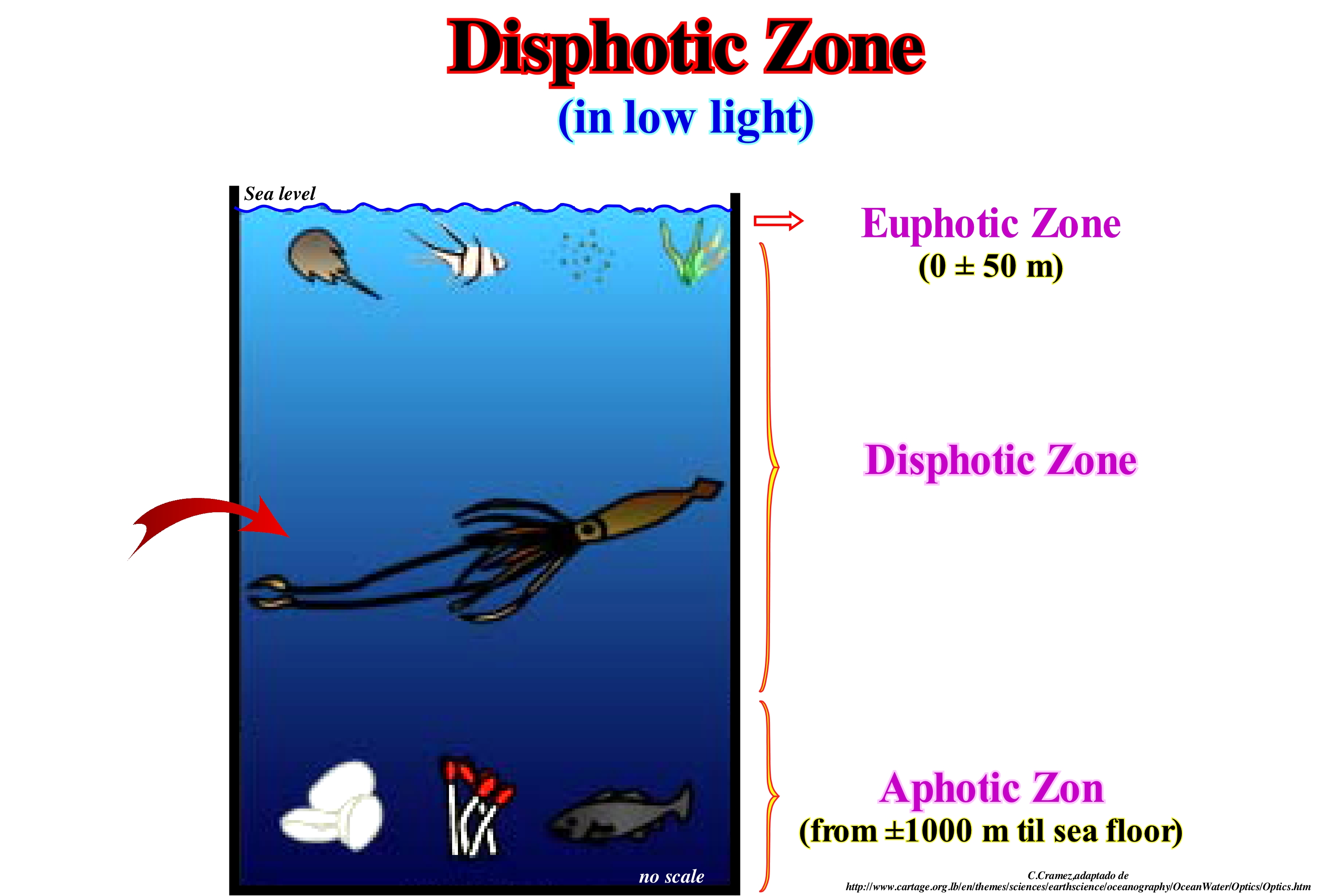
When the sunlight penetrates the oceans, it is absorbed which allows to consider three zones, function of the amount of sunlight they receive: (i) Euphotic Zone; (ii) Disphotic Zone and (iii) Aphotic Zone. The euphotic zone extends between the surface and a depth of about 50 meters, depending on the time of year, the time of day, the clarity of the water as well as the presence of clouds. The euphotic zone is the water column of the ocean where sunlight is sufficient for the plants to perform photosynthesis which initiates most of the food chains on Earth. The photosynthesis is a physical-chemical process at the cellular level carried out by living beings with chlorophyll using CO2 and OH2 to obtain C6H12O6, i.e., glucose, through the energy of sunlight, according to the following equation: Sunshine + 6CO2 + 12H2O ➞ 6O2+ 6OH2 + C6H12O6. Without photosynthesis, animals and many other heterotrophic beings (who lack the ability to produce their own food) would be unable to survive. The basis of their food will always be in the organic substances of green plants (with chlorophyll). All plankton, vareque (all seaweed family of algae) and vegetal plankton are found in the euphotic zone. The Disphotic zone is characterized by a presence of sunlight sufficient for the animals that live there to see, but insufficient for the plants to perform the photosynthesis. The depth of the Disphotic zone is, greatly, affected by the turbidity of the water and the seasons. Generally, as illustrated in this sketch, it is, rarely, less than 1,000 meters. However, in certain cases the lower limit may be deeper and certain geoscientists advance even depths of the order of 5,000 meters. The aphotic zone, which is below the Disphotic zone, is the realm of darkness and thus of very particular creatures such as the giant squid, pelican eel (so called because its mouth is similar to that of a pelican), vampire squid, etc. Many of the organisms that live in the oceans depend on sunlight. The plants, the seaweed and photosynthetic vegetal plankton,use sunlight to obtain energy through photosynthesis. Then these organisms are eaten by larger animals, which in turn are eaten by larger animals and so on. Sunlight is not only the basis of the food chain, but also warms the water of the oceans, making them more conducive to animal life. On the other hand, sunlight induces the formation of marine currents, which many animals them use to move. Although in the aphotic zone, there is no light, certain communities find near the deep hydrothermal vents the energy necessary to survive. The euphotic zone is the upper layer of the oceans which is bathed by sunlight during the day. This zone is also called light zone or epipelagic zone (on top of the sea). The depth of the euphotic zone, that is, the passage to the disphotic zone depends on the transparency of the water. When the water is clear the euphotic zone can be very thick. The euphotic zone is defined in terms of light and not in terms of depth. Many plants and other photosynthetic organisms live in the euphotic zone, where food is abundant. Because photosynthesis is a process by which sunlight and CO2 are converted into food (chemical energy contained in carbohydrates) and oxygen, it creates about 90% of the Earth's oxygen. The oceans contain about 60 times more carbon in the form of dissolved inorganic carbon than in the pre-anthropogenic atmosphere (± 600 x 1015 g C). At time scales <1015 years, the oceans are the largest reservoir of inorganic carbon (± 38,000 x 1015 g C) in exchanges with atmospheric carbon dioxide (CO2) and as a result, the oceans exert a dominant control over CO2 levels atmospheric. The average concentration of inorganic carbon in the oceans is ± 2.3 mmol kg-1 and its residence time is, more or less, 200 ka. The CO2 dissolved in the oceans occurs mainly in three inorganic forms: a) Free aqueous CO2 ; b) Bicarbonate (HCO3-) and carbonate ion (CO32-). A smaller form is the true carbonic acid (H2CO3) whose concentration is less than 0.3%. The sum of free aqueous CO2 and bicarbonate (HCO3-) is denoted by (CO2). Most of the inorganic carbon dissolved in the modern ocean is in the form of HCO3- (> 85%) (https://www.soest.hawaii.edu/ oceanography/faculty/zeebe_files/Publications/ZeebeWolfEnclp07.pdf). As the solubility of CO2 decreases with temperature (http: // engineeringtoolbox.com /gases-solubility-water-d_1148.html), if the temperature of the oceans increases the amount of CO2 in the atmosphere increases.
Dissolution (Solution)...........................................................................................................................................................................................Dissolution
Dissolução / Disolución / Lösung, Auflösung / 解散 / Разложение (растворение) / Dissoluzione /
Chemical reaction in which a continuous material is dispersed as ions in a liquid. Halite (NaCl) dissolves when placed in water.
See: « Diagenesis »
&
« Compensatory Subsidence »
&
« Goguel's Principle »
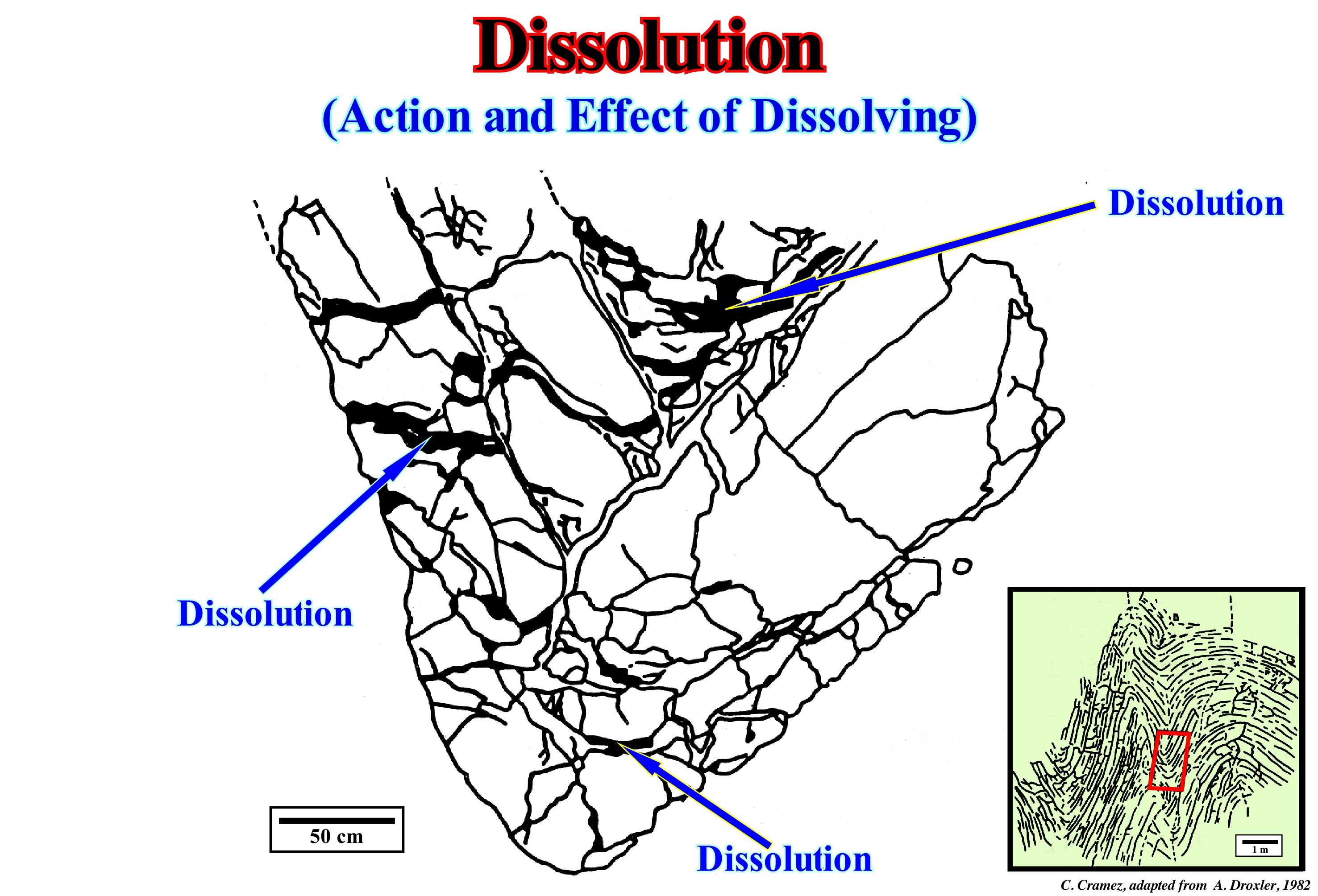
In the Jura mountains, Switzerland, where facies are mostly carbonate, dissolution is sometimes an important phenomenon, as illustrated in this figure (areas painted in black are dissolved areas). At the mesoscopic scale (outcropping scale, i.e., the continuity scale), anticline structures are perfectly concentric and without great dissolution losses, as can be seen in the lower right corner of this sketch. In certain cases, the dissolution may reach more than 30% of the total volume of the rock, That which means that the Goguel's Law, which says that during deformation the volume of the rocks is, more or less, constant (taking into account compaction), should be used with great care. The volume of carbonate material, lost by dissolution, during stylolization (formation of stylolites) may also be very important. Any differential movement, under pressure, is almost always accompanied by dissolution and formation of stylolites (diagenetic formation). In carbonate formations, but also more, rarely, in sandy and quartzite formations, the geoscientists calculate, roughly, the volume of rock lost by stylolization (sometimes from fossil deformation), which appears as an event an initial deformation phase. As the direction of the stylolites is parallel to the σ1 (maximum effective stress) of the tectonic regime that deformed the rock, to calculate the volume lost by dissolution the geological profiles orthogonal to the σ1 are absolutely indispensable (to transform a three-dimensional law into a two-dimensional law). Dissolution phenomena are also very frequent and important in evaporite basins. The salt dissolution can produce very complicated structures, such as those described by Arbenz (1968) in the Williston basin (USA), which were created by selective dissolution of the salt of Devonian evaporites, which created a compensatory subsidence. This mechanism, in its simplest form, corresponds to a selective lixiviation of a part of the salt interval with a collapse of the roof which creates available space for the sediments (accommodation).
Distal Downlap..........................................................................................................................................Biseau de progradation distal
Bisel de progradação distal/ Bisel de progradación distal / Distale downlap, Distalen Bevel Progradation, Progradierender Keil distalen / progradational 楔形末端, 远端 downlap / Подошвенное прилегание с удалением от берега / Progradazionale bisello distale, Distal downlap
Downlap oriented basinward and in the direction of the regional sediment influx. The great majority of the downlaps are distal. Locally, in particular, in overbank deposits (submarine slope fans, for instance) the downlaps are not distal. They are oriented, roughly, perpendicularly, to the direction of the regional sedimentary influx.
See: « Downlap »
&
« Gull Wings (turbidites) »
&
« Negative Coastal Aggrtadation »
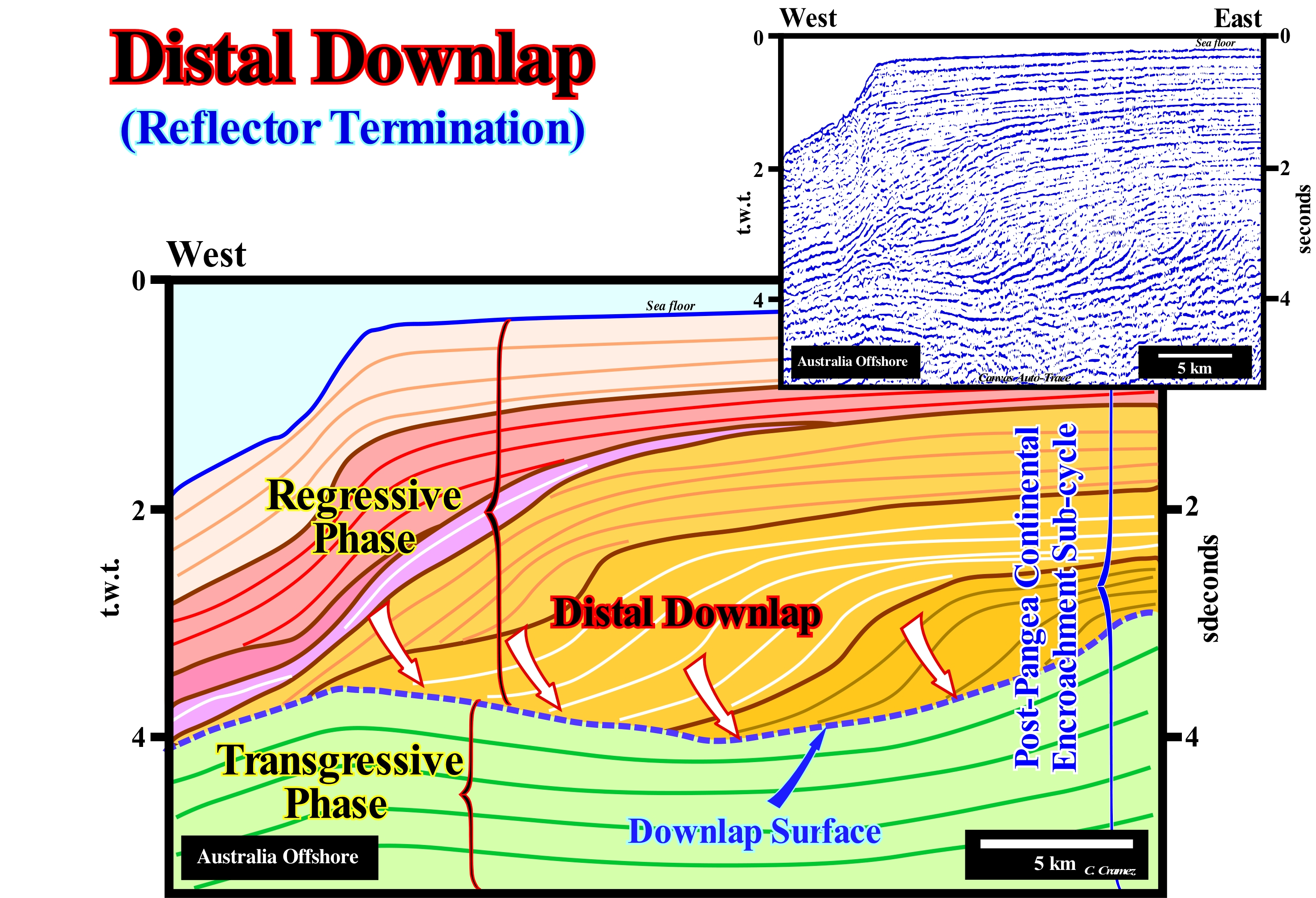
The western offshore of Australia corresponds to the stacking of several basins of the classification of the sedimentary basins of Bally and Snelson (1980), which from the bottom up are: (i) Precambrian Basement or, locally, a, more or less, flattened Paleozoic folded mountain belt ; (ii) Mesozoic rift-type basins (Late Jurassic/Early Cretaceous) and (iii) A Mesozoic/Cenozoic Atlantic-type Divergent Margin. The rift-type basins correspond to the lengthening of the small supercontinent Gondwana, which with the small supercontinent Laurasia formed the Pangea supercontinent. The rift-type basins are separated from the divergent margin by the break-up unconformity of the lithosphere. Two tectono-sedimentary phases (transgressive and regressive phases) can be evidenced within the post-Pangea continental encroachment (divergent margin), which was induced by the second 1st order eustatic cycle of the Phanerozoic*. On this tentative geologically interpretation of a Canvas auto-trace of a particular seismic line from this offshore, the regressive phase of the post-Pangea continental encroachment cycle is, perfectly, visible above the transgressive phase (coloured in green). The sediments of the regressive phase have a progradational geometry, in which the distal downlaps (parallel to the regional terrigeneous influx) are preponderant. On the contrary, sediments of the transgressive phase have an aggradational geometry and by a, more or less, parallel an internal configuration of the sedimentary intervals that compose it. The geometry, globally, retrogradational of this phase, is not visible in this tentative interpretation. However, it is very well marked on regional seismic lines. The transgressive and regressive phases are separated by major downlap surface (continental slopes), which underlines the peak (acme) of Cretaceous transgressions**, which occurred at about 91.5 Ma (millions of years ago). Globally, the sediments of the transgressive phase are associated with absolute or eustatic sea level rise (not to be confused with a relative sea level rise, which is local and referenced to any point of the Earth's surface, which may be the top of the continental crust or the sea floor). The sediments of the regressive phase were deposited during the absolute sea level fall of the associated 1st order eustatic cycle. The post-Pangea continental encroachment stratigraphic cycle was induced by a 1st order eustatic cycle (time-duration greater than 50 Ma), which was created, mainly, by the volume variations of the oceanic basins produced by ocean expansion and by the subduction zones that gradually eliminate the old oceanic crust. These conjectures can just be corroborated if the amount of water, in all its forms, has been constant since the Earth's formation (4.5 Ga). After the break-up of the Pangea supercontinent, the absolute or eustatic sea level rose, during the oceanic expansion, which induced the formation of several oceans and high oceanic mountains reduced the volume of the ocean basins. Absolute sea level began to fall as long as subduction of the old oceanic crust along the subduction zones (A-type and B-type) became predominant in relation to the spreading, forcing certain seas to disappear. The boundary between the eustatic rise and the eustatic fall occurred in the Cenomanian/Turonian. The sedimentary packages, which form the post-Pangea continental encroachment cycle, i.e., the continental encroachment sub-cycles and the sequence-cycles, were deposited during relative sea level rises, either in acceleration or deceleration, associated with 2nd and 3rd order eustatic cycles, in which tectonics (subsidence or uplift) and glacio-eustasy play an important role.
(*) The Phanerozoic is the geological eon that began after the break-up of the Proto-Pangea or Rodhinia supercontinent and in which the geoscientists consider three geological eras: (i) Primary Era or Paleozoic, that goes from the Cambrian until the end of the Permian ; (ii) Secondary Era or Mesozoic (from the Triassic to the end of the Cretaceous ); (iii) Tertiary Era or Cenozoic (from the Paleogene Period to Today).
(**) The term transgressions refers to the set of increasingly important marine ingressions and increasingly smaller sedimentary regressions. Sedimentary regressions are deposited during the periods of relative sea level interval occurring after each marine ingression. The retrogradational geometry of the transgressions is well marked when the accommodation rate increases and the terrigeneous influx remains constant, or when the accommodation rate is constant, and the terrigeneous influx decreases.
Distal Onlap...........................................................................................................................................................Biseau d'aggradation côtière
Bisel de agradacção distal / Bisel de agradación distal / Distale Onlap, Distalen Bevel Verlandung / 远端上超 / Подошвенное налегание с удалением от берега / Onlap distale, Bisello d’aggradazione distale /
Onlap oriented basinward in the direction of sediment influx. When slightly tilted to the sea, tan onlap distal onlap can be, sometimes, misinterpreted as a downlap.
See: « Onlap »
&
« Proximal Onlap »
&
« Aggradation »
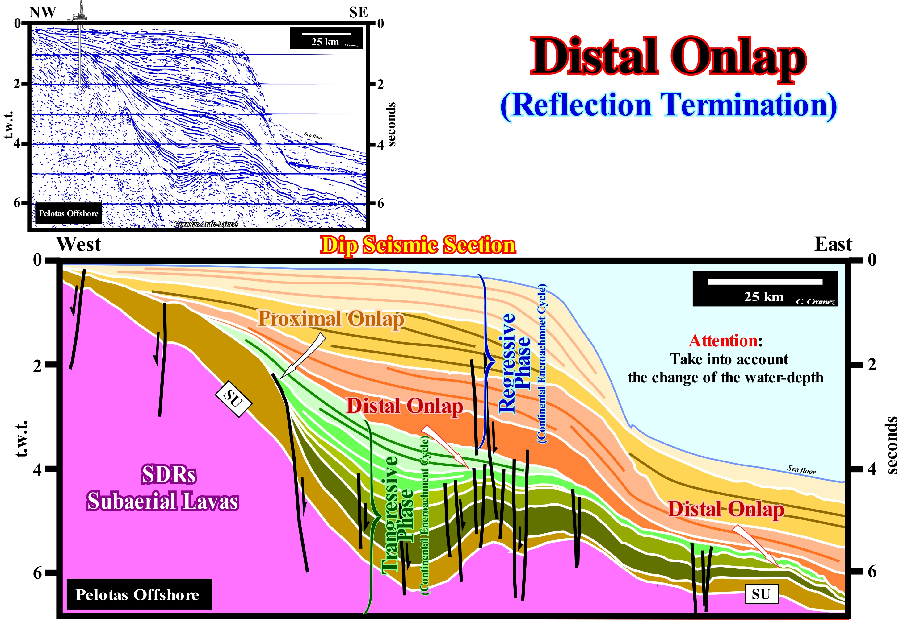
Distal onlaps are easily recognized in this tentative geological interpretation of a Canvas auto-trace of a regional seismic line from the divergent margin of the South Atlantic (Pelotas Offshore - Brazil). In this offshore, the petroleum basement is formed mainly by sub-aerial lavas (SDRs), which, locally, fossilize probably Pre-Cambrian or Paleozoic sedimentary interval but not Cretaceous. In this tentative interpretation, rift-type basin are not visible. The volcanic flows were deposited, immediately, after the break-up of the lithosphere of the small supercontinent Gondwana, since the South America and Africa lithospheric plates of became individualized and began to move away from each other (continental drift and oceanic expansion). This means that the sub-aerial lavas post-date the Late Jurassic/Early Cretaceous rift-type basins (not visible in this tentative), which were formed during the lengthening time of the small Gondwana supercontinent (component of the supercontinent Pangea). Most likely, the sources of the terrigeneous influx during the development of the divergent margin have been were the basement and/or the old lava flows , that outcrop in the onshore. Distal onlaps are identified with great difficulty in the lower part of the margin, in the transgressive and retrogradational phase of the post-Pangea continental encroachment cycle*, notwithstanding the seismic pitfall introduced by the abrupt water-depth increasing (continental slope, relatively short and very steep). A rapid water-depth change, as seen on this offshore, produces, on the seismic lines in time, an apparent deepening (pull-down) of the seafloor and underlying reflectors (seismic artefact). The seismic waves propagate more slowly in the water than in the sediments (330 m/s in the air, 1,450 m / s in the water, 2,300-4,000 m/s in the sediments, 5,000 m/s in the granite, etc.). As sedimentary rocks are compacted with burial, the deeper they are the faster the speed of the waves that cross them. The highest velocities are reached in gypsum and anhydrite at around 6,000 m/s. In the dolomites, they vary between 5,000 and 5,500 m/s, and about 5,000 ms in the limestones. A geoscientist can never forget that the great majority of seismic lines are profiles in time rather than in depth. Any lateral variation of the velocity of the seismic waves in the sediments (or the sediment/water interface) produces important deformations in the reflectors, without any geological significance. In a depth version of the seismic line used to construct this auto-trace, all seismic reflectors, downstream of the present continental edge, are under a water-depth higher than 2,000 m, which considerably modifies the basin geometry in relation the time version. Probably, many of the distal onlaps that in this tentative interpretation dip seaward (eastward), will incline continentward in a depth version. In conventional seismic lines, the vast majority of the sedimentary interfaces of continental margin offshores (Atlantic- or not-Atlantic type) with a sharp continental slope inclination, induce downlaps and onlaps dipping seaward. However, in reality, as in seismic lines in depth, they dip, generally, continentward. When such a fact is not taken into account, the consequences, particularly in oil exploration, can be catastrophic. Many of the dry wells (without hydrocarbon) drilled in the offshores, particularly in the deep offshore, can be explained by an erroneous structural behaviour deduced just from seismic lines in time. The proximal onlaps, which terminate in the opposite direction of the terrigeneous influx, that is to say, oriented, often, continentward, are also well visible in this tentative interpretation. In the post-Pangea regressive phase of the continental encroachment cycle, which is above the transgressive phase, proximal onlaps are more conspicuous than distal onlaps.
(*) Within the continental encroachment cycle that forms a divergent continental margin, which is induced by a 1st order eustatic cycle (duration greater than 50 My), two tectono-sedimentary phases are distinguished: (i) Transgressive Phase, at the base and (ii) Regressive Phase, at the top. The transgressive phase, whose overall geometry is retrogradational, was deposited during the absolute (eustatic) sea level rise, while the regressive phase, whose geometry is progradational, was deposited during the fall of the absolute or eustatic sea level (global sea level referenced to the Earth's centre or to a satellite).
Distal Overbank Mudstone...........................................................................................................Argile externe (Débordement)
Argilito Externo (de transbordo) / Arcilita externa (de transbordo) / Distale Übersarung Tonstein /远端漫滩泥岩/Дистальный сбросовый сланец /Argilliti esterno (spillover) /
A shaly rock deposited on the distal part of turbiditic levees, associated with the submarine slope fans (SSF), when the turbiditic currents overflow the morphological anomaly between the already deposited levees, where they flow, which, sometimes, cancorresponds to a channel (when there is erosion).
See: « Apron »
&
« Slope Fan (submarine) »
&
« Turbiditic Current »
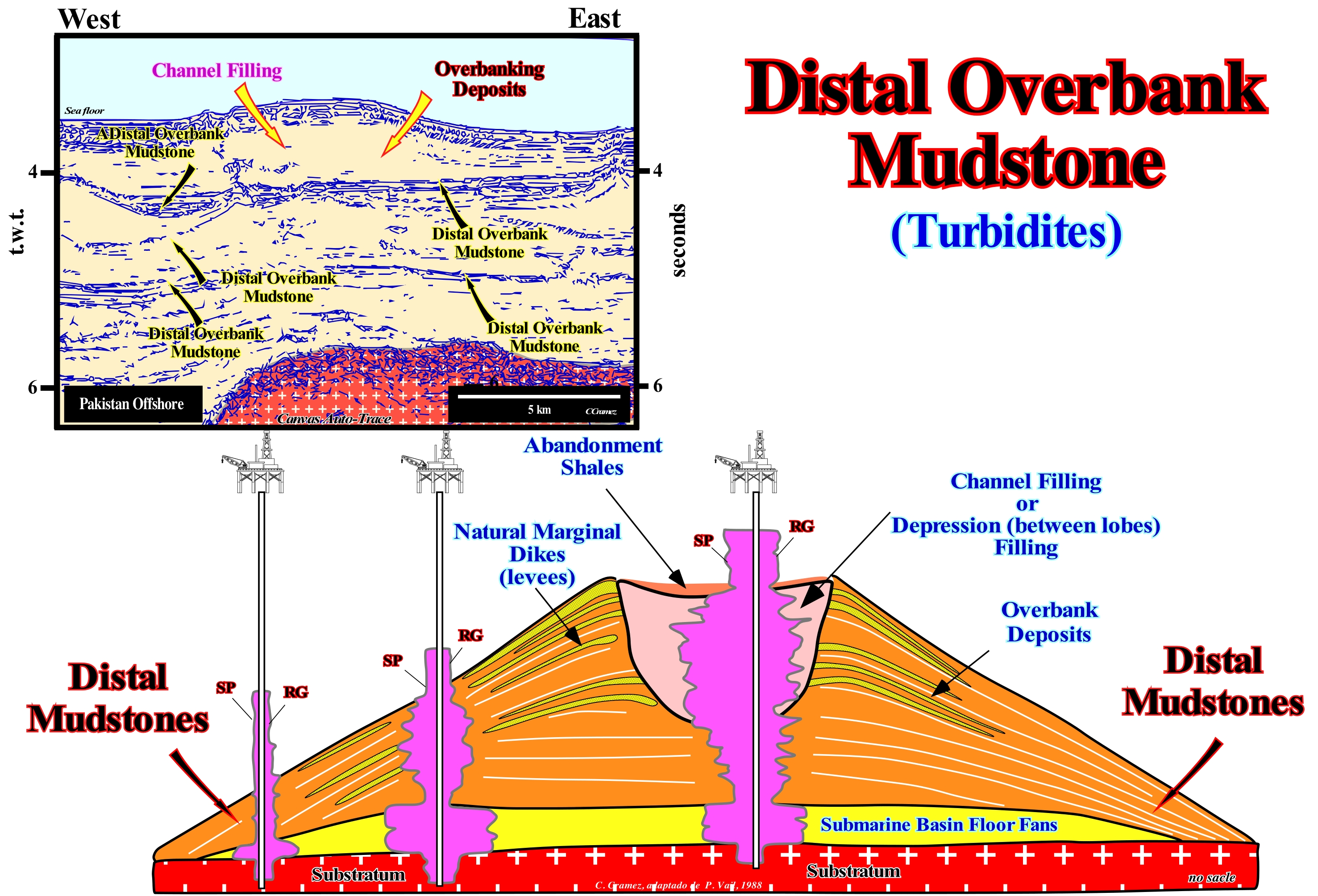
The term mudstone is here used to refer to a sedimentary rock composed of clay and mud, more or less, laminar, without fissility and, above all, not anchi-metamorphic (anchi-metamorphism is the first phase of metamorphism with recrystallization of the illite, for example). When a clay is compacted and acquires significant fissility, many geoscientists call it mudstone*. Distal overbank mudstone may be referred to as the distal clayey rock of the submarine slope fans (SSF) which terminates by downlaps (with opposite vergence) either on submarine basin floor fans (SBFF) or against the lower unconformity of the sequence-cycle to which the submarine basin floor fans belong. In fact, within a sequence-cycle, which is a stratigraphic cycle induced by a 3rd order eustatic cycle **, characterized by a time-duration between 0.5 My and 3-5 My, the submarine basin floor fans (SBFF) may be, completely, disconnected from the base of the continental slope and not be covered by submarine slope fans (SSF). They can be fossilized by the distal segments of the lowstand prograding wedge (LPW) progradations or even, in extreme cases, by the distal progradations of the highstand prograding wedge (HPW). As illustrated in this geological sketch, in most cases, distal overbank mudstones, as well as turbidite natural marginal dikes (levees), are not contemporaneous but older, than sediments filling the depression (or channel, when there is erosion). The depressions were used by the turbiditic currents that overflowing them deposited the sedimentary particles forming the turbiditic levees (natural marginal dikes). The facies (lithology and associated fauna) of the natural marginal dikes is, basically, shaly. The sand content is, generally, low and the thickness of the sandy horizons, rarely, reaches a meter, even in the thickest part, near the central depression. In very particular cases, the sand horizons can be considered as secondary reservoir-rocks. However, they may, slightly, increase the reserves of an oil field, but rarely alone, they form accumulations, economically, viable. When the sand levels of the turbiditic natural marginal dikes are saturated with petroleum, they correspond in most cases to resources (the amount of a mineral or an existing or undiscovered rock that may eventually be extracted, but which today can not be extracted for economic or technical reasons) and not reserves (part of the resources of a particular mineral or rock, such as oil, which can now be extracted from the land at a profit). The finer particles of overbank deposits are deposited farther away from the depression between the turbiditic natural marginal dikes. This, gradually, increasing the size of the depressions as the turbiditic currents overflow, may later (when the relative sea level rise) be filled in retrogradation either by sand (biconvex morphology after compaction) or by clay (convex/concave morphology), depending on the composition of the current. When the fill is sand, it forms rocks-reservoir, as is the case in the Angola deep offshore and Gulf of Mexico. Distal overbank mudstones, as illustrated in this figure, are well visible in the auto-trace of a Pakistan offshore seismic lines (divergent Atlantic-type margin overlying rift-type basins that lengthened the small Gondwana supercontinent before it fractured) in association with submarine slope fans cones, whose dimensions are, extremely, important, as illustrated in this figure. The seismic line of the Canvas auto-trace shown here is very distal (deep offshore with a water-depth of about 4 seconds t.w.t.). That is why not only the rift-type basins are not visible,but also the submarine slope fans rest, directly, under the volcanic crust (whether it is are sub-aerial or oceanic).
(*) For the great majority of the geoscientists, a shale is a fine grain clastic sedimentary rock composed of mud, that is, a mixture of clay mineral flakes and tiny fragments of other minerals, especially quartz and calcite (the proportion of clay to other minerals is variable), characterized by ruptures along thin slabs, parallel sheets or layers less than one centimetre thick, called fissility. The "mudstones", on the other hand, are similar in composition, but do not show fissility.
(**) An eustatic cycle is a wave-form of the relative sea level changes (bounded between two consecutive inflection points), which is constructed by combining the curve of absolute or eustatic sea level changes and tectonic variations (subsidence or uplift) which occurred during the same time period.
Distributary (Arm, fork)..............................................................................................................................................................Défluent (Distributaire)
Distributário, Distributivo / Canal distributario, Brazos / abzweigender Arme / 分流河道 / Рукав (реки) / Canale emissario /
Any of the numerous arms in which a river divides to reach its delta and the sea (or a lake).
See: « River »
&
« Delta »
&
« Water-course »
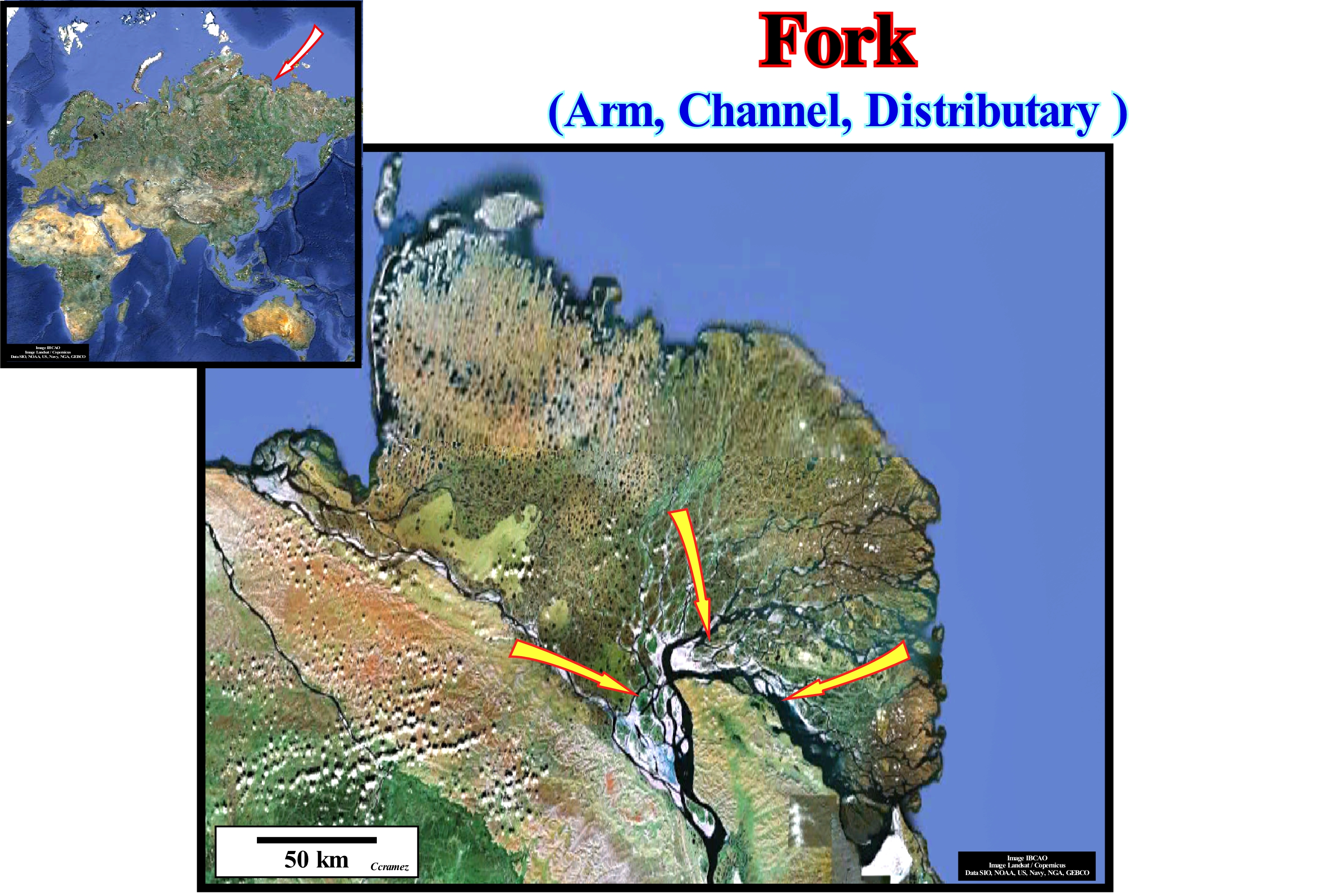
A distributary or distributive channel is a water-course, which branches out or flows outward of the main channel. This phenomenon is known as the river bifurcation. The distributaries, as illustrated in this figure, are very common in the deltas associated with rivers. The opposite of a distributary (or distributive) is a tributary or feeder of a river. Distributaries occur, usually, as streams near the lakes or the sea. They occur, also, on the onshore, such for instance, in closed or endorheic basins (closed drainage basin, which holds water and does not allow any flow to other water-body) or when a distributive current branches as it approaches the confluence with a more important current. In some cases, a smaller distributive can steal so much water from the main channel that it can become the main path of the current. The study of the deltas clearly shows that distributary channels control the flow of sediments into the ocean. A relationship exists, sometimes, between the number of distributary channels, the length of the river, and the delta gradient. These relationships are valid for deltas controlled or heavily influenced by sea-waves, discharge of rivers, tides or ice. Often, the distributaries of a delta result from the pendulum effect of the delta lobes, meaning that the currents are forced to move sideways as long as a lobe is formed. Naturally controlled deltas, in contrast to man-controlled deltas, such as the Klinaklini (Canada, British Columbia), have distributary channels, which act as over-banking sources during flood periods. Anthropogenically controlled deltas, such as the Po Delta, have distributary channels controlling the floods and, also, low runoff. Anthropogenic controls influence, strongly, the natural progradation rate of the delta induced by changes in the terrigeneous influx. They control the position of the distributary channels, but also the subsidence induced by the extraction of natural gas and groundwater. Even under these control conditions, the Po delta holds about 16% of the sedimentary particles carried by the distributaries, which rise at an annual rate of 4-10 cm in relation to the floodplain.
Distributary Channel................................................................................................................................................Chenal distributaire
Canal Distributivo / Canal distributivo / Verzweigtes Kanalsystem / 分流河道 / Дельтавидный рукав / Canale emissario /
Channel that starts at the highest point of a delta and transports the sedimentary particles that form the delta or any of the numerous arms in which a river divides to reach its delta and the sea (or a lake).
See: « River »
&
« Delta »
&
« Levee »
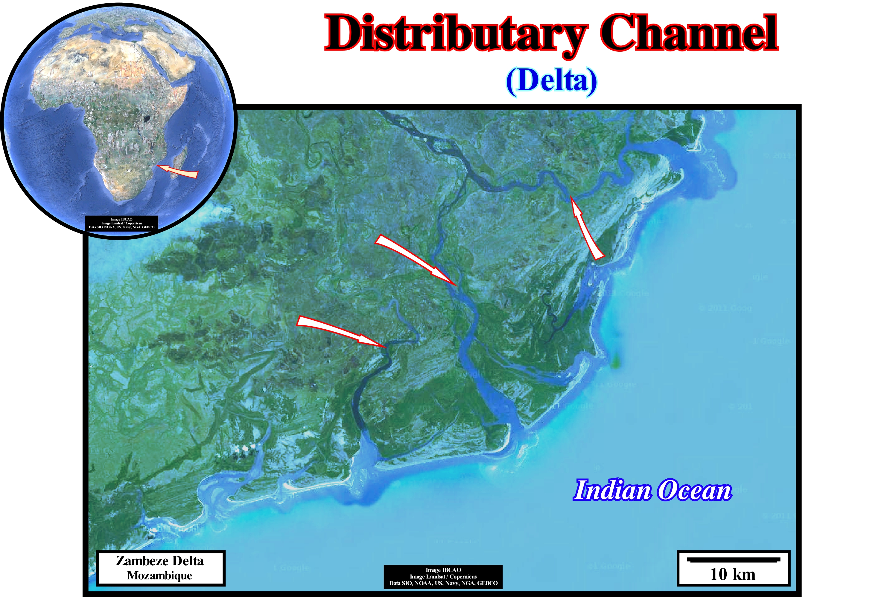
This photograph illustrates the distributary channels of the Zambezi River (Mozambique). It is along the distributary channels that the terrigeneous influx is transported seaward in order to construct a delta building, whose progradational geometry is determined by the deposit of the top-set, fore-set and bottom-set layers that form the deltas. It is important do not to forget that the geometry of a delta building (not confuse with the geometry of a delta, whose thickness varies between 10 and 60 meters) is, usually, a complex progradational. Within the delta building certain deltas have and oblique progradational geometries (without the top-set and, rarely, with bottom-set layers). Others have a sigmoid progradational geometry (with all three layers, i.e., top-set, fore-set and bottom-set layers). By definition, a distributary channel (depression through which the stream flows and not the filling of the depression) is an eroded sedimentary structure. It is carved into the, previously, deposited rive mouth-bar. In order that a delta building move seaward (progradation), the water-course has to open a path through the sediments that is deposited previously. The sedimentary particles liberated are carried downstream, where there is space available for them (accommodation) and will be deposited. The erosion induced by the distributary channels is, perfectly, visible in this figure. The continuity of the mouth-bars is, abruptly, interrupted by the distributary channels. In the fossil delta buildings or on seismic lines, the filling of the distributary channels underlines the incised action of the water-courses. The internal configuration of the fillings is much different of the internal configuration of the substrate pre-dating the incision. In sequential stratigraphy, when the incision of the distributary channels is important, it is used to localize the boundaries of the stratigraphic cycles. The incision (when significant) forms during a relative sea level falls, which is the main responsible (whether or not it is tectonically enhanced) between two consecutive stratigraphic cycles (sequence-cycle, continental encroachment subcycles, etc.).
Distributary-Mouth Bar....................................................................................................Barre d'embouchure (Distributaire)
Banco de desembocadura (distributivo) / Barra de desembocadura (distributario) / Nebenarm-Mund-Bar / 分流的嘴酒吧 / Бар в устье рукава дельты / Barra della bocca (distributore) /
Accumulation of gravel, sand, pebbles or other unconsolidated detrital material in elongated or lobular geometry rocky-body, deposited at the mouth of a river or at the mouth of distributary channel (distributive), when the deceleration of the water-course allows deposition. In general, due to the progradation of the delta, as the mouth bars are deposited, new distributive channels are formed, eroding the deposited bars.
See: « Delta »
&
« Delta Front »
&
« Systems Tract »
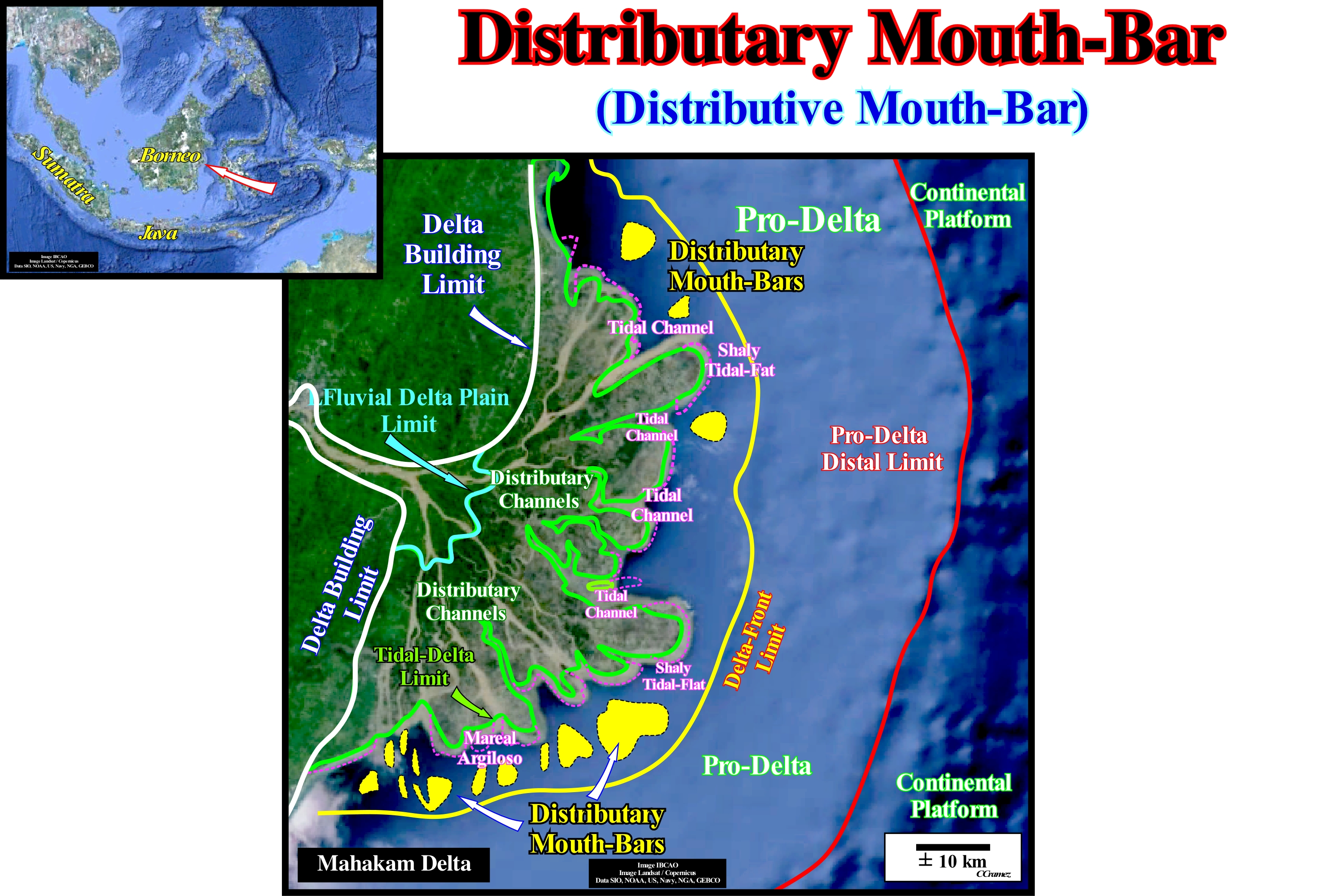
As illustrated in this figure, the Mahakam delta is located on the Eastern coast of Borneo Island (Indonesia), which for a geoscientist means that it formed within the Mesozoic/Cenozoic megasuture. Consequently, it was formed in a compressive geological setting in association with a marginal sea created after a small oceanic expansion induced by the break-up of a back-arc basin (episutural basin in Bally and Snelson basin classification). In these geological conditions, theoretically, i.e., a priori (Theory precedes Observation), the morphology of the marginal sea littoral must be characterized by a bay-line (line joining the points where the provisional equilibrium river profiles become horizon), very close or even coincident with the shoreline line. That implies a coastal wedge* poorly developed or even absent. In the actual delta, which is, basically, a tidal delta, it is easily recognized: (i) The fluvial delta plain ; (ii) The distributary channels ; (iii) Distributary mouth-bars ; (iv) The tidal channels and (v) The shaly tidal flats. As illustrated, the apex of the delta is perfectly controlled by the anticline structures that control the alignment of the coastline. The delta building has developed near the exit of the Mahakam River from the the mountains (folded belt). The coastal wedge (coastal prism), on the contrary, of what happens in most divergent Atlantic-type margins, is, practically, non-existent. The sediments deposited at the mouth of the tidal delta distributaries (mouth-bars of distributive channels) are, gradually, crossed by the distributaries that creates them as the delta progradate seaward. These deposits were used by certain geoscientists (who did not take into account the geological context and morphology of the area) to refute the importance or even existence of the bay-line. In sequential stratigraphy (Vail' school), the bay-line separates alluvial deposits** from the fluvial deposits. It corresponds to the locus (in the set of points of a surface that have a certain property) of the points where the provisional equilibrium profiles of the water-courses are adjusted, that is to say, the delta deposits occur when the water-course enter a water-body and the flow velocity decreases abruptly. According to the Vail school, which considers the coastal wedge, there must be an area of bays and lagoons along the coastline, with a gradual passage to the rivers upstream of that area. This appears to be the case in many areas of divergent Atlantic-type margins, but is not very common on non-Atlantic margins, as in the case of the eastern coast of Borneo. On this subject it is important to note that many geoscientists wonder how a delta can progradate seaward during stability period of relative sea level occurring after the marine ingression that created the space available for the sedimentation, if the sedimentary particles carried by the water-course are deposited in bays and lagoons, as admitted in the model of P. Vail. Opponents to the Vail' school think that the points where the provisional equilibrium profiles area readjust are the mouths of the water-courses and not the bay-line. Do not confuse the equilibrium line with the bay-line. The equilibrium line is the locus of the equilibrium points, i.e., the points where the accommodation created by subsidence and that created by the absolute or relative sea level are compensated. When the sea level (absolute or relative) rises, the equilibrium point moves upstream. When the sea level (absolute or relative) falls, the equilibrium point migrates downstream. The movements of the point of equilibrium are also influenced by the clastic sedimentary influx. P. Vail associates such sedimentary particles influx more to coastal currents than to the river currents. For him the great majority of the terrigeneous influx is deposited, immediately, downstream of the bay-line (coastal wedge), where the flow velocity decreases abruptly. The absolute (eustatic) sea level is the sea level, more or less, global, referenced to the Earth's centre. The relative sea level is the local sea level, referenced at any point of the terrestrial surface (base of the sediments, i.e., top of the continental crust or the sea floor). The relative sea level is the result of the combined action of absolute sea level and tectonics (subsidence or uplift of the sea floor).
(*) Set of the fluvial and marine deposits of shallow-water that accumulate in the coastal plain during the development of the coast line, which has the form of wedge and extends continentward by onlapping on the pre-existing topography.
(**) The term alluvial is here used, mainly, to designate alluvial fans in areas where the rivers leave the mountains due to loss of flow or transport capacity.
Divergent Filling (Seismic lines)..................................................................................................................Remplissage divergent
Preenchimento Divergente / Relleno divergente / Füllung divergieren / 发散填充 / Дивергентрое заполнение / Riempimento divergenti /
When the seismic reflectors, interpreted as strata, thicken laterally, basinward or in direction of the area with greater subsidence. On seismic lines, lateral thickening is, often, accompanied by a fission of the reflectors, which should not be interpreted as an unconformity fossilized by onlapping.
See: « Reflection Configuration »
&
« Subsidence »
&
« Relative Sea Level Change »
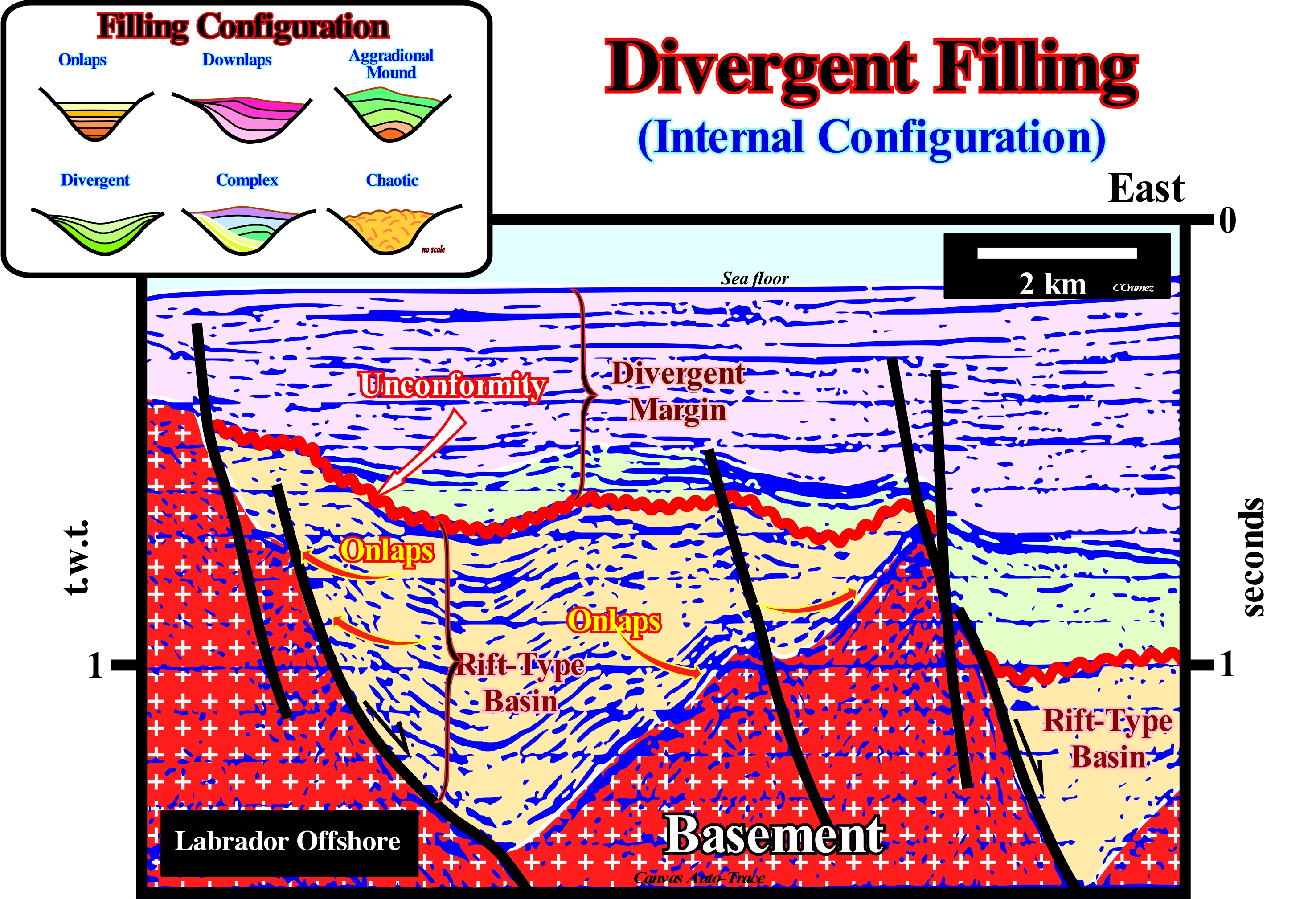
The Labrador offshore corresponds to the stacking of different basins in the Bally and Snelson (1980) sedimentary basin classification. On regional seismic lines from bottom to top, in this this offshore can be recognized: (i) A basement, which corresponds, generally, to pre-Cambrian supracrustal rocks, but which may locally correspond to a more or less, flattened Paleozoic mountain range ; (ii) Rift-like basins that lengthened the lithosphere of the Pangea supercontinent, and in particular of the small Laurasia supercontinent, before it broke-up and (iii) Divergent Atlantic-type margin, which is, mainly, made up of volcanic spills that initiate a subaerial volcanic expansion, before it becomes oceanic by sagging of the expansion centers, which are, usually, volcanoes. On this attempt to geologically interpret an auto-trace of a seismic line detail of this offshore, the geometry of the rift basins in halfgraben (geological structure bounded by a fault along one side of its boundaries, as opposed to a graben in the which the depressed faulted block is limited by parallel faults). Such a geometry emphasizes a differential subsidence *, which increases towards the faults responsible for the lithosphere lengthening the continental crust of the small supercontinent prior to the breakup of the lithosphere. For an elongation factor “β"> 4,5 (strain length that determines the amount of lithosphere that can be vertically thinned during an elongation episode), the lithosphere breaks down. The sediments, which fill the rift-type basins thickens towards the normal faults that bords the halfgraben structures, which often give a divergent geometry to the fill. Such a thickening suggests, strongly, the source of sedimentary influx is located to the west and the direction of the sedimentary transport is eastward. The proximal onlaps (upstream reflector terminations) have a westward vergence (or polarity), i.e., towards the mainland. In the same way , the distal onlaps have an eastward vergence toward the sea. The onlaps within the rift-type basins are, essentially, nonmarine. These basins, that is, in the basins formed before the lithosphere breakup of the Laurasia small supercontinent, are nonmarine, alluvial or fluvial and sometimes lacustrine. However, the internal configuration of the sedimentary intervals filling the rift-type basins depends on the ratio between the extension rate and the sedimentary sedimentation rate. When the lengthen of a basin is not compensated for by sedimentation, that is, when the space created for the sediment is not fully filled, a water-depth is formed and a more or less important lake, generally. develops within the basin. In this case, the fill geometry is parallel and not divergent, as illustrated in the western rift-type basin of this geological tentative. If the weather conditions are favorable, there is a strong likelihood that an oxygen-depleted zone will develop in the lower part of the lake of these basins, which will allow the preservation of the organic matter that has fall into the bottom and later the formation of lacustrine shales rich in organic matter, which are the main potential source-rocks of these basins. These rocks form the generating petroleum subsystem, as, for example, in the Cabinda onshore (Angola), which are, relatively, easy to highlight on the seismic lines, since they are associated with sedimentary intervals characterized bya parallel internal configuration. When the rate of extension of a rift-ltype basin is compensated by sedimentation, the geometry of the fill (total or partial) is divergent and the facies is mainly sandy, since the depositional water-depth is, practically always, zero. The formed available space is immediately filled since the sedimentation rate compensate the accommodation rate.
(*) Lithospheric elongation (differential subsidence) and isostatic compensation induce a thermal anomaly beneath the thin lithosphere (rise of the isotherms rise that form the limit the mantle of the asthenosphere). However since the thermal anomaly begins to cool down, the density increase pressures the lithosphere, causing a thermal subsidence. The thermal subsidence occurs exponentially and much slower than the fast differential subsidence as it attempts to maintain the isostatic equilibrium while the raised (heated) asthenosphere cools. The differential subsidence of the lithosphere ceases since the thermal subsidence begins.
Dolomitization.............................................................................................................................................................................................Dolomitisation
Dolomitização / Dolomitización / Dolomitization, Dolomitisierung / 白云石化 /Доломитизация / Dolomitizzazione /
Process by which limestones are totally or partially converted into dolomitic limestones by replacement of the original calcium carbonate (calcite) by magnesium carbonate (dolomite). This process is, usually, done through water charged with magnesium. Dolomitization may be synchronous or slightly posterior to sedimentation or may occur during lithification (diagenesis).
See: « Diagenesis »
&
« Limestone »
&
« Lithification »
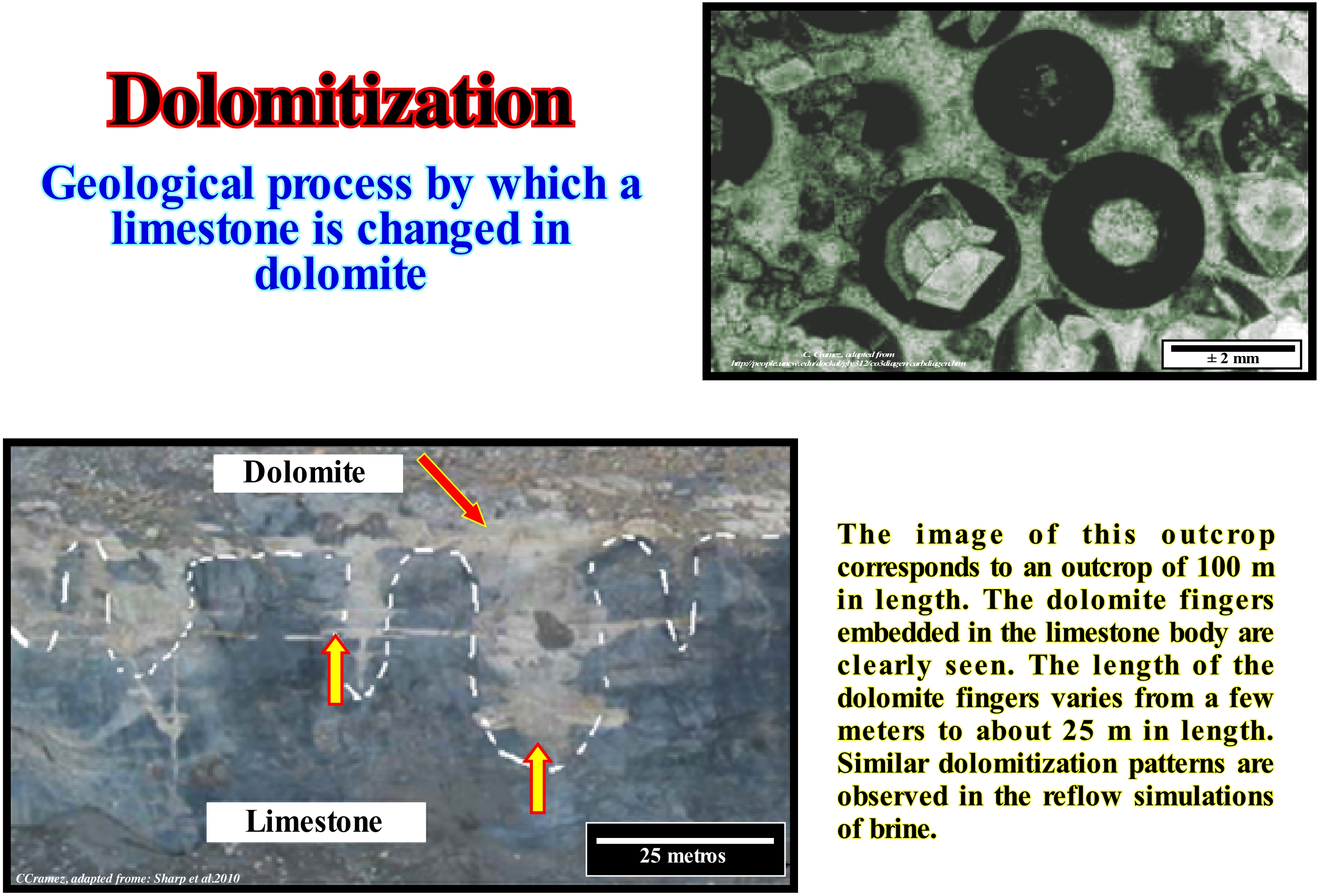
Dolomitization is a process by which a limestone is changed in dolomite (sedimentary organogenetic rock constituted by dolomite, calcite, with traces of clay, quartz, pyrite and marcassite). When a limestone is in contacted with a water rich in magnesium, the dolomite, calcium carbonate mineral and magnesium, CaMg (CO3)2, replaces calcite (calcium carbonate, CaCO3) in the rock, volume by volume. Dolomitization implies large-scale recrystallization. The dolomite (mineral) grains, which often show very distinct crystallographic faces, have, more or less, an uniform size that is smaller than the grains of calcite. When the recrystallization is not complete, the dolomite crystals are disseminated in a calcite matrix. Certain limestone rocks exhibit patches of dolomite (different colour), which geoscientists interpret as the result of local contamination by waters rich in magnesium. Dolomite stains which are totally independent of the stratification may also be the result of a simple separation from a crystalline mixture of calcium and magnesium carbonates as well as magnesium carbonate, i.e., a local precipitation of dolomite CaMg (CO3)2. Dolomitization is very common in supra-tidal sabkhas where magnesium ions resulting from evaporation of water replace calcium ions in calcite and form dolomite. As the volume of dolomite is lower than that of calcite a dolomitization implies a porosity increasing of, more or less, 13%. In this figure, the partial dolomitization of calcite is observed in a sample from the Cambrian-Ordovician of the Bears Island (Spitzberg). The ooids* were replaced by dolomite euhedral. In this thin section, the dolomite was colored with alizari red (trade name of the redhead root), which gives him, in black and white, darker shades.
(*) In geology, ooids are millimetric (usually less than 2 mm in diameter), spherical and non-biological grains that develop mainly in tropical and shallow waters. They are formed by successive crystallization of layers, usually composed of calcium carbonate, around a nucleus (calcite grain, skeletal fragment or shell, detritus grain). Crystals are usually arranged radially, but can also grow without following a particular geometry. A rock made up of ooids is called oolite. In some cases, the ooids may be composed of other minerals: hematite for iron oolites, chamosite (iron-rich chlorite), phosphate, etc. (https://fr.wikipedia.org/wiki/Ooïde).
Downlap............................................................................................................................................................................................Biseau de progradation
Bisel de progradação / Bisel de progradación / Downlap, Bevel Progradation, Progradierender Keil / Downlap, progradational楔 / Подошвенное прилегание / Downlap, Bisello di progradazione /
Geometric relationship associated with the lower limit of a stratigraphic cycle, in which the originally inclined strata or seismic reflectors terminate, downstream, against strata, originally, horizontal or less inclined. This type of geometric relationship, like all others, is defined in the primeval depositional position. Since the sedimentary intervals are tilted (shortened or elongated) all the geometric relationships that characterize the geometrical relationships become apparent.
See: « Downlap Surface »
&
« Marine Regression »
&
« Onlap »
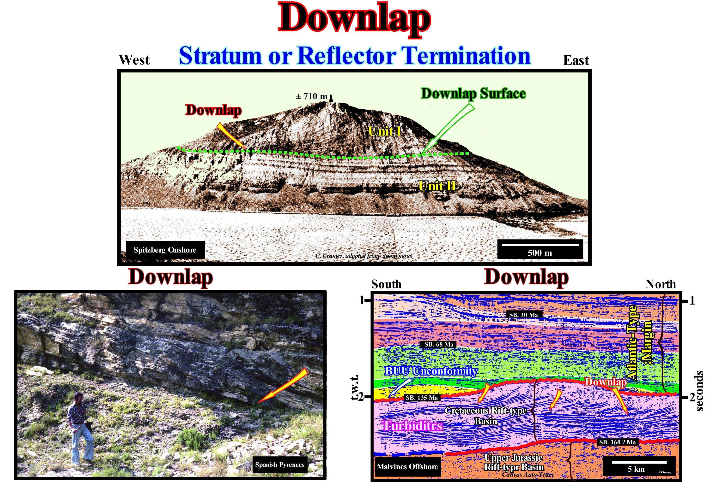
The mountain visible in the photograph (Spitzberg, Bears Island), illustrated in this figure, is constituted by two stratigraphic units. The lower (Unit II) of carbonate facies has a retrogradational geometry, that is to say, that the different intervals that compose it thicken slightly continentward (at the time of deposition), i.e., westward. Apparently, this corresponds to a global continentward shift of the deposition coastal break of the depositional surface which coincides, more or less, with the shoreline. This retrogradational unit consists of small regressive sedimentary intervals that overlap one another, but which, overall, create a retrogradational geometry. Each of these small regressive sedimentary intervals corresponds to a sequence-paracycle, which was deposited following a marine ingression. The space available for the sediments (accommodation), created by the relative sea level rise, which displaced the shoreline continentward, was, during the stability period of relative sea level occurring after each marine ingression, partially or totally, filled by the sediments. Such a deposition, progressively, displace, one again, the shoreline seaward, creating what the geoscientists call a sedimentary regression. This sequence of geological events can be summarized as follows: (i) A marine ingression, induced by relative sea level rise, creates the space required for deposition ; (ii) A period of stability of the relative sea level occurs after each marine ingression and deposition resumes creating a sedimentary regression as the shoreline moves seaward ; (iii) New marine ingression, but more important than the previous one ; (iv) New sedimentary regression, but less important than previous one ; (v) New marine ingression, etc., etc. Each relative sea level rise, i.e., each marine ingression causes a continental flood and the formation of a ravinment surface. The continentward displacement of the depositional coastal break of the depositional surface (more or less the shoreline) creates or increases the shelf extension, which, in general, decreases the terrigeneous influx (at least in relation to the extension of the platform continental). During the period of stability of relative sea-level stability following each of the eustatic paracycles, the shoreline, gradually, moves seaward as the sedimentary particles deposit by progradations (sedimentary regression). During successive regressions, the shoreline does not reach the old position that it had before the preceding relative sea level rise. It is the set of increasingly important marine ingressions and increasingly smaller sedimentary regressions (retrogradational geometry) that C. Emiliani called transgressions (not transgression, as many say). Since the relative sea level rise is smaller than the previous one (relative sea level rise in deceleration), during the stability period of the relative sea level, the shoreline moves seaward and goes beyond the old position, which it had at the end of the preceding sequence-paracycle. It is the beginning of the regressive unit (Unit I, in this photograph). This regressive interval corresponds to a succession of increasing regressions, induced by smaller and smaller marine ingression, which are responsible for the creation of available space for sediments. It is, more or less, the opposite of what happened during the deposition of Unit I, in which marine ingressions became increasingly important and sedimentary regressions became smaller and smaller. In this way, the sedimentary systems tracts deposited in association with the relative increases of decelerating sea level, progressively, fossilize the old continental platform by downlapping. This fossilization creates a downlap surface, which is clearly visible in this photograph, and which is by no means an unconformity. It does not correspond to an erosional surface, but to a surface characterized by having a deposition rate very small or even nonexistent. It corresponds to a surface along which the hiatus by non-deposition increases regularly seaward. When there is amalgamation of the distal deposits of a regressive interval, as illustrated in the tentative geological interpretation of a Canvas auto-trace of a seismic line from Malvinas offshore, one can not speak of the downlap surface but of a diachronic surface of the base of the continental slopes, which in this particular case, appear to be a stacking of delta slopes. In the photograph taken in the Spanish Pyrenees, the downlaps emphasize the progressive displacement of the sands of a point bar (meander) towards the central part of the bed of a river current.
Downlap Surface....................................................................................................................Surface de base des progradations
Superfície de base das progradações / Superficie de base de progradaciones / Grundfläche progradations / 下超面 / Поверхность регрессивного налегания / Superficie di base di progradations /
Surface associated with a condensed stratigraphic section and defined by downlaps. A downlap surface can limit different subgroups or groups of sedimentary systems tracts. Rocks rich in organic matter, (potential source-rocks) are, sometimes, deposite in association with this type of surface.
See: « Stratigraphic Cycle »
&
« Systems Tract »
&
« Maximum Flooding Surface »
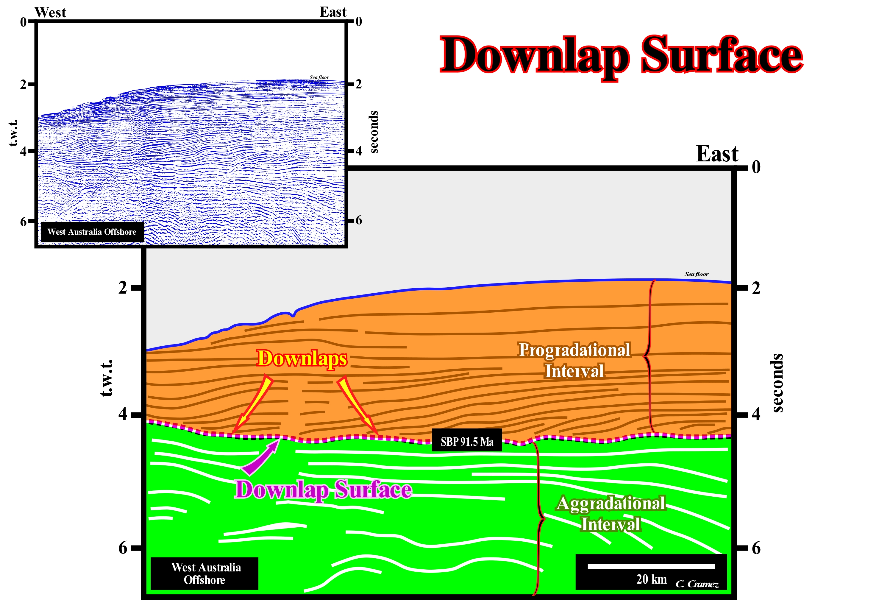
Within a stratigraphic cycle said sequence-cycle (induced by a 3rd order eustatic cycle, which is characterized by a time duration between 0.5 and 3/5 My), when the sequence-cycle is complete, three downlap surfaces can be observed: (i) Maximum flooding surface (MFS) ; (ii) The surface that is upper limit of the submarine basin floor fans (SBFF) and (iii) The surface that is the upper limit of the submarine slope fans (SSF). The first of these surfaces marks the boundary between the transgressive interval (TI) and the highstand prograding wedge (HPW), that is to say, that it separates the two subgroups of highstand systems tracts group. The second downlap surface separates the two lower subgroups from the lowstand systems tracts group, which means that it emphasizes the boundary between the submarine basin floor fans (SBFF) and the submarine slope fans (SSF). The third downlap surface, which is located, as well as, the second, downstream of the basin edge (which in this case is the last basin edge of the preceding sequence-cycle), marks the limit between the submarine slope fans (SSF) and lowstand prograding wedge (LPW). By definition, these surfaces separate aggradational sedimentary intervals (sometimes even retrogradational) from overlying progradational intervals. In this figure is illustrated a tentative geological interpretation of a Canvas auto-trace of a seismic line from the West Australia offshore , which, geologically, corresponds to the stacking of several basins of the classification of the sedimentary basins of Bally and Snelson (1980). In regional seismic lines the following sedimentary basins, from bottom to top, it is to recognized : (i) A basement that sometimes, locally, corresponds to a Paleozoic flattened folded belt ; (ii) Rift-type basins that lengthened the lithosphere of the small supercontinent Gondwana prior to its break-up ; (iii) A Mesozoic / Cenozoic divergent continental margin deposited in association with the 1st order post-Pangea eustatic cycle, in which an aggradational transgressive phase can be recognized at the base (green coloured interval in this tentative interpretation) and a progradational regressive phase in the upper part (coloured interval in orange). These two sedimentary phases are separated by a major downlap surface DS 91.5 Ma. In this tentative geological interpretation, it is easy to see that successive downlaps create a downlap surface, which is characterized by an increase hiatus (by no deposition) seaward. The downlap surfaces are developed during periods of highstand and lowstand The downlap surfaces associated with the first order eustatic cycles are called major downlap surfaces. During the Phanerozoic there are two main downlap surfaces surfaces that separate the transgressive and regressive phases of the two continental encroachment cycle, post-Protopangea and post-Pangea. Obviously, in this tentative interpretation, the aggradational and progradational intervals are those of the second continental encroachment cycle, that is to say, of the continental encroachment cycle associated with the breakup of the Pangea supercontinent (Mesozoic/Cenozoic). Also, secondary downlap surfaces may be considered when they refer to the continental encroachment subcycles, deposited in association with 2nd order eustatic cycles whose duration varies between 3/5 My and 50 My. Likewise, tertiary downlaps surfaces can be considered when they are defined within a sequence-cycle, i.e., associated with a 3rd order eustatic cycle, whose duration varies between 3/5 My and 0, 5 My. In sequential stratigraphy, in general, the downlap surfaces are not sequence boundaries. Although, in certain cases, they may coincide with them, such as when the progradations of a highstand prograding wedge (HPW) end, in deep water, directly on the correlative paraconformity of the lower unconformity that bounds the associated sequence-cycle. In genetic stratigraphy, at all hierarchical levels (eustatic cycles of 1st, 2nd, or 3rdorder), the downlap surfaces are always the boundaries between the transgressive and regressive packages*.
(*) It is preferable to speak of transgressive and regressive packages, which describe a retrogradational and a progradational morphology, rather than transgressions and regressions that are genetic terms associated with the order of magnitude of the eustatic cycles. For example, when geoscientist said that transgression is associated with a sea level rise and a regression to a sea level fall, this is true only at the level of the 1st order eustatic cycles, since it is the absolute or eustatic sea level which is taken into account. At the level of a 3rd order eustatic cycle, during a transgression or regression, the relative sea level is always rising. In the first case it rises in acceleration and in the second in deceleration.
Downward Current (Ebb tide, falling tide)..............................................Marée descendante, Reflux, Jusant
Vazante / Reflujo, Marea descendiente / Ebbe, fallend Wasser / 落潮 / Отлив (морской) / Marea discendente /
Part of a tidal cycle during which the level of the sea falls. Synonym with Low Tide, Ebb Tide and Falling Tide.
See: « Tide »
&
« Intertidal Beach »
&
« Shoreface »
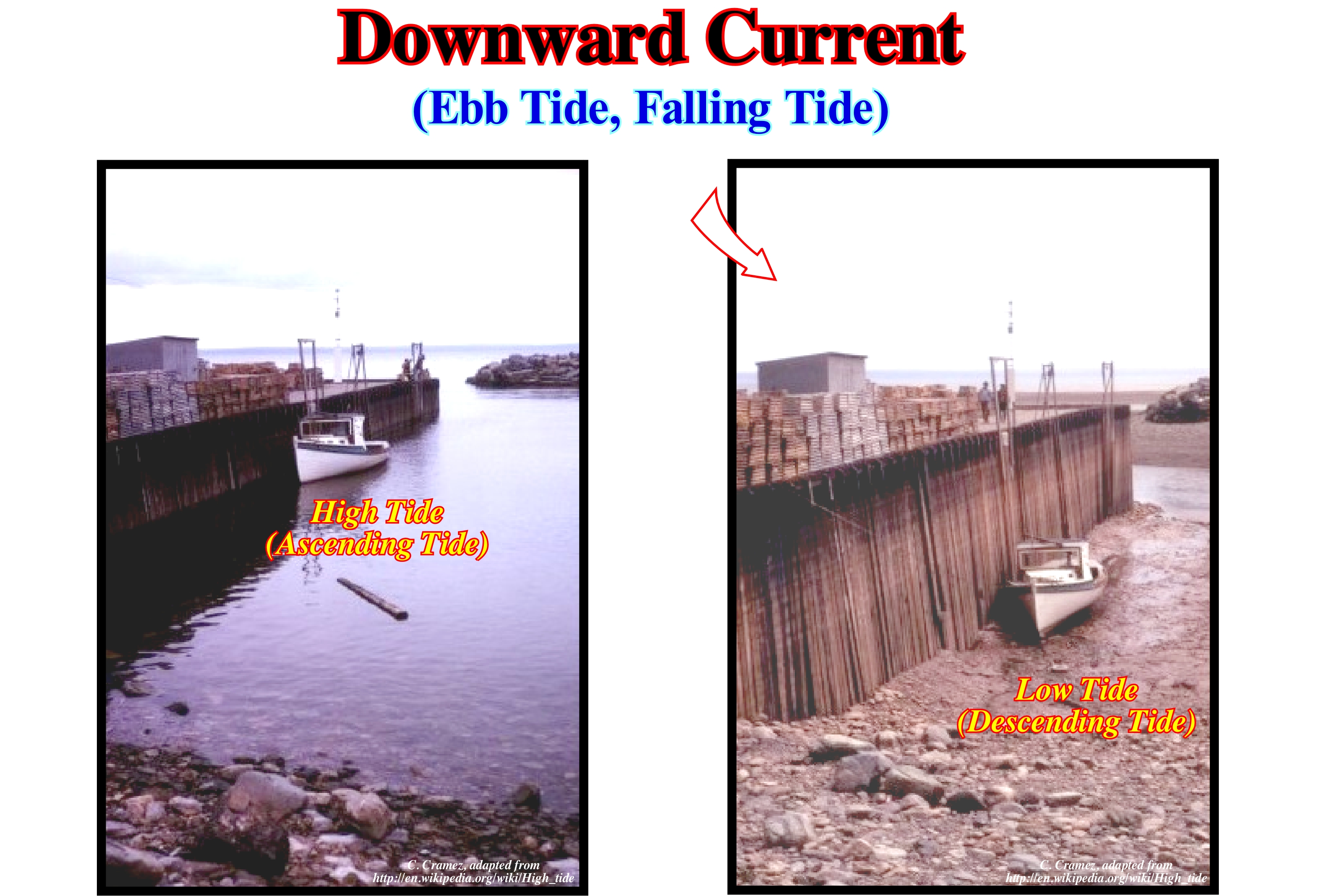
In these photographs, it is evident that at the maximum of the descending tide, that is, in the low-tide (ebb tide or falling tide), the boat rests on the bottom of the exhumed sea floor and that the whole height of the quay is visible which does not happen during the rising tide. The oscillation waves of oscillation of open sea formed by the lune-solar attraction, transform themselves into waves translation waves that give origin to the tidal currents. Being a translation wave (the water particles are displaced continentward), a tide, characterized by several parameters: (i) Tide Height, which is the difference between the levels reached between the high-tide and following low-tide ; (ii) Tide Amplitude , which is the half-difference of the levels reached between the high-tide and following low-tide ; (iii) Tidal Coefficient, which is the ratio between the tidal amplitude at a given time and in a given location and the average amplitude of the tide at that location ; (iv) High Water Full and Change, which is the time period that elapses between the time of high-tide and that of the Moon passage in the semi-meridian of the place ; (v) Slack Water, which is the moment immediately preceding the inversion of the tidal currents ; (vi) Phase Lag , which is the period of time that elapses between the time of the astronomical conjunction (syzygy) and the occurrence of the corresponding spring tide; in the astronomical conjunction, the Sun and the Moon seem close to each other when viewed from Earth ; (vii) Tide Period , which is the time elapsed between two consecutive high-tides or low-tides in the same place. In addition to the high and low-tides other types of tide are possible: a) Dynamic Tide, i.e., the tidal current that enters the estuaries (and deltas) upstream of the salt wedge penetration, due to the accumulation of fluvial waters pushed upstream of rising tide ; b) Neap tide, i.e., the tide that occurs during the lunar quadratures, being characterized, for each place, by minimum amplitudes ; c) Saline Tide, that is to say, the tide current that enters the mouths of the water-courses ; correspond to the advance of the salt wedge and of the brackish water mass resulting from the mixture ; d) Spring Tide, that is, the tide that occurs during the syzygies and is characterized, for each place, by the highest amplitudes; spring tides that occur near the equinoxes have maximum amplitude values ; are they call equinoctial tides.
Downwelling Current...............................................................................................................................................Courant descendant
Corrente Descendente / Corriente descendiente / Abwärtsgerichteten Strom / 下降流电流 / Нисходящий поток / Downwelling corrente, Corrente discendente /
Ocean current flowing downward, usually vertically, either due to the convergence of two opposite horizontal currents, or because it has a higher density (higher salinity, for instance) than the water in which it travels.
See: " Stream "
&
" Upwelling Current "
&
" Density Current "
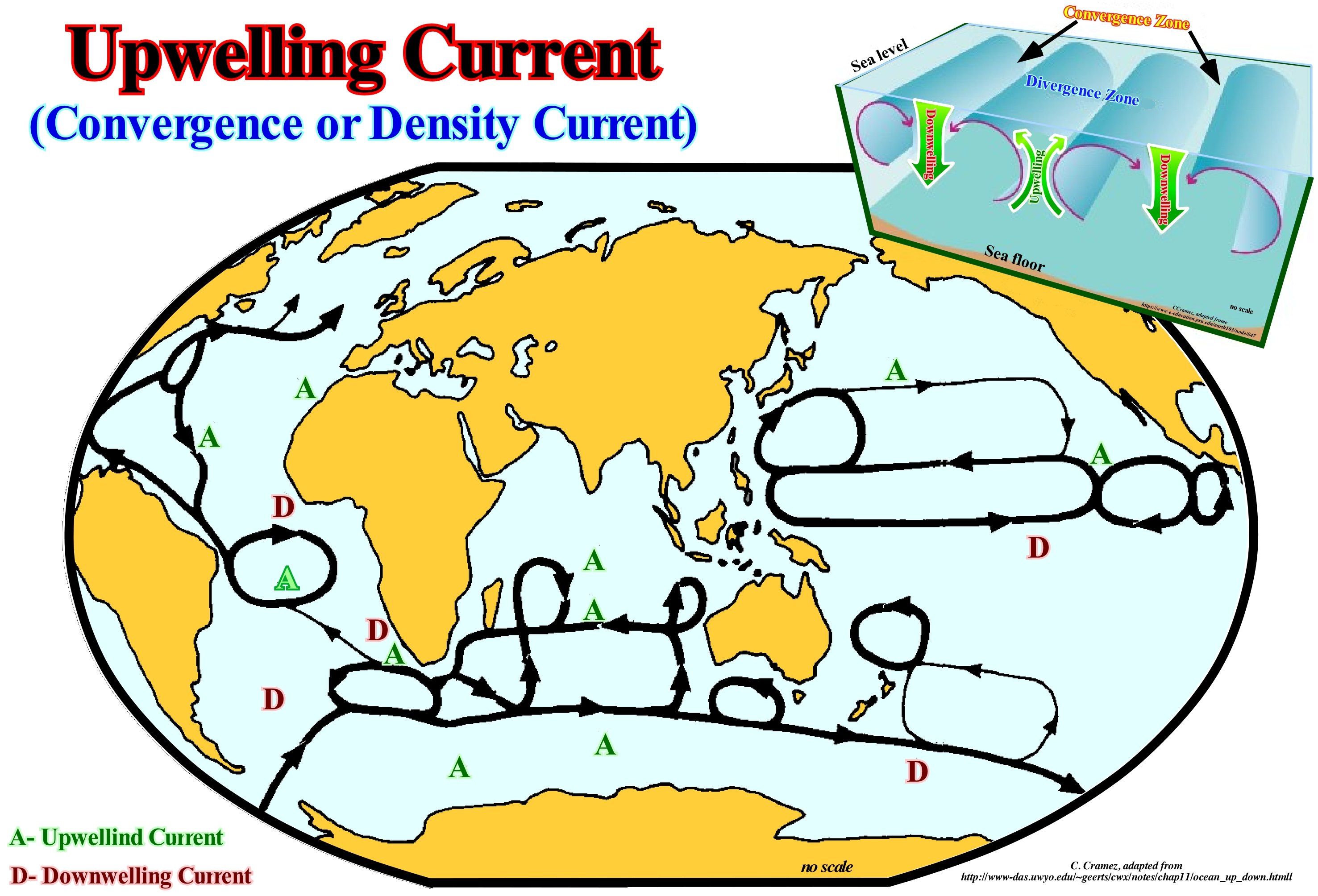
In this figure is represented the movement of the upper level of the oceans, that is to say, the level the above isotherm 3.5 ° C (or more correctly, above the potential line of temperature). The thicker lines underline the currents with a transport mass of higher than 20 x 109 kg/s, while the thinner lines underline the currents carrying between 10 and 20 x109 kg/s. The A letter indicates the position of the upwelling currents and the D letter of the downwelling currents. The understanding of the circulation of the oceans resulted from separated study of the surface and deep currents, even if the boundary between them is arbitrary. Such a division allows to calculate and compare the mass transported, that is to say, the water flow in the vertical plane perpendicular to the current in kg / s. The depth of the arbitrary boundary varies with latitude. It is about 2.2 km in the western part of the Pacific Ocean (equatorial) and 0 km near 65° N and 55° S. In the map illustrated in this figure, the arbitrary surface chosen was an is-entropic surface (same entropy). The currents rarely cross this type of surface (water, like air, conserves its potential temperature and flows along lines with the same entropy in the absence of a heat source). The entropy is the measure of the disorder of a system. Any reaction tends to occur, if in the reaction process the energy is degraded to a more dispersed and chaotic form (increase in entropy). As can be seen, on this map, one of the most important surface currents is the Antarctic circumpolar current. In South Australia and New Zealand, this current is convergent, which produces a downward current. The Antarctic convergence zone is a well defined line by the cold Antarctic water, which moves north and meets the warm waters of the oceans with low latitude. In calm weather, this convergence zone is underlined by a haze resulting from the cooling of the humid air coming from the North by the cold water coming from the South.
Draconic Period (Moon)......................................................................................................................Période dracronique (De la Lune)
Período dracónico / Período dracrónico (de la Luna) / Draconic Zeitraum / 交点周期 / Драконический период (Луна) / Periodo draconica /
Time span between two passes of an object in orbit by the same node (the point of intersection of its orbit and the ecliptic of the Earth). In the case of the Moon, the time span it takes to return to a node (starting from it) is smaller than orbital time or sidereal time*. This time span or draconic month is 27.212220 days). Synonym with Draconic Month.
See: « Sidereal Period (moon) »
&
« Synodic Period (moon) »
&
« Orbit »
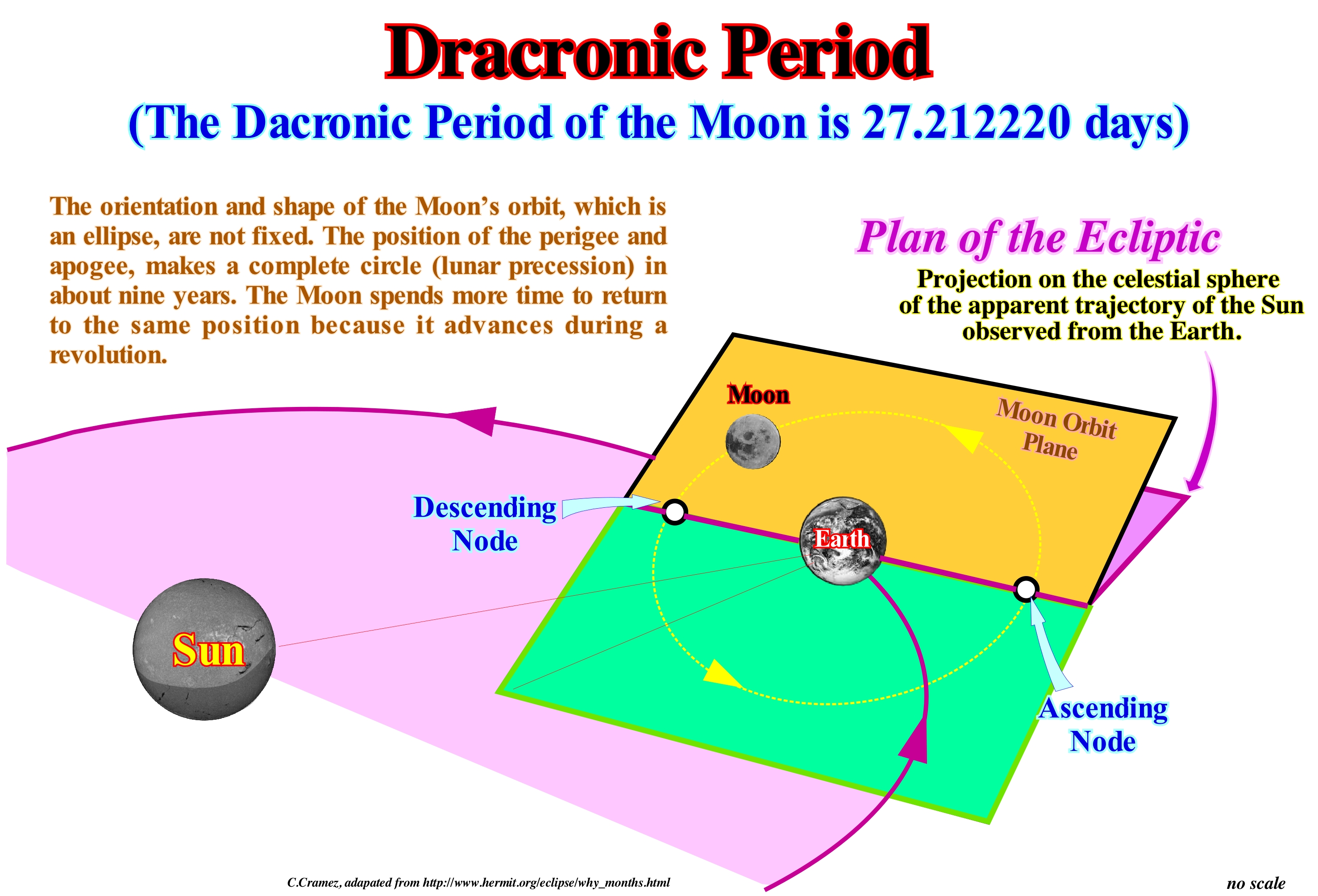
The Moon's orbit is tilted relative to the plane of the ecliptic. The points of intersection of the orbit and the ecliptic are the nodes (ascending and descending). The Moon to be, directly, in the alignment between the Earth and the Sun must be on the same plane of the ecliptic and on one of the two nodes. The time that the Moon spends to go from a node, along its orbit, and return is not, exactly, the same as a simple orbit due to the precession of the Moon's orbit. The plane of the Moon's orbit, as well as the nodes, rotate back around the Earth once every 18.6 years. The time the Moon spends to return to a node (starting from it) is smaller than the orbital period. It is this time is 27, 212220 dais and is called period or draconic month, that sometimes is called, simply, nodic month. Do not forget that beyond the draconic month there are other ways to consider how long it takes the Moon to complete an orbit: (i) Sidereal Month, which is the time the Moon takes to make a complete return to Earth in relation to the fixed stars, and which is about 27.3 days ; (ii) Synodic Month, which is the time spent by the Moon between two phases (for example, between two consecutive New Moons), which is about 29.5 days ; (iii) Tropic Month, which is the time between two consecutive phases of the Moon (same ecliptic longitude) ; (vi) Anomalistic Month, which is the time the Moon spends between two consecutive perigee positions. The synodic month is longer than the sidereal month because the Earth-Moon system shifts from a finite distance in its orbit around the Sun during each sidereal month, and thus it takes more time to find the same relative geometry. As a result of the slow precession of the Moon's orbit, the anomalistic, tropic, and draconic periods are slightly different from the sidereal month. The average time of a calendar month (1/12 of a year) is about 30.4 days.
(*) The orbital time for object in the solar systems is, generally, referred as sidereal time (implies that the considered object returns to the same position relatively to the fixed stars projected in the sky), which is determined by a 360° revolution.
Drainage Basin.............................................................................................................................................................................................Bassin versant
Bacia de drenagem / Cuenca de drenaje / Einzugsgebiet, Wasserscheide / 流域 / Дренажный бассейн / Bacino idrografico /
Total area, which provides water for a simple drainage system, i.e., the set of distributive rivers collecting and taking water to the sea, a lake or to any water-body.
See: « Basin (sedimentary) »
&
« River »
&
« Sediment Influx »
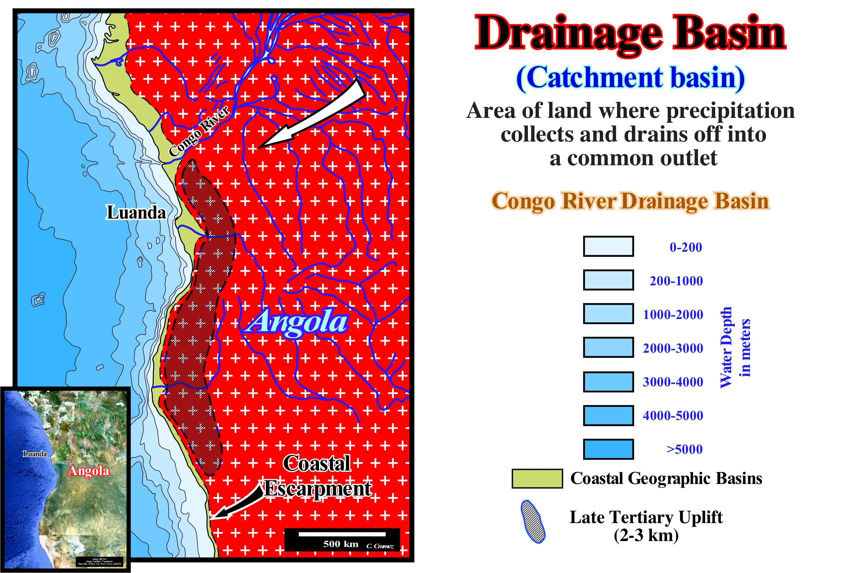
The drainage basin of the Congo river, shown here, is controlled by the coastal escarpment observed all along the Angola coast. This uplift, which occurred in the Late Tertiary, is very well visible in the conventional offshore seismic lines (water-depth less than 200 meters). The seafloor is characterized by toplaps by erosion (truncation), which allow to calculate a maximum uplift of about 1500-2000 meters. This uplift is corroborated by the vitrinite reflectance* of the organic matter of the source-rocks not only of the rift-type, but of infra-salt margin as well, which sometimes (onshore Cabinda) are less than 600 meters deep. With the exception of the Kwanza (in the central part of the map) and Cunene river (southern part of the map), which cross the area raised by narrow gorges, all other rivers flow continentward and form, in large part, the drainage of the Congo River, which reaches the sea northward of Angola's escarpment. This morphology explains, easily, why turbidite depositional systems (Oligocene and later) are frequent in the offshore of Congo and Cabinda and practically non-existent in the offshore of Angola (south of Ambriz, that is to say, in Kwanza offshore), which necessarily have implications in petroleum systems. At the petroleum point of view, almost all the oil fields are located north of the structural Ambriz Arch (where the basement reaches the coastline), which limits the geographic Congo basin (north) from the geographic Kwanza ( South). In the onshore of the geographic Kwanza basin, with the exception of the small Quenguela oil field (about 40 Mb), whose petroleum generating sub-system is very different from conventional system, all other accumulations found are noneconomic. The most likely reasons are the lack of good reservoir-rocks, such as those associated with the Late Tertiary turbidite systems in the offshore of the geographic Congo basin and the fact that the rift-type basin are too small and so filled, mainly, by sandy sediments. However, at the point of view of petroleum exploration, this onshore still is immature with respect to the infra-salt sediments, which may contain, locally, thick intervals with source-rocks characteristics, according to recent tentative geological interpretations of the new seismic lines (infrasalt margin depocenters).
(*) Vitrinite reflectance, referred to as % Ro, is a measure of the percentage of incident light reflected from the surface of vitrinite particles in a sedimentary rock. Oil and gas zone boundaries can be established using vitrinite reflectance data. The boundaries are approximate and vary according to kerogen type.
Drainage Density..................................................................................................................................................................Densité de drainage
Densidade de Drenagem / Densidad de drenaje / Flussdichte, Drainage Dichte / 排水密度 / Плотность речной сети / Densità di drenaggio /
Total length of the runoff channels divided by the drainage area. Indicates whether the drainage basin is well or poorly drained. The drainage density is expressed in km/km2. The drainage density is the inverse of a constant maintenance of the channels and equal to the reciprocal of twice the length of the surface flow.
See: " Drainage Basin "
&
" Stream "
&
« River »
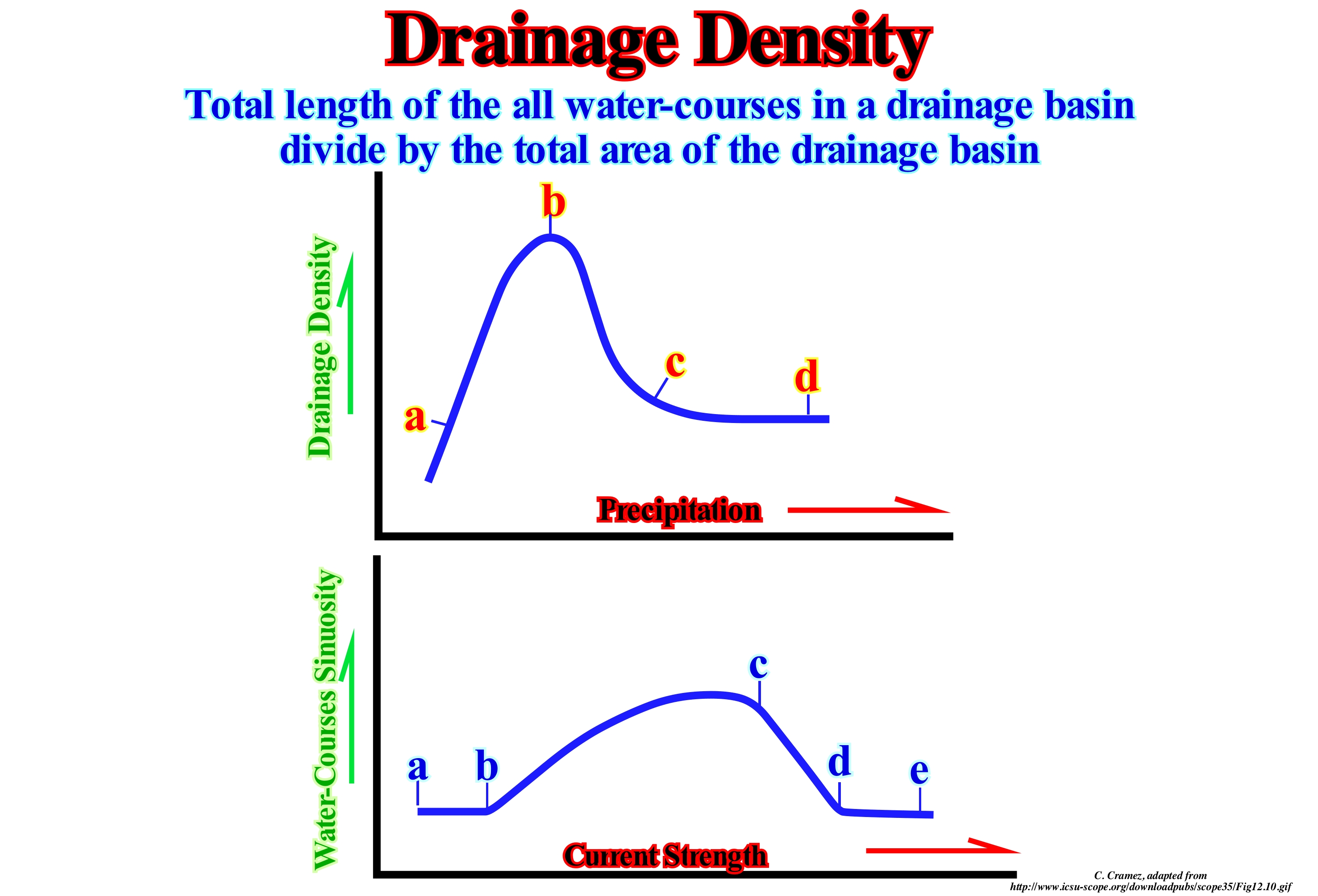
The drainage density (Dd) depends on the geology (structure and lithology), the topographical characteristics of the drainage basin and, to a certain extent, the climatic and anthropic conditions. In practice, drainage density values range from 3 to 4 for regions where the flow does reach a limited development and is centralized. They exceed 1000 to certain zones where the flow is very branched with little infiltration. Basins with poor drainage have a Dd < 0.5 km/km2 ; Basins with regular drainage have a Dd between 0.5 and 1.5 km/km2 ; Well drained basins have a Dd between 1.5 and 2.5 km/km2 ; Basins with very good drainage have a Dd between 2.5 and 3.5 km / km2 ; Exceptionally well drained basins have a Dd ≥ 3.5 km/km2. According to Schumm, the inverse value of drainage density, C = 1/Dd, is called stability constant of the water-course. Physically, it represents the surface of the basin needed to maintain stable hydrological conditions in a hydrographic vector unitary (section of the network). Sedimentary particle production and drainage density are highest in semi-arid regions. The same climate change has very different effects in the arid, semi-arid and humid regions. An increase in precipitation in an arid region increases drainage density and sedimentary particle export in that area. The same change in precipitation in a semi-arid region (increased vegetation cover) will produce less sedimentary particles and drainage density and decrease as vegetation eliminates drainage channels. Likewise, an increase in energy (increase in discharge or slope of the river valley base induced by a tectonic activity) may cause that a rectilinear flow change into a flow with a sinuous pattern, that a little meandering flow becomes a flow or may have no effect when the flow is braided or interlaced*. The same changes in energy or material introduced into the system can produce very different effects, which implies a good knowledge of the initial conditions before making extrapolations. The diagrams illustrated in this figure show how the drainage density or sedimentary particles production varies with the annual mean precipitation (upper scheme) and how sinuosity (channel length divided by valley length) varies with the energy of the flow (traction force multiplied by the flow velocity). With an increasing precipitation, the drainage density increases to a maximum (from a to b in the upper diagram), in the semi-arid regions, decreasing (b to c) and then remaining relatively constant (c to d) in the wet regions, when all other variables are the same. With an increase in current strength or velocity, the sinuosity remains constant with low values (from a to b), increases with meander formation (from b to c), decreases with the transition from meanders to braided rivers (from c to d ) and then is, more or less, constant, when the fluvial system is typically braided (from d to e).
(*) Flow without main channel, in which the presence of several relief causes the flow of the water to be divided into several courses of water that interlace (braided).
Drape.....................................................................................................................................................................................................................Drapé sédimentaire
Envelope pelágico (tapete sedimentar) / Envolvente pelágico / Envelope (Umschlag) pelagischen / 沉积披覆 / Осадочная складка / Drappo sedimentario /
A relatively thin sedimentary envelope composed of pelagic clayey rocks deposited between the systems tracts or sets of systems tracts, whenever the deposition centers move mainland. Such a displacement creates, in the distal parts of the shelf and in deep-water, geological conditions characterized by a very low sedimentation rate. In submarine slope fans (SSF), above the fillings of the depressions (between lobes) and overbank deposits, the pelagic envelope is, particularly, thick, although, almost always, under seismic resolution.
See: « Stratigraphic Cycle »
&
« Slope Fan (submarine) »
&
« Transgressive Interval »
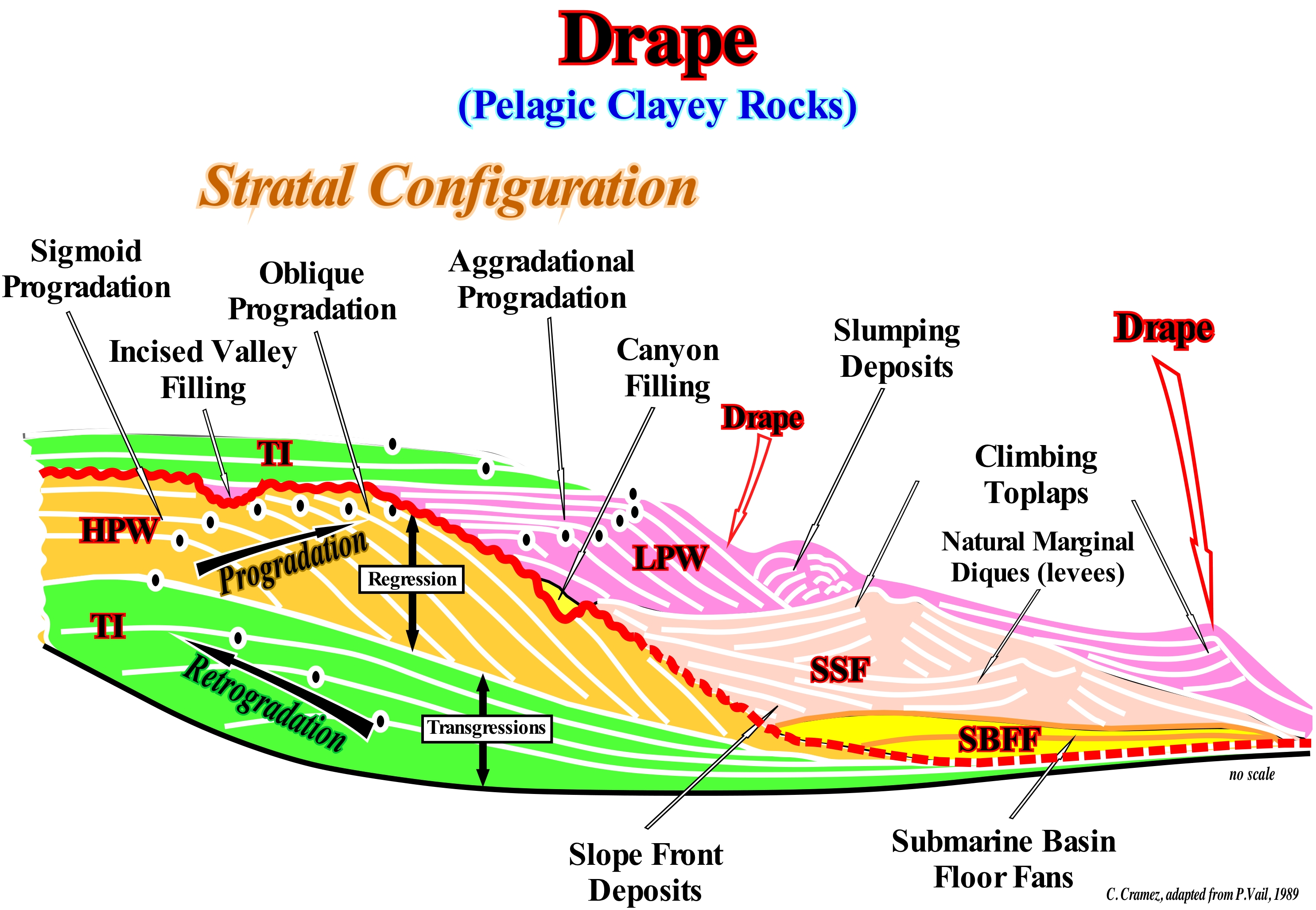
In deep-water, at the hierarchical level of the sequence-cycle, the drape (pelagic envelope) between the systems tracts sub-groups of lowstand systems tract group (LSTG) and the transgressive interval (TI), which is underlined in this figure (upper sequence-cyle) is often, thinner than the resolution of the seismic lines. Its thickness, rarely, reaches 20/30 meters. The drape layers exist almost always, not only, among the three systems tracts subgroups of the lowstand systems tract group, that is, between: (i) Submarine basin floor fans (SBFF) ; (ii) Submarine slope fans (SSF) and (iii) Lowstand prograding wedge (LPW), but also between each turbidite lobe. Drape layers have a very low sedimentation rate, whereas the other rocks, which form the deposition systems of the sedimentary systems tract, have much higher deposition rates*. This means that the time of deposition of a drape is much longer than the time of total deposition of the rocks between it. A turbidite layer of a submarine basin floor fan deposits in a few hours, while the pelagic layer (drape),that fossilizes it, is deposited in several thousands of years. It rarely exceeds 5-10 centimeters thick. Imagine a stratigraphic interval composed of 100 turbidite layers and pelagic layers. Each turbidite layer has a thickness of 100 cm and each pelagic layer has a thickness of 5 cm. The total thickness is 15,000 cm. As the deposition rate of pelagic argillites is ± 5 cm/1000 years and the Turbidite currents are instantaneous stratigraphic events, we can deduce that: a) Total deposition time is 100,000 years ; b) The frequency of turbidite currents one each 1,000 years ; c) Two-thirds of the sedimentary interval were deposited by instantaneous events, whose frequency is one event every 1,000 years ; d) In 10 million years, 10,000 instantaneous events (in geological terms) can deposit a section of 15,000 cm thick. However, globally, it can be said that both deposits are part of a sedimentary interval (submarine basin floor fans of a sequence-cycle), that in the Sequential Stratigraphy, is deposited, practically, of instantaneous way. In fact, within the Phanerozoic (time interval with interest for the petroleum geology), which lasted for about 600 million years, the whole geological events ** with a time-duration equivalent to 1/100 of the total time of the Phanerozoic, that is to say, an event that lasted 6 My is considered, at least, at the mathematical point of view, as an instantaneous. Actually, there is no easy way to represent it graphically. If the Phanerozoic is represented by a line of 15 cm in length, an event with a time duration of 6 My, i.e., an instantaneous event will correspond, at the same scale, practically, to the thickness of the line (0.15 cm). In this sketch, two incomplete sequence-cycles are shown. They were induced by two 3rd order eustatic cycles, whose time duration varies between 0.5 and 3-5 My, which are separated by an unconformity induced by a fall of the relative sea level (sea level, local, referenced to any point on the land surface, which may be the sea floor or the base of the sediments). In the lower sequence-cycle, only the transgressive interval (TI) and the highstand prograding wedge (HPW) are represented. The former has a retrogradational geometry. It corresponds to increasingly important marine ingressions and increasingly smaller sedimentary regressions, that, collectively, geoscientists call transgressions. The second has a progradational geometry (increasingly smaller marine ingressions and increasing important sedimentary regressions). The upper sequence-cycle is represented by the transgressive interval (TI) and by the lowstand systems tracts group (LSTG) in which the three sub-groups were deposited: (i) Submarine basin floor fans (SBFF) ; (ii) Submarine slope fans (SSF) and (iii) Lowstand prograding wedge (LPW).
(*) A lamination of a beach deposit is deposited in about one second. A layer of HCA ("Hummocky Cross- Stratification) characteristic of storm deposits, is deposited in minutes. A turbidite layer is deposited in a few hours. Flood deposits, such as the Canadian Scablands (deposits and erosions associated with flooding caused by the rupture of the retention of the lakes behind the Plio-Pleistocene glaciers) deposited in a few weeks. Glacial varves are deposited during a year. One centimetre of pelagic sediments deposits in about 103 years. A continental encroachment sub-cycle deposits in 10-20 x106 years ; A continental encroachment cycle is deposited in 100-200 x 106 years.
(**) The term event, which is, often, heard at meetings of oil companies, obliges us to insist on its meaning. Geological agents are rare and episodic, on a human scale. They induce punctual changes that, on a geological scale, are more or less continuous processes. Mathematically, an episodic geological event is characterized by a time-duration that rarely exceeds 1/100 of the total time considered. In other words, when expressed graphically, an episodic geological event (change over time) is only the thickness of a pencil's trace.
Drift Deposit.....................................................................................................................................................................Dépôt fluvio-glaciare (Côte)
Depósito fluvioglaciário / Depósito fluvioglaciar / Glaziofluvialer Anzahlung (auf dieser Seite) / 冰水存款(边) / Флювиогляциальное отложение / Depositi fluvioglaciali (costa) /
Geological body deposited in a lake, ocean or river as a direct consequence of glacial activity.
See: « Glacio-Eustasy »
&
« Outwash Fan »
&
« Depositional Environment »
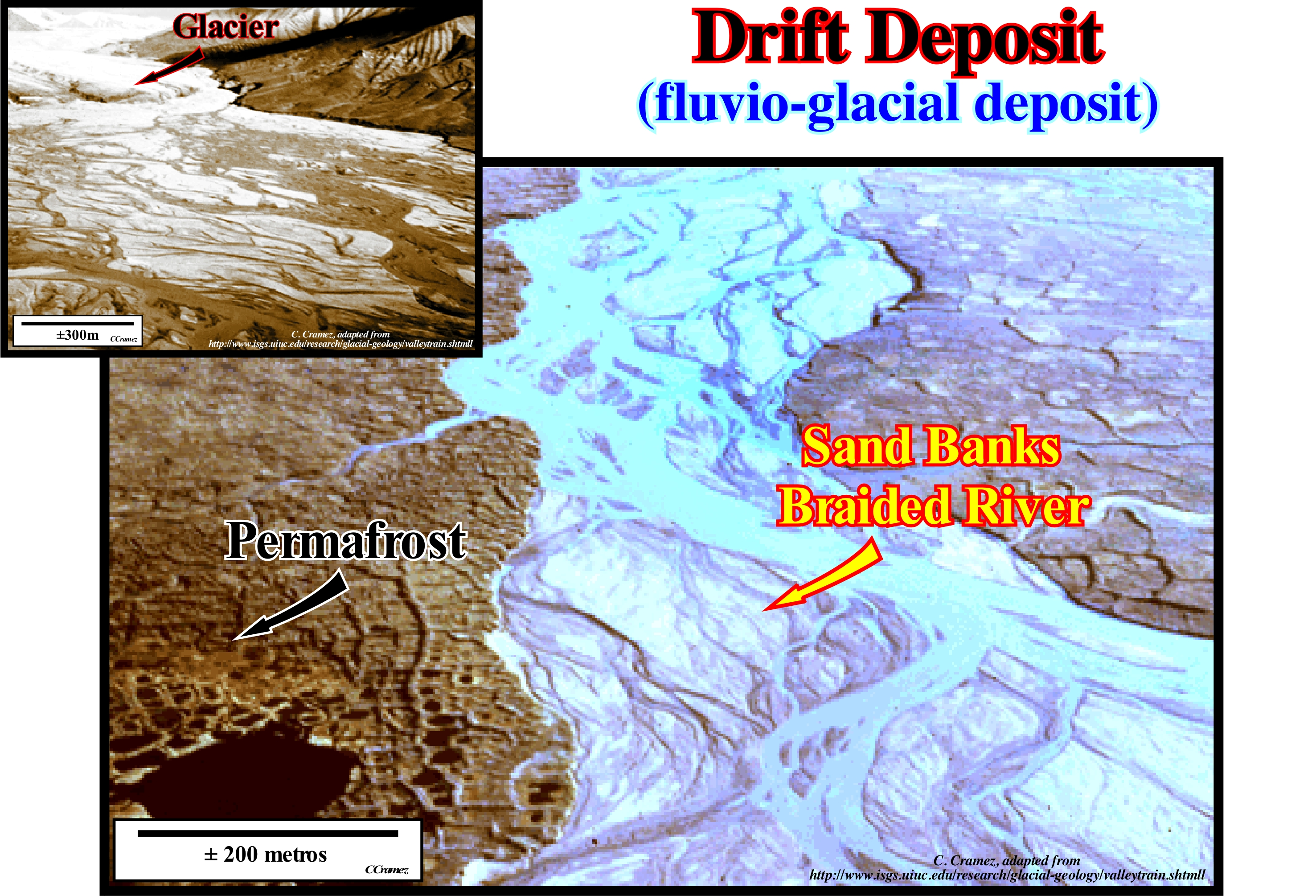
The pro-glacial margin is the area, immediately, situated at the head of a glacier. It is influenced by glacial, gravitational, fluvio-glacial and glacial-lacustrine processes. In the Alps, the active pro-glacial margin is limited by the moraines formed during the Little Ice Age, i.e., during the 19th century (± 1850), whose surface is, currently, increasing due to the thinning of the glaciers. Geoscientists speak of fluvio-glacial processes when glacial deposits are remodelled by the thaw. The margin sector remodelled by these processes is what the Icelandic geoscientists called "sandur". It is a great fluvio-glacial accumulation plain situated downstream of a glacier, which may occupy all or part of the glacial margin. In the polar regions, sandur is, generally, very extensive. In alpine areas it can be reduced to a few hundred square meters. Due to variations in the flow of the pro-glacial waters and the large amount of material that can be mobilized, the tracing of water currents in the sandur is, generally, braided or interlaced. However, glacier retrogradation, induced by its thinning and/or due to changes in flow and volume of sediments, the sandur can be incised , which implies the formation of terraces. The same happens more downstream, that is, in the valleys, where the initial post-glacial filling is, generally, eroded, to later, to form a fluvio-glacial terrace, lower than the bed of the water currents and in relation to the alluvial terraces nestled on fluvio-glacial terraces (http://www.unifr.ch/geoscience/geographie/ssgmfiches/glacier/2302.php). All the fragments and particles of rocks (clay, silt, gravel sand, blocks, etc.) transported by a glacier and deposited, directly, by the ice or by the water currents formed due to the melting of the glacier are fluvio-glacial deposits. These deposits include all non-stratified sediments which form: (i) The moraines (deposits of material of a glacier, which are exposed, particularly, as long as the glacier becomes thinner) ; and (ii) The stratified deposits which constitute the fluvio-glacial plains, i.e.: ii.a) "Eskers" (long and sinuous strings of stratified sand and gravel) ; iib) "Kames" (mounds of sand, gravel and lime, i.e., no-worked and non-layered sediments deposited directly by or under a glacier and which are not reactivated by the melting water) with irregular shape accumulating in the depressions when the glacier is retrograding ; iic) "Drumlins", which are, generally, found in the lower part of the glacial valleys and are small mounds with a whale-like geometry (they correspond to small sized middle-moraines deposited during a short stagnation period of the glacier, when tit is thinning, or to deposits that filled a large groove along the glacier, created by one river on the surface of the glacier) ; iid) Varves (layers of sediment or sedimentary rock deposited during a year), etc. In this photograph, taken downstream of a glacier on the island of Bylot (off the northern end of Baffin Island, in the territory of Nuavutm, Canada), the fluvio-glacial sediments, mainly gravel and sand, resulting from the erosion of the granitic supracrustal rocks, that form this region of the Canadian shield, were deposited in braided bars. In the smallest picture (upper left corner of the figure), the tongue of a glacier is, still, perfectly visible, as are the sand and gravel bars, which form a system of braided (or anastomosed) channels. In the larger photograph, taken further downstream, the braided channels are sharper and the pattern, observed below and at the left, is the result of frost and thawing of an active layer in the permafrost zone. In geology, the permafrost is a soil that is at freezing temperature, or even at a lower temperature, for a period of at least two years. Ice is not always present as is often the case when the substratum is not porous. But it is, in general, present and can exist in quantities that exceed the hydraulic saturation potential of the terrain. Permafrosts are located at high latitudes near the North and South Pole but may also exist at high altitudes in low latitude areas, such as in the Alpine regions. Deposits of glacial material (erosion, transport and deposition by glaciers), including sediments and erratic blocks, found anywhere on earth or at sea are called drift deposits.
Dropstone....................................................................................................................................................................................................Claste glaciomarin
Clasto glaciomarinho / Clasto glaci-marino / Clast glaziomarinen / 碎屑冰海 / Сталактитовая разновидность кальцита / Dropstone /
Glacial dropstone are large fragment of rock deposited in the middle of fine sediments on the sea floor or at the bottom of a pro-glacial lake. Initially, it can be transported by an iceberg before it fell from it during the thaw.
See: " Iceberg "
&
" Erratic Block "
&
" Differential Compaction "
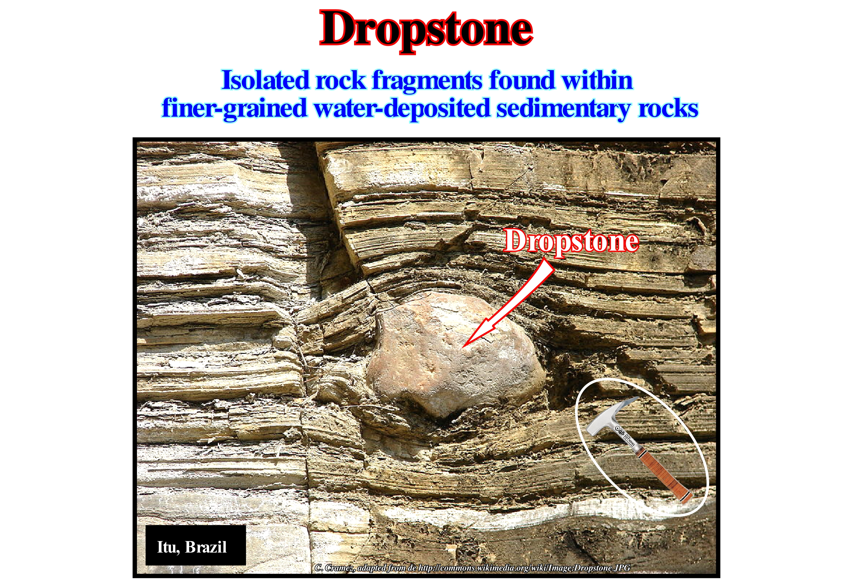
This photograph illustrates a clastic dropstone of quartzite in the midst of fluvio-glacial deposits. On the surface of the clast, the effect of the abrasion (erosion that fragments transported by a glacier suffer and produce when they scrape the rocks of the substrate) caused by the movement of the glacier is noticed. Equally, it is interesting to note the effects of differential compaction between the clast and the fluvio-glacial sediments in the middle of which it is found (the sediments are more compacted above and below the clast). The sediment compaction rate is, easy, to calculate since the clast, not practically compactable, gives, approximately, the original thickness of the sediments prior to compaction. Glacio-marine clasts are part of a large family of rocky blocks that the geoscientists call erratic blocks (dropstones). They are deposited in sedimentary environments where they, normally, should not be found. In general, erratic blocks or fallen blocks (dropstones) can be carried by four different means of transport: (i) Glaciers, as they melt and deposit the fragments they carry; the same is true of the icebergs which, from the moment they enter the sea, gradually, begin to melt, and drop all the rocky fragments they carried to the bottom of the sea, far from the shore ; (ii) Volcanoes, during the explosions not only volcanic bombs, but also fragments of other rocks can fly for kilometers and thus incorporate in the middle of totally different sediments ; (iii) Turbiditic Currents, that carry to the deepest parts of the sedimentary basins, fragments and blocks torn from both the basin edge and the walls of the canyons where they often pass and (iv) Biological Rafts, those formed by plant remains, which generally form during periods of flooding, particularly in forests, and which can carry significant rock fragments over hundreds of thousands of kilometers, and then drop them to the bottom of the sea.
Drowned Shelf...........................................................................................................................................Plate-forme carbonatée noyée
Plataforma carbonatada morta / Plataforma carbonática ahogada / Drowned Karbonatplattform / 淹没的碳酸盐台地 / Затопленная карбонатная платформа / Piattaforma carbonatica annegata /
When a relative sea level rise puts a carbonated platform under a water-depth higher than the depth of the photic zone. Under such conditions, the production of carbonate material ceases and the platform dies (drowned as certain geoscientists say). Just pelagic mud can be deposited on the carbonate platform.
See: « Shelf »
&
« Transgressive Interval »
&
« Photic Zone »
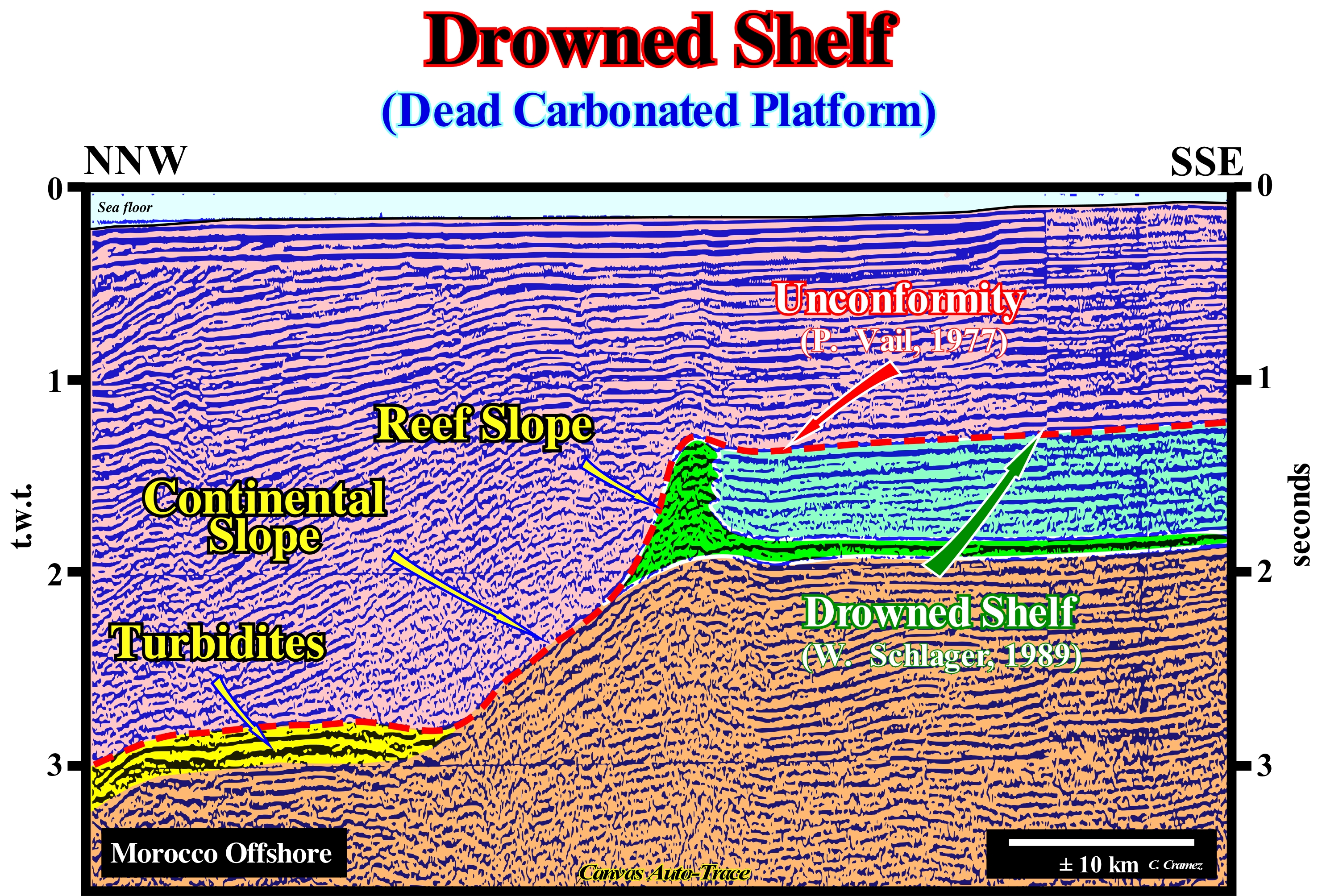
A continental shelf, whose depth varies between 0 and 200 meters, is a physiographic province, which is part of the continental margin morphological structure (submarine extension of the continental block) while a carbonated platform is a sedimentary body that has a topographic relief and which is composed of calcareous deposits that have formed "in situ", that is, an autochthone calcareous deposits. Under normal geological conditions, the water depth of a limestone platform can not exceed the photic zone depth. Otherwise carbonate formation can not occur (photosynthesis). A carbonated platform may coincide with a continental shelf, but, in general, this seems to be an exception. Carbonate intervals of shallow water are what most geoscientists call carbonate platforms, which are very sensitive and affected by relative sea level changes. Most geoscientists consider five categories of carbonate platforms: A) Rimmed Platforms, which are characterized by the presence of reefs or shoal limestone sands (carbonated sandbank covered by shallow sea water) on the platform edge and shaly sands in the lagoon or open platform ; this platform type forms in calm waters and its extension varies between 10 and 100 km. B) Ramp Platforms, in which the carbonated coastal sands pass, at the base of the ramp, to shaly sands and deep water mud ; in this type of platform, reefs are rare and the ramp width can reach 100 km. C) Epiric or (epeiral) platforms, which are characterized by the presence of tidal surfaces and protected lagoons ; the width of an epiric platform can reach 10,000 km. D) Isolated Platforms, in which the facies (lithologies) are very controlled by the orientation of the dominant winds ; these platforms have reefs and sandy bodies, such as the rimmed platforms, in the windward margin (facing the side where the wind blows) ; in the leeward margin ( direction where the wind blows), the sediments are more muddy ; an isolated platform can reach 100 km wide. E) Drowned or dead platforms, when they are under the photic zone (where there is not enough light for photosynthesis, i.e.,to use of carbon dioxide (CO2), and water to obtain glucose through the energy of sunlight). The better known carbonate platform geometry is associated with tropical manufacturing processes. Carbonate platforms can be sub-divided into three main sedimentary environments: A) Reef, which is the part of the carbonate platform created in situ by sessile organisms ; B) Internal lagoon (part of the platform behind the reef, which is characterized by shallow and calm waters with sediments composed of fragments of reefs and hard parts of organisms or terrigeneous sediments when the reef is epicontinental) and C) Slope, which connects the reef to the basin and acts as a sink for the excess carbonate sediment ; most of the sediments produced in the lagoon and in the reef are transported, by various processes, are accumulated on the slope. On this tentative geological interpretation of a Canvas auto-trace of a Morocco offshore seismic line, a drowned carbonated platform is interpreted by Wolfgang Schlager as the result of a significant rise of the relative sea (local sea level resulting from the combined action of tectonics and the absolute or eustatic sea level, which is the global sea level, referenced to the Earth's centre or to a satellite), that put the platform under the photic zone. Thus, it does not correspond to an unconformity (erosional surface). On the contrary, for Peter Vail, a drowned carbonated platform is the result of a significant relative sea level fall, that exhumes it. W. Schlager says if the carbonate platform is exhumed there is no carbonate formation and there can be no associated carbonate turbidites. Vail responds that there may be carbonate turbidites since the material that constitutes them results from the erosion of the platform.
Drowning (Carbonate platform)...........................................................................................................................................Ennoiment (Carbonates)
Afogamento / Ahogamiento (carbonatos) / Ertrinken (Carbonate) / 溺水(碳酸盐岩)/ Затопление (погружение) / Affogamento (carbonati) /
Geological process that puts a carbonated platform under a water-depth higher than the depth of the photic zone. A drowning is associated with a rapid and significant relative sea level rise. In sequential stratigraphy, a drowning, completely, eliminates carbonate sedimentation, since there can be no further carbonate formation (the carbonate platform is placed below the photic zone). A drowning does not correspond to an unconformity. In sequential stratigraphy, a discordance is an erosional surface induced by a relative sea level fall exhuming the shelf and the upper part of the continental slope, which favours the deposit of submarine fans in the deep parts of the sequence-cycle. Certain geoscientists, such as Wolfgang Schlager, considers in carbonate deposition, the true sedimentation break is associated with drowning and not a relative sea level fall (unconformity). They consider to have deposition of carbonate turbiditic systems the formation of carbonate is essential and for that to happen, the carbonate platform can not be exposed to open air (exhumed).
See: « Drowning Unconformity »
Drowning Unconformity (Carbonates).....................................Discordance par submersion (Carbonates)
Discordância por afogamento / Discordancia por ahogamiento (carbonatos) / Ertrinken Diskordanz / 溺水的不整合 / Обводненное несогласное залегание / Discordanza per annegamento /
Particular type of flooding surface that exists in carbonate deposition systems, which is formed when a relative sea level change (eustasy plus tectonics) put the sea-floor under the depth of the photic zone. The term unconformity used by certain geoscientists is, from the point of view of sequential stratigraphy, misused. In fact, there is no associated erosional surface, as the relative sea level rise, but jus a cessation of carbonate formation.
See: « Unconformity »
&
« Deposition (carbonates) »
&
« Relative Sea Level Fall »
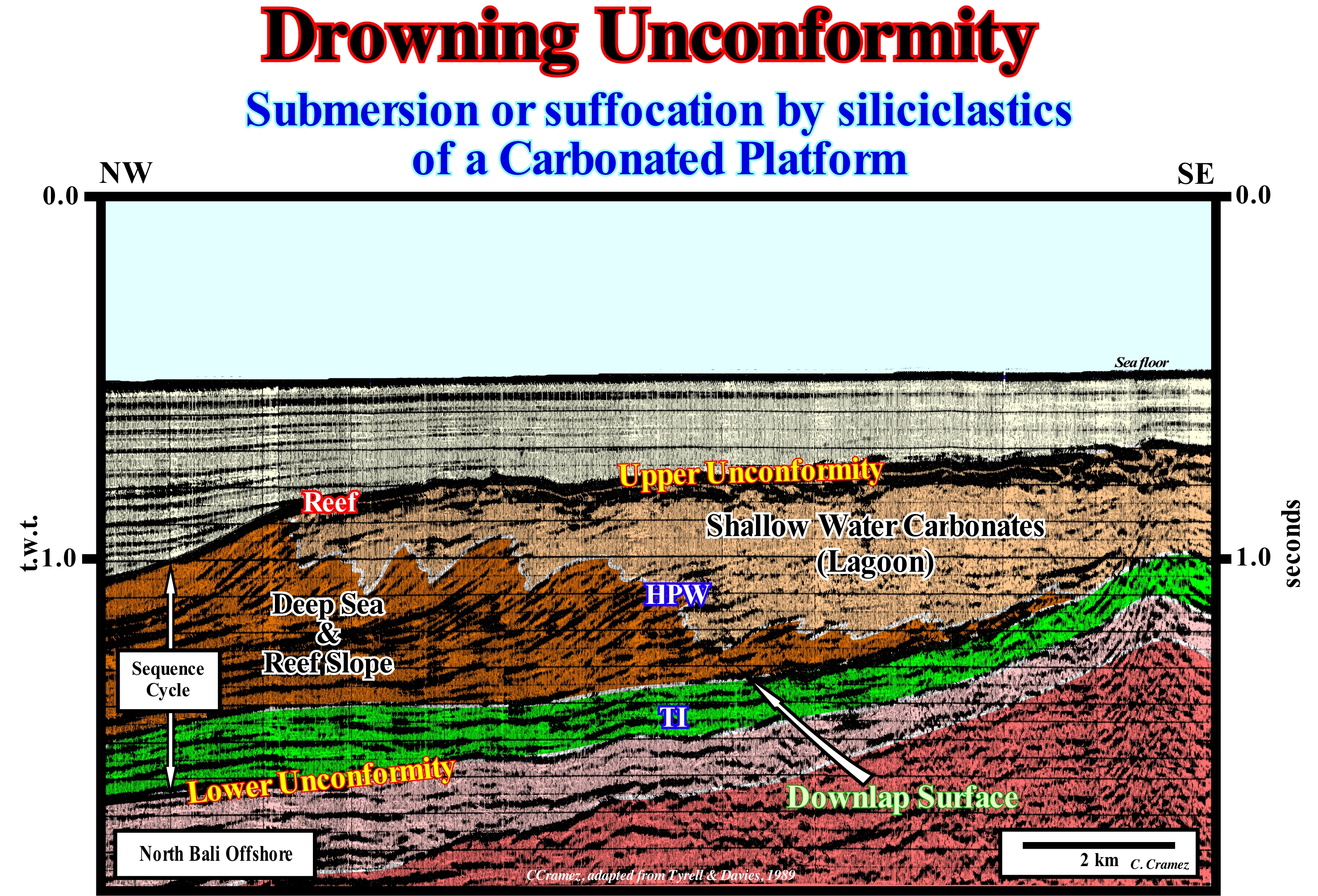
The difference between continental slopes in siliciclastic and carbonated settings has been observed by several geoscientists for many years. However, it was W. Schlager and Camber (1982, 1986) who quantified these differences by studying a large number of carbonate platform slopes and siliciclastic continental slopes. Among other things, they noted that the abrupt drowning of platforms and subsequent burial by siliciclastics produces a discontinuity that resembles, geometrically, the sequence stratigraphy unconformities, i.e., erosional surfaces induced by significant falls in the relative sea level (action combined action of tectonics and absolute or eustatic sea level, which is the global sea level, referenced to the Earth's centre). Even when the slope of a carbonate platform is less inclined than a continental siliciclastic slope, which is relatively rare, the formation of a disconformity is likely when the platform is drowned, just because the sediment dispersion pattern is different in carbonates and in the siliciclastic. In 1986, Schlager and Camber introduced the term "stratigraphic discontinuity by drowning*" for a discontinuity created by drowning of a platform and subsequent overlapping of siliciclastics or other sediments. Schlager proposed to include in this term not only the drowned platforms by submersion under the euphotic zone, but also the platforms "drowned" by siliciclastic or vulcano-clastic sediments, but excluding the discontinuities induced by relative sea level falls that produce the true unconformities in the stratigraphy sequence in the sense of P. Vail et al. (1977) On this seismic line, it is likely that the upper limit of the carbonated sequence-cycle, corresponds to a drowning unconformity, that is to say, that a significant relative sea level fall has placed the sea floor beyond the photic zone, which, of course, caused the end of the carbonate formation and the death of the platform. The discontinuities due to drowning, which in sequential stratigraphy do not correspond to true unconformities, i.e., to stratigraphic cycle boundaries, are, most of the time, associated to an interface between carbonates and siliciclastics, which is typical of the platforms carbonates connected to the continent, i.e., platforms having a significant terrigeneous input after drowning. On isolated platforms, as appears to be the case in the example shown on this seismic line, which are not connected to the mainland, after drowning the terrigeneous influx is weak, which allows the carbonated sedimentation to return after the drowning, if the sea floor reach the photic zone again. Under such conditions, drowning unconformities may also occur between carbonate interfaces. In these cases, they are characterized by hardened surfaces deposited during periods when the sedimentation rate is very low. In sequential stratigraphy, an unconformity by drowning, as defined by W. Schlager, is not considered an unconformity but as a transgressive surface that may correspond to a downlap surface. For some geoscientists, drowning unconformities, considered as flooding surfaces, are limits of stratigraphic cycles in the genetic stratigraphy and not in sequential stratigraphy, in which not all maximum flooding surfaces are unconformities by drowning, but only those induced by the fast and important marine ingressions that put the continental shelf under the photic zone. We recall the sequential stratigraphy is based on the recognition of unconformities and the genetic stratigraphy is based on the interpretation of downlap surfaces. Sequential stratigraphy gives precious indications to petroleum geoscientists, in particular, about the location of the most likely potential reservoir-rocks, since they end up, against unconformities, by onlapping. The genetic stratigraphy, based in the Walther's law, uses the downlap surfaces as limits of the horizontal and vertical sedimentary sequences. Within a sequence-cycle, they are located between the transgressive interval (TI) and the highstand prograding wedge (HPW), and suggest the most likely location of the marine source-rocks.
(*) In fact, they have introduced the term "drowning unconformity," but to avoid confusion we prefer to use the expression "stratigraphic discontinuity by drowning" since the term stratigraphic discontinuity encompasses: (i) Concordant discontinuities ; (ii) Paraconform Discontinuities or Paraconformities ; (iii) Non-conform Discontinuities or Non-Conformities ; (iv) Disconform Discontinuities or Disconformities ; (v) Discordant Discontinuities or Unconformities ; (vi) Reinforced Discordant Discontinuities or Tectonically Enhanced Unconformities ; (vii) Intrusive Discontinuities ; (viii) Mechanical Discontinuities, etc.
Drumlin.................................................................................................................................................................................................................................................Drumlin
Drumlin / Drumlin / Drumlin / 鼓丘 / Друмлин (невысокий продолговатый холм) / Drumlin /
A more or less profiled hill, largely composed of till* with a lesser sharp end oriented in the direction along which the glacier moved. The drumlins can appear in small sets forming drumlin fields.
See: « Depositional Environment »
&
« Glacier »
&
« Till »
A drumlin is a small mound formed by glacial action. The major axis is parallel to the movement of the ice and the most abrupt face of the mound is oriented against the direction of movement (downstream slope). These structures can be more than 50 meters high and more than 1 kilometre long. They are formed by several layers that overlap a nucleus fundamentally formed by a glacial till. There are several theories to explain the drumlin's formation. Certain theories regard drumlins as formed directly by ice, while others consider that drumlins are the result of catastrophic floods of highly pressurized water flowing under ice. Either way, drumlins are interpreted, basically, as a ripple of a current. However, we continue to not understand why certain glaciers have associated drumlin and not others. Drumlins are, often, associated with arched moraines (or Rogen moraines, that is, moraines formed beneath glaciers), which have a morphology similar to the undulations of the sand of the beaches. This type of moraine, which as said before occurs in groups or fields, is oriented transversely to the initial flow of ice, which is not the case for drumlins that run parallel to the flow of ice (in the direction of flow). It can be said that the asymmetrical morphology of the drumlins indicates the direction of movement of the ice. The less inclined side (downstream), as opposed to the upstream slope, is in the direction of movement. The height of a drumlin can vary between 8 and 60 meters and the length exceeds the kilometre. In some cases, the drumlins are arranged in groups more or less parallel to the movement of the glacier as is the case in the scheme illustrated in this figure. Do not forget, that at present it is still difficult to understand whether the sediments have deposited directly in the form of a drumlin or whether this form is the result of later modifications.
(*) Blocks of clay or other sedimentary particles deposited during the melting of glaciers and ice caps.
Dry Delta (Abandoned delta)................................................................................................................................Delta abandonné (Sous-delta)
Delta Abandonado / Delta abandonado / Unterdelta / 被抛弃的三角洲 /Заброшенная (сухая) дельта / Delta abbandonato /
When the upper part of the delta plain is no longer subject to fluvial influence due to the seaward progradation of the delta.
See: « Delta »
&
« Delta Front »
&
« Progradation »
The Ganges-Brahmaputra Delta, also called Ganges, Sunderban or Bengal Delta, is located in Asia, where the Ganges and Brahmaputra rivers discharge into the Bay of Bengal. With an area of about 100,000 km2, it is the largest delta in the world. Approximately two-thirds of the delta belong to Bangladesh. The rest constitutes the state of West Bengal of India. The Ganges delta is the floodplain of three great rivers: (i) Ganges ; (ii) Brahmaputra and (iii) Meghna. Together, these three rivers drain a basin of about 1.72 million km2 on the southern side of the Himalayas. This figure shows a small part of the abandoned delta, that is to say, the upper part of the deltaic plain which, due the progradation of the delta progradation, is no more disturbed by the influence of fluvial and tidal deltas*. During the Pleistocene, before the junction of the rivers, the deltaic activity of the Ganges and Brahmaputra rivers shifted several times. Currently, the active sedimentation area located in the eastern sector. The northern part represents the abandoned delta plain, where traces of abandoned channels dominate the morphology of the region. The shape and abundance of these channels vestiges, which were, probably, the bed of the Ganges River and many of its distributaries**, suggests the existence of an old meander belt, that is to say, an area developed over a valley filled with a floodplain sediments, on which meanders serpentine due a low slope thalweg of the water-courses. During flooding periods, the rivers of the meander belt, which has, recently, been much modified by human activity, overflow the original margins flooding the adjacent areas. The size of the traces of fossil channels is similar to that of the channels currently active along the Ganges and their distributaries. Many of these ancient river channels are now dominated by tidal water. Hooghly and Pusar rivers are perfect examples of ancient beds of the Ganges River, which today are dominated by the tides. Oxbow lakes and meander relics are very common in the abandoned delta area. The inner part of the tidal plain was protected by dikes and the old salted lands were converted into agricultural land. This region, which was originally an immense mangrove forest ("Sunderbans"), still retains a little of the original delta morphology, although it is already well concealed by the tidal drainage network (set of channels that are connected to each other and drain the water from tidal currents, which may be artificial, man-made, or natural). The large tidal channels, well visible south of the abandoned delta area, form bell-shaped estuaries that are deep enough to be used as transport roots. Inland, the estuary channels are very sinuous. They are, relatively, stable, since lateral migrations are rare. The comparison of old aerial photographs with modern satellite imagery suggests stable channel paths for at least the last 20 years. In the deep offshore, probably, in association with the floods of the Ganges/Brahmaputra, turbiditic slope fans were deposited. Some "gull wing" structures (opposite turbiditic natural levees and the filling of the depression between them) exceed more than 500 m of thickness. The overloading of sediments deposited in direct or indirect association with the Ganges-Brahmaputra river produces a significant subsidence of the seafloor, which, naturally, induces a significant relative sea level rise. Such a marine ingression, has nothing to do with what is, regularly, advertised by the media and, particularly, by some naive ecologists (verificationist). This rise of the relative sea level, that is to say, the rise of the sea level referenced to an Earth's surface, whether the sea floor or the top of the continental crust (bottom of the sediments) is not a consequence of anthropogenic global warming and, particularly, due to an increasing of CO2 in the atmosphere. It is just the consequence of the subsidence (sinking) of the sea floor due to the weight of the sediments. Values of 10/20 m of relative sea level rise per year are frequent not only along the coast but also along the Meghna River. There are other types of delta such as: (i) Fan delta ; (ii) Arctic delta ; (iii) Arcuate delt a; (iv) Atrophied delta ; (v) Complex or Polymorphic delta ; (vi) Cuspate or Blunt delta ; (vii) Fingers or Digitated delta ; (viii) Flow delta ; (ix) Closed delta ; (x) Gilbert-type delta ; (xi) Lava delta ; (xi) Lobated delta ; (xiii) Tidal delta ; (xiv) Submarine delta ; (x) Storm delta ; (xvi) Wave delta ; (xvii) Ebbing delta, etc.
(*) Submarine deltas formed in symmetrical position, at the openings of the lagoon or in the straits, due to the circulation of the tidal currents.
(**) It is important to differentiate distributary and tributary. A distributary is a water-course that branches off and flows away from the main channel (river bifurcation). A tributary is a water-course that flows into a larger one. A distributary flows directly into the sea, which is note the case of a tributary, which flows into larger stream or a lake.
Dry Valley.............................................................................................................................................................................................................................Vallée sèche
Vale seco / Valle seco / Trockenes Tal / 干热河谷 / Сухая долина / Valle secco /
Valley excavated in a karst by surface water-course, which, normally, no longer has any subaerial flow.
See: « Karst »
&
« Sinkhole »
&
« Blind Valley »
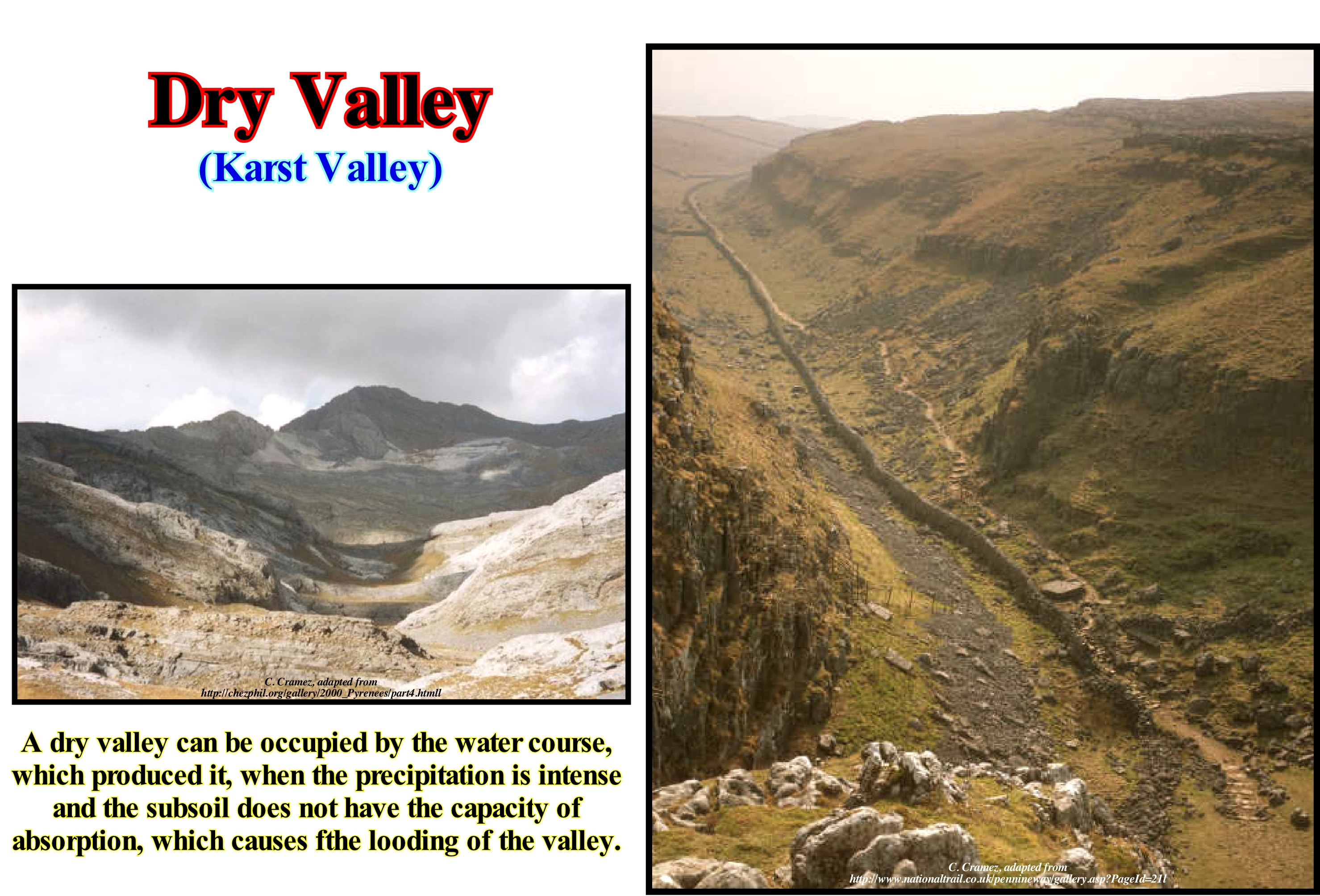
As stated above, a dry valley is a valley where a water course has already flowed, but which is currently either permanently or seasonally without water due to a diversion of the water line through the karstic subsoil. It can still be occupied by the water-course when the precipitation is intense and the sub-soil does not have the capacity of absorption, occurring a flood of the dry valley. Frequently, dry valleys contain large pebbles. They only have circulation during floods when there is too much energy for the sand and silt to settle. There are two theories to explain the formation of dry valleys: (i) The former considers the water-table to be much higher ; (ii) The second considers that during the last glaciations the permeable limestone (chalk) became impermeable due to the permafrost, thus allowing the rivers to flow without not carving the rocky substrate. At present, these valleys do not have rivers because the water infiltrates through the limestone, which has become porous again, to seep into the subterranean cavern. The vast majority of geoscientists consider other types of dry valleys with different origins. One can speak of dry valleys by hydrographic capture, when the valley was enclosed by a stream that was later diverted or captured by another stream, like dry valley north of Calamboloca (Kwanza basin, Angola) due to the deviation to the west of the river Kwanza. In the same way one can speak of dry valleys due to aridity, when the valley has dried up due to extreme temperatures that transform the region, practically, into a desert, as is the case, for example of the famous Death Valley of Sierra Nevada (California) in U.S. It is interesting to note that many people consider a "dry valley" in a figurative sense, which has nothing to do with a climatological or geomorphological drought. For example, the "Valais dry valley" in Switzerland, is a region without alcohol. This is also the case of the "dry valley" of the Canton of Vaud (Switzerland) which groups several communes of the Morges region due to the absence of taverns and cafe-restaurants in most villages.
Dune.........................................................................................................................................................................................................................................................................Dune
Duna / Duna / Düne / 沙丘 / Дюна / Duna /
Sand pile built by wind processes.
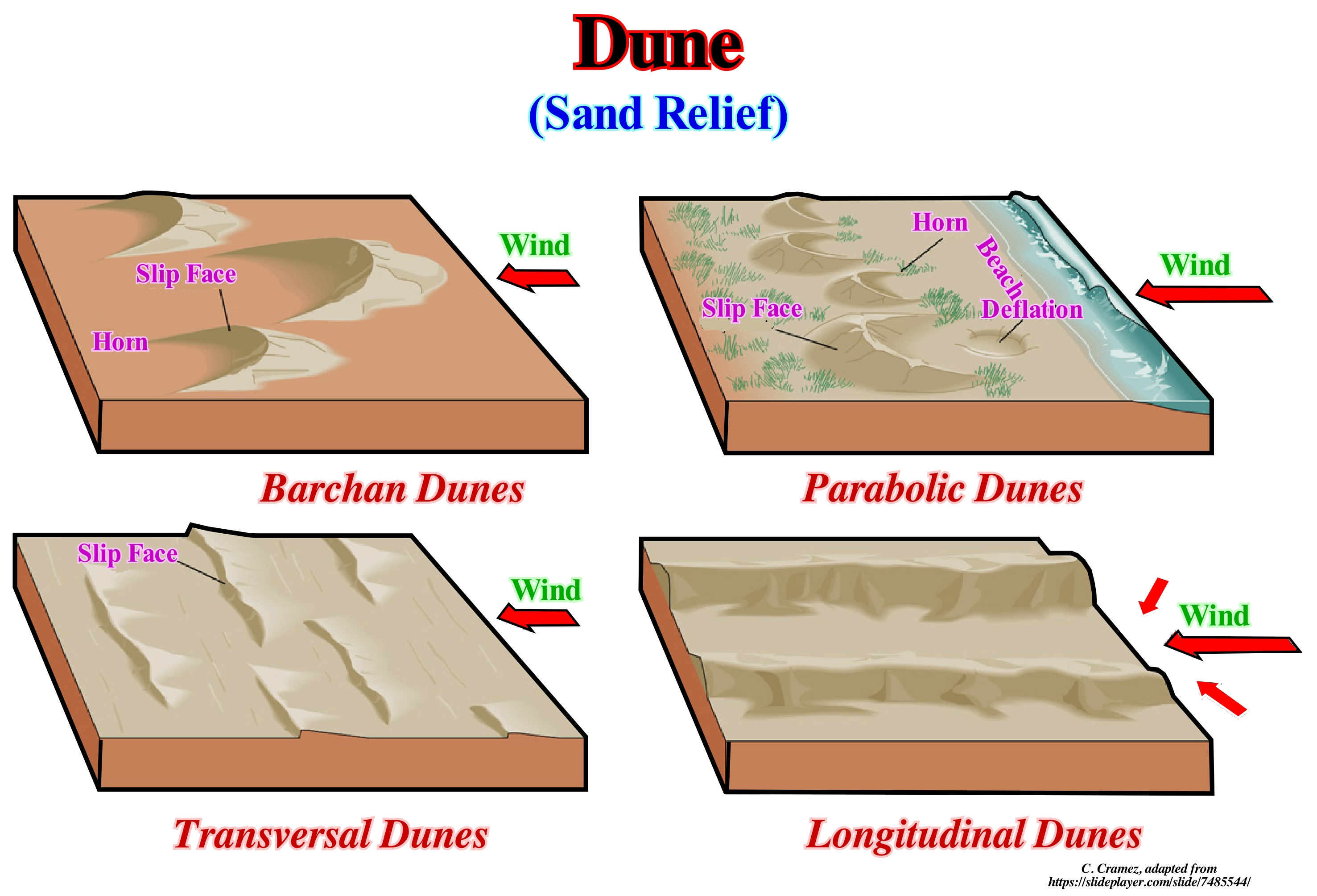
The origin of the sand dunes is very complex. There are three essential prerequisites: (1) An abundant supply of loose sand in a region, more or less devoid of vegetation ; (2) Sufficient wind energy to move the grains of sand, and (3) A topography in which the sand particles can lose their energy and settle down. A number of objects, such as shrubs, rocks, or fence posts, may oppose the force of the wind and cause stacking of the sand on small mounds and finally on large dunes. Certain geoscientists mention the presence of ant hills that form the nucleus on which the sand dunes develop. The direction and speed of the wind, in addition to the local sand carrier, produce a great variety of shapes and sizes of the dunes. The wind individually moves the grains along the sloping surface from windward to crest, which slide on the leeward side (slip face), accumulating at the base invading slowly new areas. Some dunes with crests of only 30 meters high can advance 50 meters per year, which is a great threat to the dwellings, farms and roads of the surroundings. If the wind direction is sufficiently uniform over the years, the dunes gradually change in the prevailing wind direction. The vegetation can stabilize a dune, preventing its movement with the prevailing wind. Along the coast of certain areas of the United States of North America, entire forests may grow in dune areas. At times, large storms or other disturbances can destroy the canopy forest allowing the nearby sand dunes to enter the disturbed area. The structure and mineral composition of sand grains that form a dune depends on the geology of mountains that have been eroded by wind and water. Although most of the dunes are made up of quartz grains and feldspar, white sands White Sands in New Mexico are made of gypsum grains. The famous black sand dunes of the beaches of the tropical islands of the South Pacific are made of small volcanic particles. The white sand dunes of the tropical beaches (corals and atolls) are composed of a very bright variety of microscopic animals, algae, coral fragments, foraminifera, etc. (http://waynesword.palomar.edu/ww0704.htm #Introduction).
Duripan..................................................................................................................................................................................................................................................Duripan
Duripan / Duripan / Duripan (Boden-Horizont) / Duripan (土层) / Дюрипэн (плотный горизонт почвы) / Duripan (Orizzonte del suolo) /
Horizon of a soil hardened by illuvial silica cementation.
See: « Soil »
&
« Illuvial »
&
« Fragipan »
The duripan is an underground horizon cemented with silica in such a way that the dried fragments do not disintegrate during prolonged immersion in water or hydrochloric acid. Th phase* of duripan characterises soils that have a duripan whose top is less than 100 cm deep. Duripans differ in their degree of cementation due to silica. In addition, they usually contain accessory cements, especially iron oxides and calcium carbonate. Riparians have varied aspects, but they all have a very firm or extremely firm consistency when moist and are always brittle. The riparian is similar to a fragipan, i.e., a petrochemical horizon, and a petrogenesis horizon, which are firmly cemented. In soil descriptions the riparians are often indicated by Bqm symbol. The closest equivalent in Canada's land classification system is the so-called Duric horizon, although this does not mean exactly the same thing as a duripan in the United States. Duripans form almost exclusively in arid regions or Mediterranean climates, and can be as hard as cement, making them very difficult if not impossible to plow. Soils containing duripans are, generally, used for grazing or habitat of wild animals and are rarely cultivated. According to the North American soil taxonomy proposed in 2006, the characteristics required for a soil to be considered as a duripan are: (i) To be cemented or hardened by more than 50 percent of the horizon volume ; (ii) Show evidence of accumulation of opal and other forms of silica, such as coatings, lenses, partially filled interstices ; (iii) Less than fifty percent of the (dry) fragments are effervescent hydrochloric acid (HCl), but more than 50 percent are effervescent KOH (potassium hydroxide or potassium hydroxide) or concentrated NaOH (sodium hydroxide or caustic soda) ; (iv) Due to their lateral continuity, the roots can penetrate the duripan only along horizontally spaced vertical fractures of 10 cm or more. Duripans occur primarily in arid or semi-arid climates, where the soil is, generally, dry or seasonally dry. Soils with duripans are often geographically associated with areas of strong volcanic activity and show evidence of sodium carbonate or volcanic glass deposition. Volcanic glass changes rapidly, providing a broad supply of soluble silica, to cement the underlying soil. Other frequent sources of silica (cementing agent) are the minerals is ferromagnesian and feldspars.
(*) Phases are limiting characters linked to the properties of the soil or subsoil surface and are not necessarily related to the pedogenesis and cross the boundaries of the different soil units. (https://books.google.ch/books?isbn=9252026223).
Dychothermy....................................................................................................................................................................................................................Dichothérmie
Dicotérmia / Dicotermia / Dichothermy / Dichothermy / Дихотермия / Dichothermy /
Inversion in thermal stratification of marine waters.
See: « Isotherm »
&
« Stratification (water) »
&
« Blue Ocean »
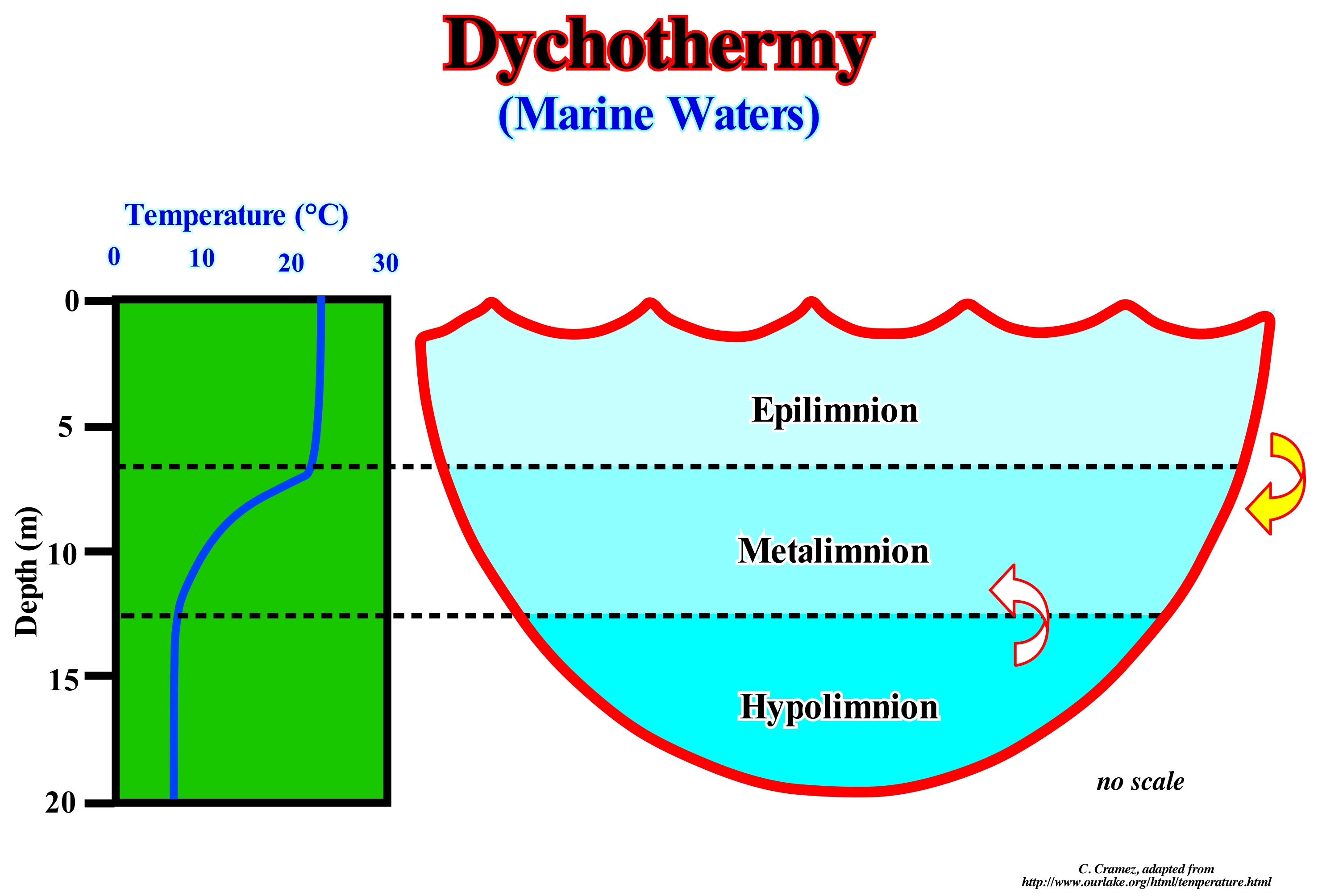
Thermal stratification refers to stratification occurring, mainly, in hot months, during which a layer of warmer and less dense water (epilimnion) overlaps a denser and colder layer (hypolimnion). Thermal stratification is a common phenomenon in the deep and temperate lakes of the Northern Hemisphere, such as the Lake of Audition. Between these two layers there is a third layer (metalimnion), where there are large vertical differences in temperature (temperature gradients) and therefore where density variations prevail. The vertical temperature profile shown above illustrates this layered arrangement for a summer hypothetical profile. The configuration of this graph may seem a bit atypical when compared to the formats used in other scientific disciplines: on the surface the upper part of the Y axis (depth axis) is placed, with increasing depths downwards. This convention is often used by geoscientists studying lakes (limnologists) in all vertical profiles, since their configuration is consistent with the nature of the vertical measurements of the profile. Thermal stratification is considered as an important regulator of the global metabolism of lakes. Epilimnion is relatively well mixed since it is subject to wind-induced mixing. In contrast, the blend is much more limited in the hypolimnion because the deeper layers of the lakes are isolated from the energy inputs transmitted from the surface of the lake. The exchanges of substances dissolved between epilimnion and hypolimnion (through metalimnion) are quite limited due to the low level of turbulence and mixing. Generally, the higher the temperature/density gradient of the metal, the less there will be through this layer. This blend (limited) has implications for the recycling of essential components (nutrients and dissolved oxygen). The thermal stratification characteristics of a system such as the recycling time and the beginning of the stratification, thickness and temperature of these ranges are manifestations of a certain number of specific characteristics of the system and the influence of the environmental conditions conditions ("forcing" ). These characteristics are regulated by the basin's morphology (size, shape, depth), geological context, meteorological conditions, hydrology, and extent of light penetration.
(*) The term climate forcing is used when there are variations in the nature of the rocks of a sedimentary series and that they are due to the climatic changes.
Dynamic Allotropy....................................................................................................................................................................Allotropie dynamique
Alotropia dinâmica / Alotropia dinámica / dynamische Allotropie / 动态同素异形体 / Динамическая аллотропия / Allotropia dinamica /
In this type of allotropy, the two alotropic forms exist in equilibrium. The ratio of the two allotropes which are in equilibrium with one another varies with temperature and sometimes with pressure. The two liquid forms of sulfur exhibit this type of allotropy, and the change from one form to the next is accompanied by a change in color and its viscosity (resistance to flow).
See: « Allotropy »

