
B-Type Subduction (Benioff).........................................................................................................Subduction de type B (Benioff)
Subducção de Tipo-B / Subducción tipo B (Benioff) / B-Typ Subduktion (Benioff) / B型俯冲(贝尼奥夫)/ Субдукция типа Б (Бениофф) / Subduzione tipo-B (Benioff) /
When an oceanic lithospheric plate dives under the continental crust or under a volcanic arc. A type-B subduction can occur : (i) In an oceanic domain (ocean/ocean), such as in the Mariana Islands or Tonga ; (ii) At the boundary between an ocean and a continent (ocean/continent), as in Western South America and (iii) At the edge of a continent, but in a median position, i.e., when a, more or less, developed oceanic basin forms between the subduction zone and the continent (ocean/interior basin / continent), as in Aleutian Islands.
See: « Continental collision »
&
« Oceanic Expansion »
&
« Deep Ocean Floor »
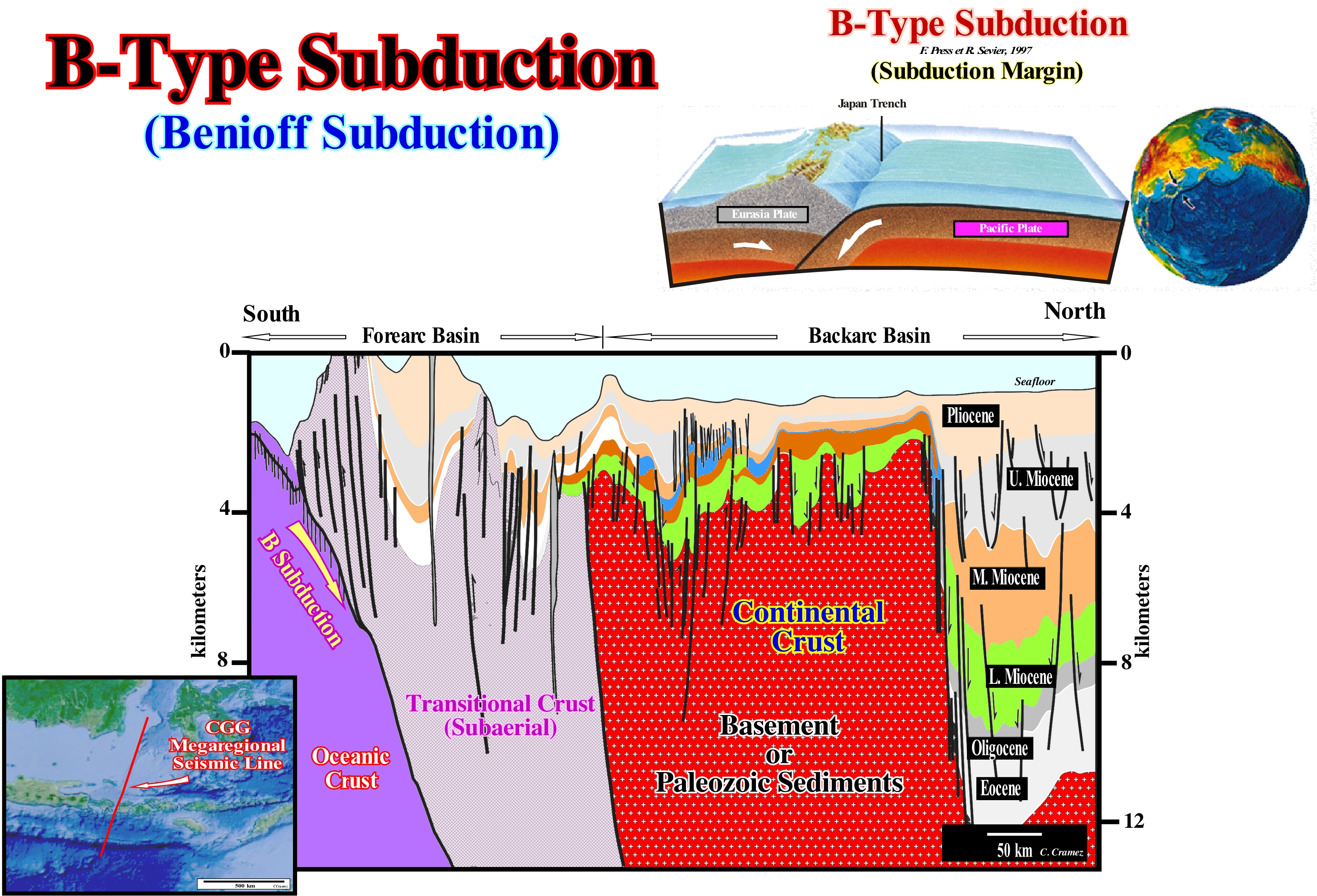
As illustrated on this tentative geologically interpretation of an Indonesia offshore regional seismic line, whose location is shown in the map (between southern Borneo and southern Java), a B-type subduction zone (Benioff or Benioff-Wadati) is characterized by the plunge of a lithospheric oceanic plate into the asthenosphere (a ductile part of the terrestrial upper mantle extending from the lithosphere to the lower mantle for more than 700 kilometers and consisting of ductile silicate materials in the solid and partial state or fully semi-funded function of the depth and/or proximity of huge mass of magma). A B-type subduction zone or Benioff (named after the American geoscientist Hugo Benioff) contrasts with an A-type subduction zone (diving of a continental lithospheric plate under another, in a collision zone, creating a geological shortening over several hundred kilometers). It can recycle thousands of miles of oceanic crust and upper mantle. As many geoscientists say, the subduction zones, and in particular the Benioff subduction zones, are areas where the oceanic spreading (sea-floor spreading) initiated in the mid-oceanic ridges is compensated, i.e., areas where the lithospheric plates and, in particular, the oceanic lithospheric plates disappear. As the basaltic layer and the sedimentary cover are buried they increase their temperature. Since the melting temperature of the basalt/water/sediment mixture is reached all the material melts creating a volcanic magma. As this magma is less dense than the surrounding mantle, it rises to surface forming volcanoes on the overriding plate. This explains one of the main characteristics of the B-type subduction zones, i.e., the formation of volcanoes on the overriding plate at a certain distance from the oceanic trench. This distance is a function of the subduction angle, which is the angle between the plunging plate and the Earth's surface. In South America, it is easy to see the position of the volcanic arc of the overriding plate is not the same in the northern and southern part, which geoscientists explain by the different subduction angles of the oceanic plate. The subduction angle is a function of several parameters: (i) Thermal state, i.e., plus the subducting plate is younger, plus it is lighter and smaller is the subduction angle, once the resistance to the incoming of the plate into the asthenosphere is very large ; (ii) Rheology of the surrounding regions (if the surrounding oceanic lithosphere has a small density, it can, at the moment of the entrance of the subduction plate, induce extensional deformations reducing the angle of subduction ; (iii) Relative velocity of the plates (between 1 and 10 cm per year), if the relative velocity between the plates is small, the vertical component of the subduction has all the time to become preponderant increasing the subduction angle ; (iv) Velocity of the overriding plate, i.e., when the overriding plate moves towards the ocean trench, the angle of subduction is smaller than when it moves in another direction. The B-type subduction zones are important for several reasons (https://en.wikipedia.org/wiki/Subduction): (i) Subduction Zone Physics: the plunging of the oceanic lithosphere (sediments, crust, mantle), by density contrast between the old cold lithosphere and the warm asthenospheric mantle, is the most important force (but not the only) necessary to drive the plate motion and is the dominant mode of convection of the mantle ; (ii) Subduction Zone Chemistry: subducting sediments and the crust dehydrate and release water-rich fluids (aqueous) in the overlying mantle, causing fusion and fractionation between the shallow and deep mantle reservoirs, producing volcanic arcs and continental crust ; (iii) Subduction zones entrain oceanic sediments that have entered in subduction, oceanic crust and mantle lithosphere interacting with the warm asthenospheric mantle of the overriding plate producing a series of mixture calcoalkalines, ore deposits and continental crust. The subduction zones were considered as possible nuclear waste disposal sites in which the action of the subduction itself would transport the material into the planetary mantle far from any possible influence on mankind or the surface environment. However, this method of disposal is, currently, prohibited by international agreement. In addition, plate subduction zones are associated with major earthquakes, rendering unpredictable the effects on the use of any specific site for disposal and possibly adverse to the safety of long term disposal.
Bacckarc Basin...........................................................................................................................................................................Bassin d'arrière-arc
Bacia interna ao arco / Cuenca interna de Retro-arco / Back-Arch Becken / 弧后盆地 / Задуговая котловина / Bacino di retroarco /
Episutural sedimentary basin developed within a megasuture in association with an insular arch and a Benioff subduction zone (B-type subduction). Most of these basins result from the tensile stresses (traction or compression) caused by the ocean trenches and the collapse of the continental ridge.
See: « Sedimentary Basin »
Backshore (Inshore).............................................................................................................................................................................................Arrère-plage
Antepraia / Anteplaya / Hinterstrand /后滨 / Отбрежье (верхняя береговая терраса) / Indietro spiaggia /
Coastal zone, generally, dry, relatively, narrow between the highest line of the equinox tides (lower boundary) and the upper part of the coastal process zone (base of the littoral cliff). The backshore (inshore) is covered by water only during storms and high-tides. The geometry of the backshore is, generally, subhorizontal or slightly inclined continentward. The crest of the berm further seaward separates the backshore from the shoreface.
See: « Berm-Ridge, Storm Beach »
&
« Beach »
&
« Cliff »
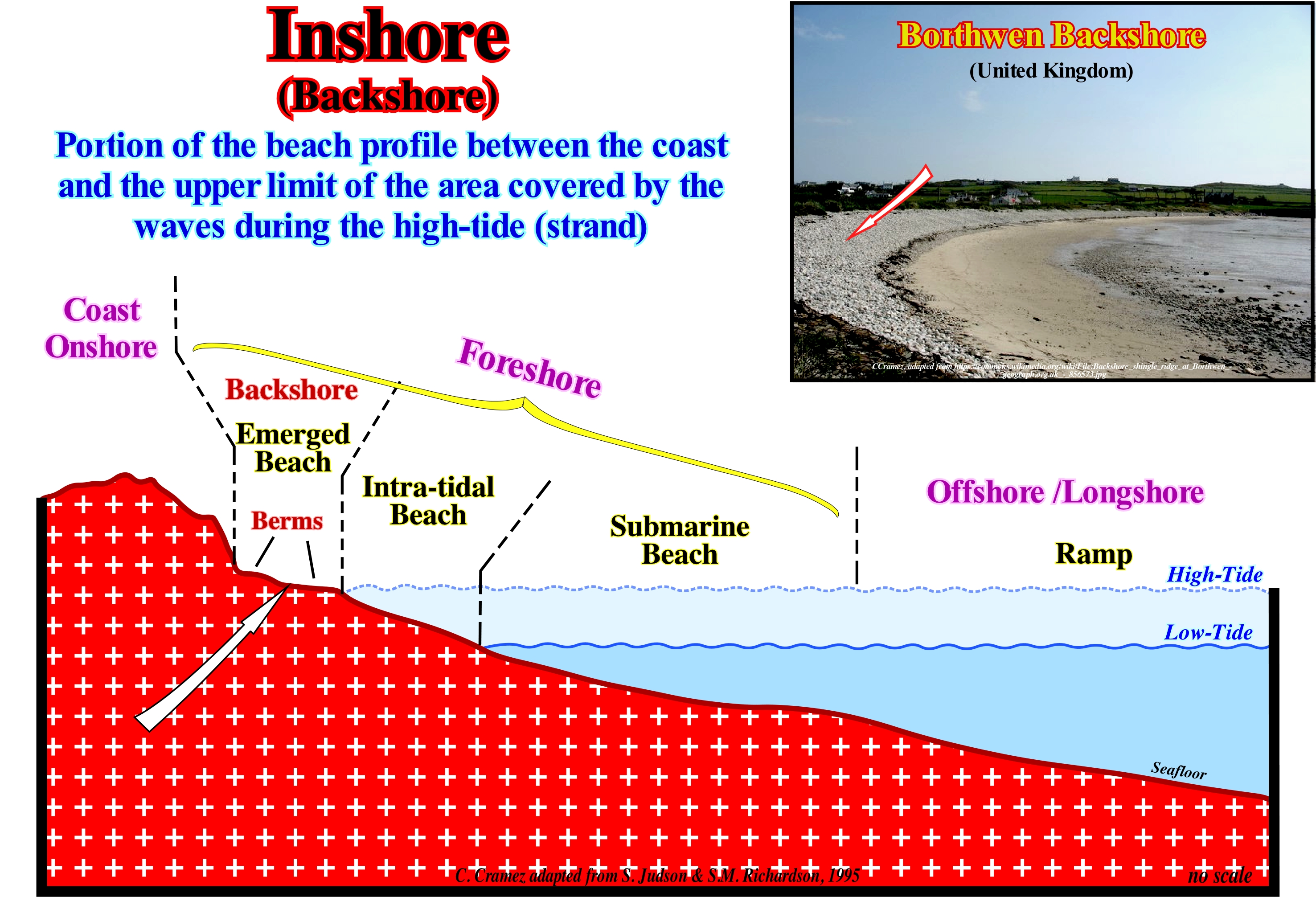
Many coastal zones, especially, those that have a siliciclastic lithology, exhibit a morphology similar to that illustrated in the geological section of this figure. The area with a, more or less, concave geometry, between the high-tide line and up to a depth of 5-20 m, is the foreshore, which encompasses the intra-tidal beach and the submarine beach. Seaward from the foreshore, the sea-floor forms a ramp, which slopes, gently, towards the continental edge, which in this case corresponds to the platform's edge. In the foreshore, there are bars and lows induced by the surf of the waves. The inter-tidal beach lies between the high-tide and low-tide lines, while the backshore extends between the high-tide line and the beginning of the dunes. In the backshore, there are one or several berms that look like small terraces with small slopes on the sea side. When a relative sea level rise (combination of absolute or eustatic sea level* and tectonics), the morphology of the beach determines, largely, the value of the continental encroachment, i.e., the value of the horizontal component of the coastal aggradation. If the beach morphology is, relatively, flat, a relative sea level rise of about 10 meters will displaces the depositional coastal break of the depositional surface (roughly the shoreline) several kilometers continentward. On the contrary, if the beach morphology is, relatively, sloping seaward, the same relative sea level rise will displace the depositional coastal break of the depositional surface (and associated coastal deposits) landward just tens or hundreds of meters. As the relative sea level falls, the seaward and downward displacements of the depositional coastal break of the depositional surface is, also, a function of the morphology of the foreshore and the ramp. In sequential stratigraphy, it is, always, important to calculate the value of the vertical and horizontal component of the coastal aggradation in order to determine the morphology of the coast and particularly the morphology of the beaches. Backshore, foreshore and longshore (offshore) is one of many divisions of coastal morphology found in scientific literature. As each country, not to say each geoscientist, tends to use its own divisions and its own terminology, it is important not to forget the bibliographical reference of the terms used.
(*) Global sea level referenced to the Earth's centre. It is the result of the combined action of: (i) Tectono-eustasy (controlled by volume variation of ocean basins) ; (ii) Glacio-eustasy (controlled by the variation of ocean water volume) ; (iii) Geoidal-eustasy (controlled by the distribution of ocean water caused by variations in the terrestrial gravity field) and (iv) Thermal expansion of the oceans or steric sea level rise.
Backstepping (Retrogradation)................................................................................................................................................Rétrogradation
Retrogradação / Retrogradación / Degradierung, Stichgenaues / 退积 / Явление обратной конденсации (обратный процесс) / Retrocessione /
Continentward displacement of the depositional coastal break (roughly the shoreline) within the transgressive interval (TI) of a sequence-cycle, during an accelerated relative sea level rises (marine ingression). A retrogradation is, usually, associated with a succession of increasingly smaller progradational sedimentary episodes. It occurs every time a progradational unit does not develop beyond the preceding progradational unit. A retrogradation indicates a series of increasingly important marine ingressions (relative sea level rises) and the associated increasingly smaller sedimentary regressions, with no relative sea level falls between them (eustatic paracycles).
See: « Transgressive Interval »
&
« Systems Tract (sedimentary) »
&
« Relative Sea Level Rise »
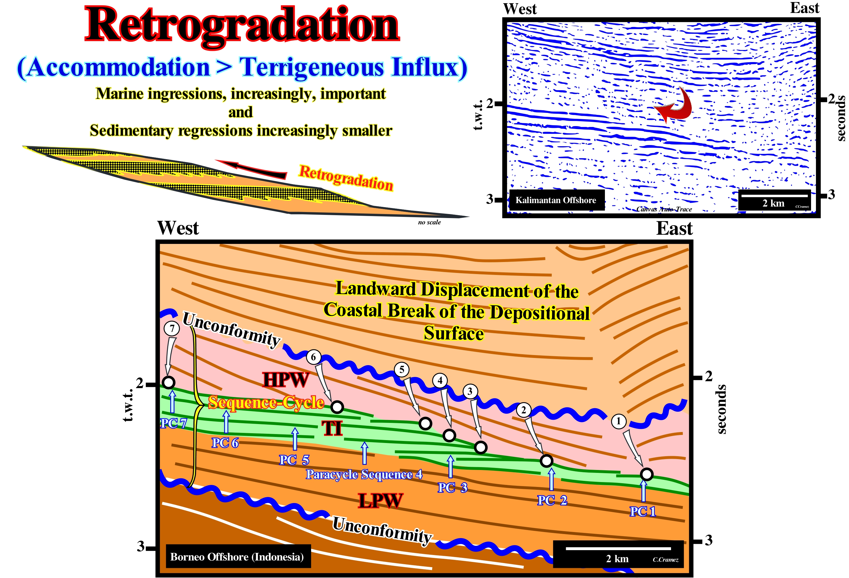
Within a sequence-cycle, the relative sea level rise (local sea level referenced to any fixed point of the Earth's surface, which can be the base of the sediment, i.e., top of the continental crust or the sea-floor and that is the result of the combined action of tectonics and the absolute or eustatic sea level*) that initiates the highstand systems tracts group (GHST), induces a continentward displacement of the depositional coastal break (more or less, the shoreline, particularly on the seismic lines,i.e., taking into account that the seismic resolution is in 2D seismic lines around 30/40 meters). Such a displacement of the shoreline creates or increases the shelf and the water-depth, as the rise in relative sea level is in acceleration (increasingly important marine ingressions). However, a relative sea level rise is not in continuity. Many geoscientists speak of composite marine ingression and single marine ingressions. Single marine ingressions are increments of a composite marine ingression. A relative sea level rise is, in the majority of the cases, done in steps, as, for instance: (i) Rise in relative sea level of 3 m (single marine ingression) ; (ii) Stability period of the relative sea level ; (iii) Relative sea level rise of 5 m (single marine ingression) ; (iv) Stability period of the relative sea level ; (v) Relative sea level rise of 7 m (simple marine ingression) ; (vi) Stability period of the relative sea level ; (vii) Relative sea level fall of 10 m (marine regression). In this case, globally, the relative sea level rose 15 meters (composite marine ingression) in acceleration. The single marine ingressions are increasingly greater. The terms single and composite marine ingression should be used whenever clarification is required. The first relative sea level rise, i.e., the first single marine ingression (first eustatic paracycle), is followed by a stability period of the relative sea level, during which the shoreline and the associated coastal deposits move seaward, as the sediments prograde towards the continental edge, which is now, also, the basin edge. However, the shoreline does not reach the position it had before (retrogradation). Thus the first sequence-paracycle is deposited. The second relative rise in sea level (second single marine ingression), that is, the second eustatic cycle, which is more important than the first, as the relative sea level rises in acceleration, again, displaces the shoreline landward increasing the extension of the shelf and the water-depth. A new period of relative stability of the sea-level allows, again, the displacement of the shoreline seaward and the deposition of progradational sediments (second sequence-paracycle), but without the shoreline reach the position it had in the end of the preceding sequence-paracycle, which, globally, corresponds to a retrogradation as illustrated on this tentative geological interpretation of a Canvas auto-trace of a detail of an Indonesia offshore seismic line. This mechanism (relative sea level rise - stability of the relative sea level - relative sea level rise) continues until the first rise, in deceleration, in the relative sea level (smaller than the previous one), which initiates the deposit of the highstand prograding wedge (LPW). What certain geoscientists, incorrectly (in our opinion), call transgression or the continentward displacement of the shoreline and associated coastal deposits, is nothing more than a succession of ever larger single marine ingressions and increasingly smaller sedimentary regressions. It is this set of marine ingressions and sedimentary regressions, which, globally, has a retrogradational geometry, that Cesare Emiliani (1992) called "Transgressions" (not transgression). The internal configuration of sequence-paracycles is progradational. Between consecutive eustatic paracycles there is no relative sea level fall. Sediments are deposited during the stability period of relative sea level occurring between two eustatic paracycles. In other words, between two eustatic paracycles there is any erosional surface (unconformity), but, just, a ravinment surface. On this tentative geological interpretation of a Canvas auto-trace of a detail of a Borneo offshore seismic line, within the considered sequence-cycle, limited by two unconformities (in blue), it is easy to recognize the sequence-paracycles, which here correspond to sedimentary systems tracts forming the lower highstand systems tracts sub-group called Transgressive Interval (TI). It is possible that in this particular case, each sequence-paracycle corresponds to a unique sedimentary systems tract. The retrogradation of the depositional coastal break of the depositional surface (chronostratigraphic line), which corresponds, more or less, to the retrogradation of the coastline, is obvious.
(*) Global sea level referenced to the Earth's centre. It is the result of the combined action of: (i) Tectono-eustasy (controlled by volume variation of ocean basins) ; (ii) Glacio-eustasy (controlled by the variation of ocean water volume) ; (iii) Geoidal-eustasy (controlled by the distribution of ocean water caused by variations in the terrestrial gravity field) and (iv) Thermal expansion of the oceans or steric sea level rise.
Backstepping (Geometry)...............................................................................................................................Géometrie Rétrogradante
Geometria retrogradante / Geometría retrogradante / Backstepping / 几何rétrogradante, 反推 / Ретроградационная геометрия / Geometria rétrogradante, Backstepping /
Retrogradational (continentward geometry) of the long term envelope of the depositional coastal break (± the shoreline) during a set of gthe marine ingressions (progressively importnt) and sdedimentary regressions (progressively smaller), which the geoscientists call, collectively, sedimentar transgressions. A backstepping implies a progressive increase in extension of the shelf (continental platform). This type of geometry characterizes transgressive deposits, since, globally, the depositional coastal break of the successive chronostratigraphic lines recedes* and rises continentward. Sedimentation (sedimentary regressions) occurs during the stability periods of the relative sea level between the eustatic paracycles. The retrogradational geometry is, partially, due to the fact that the extension of the shelf increases at each eustatic paracycle (assuming a sedimentary supply, more or less, constant).
See: « Progradation »
&
« Marine Regression »
&
« Downlap »
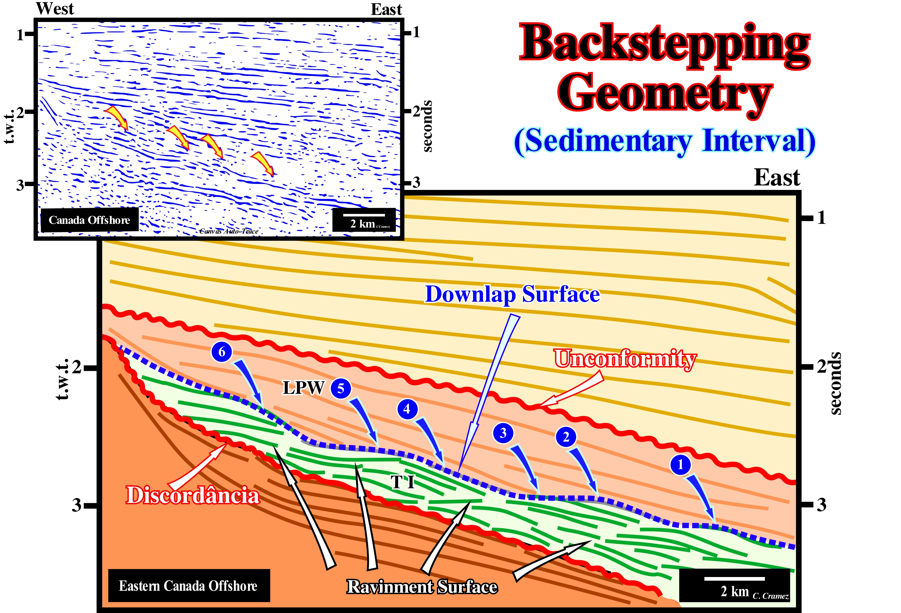
On this tentative geological interpretation of a Canvas auto-trace of a detail of a Labrador (Canada) offshore seismic line, the backstepping geometry of the transgressive interval (TI) of a sequence-cycle, induced by a 3rd order eustatic cycle, whose time-duration varies between 0.5 and 3-5 My, is well visible. The reflectors (coloured green) of the transgressive interval (TI), as well as, its upper limit (in blue), which corresponds to downlap surface, globally, has a retrogradational geometry. The term globally wants to say here that although between two successive ravinment surfaces (relative sea level rise or marine ingression), the reflectors of the sequence-paracycles, which underline sedimentary regressions, individually have a progradational geometry. The set of all sequence-paracycles has a geometry retrogradational, once, globally, the shoreline moves landward. As all clastic sediments come from the mainland (except those remobilized by the coastal marine currents), this geometry is, perfectly, understandable and logical. A ravinment surface emphasizes a relative sea level rise induced by an eustatic paracycle. The sediments deposited between two consecutive ravinment surfaces underline a sequence-paracycle, which is deposited during the stability period of the relative sea level separating each rise of the relative sea level (there are any relative sea level fall between them). During the deposition of a transgressive interval of a sequence-cycle (sedimentary transgressions), everything seems to pass as follows: (i) The first relative sea level rise (marine ingression) creates a flooding and a ravinment surface (under highstand geological conditions) ; (ii) The marine ingression moves landward the shoreline (more or less, the depositional coastal break of the depositional surface), with the formation of a small shelf ; (iii) During the stability period of relative sea level following the marine ingression (there is no relative sea level fall), the sedimentary particles, gradually, deposit and prograde seaward, reducing the extent of the shelf (sedimentary regression) displacing seaward the shoreline, but without that it reaches the position that it had before the marine ingression ; (iv) A new rise (in acceleration) of the relative sea level (more important than the previous one), which again moves continentward the shoreline with the formation of a new ravinment surface and increase the extension of the platform ; (v) During the next stability period of relative sea level, sediments are deposited by progradations and the shoreline moves seaward, but without reaching its extreme position which it reached during the preceding sequence-paracycle ; (vi) New marine ingression in acceleration, which once again moves the shoreline continentward with formation of a new ravinment surface ; (vii) New stability period of the relative sea level and new displacement of the shoreline seaward, as the sedimentary particle deposit by progradations, but without the shoreline reaching the position it had at the end of the preceding sequence-paracycle, and so on, until the first relative sea level rise is deceleration, i.e., smaller than the previous one, which implies the beginning of the deposition of the highstand prograding wedge (HPW), which will, gradually, fossilize the transgressive interval (TI). In conclusion, it is the succession of increasingly important marine ingressions (relative sea level rises in acceleration) and the increasingly smaller sedimentary regressions (sequence-paracycles) that form, collectively, the transgressive interval (TI) of a sequence-cycle (transgressions), whose geometry is backstepping or retrogradational since the shoreline moves, globally, continentward. Thus, to avoid confusion, it is always preferable define certain terms used in sequential stratigraphy such as: "Marine Ingression" (relative or absolute sea level rise) ; "Sedimentary Regression" (sequence-paracycle, usually formed by a single sedimentary systems tract, during which the shoreline moves seaward, normally without aggradation, formed by one or more sedimentary systems tracts) ; "Sedimentary Regressions" (set of increasingly larger sedimentary regressions, which, collectively, have a prgradational geometry) ; "Sedimentary Transgressions" (a set of increasingly smaller sedimentary regressions induced by increasingly larger marine ingressions that collectively have a retrogradational (backstepping) geometry ; "Relative Sea Level" (local sea level referenced to base of the sediments or to the sea-floor) ; "Absolute or Eustatic Sea Level" (global sea level referenced to the Earth's centre.
(*) The depositional coastal break recedes because within each sedimentary regression it advances (seaward) less than in of the preceding sequence-paracycle.
Backswamp..........................................................................................................................................................................................................Marais alluvial
Pântano de Planície Aluvial / Pantano aluvial / Alluvialen Sumpf / 冲积沼泽 / Пойменное болото / Palude alluvionale /
Swamp formed in the lower part of the floodplain behind a levee (natural fluvial marginal dyke).
See: « Coastal Marsh, Salt Marsh »
&
« Overbank Deposit »
&
« Flooding Plain »
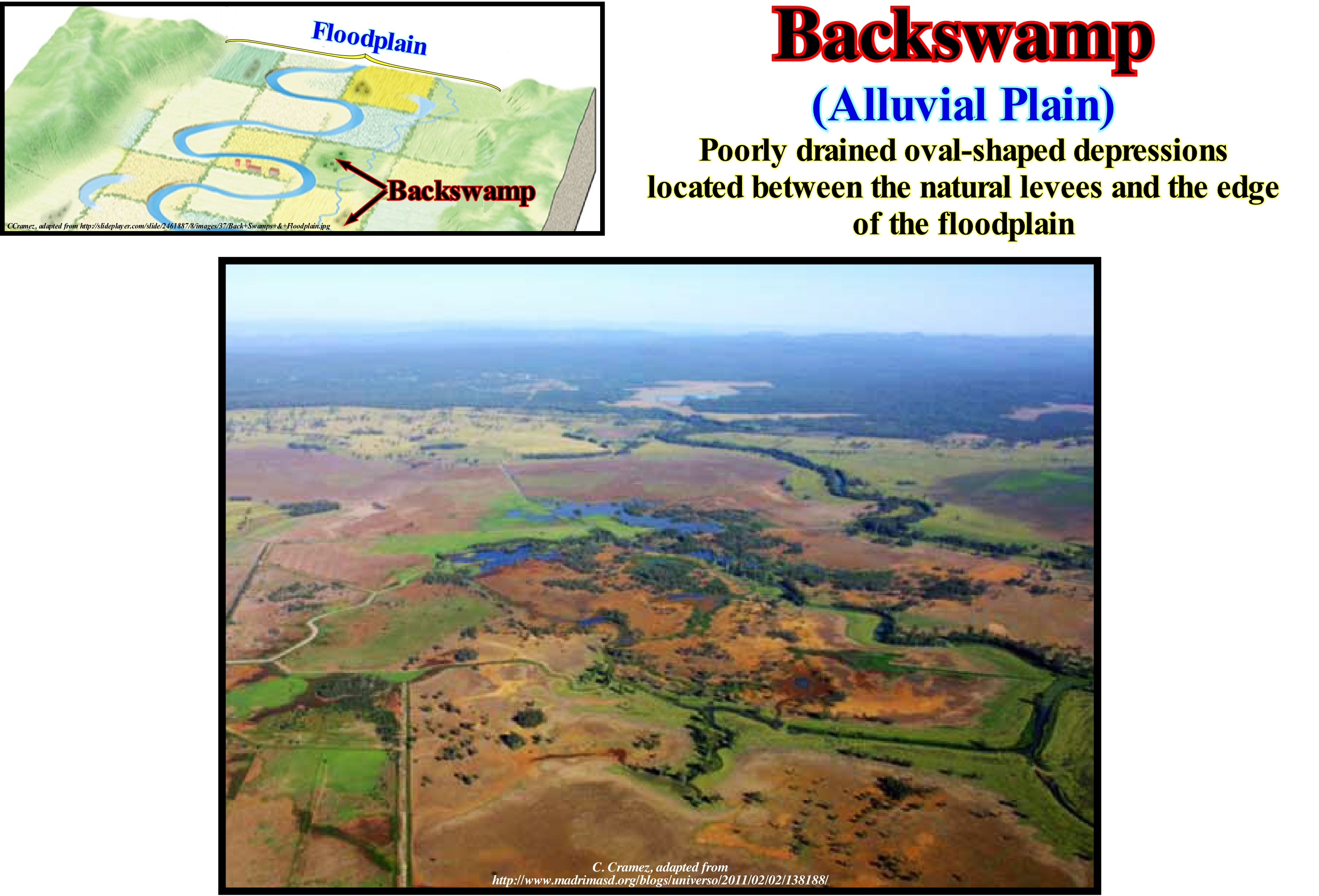
Backswamps (marshes of alluvial plain) unlike coastal marshes form, generally, far from the shoreline, but in direct association with the rivers, in which currents tend to overflow during flood periods. In fact, a backswamp corresponds to the low zones of the flooding surface of the river with which it is associated. Generally, a backswamp is, slightly, lower than the alluvial fans deposited on each side of the river valley, and also lower, than the natural levees (natural fluvial marginal dykes) that form on either side of the river channel. It can be said that these marshes (wetland dominated by herbaceous rather than woody plant species*) are located in a depocenter of siltstones and clays. The floodplain, on which a marshy area where flood-water can be confined between the valley walls, during its formation, is characterized by meandering currents, oxbow lakes, dams, backswamps and it, occasionally, may be covered, completely, with water. When the drainage system ceases to act or is, entirely, diverted, for any reason, the flood-plain can become an area of great fertility, similar in appearance to the bottom of an ancient lake or swamp. Unlike the bottom of a lake or swamp, the flood-plain is, rarely, flat. It slopes towards the river, but, locally, it can lean towards the river bed. This photograph (Vietnam) illustrates a backswamp associated with the Mekong River, which is one of the twelve longest rivers in the world. In this area, the hydrology of the river and its tributaries, is very dependent on the seasons. The maximum flow during the rainy season is about fifteen times higher than during the dry seasons. Most of the flood-plains of low and medium Mekong, are subject to flooding. In many depressions, behind natural levees (fluvial marginal dikes), semi-permanent water-bodies of water (marshes) are formed whose surfaces and depths vary according to the seasons. Sometimes they are, totally, isolated from Mekong tributaries. These marshes are seasonal and their size ranges from one hectare or less, up to hundreds of hectares in extent. They are important fishing sources for the surrounding communities.
(*) This form of vegetation is what differentiates marshes from other types of wetland such as swamps, which are dominated by trees, and mires, which are wetlands that have accumulated deposits of acidic peat.
Backwash Current......................................................................................................................................................Courant redescendant
Corrente de Refluxo (corrente de pré-praia) / Corriente de reflujo / Rückspülung / 反冲洗 / Обратное течение / Corrente di controlavaggio, Risacca /
Swash current moving seaward, following the slope of the sea-floor. It results from the inversion of the uprush current, due to the loss of energy caused by the slope of the sea-floor and the friction along it. Synonym of Backwash Current Tract.
See: « Backwash Current Tract »
&
« Surge Current »
&
« Shoreface »
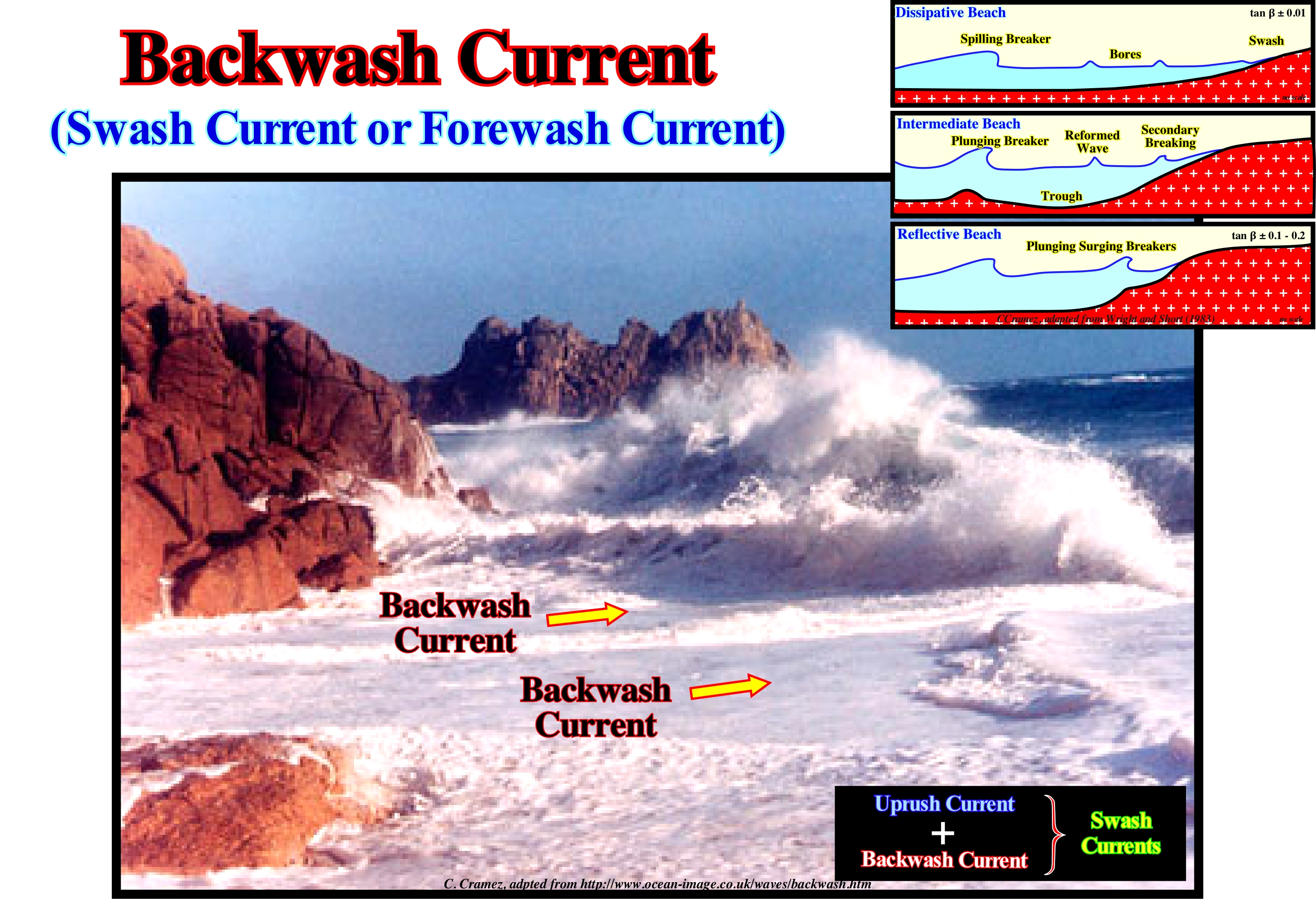
In this picture, the two swash or forewash currents (certain geoscientists say surf currents), i.e., the uprush current, which flows to the coast, and the backrush current, which moves seaward are, easily, identified. The direction of the uprush current is perpendicular to the direction of the waves. The direction of the backrush current is determined by the slope of the beach. Do not confuse the backrush current with the undertow current, whose existence is much discussed, but that is, sometimes, defined as the current traveling along the sea-floor flowing outward. When the material that forms the beach is very coarse, the backrush current is unimportant because there is a significant percolation (slow and laminar movement of the water through the sedimentary material). In this case the slope (dip) of the beach is, relatively, strong and the balance between the uprush and backrush currents is difficult to maintain. Function of the slope the beaches were classified (Wright and Short, 1983) in three types: (i) Dissipative ; (ii) Intermediate and (iii) Reflective, as illustrated Wright and Short (1983) considered different types of beaches showing dissipative, intermediate, and reflective beaches*. When the wave-height is significant (strong energy), i.e., when the waves are destructive, the associated uprush currents are weak, but the backrush currents are strong and have a significant erosive power. Conversely, when the energy and wave-height are small, i.e., when sea-waves are constructive, the associated uprush currents are strong and the backrush currents are weak. It can be said that a backrush current moves toward the crest of the next wave and that the same orbital motion (movement of an object in an orbit around a fixed point), which causes the rise and fall of an object floating in the sea, forces the trough of the of a wave to move backward and upward towards the next crest. Thus a backrush current has nothing to do with a undertow (assuming it exists in nature). The velocity of the waves means a phase velocity. What moves is not the water but the crest and the trough, that is, the phase of the surface of the water.
(*) According Wright & Short (Morphodynamic variability of surf zones and beaches: A synthesis, Marine Geology, vol. 56, Issues 1-4, April 1984, pp. 93-118): (i) On reflective beaches, incident waves and sub-harmonic edge waves are dominant, (ii) In highly dissipative surf zones, shoreward decay of incident waves is accompanied by shoreward growth of infra-gravity energy ; in the inner surf zone, currents associated with infra-gravity standing waves dominate (infra-gravity waves are surfaces gravity waves with frequencies lower than the wind waves – consisting of both wind sea and swell – thus corresponding with the part of the wave spectrum lower than the frequencies directly generated by forcing through the wind with a typical period of 25-250s, frequency of 0.004-0.04 Hz ; (iii) On intermediate states with pronounced bar-trough (straight or crescent) topographies, incident wave orbital velocities are, generally, dominant but significant roles are also played by sub-harmonic and infra-gravity standing waves, longshore currents, and rips. The strongest rips and associated feeder currents occur in association with intermediate transverse bar and rip topographies.
Backwash Current Tract.............................................................................................................................Courant redescendant
Corrente de Pré-praia (corrente de refluxo) / Corriente de reflujo / Rückspülung / 反冲洗 / Обратное течение / Corrente di controlavaggio, Risacca /
Swash current moving seaward, following the slope of the sea floor. It results from the inversion of the uprush current, due to the loss of energy caused by the slope of the sea floor and the friction along it. Synonym of Backwash Current.
See: « Backwash Current »
&
« Surge Current »
&
« Shoreface »
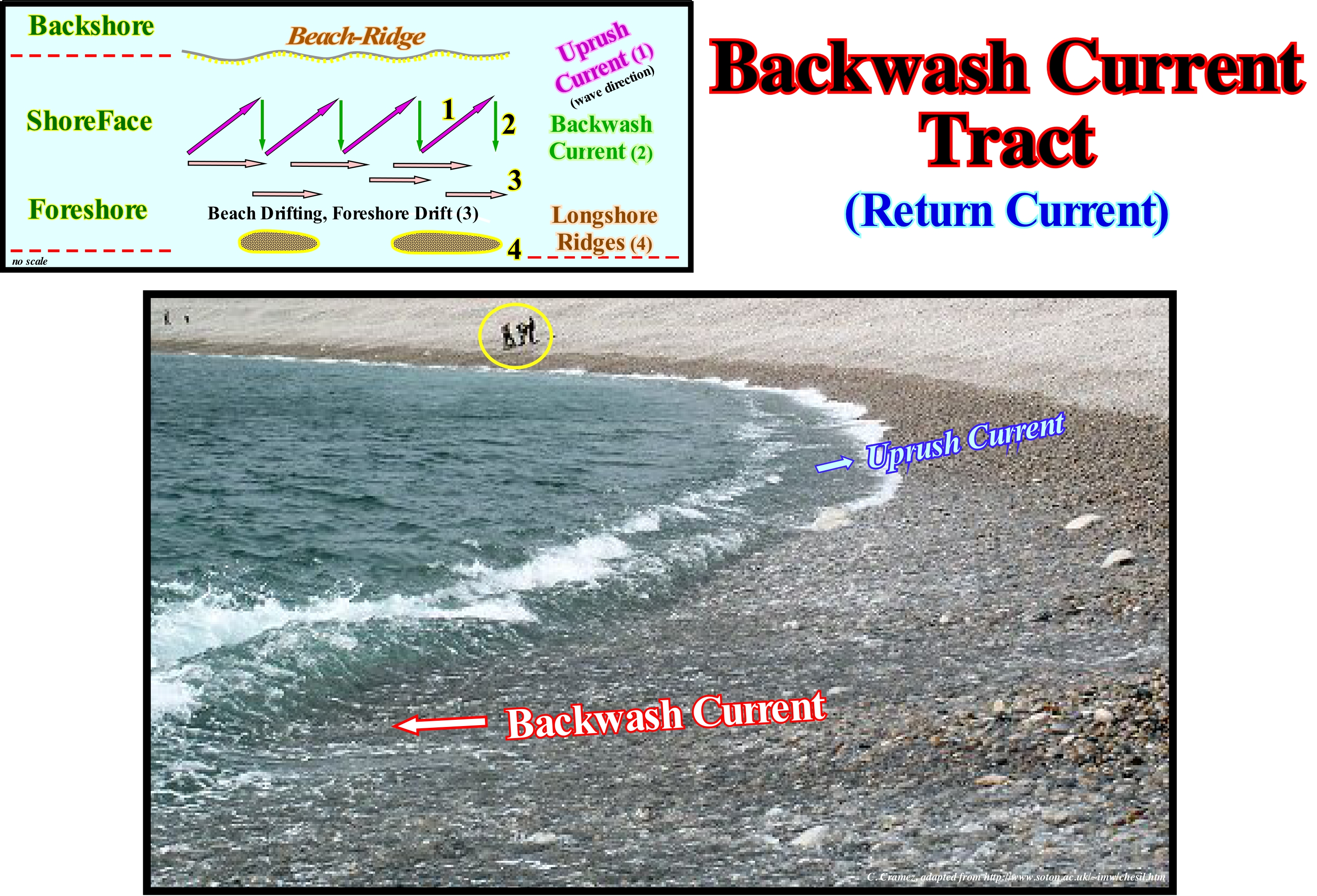
In this picture, the two swash or fore-wash currents (certain geoscientists say surf currents), that is, the uprush current, which flows to the coast, and the backrush current, which moves seaward, are easily identified. The direction of the uprush current is perpendicular to the direction of the waves. The direction of the backrush current is determined by the slope of the beach. Do not confuse the backrush current with the undertow current, whose existence is much discussed, but that is, sometimes, defined as the current traveling along the seabed and flowing outward. When the material that forms the beach is very coarse, the backrush current is unimportant because there is a significant percolation (slow and laminar movement of the water through the sedimentary material). In this case the slope (dip) of the beach is relatively strong and the balance between the uprush and backrush current is difficult to maintain. When the wave height is significant (strong energy), i.e., when the waves are destructive, the associated uprush currents are weak, but the backrush currents are strong and have a significant erosive power. Conversely, when the energy and wave-height is small, the sea waves are constructive and the associated uprush current is strong and the backrush current is weak. It can be said that a backrush current moves toward the crest of the next wave and the same orbital motion (movement of an object in an orbit around a fixed point), which causes the rise and fall of an object floating in the sea, forces the trough of the of a wave to move backward and upward towards the next crest. Thus a backrush current has nothing to do with a undertow (assuming it exists in nature). The velocity of the waves means a phase velocity. What moves is not the water but the crest and the trough, that is the phase of the surface of the water.
Bacteria.................................................................................................................................................................................................................................................Bactérie
Bactéria / Bacteria / Bakterien / 菌 / Бактерия / Batteri /
Simple cell or non-cellular organism that reproduces by binary fission (simple bipartition or cissiparity). Bacteria occur in three fundamental forms: (i) Spherical or sub-spherical form, such as coccus ; (ii) Rod form, such as bacillus and (iii) Spiral form, as spirillium.
See: « Viruses »
&
« Cyanobacteria »
&
« Anoxic (environment) »

Bacteria can cause serious diseases in humans and animals (such as Leptospira, which causes serious illness in cattle). Other bacteria, such as actinomycetes, produce antibiotics (streptomycin, nocardicin, etc.), while others live in symbiosis in the viscera of animals (including humans) or in other parts of bodies, or on the roots of certain plants converting nitrogen into a usable form. Bacteria are used in the manufacture of yoghurt and bread. They help to decompose dead organic matter and are at the base of the food chain of many environments. Bacteria are important because of their extreme flexibility, ability to grow (very fast), reproduction and durability. The oldest known fossils (about 3.5 Ga) on the surface of the Earth are fossils of organisms similar to bacteria. It may seem surprising bacteria may have left fossils. However, a particular group of bacteria, the cyanobacteria* or blue-green algae, have left a fossil record extending far behind the Precambrian. Cyanobacteria are protokaryotes (cells that do not contain nuclei, cells with a nucleus are eukaryotes) photosynthesizers that appeared at about 3.5 109 Ga and still thrive today. The process of photosynthesis of cyanobacteria, which is different from that of photosynthetic bacteria, produces free oxygen and can be translated by the following chemical reaction: 6CO2 + 6H2O + energy↔C6H12O6 +6O2 ± 7,1 eV (volt electrons). This reaction is done to the right during photosynthesis and to the left during respiration (biooxidation of the reduced organic substances and not breath). Cyanobacteria are larger than most bacteria and can secrete a thick cell wall. Cyanobacteria can form large laminar structures, called stromatolites dome-shaped) or oncoliths (when rounded). These structures form like a carpet in aquatic environments, trapping sediments and sometimes secreting calcium carbonate.
(*) Cyanobacteria, which were the earliest forms of life on Earth, between 3.3 and 1.5 Ga, were developed in domed structures called stromatolites consisting of alternating levels of organic and inorganic matter. Structures of this type can be observed on several coastlines, particularly in the Bahamas and Australia. Many geoscientists consider that cyanobacteria, which perform photosynthesis, were responsible not only for the reddish colouring of the earth's surface, but especially for the first major biotic crisis. They admit that the oxygen released by the cyanobacteria was fixed by the iron of the rocks, which probably gave a reddish coloration to the pristine terrestrial surface and that from a certain moment, the oxidation of the rocks, allowed the accumulation of oxygen not only in the atmosphere, but also in the oceans, which certainly triggered a major biotic crisis.
Baltica............................................................................................................................................................................................................................................................Báltica
Baltica / Baltica / Baltica / 波罗 / Балтика / Baltica /
Old continent that presently corresponds, more or less, to the Fennoscandia, individualized in the southern hemisphere after the break-up of the supercontinent Precambrian (Proto-Pangea or Rodhinia), around 600 Ga (millions of years ago). Baltica was surrounded, northward, by the Laurentia (North of America) and, eastward, by the South America and Africa.
See : « Pangea »
&
« Rodhinia »
&
« Supercontinent »
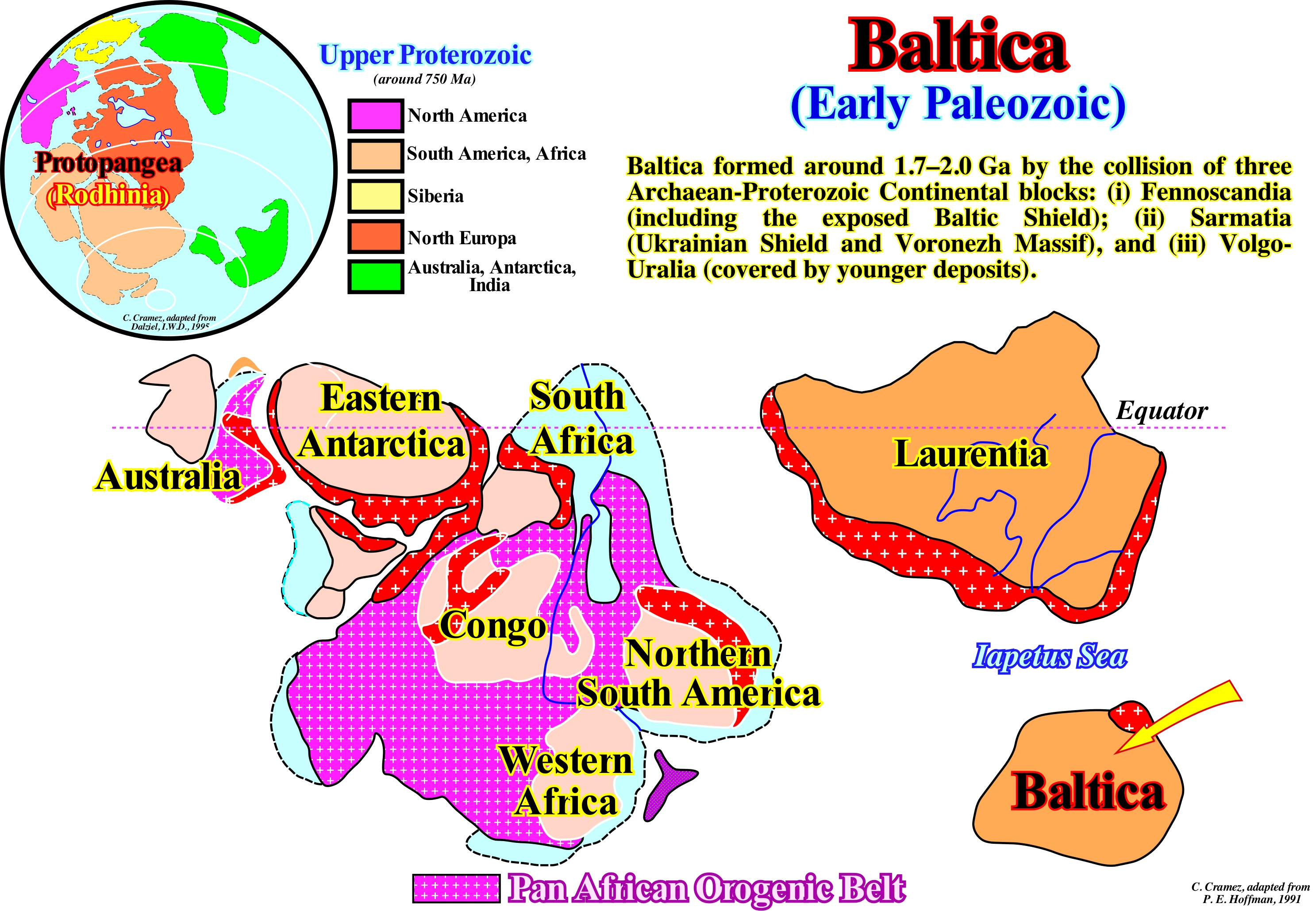
The Late Precambrian supercontinent Proto-Pangea*, also called Rodhinia, was formed by gathering of several pre-Cambrian continents along the orogenic belt of Greenville (1.2 - 1.0 Ga, 109 years ago). The relations between the Greenville orogenesis and Proterozoic rifting** (lengthening), in the central part of Laurentia continent (today corresponds, more or less, to Central and Eastern North America) are still a great mystery. The Greenville's geological event is the collision of the eastern part of Laurentia continent with another large craton consisting of East Antarctica, South Africa, Congo, West Africa and North America which, apparently, later, was a major component of the small supercontinent Gondwana (southern continent of the supercontinent Pangea). Another continental mass that entered the collision was Baltica continent, which is the name of a paleocontinent (old craton), also called Fenno/Sarmatia. It included present-day Scandinavia, the Baltic States and the south coast of the Baltic Sea, north-west Russia, Belarus and northern Ukraine. Of archaic origin (Proterozoic and Phanerozoic), Baltica is individualized as continent, from the supercontinent Proto-Pangea, at the end of the Proterozoic. Most geoscientists think at the beginning of the Phanerozoic, the supercontinent Proto-Pangea, largely, located in the southern hemisphere, break-up in different continental fragments, in particular, Laurentia and Baltica continents that began to move away as new oceanic crust formed between them (oceanic expansion or sea-floor spreading). The oceanic crust was covered by the Ipaetus Sea. This sea existed between 600 and 400 Ma, in the southern hemisphere, between the continent Laurentia (set of what today is Scotland, North America and Greenland) to the West, and Baltic continent (today, the whole of Scandinavia and Eastern Europe) to the East and Avalonia (United Kingdom and Northwest Europe) to the South. The separation of these continents, created by the break-up of the lithosphere of the supercontinent Proto-Pangea, produced a significant reduction in the volume of ocean basins, due to the formation of the great oceanic mountains (oceanic ridges, submarine ridges and mid-oceanic ridges), which accompany oceanization, causing a significant rise of the absolute (eustatic) sea level (supposed to be global and referenced to the Earth's centre via satellite measures***) and the flooding of the margins of the newly formed continents. The volume reduction of the ocean basins was, mainly, induced by the formation of the mid-ocean ridges, between the Laurentia and the Baltica, as Iapetus Sea widened, caused an absolute (eustatic) sea level rise. However, this happen because the amount of water (in all its forms) is constant since the beginning of the Earth's formation (4.5 Ga). To this day, this conjecture has always been corroborated and most geoscientists think it will be difficult to refute it. The history of Baltica continent can be summarized as follows: A) In the Precambrian: 1) Around ± 1.8 Ga, Baltic was part of the supercontinent Columbia ; 2) Around ± 1.5 Ga, it was part of the small supercontinent Nena ; 3) Around ± 1 Ma, it was part of the supercontinent Rodhinia ; 4) Around ± 750 Ma, it was part of the small supercontinent Proto-Laurasia and 5) Around ± 600 Ma, it was part of the supercontinent Pannotia. B) In the Cambrian, Baltic was an independent continent. C) During the Late Ordovician, Baltica collided with Avalonia (a small continent formed from a volcanic arch on the north bank of the small supercontinent Gondwana). D) During the Devonian, Baltic collided with the Laurentia, forming the small supercontinent Euramerica. E) During the Permian, all major continents collided against each other to form the great supercontinent Pangea. F) In the Jurassic, Baltica was part of the small supercontinent Laurasia, which is one of two small supercontinents (the other is Gondwana) that resulted from the breakup of the supercontinent Pangea. G) In the Cretaceous, it was part of the small supercontinent Eurasia. H) Today, Baltica is part of the small supercontinent Afroeurasia.
(*) In Earth's history, geoscientists consider: (i) Supercontinents, such as Pangea or Rodhinia; (ii) Small supercontinents such as Laurasia or Gondwana and (iii) Continents such as the Baltica or Laurentia.
(**) The Proterozoic, on the scale of geological time, is between about 2.5 Ga and 542 Ma, which means that it covers almost half the time of Earth's existence, which has been formed more or less , 4.5 Ga. The Proterozoic is more recent than the Pre-Cambrian supereon (between 4.5 Ga and 542 Ma, it happens to the Archaic or Archaean (between 2.5 Ga and 4 Ga) and precedes the Phanerozoic era: (i) Neoproterozoic, between 542 Ma and 1.2 Ga ; (ii) Mesoproterozoic, between 1.2 Ga and 1.8 Ga and (iii) Paleoproterozoic, between 1.8 Ga and 2.5 Ga. All these dates are approximate since the errors of the measurement method (systematic and random) may be relatively important.
(***) There are basically two types of satellites: (i) The satellites that rotate around the Earth at a few hundred kilometers and (ii) The so-called geostationary satellites that are positioned above the same point at about 36,000 km in height. According to the characteristics of the radiometers of the satellites, the images supplied are at different wave-lengths. There is the visible channel, the infrared channels, the water vapour channel, etc.
Bank (Submarine)...................................................................................................................................................................................................Banc (Sous-marin)
Banco submarino / Banco (submarino) / Bank, Untiefe / 滩 / Залежь (пласт) / Banco di sabbia (sottomarino) /
Prominent submarine landform of the continental platform (shelf) corresponding to an underwater accumulation of sandy coarse sediments or shells. From a biological point of view, a bank is often the biotope or ecotope (place where they live) of colonies of living constructing beings, since it has a certain regularity in environmental conditions.
Ver: " Delta "
Bar...............................................................................................................................................................................................................................................................................Barre
Barra / Barra / Hafeneinfahrt, Barre / 港入口 / Порт входа / Barra di sabbia /
Generic term to designate accumulations of sand, gravel, pebble or alluvium, little or no consolidate, with elongated or lobular geometry and deposited either: (i) At the base or in front of the mouth of a river ; (ii) In a lake or (iii) In the sea (neritic zone).
See: « Neritic »
&
« Delta »
&
« Point Bar (model) »
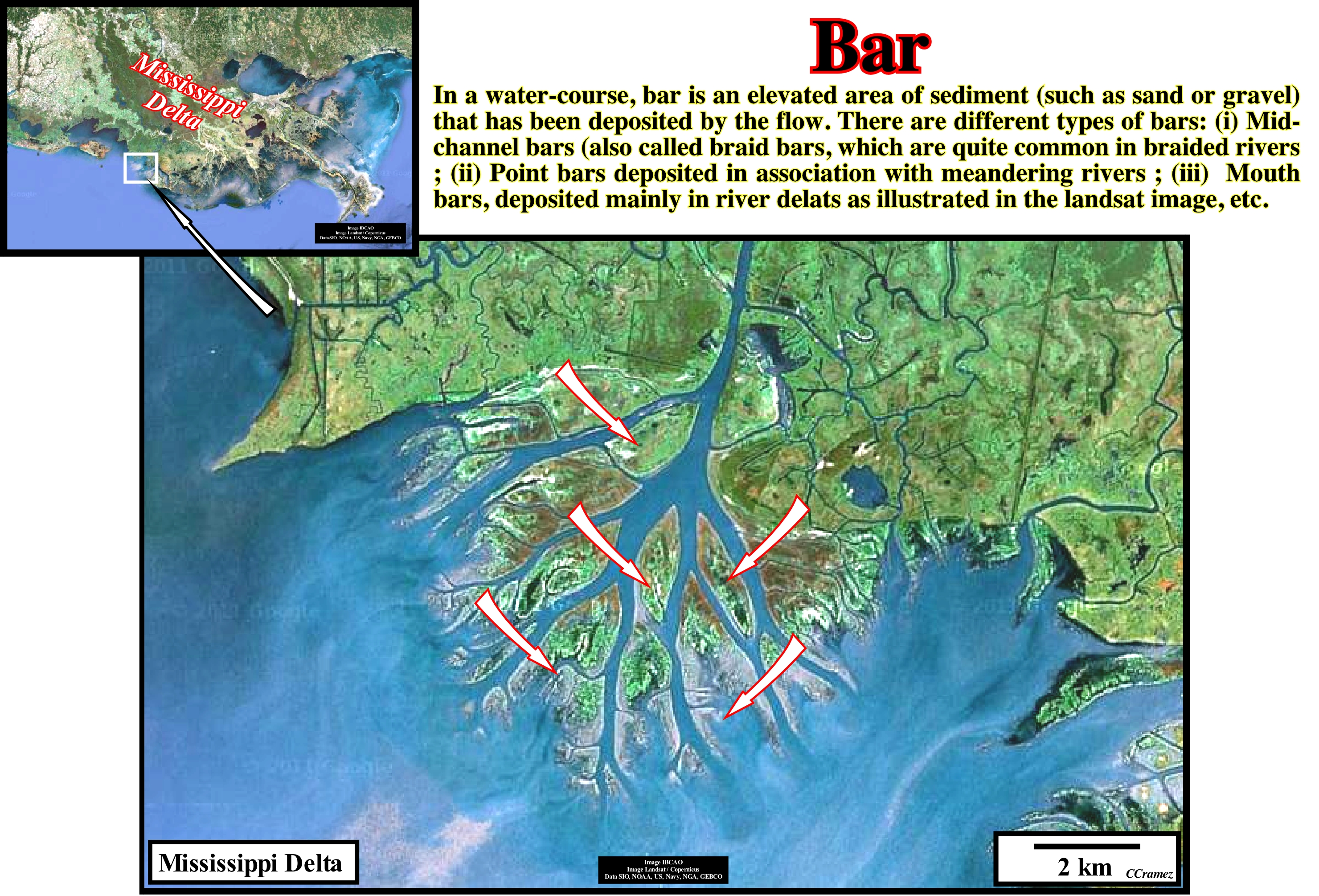
This image shows a complex of bars, in this particular case, mouth-bars, located in front of a, partially, abandoned distributive of the Mississippi River. On conventional seismic lines, used in hydrocarbon exploration, the bars are hardly visible, since their dimensions are, generally, smaller than the seismic resolution. On the contrary, in the electrical logs, which have a very fine resolution, bars are, easily, recognized by the geometry of the gamma ray (GR)* and spontaneous potential (SP)** logs. They emphasize the thickening and coarsening upward characteristics of the bars. This geometry is, almost always, corroborated by the dipmeter log. It suggests, from the bottom to top, increasingly dips underlying an higher depositional energy upward. In outcrops, as well as, in electrical logs, when the depositional system is abandoned and fossilized by more recent sediments, the upper part of the bars can be, locally, eroded by the distributaries. The channels through in which the distributaries flow are, generally, filled, later, by sediments with sandy facies (rarely a distributive channel is filled, entirely, by sediments whether sandy or clayey). In electrical logs, and particularly, in the dipmeter, this situation is, easily, recognized since the thinning and finning upward geometry of the distributive channel fillings, replaces, locally, the thickening and coarsening upward geometry of the bars. The term bar is, colloquially, used to designate the narrow passage of a river port, which does not seem very correct, once most of the bars (sand accumulations) has to be dredged to allow access to the river port. In reality, it is the silting-up of the bed and the mouth of rivers caused by the accumulation of sand material, that creates the bars. In geology, for example, the Douro river bar, in the city of Porto (Portugal), is the accumulation of sand and not the inlet the river (seaward passage of the river).
(*) The radioactivity of rocks has been used for many years to help derive lithologies. Natural occurring radioactive materials (NORM) include the elements uranium, thorium, potassium, radium, and radon, along with the minerals that contain them. There is usually no fundamental connection between different rock types and measured gamma ray intensity, but there exists a strong general correlation between the radioactive isotope content and mineralogy. Logging tools have been developed to read the gamma rays emitted by these elements and interpret lithology from the information collected. (https://petrowiki.org/Gamma_ray_logs)
(**) The SP curve is a continuous recording vs depth of the electrical potential difference between a movable electrode in the borehole and a surface electrode. Adjacent to shales, SP readings, usually, define a straight line known as the shale baseline. Next to permeable formations, the curve departs from the shale baseline. In thick permeable beds, these excursions reach a constant departure from the shale baseline, defining the "sand line." The deflection may be either to the left (negative) or to the right (positive), depending on the relative salinities of the formation water and the mud filtrate. If the formation-water salinity is greater than the mud-filtrate salinity (the more common case), the deflection is to the left. (https://petrowiki.org/Spontaneous_(SP)_log)
Barrier-Bar (Backshore bar)..............................................................................................................................................................Cordon littoral
Cordão Litoral / Cordón litoral, Barra / Nehrung, Strandwell / 障碍海滩 / Береговая линия / Barriera di spiaggia /
Accumulation of sand or pebbles formed in the backshore (a form of relief that constitutes the inner boundary of the beach, which may be a cliff or a barrier-bar insulated or not an interior lagoon). A barrier-bar is, generally, the result of the accumulation of sediments by waves and wind.
See: « Delta »
&
« Depositional Environment »
&
« Shoreface »
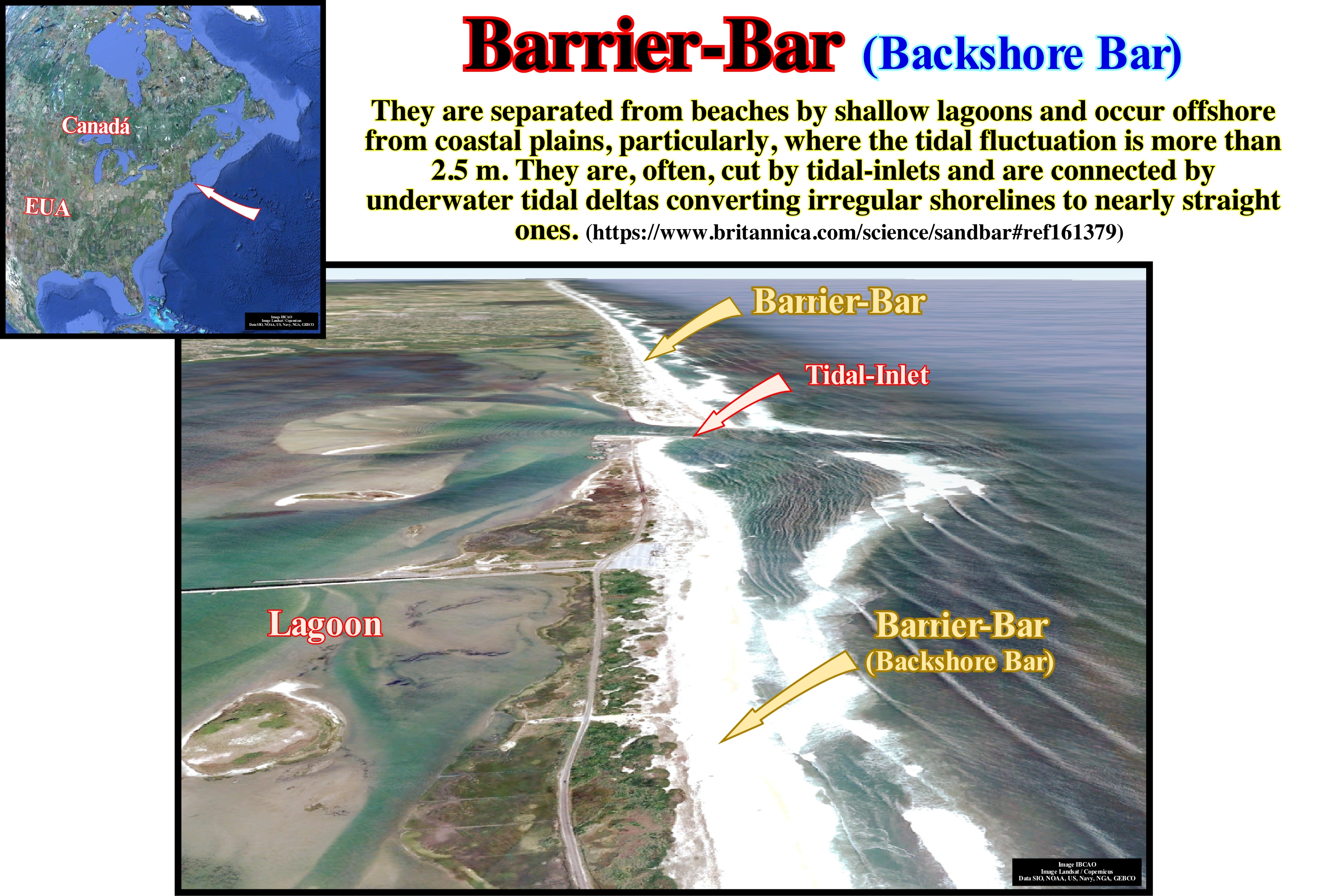
Landward, in this image (taken during low-tide) it is easy to recognize: (i) A chain of barrier-bars with several tidal-inlets (openings), in the intra-tidal zone ; (ii) Backshore (between the berm and the frontal dune) ; (iii) A vegetation grazing zone ; (iv) A forest zone ; (v) The high-marsh and (vi) The low-marsh (low swamp). It can be said barrier-bars are sand or gravel islands, more or less, isolated, parallel to the shoreline and separated from the mainland by a bay, lagoon, swamp or tidal plain*. Barriers-bars are built by waves or wind. In sedimentary environments dominated by waves or in mixed environments, barriers-bars form micro-tidal sedimentary environments (tidal rages less than 2 m) or meso-tidal (tidal range between 2 and 4 m). Barriers-bars form, almost always, chains, where they area separated from the neighbours by tidal-inlets or openings, as illustrated in this figure. The number of bars in a chain reflects the combined action of sea-waves and tides. Very strong wave energy tends to close the inlets, while strong tidal flow tends to open them. A shoreline reflects the hydrographic regime that controls the size and quantity of barrier bars. Storms produce, often, barrier bars. The tides keep the tidal-inlets opened and the waves carry the sediments forming the bars. The balance of these processes determines the length of the barrier bars and the number of tidal inlets along the coastline. The very long barrier bars are formed, preferably, in areas characterized by low-tides and moderate to strong wave energy. The width of a barrier bar reflects, fundamentally, the sedimentary charge, the changes of the relative sea level and the regime of the winds. A relative sea level rise causes erosion and, when the terrigeneous influx is insignificant, the barrier-bars are displaced continentward. Some people, even geoscientists, confuse the barrier bar with the tidal inlet that they call the bar. This is the case, for instance, near the Oporto city (Portugal) where many people call bar the tidal-inlet, which is, in this particular case, the mouth of Douro river.
(*) Tidal environments occur in a wide variety of settings (e.g., directly facing the open sea/ocean, in estuaries, in lagoons behind barrier islands, near tidal-inlets) and contain a supratidal zone, an intertidal zone (tidal-flats), and tidal channels. Function of the tidal range different sedimentary environments can be considered: (i) micro-tidal (less than two metres); (ii) meso-tidal (two to four metres) and (iii) macro-tidal (more than four metres).
Barrier-Beach..............................................................................................................................................................Plage-barrière (Cordon littoral)
Praia-Barreira / Playa-barrera / Barriere Strand / 屏障海滩 / Барьерный берег (береговая линия) / Barriera spiaggia /
Form of accumulation of sand and/or pebbles developed in the backshore due to the deposition of sediments transported by the waves. A barrier-beach is oriented, more or less, parallel to the shoreline and is not, usually, submerged during the tides. Also called, by certain geoscientists, Barrier-Bar.
See: « Beach »
&
« Littoral »
&
« Coastal Karst »
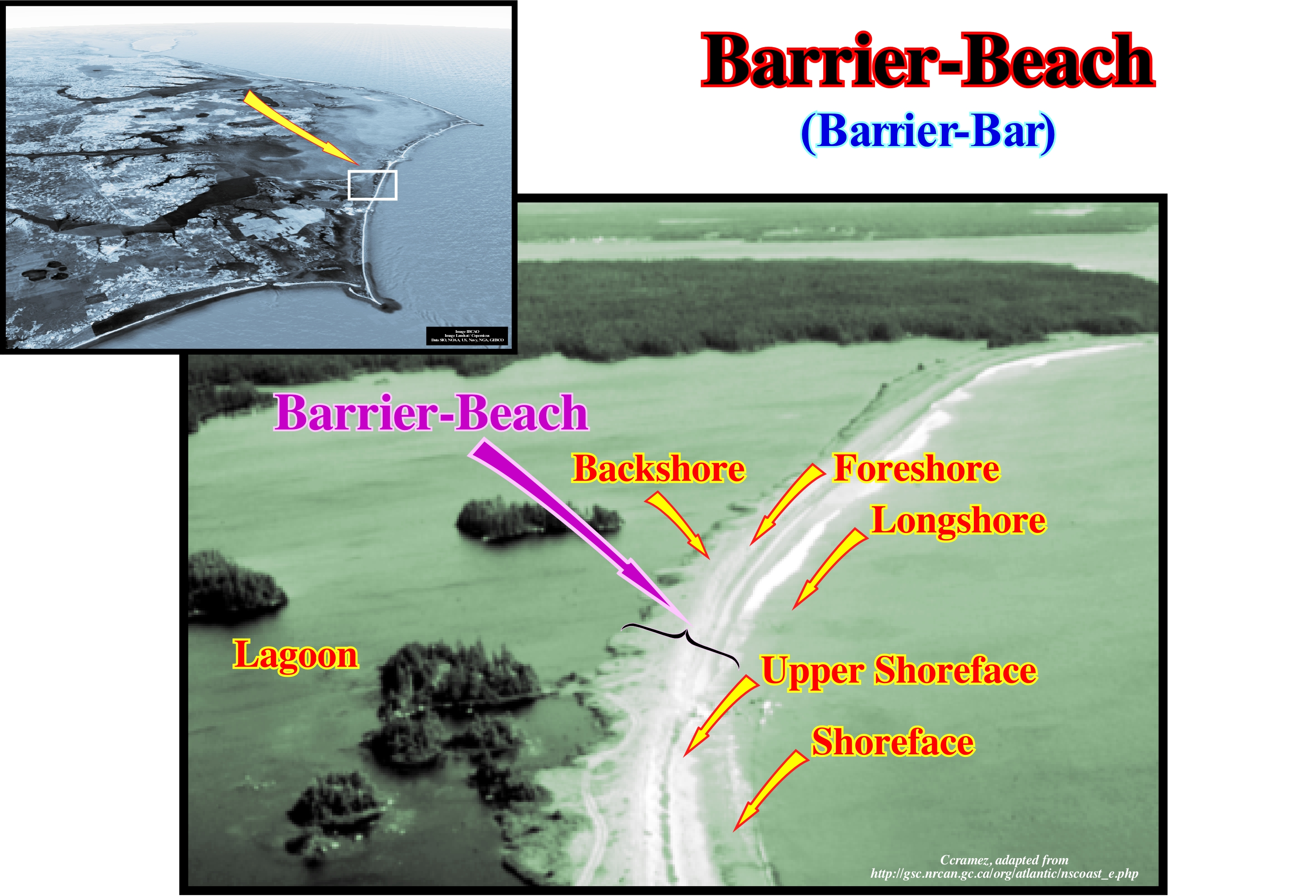
This image illustrates an example of a barrier-beach in Nova Scotia (Canada). In this particular case, the relief that constitutes the backshore (inner limit of a beach) is a barrier-bar that isolates a lagoon. The different strips that form the beach, that is, (i) Backshore ; (ii) Foreshore ; (iii) Upper shoreface (nearshore); (iv) Shoreface and (v) Longshore, are easily recognized. The longshore, which is the part of the ever-submerged beach, stretches outwards from the lower tide boundaries and corresponds, more or less, to the surf wave zone. As you can see above, this barrier-beach is arched. Its curvature can be defined by the radius of the circle whose string is the segment of line that joins the extreme points of the beach. In this area of Canada, coastlines are dynamic and the rate of change is, largely, dependent on the type of coast and a number of local conditions, such as: (a) Sea wave energy ; (b) Tidal amplitude ; (c) Presence of ice, etc. The terrigeneous influx (coming from the onshore or the surrounding coast) determines the stability of the beaches or the water front. When sediments are available, the beaches are built and prograde seaward. When the terrigeneous influx is limited, the beaches are eroded and migrate to the mainland and, often, disappear completely. The barrier-beach illustrated in this figure protects from the sea a large lagoon, as well as the houses, probably secondary residences, constructed in the small islands that are seen in the lagoon. At least in this area, the coastlines, which are very dynamic, have a morphology that varies, quickly. They are formed by barrier- beaches, with water on each side and coastal cliffs composed of stones and till (glacier deposits). In this area, these depositional areas are, highly, sought as places to build secondary houses, especially country houses. Unfortunately, both barrier-beaches and coastal cliffs are vulnerable to relative sea level changes and, over time, they undergo important morphological variations. In general, it can be said barrier beaches have an important role as geomorphological features in their own right. They provide natural protection to extensive areas of wetlands. In certain areas, large scale roll-back of the barrier can occur with displacements of 80-100m occurring in a single storm event, what cause instantaneous loss of large areas of environmentally important intertidal areas and may also have a dramatic impact on built infra-structure. Occasionally, the formation of a permanent or semi permanent tidal breach may occur (Understanding barrier beaches R&D Technical Report FD1924/TR) when the barrier reaches a stage of breakdown; this may cause significant changes to the morphological and ecological evolution of the area to landwards.
Barrier Coast........................................................................................................................................................................................................................................Lido
Lido (costa) / Lido / Nehrung / 障壁海岸 / Береговой вал / Lido /
Coast where the processes of accumulation predominate forming spits, barrier islands and barrier-bars that, often, isolate lagoons.
See: « Barrier Bar »
&
« Lagoon »
&
« Coast »
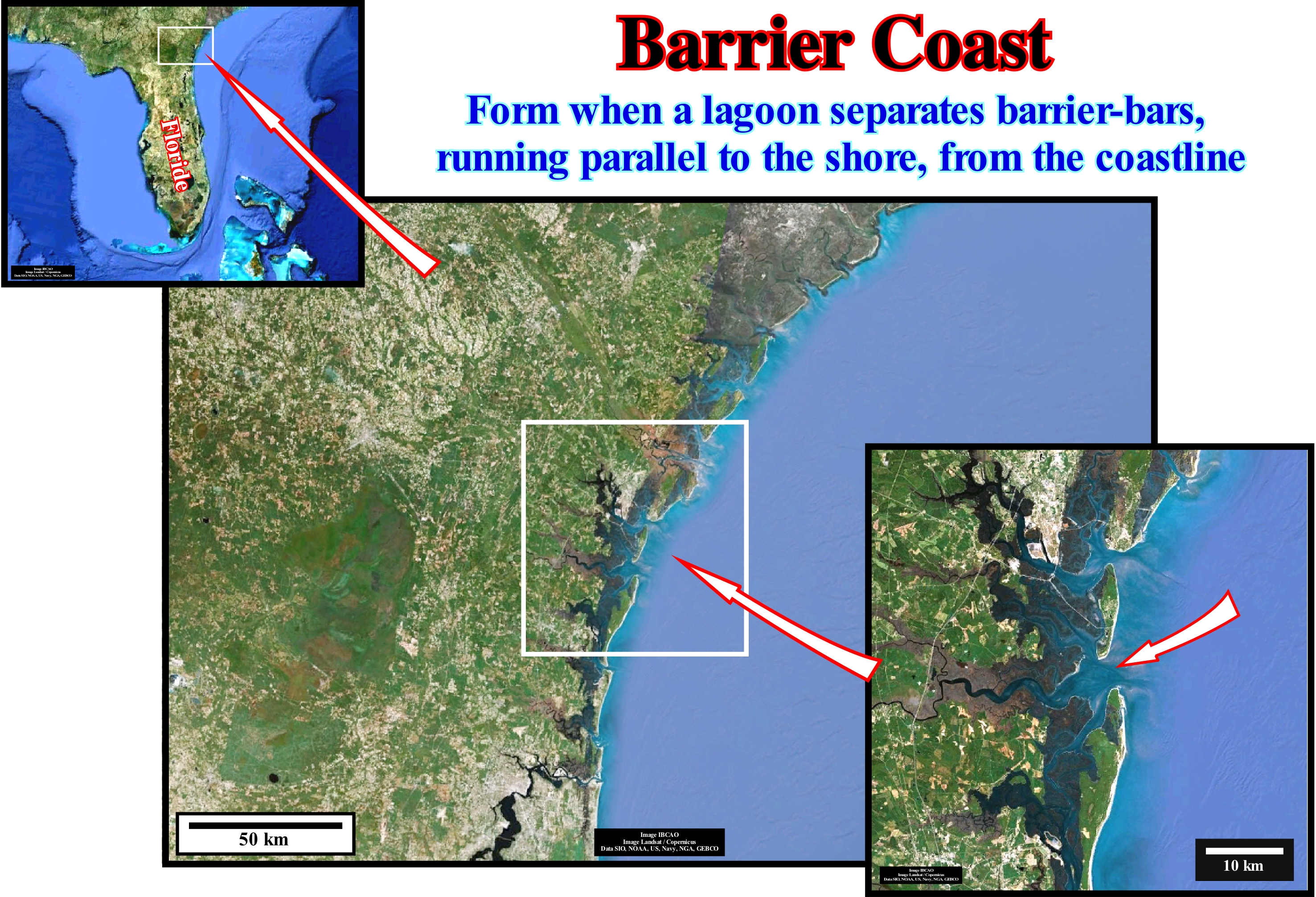
As illustrated in this figure, the east coast of the United States and particularly the coast of Georgia, is of the typical barrier coast. Sandbars and barrier-bars are found along almost the entire east coast of the United States. From Florida, north of Maine, they change dramatically in morphology. Many of Georgia's barrier islands are among the oldest. Geologically, the barrier-bars are, considerably, younger than the mainland. Some have formed about 30,000 years ago, others have emerged only in the last 5,000 years. Sandbanks are not just part of a continent surrounded by water. These geological bodies continually change due to the forces of the winds, ocean currents, waves, storms and tides. The tides have the greatest impact on the evolution of the these barrier-bars or barrier islands. The East coast of Georgia is the western extremity of a great convergence of the ocean. The tides are higher higher (1.8 - 2.4 meters) and faster than anywhere else on the coast. This type of coast is found in many parts of the globe and, particularly, in the SE of Ireland where several sandstone spits and barrier-bars with gravel have been deposited, encloses, more or less completely, lagoons and estuaries. The evolution of each of these sedimentary bodies depends on the terrigeneous influx, that is, relatively, limited and on the longshore drift derived from the swell (deformation of the sea surface caused by the propagation of the waves). Each beach forms a distinct sedimentary compartment, which is a closed system of coastal drift. Locally, overbanking processes can dominate the dynamics of the barrier-bars. At the end of the spits, the wind accretion of the beach crests is an important mechanism to develop recurvated spits. For many geoscientists, barrier-bars are defined as elongated sand islands, essentially, parallel to the coast, usually, with dunes, separated from the mainland by a salt marsh or pond and separated from each other by bays. The term barrier identifies them as buffers that protect the continent from the bursting force of the waves.
Barrier Reef...............................................................................................................................................................................Récif barrière (Récif avancé)
Recife Barreira / Arrecife barrera / Barriereriff / 堡礁 / Барьерный риф / Barriera di scogli /
Reef built near the shelf edge (may or not coincide with the basin edge), and which, completely or partially, isolates a lagoon from theopen sea. In a barrier reef there may be passages or inlets (openings) between the open sea and the lagoon.
See: « Reef »
&
« Transgressive Interval »
&
« Deposition (carbonates) »
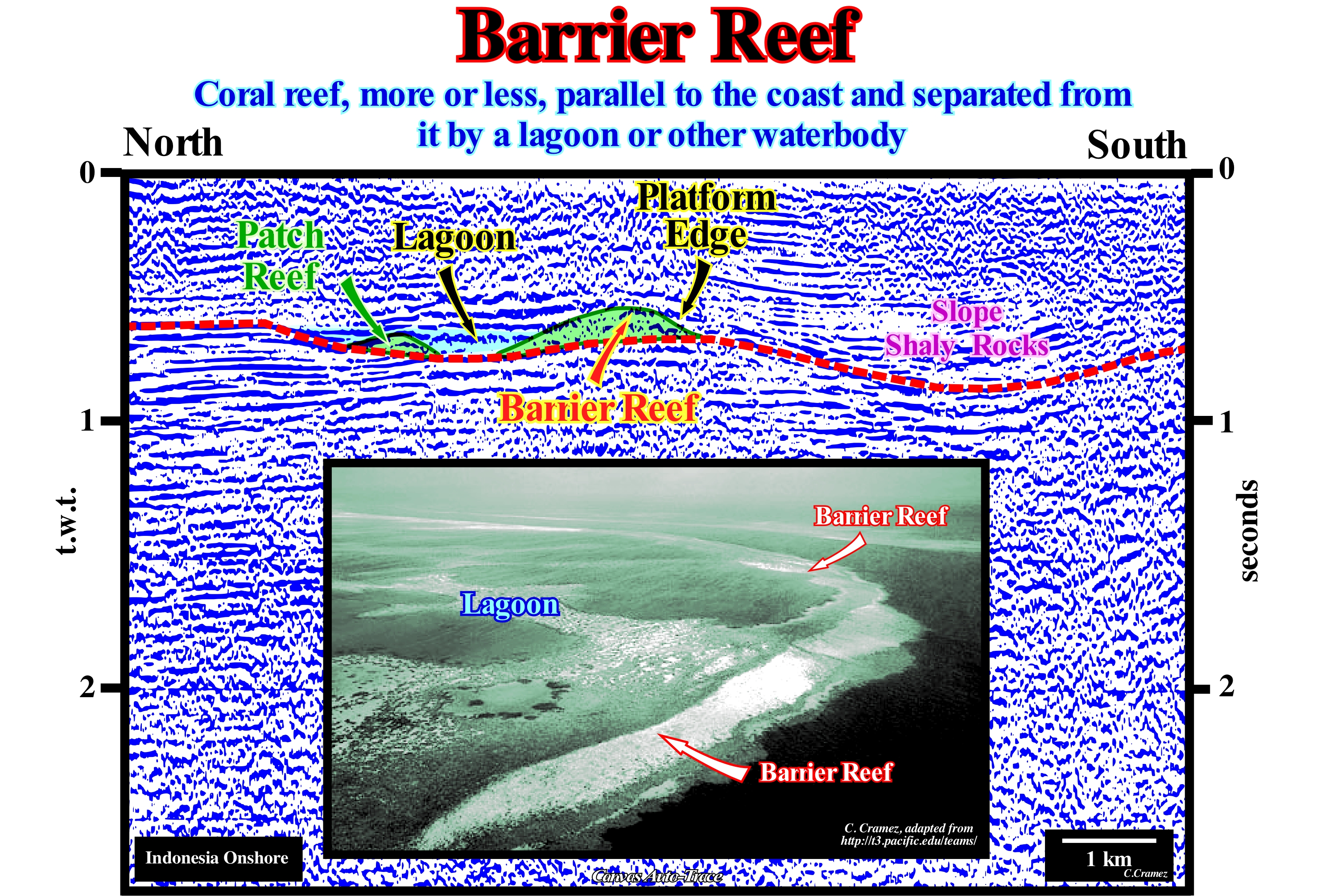
A reef is formed by several species of corals, which are animals of the group of coelenterates ("cele" means hollow and "enteros" means intestine), which have a digestive cavity and secrete a limestone exoskeleton along with calcareous algae that produce fine calcium carbonate slabs that accumulate and cement the reef structure. Function of its shape, size and distance to the mainland, the reefs are, generally, classified as : (i) Fringing reefs, which are simple and more or less connected to the coastline (continents or islands), such as those found in the Caribbean and near Florida and Bahamas, which form the most common type of reef ; (ii) Barrier reefs are coral reefs which, in general, grow parallel to each other along the coast, outcropping at low-tides with the formation of lagoon areas or channels between the reef and beach (the typical example is Australia's Great Barrier Reef*, the largest in the world, which extends for more than a thousand kilometers along the Australian coast) and (iii) Atolls, which are ring-shaped structures with a central lagoon, developed in, relatively, deep-waters, generally, on former submerged volcanoes. Barrier reefs are linear or semicircular carbonate constructions, separated from the continent by channels. The barrier reefs are associated with rimmed carbonated platforms and isolated platforms. The first, which are characterized by the presence of reefs and reefal shoals in the edge of the platform, develop in calm waters and its width varies between 10 and 100 km. The latter, which develop, also, in calm waters, are isolated from the mainland and characterized by facies controlled by the orientation of the prevailing winds. On isolated platforms, reefs and sandy bodies form on the windward side (direction from which the wind is coming), as on rimmed platform, with more muddy sediments in the leeward margin (direction in which the wind id blowing). The width of an isolated platform can reach 100 km. Taking into account that: (i) The profile of a carbonated platform is, more or less, sub-horizontal, which contrasts with siliciclastic platforms ; (ii) A barrier reef marks the edge of the platform, either in a rimmed or isolated platform, which may or may not coincide with the basin edge, depending if the basin, at the level of the sequence-cycle, has or not a shelf ; (iii) A barrier reef, separates the lagoon from the open sea ; (iv) The outer margin of the barrier reef is more abrupt and has rough sea characteristics, while the inner margin is less abrupt and has calm sea characteristics ; (v) Isolated reefs or carbonate mounds can develop in the lagoon and (vi) The inner margin of the lagoon corresponds, at least seismically, to the coastline. The Canvas auto-trace of a detail of an Indonesian offshore seismic line (Irian Jaya, Papua), illustrated in this figure, may be tentatively interpreted in geological terms as follows: (a) An unconformity (coloured dotted line in red) induced by a fall in relative sea level (local sea level referenced to any fixed point on the Earth's surface, which can be the base of the sediments or the sea floor and which is the result of the combined action absolute or eustatic sea level absolute, which is supposed to be global and referenced to the Earth's centre and tectonics**) is, easily, identified (the lateral velocity variations between carbonates and slope shale introduces significant pullups and pulldowns), in particular under the barrier reef that isolates the lagoon, where an patch reef (isolated reef) is well seen. The absence of reflectors in the barrier reef suggests a significant porosity, which has not been refuted by the exploration well drill in this target.
(*) An immense range of corals consisting of about 2,900 reefs, 600 continental islands and 300 coral atolls, located between the beaches of north-eastern Australia and Papua New Guinea, which is over 2,200 kilometers long, ranging in width from 30 km to 740 km. (/https://en.wikipedia.org/wiki/Grande_Barreira_de_Coral)
(**) Subsidence when extensional tectonic regimes are predominant or uplift, when compressive tectonic regimes are predominant.
Baryonic Matter........................................................................................................................................................................Matière baryonique
Matéria Bariónica / Materia bariónica / Baryonischen Materie / 重子物质 / Барионическое вещество / Materia barionica /
Matter composed mainly of baryons*, which includes atoms of all kinds (almost all matter that we can find in everyday life). The distinction between baryonic and non-baryonic matter (neutrinos, free electrons, etc.) is very important in cosmology, because the Big Bang nucleosynthesis models imply a set of restrictions on the amount of baryonic matter present at the beginning of the Universe.
See: « Matter and Antimatter »
&
« Big Bang (Theory) »
&
« Early Universe »
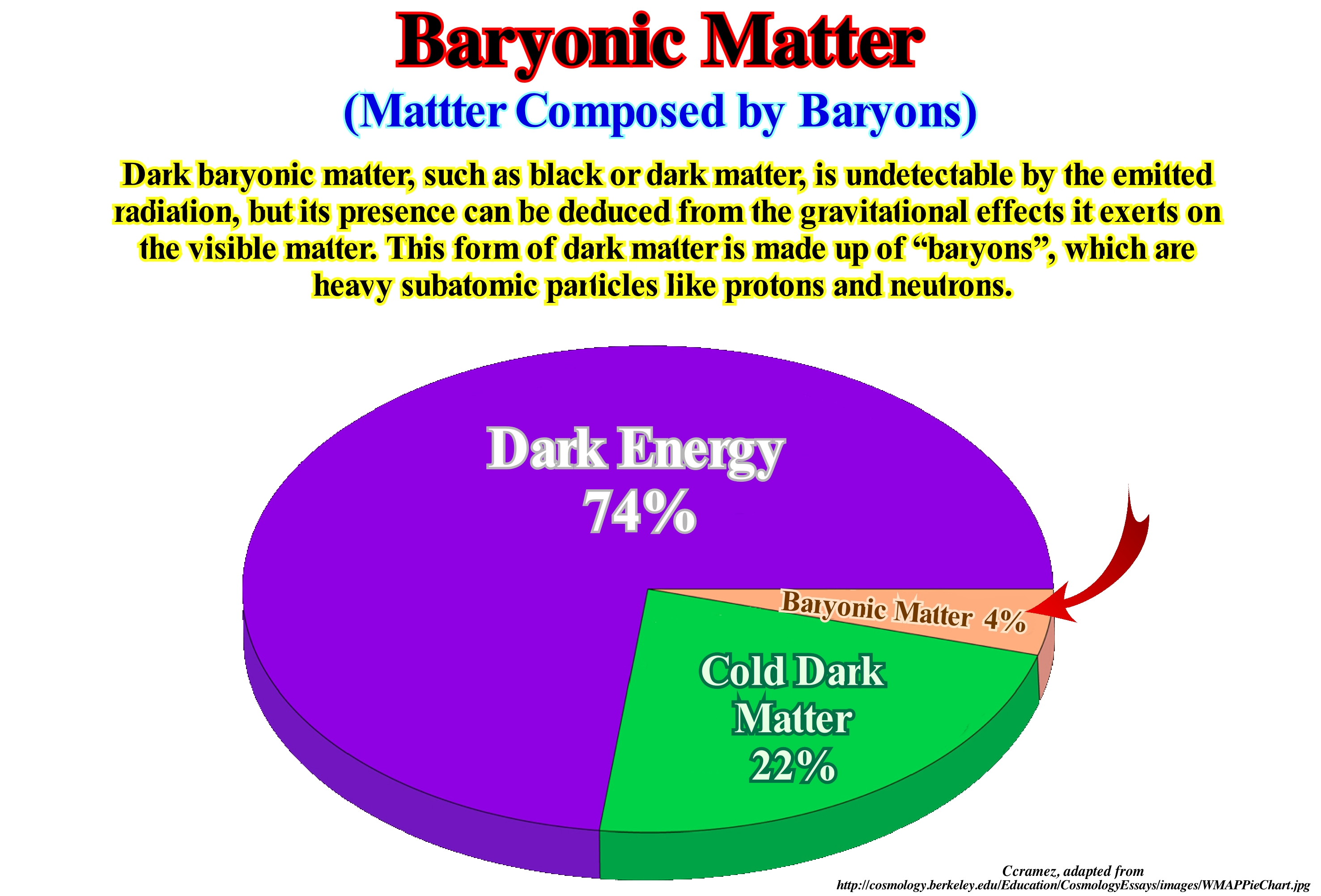
A baryon* is a particle composed of three quarks**. The baryons oppose the mesons, which are made of a quark and an antiquark. Baryons and mesons belong to the family of hadrons, which are the particles made of quarks. The name baryon comes from the Greek word for "heavy", because at the time of its nomination, most of the known particles had masses inferior to those of the baryons. Since the baryons are made up of quarks, they participate in strong interaction. Leptons, on the other hand, are not composed of quarks and, as such, do not participate in strong interaction. The most well-known baryons are the protons and neutrons, which make up most of the mass of matter visible in the Universe, while the electrons (the other great component of atoms) are leptons. Each baryon has a corresponding anti-particle (antibaryon), where the quarks are replaced by their corresponding anti-quarks. A proton is made up of two "up" quarks and a "down" quark and its corresponding antiparticle, the anti-proton, is made up of two "up" anti-quarks and one "down" anti-quark. Baryonic matter is composed mainly of baryons (in mass), which includes atoms of any kind (including almost all matter that we can find in everyday life). Nonbaryonic matter, as the name suggests, is any kind of matter that is not, fundamentally, composed of baryons. This may include common matter, such as neutrinos and free electrons. However, it may also include exotic species of non-baryonic black matter, such as supersymmetric particles, axions or black holes. The distinction between baryonic and non-baryonic matter is important in cosmology, once Big Bang nucleosynthesis models impose constraints on the amount of baryonic matter present in the early Universe. The Universe is full of matter and the attractive force of gravity pulls all matter together. A long time ago, the Universe was, actually expanding, more slowly than it is today. So the expansion of the universe has not been slowing due to gravity, as everyone thought, it has been accelerating. No one expected this, no one knew how to explain it. But something was causing it. Theorists came up with three sorts of explanations: (i) May be it was a result of a long-discarded version of Einstein's theory of gravity, one that contained what was called a "cosmological constant" ; (ii) May be there was some strange kind of energy-fluid that filled space ; (iii) May be there is something wrong with Einstein's theory of gravity and (iv) A new theory could include some kind of field that creates this cosmic acceleration. Theorists still don't know what the correct explanation is, but they have given the solution a name. It is called dark energy (https://science.nasa.gov /astrophysics/focus-areas/what-is-dark-energy). By fitting a theoretical model of the composition of the Universe to the combined set of cosmological observations, scientists have come up with the composition ± 74% dark energy, ± 22% dark matter*** (currently believed to be composed of some kind of new elementary particle, usually referred to as a Weakly Interacting Massive Particle WIMP), ± 4% normal matter (composed of protons, neutrons, and electrons. It comprises gas, dust, stars, planets, people, etc.).
(*) A baryon is an elementary particle that is influenced by the strong nuclear force. The proton and the neutron are baryons.
(**) A quark is a hypothetical particle that has a positive or negative fractional electric charge equal to 1/3 or 2/3 of the charge of an electron that has never been observed in the free state and which appears in combination of three quarks, connected by a strong nuclear force to form a proton or a neutron or attached to an antiquark to form a meson. There are six different species of quarks that are known as: "up"; "down"; "weird" ; "charmed " ; "base" and "top".
(***) Non-luminous material which is postulated to exist in space and which could take either of two forms: weakly interacting particles ( cold dark matter ) or high-energy randomly moving particles created soon after the Big Bang ( hot dark matter ).
Base-Discordance (Unconformity)....................................................................................Discordance de la base (Inférieur)
Discordância da Base / Discordancia de base / Niedrigere-Diskordanz / 较低的差异 / Подошвенное угловое несогласие / Discordanza inferiore, Superficie di deposizione iniziale /
Lower limit of a sequence-cycle upstream of the deep-water correlative paraconformity, i.e, in the area where the relative sea level fall has created, at least locally, an erosional surface. Synonym of Base-Unconformity.
See: « Sequence-Cycle »
&
« Truncation »
&
« Unconformity »
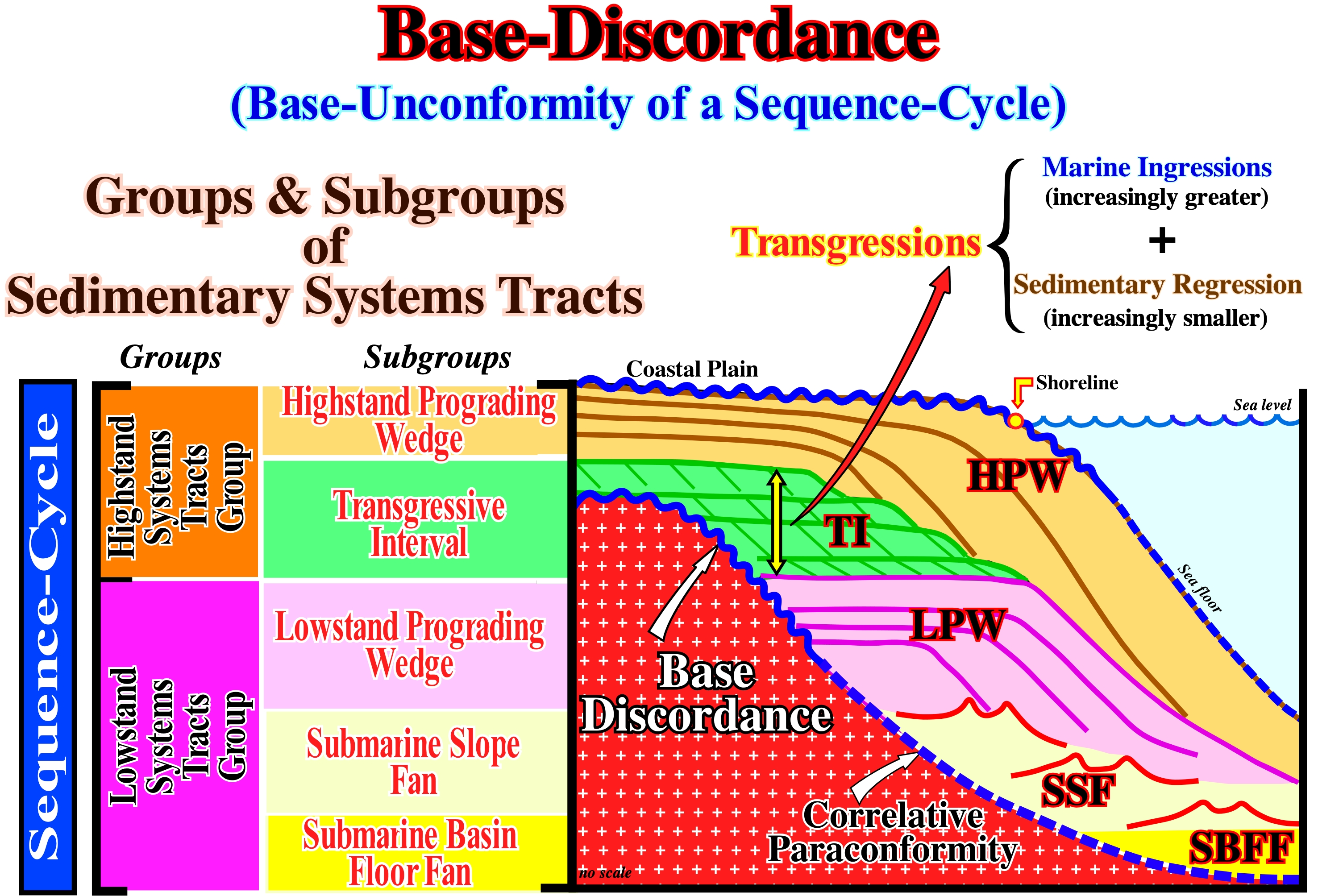
A stratigraphic cycle said sequence-cycle is induced by a 3rd order eustatic cycle, i.e., by an eustatic cycle with a time-duration between 0.5 and 3-5 My (millions of years). Each eustatic cycle is limited between two significant falls in relative sea level (local sea level referenced to any point on the land surface, either the sea-floor or the base of the sediment resulting of the combined action of the tectonics and the absolute or eustatic sea level, which is supposed to be global and referenced to the Earth's centre). Each relative seal level fall creating an erosional surface, the associated stratigraphic cycle is bounded by two unconformities. However, for the most part, the erosion is, relatively, local and limited to particular areas. In the deep parts of the continental slope and in the abyssal plain, there is no erosion associated with relative sea level changes (there may be erosion induced by turbidite currents or contour currents). In the deep areas, as shown in this scheme, the limit of the sequence-cycle is the correlative paraconformity (dash blue trace) that correlates, upstream, with the unconformity (wavy continuous blue trace). Next to the continental edge, which, sometimes, on seismic lines can coincide, more or less, with the shoreline (lowstand prograding wedge, LPW, and 2nd stage of development of the highstand prograding wedge, HPW), the limits of the stratigraphic cycles are easier to recognize. This is true, not only because the onlaps of the lowstand prograding wedge, which fossilize the lower unconformity (base-discordance), are well marked, but also because submarine canyon fills are frequent. Upstream of the basin edge, erosional surfaces are cryptic. However, locally, unconformities (erosional surfaces) can be recognized when incised valley fills are present*. For a given sequence-cycle (associated with a 3rd order eustatic cycle), the basal or lower unconformity is, of course, at the same time, the upper sequence boundary of the underlying sequence-cycle. Within a complete sequence-cycle, as shown in this figure, all sub-groups of sedimentary systems tracts (lateral association of contemporaneous and genetically related depositional systems) are deposited. Within the lowstand systems tracts group (LSTG) from bottom to top, the following subgroups are deposited: (a) Submarine Basin Floor Fans (SBFF) ; (b) Submarine Slope Fans (SSF) and (c) Lowstand Prograding Wedge (LPW). In the highstand systems tracts group (HSTG), from the bottom up, the following subgroups are found: (d) Transgressive Interval (TI) associated with increasingly larger marine ingressions and formed by sedimentary regressions increasingly smaller and (e) Highstand Prograding Wedge (HPW). The basal or lower unconformity is recognized without great difficulty on the base of highstand systems tracts group (highstand prograding wedge and transgressive interval) and on the upper part of the lowstand prograding wedge. On the contrary, in the lower part of the lowstand prograding wedge (LPW) and in the submarine fans (basin and slope fans), the basal unconformity does not exist and therefore the lower boundary of the sequence-cycle is given by the correlative deep-water paraconformity, i.e., it is given by the paraconformity which has the same age unconformity and on which the submarine basin floor fan and submarine slope fan rest. The reflections terminations associated with the submarine slope fan are not true onlaps. They correspond to local downlaps associated with the turbiditic levees (natural marginal dikes). In addition, as they dip in opposite directions, they form sedimentary structures with a particular geometry that Peter Vail called structures in "gull wings." Note that many geoscientists (such as Cesar Emiliani) use the term transgressions to denote the set of increasingly larger marine ingressions and the increasingly smaller sedimentary regressions deposited during the stability periods of the relative sea level occurring after each marine ingression.
(*) Within a sequence-cycle, t incised valley and submarine canyons fills are made during the deposit of the lowstand prograding wedge, when the relative sea level begins to rise, i.e., during the increasing and concave sector of the curve of relative sea level changes (combination of absolute sea level changes and tectonics).
(**) Three-dimensional set of sediments or lithofacies forming part of a sedimentary systems tract of a sequence-cycle. The depositional systems vary according to the type of sediments available for deposition, as well as, with the depositional processes and environments in which they are deposited. The dominant depositional systems are alluvial, fluvial, deltaic, marine, lacustrine and aeolian.
Base Flow (Drought flow, Fair-weather runoff) ............................................................................................................................Débit basal
Escoamento de Base / Flujo basal / Baseflow, Dürre fließen, Rezession Grundwasserfluss / 基流 / Грунтовый сток / Flusso di siccità, Flusso di recessione delle acque sotterranee, Basso flusso, Flusso di acqua bassa, Flusso di base /
Under-ground water entering a channelled stream (river, for example) allowing the continuity of flow, even when it does not rain. Synonym of Base Outflow.
See: « Flux »
&
« River »
&
« Water Table »
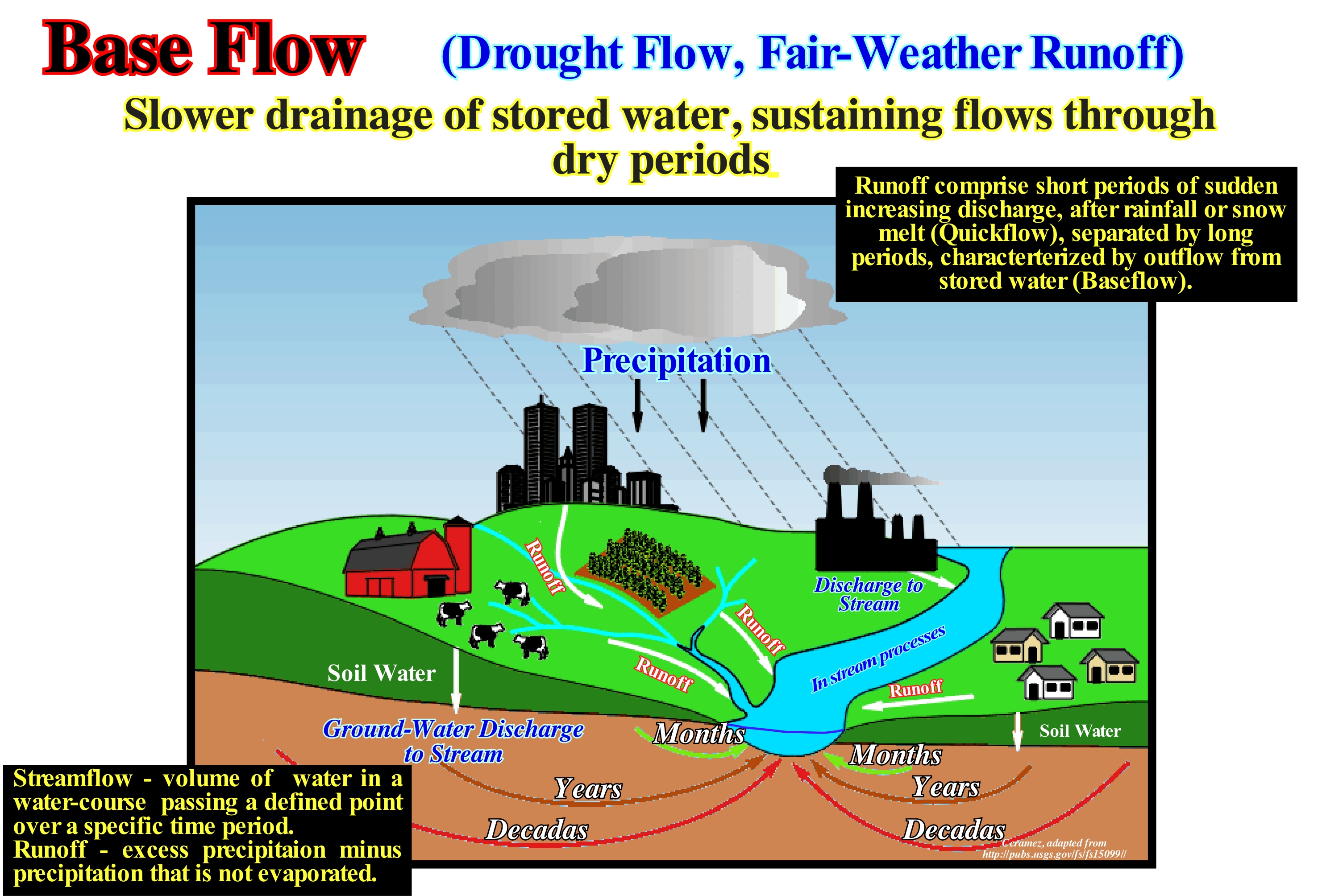
The base flow is the amount of flow of a stream coming from the ground-water (water present beneath Earth's surface in soil pore spaces and in fractures of rock formations) and flowing to the surface. Many geoscientists think that about 50% of the water that seeps into the shallow ground-water contributes to the base flow. The best thing to well understand the geological significance of the basic flow is to consider an example. If we consider the Chesapeake Bay, which is one of the largest estuary of the United States of North America (between Maryland and Virginia) and extends over a surface of about 167,000 km2 and in which more than 150 rivers flow, one can say: (i) Ground-water contributes to more than half (about 54%) of the total annual outfall of the bay drainage basin ; (ii) The amount of nitrate that ground-water contains contributes to about half (more or less, 48%) of the annual amount of nitrogen entering the bay ; (iii) The residence-time* of the water collected from the sources varies between 0/4 and more than 50 years, although 75% of the residence-time is less than 10 years ; (iv) Discharge**, nitrate content and residence time *** of ground-water (not only water but also bacteria and nutrients), varies in the drainage basin due to different combinations of type of rocks and physiography of the region (hydro-geomorphology) and the way the ground is used ; (v) The quantification of these factors depends on the knowledge of nutrient movement, movement of the source to the streams and the determination of the time required between the execution of the management and improvement actions, as well as the results observed in surface water. In a hydrological cycle, water reservoirs have different residence-times, which can be defined by the amount of water in the reservoir divided by the rate of addition of water to the reservoir or by the rate of water it loses.
(*) A concept that expresses the speed with which anything moves through a system in equilibrium, that is, for instance, the time a substance spends in a specific region of a rock-reservoir.
(**) The river discharge or outpouring of a river is the volume transport per unit of time.
(***) In the particular case of water, the term "residence-time" refers to the time of occurrence of water in a given location, that is to say, the time the water remains in a given location.
Base Level Control......................................................................................................................................Contrôle du niveau de base
Controlo do Nível de Base / Control de nivel de base / Base-Level-Steuerung, Steuern des Pegels des basischen / 准面控制 / Контроль уровня базиса эрозии / Controllo del livello di base /
The base level is the lower limit for an erosion process. It is controlled by several factors: (i) Relative sea level changes (eustasy preponderant) ; (ii) Tectonics and (iii) Climate. The importance of the base level changes of a current decreases upstream. In important rivers, such as the Mississippi, the Quaternary stratigraphic records show relative sea level changes affect aggradation and degradation up to more than 200 km upstream of the river-mouth. Beyond 200 km, the discharge variations and terrigeneous influx are, mainly, induced by tectonics and climate. Relative sea level changes are inoperative.
See: « Depositional Base Level »
&
« Relative Sea Level Change »
&
« Terrigeneous Supply »
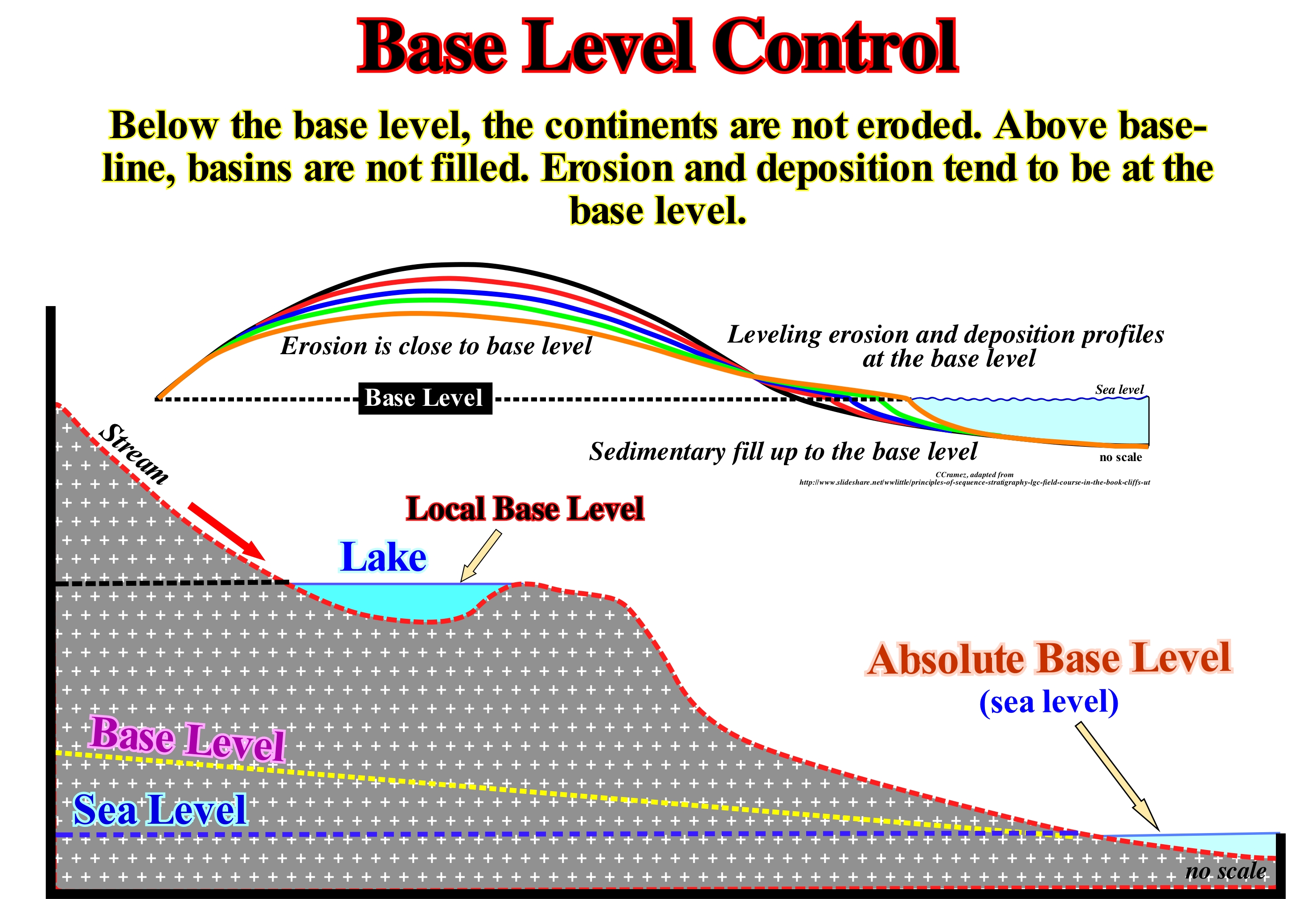
The base level of a current is the lowest point of the current beyond which the current can no longer erode. In other words, when a current reaches its base level, its kinetic energy* is, practically, zero. As illustrated in this figure the base level of a current may be represented by: (i) A lake, in which case the base level is temporary or (ii) The sea (in this case, the base level is definitive). The base level is, more or less, associated with the longitudinal profile of the water-course. When the current is young, the profile corresponds to a concave line upwards which represents, more or less, the irregularities of the current bed, which means that the profile of the current is not in equilibrium once the current is, continuously, eroding. When the current reaches a maturation stage, its longitudinal profile is,, relatively abrupt in the upper sector of the current. In the middle sector, it is a curved and concave upward and ends near the mouth by being horizontalized. Theoretically, since a current reaches its longitudinal equilibrium profile the current does not erode any more, which many geoscientists consider an utopia. For them, an equilibrium profile is always provisional. Without much error, it can be said, in general, the base level of a current is, more or less, the sea level. In reality, it is, usually, a little lower due to the action of waves and coastal currents. The continuation of the base level continentward defines the final level of denudation**. However, it should not be forgotten that the base level of a current changes with the position of the relative sea level (the result of the combination of absolute or eustatic sea level, supposed global and referenced to the Earth's centre and tectonics). Within a sequence-cycle, during the transgressive episodes, following marine ingressions, the base level, globally, goes up which gives more available space for the sediments (accommodation). When the relative sea level (local sea level referenced to any point on the Earth's surface, which can the sea-floor bed or the base of the sediments), falls the opposite occurs: the base level of the currents comes down. Such a falling increases the area subject to erosion, what causes a considerable growth in the terrigeneous influx, once the previously deposited clasts (sediments) are reworked. On the continent, the processes of aggradation and incising currents are regulated, obviously, by their provisional equilibrium profiles. As said before, the equilibrium profile of a river is never definitive, since the river continues to deepen (there is erosion upstream, once materials are supplied to the current). As, over time, the entire basin is eroded, the river load (amount of material transported) becomes weaker. One can imagine an ideal moment in which all the transport disappears and the inclination of the current is, just, enough to guarantee its flow. Under such ideal conditions, the current would reach its ideal or definitive equilibrium profile. As illustrated in the upper diagram, the concept of base-line level can be generalized as the equilibrium surface between erosion and sedimentation. Below the base level, the continents are not eroded. Above the base-line, basins are not filled. Erosion and deposition tend to be at the base level. In this way, the concept of equilibrium profile is part of the concept of base level. It may be said the base level of a stream is the lowest point at which it can still flow and that, in most cases, it corresponds to its mouth (not to P. Vail for who the base level of a current is the bayline). For major rivers, sea level is the base level, just as a river or lake is the base level of a tributary stream. Certain lakes, located at more than 2,000 meters of altitude are the base level of much of the drainage of the Swiss Alps. When a river is dammed, a new base level forms upstream of dam (the base level of the river rises, which slows down the stream and favours deposition). When deposition behind a dam reaches its maximum (deposition ceased), the gradient of the deposition surface (slope) is half that of the initial channel or bed (before the river is dammed). Do not confuse base level with "water table", which is the upper level of the saturated part of the groundwater, which is at atmospheric pressure.
(*) The energy (quantitative property that must be transferred to an object in order to perform work on) that it possesses due to its motion and that is defined as the work needed to accelerate a body of a given mass from rest to its stated velocity. The work measure of energy transfer occurring when an object is moved over a distance by an external force at least part of which is applied in the direction of the displacement.
(**) In geology, denudation is the reduction of elevation and flattening of terrestrial relief forms by a set of geological processes that cause the surface wear of the Earth due to the movement of water, ice, wind and sea waves. Endogenous geological processes such as volcanoes, earthquakes and plate tectonics uplift and expose the continental crust to the exogenous processes of weathering, erosion, etc.
Base Outflow (Base stream flow)......................................................................................................................................................Débit de base
Escoamento de Base / Flujo de base / Baseflow, Dürre fließen, Rezession Grundwasserfluss / 基流 / Грунтовый сток / Flusso di siccità, Flusso di recessione delle acque sotterranee, Basso flusso, Flusso di acqua bassa, Flusso di base /
Ground-water that enters in a channelled stream of a river, for instance, allowing the current to remain, even when it does not rain.
See: « Flux »
&
« River »
&
« Water Table »
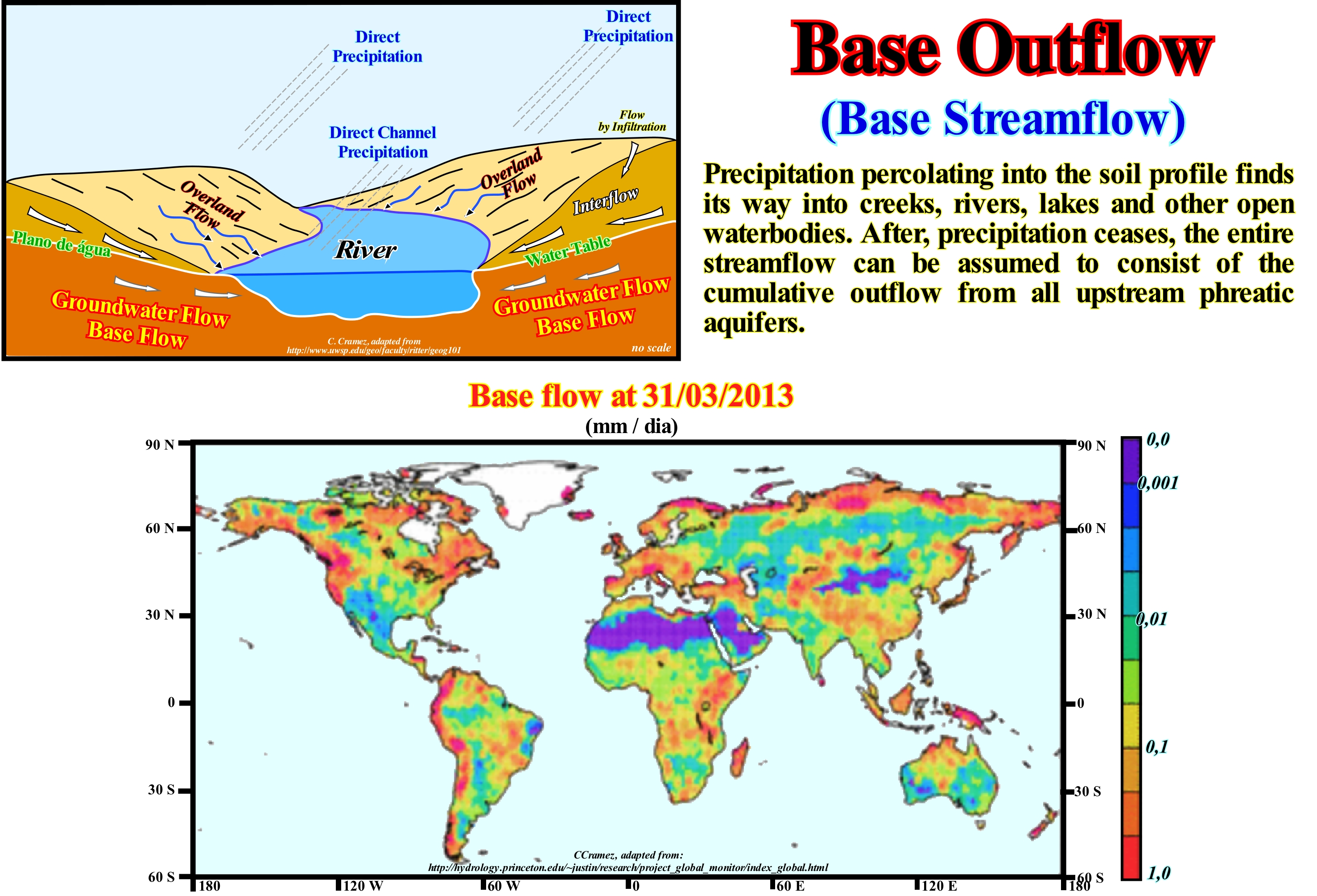
As shown in this diagram, in theory, there are four main sources responsible for feeding a water-course (a river, for instance): (i) Direct flow, that is to say, direct precipitations, such as rain or snow ; (ii) Infiltration flow, i.e., surface water infiltrating the soil ; (iii) Surface runoff or overland flow, i.e., water flowing over the surface of the land and (iv) Base flow or ground-water flow (certain geoscientists also call it normal flow), which is the ground-water that feeds the currents. For the currents, which are, more or less, permanent, the water plane is at the same level as the water-course, as illustrated in the geological sketch. The flow or base flow refers to the flow of water entering, directly, into the streams of the ground-water system, instead of flowing at the surface of the earth. As water flows more slowly through the ground than at surface, the ground-water is, progressively, fed from water courses, unlike surface water, in particular, after heavy rain. This means that during periods when rainfall is scarce, as in the summer, in the countries of the Northern Hemisphere, it is the base flow that feeds the rivers. When the ground-water feeds, totally, a current, we say that the hydrological conditions are of base flow. Ground-water enters the water-course when the water-plane (upper limit of saturation of ground-water) rises above the base of the stream (river bed). The water-plane is the level at which the ground-water pressure equals atmospheric pressure. This plane, generally, coincides with the piezometric surface of the water table* (upper surface of the water in a saturated area), but may be above. An amount of sustainable water in a sedimentation interval below the water level, i.e., in the phreatic zone (saturation zone, in which the pores and fractures of the rocks are saturated with water) is called an aquifer. The water table varies with the seasons and during periods of drought.
(*) The difference between the water table and the piezometric surface is the same as between the natural surface of the ground-water and the surface of a monitoring well in a confined aquifer. The two measurements are used to estimate the discharge and refill flows needed to describe the quantity and quality of the water reservoirs. Due to the capillary nature of the water, the piezometric surface (the surface representing the water pressures in the upper part of the confined aquifer) may be above the water table (under which the ground-water fills all the porous and permeable spaces of the soil), but the pores of the soil contain a lot of air.
Baselap.....................................................................................................................................................................................................................................Bisel de base
Bisel da base / Bisel de base / Baselap, Bevel der Basis / 锥的基 / Прилегание / Bisello della base /
Termination of a stratum or seismic reflector, against the lower boundary of a stratigraphic cycle as, for instance, against the lower boundary of a sequence-cycle (stratigraphic cycle induced by a 3rd order eustatic cycle, whose time-duration varies between 0.5 and 3-5 My). Two types of baselaps can be recognized in the field and seismic lines: (i) Onlap and (ii) Downlap.
See: « Onlap »
&
« Downlap »
&
« Aggradation »
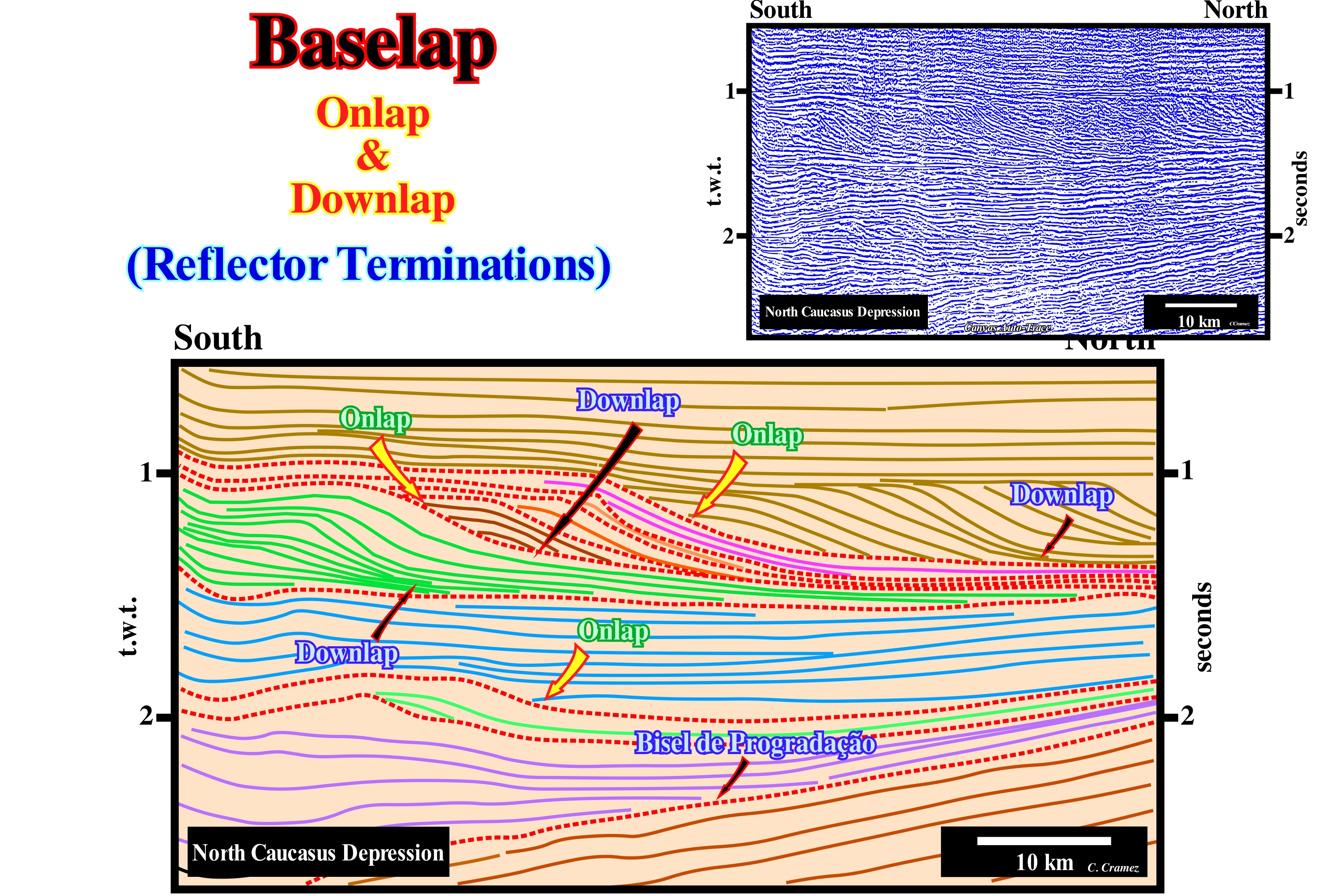
The North Caucasus onshore corresponds to a fold mountain belt in the classification of the sedimentary basins of Bally and Snelson (1980). It resulted from the collision of two Atlantic-type divergent margins and the underlying Mesozoic/Cenozoic rift-type basins created by the break-up of the supercontinent Pangea. The baselaps are, easily, recognized in this tentative geological interpretation of a Canvas auto-trace of a seismic line of this onshore. They underscore the unconformities (erosional surfaces, induced by significant relative sea level falls, which put the sea level lower than the basin edge*), which separate the different stratigraphic cycles (in this case, the majority of them are, probably, sequence-cycle). The boundaries between the major stratigraphic cycles are underlined by red dashed lines, which translate into important hiatus, i.e., unconformities (an unconformity underlines, always, a more important gaps than the hiatus emphasized by its correlative paraconformity in deep-water). These unconformities, which limit the stratigraphic cycles, are fossilized by onlaps and downlaps, which underline relative sea level rises, i.e., marine ingressions, once to have deposition, the available space for sediments (accommodation) must increase (except for turbidite depositional systems). On geological interpretations of seismic lines, the term baselap is used just when the geoscientist in charge of the interpretation has not been able to decide whether the reflection termination of a seismic reflector corresponds to an onlap or a downlap. In certain cases, when the geometry of the reflectors is, more or less, parallel, as in an aggradational filling of a depression and the chronostratigraphic lines terminate by onlaps or by false downlaps**, they can be differentiated in proximal onlaps (where the onlapping is made in the sense of the source of the terrigeneous influx) and in distal onlaps (when the onlapping is done in the opposite sense to the origin of the terrigeneous influx). When the geometry of the chronostratigraphic lines is, sufficiently, progradational, the reflectors terminate by onlapping upstream (continentward) and by downlapping (seaward). This implies, necessarily, a zone of maximum deposition (maximum thickness) between them. This is the case for most sequence-paracycles, which have a spindle-shape geometry. A sequence-paracycle is deposited between two marine ingressions, i.e., between two consecutive relative sea level rises without any relative sea-level fall occurring between them. Between two marine ingressions, which move the shoreline continentward, increasing, significantly, the space available for sediments (accommodation), there is a stability period of the relative sea level, during which deposition occurs. The shoreline is displaced seaward (progradation) due to the deposition of the sediments building out a sedimentary regression. They are sequence-paracycles, bounded by flooding surfaces, which form the different sub-groups of sedimentary systems tracts that constitute a sequence-cycle. On this tentative interpretation, the collision between the two divergent margins is emphasized by the change in vergence of the progradations, which occurs, roughly, at 1.5 seconds (t.w.t) depth. The term "collision" used here, can be deceptive, since in plate tectonics the kinetic energy plays no important role, i.e., there is no transformation of kinetic energy into "deformation" energy***, such as when a car strikes a wall.
(*)The term basin refers here to the area of a stratigraphic cycle, whether it is a sequence-cycle or a continental encroachment cycle, that is under a major water-depth. Thus, when, within a sequence-cycle, the basin is said to have no shelf, this means that the sea level is lower than the basin edge (during the deposit of the lowstand systems tracts group). On the contrary, when it is said that the basin has a shelf, this means that the sea level is higher than the basin edge (during the transgressive interval and the 1rst stage of the highstand prograding wedge). Here we can say sea level, since we are not talking about any change (rise or fall). However, when one speaks of a sea level change, one always needs to know whether it is a change of the relative or absolute sea level.
(**) A false downlap is a downstream tangential termination of a reflector. The reflector becomes, more or less, horizontal and continue outward as an independent stratigraphic units that is, often, so thin that it is not visible on seismic lines.
(***) in fact, there are just three types of energy, the kinetic energy, i.e., the ability to do work through the movement and the potential energy, i.e., the ability to do work through the position and the energy of electromagnetic radiation, such as the energy of light, such as the one transported from the Sun to Earth and which heats us or aliments photosynthesis. Although we often meet terms such as electrical energy, chemical energy, nuclear energy, deformation energy such things do not really exist. They are just practical abbreviations for specific combinations of the kinetic energy and potential energy. The electrical energy, for instance, is only the potential energy of negative charge electrons in the presence of positive charges.
Baseform (Baselap)..................................................................................................................Relation géométrique (De base ou de la base)
Relação Geométrica (de base e da base) / Relación geométrica (de base o de la base) / Geometrischen Beziehung (Basis-oder Grund) /几何关系(基地)/ Геометрическое соотношение (базовое) / Relazione geometrica (base o di base) /
One of the geometric relations describing strata or seismic reflection terminations along the lower boundary of a sequence-cycle*. The term baseform is, also, used to denominate structures at the base of a bed (marked ripples, dunes, etc.) created by the flow and associated with the movement of the sedimentary grains.
See : « Stratigraphic Cycle »
&
« Stratal Patterns »
&
« Sequential Stratigraphy »
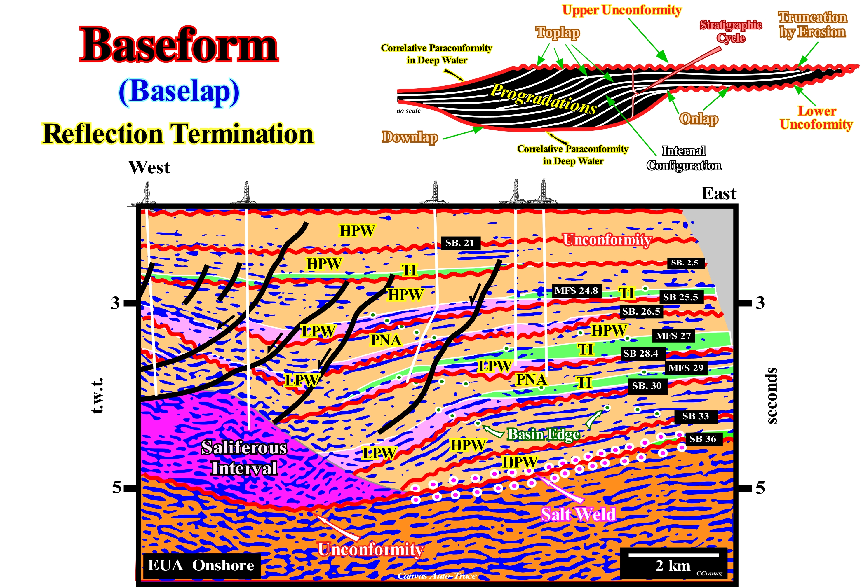
Without entering into semantic discussions about the meaning of the term "Baseform" used by EPR (Exploration Production Research of Exxon) at the beginning of Sequential Stratigraphy (late 1970s), what is fundamental is that the identification and mapping of the geometric relationships and terminations of the reflectors (on the seismic lines) or on strata (in the field), allows to advance several conjectures about the geology and stratigraphic of the sedimentary basins. The basal geometric relationships ("baselaps"), i.e., onlap (geometric relation between strata or initially horizontal seismic reflectors, which terminate against an inclined surface) and downlap (geometric relation associated with the lower limit of a stratigraphic cycle in which strata, or originally inclined seismic reflectors terminate, downstream on an originally horizontal or less inclined strata), should not be confused with the relationships found, sometimes, at the base of the of sedimentary beds (bedforms). In this tentative geological interpretation of a Canvas auto-trace of a detail of an onshore seismic line of the United States (Texas), made at the hierarchical level of the stratigraphic cycles called sequence-cycles (basic stratigraphic intervals deposited during 3rd order eustatic cycles whose time-duration varies between 0.5 My and 3-5 My), among other things, it can be said that: (i) Between 2 seconds (double time or t.w.t.) and the base of the evaporite interval (emphasized in violet and represented, locally, by an associated salt weld underlined by white circles), the erosional surfaces induced by significant falls of the relative sea level (local sea level referenced to any fixed point on the land surface, whether, for instance, the base sediments or the sea-floor and which is the result of the combined action of the tectonics and the absolute or eustatic sea level, supposed to be global and referenced to the Earth's centre) that put the sea level lower than the basin edge, allow us to identify the unconformities limiting the considered sequence-cycles ; (ii) Some of these sequence-cycles are incomplete and are represented just by highstand systems tracts group (transgressive interval, TI and highstand prograding wedge HPW) ; (iii) The other sequence-cycles have a well developed lowstand prograding wedge, but the submarine basin floor fans (SBFF) and the submarine slope fans (SSF) are, almost always, absent ; (iv) The basin edge, which coincides with the continental edge, when the basin has a shelf (except during the 2nd stage of development of the highstand prograding wedge), moved seaward, i.e., globally, westward ; (v) It is only during transgressive interval (TI) and during the 1sd stage of development of the highstand prograding wedge (when the basin still has a platform) that the shoreline moves eastward, that is, continentward ; (vi) Halokinese (salt tectonics, σ1 vertical and σ2 = σ3, without tectonic vector σt=0) created at the base of the saliferous interval a tectonic disharmony that can coincide, locally, with an unconformity ; (vii) Above the tectonic disharmony, which coincides, often, with a salt weld (when all the salt was, laterally, evacuated, the sediments, salt included, are, significantly, lengthened, which is not the case with the sediments underlying the salt interval ; (viii) Just the lowstand sedimentary systems tracts subgroups, highstand prograding wedge (LPW) and transgressive interval (TI), deposited in association with eustatic paracycles** (a rise and stabilization of the relative sea level, with no significant relative sea level fall), could be brought to light (rarely a single sedimentary systems is deposited during an eustatic paracycle or, in other words, a sequence-paracycle is, rarely, composed of a single sedimentary systems tract, especially on the seismic data).
(*) A sequence-cycle is a stratigraphic cycle induced by a 3rd order eustatic cycle, whose duration varies between 0.5 and 3-5 My.
(**) Eustatic paracycles are probably induced by the Milankovitch orbital cycles, which control the solar energy received by the Earth's surface. Climatic variations induce changes in the amount of water in the ocean basins. Milankovitch's orbital cycles have durations of 19 k, 23 k, 41 k, and 100 k years) or in other words, rarely a sequence-paracycle is composed of a single sedimentary systems tract).
Basin (Carbonate facies belt)..................................................................................................................................................Bassin (Ceinture carbonatée)
Basin (cintura carbonatada) / Cuenca (de faja carbonática) / Becken (Carbonat Gürtel) / 盆地(碳酸盐腰带) / Бассейн / Bacino (carbonato di cintura) /
Distal sedimentary environment of a carbonated facies belt characterized by: (i) A geological context ; (ii) A particular type of sediment and (iii) A particular biota. Seaward, the sedimentary environments of a carbonated facies belt are: (i) Basin ; (ii) Open Sea Shelf ; (iii) Deep Shelf Margin ; (iv) Foreslope ; (v) Organic Build Up ; (vi) Winnowed Edge Sands ; (vii) Shelf Lagoon Open Circulation ; (vii) Restricted Circulation Shelf and Tidal Flats and (ix) Evaporites on Sabkhas Salinas.
See: « Carbonate Facies Belt »
&
« Basin (sedimentary) »
&
« Mega-suture »
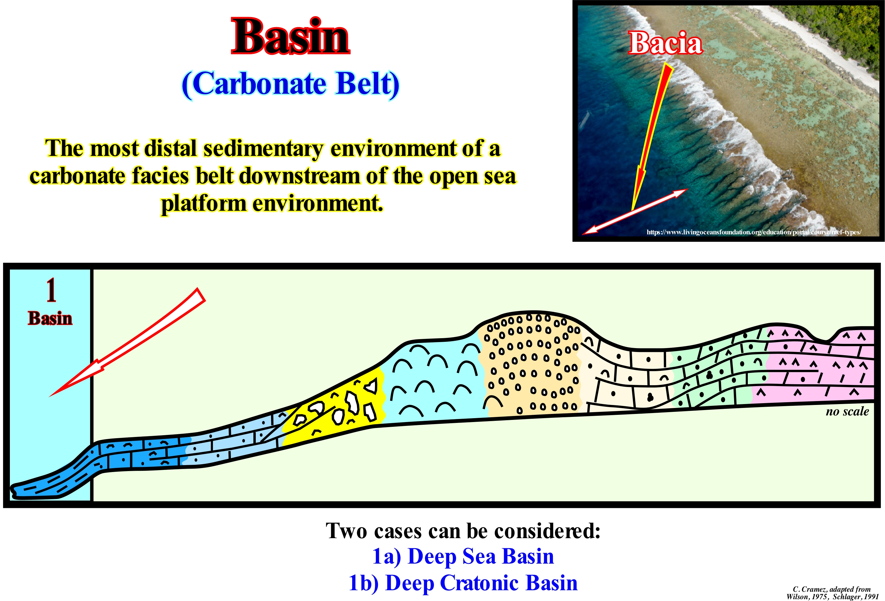
In a carbonated facies belt, as shown in this figure, two types of "basins" are frequent: (i) Deep Sea Basin and (ii) Deep Cratonic Basin. Both types are characterized by different geological contexts, sediments and biota. The Deep Sea Basin is characterized by: (a) A geological context, located under the action of the sea-waves and under the euphotic or photic zone (the zone in which sunlight penetrates, whose depth of which is very variable and dependent on the turbidity of the water) and a part of the deep-sea, being able to surpass the thermocline (a relatively thin layer of water within which the temperature changes very rapidly, with depth) ; b) Sediments, belonging to the whole set of deep sediments such as pelagic argillites, carbonated and siliceous oozes, hemipelagic mud and turbidites ; c) Biota characterized by plant and animal complex set of the geological time and area, which includes oceanic associations of plankton and, near the platform, shallow-water benthos. The Deep Cratonic Basin is characterized by: 1) A geological context, characterized by a location under the action of the sea waves and below the euphotic zone but, usually, not related to deep ocean water ; 2) Sediments similar to those of the Deep Sea Basin (however, the Mesozoic/Cenozoic basins have, rarely, pelagic argillites ; however, hemipelagic muds deposited between 200 and 1000 meters of water-depth are common and may have anyhdrite and flint ; on the other hand, anoxic conditions are commons and sediments are rich in organic matter ; 3) Biota, which is predominantly nekton (marine, pelagic, active, free-swimming, and migratory) and plankton (aquatic animals, mostly microscopic, which float and are drawn by marine currents), as well as, bivalve lumachels and sponge spurs. It can be said the main microfacies of this sedimentary environment are: (i) Microbioclasts (small material derived from structures that support or protect animals or plants) ; (ii) Espiculitis (sedimentary rock or sediment composed of sponge spicules) ; (iii) Calcissiltites, which according to the granulometry can have different names: a) Calcirudites, grains larger than 2mm ; b) Calcarenites, grains between 2 and 0.062 mm ; c) Calcissiltites, grains between 0.062 and 0.0039 mm and d) Calcilutites, grains less than 0.0039 mm ; (iv) Pelagic micrite, i.e., a very thin, crystallized pelagic carbonate mud (with calcite crystals less than 4 μm), which contains, sometimes, micro-detritus of organisms, clay particles, oxides and hydroxides, sulfates and sulphides and (v) Radiolaritic clay minerals, that is, argillites containing radiolarites (amebioid protozoa that give rise to intricate mineral skeletons, usually with a central capsule dividing the cell into inner and outer portions (endoplasma and exoplasm, respectively). On seismic lines , taking into account the vertical scale and the seismic resolution **, the differentiation and even the identification of these types of carbonate facies belt is difficult to do. When seismic lines are of good quality and are calibrated by a exploration wells, which have recognized a carbonate facies belt, the environments will, probably, be recognized after two or three tentative geological interpretation. There are different types of carbonated platforms: (A) Rimmed carbonate platforms, with reefs or reefal shoals on the edge of the platform ; (B) Ramp type platforms, with carbonated sands, but without major reefs at the coastline, and clay sands and deep water mud, at the base of the ramp ; (C) Epireic platforms with tidal surfaces and protected lagoons ; (D) Isolated platforms, with reefs and sands, on the windward margin (facing the direction from which the wind is coming) and muddy sediments, on the leeward side (the side sheltered from the wind) ; (E) Drowned or dead platforms (when they are under the photic zone).
(*) The term basin used above has nothing to do with the term basin used in the classification of the sedimentary basins of Bally and Snelson. It emphasizes, here, a sedimentary environment of the carbonated facies belt deeper than the others and with a characteristic facies.
(**) Vertical seismic resolution is, roughly, the size an object must to have to be seen on a seismic line. Stratigraphic intervals with a thickness equal to 1/4 of the wavelength of the seismic waves can be recognized. The horizontal seismic resolution is derived from the Fresnel zone, since the seismic waves move in three dimensions and propagate over an increasing area as they move away from the source. In a horizon, more or less deep, all objects with a lateral extension superior to the Fresnel zone will be visible.
Basin (Sedimentary)...........................................................................................................................................................................Bassin sédimentaire
Bacia sedimentar/ Cuenca sedimentaria / Sedimentbecken / 沉积盆地 / Осадочный бассейн / Bacino sedimentario /
Low land area of the Earth's crust, with a variable geometry, with a form almost circular to linear, usually of tectonic origin and in which sediments can be deposited, but thicken, always, toward the deepest and central part (the most subsident). A sedimentary basin is an extensional geological structure with a sinform geometry (a syncline is a compressional structure), more or less circular, in which the layers dive and thicken, slightly, to the centre.
See: « Megasuture »
&
« A-type Subduction (Ampferer) »
&
« B-type Subduction (Benioff) »
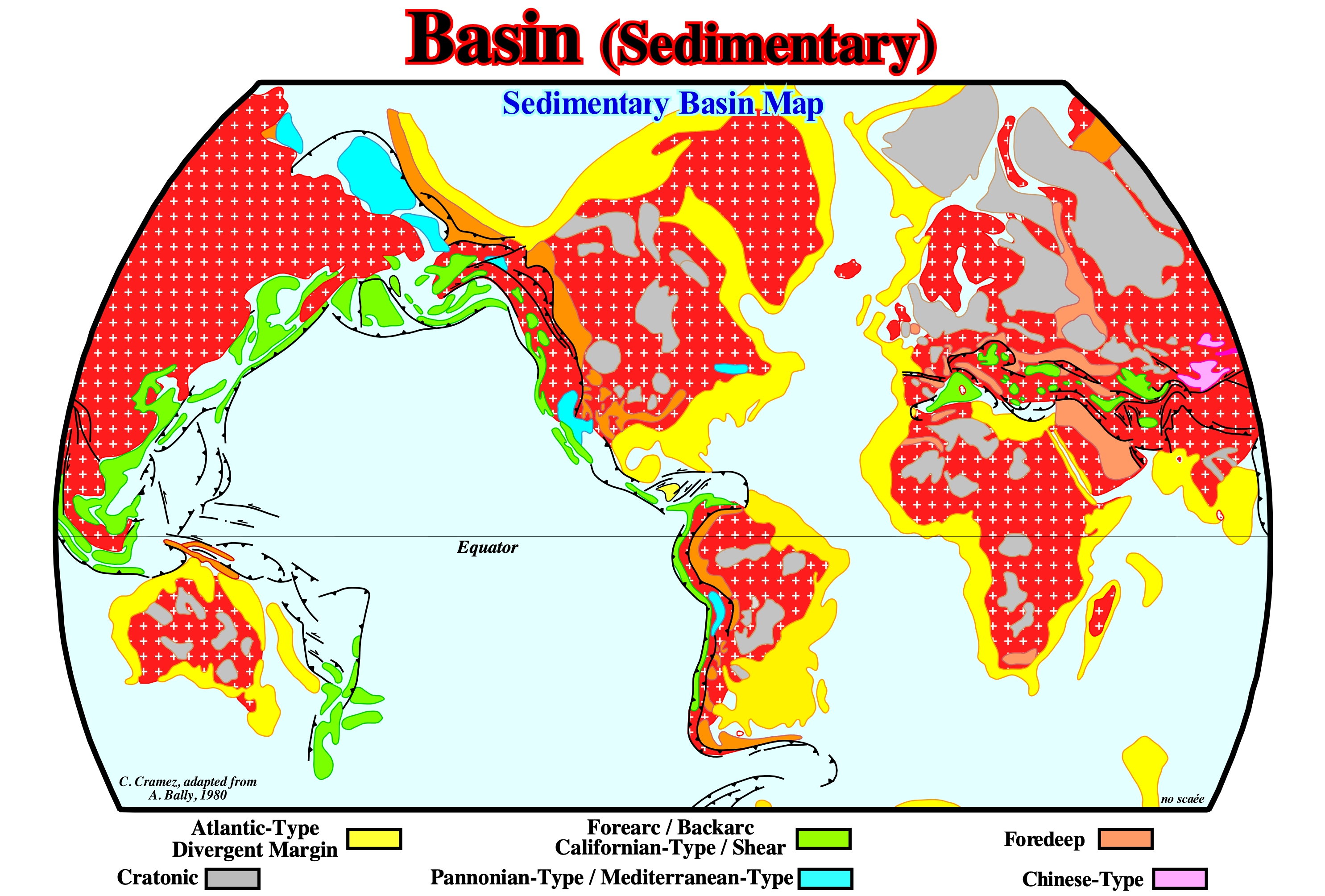
In sequential stratigraphy, the term basin refers, always, to the morphology of a stratigraphic cycle, whether it is a continental encroachment cycle or a sequence-cycle. At the hierarchical level of a sequence-cycle, geoscientists say the basin has no shelf during the deposition of the lowstand systems tracts group: (i) Submarine basin floor fan (SBFF) ; (ii) submarine slope fan (SSF) and (iii)lowstand prograding wedge (LPW), The same happens, during the deposition of the second stage of development of the highstand prograding wedge (LPW). On the contrary, the basin has a shelf (continental platform, during the deposition of the transgressive interval (TI) and during the first stage of development of the highstand prograding wedge (LPW), which are the sub-groups of the highstand systems tracts group (HSTG). The geographical names of the basins, such as Lusitanian Basin, Paris Basin, Neuquen Basin, etc., are to be avoided. They area geographic basins that correspond, often, to the temporal and spatial stacking of different types of sedimentary basins of the classification of Bally and Snelson (1980) that we adopt in this glossary. This map illustrates the distribution of the different types of Mesozoic/ Cenozoic sedimentary basins* considered in the classification of Bally and Snelson (1980), which is mainly based on subsidence. These geoscientists recognize two major types of sedimentary basins: (i) Basins not associated with the formation of Mesozoic/Cenozoic megasuture** and (ii) Basins associated with the formation of Mesozoic/Cenozoic megasuture. In the former, there are three main classes: (a) Cratonic basins, which developed on the Paleozoic continental crust, and which were, generally, created by a regional thermal subsidence ; (b) Rift-type basins, which were, generally, created on the Paleozoic continental crust of the by a differential subsidence, when the lithosphere was, locally, lengthened and (c) Divergent Atlantic-type margins, developed over the rift-type basins, in association with a thermal subsidence, since the break-up of the lithosphere of the supercontinent Pangea. As rift-type basins are, usually, covered by either a cratonic basin or by a divergent margin, they are not visible in the map illustrated in this figure. In the sedimentary basins associated with the Mesozoic/Cenozoic megasuture formation there are two large families: (1) Perisutural basins, which developed at the periphery of the megasuture, in association with a B-type (Benioff) or A-type (Ampferer), such as fore-deep basin (foreland basins) and fore-arc basin (external to the volcanic arch), and (2) episutural basins, which have developed within the megasuture, such as back-arc basins, Mediterranean-Type basins and Pannonian-type basins. The lengthening behind the volcanic arc can be very important and create an oceanization, i.e., a breakup of the lithosphere with formation of a marginal sea (formation of new oceanic crust), in which divergent non-Atlantic margins develop. The fundamental difference between Atlantic-type and non-Atlantic-type divergent margins is that the former develop in a tectonic context, globally, compressional (sedimentary shortening), i.e.,, they are located within the megasuture, while the latter are formed in an extensional context (sedimentary lengthening), outside of the megasuture. This classification can, of course, be used for the Paleozoic basins. For that, just substitute the supercontinent Pangea by the supercontinent Proto-Pangea (Rodhinia) and the Mesozoic/Cenozoic megasuture by the Paleozoic megasuture. Taking into account the geological time, a given area may correspond to the stacking of different sedimentary basins. Thus, for example, the Angola offshore, from bottom to top, corresponds to the stacking of: (i) A more or less flattened Paleozoic mountain folded belt or a Precambrian basement ; (ii) Late Jurassic / Early Cretaceous rift-type basins and (iii) A divergent Atlantic-type margin deposited since the Early Cretaceous until today, in which two tectonic-sedimentary phases can be evidenced: a) A Regressive phase with a well-marked progradational geometry and b) A Transgressive phase with a characteristic retrogradtional geometry. Taking into account the geometry of these phases, it a major downlap surface exist between them is evident. This classification, like all other classifications of the sedimentary basins, does not predict the volume of hydrocarbons generated and preserved in the different sedimentary basin families. However, it allows and, to a certain extent, it obliges the geoscientists in charge of petroleum exploration to make geological observations based and controlled by the plate tectonics theory, which is the basis of all progress in the geology and success of oil exploration. It allows, in particular, a better evaluation of the different petroleum parameters (1) Source-rock ; 2) Reservoir-rock ; 3) Trapping ; 4) Migration and 5) Retention, which form the potential petroleum systems and quickly highlight the key parameter, which can "kill" a basin or a petroleum prospect*** at the petroleum exploration point of view.
(*) In this classification, only sedimentary basins over 1000 meters thick are taken into account. The abyssal plains of the oceans, certain marginal seas, volcanic plateaus, etc., are excluded.
(**) A megasuture is a mobile region of the Earth (folded and faulted mountain ranges) that testifies to the complexity of the accretion and deformation phases undergone by the geological bodies in the regions where the compressive tectonic regimens are predominant. The term megasuture was first used by A. Bally (1975). Although the compressive tectonic regimes (shortening) associated with the subduction zones are predominant in the formation of a megasuture, extensive regimes (lengthening) and the formation of sedimentary basins also play an important role.
(***) An area of exploration in which hydrocarbons have been predicted to exist in economic quantity. A prospect is often an anomaly, such as a geological structure or a seismic amplitude anomaly, that is recommended by explorationists for drilling a well. Justification for drilling a prospect is made by assembling evidence for an active petroleum system, or reasonable probability of encountering reservoir-rock, a trap of sufficient size, adequate sealing rock, and appropriate conditions for generation and migration of hydrocarbons to fill the trap. A single drilling location is also called a prospect, but the term is more properly used in the context of exploration. A group of prospects of a similar nature constitutes a play. (https://www.glossary.oilfield.slb.com/en/Terms/p/prospect.aspx)
Basin Downlap...............................................................................................................................Biseau de progradation de bassin
Bisel de Progradação de Bacia / Bisel de progradación de cuenca / Basin downlap, Bevel Basin Progradation, Progradierender Keil Becken / Progradational楔盆, 盆地downlap / Подошвенное прилегание в залежи / Bisello di progradazione di bacino, bacino downlap /
Downlap located dseawrd of the basin edge and particularly beyond the base of the continental slope. Within a sequence-cycle, this type of downlap is found, mainly, in lowstand systems tracts and in the 2nd stage of the highstand prograding wedge (HPW), once the basin has no longer a shelf (the depositional coastal break coincides, roughly, the continental edge).
See: « Downlap surface »
&
« Downlap »
&
« Depositionapl Coastal Break »
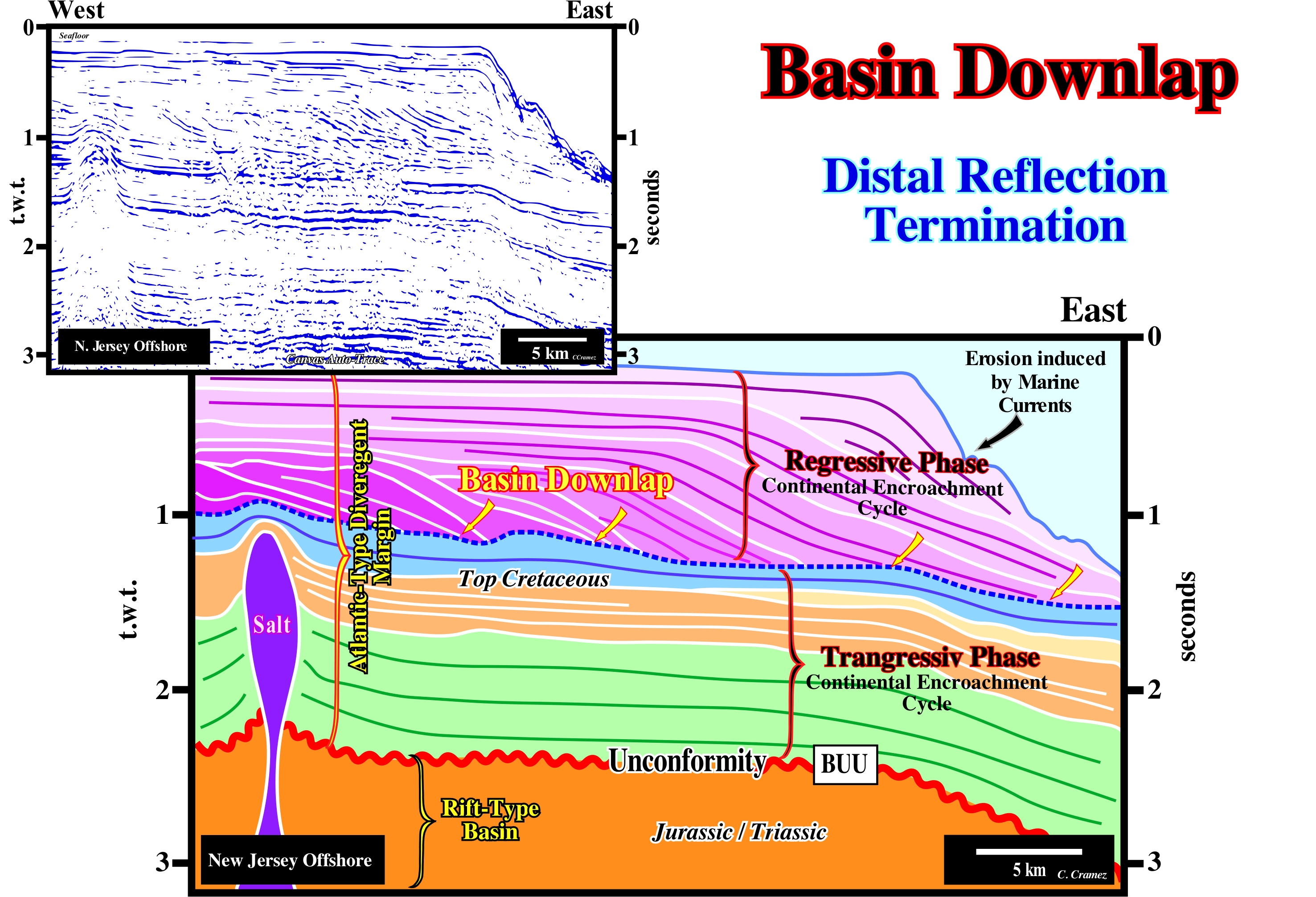
The New Jersey offshore (Baltimore canyon) corresponds to the stacking of several basins of the classification of the sedimentary basins of Bally and Snelson (1980). On regional seismic lines, from bottom to top, one can recognize: (i) A Precambrian basement or, sometimes, a folded and faulted Paleozoic mountains range, more or less, flattened ; (ii) Triassic-Jurassic rift-type basins and (iii) A divergent Atlantic-type margin. The rift-type basins are formed during the lengthening of the supercontinent Pangea. They are separated from the Mesozoic/Cenozoic divergent margin by the break-up unconformity of the lithosphere (BUU). Within the post-Pangea continental encroachment stratigraphic cycle, induced by the upper first order Paleozoic eustatic cycle, two sedimentary phases can be highlighted. The first phase has a, globally, retrogradational geometry and is, therefore, called transgressive phase. The upper phase, which has a, globally, progradational geometry, is called regressive phase. The first phase is associated with an absolute (eustatic) sea level rise, while the regressive phase is deposited during a complex fall of absolute sea level. The sedimentary intervals deposited during the transgressive phase thicken continentward, before onlapping against the craton (supercontinent Pangea). Those deposited during the regressive phase thicken seaward, ending by downlapping, in the deep part of the basin. On this tentative geological interpretation of a Canvas auto-trace of a detail of a seismic line of this offshore, basin downlaps (or marine downlaps) are, easily, recognized in Cenozoic stratigraphic intervals, i.e., in the intervals of regressive phase. In this region and, particularly, during Tertiary the sea level changes are, essentially, induced by eustasy (absolute or eustatic sea level changes). The subsidence during the Cenozoic (set of colored intervals in violet tones) was very small, which is why, regionally, landward of the basin edge, not only the seismic intervals have, practically, a constant thickness, but also the coastal plain is subhorizontal. This means, the continental edge coincides, roughly, with the shoreline and therefore it was, also, the basin edge (taking into account the resolution of the seismic data, for the most part, the basin had no shelf). In the upper continental slope, the marine currents (more or less, parallel to the coastline) form depressions, sometimes called channels, perpendicularly to the continental slope, which are, later, filled by a lateral terrigeneous influx. Nevertheless, the strong activity of the coastal currents, the marine downlaps indicate, clearly, a regional terrigeneous influx (sedimentary supply) coming from West. The geological context of this area is, easily, recognized on this tentative interpretation. The half-graben geometry of the rift-type basins, which are not visible on this tentative, is evident on longer parallel seismic lines. Above the unconformity associated with the break-up of the lithosphere (BUU), the divergent margin is obvious, as are, also, the two sedimentary phases that constitute it. In the post-Pangea continental encroachment stratigraphic cycle (the interval between BUU discordance and the sea-floor), the transgressive phase, which corresponds, more or less, to the Cretaceous and Paleogene sediments, is characterized by an aggradational geometry, while the regressive phase has a progradational geometry. The interface between these sedimentary phases corresponds to a major marine downlap surface. A salt diapir, probably, implanted along a mechanical discontinuity (the bordering fault of a rift-type basin) deformed (lengthened) the sediments of the transgressive phase, as well as, the intervals of the regressive phase. As in a depth-version of the original seismic line, the progradations of the regressive phase correspond to continental slopes (water-depth greater than 200 m) and not to delta slopes (water-depth, rarely, exceeds 60 meters), the downlaps are basin downlaps and not platform downlaps.
(*) The two Phanerozoic first order eustatic cycles are defined by the absolute ( eustatic) sea level, i.e., by the sea level referenced to the Earth’s centre and not by the relative sea level. The relative sea level is the result of the combined action of the absolute sea level and tectonics (subsidence or uplift of the sea-floor). First-order eustatic cycles whose time-duration ranges, more or less, between 250 My and 400 My are mainly induced by the volume changes of the ocean basins caused by sea-floor spreading and the elimination of old oceanic crust along B-type subduction zones (Benioff).
Basin Edge (Sequence cycle)..........................................................................................................................................................Rebord du bassin
Rebordo da bacia / Borde de la cuenca / Rand des Beckens / 陆架边缘 / Обрыв шельфа / Bordo del bacino /
In a sequence-cycle (high hierarchical level of stratigraphic cycles), it corresponds, more or less, to the outer limit of the coastal plain. Its position depends on the sea level geological conditions (highstand or lowstand). It is the seaward limit of the continental platform (shelf), when the basin has a platform (highstand). When the basin has no shelf (lowstand geological conditions), the basin edge is the last continental edge of the preceding sequence-cycle. During the 2nd stage of development of the highstand prograding wedge (HPW), as the basin has no shelf, the basin edge is last depositional coastal break of the depositional surface, which corresponds, roughly, to the continental edge.
See: « Continental Platform »
&
« Depositional Coastal Break »
&
« Continental Slope »
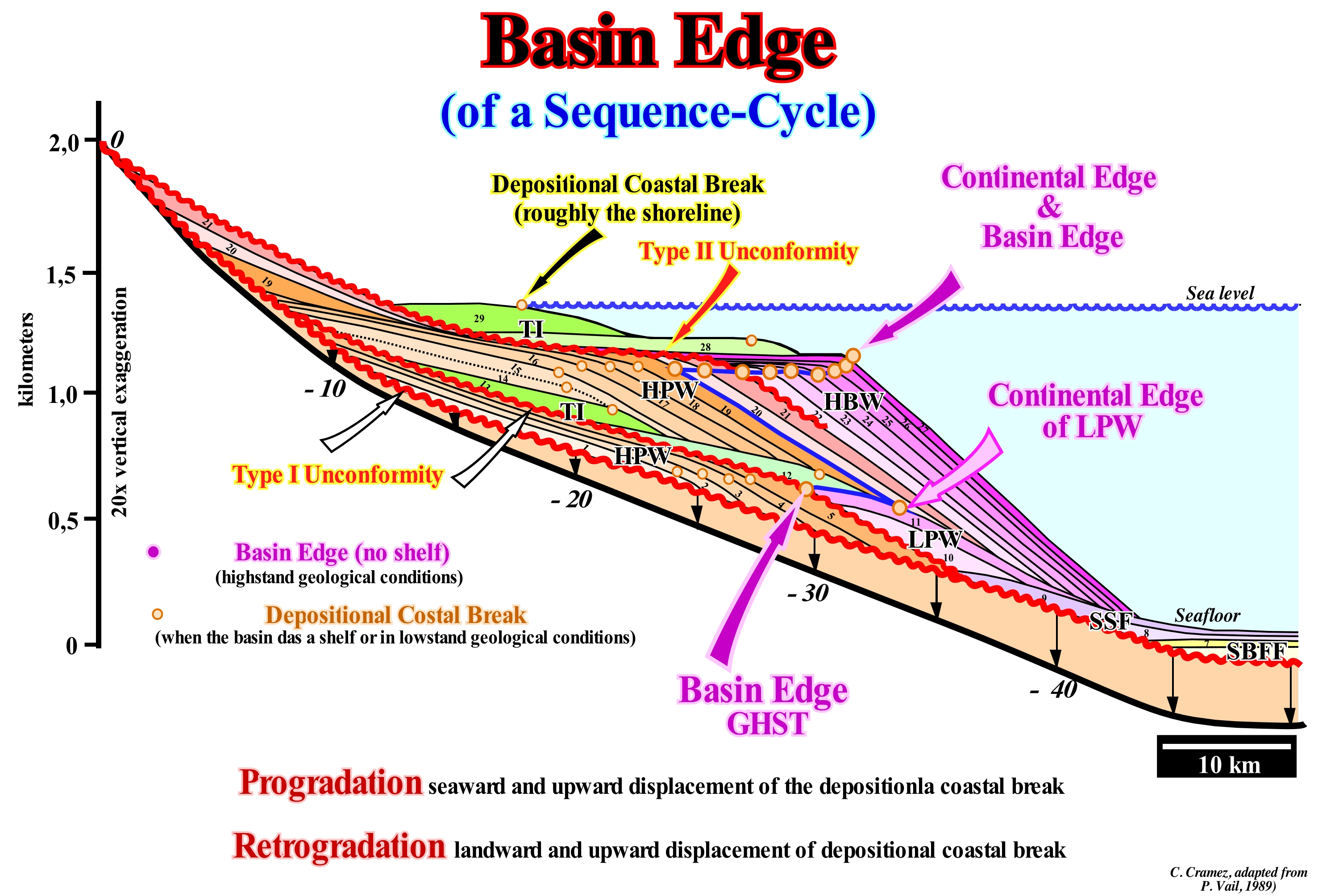
in a ramp geological basin settting, during the lowstand systems tracts of a sequence-cycle, speaking of the continental edge is meaningless, since there is a gradual passage between the shoreline and the deep environments. On the contrary, in a growth fault geological setting, the continental edge corresponds, more or less, to the position of the fault plane (intersection with the surface). In an abrupt morphological setting, during lowstand prograding wedge (LPW) or during bordering prograding wedge (BPW), as shown in this figure, the location of the continental edge is, relatively, easy. As can be seen in this sketch, during a sequence-cycle, the location of the basin edge is variable. The basin may or may not have a shelf. When the basin has a shelf (platform), the continental edge is the basin edge. When the basin does not have a shelf, the basin edge is the last continental edge of the preceding sequence-cycle. The continental edge is not the basin edge during the deposition of the lowstand systems tracts sub-groups, i.e., during the deposition of the submarine basin floor fans (SBFF), submarine slope fans (SSF) and the lowstand prograding wedge (LPW). During the deposition of these systems tracts sub-groups, the basin edge is the last basin edge of the preceding sequence-cycle. However, during the second stage of development of the highstand prograding wedge (HPW), when the basin ceases to have a shelf (the progradations of the highstand prograding wedge fossilize, completely, the shelf) the shoreline became, practically, coincident with the new continental edge, which continues to be the basin edge. In the sketch illustrated in this figure, during the highstand prograding wedge (1, 2, 3, 4 and 5) of the lower sequence-cycle, the basin edge is marked by successive continental breaks which coincide, roughly, with the shoreline, since the basin has no shelf (this sketch is, vertically, exaggerated, about 20 times). Since the relative sea level fall, the shoreline move seaward and downward exhuming the old coastal wedge and the upper part of the former continental slope, creating an unconformity (red). The relative sea level is the local sea level, referenced to any fixed point of the Earth's surface (base of the sediments or sea-floor) and it is the result of the combined action of tectonics and the absolute (eustatic) sea level, which is supposed to be global and referenced to the Earth's centre). The sea level became lower than the old basin edge (5) which remains the basin edge during the deposition of the lowstand systems tracts group (GHST) of the new sequence-cycle: a) Submarine basin floor fans (SBFF), 6 and 7 ; b) Submarine slope fans (SFF), 8 and 9 and lowstand prograding wedge (LPW), 10 and 11. Since the 1st flooding surface, the basin edge becomes the last continental edge of the lowstand prograding wedge (11), because the basin, due to flooding of the coastal plain of the lowstand prograding wedge, the basin get a shelf (continental platform). During the transgressive interval (TI), whose geometry is retrogradational, the basin edge continues to be (11), since the depositional coastal break (more or less the shoreline) moves continentward creating a shelf with a water-depth increasing progressively (12, 13, 14 and 15). When the relative sea level begins to rise in deceleration, the highstand prograding wedge (HPW) begins to deposit, decreasing, progressively, the size of the platform (16, 17, 18 and 19), as the depositional coastal break (shoreline) approaches the continental edge. As soon as the basin has no more shelf (19), the old basin edge is fossilized by slope deposits (2nd stage of development of the highstand prograding wedge). The shoreline is, more or less, coincident with the continental edge, i.e., the basin edges changes from (11) to (19). During the development of the highstand prograding wedge (HPW) and the bordering prograding wedge (BPW), the basin edge passes successively from 20 to 27, until a new the relative sea level rise, in acceleration, which precedes the deposition of the transgressive interval (TI).
Basin Fill..............................................................................................................................................................................................Remplissage de bassin
Preenchimento de Bacia / Relleno de cuenca / Beckenfüllung / 盆地填充 / Заполнение бассейна / Riempimento di bacino /
Sedimentary fill expressing how the basal unconformity of a stratigraphic cycle, usually, of continental encroachment cycle or sub-cycle, is fossilized by the overlying sediments. Sedimentary fill, which for scale reasons, is, generally, used to characterize the internal geometry of the stratigraphic cycles induced by 1st and 2nd order eustatic cycles.
See: « Basin (sedimentary) »
&
« Reflection Configuration »
&
« Relative Sea Level Change »
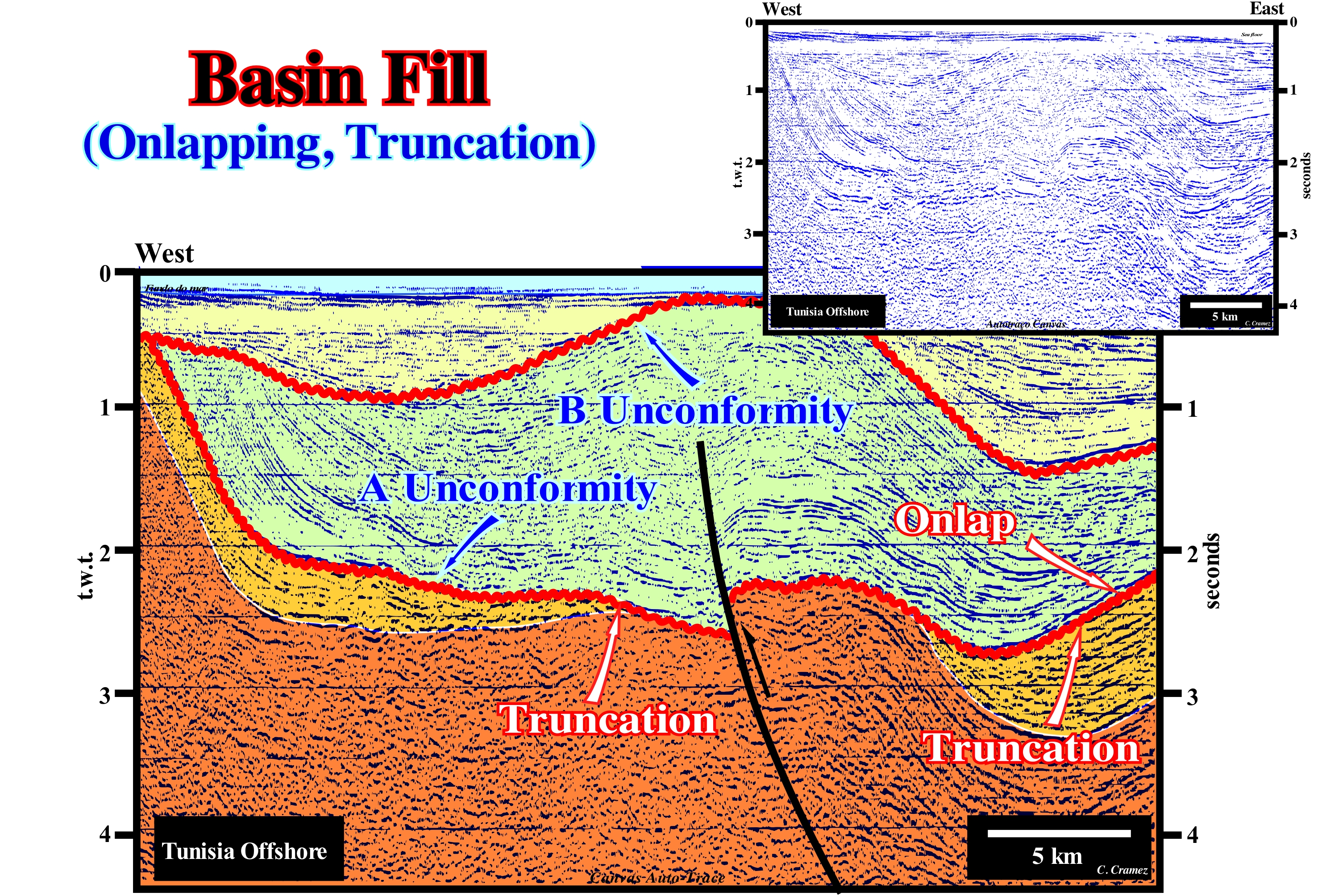
Taking into account the external geometric patterns, on this tentative geological interpretation of a Canvas auto-trace of a detail of a Tunisian offshore seismic line, a continental encroachment sub-cycle, induced by a 2nd order eustatic cycle (time-duration between 3-5 My and 50 My), limited by two unconformities (erosional surfaces induced by significant relative sea level falls), is easily recognized. As this continental encroachment sub-cycle was induced by a 2nd order eustatic cycle, the age difference between the two unconformities (unconformity A and B) is greater than 3-5 My and lesser than 50 My. The lower unconformity (unconformity A) marks, at a given geological time, the lower limit of a sedimentary basin fill. The reflector terminations underlying this unconformity are toplaps by truncation (especially on the east side of the auto-trace), and the overlapping terminations are onlaps which, were later deformed by tectonics. The upper unconformity (unconformity B), which marks the end of the basin filling, is defined by toplap by truncation (underlying sediments) and fossilized by onlaps of the recent sedimentary interval (colored in yellow). All this means that the two unconformities were tectonically enhanced. These unconformities correspond to what most geoscientists call, in a descriptive way, angular unconformities. A tectonic regime is either in compression (shortening), characterized by a horizontal σ1 (major axis of the ellipsoid of the effective stresses, that is to say, the sum of the geostatic pressure, σg, pore pressure or hydrostatic pressure, σp, and the tectonic vector, σt), whether it is in extension (σ1 vertical) it does not produce erosional surfaces. They are the relative sea level falls*, i.e., the falls of the local sea level referenced to the base of the sediments (top of the continental crust) or any other point on the land surface, such as the sea-floor, whose cyclicity is given by absolute (eustatic) sea level changes (global sea level, referenced to the Earth's centre) that exhume the sediments and place them under the action of erosive agents. A tectonic uplift, such as the upward movement of a salt dome (not exhuming the sediments) does not produces any erosional surface. The absolute (eustatic) sea level is dependent on: (i) Tectono-Eustasy, which is controlled by the volume variation of the ocean basins in association with oceanic expansion following the breakup of the supercontinents ; (ii) Glacio-Eustasy, which is controlled by the volume of water in the oceans as a function of the amount of ice (assuming that the amount of water, in all its forms, is constant since the Earth's formation, around 4.5 Ga) ; (iii) Geoidal-Eustasy, which is controlled by the distribution of ocean water caused by variations in the Earth's gravity field (where gravity is stronger than normal, sea level is thrown to the Earth's centre ) and (iv) Thermal expansion of the oceans or steric increase of sea level (if the temperature of the oceans increases, the density of the water decreases and, for a constant mass, the volume increases). At least three compressional tectonic regimes (shortenings) are evident on this tentative interpretation, which is not surprising, since the Tunisian offshore is within the Mesozoic/Cenozoic megasuture. The older tectonic regime precedes the lower unconformity (A) and the latter is posterior to the upper unconformity (B). The unconformity B, which was initially sub-horizontal, was shortened and uplifted creating an important tectonic inversion of basin filling. Among these regimes, there are extensional tectonic regimes during which most of the sediments were deposited. As an anecdote, it can be said before deforming the sediments it is necessary to deposit them. Obviously, the old normal faults, which contributed to the basin filling, played as a reverse fault shortening the sediments, during the late compressional tectonic regime.
(*) The relative sea level is the result of the combined action of absolute (eustatic sea level) and tectonics (subsidence of the sea-floor when sediments are elongated or uplift when the sediments are shortened. Although, in certain cases, the uplifted sediments, are lengthened and not shortened. This is particularly true, when they uplifted by salt or shaly diapirism.
Basin Floor Fan (Submarine)................................................................................................................Cône sous-marin de bassin
Cone Submarino de Bacia/ Cono submarino de cuenca / Beckenboden Fan, Cone U Boot - Becken / 锥海底盆地 / Донный конус выноса бассейна / Cono sottomarino di bacino /
Turbidite deposit, which within a sequence-cycle, is located in the deepest part of the basin. The stacking of submarine basin floor fans (SBFF) form the lower lowstand systems tracts sub-group. Submarine basin floor fans are, easily, recognized not only by their stratigraphic position, but by their subhorizontal geometry as well. In the electrical logs, submarine basin floor fans have, generally, a cylindrical morphology and abrupt limits.
See: « Turbidite »
&
« Relative Sea level Fall »
&
« Slope Fan (submarine) »
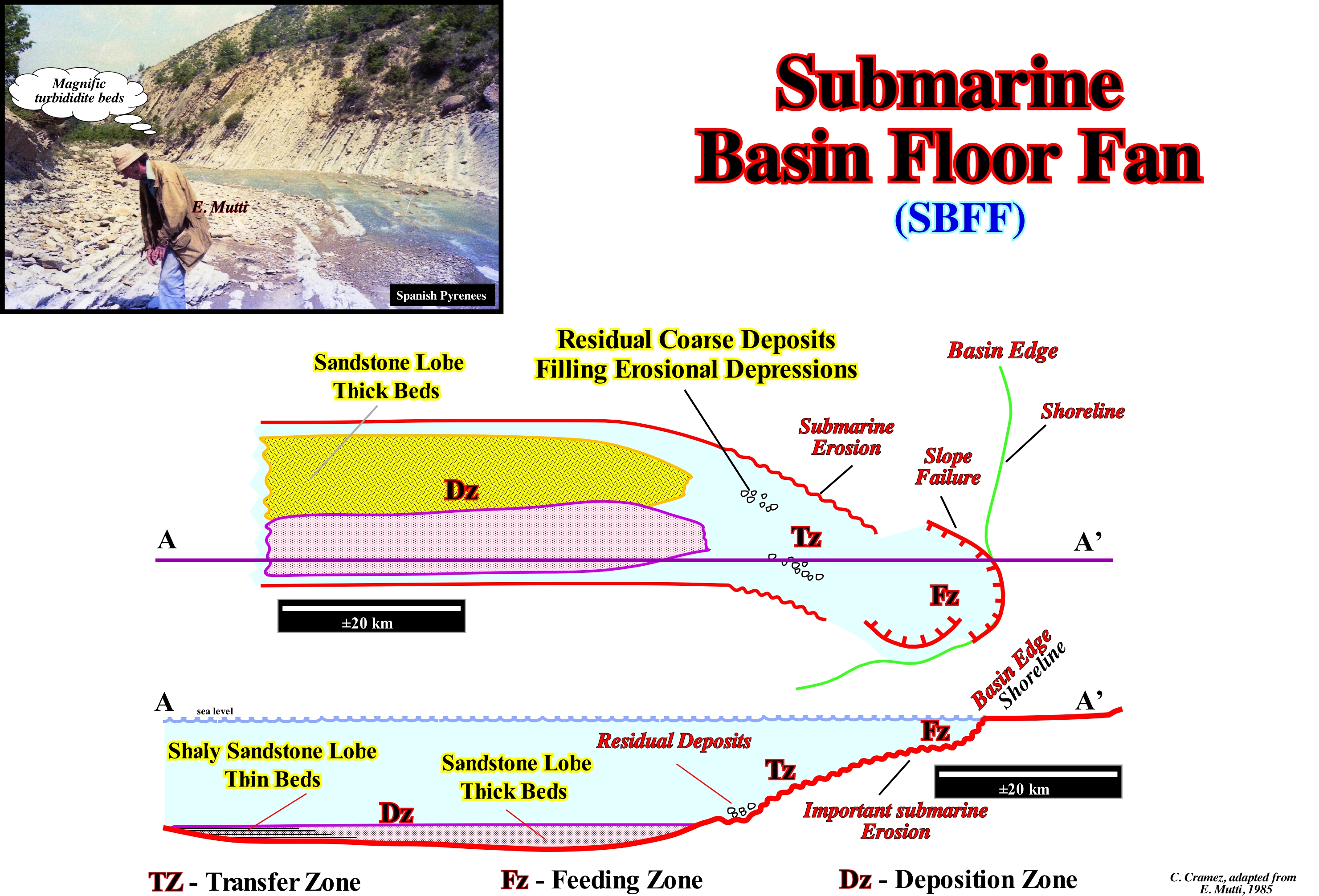
Emiliano Mutti (1985) proposed a geological model for certain submarine turbidite lobes somewhat different from the model proposed by P. Vail (1977). In the Mutti model, as shown in this figure, basin turbidite fans can be deposited during geological periods of highstand (when relative sea level* is above the basin edge) in association with failures, by sliding, produced at the top of the continental slope, but also during lowstand geological periods (sea level lower than the basin edge). For Vail, submarine basin floor fans (SBFF) are deposited, only, during lowstand geological conditions and in association with a significant relative sea level fall. For Mutti, when a failure and sliding, of the basin edge affects a great amount of material, the turbiditic currents (dense and stratified currents with suspended sediments provoked by underwater avalanche process) are very competent (carrying a lot of material) and travel across the continental slope without significant deposition. Just coarse residual deposits are deposited in negative bathymetric anomalies (produced by submarine erosion of the continental slope) when the denser phase, by gravity, overcomes the energy of the current and is deposited on the sea-floor. The great majority of the sediments deposit in the abyssal plain under the form of thick and stratified lobes, called submarine basin floor fans (SBFF). As schematised in this figure, in the geological sections or longitudinal regional seismic lines (parallel to the regional terrigeneous influx), the submarine basin floor fans rests by onlapping against a correlative deep-water paraconformity that, in general, correlates, upstream, with the lower unconformity of the sequence-cycle to which they belong. For Vail, an unconformity is always induced by a significant relative sea level fall, i.e., relative sea level fall that puts the sea level lower than the basin edge of the preceding stratigraphic cycle. The age of an unconformity is given by the age of the smallest hiatus between the two sequence-cycles, that is, by the age of the associated submarine basin floor fans. However, as all the material of a turbidite current is transported, the age of the submarine basin floor fan can just be approximated by the age of the pelagic layer (E layer in the Bouma's model) that is deposited between each turbidite bed and whose particles settle down by decanting through the water-column. The P. Vail submarine basin floor fans correspond to the type-I turbidites in the Mutti model, which may or may not be connected to the type-II turbidite deposits (more or less, to the Vail submarine slope fans). Type-I turbidites (Large Turbiditic Systems, LTS) are characterized by a large area of no deposition, and/or by residual deposits between the continental slope and the most proximal part of the abyssal plain. The other main geological features are: (i) The main deposition zone is located in the abyssal plain ; (ii) Most sandstones occur in non-channelized and elongated lobes in the external area of the system ; (iii) Potential sandy reservoir-rocks have a tabular geometry with tens of kilometers in length ; (iv) The thickness of the individual strata varies between 0.5 and 2 meters ; (v) The thickness of each lobe, generally, varies between 3-15 m thick ; (vi) The total thickness of each system can reach 50-100 m with a 50% sand/clay ratio ("Net / Gross" around) ; (vii) Each lobe has the thickness of the beds, but laterally (seaward), it changes to much less thick deposits of fine grain ; (vii) Large morphological traps, with closure in four directions are formed in association with these deposits. In a large turbiditic system (LTS), as shown, there is an important transfer zone between the basin edge and the proximal area of the abyssal plain. Locally, in the transfer zone, coarse and chaotic residual deposits fill the deepest erosive anomalies. At the top of the system, the basin edge, corresponds, more or less, to the shoreline, may be located in a slope failure induced slope gliding.
(*) In sequential stratigraphy, when one speaks of sea level changes (rises or falls) it is necessary to know if one is speaking about the absolute or eustatic sea level, which is supposed to be global and referenced to a fixed point that, in general, is the Earth's centre or if one is talking about the relative sea level, which is local and referenced either to the sea-floor or the base of the sediments (top of the continental crust). Obviously, the relative sea level is the result of the combination of absolute or eustatic sea level and tectonic (subsidence or uplift of the sea-floor).
Basin Floor Thin Bedded Turbidites..................................................................Turbidite de base (Finement stratifié)
Turbiditos de Base (finamente estratificado) / Turbidita da base (finamente estratificada) / Turbidit Basis (fein laminiert) / 盆地底部薄层浊流沉积 / Турбидит, залегающий тонким слоем на дне бассейна / Torbiditici di base (finemente laminato) /
Distal, finely, stratified deposits of the submarine fans, particularly, those associated with the submarine slope fans.
See: « Basin Floor Fan (submarine) »
&
« Slope Fan (submarine) »
&
« Lowstand Systems Tract »
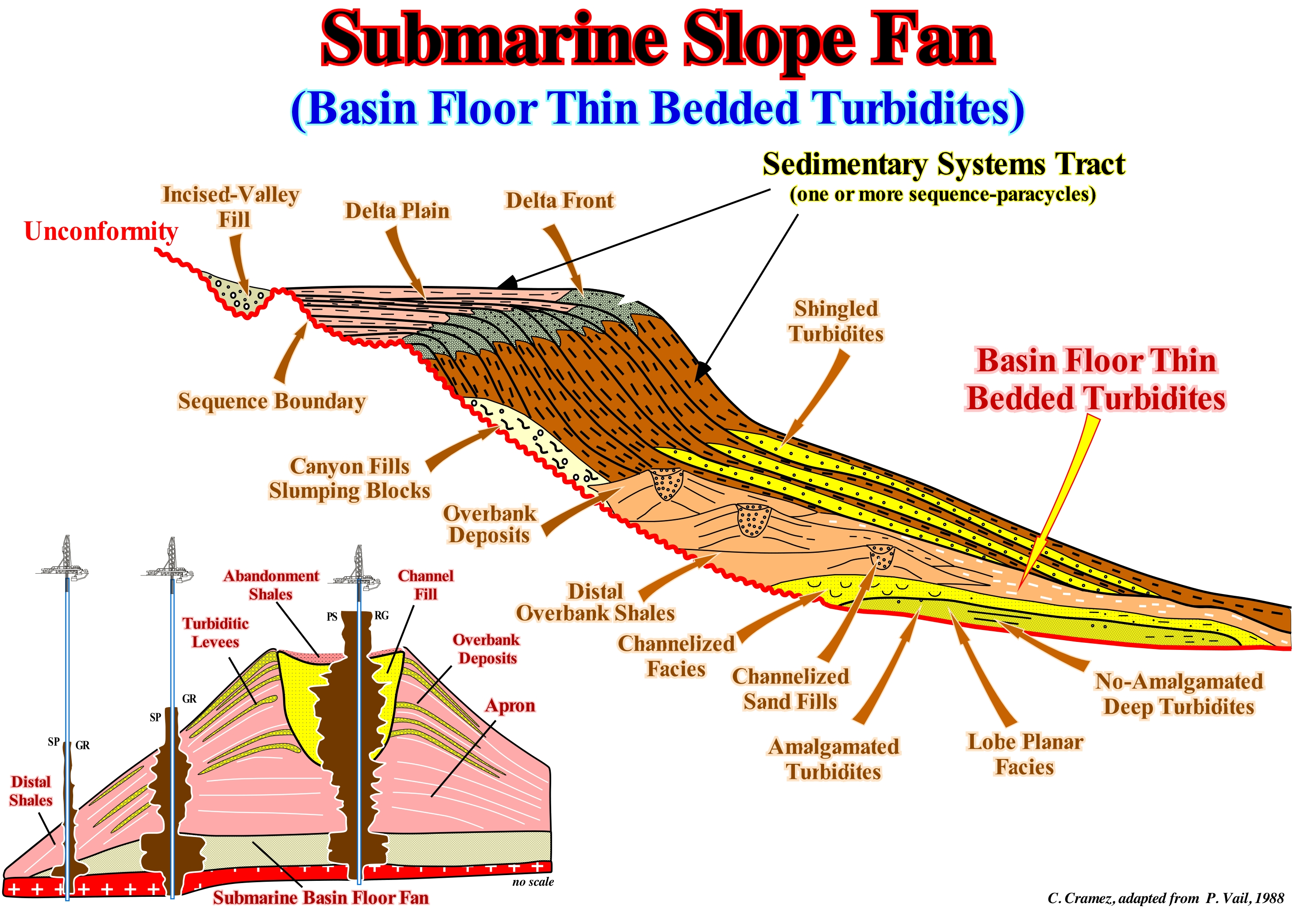
On the basis of field observations (1:1 scale), Mutti (1977, 1992) defined a turbidite facies tract as: "A lateral association of genetic facies that can be observed inside a single bed or a packet of strictly equivalent beds in time" that can develop either in the direction of the turbiditic current or against the current. However, for Mutti, the lateral facies tracts refer, mainly, to the changes of facies that are observed in the direction parallel to the flow. The recognition of facies tracts has two limitations: (i) The first is related to the fact that facies tracts can just be established within precise time correlation patterns, that is, within fine stratigraphic unities, but physically present, i.e., can be mappable ; (ii) The second limitation is represented by the variations of very low gradient facies that the majority of the systems suffers over available outcrop areas. This means that a very particular attention has to be paid when comparing the turbidite systems of E. Mutti and of P. Vail, since the scientific approach and, above all, the scales of observation are, completely, different. Mutti's model was based on field observations (mesoscopic observation scale). Vail's model relied, mainly, on observations of seismic lines (macroscopic observation scale). This type of turbidite deposits is present, in the turbiditic systems of Mutti and in the submarine fans of Vail. In Mutti's model, they occur in the distal parts of the of Type-1 and Type-2 turbidites lobes, where there is, always, an alternation of fine sandy and clayey intervals. However, as illustrated in this figure, what Peter Vail calls "Finely Stratified Base Turbidites" corresponds more to the distal shales of the submarine slope fans (SSF) covering the submarine basin floor fans (SBFF) of a sequence-cycle. It is important not to forget Mutti studied the turbidite deposits, especially, at the mesoscopic scale, i.e., the scale of the outcrop and facies (considered from a descriptive and genetic point of view), which allowed him to consider, more or less, the following hierarchy: (i) Turbidite Complex (lasting between 106 and 107 My) ; (ii) Turbidite System, whose duration is of the order of 105 My) ; (iii) Turbiditic Stage with a duration, more or less, 104 My) ; (iv) Turbiditic Facies, whose time-duration isabout 103 My and (v) Turbidite Layer (virtually instantaneous in geological terms). In contrast, EPR geoscientists (Exxon Exploration Production Research) and particularly P. Vail studied the turbidites, especially at macroscopic scale, i.e., at the scale of the seismic lines, where continuity and geometric relations seem more evident. Vail's method allows a number of predictions, but it can not be used to predict the types of facies and the geometry of sandy bodies. Mutti considers that turbidite deposits derive, mainly, from large submarine erosional events caused by sedimentary failures, which can be induced by eustasy (absolute sea level changes), tectonics or a combination of both (relative sea level). P. Vail thinks that even in tectonically active basins, such as foreland basins, eustasy is, always, the preponderant factor. In this figure, the model proposed by P. Vail and co-authors for turbidites associated with relative sea level falls, i.e., associated with unconformities, depicts the main characteristics of the three lowstand sedimentary systems sub-groups. From bottom to top, it recognizes: (1) Submarine basin floor fans (SBFF) ; (2) Submarine Slope fans (SSF) and (3) Lowstand prograding wedge (LPW). The submarine basin floor fans (SBFF) have a planar geometry, with abrupt boundaries. They are amalgamated in the central part of the lobes and non-amalgamated in the proximal part with channelized facies. In the distal part, the facies are more shaly. Submarine slope fans (SSF) are formed by channel or depressions fills, overbank deposits, and turbiditic levees (natural marginal dikes), all of which have a wavy geometry similar to the geometry of an in-flight seagull, which P. Vail called "gull wings" structures. The lowstand prograding wedge (LPW) is, mainly, characterized by the progradational geometry of the sedimentary packages, that form it, at the base of which, in certain cases, turbidite lobes, more or less imbricated (shingled turbidites) can be found. These turbidites are associated to turbidity currents induced by ruptures and landslides of the continental ridge, which in this particular case is not the basin edge, since the basin has no shelf (lowstand geological context).
Bathyal......................................................................................................................................................................................................................................................Bathyal
Batial / Batial / Bathyal / 深海 / Батиальный (глубоководный) / Batiale /
Marine environment characterized by a water-depth between 200 and 3,500 meters. Three subenvironments can be considered: (i) Upper Bathyal, with a water-depth between 200 and 500 meters; (ii) Middle Bathyal, with a water-depth between 500 and 1,000 meters; and (iii) Lower Bathyall, with a water-depth between 1,000 and 3,500 meters.
See: « Abyssal »
&
« Deep Seafloor »
&
« Physiographic (province) »
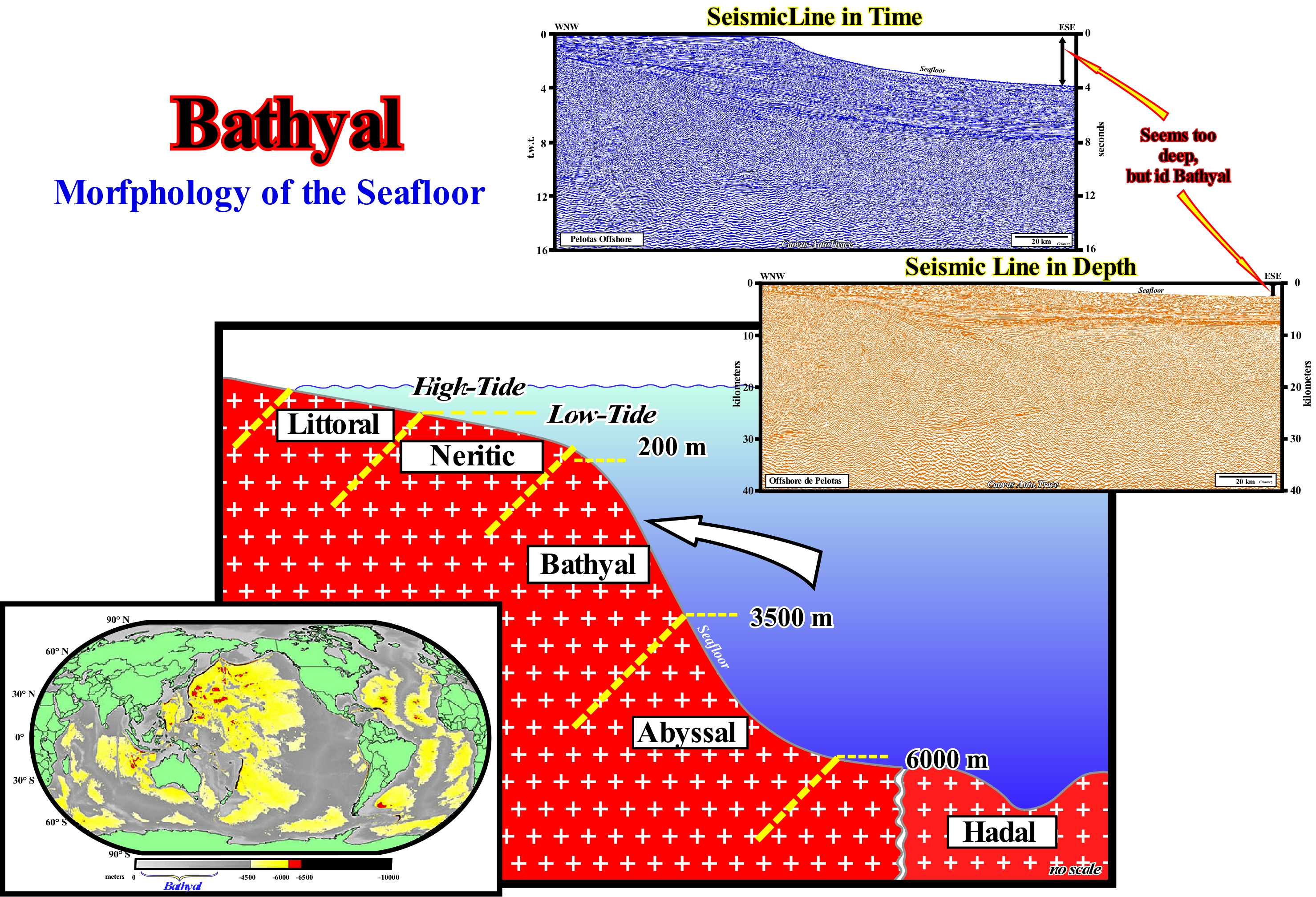
As illustrated in this figure, take into account that the morphology of the sea-floor, and in particular the water-depth, can only be, correctly, determined in the conventional offshore seismic lines when they are in depth, which requires a special reprocessing and, a more or less, accurate knowledge of interval velocities (that is why depth seismic lines are expensive and, often, not available). An abrupt variation of the water-depth, which is very frequent in the divergent margins, as illustrated here, on the offshore of the Pelotas basin (Uruguay/Brazil), induces a very important seismic pitfall, which modifies, substantially, the morphology the bottom of the sea and the geometry of the underlying reflectors. Seismic waves are retarded within the water, in which they have a slower velocity than when they pass through the sediments which, naturally, pull-up the reflectors beneath the great depth-water. Except for the upper limit of the bathyal environment, which is consensual and which corresponds to 200 m of water-depth (lower limit of the continental shelf), the lower limit varies function of the geoscientists between 2,000 and 4,000 meters. In the sequential stratigraphy, there is a tendency to consider the upper limit of the abyssal environment as the basal edge of the continental slope. It is from this edge that, within a sequence-cycle, the submarine basin floor fan cones (SBFF) are deposited, which are, almost always, covered by the submarine slope fans (SSF), since it is from this edge (base of the continental rise) that the turbiditic currents begin to decelerate. The abyssal environment is the domain of sediments deposited during significant relative sea level falls, i.e., the submarine basin floor fan and submarine slope fan. In a cycle of the relative sea level changes curve, which is the result of the combination of the eustatic curve (absolute or eustatic sea level changes, i.e., supposed to be global and referenced to the Earth's centre) and tectonics (subsidence or uplift of the sea-floor), the submarine slope fans (CST) are deposited when the relative sea level starts to rise (ascending sector with concave geometry of the relative sea level change curve). Overlying the basin floor fans, in the bathyal environment are deposited the proximal sediments of the lowstand prograding wedge (LPW), which is the upper sub-group of the lowstand systems tracts group (GLST). The lowstand systems tracts sub-groups (SBFF, SFF, and LPW) rest against the lower unconformity of the sequence-cycle by onlapping. The age of submarine basin floor fan (SBFF) suggests the more accurate age of the relative sea level fall responsible for the erosional surface, which underlines the lower unconformity of the sequence-cycle. Not only do they deposit during relative sea level fall, but they also fossilize the minimum hiatus between the preceding eustatic cycle and the eustatic cycle to which they belong. In the lowstand systems tracts sub-groups o , which are, from the bottom up: (i) Basin Floor Fans (BFF) ; (ii) Submarine Slope Fan (SSF) and (iii) Lowstand prograding Wedge (LP), the water-depth varies greatly (due to relative sea level changes and to the thickness of deposited sediments). The coastal onlapping of lowstand prograding wedge (LPW) fossilize, almost always, the bathyal environment (at the level of the lower unconformity of the sequence-cycle). The downlaps of the lowstand prograding wedge (PNB) fossilize the underlying submarine slope fans (SSF). The onlaps of the lowstand prograding wedge are coastal onlaps deposited under relatively small water-depth. The downlaps, with opposite vergence, form the gull-wings structures of the submarine slope fans (SSF) fossilizing, in general, the continental rise or a part of the abyssal plain (at the level of the lower unconformity). The upper part of the submarine basin floor fans (CSB), in which distal and proximal marine onlaps are almost always well visible, although, sometimes, deformed by differential compaction, are always defined in the abyssal zone or in the abyssal plain, particularly when they are disconnected from the base slope of the continental slope.
Bathypelagic (Organism)..........................................................................................................................................Bathypélagique (Organisme)
Batipelágico / Batipelágico (organismo) / Bathypelagic / 深海区 / Батипелагический (организм) / Batipelagico /
Organism that lives in the pelagic zone whose water-depth ranges between 1,000 to 4,000 meters. Bathypelagic organisms are, mostly, black, red or transparent, which makes them, practically, invisible to biological light. The most common bathypelagic fish have, relatively, small dimensions (less than 10 centimeters), which reduces, substantially, the metabolic needs.
See: « Bathyal »
&
« Benthonic »
&
« Biostratigraphy »
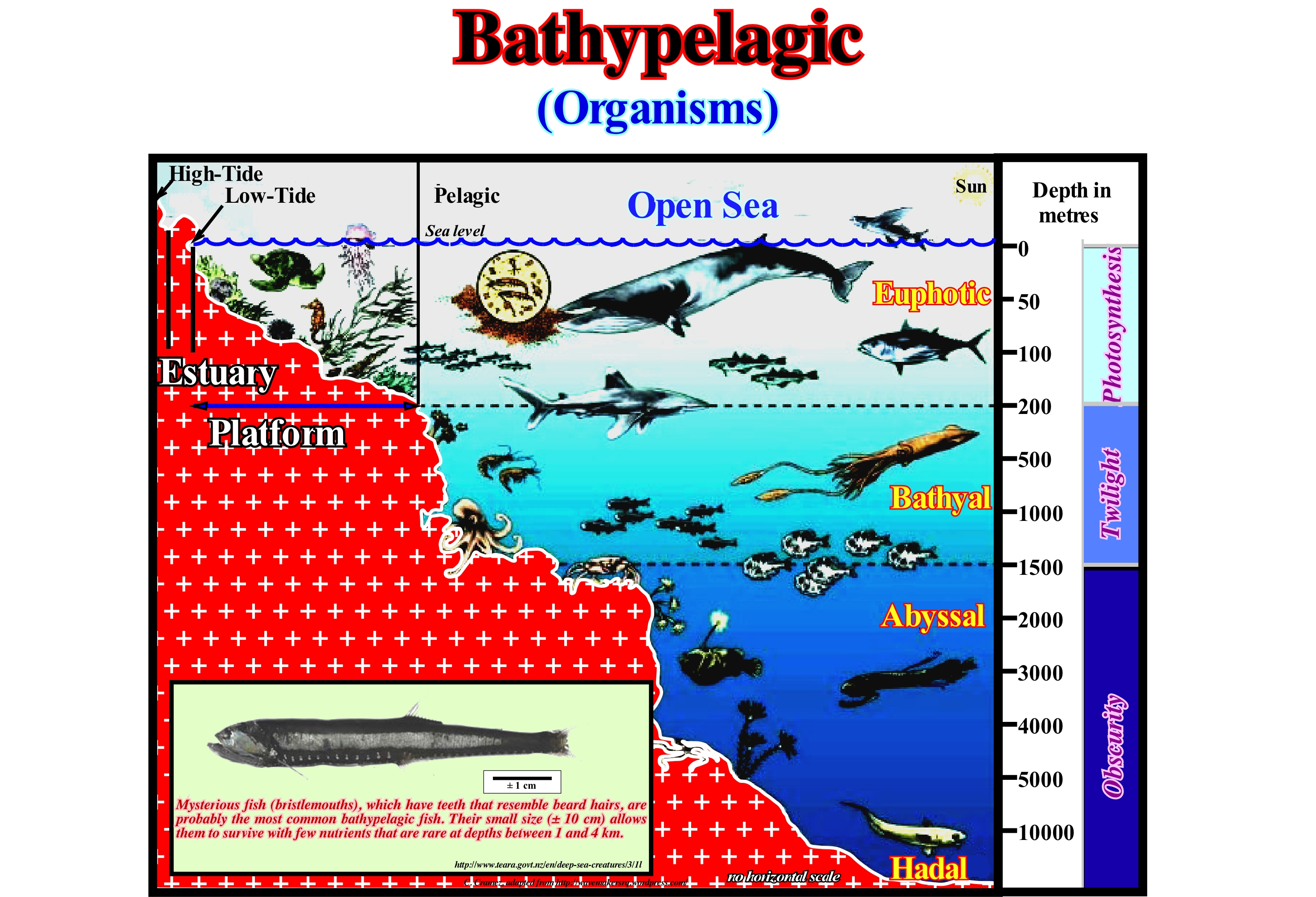
A bathypelagic organism is an organism that lives in the bathyal zone, called, also, the bathypelagic zone, i.e. the open sea zone (water-depth intermediate) that extends to a depth, which varies according to the conditions and the geoscientists, between 1,000-4,000 meters of depth. Bathypelagic organisms are organisms that live under the photic zone, either in the twilight zone or in the dark zone. Above the bathypelagic zone is the mesopelagic zone, where the mesopelagic organisms live, and below the abyssopelagic zone, in which alive the abyssopelagic organisms. The average temperature of the bathypelagic zone is around 4° C. Although the bathypelagic zone is much larger in volume than in the euphotic zone (lower limit can reach 200 meters in depth), which it is much less dense in organisms. As sunlight does not reach the bathypelagic zone, there is no primary production (production of organic compounds from atmospheric or aquatic carbon dioxide from photosynthesis or chemosynthesis*). Many of the bathypelagic organisms do not have eyes. Others, such as the snake fish (Chauliodus danae) or the snake shark (Chlamydoselachus anguineus) have eyes. Many forms of the nekton ** live in the bathyal zone, such as squids, large whales, octopuses, etc. This area is difficult for fish to live in. Sponges, brachiopoda, starfish, echinoderms and others are common in the bathyal zone. Fish become very energy efficient, since nutrients are, especially, difficult to find there. Many fish have very slow metabolisms to conserve energy. On the other hand, in this zone the fish have weak muscles, a soft skin and viscous organs. Whales are by far the largest bathypelagic organisms.
(*) Production of organic matter by oxidation of mineral substances without resorting to sunlight. Chemosynthesis is divided into two stages: (i) Formation of NADPH (nicotinamide adenine dinucleotide phosphate or adenine dinucleotide phosphate and nicotinamide) and ATP (triphosphate of adenosine or adenosine triphosphate) using the energy released by certain chemical reactions of oxidation that occur in the environment and (ii) Reduction of CO2 which leads to the synthesis of organic substances.
(**) Nekton ("to swim") as opposed to plankton is a group of marine organisms whose ability to swim is such that they can move against currents (fish, some crustaceans, cephalopods, marine mammals, etc.).
Bay....................................................................................................................................................................................................................................................................................Baie
Baía / Bahía / Bucht, Bai / 湾 / Залив / Baia /
Water-body, partially, surrounded by land, sometimes, smaller than a gulf. A narrow bay with steep banks is a fjord, while a cove is a, more or less, circular bay with a small entrance. Some geoscientists consider the surface of a bay varies between 200 km2 (cove or small gulf) and 500 km2 (gulf). In sequential stratigraphy, the bay-line, where the water-courses, practically, reach the provisional equilibrium profile, is the seaward limit of the river deposits, which are not, directly, conditioned by relative sea level changes.
See: « Bayline »
&
« Depositional Shoreline Break »
&
« Basin Edge »
In this figure is illustrated one of the largest bays in the world (Hudson Bay), which is situated in the north of Canada, west of the Baffin Sea and a small bay (Bay of St. Martin of Porto) in the Portuguese coast. In sequential stratigraphy, one should not confuse a bay, which is a water-body surrounded by land, whose dimensions are variable, with the bay-line. The bay-line is the distal (seaward) boundary of fluvial deposits, i.e., the line separating the fluvial deposits (with little or no influence of the relative sea level changes*) from the coastal plain deposits, where relative sea level changes control the available space for sediments (accommodation). In other words, the bayline, which can move upstream when the shoreline progradation is accompanied by aggradation, is the continentward limit of the Posamentier and Vail (1988) coastal wedge or coastal prism. The coastal wedge, as its name suggests has wedge-shaped and extends continentward by onlapping over the preexistent topography. The concept of the bay-line is the consequence of the conjecture assumed by Posamentier and Vail, that deltaic deposition occurs when a water-course encounters an almost immobile water-body body, like a bay, and its velocity decreases, almost, instantaneously. For them the coastal plain is formed by progradational processes of the sea-floor rather than by exhumation, and the sediments accumulate on the coastal plain, during the progradation of the shoreline, forming what they call coastal wedge, which includes fluvial and shallow-water deposits. The bay-line is the limit between the coastal plain and the alluvial plain. Upstream of the bay-line, relative sea level change have, practically, any influence on depositional systems. For Posamentier and Vail, the bay-line is not only the line where the profiles of the water-courses are adjusted, but where the delta deposits initiate. Once the water currents find a water-body, the velocity of flow, abruptly, decreases. Consequently, the occurrence of an area of bays and lagoons along the coastline, with an upstream gradual passage to the rivers is, theoretically, almost, mandatory. However, certain geoscientists consider that the encounter of a water-stream with a immobile water-body, which controls the provisional equilibrium profile of the streams, occurs at the mouth of the streams, i.e., at the head of the deltas, and not at the bay-line. Many geoscientists ask how a delta can advance into the sea during a period of stability of the relative sea level, which occurs after a marine ingression (as the Vail's model constrains), whether the sediments, which the water-courses carry, settle down in the bays and lagoons? In the sequential stratigraphy, along a chronostratigraphic line (depositional surfaces), which are, easily, recognized on regional seismic lines oriented in the direction of the terrigeneous influx (usually perpendicular to the shoreline), from the continent to to the abyssal plain, there are several slope breaks (slope changes) : (i) Alluvial break or bay-line break, which separates alluvial deposits from coastal wedge ; (ii) Coastal break**, which corresponds, more or less, to the shoreline, which is, permanently, subject to displacement and transformation caused by the action of tides, marine currents, relative sea level changes, etc. separates non-marine coastal deposits from marine deposits ; (iii) Continental break, which is,sometimes, the basin edge, emphasizes the upper limit of the continental slope, and (v) Continental slope break, which separates slope deposits from abyssal plain deposits and marks, more or less, the beginning of the abyssal plain.
(*) Relative sea level is ta local sea level, usually, referenced to the top of the continental crust (base of sediments) or to the sea-floor. It is the result of the combined action of tectonics and the absolute (eustatic) sea level , which is supposed to be global and referenced to the Earth's centre.
(**) On the seismic lines, taking into account the seismic resolution, the depositional coast break coincides with the shoreline. When a geoscientist says on a given tentative interpretation, in a given sequence-cycle, the basin has no shelf, it is very possible that, in reality, it has a platform but that the water-depth is under seismic resolution. This is what happens in the upper part of the Mahakam delta (Borneo offshore), where all exploration wells recognized a stacking of sedimentary transgressions, with an average thickness of 20-30 meters, where the tentative geological interpretations of the seismic lines suggest, simply, a vertical stacking of hghstand prograding wedges (sedimentary regressions).
Bay-Mouth..................................................................................................................................................................................................Embouchure (De la baie)
Embocadura (de baía) / Desembocadura (da bahía)/ Mund (die Bucht) / 口(湾) / Устье (залива) / Bocca di baia /
Entrance of a bay or the part of the bay that is in contact, serving as connection, with the main water-body.
See: « Bay-line »
&
« Equilibrium Point »
&
« Alluvial Plain »
In general, the bay-mouth, i.e., the line by which the water of a bay enters into connection with the main mass of water (sea or ocean) is underlined by a spit or sand-spit called a bay-mouth bar. This spit is, largely, induced by the coastal currents. As illustrated in this figure, the shoreline is, practically, the spit that almost closes the bay. In sequential stratigraphy, the concept of the bay-line, which corresponds to the line of demarcation between fluvial and paralic-deltaic environments, raises certain problems. For the followers of sequential stratigraphy, it is the bay-line, and not the shoreline, which determines the base level at which the provisional equilibrium profiles of the water-courses are established. All models of Posamentier et al. (1988) and Posamentier and Vail (1988) assume,always, along the shoreline, an area with the bays or lagoons, which serves as a reference for the provisional equilibrium profiles of the rivers. They define the point of equilibrium as the point of the continental margin, where subsidence (tectonics) and eustasy balance. When sea level rises or falls, the equilibrium point moves continentward or seaward. Certain geoscientists consider, for instance, the delta deposition is done where the currents find a stable water-body and the velocity of flow decreases abruptly. For these geoscientists, such conditions lie near the mouth of the rivers and not in the bay-line (sequential stratigraphy). Vail and Posamentier consider that when equilibrium points (where subsidence and eustasy compensate and for which the currents harmonize) migrate seaward and the equilibrium profiles of the rivers move accordingly, there is a concomitant deposition of fluvial deposits. Fluvial deposition is done regardless of the position of the equilibrium point continentward of the bay-line. However, for certain geoscientists, these hypotheses are not supported by observations and do not take into account tectonic activity, entropy and relative sea level changes.
Bay-Mouth Bar................................................................................................................................................Barre d'embouchure (De la baie)
Banco de desembocadura (de baía) / Barra de desembocadura (de bahía) / Bay-Mound-Bar / 湾口坝 / Бар в устье залива / Bocca bar (la baia) /
Sandy accumulation induced by longshore drift. Usually, it is a barrier-bar that closes, completely, the bay's access, isolating it from the main water-body. These bars are, usually, formed of sand and gravel carried by the longshore drift (littoral current) and deposited in the less turbulent part of the current.
See: " Bay "
Bayline....................................................................................................................................................................................................................................Ligne de baie
Linha de baía / Línea de bahía / Line - Bucht / 线湾 / Линия залива / Linea di baia /
Demarcation line between sedimentary zones characterized by subaerial and marine accommodation. Limit between fluvial and paralic/deltaic environment. The bayline should not be confused with the shoreline, which marks, upstream, the limit of marine environments. In certain cases (absence of bays or lagoons), the bayline may have the same position as the shoreline. It is used as a reference for river provisional equilibrium profiles.
See: « Coastline, Shoreline »
&
« Equilibrium Point »
&
« Graded Profile »
In sequential stratigraphy, the successive positions of the bay-line limit, upstream, the coastal wedge and not the coastal deposits. Indeed, Posamentier and Vail (1988) who consider the deltaic deposition occurs when a water-course finds a water-body, almost immobile, defined the bayline, more or less, as follows: (i) The coastal plain forms by progradation processes of sea-floor, rather than exhumation ; (ii) The sediments that accumulate on the coastal plain during the progradation of the coastline form part of what is called the "coastal wedge", which includes river and shallow-water deposits ; (iii) The coastal wedge or coastal prism is wedge-shaped and extends continentward by onlapping on the pre-existing topography ; (iv) The upstream boundary of the coastal wedge is the bayline, which may move continentward when the progradation of the shoreline is accompanied by aggradation ; (v) The bayline is the boundary between the coastal plain and the alluvial plain; (vi) Upstream of the bay-line, relative sea level changes have, practically, no influence on depositional systems. However, for some geoscientists, the encounter of a water-course with an almost immobile water-body, which controls the (provisional) equilibrium profile of the watercourses occurs at the mouth of a stream, that is, at the head of the deltas, not at the bayline. Thus, when speaking about equilibrium profiles of rivers, geoscientists should say whether the profile is in relation to the bayline (Vail's position) or to the shoreline (Miall's position, for example). A depositional surface (chronostratigraphic line) has several slope breaks. From deep-water to continent, the main breaks of the depositional surface are: (i) Lower Break of the Continental Slope, which separates the abyssal plain from the base of the continental slope ; (ii) Continental Break, which marks the boundary between the continental slope and the continental shelf (when the basin has no shelf) marks between the continental slope and the coastal plain (lowstand geological conditions) or in other words, when basin edge coincides with the continental break ; (iii) Depositional Coastal Break, which corresponds, more or less, to the shoreline and separates the marine deposits from the paralic deposits (deposited upstream of the coastline) and (iv) Bayline or Alluvial Break, which corresponds to the boundary between the fluvial and coastal plain. It is this alluvial break that, according to the followers of sequential stratigraphy, defines the bayline, that is, the line where the equilibrium (provisional) profiles of the rivers are horizontal and where the effects of subsidence and eustasy (changes in absolute or eustatic sea level , which is the global sea level referenced to the Earth’s centre) cancel out (as shown in this figure). On this geological tentative interpretation of a Canvas auto-trace of a detail of a Labrador offshore seismic line, the upper unconformity separates two sequence-cycles. Throughout this unconformity, two slope breaks (change in dip of the depositional surface) are, easily, recognized. The first, (more seaward), corresponds to the continental edge of the highstand prograding wedge (HPW) of the lower sequence-cycle (at that time, the basin does not have a shelf, i.e., the shoreline coincided, more or less, with the basin edge and with the continental edge). The second break (upstream of the first one corresponds to the bay-line, which separates, in the highstand prograding wedge of the lower sequence-cycle, the fluvial deposits (upstream of the bay-line), from the coastal deposits (influenced by relative sea level changes). Above the upper unconformity, several sequence boundaries are recognized by the seismic surfaces emphasized by coastal onlaps, as well as, the transgressive interval. This transgressive interval corresponds to the set of five (5) marine ingression increments increasingly important (eustatic paracycles), which induced five sedimentary regressions increasingly smaller (sequence-paracycles), within, at least, two depositional systems are, more or less, evident.
Beach.....................................................................................................................................................................................................................................................................Plage
Praia / Playa / Strand / 海滩 / пляж / Spiaggia /
Type of coast with a strand consisting of terrigenous, sand, sand-silt and coarse detrital materials (cobbles and pebbles). A beach is a landform alongside a water-body of water which consists of loose particles (such as sand, gravel, pebbles, etc.), which can, also, be biologiocal in origin, such as mollusc shells or coraline algae.
See: « Shoreface »
&
« Littoral »
&
« Coastal Karst »
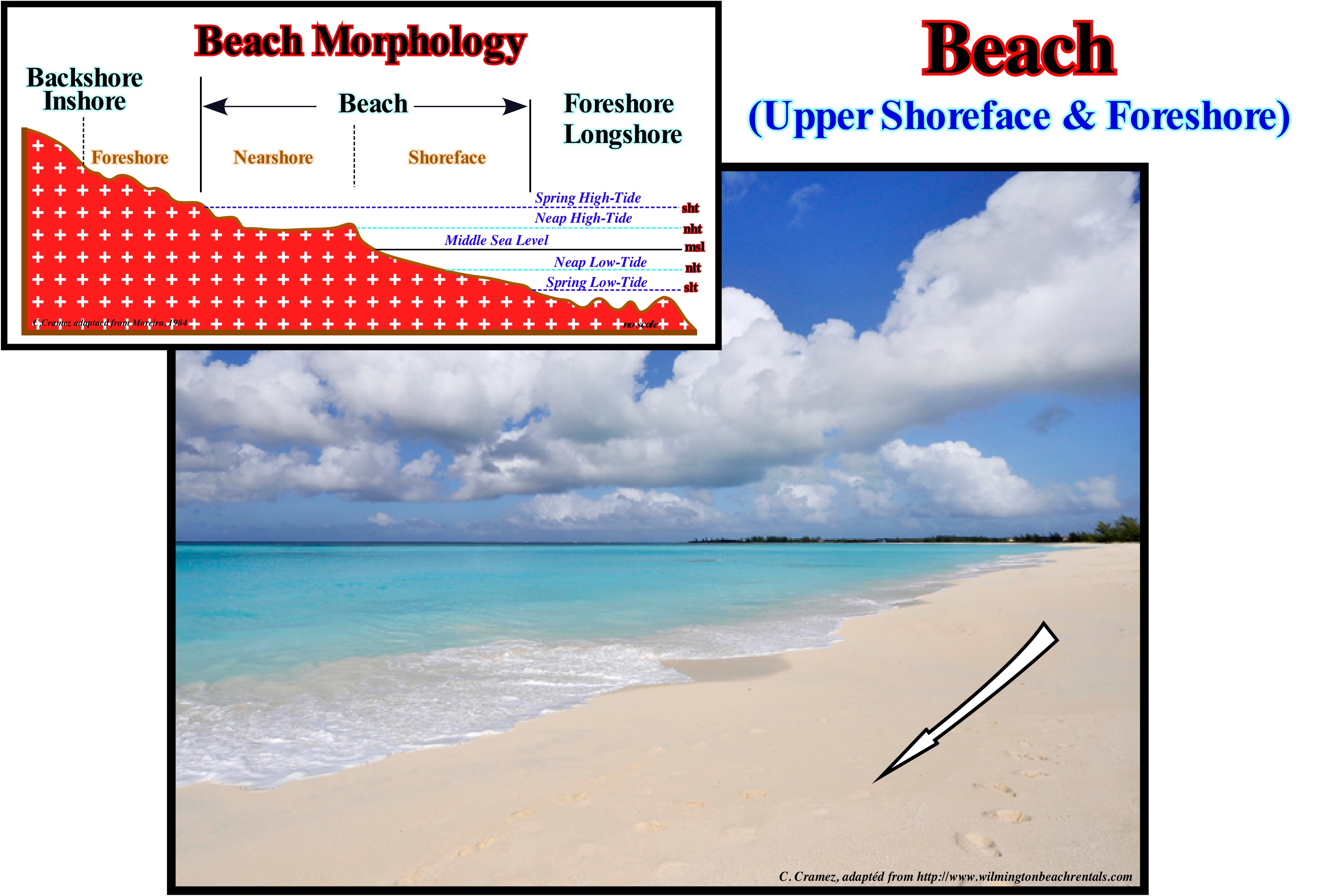
In the Atlantic islands, the beaches with coarse debris are called beach of pebbles or just pebbles. The beaches made up of sand, pebbles and blocks are the mixed beaches. A shingle beach (also referred to as rocky beach or pebble beach) is a beach armoured with pebbles or small to medium-size cobbles (as opposed to fine sand). Typically, the stone composition may grade from characteristic sizes ranging from 2 to 200 millimetres (0.1 to 7.9 in) diameter. Sandy beaches are the most frequent. The beaches can have a rectilinear or arched shape. The curvature of the beach is defined, morphometrically, as the radius of the circumference whose string is the segment of line that joins the extreme points of the beach. The length, width, orientation and slope of the beach are other important parameters that, often, have to be taken into account. The slope of the beach varies with the granulometry of the materials. It is larger when the beach is formed of coarse sand, more or less, between 20°/22°. On beaches made of pebbles, the slope can reach 20°-30°. The beach is characterized by a specific morphology whose classification varies with geoscientists. As illustrated, theoretically, five zones can be recognized in the morphology of a beach: (i) Backshore or Inshore: form of relief constituting the inner limit of the beach, which can be a cliff or a barrier bar, isolating or not an interior lagoon ; (ii) Foreshore: the upper part of the beach, with steep slope, only reached by the waves in the spring high-tides and storms; when large enough, it presents obstacle dunes in form of dome (backshore dunes); the surface reached by the waves is modelled in berms ; (iii) Nearshore: part of the beach that extends in the space reached by swash currents, between the levels of the neap high-tide and neap low-tide ; it is separated from the backshore by the lower berm of the beach and of the foreshore by the inflection line ; (iv) Foreshore: corresponds to the lower part of the strand and comprises the space that extends between the limits reached by the low-tide, in spring and neap tides ; the slope is very weak and the material is thin, but may contain coarse materials transported longitudinally ; (v) Foreshore or Longshore: the part of the beach, always, submerged and extending to the open sea, from the limit of the lower-tides, by an space not well defined, which for some geoscientists, is the zone of surf ; the bottom is modelled by longshore ridges and longshorerunnels.
Beach Cusp..................................................................................................................................................................................................Croissant de plage
Crescente de praia / Creciente de playa / Strandhörner / 海滩上风口浪尖 / Пляжевый фестон / Crescente de spiaggia /
Accumulation of sand or coarser material, with an arch structure, formed on the beaches. The arc is composed of the coarser material, while the inner part (under the arc) is formed by the finer material. Such accumulations are found on almost all beaches in the world, but they are particularly frequent on beaches where coarse material is predominant. They appear, almost always, in regular patterns. The size and distance between the crescents, along the beach is, more or less, constant.
See: « Shoreface »
&
« Littoral »
&
« Depositional Environment»
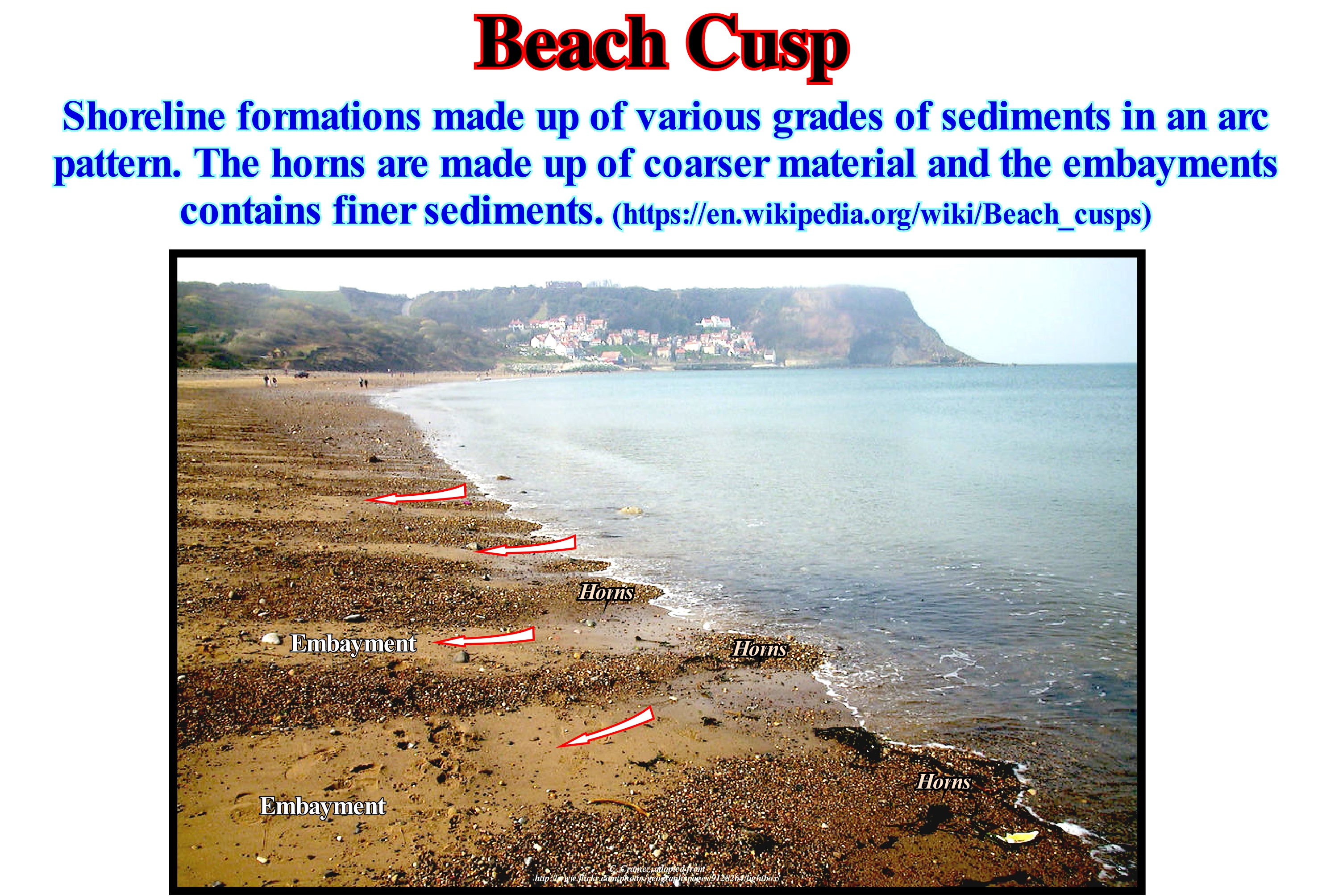
The two less refutable theories to explain the beach cusp are: (i) Marginal Perpendicular Wave Theory and (ii) Self-Organization Theory. The first is based on the interaction, near the coastline, between incoming waves and the waves that form parallel to the coastline (marginal perpendiculars). The arrival of incoming waves in the waters near the coastline creates perpendicular waves (transverse waves) to the incoming waves. When two transverse waves with opposite directions meet they form a perpendicular current, called marginal perpendicular. The movements of these waves are, more or less, constant allowing to define two regions: (a) The nodal point or node* and (ii) The antinodal or antinode point (see Nodal and Antinodal Point). Interference between waves generates a stationary wave pattern with one or more nodes (where there is no vertical movement), and two or more antinodes (where vertical motion is maximum, ridges and arches). The antinodal point is the point where all movement forms when water rises or falls and creates a series of crests and trough. Between the antinodal points there are the nodal points, where there is no movement. The second theory, which was abandoned in an early stage, was revived by the use of computers in marine geology. Two main phenomena explain the beach cusps. A positive feedback between the morphology of the beach and the flow of water creates a topographical pattern. The space between the ends (horns) of the beach cusps seems to correspond to a negative feedback between the amount of erosion and deposition of a crescent.
(*) A node or nodal point is a point along a stationary wave where the wave has minimal amplitude. For example, on a guitar string, the ends of the string are the nodes. By changing the position of one of the nods a guitarist changes the effective length of the string's vibration and thus the note played. The opposite of a node is an antinode, that is to say, a point where the amplitude of the stable wave is maximum. Obviously the antinodes occur halfway between the nodes.
Beach Drifting (Foreshore drift).........................................................................................................Courant de dérive de plage
Corrente de Deriva de Praia (corrente em zigue-zague) / Corriente de deriva de la playa / Strandvertriffung / 泳滩漂流, 滨漂移 / Передвижение наноса вдоль берега / Drift corrente della spiaggia /
Longitudinal current formed on the beaches, outside the surfing area, affected by swash currents, as a consequence of the accumulation of water (and sediments) of uprush and backwash currents, when the surf (breaking) is obliqued to the coast. Synonym of Coastal Drift Current or Littoral Current.
See: « Stream »
&
« Littoral Current, Longshore Drift, Offshore Drift »
&
« Surge Current »
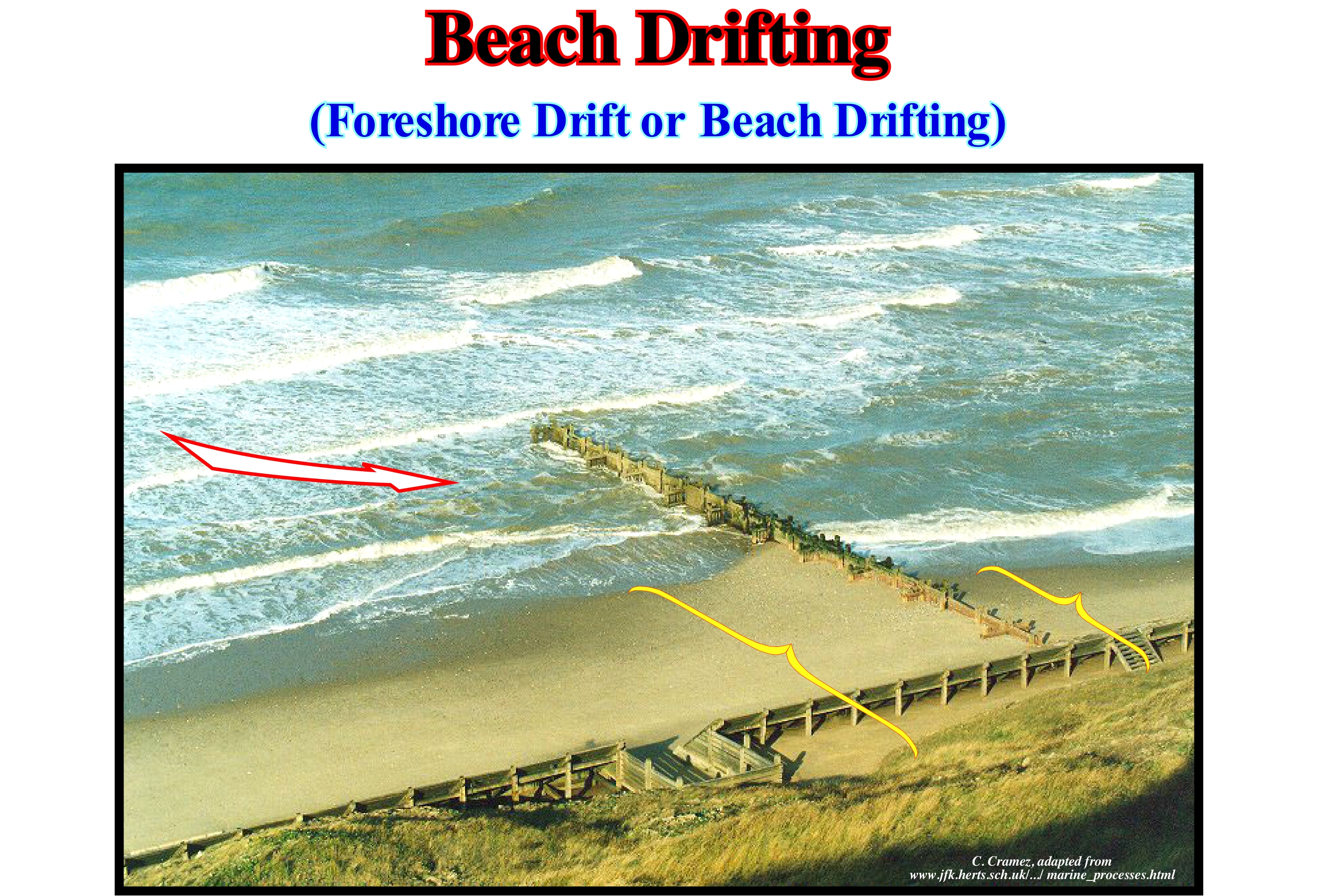
The beach drifting is, practically, the same thing as a littoral or coastal drift. It is the result of the interaction between the uprush and backwash currents. It transports sand. So when it encounters a barrier, such as a pier, the sand accumulates against it (in the part facing the stream), which is visible in this photograph. Although the wave direction is not too oblique to the shoreline, which means that the beach drift current is not very strong. There is much more sand on the left side of the pier (against the direction of the current) than on the right part. If nothing is done to prevent the deposition of the sand, in a few years the sedimentation will reach the end of the pier. Later, a sand stick will be formed, parallel to the coastline, but on the other side of the pier from its end. Piers or jetties are often built in the mouths of rivers where there is a strong beach drifting. The jetty on the side from which the current comes to favour sedimentation of the sand, while the jetty on the other side of the mouth protects the erosion of the beach for a certain number of meters. Among geoscientists, particularly, those dealing with environmental problems, there is some consensus on a number of hypotheses about coastal geological processes and the engineering they entail: (i) Coastline erosion is a natural process ; (ii) Erosion problems occur when dwellings or other constructions are made in the coastal zone ; (iii) Any construction on the coastline has consequences ; (iv) The stabilization of the coastline by engineering structures protects the properties of some people, but not of the public, in general ; (v) The structures built to protect the beaches may eventually destroy them, which, when built, produce a beach evolution that is difficult to reverse.
Beach Ripple-Mark (Troughs & bars)..........................................................................................................Creux et rides (De plage)
Ondulação (de praia-baixa) / Ondulación (de playa baja) / Hollows und Falten (Strand) / 凹陷和皱纹(海滩) / Впадины и складки / Troffa e bar (spiaggia) /
The sedimentary structure, more or less, linear, not consolidated, created by the breaking of the waves in the shoreface, i.e., in the lower part of the strand, which comprises the space extending between the limits reached by the spring and neap low-tides. Synonym of Troughs & Bars (of the beach) or "Ripple".
See : « Sedimentary Structure »
&
« Shoreface »
&
« Foreshore »
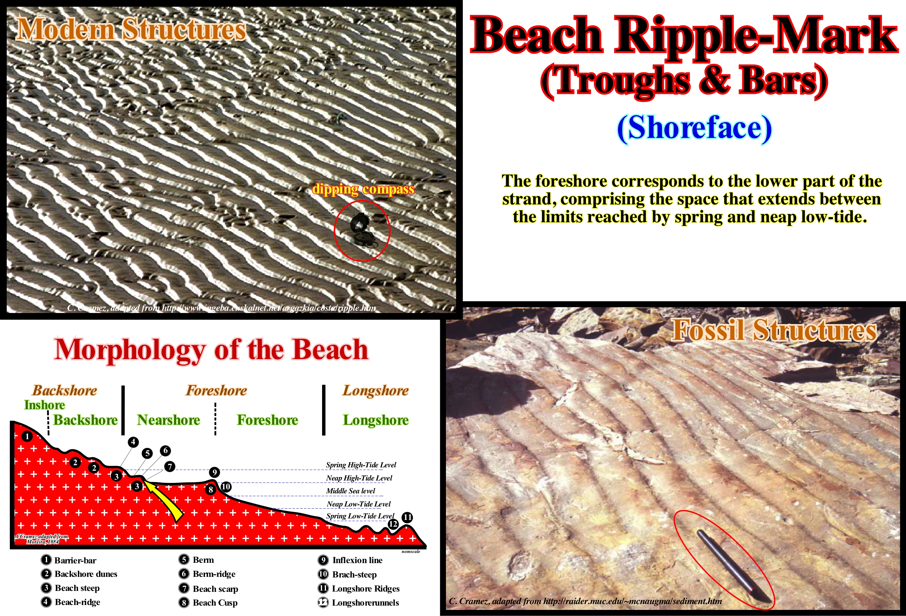
These photographs illustrate modern beach ripple-marks (troughs & bars) in the United States (left) and ancient beach ripple-marks on the stratification plane of a sandy layer. Both beach ripple-marks were, probably, formed when the sediments were transported by a, more or less, turbulent flow of the swash currents, in particular, the backwash current. On the surface of the foreshore can be observed bioturbation marks, that is to say, marks of alive beings, as, for instance, trails, footprints, burrows, mounds, pellets, pits and exits of crabs or sandworm, birds feet, etc., but also low amplitude beach ripple-marks (3-15 cm), linear, symmetrical or dissymmetrical, parallel to each other and, more or less, perpendicular to the beach slope, as illustrated above. These beach ripple-marks called, sometimes, just ripple-marks are induced by the swash currents. As the sea-waves approach the shoreline, the orbits of the water-particles become more elliptical in depth as the water-depth decreases. Thus, as water-particles take longer to travel through their ellipses, the waves slow down. As they slow down, the water-particles approach each other and rise in height from the waves, making them more sharp, until the waves break and fall into the surf zone. Since oscillation waves turn into translation waves they break. This is how the uprush current is formed. It flows continentward, perpendicularly, to the direction of the waves. The backwash current flows seaward along the line of greater slope of the beach. The foreshore ripples-marks are induced by these currents, since sand grains carried by saltation tend to form small dunes and ripples with cross bedding stratification. As the velocity of the currents increases the loading of the saltation charge increases inducing the migration of the ripples towards the flow direction, with erosion on the side resisting the flow and deposition on the other (in the direction of flow).
Beach Ripple-Marks........................................................................................................................................................................Rides de Plage
Ondulações de praia / Ondulaciones de playa / Strandripeln / 海滩纹波-商标 / Береговой вал / Ondulazione de spiaggia, Increspature di spiaggia /
Small linear or sinusoidal, parallel waves, modeled on the surfaces of wet sand (beach and sea bottom) by the symmetrical or dissymmetric currents with the flank, slightly, inclined towards the current. Synonym of Trough & Bars.
See: « Wave »
&
« Swell (sea) »
&
« Beach-Ripple Mark (troughs & bars) »
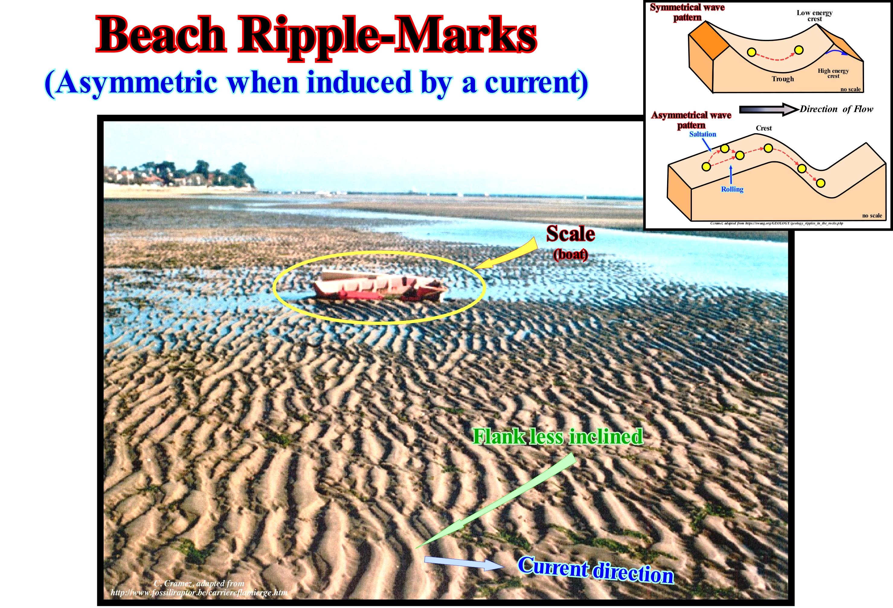
A sedimentary structure is a structure that formed during the deposition of the sedimentary particles. Sedimentary structures, such as cross-bedding, graded bedding, hummocky cross-stratification, beach undulations that certain geoscientists call beach ripple-marks, are used in stratigraphic studies to indicate the original position of the strata in geologically complex terrains and to understand the depositional environment. Ripples form, usually, under running water conditions at the bottom of the lower flow regime. There are two types of beach ripples: (i) Symmetrical, that are often found on beaches and created by two current directions, as for instance, on beaches, the uprush and backrush currents (create ripple marks waves with pointed ridges and round troughs, which are not inclined in any direction; three common sedimentary structures that are created by these processes are the cross-breeding as in fish-bone or herring-bone cross-stratification*, flaser bedç*, and interference ripples); (ii) Asymmetric that are created by a single current, as in a river or in desert by the wind current, that creates ripple marks with pointed crests and round troughs, but which are more strongly inclined towards the direction of flow. For this reason, they can be used as paleocurrent indicators. In the majority of the present current, ripples do not form in larger sediments than coarse sand. The substratum along which the currents carrying sand, are dominated by ripples, which is not the case when the currents carry gravel. The internal structure of the ripples is a fine sand base with coarse grains deposited at the top since the grain size distribution of sand correlates with the ripples size. This is because the fine grains continue to move while the coarse grains accumulate forming a protective barrier.
(*) Type of sedimentary structure formed in tidal areas, where the current periodically flows in the opposite direction
(**) Flaser bed is a sedimentary, bi-directional, bedding pattern created when a sediment is exposed to intermittent flows, leading to alternating sand and mud layers. While flaser beds, typically, form in tidal environments, they can (rarely) form in fluvial conditions (https://en.wikipedia.org/wiki/Flaser_bed). if the amount of deposited sand exceeds mud deposits, we get ripples with isolated mud drapes in ripple troughs and crests.
Beach-rock (Cemented)......................................................................................................................................................Grès de plage cimenté
Grés de Praia (cimentado) / Arena de playa cementada / Strandsandstein / 海滩岩 / Береговая порода / Arenaria di spiaggia /
Sandstones formed by a rapid cementing of the sediments of a beach, in particular, in intra-tidal zone, which leads to the formation of characteristic lithified structures. Also called Beach Sandstone.
See: « Coastline, Shoreline »
&
« Shoreface »
&
« Sandstone »
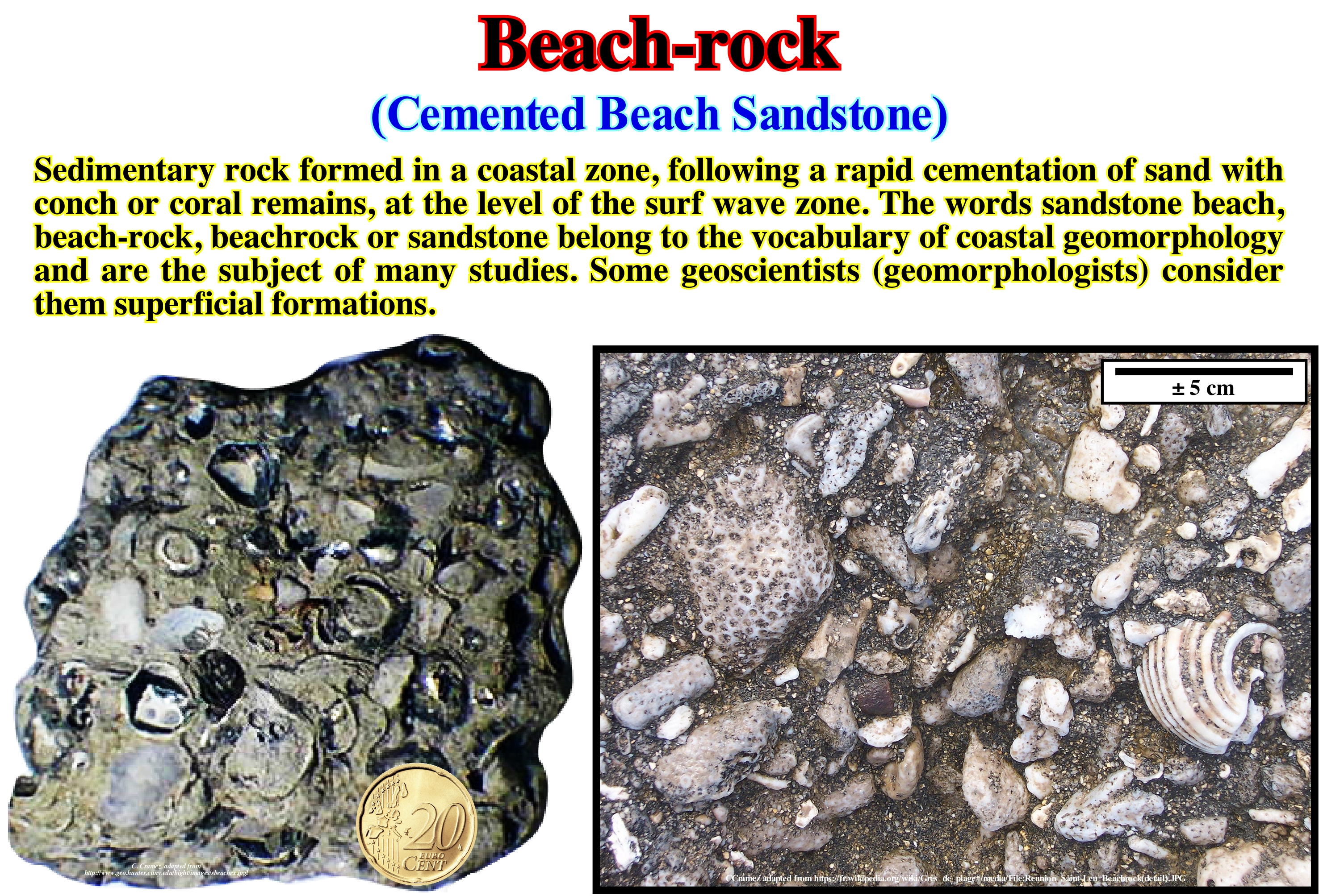
The beach-rocks (or beach sandstones) are oriented parallel to the coast line and are, usually, located a few meters from the sea water. Beach-rocks, generally, are deposited on several levels. Each level corresponds to one generation of cementation. The oldest cementation zones are located on the outside (towards the mainland), while the most recent cementation zones are located closer to the sea. All the cementing areas incline seaward. In terms of dimensions, it can be said the length of beach sandstone is very variable. It can range from a few meters to several kilometers. On the contrary, the width exceeds, rarely, 300 meters and the thickness varies between 0.3 and 300 centimeters. Due to the erosion processes prevailing in the coastal zone, beach sandstone may or may not outcrop. Coastal erosion may be the result of a relative sea level rise (subsidence plus eustasy) or a deficiency of terrigeneous influx. Either way, as long as the sands covering the beach sandstones are removed, the beach-rock outcrop. If cementation processes continue, new beach sandstones form in the intra-tidal zone. Successive relative sea-level rises, naturally, create a vertical stacking of beach sandstone. This is, particularly, true when there is any relative sea level fall between the rises (sequence-paracycle), as is the case in transgressive interval (sequence-cycle). Beach-rocks associated with the sediments of the quaternary coastal plains have many fossils as illustrated in this figure. In the sample of Staten Island, NY, USA, the matrix consists of fine to coarse sand, which is, locally, conglomerate (with rounded grains diameter is greater than 2 mm). The sand is cemented by calcite and limonite (a group of hydrated iron oxides, yellow or brownish amorphous, formed from iron oxidation of minerals). This sample contains remains of fresh-water mussels, oysters, gastropods, shark vertebrae and plant remains. In the sample from Reunion Saint-Leu, coral fragments and shells of molluscs are well recognized.
Beach Scarp (Berm)..........................................................................................................................................................................Abrupt de la plage
Abrupt (de berma) / Escarpa (de playa) / Strand Böschung / 海滩崖 / Откос пляжа (береговой уступ) / Brusco dalla spiaggia /
Scarp between two steps or consecutive beach berms. Each beach step is formed by a platform (berm) and an abrupt (ramp). The beach steps are, particularly, frequent in the surroundings of the upper limit (continentward) of the foreshore. A large abrupt (beach escarpment) exists between the shorefore and the upper shorefore in association with the inflection point, which is the downstream limit of the upper shorefore. For certain geoscientists, foreshore and nearshore forms the beach itself (foreshore of certain geoscientists). The beach steps (ramps) suggest the levels of spring and neap high-tides.
See: « Depositional Costal Break »
&
« Beach »
&
« Transgressive Interval »
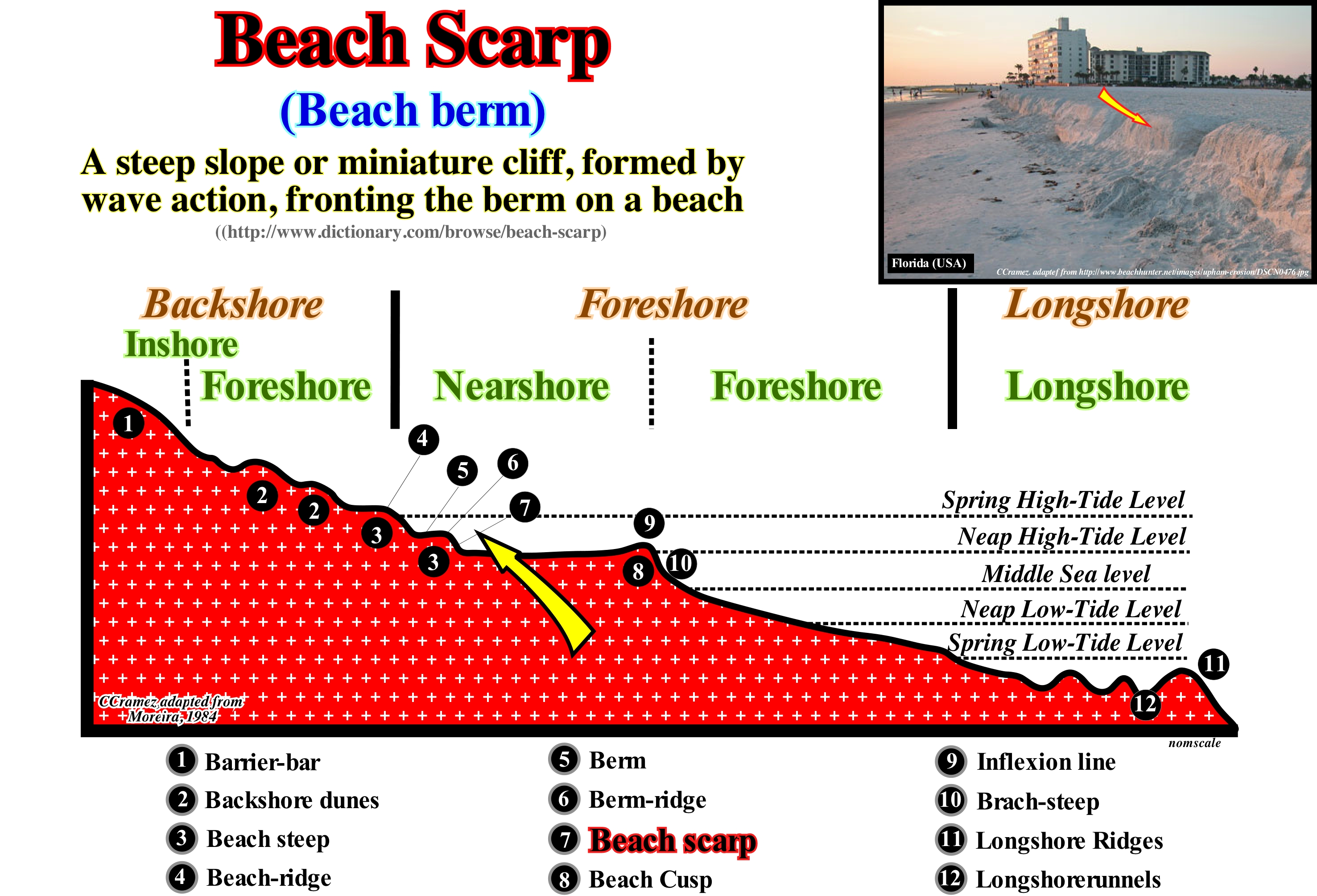
The nomenclature of the geological elements (landforms) forming the morphology of the coast, which, for most geoscientists, is the portion of the marine region that covers the area affected by the high-tide and the low-tide and whose spatial extent depends on the slope of the coast, is summarized in this geological model. The beach scarps or berm abrupts (as indicated by the number 7 in the sketch illustrated in this figure) underline the upper limit of the beach itself (foreshore), which corresponds to the lower part of the strand (space between the limits reached by the spring-tides). In the photograph (upper right corner of this figure), the small cliff marks the beach escarpment (number 10 in the geological model). The abrupt beach, located on the inside of the beach is, barely, visible in this photograph. The area upstream of the beach step (10 in this model), bounded between the deflection line (9) at the top, and the beach cusp (8), at the base, corresponds, more or less, to the nearshore, which can be considered as a large beach berm defined between the deflection line (9) and the beach scarp (7). Given its size, it can be said beach steps, obviously, are not visible in conventional seismic lines (migrated or unmigrated). The dimensions of the steps are, always, under the seismic resolution that, in general, is higher than 20-30 meters. When on a tentative geological interpretation of a seismic line, the geoscientist, who did the interpretation, proposes, within a sequence-cycle, a beach step, he is, probably, to confusing it with the shoreline or with the continental edge*. Likewise, the different beach berms (5), which limit, roughly, the nearshore with the backshore, are also not visible in conventional seismic lines. When they are proposed on a tentative geological interpretations, it is most likely that the geoscientist responsible for the tentative interpretation confused them with the retrogradation (backstepping) of the different positions of the depositional coastal break (equivalent, more or less, to the shoreline, especially on the seismic lines), which is, particularly, visible within the transgressive interval (IT) of a sequence-cycle. When the relative sea level rises (eustatic paracycle or marine ingression), the shoreline and depositional coastal break are displaced continentward, which induces the formation of a ravinment surface in the pre-existing topography. It is crucial not to confuse the relative sea level with the absolute (eustatic) sea level. The first is referenced to any fixed point on the Earth's surface, which may be the top of the continental crust (base of the sediments) or the sea-floor. The second is the global sea level referenced to the Earth's centre. The relative sea level is the result of the combined action of absolute sea level and tectonics (uplift or subsidence of the sea-floor). During the stability period of relative sea level following a marine ingression, gradually, the depositional coastal break and the shoreline (usually, more or less coincident) move downstream (seaward), since there is deposition and progradation or, in other words, there is a sedimentary regression. However, they do not reach the positions they occupied before the relative sea level rise, because the terrigeneous influx decreases due to flooding of the continent (increasing the extension of the continental shelf). A new relative sea level rise, again, displaces the depositional coastal break continentward and a new ravinment surface forms on the sediments deposited previously. This history is repeated until the relative sea level rise is in deceleration (smaller marine ingression than the previous one), which induces the beginning of the deposition of the highstand prograding wedge (HPW). Thus, it can be said within a sequence-cycle, the transgressive interval (TI) creates a retrogradational geometry that is not to be confused with the beach steep (3) and beach scarp (7) that roughly underline the levels of spring and neap high-tides.
(*) Within a sequence-cycle, during the deposit of the lowstand systems tracts group (GLST), as the basin has no self, the sediments deposit at the base or on continental slope. Thus, the basin edge, which corresponds to the upper limit of the continental slope, is in the previous sequence-cycle (the last continental edge of the preceding sequence-cycle). During the deposit of the highstand systems tracts group (GHST), as the basin has a continental shelf (transgressive interval and 1st stage of development of the highstand prograding wedge), the basin edge corresponds to the upper limit of the continental slope, that is to say, it corresponds to the continental edge.
Beach-Steep.................................................................................................................................................................................Escarpement de Plage
Escarpa de praia / Escarpa de playa / Strand Steilhang / 海滩崖 / Береговой уступ / Scarpata di spiaggia /
In the backshore, the surface reached by the waves is modelled in steps. Geoscientists call them beach-steeps or berms, which are formed by a platform (berm) and an abrupt (slope).
See: « Visor Cliff »
&
« Shoreface »
&
« Beach »
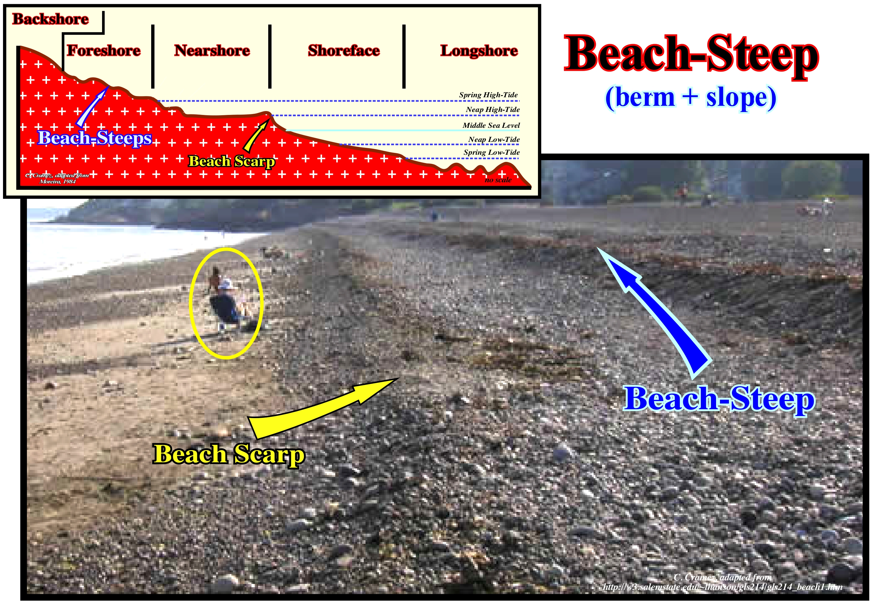
The beach-steep, that is, the abrupt step, which separates the shoreface* from the foreshore** is, clearly, visible in this photograph (Marblehead, MA, USA). The foreshore has several berms, which were formed by the coalescence of the gravel cords created every month by the high tides. Moreira (1984) says that the foreshore or beach itself corresponds to the space reached by the swash currents, between the levels of the neap high-tide and the low-tide. It is separated from the backshore by the lower step of the backshore (modelled or not in cusp) and from the shoreface, by another step that certain authors call the line of inflection. The slope of this last step is called the beach-scarp. The foreshore has a gentle slope. In sandy beaches, where on its surface appears a detailed modelling of ripples created by the swash currents, which are called drainage marks or ripple marks. These marks may be: (i) Flow or high-tide marks, consisting of alignments of materials carried by the uprush current (the swash current, which flows landward after the wave breaking) in the in high-tide and abandoned by it during the backwash current indicating the upper limit reached by the uprush current ; (ii) Backwash marks, in the form of grooves or just darker sand traces (due to the concentration of heavy minerals), with divergent arrangement from an obstacle (pebble, shell, etc.), which causes the bifurcation of the flow during backwash current ; (iii) Sand domes, which are small sand bumps (1-2 mm high) due to the escape of the air bubbles during the uprush current (these bubbles burst the film of sand that covers them and give rise to very small ephemeral cavities) ; (iv) Rhombohedral ripples, which form during backwash current, when the water-depth is less than 2 cm, the slope is weak and the sand is thin (the major axis of the rhombohedron indicates the direction of flow).
(*) It corresponds to the lower part of the strand, comprising the space that extends between the limits reached by the spring and neap low-tides.
(**) Concave section of the beach downstream of the high-tide limit till the middle of the longshore (ramp), between 5 and 20 m of water-depth seaward. It corresponds, more or less, to the intra-tidal beach.
Beach System (Non-marine coastal deposit)..........................................................................................................Système de Plage
Sistema praia / Sistema de playa / Strand-System / 海滩系统 / Береговая система / Sistema di spiaggia /
Set of the coastal dunes behind the beach and the deposits of the backshore, in which one of these deposits has unique differences, although there is sand exchange between them. Several nonmarine depositional systems are known: (i) Low Fluvial Systems ; (ii) Wind Systems; (iii) Delta Systems (certain parts); (iv) Coastal systems (barrier-bars), (v) Beach systems (certain systems). As all these depositional systems are located near the shoreline, they are, directly, influenced by relative sea level changes, which are the main factor of the cyclicity of the paralic deposits (inter-fingered marine and continental sediments).
See: « Dune »
Beauty Criterion (Theory)...................................................................................................................Critère de Beauté (D'une théorie)
Critério de beleza (de uma teoria) / Criterio de belleza (de una teoría) / Kriterium der Schönheit (eine Theorie) / 美的标准(理论) / Критерий красоты (теория) / Criterio di bellezza (una teoria) /
A scientific theory is, often, judged by aesthetics, simplicity, and pragmatic criteria,i.e., that it should be appreciated as a work of art, by its explanatory nature and simplicity. As J. Trefil (2003) has said, people have, generally, found with some surprise the vast majority of scientists, particularly the geoscientists, are not stubborn rationalists, but like everyone else, they appreciate beauty and elegance.
See: « Theory of Evolution »
&
« Milankovitch Theory»
&
« Ockham's Principle »
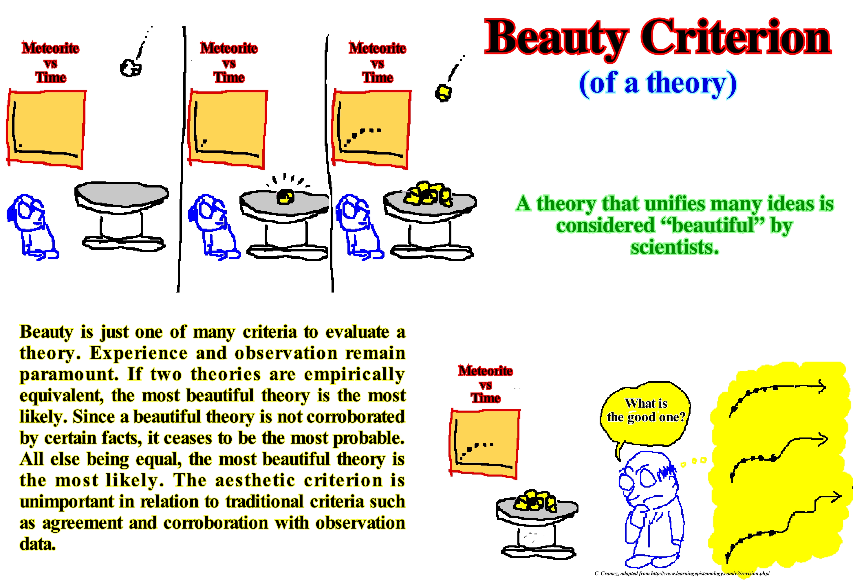
In scientific research, geoscientists face a fundamental problem, that is, describe the world as accurately as possible (do not forget that truth does not exist in science). In order to do so, scientists are required to generalize beyond their experiences (observation data) to clarify any other possible experience. The reason they need to generalize beyond observational data is because there are a very large number of consistent (hard to refute) alternative hypotheses for the same observations data. Although each alternative hypothesis is in agreement with the data observed, they imply different predictions for the data not yet observed. The question is how a scientist and, in particular, a geoscientist should choose the most correct hypothesis among all the alternatives. The first criterion is refutability. The hypothesis that is apparently most easily refuted is certainly the most consistent one. For example, if a geoscientist says: (i) A source-rock is an argilaceous rock ; (ii) A source-rock is a black argilaceous rock ; (iii) A source-rock is a black argilaceous rich in organic matter ; (iv) A source-rock is a black argilaceous rock rich in organic matter deposited in a transgressive interval, it is obvious that hypothesis (iv) is much easier to refute than (i). The second criterion is resistance to refutation tests. The hypothesis that best withstands the refutation tests is, certainly, the most consistent one. The third criterion is Ochkam’s razor or simplicity criterion, i.e., among the various hypotheses that meet the criteria for refutability, the more likely it is the simpler. Due to its qualitative nature, the criterion of beauty is not clearly defined. There is no definition of what beauty means in a scientific theory, yet the more general hypothesis or theory is considered more beautiful.
Bed (Stratum)............................................................................................................................................................................................................................................Couche
Camada / Camada (estrato) / Stratum, Schicht / 层 / Слой (пласт) / Strato, Letto, Fondo /
Horizon or sedimentary interval with a thickness greater than or equal to 1.0 cm. The smallest division of a geological formation defined by bedding planes separating it, below and above, from the underlying and overlying layer. This term, which is, generally, applied to the sedimentary strata, can also be used for volcanic flows or volcanic ash horizons. In the sequential stratigraphy, made from seismic data (seismostratigraphy), the reflectors (chronostratigraphic lines) do not correspond to simple sedimentary layers, but to interfaces between sets of beds with the same physical characteristics (e.g., acoustic impedance).
See: « Aggradation »
&
« Accommodation »
&
« Strata »
As illustrated in these photographs, the sedimentary beds and the bedding planes are obvious in the cliffs forming part of the coast of Portugal, as well as in the hillsides of the Rhone valley, particularly, eastward of the city of Sion in the Loesch region. Sedimentary particles, whether they are clastic or precipitate, are deposited, almost always, in more or less parallel levels called beds or strata. When the thickness of the layers is of the order of centimeters, geoscientists call it a bed. When the layers are very thick, certain geoscientists call them banks. The stratification results from the tendency that water and wind have to spread, over great distances, similar layered sediments, relatively, thin for periods of time with, relatively, analogous environmental conditions. When environmental conditions change at the deposition site, several things can happen: (i) Different sediments may settle down on the top of the previous bed ; (ii) There may be a period during which no sediment is deposited ; (iii) The original bed can be eroded. In all these cases, due to the common depositional environment, the sediments tend to be much more similar within beds than between them. Although sediments tend to be more similar within a bed than between them, lateral continuity has finite boundaries. A particular bed can be thin and pinchout laterally without leaving any record of the deposition time in the area of pinchout. The type of sediment that characterizes a certain level may, laterally, shift to another type within the same bed, which suggests the deposition environment has changed gradually. Certain combinations of depositional environments promote abrupt discontinuities of similar sedimentary horizons. The sands and clay rocks deposited by a river are, sometimes, very discontinuous due to repeated channelling and flooding. Other sedimentary environments induce more continuous beds such as pelagic clayey rocks, in the deepest parts of the basins, i.e., at the base of the continental slope or the abyssal plain. The stratification surfaces represent a relatively small gap. If the gap is larger, the surface corresponds to a unconformity (erosional surface induced by a relative sea level fall that put the sea level below the basin edge). All unconformities have a minimal gap anywhere. The minimum gap is at the base of the continental slope. It is this minimum gap (underlined by the deposit of the submarine basin floor fans) that gives the age of unconformity (fall of the relative sea level, i.e., local sea level referenced to any point of the Earth's surface that can be the sea-floor or the top of continental crust) between two stratigraphic cycles. As illustrated in these photographs, fracture systems, sometimes orthogonal, are visible, often, on the bedding planes. On this subject it is interesting to note in the sixteenth century, Niels Steensen (1669) recognized sedimentary rocks were: (i) Formed of beds or strata ; (ii) Overlapping each other in the order they have accumulated ; (iii) More or less horizontal at the moment of deposition ; (iv) In lateral continuity until pinchout at the edge of the depositional basin. Steno, known as Niels Steensen in the Court of Medicis, advanced these geological conjectures in the book "De solido intra solidum naturaliter contento dissertationis prodromus". He used the bedding to map and interpret the sedimentary rocks. As a result, Jean-Etienne Guettard used the beds, as did Georges Cuvier, in his map of France, and William Smith (1815) when he mapped the sedimentary strata of England on the basis of lithology, erosive ruptures, and sequencing of the fossil content of the beds. Undoubtedly, the recognition of the beds must have had an older origin, since as early as the fifth century BC the contemporaries of Pythagoras were aware of the layered accumulation of the sediments found in the exposed portions of the Earth's crust (Lyell, 1830). McKee and Weir (1953) defined a bed as a three-dimensional rock body, which can be mapped, laterally, of physical, chemical, mineralogical and biological composition, relatively uniform and distinguishable from the rock above and below it. These geoscientists also consider that a 1 cm thick bed is very thin and that a 1 m bed is considered to be very thick, whatever, in seismic lines, only groups of beds may eventually become evident.
Bed Load.......................................................................................................................................................................................Charge basale (Charge de fond)
Carga Sólida de Fundo / Carga de fondo o de base / Sedimentfracht / 床沙 / Расход донных наносов / Carico Basale /
Term describing the largest sediemntary particles (relative to the particles carried by suspension) transported on the bed of a water-stream.
See: « River »
&
« Bypassing »
&
« Point Bar (fossil) »
As illustrated in this photograph, one way to grasp the bed load of a stream is to mark a series of pebbles of various sizes and measure their movement. Generally, downstream, the basal load of a stream is smaller and the pebbles are more rounded than those of the upstream basal load. This is due to the friction and abrasion caused by the sedimentary particles (blocks, pebbles, gravel, sand, etc.) when they collide against each other and against the walls and bed of the channel (where the stream flows), which corrodes the rough textures making them smaller. Selective transport also contributes to the downstream sediment being thinner than upstream. In fact, the larger particles are more, easily, dragged by the current than the smaller particles. Smaller particles are protected by larger ones which require more energy to pull them up and drag them downstream. Relatively large sedimentary particles are transported either by rolling, sliding or by salting at speeds lower than the flow, since they are too large to remain suspended in the stream. Typically, in a water-stream, the bed load represents about 10% of the total amount of sediment transported. Higher values have been found in mountain streams. Erosion caused by a current corresponds to the detachment or removal of rock material from the bed or flanks of the channel where it flows. Approximately 95% of the energy of a current is used to overcome the effects of the friction imposed by the channel and internal molecular friction. This leaves just 5% of the current energy to remove the sedimentary particles from the walls and channel bed. The erosive action of a water-stream takes place in three ways: (i) Dissolution ; (ii) Impact (hydraulic action) at both the margins and the base of the canal, which dislodges the materials and incorporates them into the bed load and (iii) Abrasion, particles that are too heavy to be carried by suspension, roll and jump over the current bed eroding it little by little.
Benguela Current..............................................................................................................................................................Courant de Benguela
Corrente de Benguela / Corriente de Benguela / Benguelastrom / 本格拉洋流 / Бенгельское течение / Corrente di Benguela /
A large ocean current moving northwards formed in the eastern zone of the South Atlantic Ocean Gyre*. This current extends from the Cape of Good Hope to the Benguela region (Angola) around 16° S. It isinduced by southeast wind trade. Trade winds are surface winds that blow, regularly, between subtropical maximum pressure and the equatorial minimum, one in the northern hemisphere (north-east trade), the other in the southern hemisphere (south-west trade).
See: « Ocean Current »
(*) In oceanography, a gyre is any large system of circulating ocean currents, particularly those involved with large wind movements. Gyres are caused by the Coriolis effect ; planetary vorticity along with horizontal and vertical friction, determine the circulation patterns from the wind stress curl (https://en.wikipedia.org/wiki/Ocean_gyre).
Benthonic (Benthic, organism)..................................................................................................................................Benthonique (Organisme)
Bentónico / Bentónico (organismo) / Benthontischen / 湖底的 / Придонный (организм) / Bentonici /
Aquatic organism that lives on or within the sediments of the bottom of a water-body, usually, the sea. It is why the sea-floor is, sometimes, called the benthonic domain.
See: « Pelagic (organism) »
&
« Benthos »
&
« Depositional Environment »
Since the 1970s, marine ecology students at Moss Landing Marine Laboratories have participated in several cruises to study fish and invertebrates from the deep environments of Monterey Bay (USA). The photograph (Griffiths), in centre, is part of one of the samplings of the benthic organisms studied by them. The other, illustrates the surface of a limestone with trilobites, brachiopods, rough and tabulated corals, gastropods, etc. of the Jupiter Formation (Lower Silurian), Anticosti Island, Quebec, Canada (Axel Munnecke, Universität Erlangen-Nürnberg). In hydrocarbon research, the most studied and most useful benthic are by far the foraminifera. In fact, foraminifera, found in all marine environments, may be planktonic or benthic. They belong to the order Foraminiferida (in an informal way called foraminifera). This order forms part of the Protista kingdom, sub-kingdom Protozoa, phylum Sarcomastiphora, sub-phylum Sacrodina, superclass Rhizopoda and class Granuloreticulose. Foraminifera have a shell and are unicellular animals devoid of tissues and organs, but have granuloreticulosis (ectoplasm fibbers that include many grains and fine particles of various materials). The foraminifera have a very large geological distribution (from the Cambrian to the Present). The first forms appearing in the fossil record (Allogromycin) have organic shells or are simply agglutinated tubes (agglutinated refers to shells formed by the agglutination of foreign particles bonded by a variety of cements). The foraminifera with hard shells are rare until the Devonian, a geological period in which the fusulinids began to develop and whose apogee occurred in the Carboniferous and Permian before disappearing completely at the end of the Paleozoic. The first forms are benthic. The planktonic forms, which derive in the upper part of the water bodies, only appear in the fossil record from the Middle Jurassic (on the north shore of the Tethys Sea* and epicontinental basins of Europe). They were, probably, mero-planktonic forms, that is, planktonic, only, during the last stages of the cycles of their lives.
(*) Sea, between the NE of the small supercontinent Gondwana and SE of the small supercontinent Laurasia, which replaced the Paleotethys ocean (formerly the Sea of Tethys of Suess, i.e., the Paleozoic Ocean, between Gondwana, Central Europe, Iberia, China and Central Asia). The Tethys Sea began to form in the south of the Paleo-Tethys since the Cimmerian plate was individualized (Permian / Triassic). The expansion of the Tethys Sea forced the Cimmerian plate to collide with the Laurasia, to finally the Sea Tethys completely replace the Paleo-Tethys.
Benthos............................................................................................................................................................................................................................................Benthos
Bentos / Bentos / Benthos / 底栖生物 / Бентос (донные организмы) / Benthos /
Plants and animals found in the sediments of the sea-floor, lake or any other water-body, regardless of depth. Certain geoscientists consider three types of benthos: (i) Epibenthos, that is, free forms; (ii) Fixed epibenthos (to the substratum) and (iii) Endobenthos, i.e., necrophagous (eat dead or decaying animal flesh) or detritivorous organisms (feed on detritus ; saprophagous). Synonym of Benthic.
See: « Pelagic (organism) »
&
« Fossil »
&
« Benthonic (organism) »
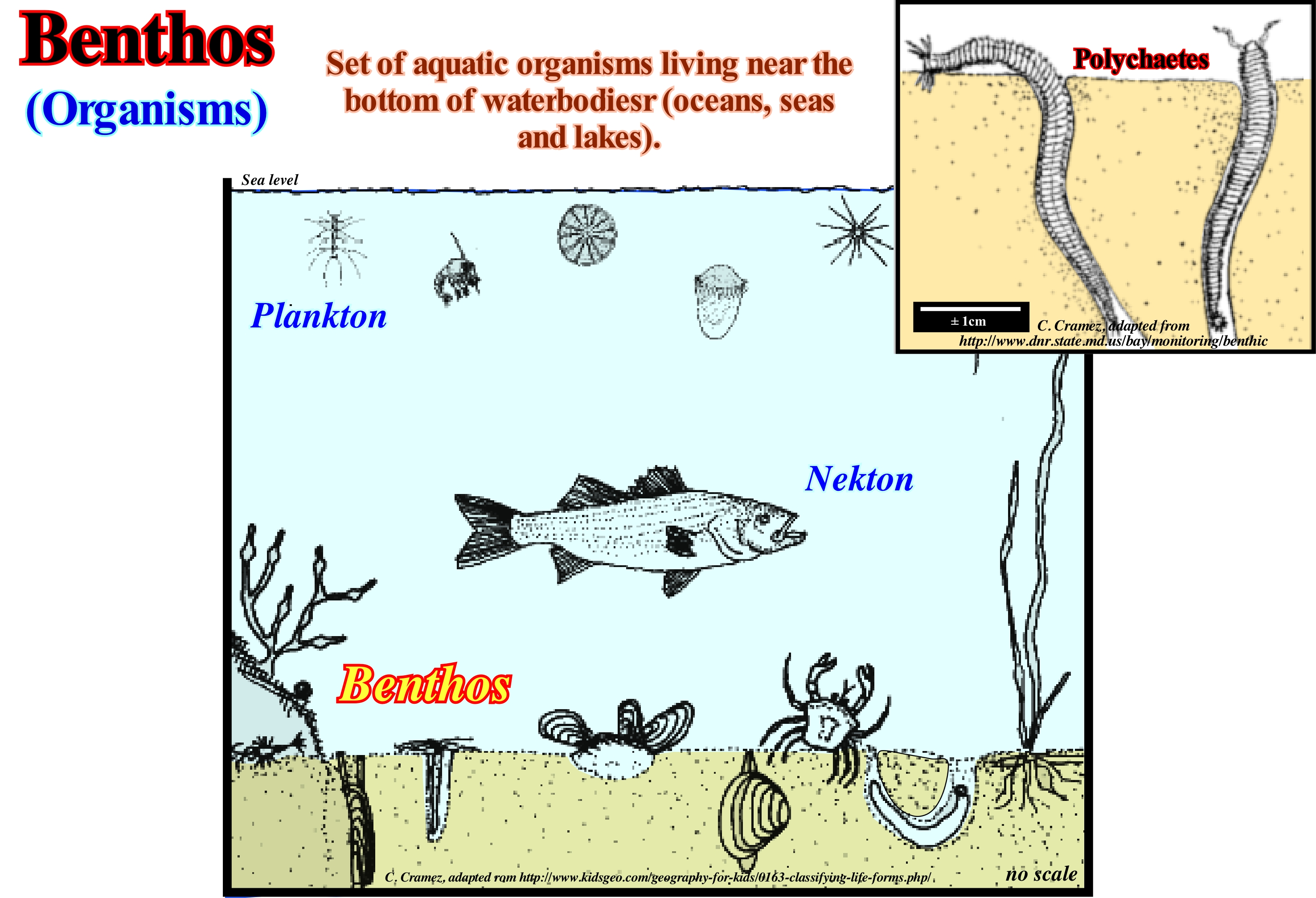
In this figure are schematised the environments of plankton, nekton and benthos, which live on the sea-floor or are slightly buried. The polychaetes (class of animals of the phylum annelids) shown at the top right, are benthic animals. They live on the bottom of the sea or within the sediments that form the bottom of the sea. Taking into account the type, location and size, various categories of benthos may be considered. Taking into account the type they may be: (i) Zoobenthos (benthos) or (ii) Phytobenthos (autotrophic organisms, such as algae and rooted aquatic plants). Taking into account the location, they can be: (a) Epibenthos, when they live inside the sediments, but near the top and (b) Hyperbenthos (when they live on the sediments). Considering the size, the benthos may be: (1) Macrobenthos, when the size is greater than 1 mm (such as polychaete worms, pelecypods, anthozoans, echinoderms, sponges, ascidians, crustaceans, etc.) ; (2) Middlebenthos where the size varies between 1 mm and 32 μm (such as pelecypods, copepods, ostracods, cumaceans, nematodes, turbinates, foraminifera, etc.) and (3) Microbenthos when the size is less than 32 μm (bacteria, diatoms, eyelashes or pseudopodia, amoebae, flagellates, etc.). The main food of the benthos is the plankton and organic matter coming from the continent. The depth, temperature, salinity of the water and the composition of the substratum (sea-floor) control the occurrence of benthos. Near the coast and in places where sunlight penetrates to the bottom of the sea, benthos capable of making photosynthesis* are preponderant. Sponges and pelecypods are very abundant when the bottom of the sea is hard and sandy, while the geophagous (which eat sediment) prefer the substrates inconsistent. Fish, starfish, cephalopods and crustaceans are important predators and scavengers (which feed on dead organic matter).
(*) Fixation of carbon by green plants under the action of sunlight. The light energy is converted into chemical energy and stored in the form of sugar. Photosynthesis occurs in plants and some algae (Protista Kingdom). Green plants need only the energy of light, CO2 and H2O to make sugar. Photosynthesis occurs in chloroplasts, specifically through chlorophyll.
Bergschrund (Glacier).....................................................................................................................................................................................Rimaye (Glacier)
Fissura de Despegamento (de glaciar)/ Rimaya, Rimaye / Bergschrund / Bergschrund(从德国 裂山 )/ Присклонная трещина (ледника) / Crepaccia terminale /
Fissure between the snow field (firn) and the rocky wall that formed in a glacial cirque, when the glacier begins to move from the rocky wall in its downstream movement. Certain geocientists use the term bergschrund to designat the detachment crevice, which separates the part of the glacier that is in motion from the part of the glacier that, upstream, is more stationary or that does not flow downslope.
See: « Glacier »
&
« Ablation »
&
« Crevasse »
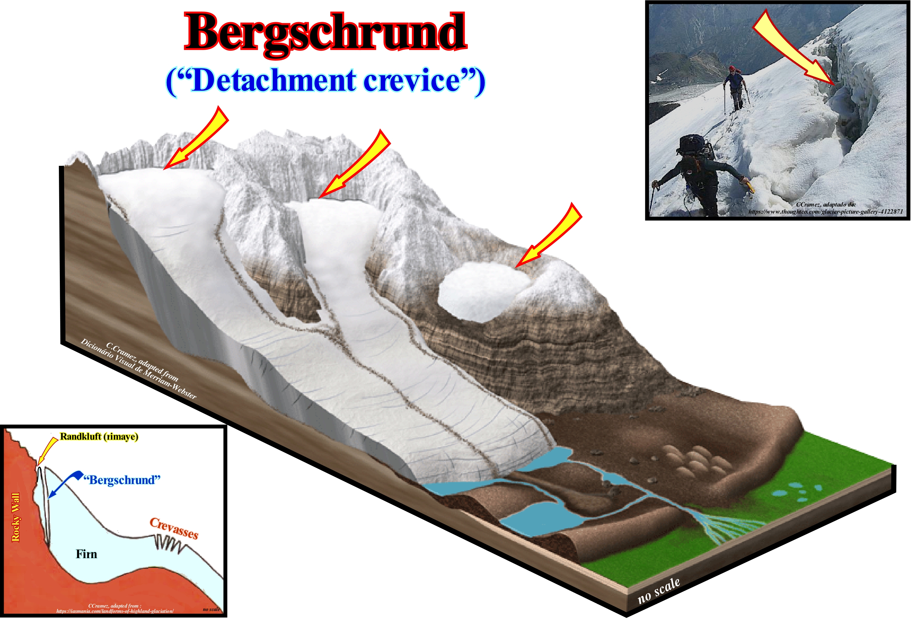
In this figure, bergschrunds, i.e., glacial cirque detachment crevices are obvious. They separate the ice from the rock wall, which is, often, almost vertical. Many geoscientists consider bergschrund of a glacial cirque the fissure that is more upstream of the glacier. The cracks on the sides of a glacial cirque, which they consider as the result of a partial melting of the ice due to the heat of the rock, are called "randkluft" (edge cracks). The bergschrund is distinct from the randkluft (also called rimaye), which is the crevasse of which one face is the rock, back wall of the corrie* or cirque. The randkluft arises, in part, from the melting of the ice arising from the presence of the warmer rock face. However, the randkluft is sometimes called a bergschrund. Outside the glacial cirque, the cracks or crevasses separating that part of the glacier that is moving from the part that is stagnant and which can extend to the rocky substratum (sometimes more than 100 m deep) are referred to as detachment cracks of a glacier. Do not confuse these cracks with transverse cracks, which form in the extension or enlargement zone or with marginal cracks, which are diagonally oriented (the glacier speed is higher in the central part than in the margins) or even with the longitudinal fissures, that form, parallel, to the movement of the glacier when the width of the glacier is in expansion. To avoid mistakes, it is preferable to always use the term bergschrund just for the glacial cirque detachment crevices and fissures or detachment cracks for the other, in particular, for those outside of the glacial cirque. The former are, relatively,. non-dangerous, but the latter are extremely dangerous, because during the winter they are covered with snow and sometimes partially filled with snow. The snow cover forms a bridge between the ice blocks, which climbers use in summer to move from one block to the other. The judgement of snow bridge strength as well as the assessment of fissure filling by snow is essential for the safety of climbers, who are usually perfectly able to distinguish dangerous bridges from safe bridges. The problem exists especially when tourists venture alone on the mountain and glaciers not to mention young people, who in summer will, without authorization and without a guide, ski and surf in the ice.
(*) Steep-walled semi-circular depression in a mountain.
Beringia (Würm glaciation)...........................................................................................................................................................................................Béringie
Beríngia / Beríngia / Beringia / 白令海峡 / Берингия / Beringia /
Region between Siberia and Alaska, roughly, defined by the Bering Strait, Chukchi Sea and Bering Sea. Beringia was exhumed during the Würm glaciation, particularly, between 50,000 and 40,000 years ago and, again, between 25,000 and 12,000 Ma.
See: " Würm (glaciation)"
Berm.....................................................................................................................................................................................................Berme, Gradin de plage
Patamar de praia / Terraza de la playa / Stuffe / 小平台(海滩),步海滩 / Уступ (надводная береговая терраса) / Ripida spiaggia /
The more or less horizontal part of a beach step, formed on the foreshore by the action of the waves. The inflection line between the berm and the abrupt of each beach step, is sometimes called crest of the berm or platform. In the field, the berms give important indications about sea level changes. They are not recognized on seismic lines. Their dimensions are lower than the seismic resolution. Synonym of Beach Berm.
See: «Berm (beach berm) »
Berm (Beach-step)........................................................................................................................................................................Berme, Gradin de plage
Degrau de Praia (escarpa de praia) / Terraza de la playa / Stuffe / 比亚陡峭 / Уступ (надводная береговая терраса) / Ripida spiaggia /
Name given, in general, to the platform (the more or less horizontal part) of a beach-step or beach escarpment. It is formed on the upper part of the foreshore by the action of the waves.
See: « Beach »
&
« Delta »
&
« Surf Zone »
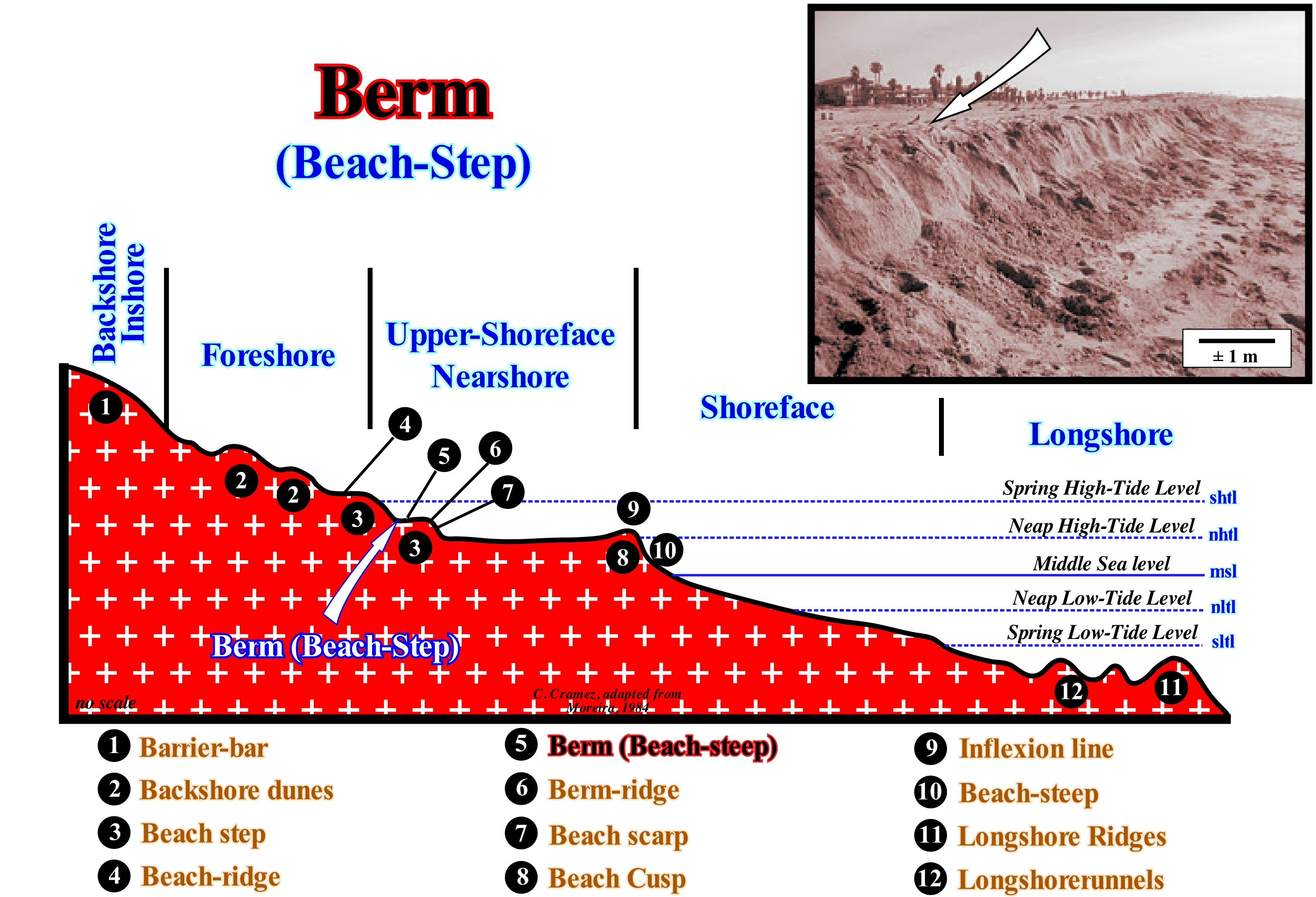
When the surface of the upper shoreface is reached by the waves (during the high-tide periods), it is modelled on terraces called berms or beach-steps (3), which are formed by a platform or beach-berm (5) and an abrupt (7). The inflection line between the beach-berm and the abrupt of each steep is the berm-ridge (6). The highest berm-ridge is the high beach-ridge (4). The beach-steps (nearshore) are, in general, smaller than the resolution of conventional seismic lines. On high-resolution seismic lines, beach-steps may be visible, but should not be interpreted as the backstepping of depositional coastal break (depositional surface), as is, often, the case. During a transgressive interval (retrogradational geometry), at each relative sea level rise, the depositional coastal break is displaced continentward (function of the lower unconformity morphology of the associated sequence-cycle) moving further away from the new basin edge increasing the extension of the newly formed continental shelf and the water-depth. It may be said the successive retrogradations of depositional coastal break are induced by relative sea level rises, whereas the formation of beach-berms on the nearshore are created by the erosive action of the waves during the high-tide periods. Likewise, the beach-step that some geoscientists call the berm platform, due to its, more or less, horizontal geometry, should not be confused (in the field and on seismic lines) with a ravinment surface, which is produced by the erosive action of the base-level of the sea, at the time of a rise in relative sea level, i.e., during a flooding of the coastal plain. In the sketch illustrated above, it is interesting to note that what certain geoscientists, generally, call the coastal environment (characterized by a water-depth lower than the neritic environment) corresponds to the set of the nearshore and the shoreface since it encompasses the intra-tidal zone, i.e., the zone bounded between the high-tide and low-tide levels.
Berm (Platform, landing)......................................................................................................................................................Berme, Gradin de plage
Berma de Praia (plataforma) / Terraza de la playa / Stuffe / 比亚陡峭 / Уступ (надводная береговая терраса) / Ripida spiaggia /
Landing or platform (the part, more or less, horizontal) of a beach-step, formed on the foreshore by the action of the waves. The line of inflection, between the berm and the abrupt of each beach-step is, sometimes, called berm-ridge. In spite of te fact that their dimensions are under the seismic resolution, in the field they give important suggestions on the relative sea level changes.
See: « Beach »
&
« Delta »
&
« Surf Zone »
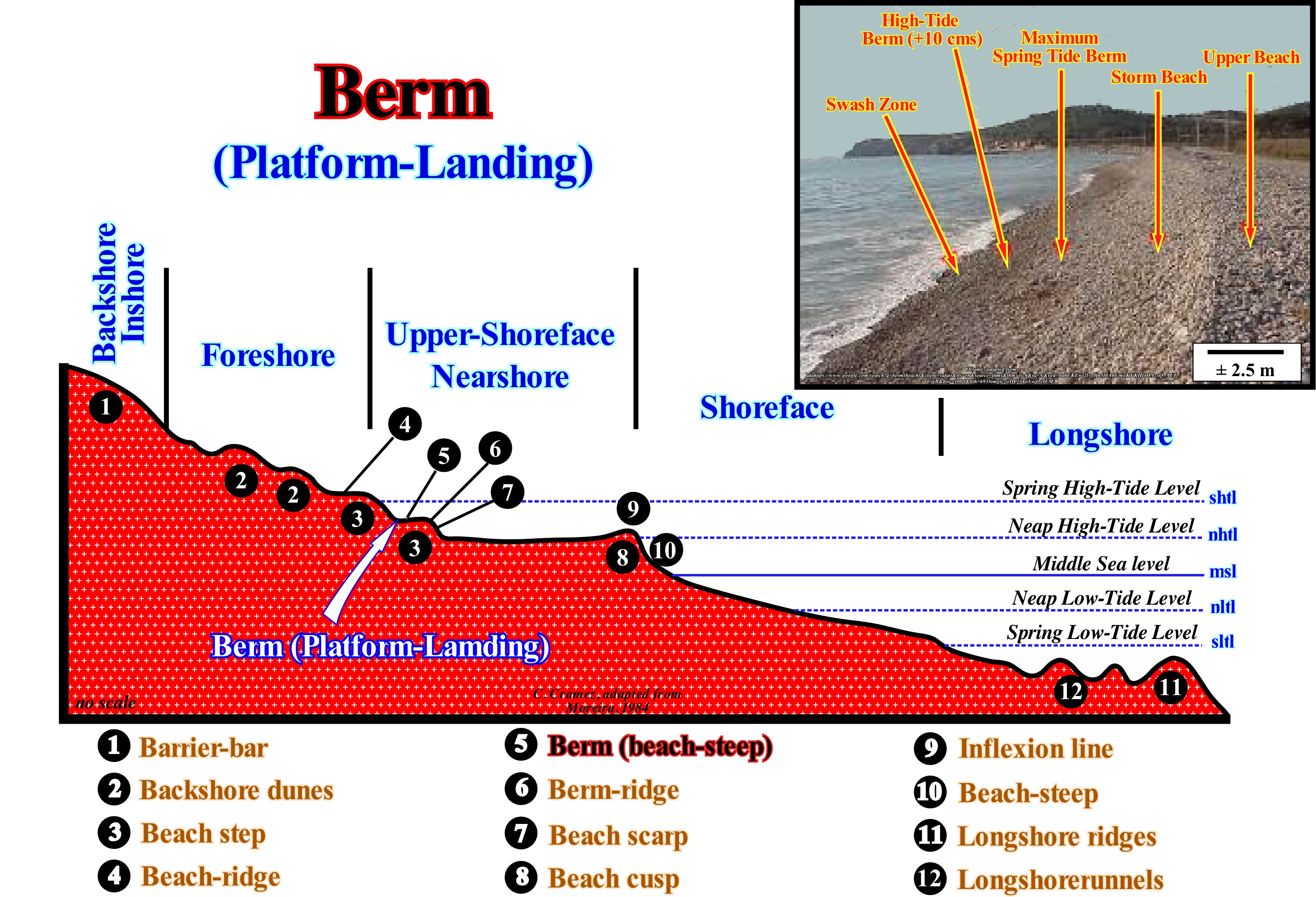
When the surface of the nearshore is reached by the waves (during the high-tide periods), it is modelled on terraces called beach-steps (3), which are formed by a landing or platform (berm) of the beach (5) and an abrupt (7). The line of inflection between the berm and the abrupt of each-step is the berm-ridge (6). The highest berm-ridge is the crest of the foreshore (4). The beach-steps (nearshore) are, in general, smaller than the resolution of conventional seismic lines (possibility of separating two events that are very close). However, in high resolution seismic lines, the beach-steps may be visible, but should not be interpreted as retrogradations of the depositional coastal break as is, often, the case. In a sequence-cycle, induced by a 3rd order eustatic cycle whose duration varies between 0.5 My and 3-5 My, during transgressive interval (TI), i.e., the lower sub-group of the highstand systems tracts group(GHST), whose overall geometry is retrogradational. At each rise of the relative sea level* (eustatic paracycle), the depositional coastal break of the depositional surface (more or less the shoreline) is displaced continentward. The first upstream displacement of the shoreline, whose amplitude is function of the morphology of the lower sequence-cycle boundary unconformity and the amplitude of the marine ingression, creates a water-depth and a shelf (continental platform). The following retrogradations of the depositional coastal break occurring after the deposition of each sequence-paracycle (during the stability period of relative sea level that follows each marine ingression) are caused by increasingly important marine ingressions (relative sea level rises in acceleration). On the seismic lines, the bathymetric anomalies created by the successive retrogradations of the coast line have nothing to do with the topographic anomalies of the abrupt and beach-berms, neither with respect to dimensions or with regard to genesis. The formation of beach-berms (nearshore) is not associated with in relative sea level changes, but with the erosive action of waves during the high-tide periods. In this sketch, the beach-step (3) that some geoscientists call platform, due to its, more or less, horizontal geometry, should not be confused (in the field or on seismic lines) with a ravinment surface, which is produced by the erosive action of the base level of the sea, during a relative sea level rise, that is, during the flooding of the coastal plain. What certain geoscientists call, generally, the coastal environment (characterized by a water-depth lower than the neritic environment) corresponds to the set of the nearshore and the foreshore, since it encompasses the intratidal zone, i.e., the limited zone between high and low-tide levels. The different levels of the sea can be deduced from the morphology of the beach (lato sensu). Spring high-tide level corresponds, more or less, to the limit between the nearshore and the foreshore (the spring tides occurring near the equinoxes with maximum amplitude are the equinoctial tides). The level of the low-tide (empty tide) corresponds to the upper limit of the longshore ridges and longshorerunnels, while the beach-steep (10, in this figure) or the last beach-step, is the boundary between the foreshore and the nearshore and underlines the level of neap high-tide (New Moon) at the top, and, more or less, the middle sea level at the base. In the classification of the landforms of a beach here adopted of from continent seaward one can recognise: a) Backshore, for the form of relief that constitutes the inner limit of the beach, which can be a cliff or a barrier-bar ; b) Foreshore, to the top of the beach with a steep slope only reached in the spring high-tides and storms ; c) Nearshore, for the part of the beach that extends in the space reached by the swash currents (the uprush current and the backwash) between the levels of neap high-tide and low-tide ; d) Shoreface, to the lower part of the strand, which comprises the space that extends between the limits reached by the spring and neap low-tide and e) Longshore, to the part of the beach always submerged that extends from the limit of the lower tides (corresponds to the surf zone of certain geoscientists).
(*) It is important not to confuse relative sea level with absolute sea level. The former is local and referenced to any point on the Earth's surface which may be the top of the continental crust (usually, the base of the sediments) or the sea-floor. The second, which many geoscientists call eustatic or global sea level, is supposed to be referenced to the Earth’s centre . The relative sea level is a combined action of the absolute sea level and tectonic (uplift or subsidence of the sea-floor).
Berm (Beach-berm)....................................................................................................................................................................Berme, Gradin de plage
Degrau de Praia / Terraza de la playa / Stuffe / 比亚陡峭 / Уступ (надводная береговая терраса) / Ripida spiaggia /
Step composed by a landing (platform) and a steep formed by the action of the sea-waves in the foreshore. The line of inflection between the berm (platorm) and the steep is called the berm-ridge.
See: « Beach »
&
« Delta »
&
« Surf Zone »
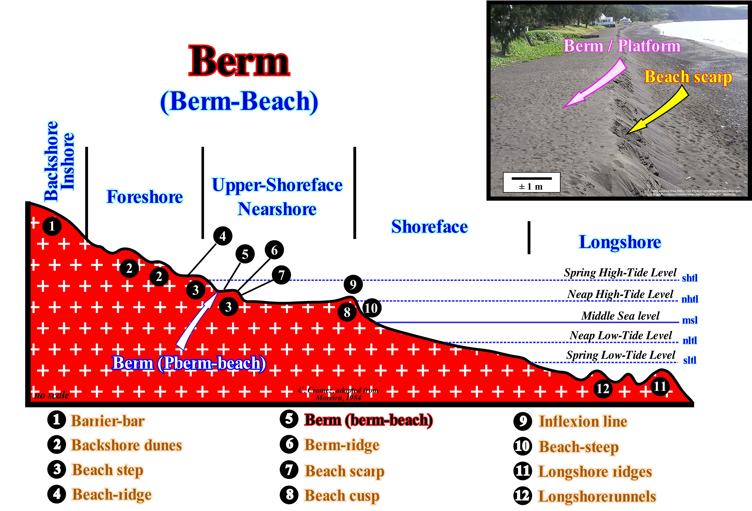
The different levels of the sea can be deduced from the beach morphology. The level of high-tide corresponds, more or less, to the limit between the nearshore and the foreshore (the tides occurring near the equinoxes, have the maximum amplitude, are the equinoctial tides). The level of the low-tide (empty tide) corresponds to the upper limit of the longshore ridges and the longshorerunnels, while the beach-scarp (the last step of the beach), the boundary between the shoreface and the nearshore, underlines the level of neap high-tide (New Moon), at the top, and, more or less, the middle sea level at the bottom. When the surface of the nearshore is reached by the waves (during the spring high-tide periods), it is modelled on terraces called beach-steps (3), which are formed by a landing or berm of the beach (5) and an abrupt (7). The inflection line between the berm and the berm-steep of each step is the berm-ridge (6). The highest berm-ridge is the high beach-ridge (4). The beach-steps (nearshore) are, in general, under the resolution of conventional seismic lines. In high resolution seismic lines, beach-steps may be visible, but they should not be interpreted as retrogradations of depositional coastal break of the depositional surface (more or less the shoreline), as is, often, the case. Within a sequence-cycle, during a transgressive interval (retrogradational geometry), at each relative sea level rise*, the depositional coastal break is displaced upstream (function of the morphology of the lower unconformity of the associated sequence-cycle) moving further away from the new basin edge, i.e., increasing the extension of the newly formed shelf and, in the same way, increasing the water-depth. It can be said that the successive retrogradations of the depositional coastal break of the depositional surface are induced by relative sea level rises, whereas the formation of the nearshore berms are created by the erosive action of the waves during the spring high-tide periods. Berm-steps, which some geoscientists call the platforms, due to its, more or less, horizontal geometry, should not be confused (in the field or on seismic lines) with ravinment surfaces, which are produced by erosive action of the base level of the sea, during relative sea level rises, i.e., during flooding of the coastal plain. The beach-ridge underlines the spring high-tide (occurs during the syzygies, i.e., when the lunar and solar effects act together, reinforcing each other, producing the highest high-tides and the smallest low-tides). The inflection line marks the level of neap high-tide and the base of the escarpment of the beach at the middle sea level. The boundary between the longshore and the shoreface underlines the neap low-tide. The cliffs are formed when destructive waves attack the base of the rock between the high-tide and low-tide marks. By several erosive processes, the waves attack the base of the frontal surface of the cliff forming an undercutting. The continuity of the wave action increases the dimensions of the undercutting until the weight of the overhanging surface (cornice) is sufficient to fall. Since the waves remove the rock debris from the collapse, they begin, again, to attack the base of the cliff. The erosion of the waves, followed by the collapse of the cliff, happens, continuously, reason why the coastline recedes towards the continent. The beach-ridge underlines the spring high-tide. The inflection line marks the level of neap high-tide and the base of the escarpment of the beach the middle sea level**. The boundary between the longshore and the shoreface emphasizes the level of neap low-tide. The salt-spray (sea-spray) zone (upper littoral, above high-tide level) is the highest part of the inter-tidal zone. It has little water, just salt-spray. The high-tide zone (upper middle littoral zone) is only flooded during high-tide. The major organisms in this area are anemones, barnacles, star-legged, crabs, green algae, crustaceans, etc. and has little marine vegetation. The lower zone of the strand (intertidal zone or lower littoral) is, usually, covered by water and is only dry during extreme low-tides. When the exposure to the air is long, many of the organisms living in this zone die.
(*) Local sea level referenced to any point on the Earth's surface which may be the top of the continental crust (base of the sediments) or the sea-floor, which is the result of the combined action of the tectonics and the absolute or eustatic sea level, supposed to be global and referenced to the Earth's centre.
(**) Average height of the ocean surface (as the mid-point between mean high tide and mean low tide), used as standard in the terrain elevation calculation. To determine the mean sea level, the best thing to do is to choose a place and calculate the average level at that point and use it as a reference point. Generally, from hourly observations made over a relatively important period (plus or minus 30 years), it can be calculated to be the mean for that measurement point.
Berm-Ridge (Storm beach)....................................................................................................................................................................Crête de plage
Crista da Praia / Cresta de la playa / Strandwälle / 滩脊 / Гребень косы (береговой вал) / Spiaggia cresta /
The highest berm-ridge in the backshore-inshore (updip limit of the berm). It resembles to a small terrace with a low slope looking seaward.
See: « Beach »
&
« Delta »
&
« Surf Zone »
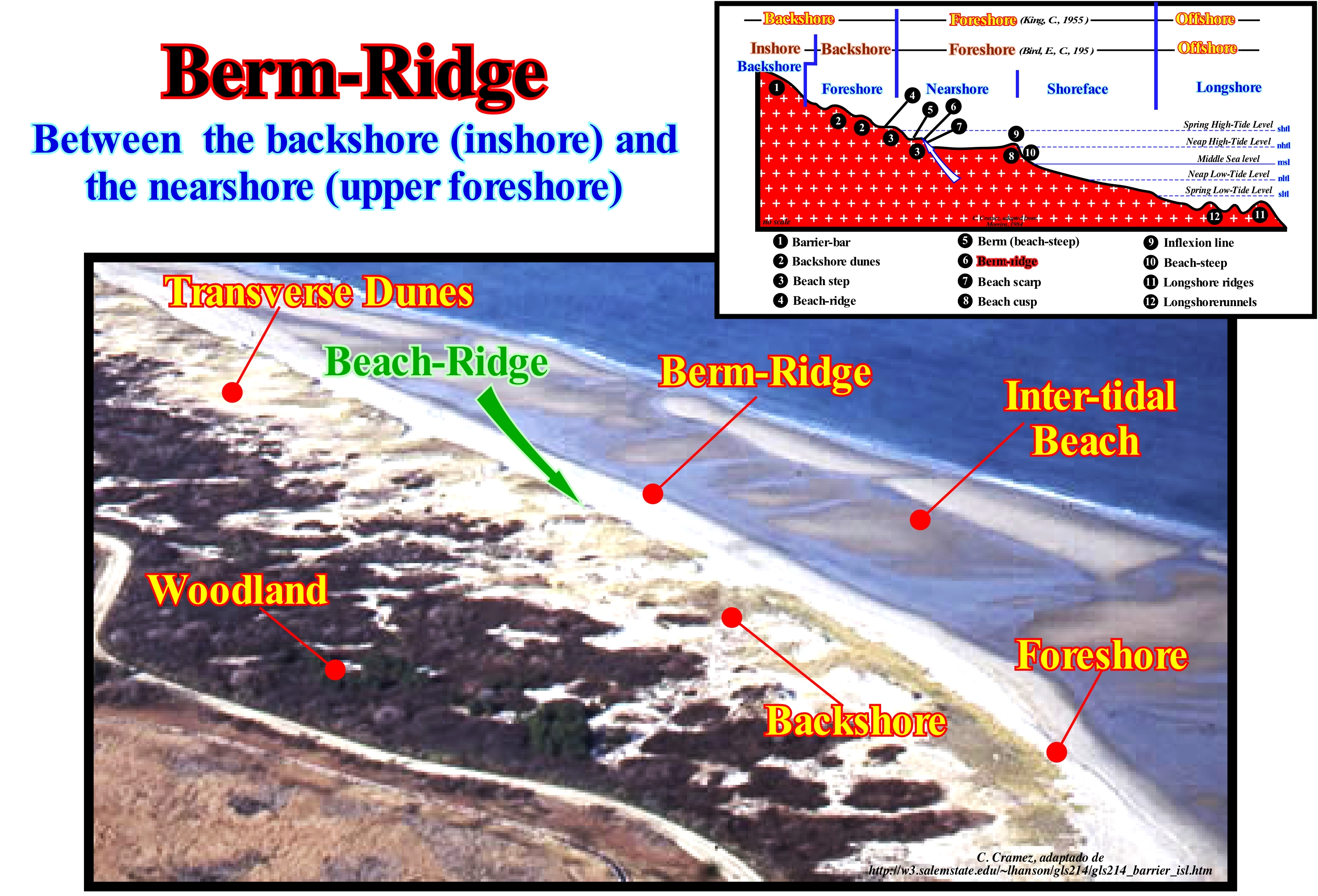
In this aerial photograph of Plum Island (USA), taken during low-tide, a barrier-bar or strand or barrier beach is easily recognized, that is, an sand island elongated and, more or less, parallel at the coast of which it is separated by a swamp (bays or lagoons exist, sometimes, between the coast and the barrier-bars). In this particular case, from downstream to upstream, we can easily distinguish: (a) Intra-tidal beach, which includes the longshore*, shoreface and nearshore; (b) Foreshore ; (c) Backshore ; (d) Transverse dunes (dunes, whose direction is, more or less, perpendicular to the coastline) ; (e) Vegetation of the overbanking zone. The beach-ridge indicated in this figure corresponds to the line of inflection between the last step and the last berm of the beach. In reality, in the foreshore, the surface reached by the waves is modelled in steps, called berm steps of the beach, which are formed by a landing (platform) or berm and an abrupt. The line of inflection between the berm and the abrupt of each step is called the berm-ridge. The crest of the highest berm is the beach-ridge. The lower berm-step marks the boundary between the nearshore and the foreshore. A barrier-bar can have a length between 3 and 100 km and its width can reach 3 km. Normally, the barrier-bars form in chains, in which each (barrier island) is separated from the others by an inlet (also called entrance). The number of inlets in a chain of barrier-bars is a function of wave and tidal energy. Very high waves, i.e., with a lot of energy tend to close the inlets, whereas the tidal flow tends to open the inlets. The width of a barrier-bar reflects, fundamentally, the terrigeneous influx and the changes of relative sea level. A relative sea level rise (ingression) causes erosion and an continentward displacement (retrogradation) of the barrier-bar, that is, a transgression. However, if the terrigeneous influx is very strong, even with a significant relative sea level rise, the barrier-bar can prograde towards the sea, which means that a regression can develop.
(*) As illustrated in the sketch on the right corner of this figure, the definition of the coastal terms varies with the geoscientists. Consequently, to avoid misunderstanding a small glossary of the used terms is, always, welcome.
Bernouilli Effect...............................................................................................................................................................................Effet de Bernoulli
Efeito de Bernoulli / Efecto Bernoulli / Bernoulli-Effekt / 伯努利的效果 / Эффект Бернулли / Effetto di Bernoulli /
The faster a fluid flows, the lower its pressure. The Bernoulli effect is what allows birds and air-planes to fly. The wings, whether natural or artificial, have a very particular geometry. It is the shape of the wings that creates a significative difference in the flow of air along the upper and lower surfaces, which produces the uplift.
See: « Flux »
&
« Laminar Flow »
&
« Turbiditic Flow »
As illustrated in this figure, the basic idea of Bernoulli's effect on the wings of an aeroplane is as follows: (i) The air stream is divided into two parts when it encounters the front edges of the wings ; (ii) One goes up the top surface and one down the bottom surface of each wing. In order for the currents to be at the same time at the end of the opposing distal edges of the wings, the upper airflow must move faster than the lower current, since the distance to be travelled is greater. Combining Newton's laws of motion* and the energy conservation law**, D. Bernoulli has shown that the pressure exerted by a fluid, which may be a liquid or a gas, decreases as the velocity of the fluid increases. Due to this effect, the vertical upward pressure of the air currents moving under the wings of an aeroplane is greater than the vertical downward pressure exerted by the air currents moving above the wings. That means that once an aeroplane gains speed, the pressure difference exerted by the air currents on the wings of the aeroplane increases, which creates a vertical upward force (detachment force). When the pressure difference is large enough, the detachment force becomes greater than the force of gravity (vertical downward), which forces the aircraft to take off. It is the lifting force that keeps the aeroplane in the air throughout the flight. When a plane takes off at an airport, it takes off in different directions on different days. He does the same when he lands. The direction of take-off depends on the direction of the wind. The aeroplane takes off more easily, against the wind than in the wind. It is also the effect of Bernoulli that increases the flames of a stove, towards the chimney, when a gust of wind passes over the top of the chimney, since the speed of the wind on the chimney decreases the pressure of the air facilitating the vertical movement of the flames.
(*) Newton's three laws summarize movement in space: (i) A body moves in a uniform rectilinear motion if it is not subjected to any force, (ii) The acceleration of a body is proportional to the force applied and (iii) Each action is opposed by an equal reaction.
(**) In classic physics, the Thermodynamics, i.e, how heat moves, is governed by three laws. The first law or law of energy conservation says that whatever happens, the energy of the Universe is constant (we can not create or destroy energy, but only change one form of energy in another). The second law says that entropy (the measure of the part of the energy that can not be exploited in any way) of an isolated system always increases. The third law says that when the temperature of a system reaches absolute zero (-273.15° C) all natural processes cease to occur and entropy reaches its minimum.
Bifurcation Point................................................................................................................................................................................................Apex (Du delta)
Ápice do Delta / Punto de bifurcación, Ápice del delta / Delta Scheitel, Delta Spitze / 顶点的三角洲 / Вершина дельты (точка ветвления) / Apice del delta (punto di biforcazione) /
Diffluence point of the fluvial channel located more upstream. It marks the upper limit of the delta (usually, up to where the high-tide enters).
See: « Delta »
&
« Highstand »
&
« Highstand Systems Tract »
The deltas are formed by the accumulation of allochthonous sediments in the mouths of the fluvial currents, both in the lakes and in the sea, promoting, in the latter case, the progradation (seaward displacement) of the shoreline. Sedimentary accumulation occurs both above and below sea level, when it is faster than sediment removal by coastal sediment transport processes. In this figure, the bifurcation point of the Zambeze River delta (Mozambique) is easily recognized, both in satellite photography and in the delta sketch, in which are mapped: (i) Upper Delta Plain ; (ii) Lower Delta Plain and (iii) A portion of the abandoned delta. A delta is a sedimentary systems tract, i.e., a lateral association of different synchronous and genetically bound depositional systems*, which can be deposited, within a sequence-cycle, either under lowstand geological conditions, in a lowstand prograding wedge (LPW) or in highstand geological conditions, usually in the highstand prograding wedge (HPW) but, sometimes, also in the transgressive interval (TI). In general, a delta is formed by a lateral association of contemporary depositional systems, which characterize: 1) The upper sub-horizontal delta layers (upper beds, topset beds) ; 2) The inclined seaward delta layers (inclined beds, foreset beds) and 3) The lower sub-horizontal delta layers (lower beds, bottomset beds). The former are formed by sands, siltstones and shales of the deltaic plain, which, as in the case of the Zambeze delta, can be deposited either on the upper (more fluvial) delta or on the lower (more estuarine) delta and the delta front sands. The delta front is a site of intense deposition where the delta morphology is, actually, established and where the coarsest sediments are deposited in bars in front of the distributive channels, whose morphology depends on: (a) Flow energy and (b) Density difference between river water and water. The delta layers inclined seaward are formed by prodelta shales, which are located below the action level (erosion) of the waves and where fine sedimentation predominates (silts and clays). In the lower sub-horizontal delta layers, which sometimes deposit at the base of the prodelta, it is possible to recognize turbidite depositional systems of sandy facies (proximal turbidites of the Shell's geoscientists) associated with delta front failures and landslides. The facies of the delta plain are, mainly, silty, while the delta front is, generally, sandy and that of the prodelta clayey. The chronostratigraphic lines of the delta plain and delta front, i.e., the depositional surfaces, are practically horizontal (upper beds), while those of the prodelta are inclined to the seaward (foreset beds). In the distal part of the prodelta, sub-horizontal intervals known as sub-horizontal lower layers may be deposited in continuity, which have, generally, a clayey facies. However, sometimes in the lower layers, that is, in the most distal and lowest part of the prodelta, are small sand lobes of turbiditic origin, which, as stated above, certain geoscientists have called proximal turbidites. As a delta progrades, the angle of the delta slope, i.e., more or less, the slope of the prodelta increases and can reach a critical angle (which varies with the water-depth), from which all the delta front progradation is impossible. If the critical angle is reached, the delta front collapses and creates small turbiditic currents transporting the sedimentary particles downward to the distal and deep part of the prodelta. When the currents decelerate, at the base of the delta slope, the sedimentary particles that they transport deposit themselves forming small lobes or turbiditic fan. Aggradation allows progradation, once in the field or on seismic lines, in continuity of sedimentation, over an aggradational interval there is, almost always, a progradational interval which has been deposited upstream of a deep aggradational interval and downstream of a shallow water aggradational interval (Johannes Walther's facies rule or simply Walther's law, which Armanz Gressly had already fully understood).
(*) Each depositional system is characterized by a particular facies, in general, a lithology and associated fauna. Armanz Gressly not only recognized the sedimentological and paleontological characteristics of the rocks, which he termed "facies", reflected the deposition processes in specific geomorphic environments, but he also understood facies occur independently of time, and time and rocks should be treated with separate concepts and vocabularies. He also suggested there are predictable patterns of relationships between facies.
Big Bang (Theory)..................................................................................................................................................................................................................Big Bang
Big Bang / Big Bang / Big Bang (Theorie) / 宇宙大爆炸(理论) / Большого Взрыва (теория) / Big Bang (teoria) /
Cosmological model used by geoscientists to describe the origin and evolution of the Universe. The term Big Bang is associated with all the theories describing our Universe as the result of a rapid expansion that makes one think of an explosion. The Big Bang is associated with a dense and hot time that the Universe knew about 14 billion years ago.
See: « Big Crunch (Theory) »
&
« Cryptozoic »
&
« Cosmologic Time »
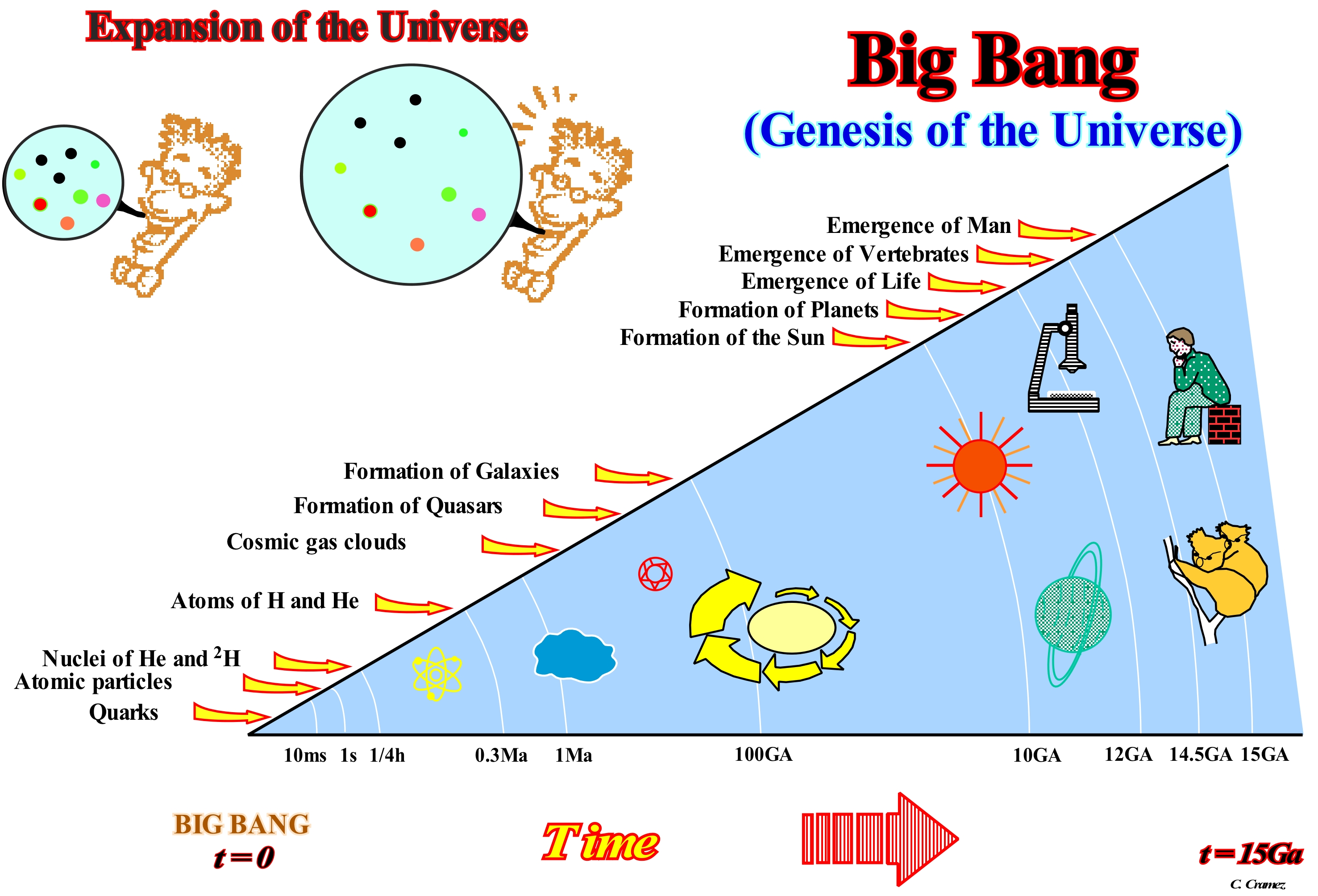
The Big Bang is the cosmological theory according to which the primordial Universe, extremely hot and dense, would have begun its existence by an enormous "explosion" that would be produced in every point of the space to about 15 Ga. The term Big Bang was invented by a proponent of a competing theory (vow discredited and disapproved) that used it with a derision. The Big Bang is not an explosion, in which matter departs in all directions, as in the explosion of a bomb. The Big Bang corresponds to an expansion, where matter and space expand and move away at the same time. Filling a balloon covered with small cardboard discs gives a rough picture of what happened during the Big Bang. The Universe is expanding, i.e., it is not the galaxies that move away, but the space between them. The concept of the Big Bang began with the discovery of the Hubble law, which sums up in a simple equation the results of observations suggesting that the Universe is expanding, with galaxies moving away from each other more and more quickly that they move away. Thus, it was not difficult to imagine the anti-expansion movement and to arrive at a starting point (beginning of the Universe) in a state, highly compressed and hot, that occurred at about 14-15 Ga. The age of the Big Bang depends not only on the density of matter, but especially on the Hubble constant (the number that measures the rate at which the Universe expands). If the Hubble constant is 85 (the most often accepted value) and the density of matter is less than the critical value**, the Big Bang would have occurred, plus or minus 12 Ga. If an inflationary expansion occurred and if the density of matter is close to the critical value, the age of the Big Bang is only 8 Ga. Two important facts corroborate the Big Bang theory: (i) The cosmic microwave background and (ii) The abundance of light elements. The Universe is not infinite, nor eternal. In fact, if the Universe were eternal and infinite, we would see, in whatever direction of observation, the light of a star. Every point in the sky would be a star and the whole sky would be as bright as the surface of the Sun. Even by day it would be difficult to distinguish the sun from the brightness of the bottom of the firmament. At night, the sky is black, which means that there is a medium that separates the stars. Thus, the Universe can not be infinite and eternal. After the Big Bang there is ± 15 Ga. The evolution of the Universe can be summarized as follows (J. Silk, 1989- The Big Bang, Freeman and Company): (i) Time or Age of Plank, 10-43 seconds after the Big Bang, particle creation (± 15 Ga) ; (ii) Inflation Age, 10-36 s after the Big Bang, expansion (± 15 Ga) ; (iii) Hadronic era***, 10-4 s after the Big Bang, proton-antiproton annihilation (± 15 Ga) ; (iv) Leptonic ***, 1 second after the Big Bang, electron-positron annihilation (± 15 Ga) ; (v) Radiation age, 1 minute after the Big Bang, He and 2H nucleosynthesis (± 15 Ga) ; (vi) Age of Radiation, 1 week after the Big Bang, decrease in radiation (± 15 Ga) ; (vii) Age of Matter, 10 ky after the Big Bang, the Universe is dominated by matter (± 15 Ga) ; (viii) Age of Dissociation ****, 300 ky after the Big Bang, Transparent Universe (± 14.9997 Ga) ; (ix) Age of Dissociation, 1-2 Ga after the Big Bang, formation of Galaxies (± 13-14 Ga) ; (x) Age of Dissociation, 2 Ga after the Big Bang, clustering of Galaxies (± 13 Ga) ; (xi) Age of Dissociation, 3 Ga after the Big Bang, collapse of our protogalaxia (± 12 Ga) ; (xii) Age of Dissociation, 3.1 Ga after the Big Bang, first stars (± 11.9 Ga) ; (xiii) Age of Dissociation, 4 Ga after the Big Bang, quasars, stars population II (± 11 Ga) ; (xiv) Age of Dissociation, 7 Ga after the Big Bang, stars population I (± 11 Ga); (xv) Dissociation Era, 10.2 Ga after the Big Bang, our interstellar cloud (± 4.8 Ga) ; (xvi) Age of Dissociation, 10.3 Ga after the Big Bang, collapse of the protosolar nebula (± 4.7 Ga) ; (xvii) Age of Dissociation, 10.4 Ga after the Big Bang, rock formation planets (± 4.6 Ga) ; (xviii) Dissociation Era, 10.7 Ga after the Big Bang, crater formation (± 4.3 Ga) ; (xix) Archaeozoic, 11.1 Ga after the Big Bang, formation of the terrestrial rocks (± 3.9 Ga) ; (xx) Archaeozoic, 12 Ga after the Big Bang, microscopic life (± 3 Ga) ; (xxi) Archaeozoic, 13 Ga after the Big Bang, atmosphere rich in O2 (± 2 Ga) ; (xxii) Proterozoic, 14 Ga after the Big Bang, macroscopic life (± 1 Ga) ; (xxiii) Paleozoic, 14.4 Ga after the Big Bang, first fossils (± 600 Ma) ; (xxiv) Paleozoic , 14.55 Ga after the Big Bang, first terrestrial plants (± 450 Ma) ; (xxv) Paleozoic, 14.6 Ga after the Big Bang, fish (± 400 Ma) ; (xxvi) Paleozoic , 14.7 Ga after the Big Bang, ferns (± 300 Ma) ; (xxvii) Mesozoic, 14.75 Ga after the Big Bang, conifers (± 250 Ma) ; (xxviii) Mesozoic , 14.8 Ga after the Big Bang, reptiles (± 200 Ma) ; (xxix) Cenozoic, 14.85 Ga after the Big Bang, dinosaurs (± 150 Ma) ; (xxx) Cenozoic , 14.95 Ga after the Big Bang, first mammals (± 50 Ma) ; (xxxi) Cenozoic Era, 14.95 Ga after the Big Bang, homo sapiens (± 2 Ma).
(*) Set of plus or minus 100 x 109 of stars bound by gravity. The galaxy is the fundamental unit of the great structures of the Universe.
(**) There is a critical density of matter and energy that is equal to the mass of 5 hydrogen atoms, i.e. 10-23 grams per cubic meter that separates the three different types of Universe (Open, Closed, Planar).
(***) Hadrons Era, that is, of the set of all the particles sensitive to the strong nuclear force (the baryons and the mesons are hadrons). Lepton is the collective name for spin 1/2 elementary particles and over which the strong nuclear force does not act (the electron and the neutrino are leptons).
(****) When the cosmic radiation of the black body is dispersed by matter. In this era, with a red shift of about 1,000 and a temperature of about 3,000 degrees Kelvin, protons and electrons combine to form hydrogen atoms, which are effectively transparent to radiation. Dissociation refers to a period in the development of the Universe when different types of particles appear as a result of the expansion of the universe as their interaction rates decrease and free trajectories increase.
Big Crunch (Theory)..................................................................................................................................................................................................Big Crunch
Big Crunch / Big Crunch / Big Crunch (Theorie) / 大坍缩(理论) / Теория «Большого Взрыва» / Big Crunch (teoria) /
Theory suggesting that one of the possible scenarios of the ultimate fate of the Universe is a black hole singularity (the expansion of space will eventually reverse and, eventually, the Universe will collapse.
See: « Big Bang »
&
«Inflationary Expansion (Theory) »
&
« Early Universe »
It is not yet known if the expansion of the Universe continues forever or if it begins to decline to reverse. If an inversion happens, a state of contraction will occur and the Universe will, eventually, be destroyed in a Big Crunch, that is, in a reversal of the Big Bang. As illustrated in this scheme, function of the mean density, it can be: (i) Closed (collapsed); (ii) Open (acceleration) or Planar (stable). If the average density is greater than the critical density (equal to the mass of 5 hydrogen atoms, i.e., 10-23 grams per cubic meter) the Universe will be closed and the expansion will, eventually, stop. If the average density of the Universe is less than the critical density, the effect of gravity (as opposed to expansion) will not be enough to slow the expansion and the Universe will continue to expand forever. In other words: (a) A closed Universe is a finite Universe in which space closes on itself ; although finite, such a Universe has no limits and expansion must eventually stop and be followed by a phase of contraction (collapse) ; (b) A planar or stable Universe is a Universe in which the curvature of space is zero ; such Universe will be on the limit between the closed Universe and the open Universe ; it is thought that our Universe is a very planar Universe ; (c) An open or accelerating Universe is a Universe in which the curvature of space is such that it never closes itself, i.e., that an open Universe is infinite extent and that expansion never slows down to zero. If Universe were infinite in extension and in matter, we would always see the light of a star in whatever direction of observation. This means that every point in the sky would be a star and that all the sky would be as bright as the surface of the Sun and that even in the daytime it would be difficult to distinguish the Sun from the brightness of the bottom of the firmament. However, this is not the case either during the day or at night, since during the night the sky is black, which probably means that there is a medium that separates the stars. Therefore, most likely, is that, at least, at present, the Universe does not seem to be infinite and eternal.
Biocenosis................................................................................................................................................................................................................................Biocénose
Biocenose / Biocenosis / Biozönose / 群落 / Биоценоз / Biocenosi /
Set of living beings that coexist in a defined space (biotype), which corresponds to a determined physical and chemical environment in which lives a characteristic flora and fauna.
See: « Biota »
&
« Ecozone »
&
« Phytoplankton »
The term biocenosis was invented and introduced in the scientific literature by a German biologist, in 1877, when the study of oysters. He realized that in oysters, as in other animals, it was necessary to study not at an individual level, but at the level of the whole of individuals, as system theory suggests. The behaviour of the whole (group of individuals) is more than the mere addition of the behaviour of the individuals forming the group or that the characteristics of a group can not be determined by the particular study of each individual. As illustrated in this figure (photo on the left), coral is certainly the most known biocenosis of divers. The illustrated biocenosis is typical of coastal regions, where photophilic species (light-seeking species), which live close to the surface, have been replaced by cactus species (which need shade to develop). Coral biosynostosis is an extremely rich biocenosis. In terms of specific richness, it is the second biocenosis of the Mediterranean. It is, conventionally, characterized by the presence of the gorgonian "Paramuricea calava" (fan of the sea) or the protected "Axinella polipoides" sponge. In ecology, a biocenosis designates a set of living beings (animals or plants), which coexist in a certain space. The biotope, that is, the space where a biocenosis lives and the associated biocenosis are in constant interaction. Both constitute an ecosystem, which can be defined as the set formed by an association or community of living beings (biocenosis) and its geological, edaphic (relating to soils that is natural habitat of plants), hydrological, climatic, etc. The spatial and temporal limits of a biocenosis are those of the homogeneous populations they describe. A population change corresponds to a modification of the biocenosis, observed over a sufficient time interval. In a conventional way, a biocenosis can be divided into: (i) Phytogenosis, which groups the plant species and (ii) Zoocenosis, which groups the animal species. In the case of cultivated land, agrobiocenes are, sometimes, referred to as biocenosis. The more common continental biotopes of the world are illustrated on the right map of this figure: (i) Jungle, a tropical forest in which trees and plants grow very closely together ; (ii) Forest ,i.e., a relatively large wooded area consisting of one or more stands of trees, shrubs and shrubs (fruticeae), and also other associated native plants ; (iii) Polar Desert, that is to say,t the regions of the Earth that fall under an ice cap climate ; (iv) Prairie, land covered with grass that provides fodder for livestock ; (v) Desert, a barren area of landscape where little precipitation occurs and consequently living conditions are hostile for plant and animal life ; (vi) Savannah, a large, flat area of land-covered with grass, usually with few trees that is found in hot countries (https://dictionary.cambridge.org/fr/dictionnaire/anglais/savannah).
Biochron..........................................................................................................................................................................................................................................Biochron
Biocron / Biocron / Biochron / Biochron (时间长) / Биохрон / Biochron /
Total time represented by a biozone or biostratigraphic zone (interval formed by a set of strata defined on the basis of their characteristic fossils). A biochron is designated according to the characteristics of the fossils, i.e., the taxa that characterizes the time interval. Biochronology is the science that deals with the relative dating of sedimentary intervals from the fossils they contain.
See: « Biozone »
&
« Biostratigraphy »
&
« Chronostratigraphy »
The term biochron was created by Henry Shaler Williams (1901) to distinguish it from geochron (time at which a rock unit was formed, which is no longer used), but it has an ambiguous meaning. Biochron refers to both the time a given taxon lived and the duration of a biozone whose duration may be less than the taxa (plural taxa) it defines. A biochron is the time interval corresponding to the duration of a species, another taxon or a biozone. A biochron gets the same name as the taxon or biozone it represents. A biochron is a geochronological unit. A particular case of biochron is the hemera (vertical distribution of characteristic species within a zone), which is the maximum development duration or acme of a species or other taxon or the apogee biozone. In the time scale illustrated in this figure, based on the mammals of North America, the Time and Polarity columns correspond to the biochrons of global marine times and to magnetic polarities (Berggren et al., 1995). The numbers of the biochrons are indicated next to the polarity column. "1987"; "1995" and "Revised" correspond to the time scales of Woodburne (1987) and Woodburne and Swisher (1995). Full names of mammalian biochrons are given in the original publication. The arrows indicate the estimated ages, used as interpolation points in the data calibration. The taxon (tax singular) or taxonomic unit, essentially associated with a scientific classification system, designates an organism or a group of organisms. The taxon may indicate a unit at any level of a classification system: Kingdom, Genus or Species, as well as any other unit of a classification system of living beings. In the biological nomenclature proposed by Lineu (seventeenth century), a taxon is assigned a taxonomic order and can be placed at a particular level of the systematic hierarchy reflecting evolutionary relations. A distinction must be made between (i) Taxa/Taxonomy (the science that deals with the classification of living beings, using a uniform system that expresses in a more or less faithful form the degree of similarity between them) and (ii) Classification/Systematics. The first refers to biological names and naming rules. The second refers to the position in the order of taxa according to the presumed evolutionary or phylogenetic relations. Since the distribution and variation of species is highly conflictive from one place to another, certain geoscientists use software, such as BioGraph from Prof. Jean Guex of the University of Lausanne, which optimizes the virtual coexistences of species and produces distribution charts, in which the stratigraphic relations are expressed as virtual co-occurrences. The summary of the publication by M.R. Palombo and R. Sardella is very significant on this subject: "Rebuilding Neogene-Quaternary biostratigraphy in continental environments and recognizing" boundaries "between successive mammalian faunal complexes is a problematic task. The application of biochronology has, often, been tainted by references and inferences from biostratigraphy. Discontinuities in the continental sedimentary record, environmental conditions, taphonomic bias (taphonomy is the study of decomposing organisms over time and how they fossilized) and sampling are responsible for the fact that the stratigraphic order of the smallest and highest occurrences of fossil remains (stratigraphic datum) does not necessarily reflect the temporal order of the first/last occurrence of the taxa (paleobiological events) in time. However, bioevents of the first/last appearance (recorded by the smaller/larger occurrence of fossil remains at fossiliferous levels of different continental stratigraphic successions) have been the main basis for the establishment of the biochronological scenario of continental mammal faunas. From the theoretical point of view, "boundaries" should be defined by the oldest and / or youngest "historic occurrence" of one or more taxa. What about an operational approach? "
(*) A taxon is an entity of regrouped living beings, because they have common characteristics due to their kinship, which allows the classification of the living through Systematics (classification science of living beings that is divided into Taxonomy and Nomenclature).
(**) A phylogenetic relationship is linked to the evolution of the species or any hierarchically recognized group (Porto Editora's dictionary).
(***) M.R. Palombo and R. Sardella (2007) "Biochronology and biochron boundaries: A real dilemma or a false problem?" An example based on the Pleistocene large mammalian faunas from Italy, Quaternary International, Vol. 160, Issue 1, January 2007, pp. . 30-42).
Biochronology.............................................................................................................................................................................................Biochronologie
Biochronologie / Biocronología / Biochronologie / Biochronology (生物事件的时序) / Биохронология / Biocronologia /
Science that deals with the correlation in time of the biological events from the fossils. The correlation of the sedimentary layers can be made from the biostratigraphy (the branch of the stratigraphy that uses the fossils to correlate the sedimentary layers) and paleontology (study of the prehistoric life, as well as, the study of the evolution of the organisms and interaction with the environments).
See: « Oxygen Isotopic Stratigraphy »
&
« Biozone »
&
« Index Fossil »
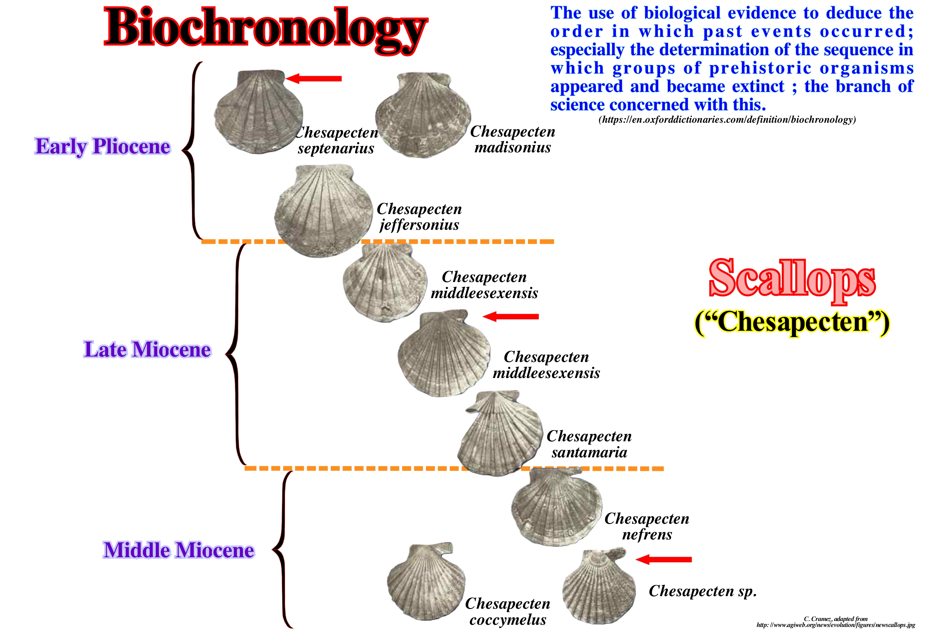
Biochronology attempts to correlate, in time, biological events from the fossils (remains of living beings or evidence of their biological activities preserved in various materials). The biochronology corresponds to an organization of the geological time according to the irreversible process of the continuity of the organic evolution (resolution of ± 1 My). Biochronology contrasts with biostratigraphy (relative dating of sedimentary intervals from fossils). The biostratigraphy is iterative. It is based on the observation of superposition of successions of fossils without their own chronological significance (which means that an inverted biostratigraphy or with many gaps through no deposition is perfectly useful as long as it is consistent). It is the arrangement and temporal correlation of the biostratigraphies that make up the often devalued role of biochronology. In this figure the Miocene/Pliocene biostratigraphy using fossil scallops (lamelibranch molluscs of the family Pectinidae, also known as fans or combs whose scientific name is Pecten maximus, are found in several oceans and are much appreciated in the gastronomy). Chesapecten is an extinct genus of scallops, which lived from the Early Miocene to the Early Pleistocene. The problem between biochronology and biochron boundaries was analyzed by M. R, Palombo and R. Sardella (2007), using the faunas of the large mammals of the Pleistocene of Italy: (i) Reconstruction of Neogene/Quaternary biostratigraphy in continental environments and recognition of the boundaries between the successive mammalian fauna complexes is a very difficult exercise ; (ii) The definition and application of biochronology has often been sullied by references and inferences from biostratigraphy ; (iii) Discontinuities in the continental sedimentary record, environmental conditions, bias (deviation or deformation in the manner of see) taphonomics (taphonomy is the study of decomposing organisms over time and how they fossilized, if any) and sampling are responsible for the fact that the stratigraphic order of the remains of small and large fossil occurrences - stratigraphic datum - does not necessarily reflect the temporal order of true first and last occurrences of taxa (paleobiological events) in time ; (iv) The appearance of the first/last bioevent (recorded in the small/large occurrences of fossil remains in the fossiliferous levels of different continental stratigraphic successions) has been the main basis for the establishment of continental biochronological contexts of mammalian faunas ; (v) From the theoretical point of view, "limits" should be defined by the older and/or young "historical events" of one or more taxa ; (vi) Using examples of faunas (mammals) found in Italy, and in particular those of the transition from Villefranchian to Galerian and from Galerius to Terra/Aurelian, it is difficult to define a stable scheme, which can be applied as a basis for correlation by international scientific community. Biochronology can be used not only to date fossils, but also to date archaeological objects. The discovery of bones in a sedimentary layer, for example, can quickly be dated by the proximity of other species of animals or plants, whose age is known. Such a date for biochronology must always be complemented by other methods, insofar as the degree of accuracy is very weak. In fact, biochronology, like stratigraphy, does not provide a precise date, but simply an indication of the hierarchy among the strata. In this figure the biochronology of the Middle/Pliocene Initial Miocene, made from the evolution of scallops, that is, between Chesapecten nefrens (Middle Miocene) and Chesapecten septenarius (Early Pliocene) is reconstituted. The problem between biochronology and biochron limits was recently analyzed by M.R. Palombo and R. Sardella (2006), using the faunas of the large mammals of the Pleistocene of Italy. The results of this study were summarized as follows: The reconstruction of Neogene-Quaternary biostratigraphy in continental environments and the recognition of boundaries between successive mammalian fauna complexes is a very difficult exercise. The definition and application of biochronology has often been sullied by references and inferences from biostratigraphy. Indeed, discontinuities in the continental sedimentary record, environmental conditions, taphonomic faults (taphonomy is the study of animal death processes) and sampling are responsible for the fact that the stratigraphic order of the remains of the small and large occurrences of fossil (stratigraphic datum) does not necessarily reflect the temporal order of true first and last occurrences of taxa * (paleobiological events) over time. The appearance of the first / last bioevent ** (recorded in the small / large occurrences of fossil remains in the fossiliferous levels of different continental stratigraphic successions) has been the main basis for the establishment of the continental biochronological contexts of mammalian faunas. Therefore, from the theoretical point of view, "limits" should be defined by the older and / or younger "historical events" of one or more taxa.
(*) The First Apparition, is the earliest (older) occurrence of a stratigraphic section for a given species. The first appearance occurs when members of a new species increase in numbers, they may eventually become sufficiently abundant and generalized to appear in the geological record. The Last Appearance is the most recent (younger) occurrence in a stratigraphic section for a given species. The last occurrence occurs when the species is no longer able to adjust to the changing environmental conditions, its members decrease in number and eventually disappear. Extinction refers to the disappearance by death of each individual member of a species or a higher taxonomic group, the lineage no longer exists. Pseudo-extinction (or phyletic extinction) refers to an evolutionary process by which one species evolves in different species; the original species becomes extinct, but the lineage continues into a daughter species. For example, humans of today (Homo sapiens) have replaced an already extinct species (pseudo-extinction) called Homo sapiens neanderthalensis (Neanderthal Man). (http://basin.earth.ncu.edu.tw/ download / courses / sequence_strat / 4_biostratigraphy.pdf)
(**) A bioevent is an event recognized in a sequence of sedimentary rocks, where there is a significant change in the biota as recorded by set of fossils over a relatively short period of time. A bioevent has been defined as "local, regional or interregional short-term changes (hours or days to thousands of years) of the ecological, biogeographic and / or evolutionary character of biotas that are isochronous or almost and throughout their range." Bioevents either related to the diversification of a particular fossil group or a reduction, may be events of speciation or extinction events, or may represent solely a migration. Records of the appearance and disappearance of a particular rate in a single locality are insufficient to define a bioevent. (https://en.wikipedia.org/wiki/Bioevent).
Bioclast...............................................................................................................................................................................................................................................Bioclaste
Bioclasto / Bioclasto / Bioclast / 生物碎屑 / Биокласт / Bioclaste /
Secretion of calcite and aragonite from plants and animals of all types, excluding non-carbonated fossil remains. Different organisms produce different skeletons with different structures. Each type of organism has characteristics, which allow a relatively easy identification on thin sections.
See: « Sediment »
&
« Fossil »
&
« Calcite »
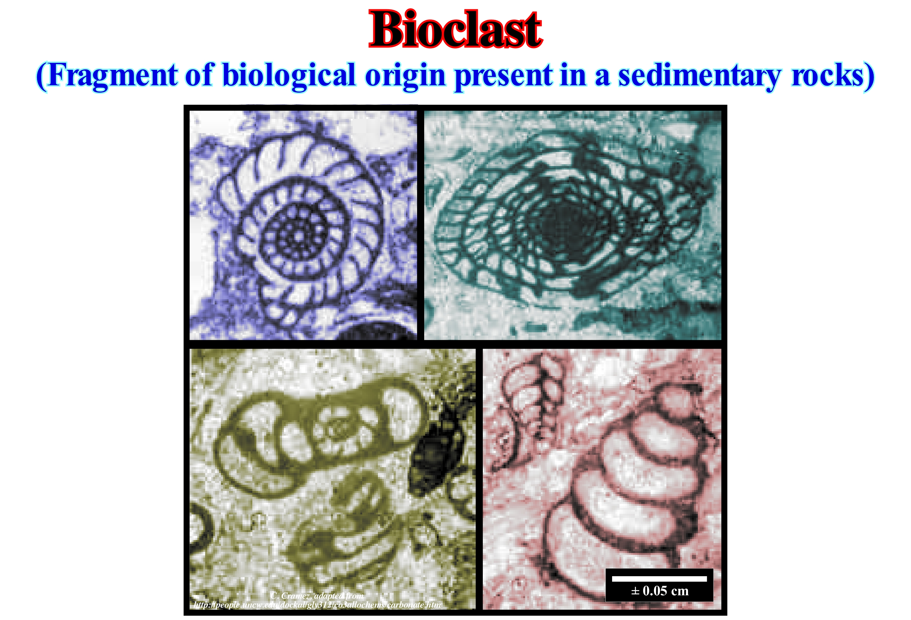
The foraminifera* are, perhaps, the organisms most frequently found in the bioclasts of the carbonate sedimentary rocks, when the principal mechanism of deposition is gravitational. This is very interesting, since foraminifera are extremely useful in sequential stratigraphy. The foraminifera, under certain conditions, allow the dating of the stratigraphic cycles, since they have a geological distribution from the Cambrian to the Present. The first forms of foraminifera, which appear in the stratigraphic records, correspond to simple agglutinated organic tubes. The foraminifera with resistant shells begin to appear in the Devonian, the geological period during which the fusulinids began to develop, reaching maximum development in the Carboniferous and Permian, before disappearing completely at the end of the Paleozoic. The first milliolids** appear in the Early Cretaceous. Later, in the Mesozoic, appeared the rotalinids and, in the Jurassic, the textularinídeos. The first forms were all benthic (found on the bottom of the sea, lake or any other body of water, regardless of depth). Planktonic forms, which derive in the pelagic zones of the oceans or in freshwater bodies, began to appear in fossil records from the Middle Jurassic, in particular on the north shore of the Tethys Sea *** and European epicontinental basins. The highstand geological conditions and high-temperature (greenhouse) that reigned in the Cretaceous contributed to the diversification of planktonic foraminifera but also to the great extinction that occurred at the end of the Cretaceous and in which many planktonic forms disappeared. A rapid explosion of the foraminifera occurred in the Paleocene with appearance of globigerinas and planktonic globorothalias and in the Eocene with the numulites, soritidaes and orbitoids.
(*) The foraminifera (from the Latin "hole-holders") are ameboidal protists, mainly marine, although there are also freshwater species, characterized by a skeleton or shell made up of one or more interconnected chambers that fossilize easily. The foraminifera form what many people call "living sand", alluding to its benthic habitat on the seabed.
(**) Group of benthic foraminifera with porcelain-like shells, composed of small crystals of calcite and organic material. The small crystals of calcite have a high percentage of magnesium and are randomly oriented. The forehead has no pores and usually has several compartments, which are usually arranged in a distinct way, called miliolida.
(***) Sea, between the NE of the small supercontinent Gondwana and SE of the small supercontinent Laurasia, which replaced the Paleo-Tethys ocean (formerly the Sea of Tethys of Suess, i.e., the Paleozoic Ocean, between Gondwana, Central Europe, Iberia, China and Central Asia). The Tethys Sea began to form in the south of the Paleotethys since the Cimmerian plate was individualized (Permian/Triassic). The expansion of the Tethys Sea forced the Cimmerian plate to collide with the Laurasia, to, finally, the Tethys Sea completely replace the Paleo-Tethys.
Biogenic Gas.....................................................................................................................................................................................................Gaz Biogénique
Gás biogénico / Gas biogénico / Biogene Gase / 生物气 / Биогаз / Gas biogenico /
Gas produced in the sedimentary beds, located above the oil window, by the action of bacterias. Economic accumulations of biogenic gas are known, but, in general, they are not economical.
See: « Methane »
&
« Gas »
&
« Gas Window »
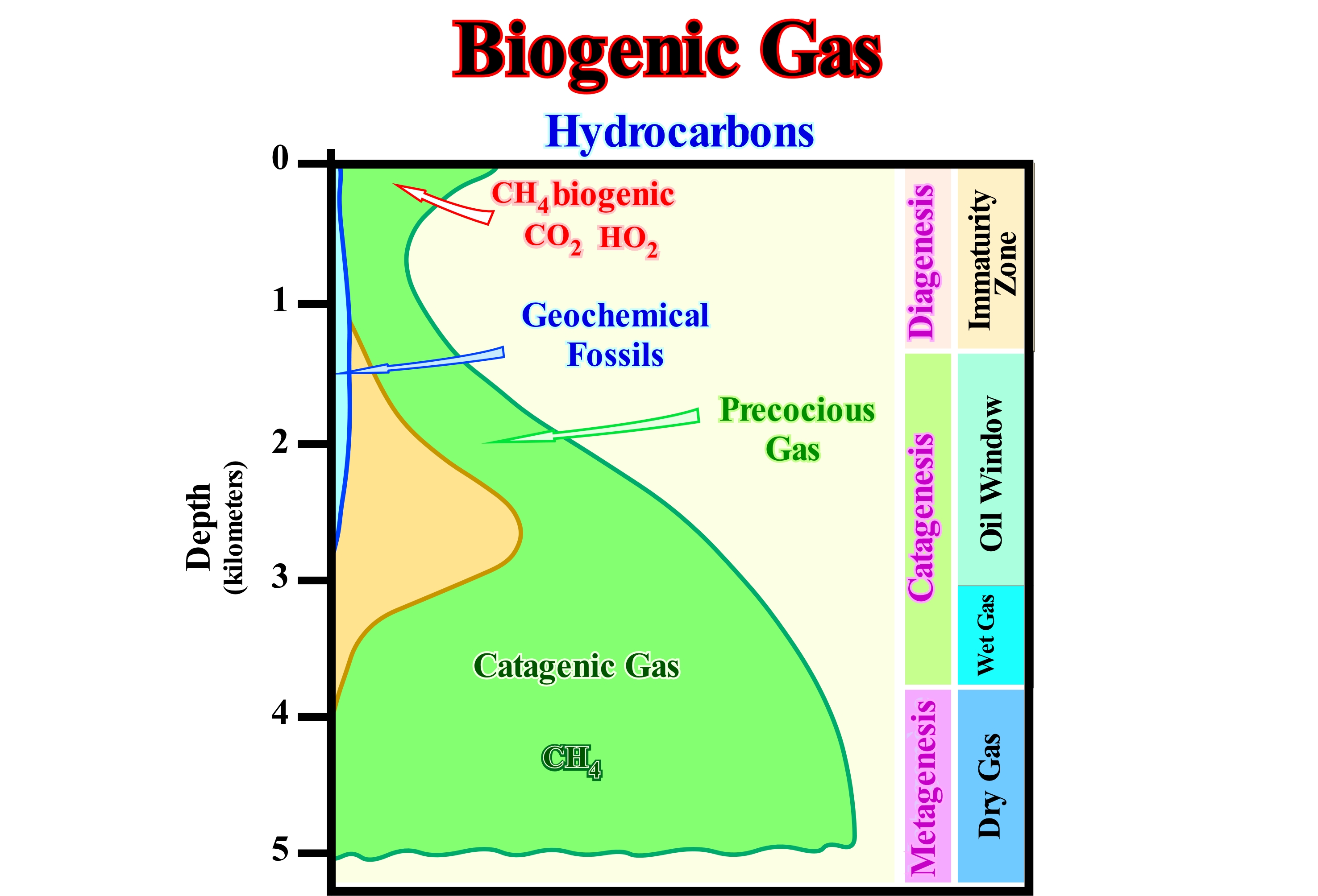
This figure illustrates the scheme, generally, adopted by the vast majority of geoscientists of the genesis of hydrocarbons as a function of depth to an average geothermal grade. Three large zones can be differentiated: (i) Diagenesis ; (ii) Catagenesis and (iii) Metagenesis. It is in the zone of the diagenesis, when the organic matter contained in the sediments is still immature, that forms the biogenic methane (also called gas of the marshes). This gas results from the decomposition of organic matter by the action of anaerobic microbes (which do not tolerate oxygen and high concentrations of sulfate). The formation of biogenic gas is significant in certain environments such as: (a) Poorly drained swamps and bays; (b) Bottom of certain lakes ; (c) Marine environments below the sulfate reduction zone. Biogenic gas forms at a small depth near the surface, while wet gas (more than 85% methane, but with ethane and other more complex hydrocarbons) and dry gas (natural gas without condensates or liquid hydrocarbons and with a gas / oil ratio greater than 100,000 scf / STB, i.e., "stock tank barrel"), are formed, respectively, in the area of catagenesis and metagenesis, at depths ranging from 3 to 5 kilometers (function of thermal flow). The oil window, where most liquid hydrocarbons form, is located in the upper part of the catagenesis zone. Geochemical fossils, which are the organic products produced by plants or animals that cross organic decomposition (diagenesis) and the upper part of the catagenesis without be altered (e.g., hopane - C30H52), disappear, generally, after the oil window. Most geoscientists think that the gas of biogenic origin forms about 20 percent of the world's gas reserves. Several giant biogenic gas fields (proven reserves above 25 Gm3) were recently discovered in the Sanhu area, east of the Qaidam basin in China, in a 3,500 m thick Quaternary depocenter.
Bioherm.........................................................................................................................................................................................................................................Bioherme
Bioerma / Bioherma / Bioherm / Bioherm (由海洋沉积生物体的构造) / Биогерм / Bioerma, Tumulo organico /
Mound structure constructed, in situ, by the growth of skeletons secreted by fixed organisms (organisms attached to the soil without stem or peduncle). Bioherms are, often, recognized on seismic lines, particularly, in the transgressive intervals (TI) of sequence-cycles, which are induced, by successive relative sea level rises in acceleration (marine ingressions increasingly important).
See: « Reef »
&
« Organic Production, Carbonate Function »
&
« Transgressive Interval »
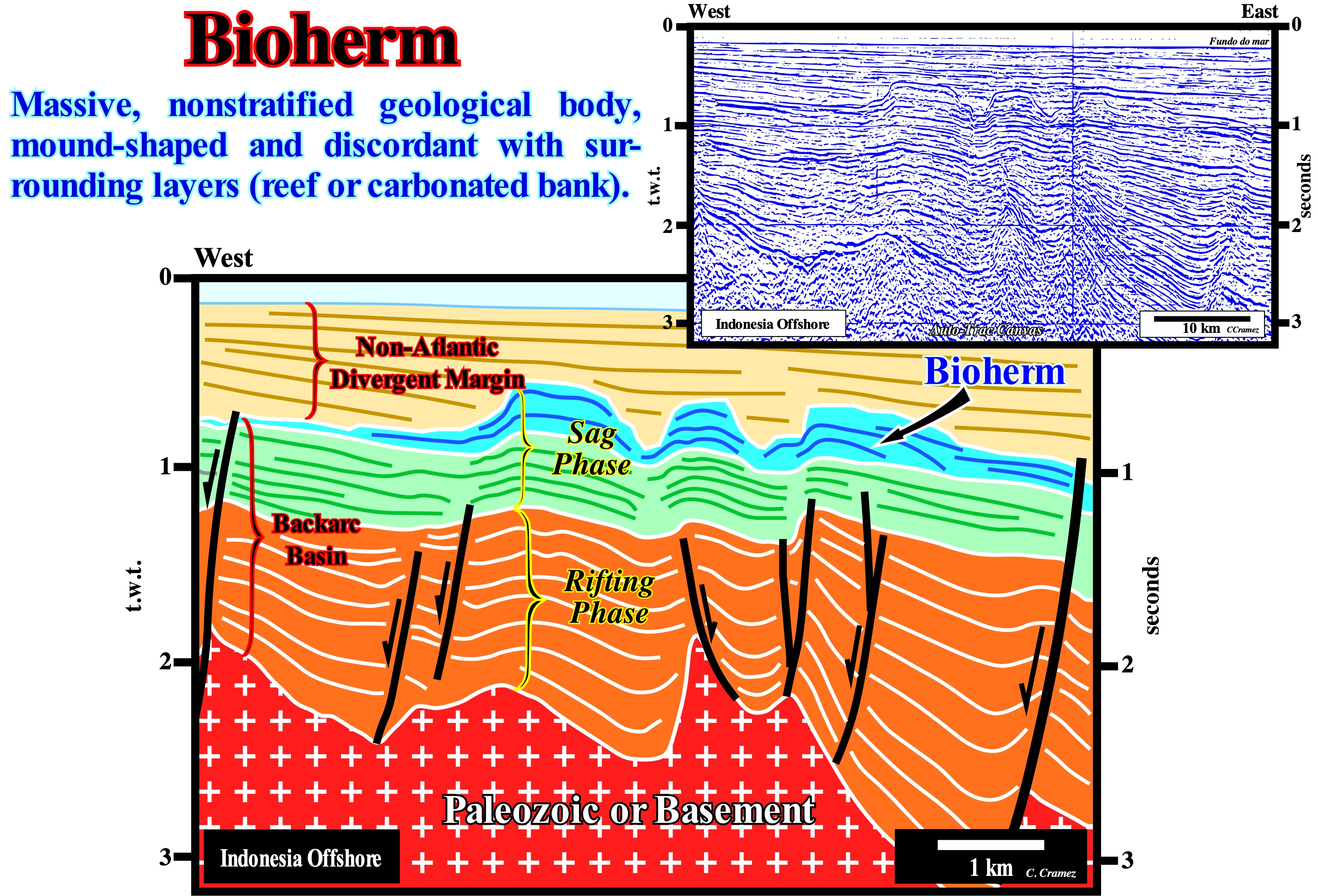
A bioherm is a carbonate or dolomitic sedimentary rock, usually compact or poorly stratified, formed in a shallow marine environment. A bioherm is organized by the constructive activity of colonial corals and by the accumulation of other organisms (calcareous algae, etc.) associated with them. Bioherms are common throughout the Earth and in the geological formations of all geological periods. In this tentative geological interpretation of a Canvas auto-trace of a seismic line detail from Indonesia offshore (near the Malaysia territorial waters), the blue-coloured mounded structures, visible on top of the back-arc basin, are probably bioherms. Considering the geological and global context of this area, which is located within the Mesozoic/Cenozoic megasuture, three types of sedimentary basins of the classification of Bally and Snelson (1980) can be recognized. From the bottom up: (i) Basement, consisting of an old, more or less, flattened, Paleozoic folded belt ; (ii) Back-arc basin, in which half-grabens of the rifting phase (characterized by a differential subsidence) and the cratonic sediments of the thermal or sag phase are quite well visible ; (iii) Non-Atlantic divergent margin, i.e., a divergent margin formed in a, globally, compressive context as a consequence of the break-up of the lithosphere, behind the volcanic arc, and the subsequent opening of a marginal-sea*, i.e., the southern part of the China Sea. The rifting phase of the back-arc basin is, easily, recognized by the thickening of the sediments against the normal faults, along which the area behind the volcanic arch was extended (obviously by normal faults, since rocks can only be lengthened by normal faults). The sediments deposited during this phase are, on this tentative interpretation, colored in orange. The thermal or sag phase is recognized by a parallel configuration of the reflectors, while the divergent margin (non-Atlantic type) is recognized by a progradational configuration of the reflectors. The bioherms developed in the final part of the thermal or sag phase of the back-arc basin during a transgressive episode, in which an increased accommodation (space available for sediments) was induced by relative sea level rise, in acceleration, induced by a series of increasingly important marine ingressions. These marine ingressions displaced continentward (Westward) the depositional coastal break of the depositional surface, which, on the seismic lines, corresponds, roughly, to the coastline, creating the space available for the sediments, which are deposited during the stability period of relative sea level that occurs after each marine ingression. The rate of relative sea level rise (combined action of the absolute or eustatic sea level, which is supposed to be global and referenced to the Earth's centre , and tectonics), seems to have allowed the growth of carbonate organisms, which means that, locally, at the vertical of the organic constructions, the water-depth remains, more or less, constant and that they represent intervals of catch-up carbonates** (they have an aggradational internal configuration). However, in this tentative interpretation, the most distal carbonate anomaly has a progradational internal configuration (keep-up carbonate interval***), which, probably, suggests that it deposited later than the others in association with a relative sea level rise in deceleration. Upstream of the original seismic line of this tentative interpretation, carbonate sedimentary anomalies are fossilized by the progradations of the underlying regressive interval. However, in the more distal area, they were fossilized by the downlapping of the sediments of the divergent margin (non-Atlantic type). These anomalies are excellent rocks-reservoir. Unfortunately, in this offshore they are saturated mainly by CO2 (about 68%). However, the total resources (CO2 + CH4) are of the order of 150 Tcf.
(*) In oceanography, a marginal-sea is a sea, partly closed by islands, archipelagos, or peninsulas, adjacent or widely open to the ocean and / or bounded by underwater ridges on the seabed.
(**) Carbonate with more or less parallel geometry, which is mainly found in the transgressive intervals when the rise of the relative sea level is compensated by the accumulation of carbonate.
(***) Carbonate with oblique (progradational) geometry that deposits when the rate of carbonate production exceeds accommodation. Under these conditions, the carbonate material is required to deposit, by progradations, more or less, oblique, downstream of the platform edge.

