
Periodic Paracycle.........................................................................................................................Paracycle séquence périodique
Paraciclo-sequência (periódico)/ Paraciclo secuencia periódico / Periodische paracycle / 幕式准周期 / Периодическая парасеквенция / Paraciclo periodico /
One of the two types of sequence-paracycles that can be found in a sequence-cycle. Episodic sequence-paracyces are induced by the Milankovitch orbital cycles. They are particularly visible, especially in the transgressive intervals (TI) of the sequence-cycles.
See: « Fifth Order Euatatic Cycle »
Perisutural Basin.....................................................................................................................................................................Bassin périsutural
Bacia perissutural / Cuenca perisutural / Perisutural Becken / 缝合带边缘盆地 / Перисутурный бассейн / Bacino perisuturale /
A sedimentary basin that develops at the periphery of a megasuture, in association with a B-type or A-type subduction, such as foredeep and forearc basins.
See: « Sedimentary Basin »
Permafrost..............................................................................................................................................................................................................................Pergélisol
Pergelissolo / Pegelissolo / Permafrostboden / 永久冻土 / Вечная мерзлота / Permafrost /
Soil condition that prevails in an area whose average annual temperature is 0° C. Synonym with Permafroste.
See: « Glaciation »
&
« Milankovitch's Cycle »
&
« Polar Wandering »
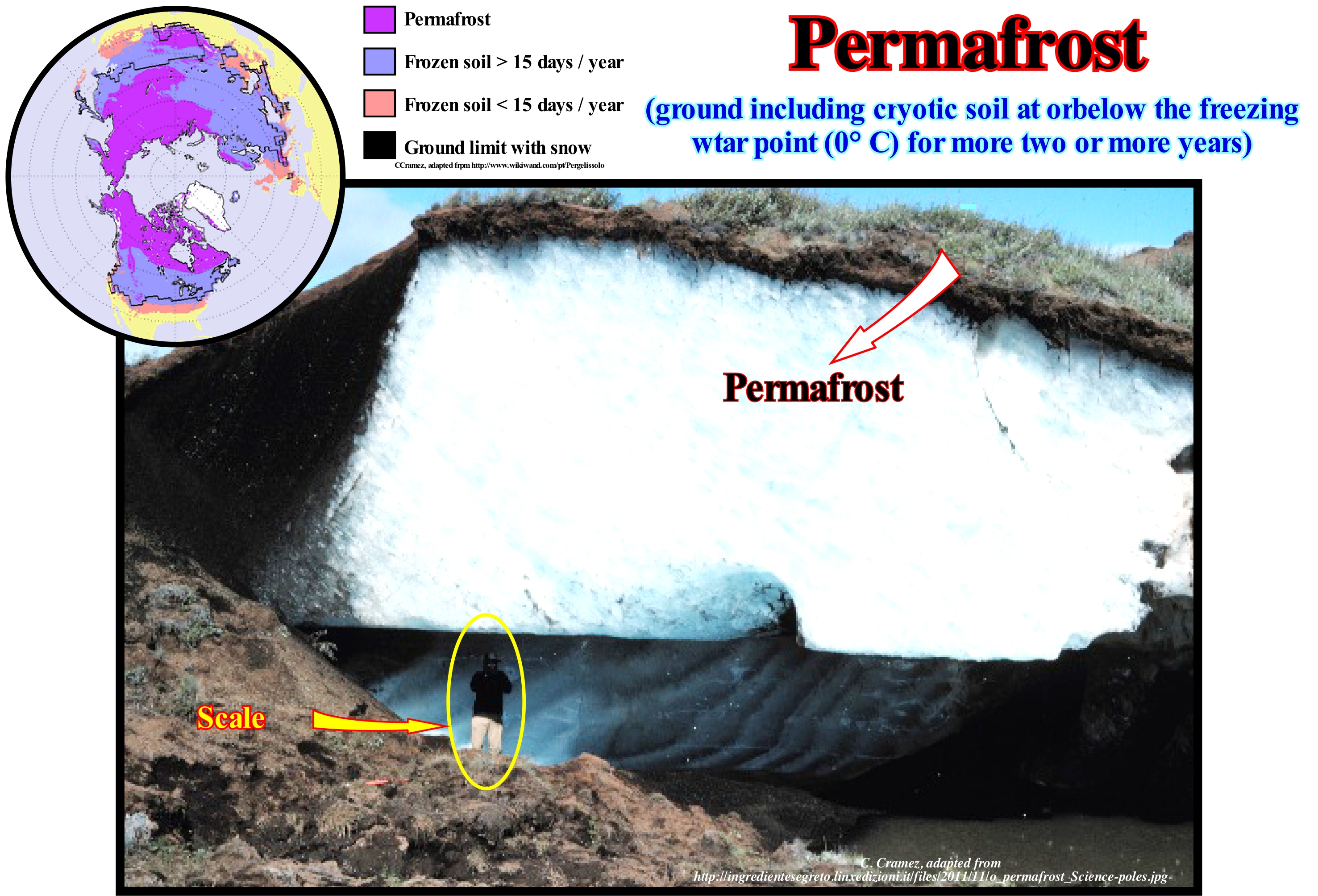
Although certain soil scientists (geoscientists who study the nature of the soil) disagree with the definition of permafrost given by the geoscientists (which include the soil in the description of the permafrost, which is not the case of the specialists of the study of the soils), in our context the definition proposed by wikipedia, suits us perfectly: "Only at or below the freezing point of water (0° C) for two or more years". Of course, in this definition the geoscientists include in the term soil, not only the soil itself, but also the regolith, as well as the sediments or the underlying rocks. Ice in a permafrost is not always present, as in the case of a non-porous substrate, but often it occurs and may be in quantities exceeding the hydraulic saturation potential of the materials forming the ground. Most of the permafrost occurs in the northern hemisphere between latitudes 60° N and 68° N. Northward of 67° N the permafrost diminishes, quickly, as the exposed terrestrial surface disappears towards the Arctic Ocean. There is also a large amount of permafrost at about 35° N, on the Qinghai-Xizang Plateau (Tibet) and in the mountains of South-East Asia, as well as in the Rocky Mountains (USA). About 37% of the permafrost of the Northern Hemisphere occurs in the West of North America, mainly, in Alaska and North of Canada, between 165° and 60°. Much permafrost occurs in the eastern part of the northern hemisphere, mainly in Siberia and eastern Russia, northern Mongolia, NE China, Qinghai-Xizang Plateau, as well as, in the surrounding mountains, between 60° E and 180° E. The extreme temperatures that produce the permafrost, reduce, considerably, near the great water-bodies. That is why Scandinavia and Iceland have, relatively, little permafrost. A thick snow cover can play a very important role in the formation and preservation of the permafrost. In the permafrost permanent areas, the presence of snow warms the soil temperature, as in the areas of discontinuous or sporadic permafrost, the absence of snow favours its formation.
Permafrost (Arctic & Antarctic)...............................................................................................................................................................Permafroste
Permafroste / Permafrost (capa de hielo permanente) / Permafrostboden / 永久冻土 / Вечная мерзлота / Permafrost /
Soil conditions that prevail in a given area, whose average annual temperature is 0° C. Synonym with Permafroste.
See: « Glaciation »
&
« Milankovitch's Cycle »
&
« Polar Wandering »
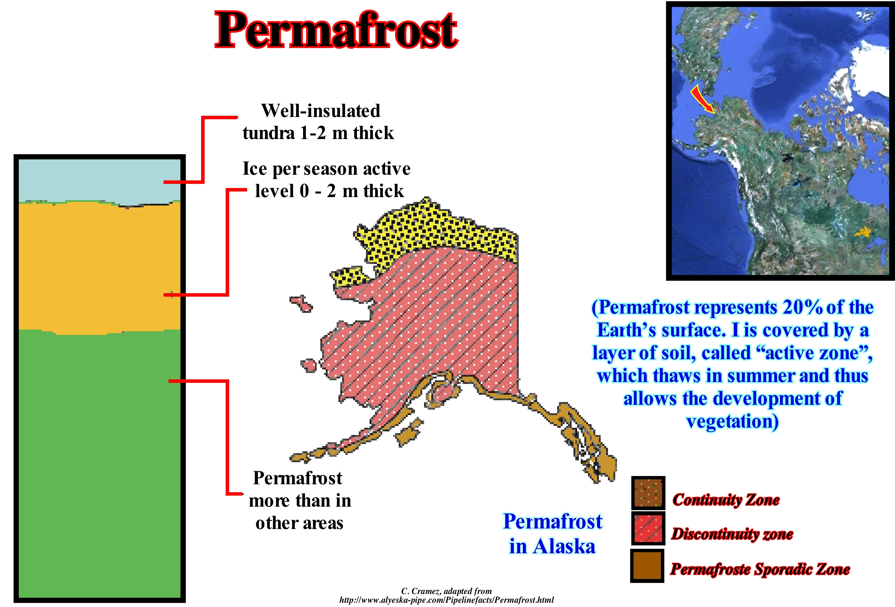
As illustrated in this figure, in Alaska (North America) several permafrost zones may become evident: (i) Continuity ; (ii) Discontinuity ; (iii) Sporadic Permafrost Zone. The continuity zone is the zone where permafrost is found throughout the area. It includes the North Slope and most of western Alaska. In the Discontinuity Zone, the permafrost is found, intermittently. This zone includes most of the interior of the state of Alaska. In the Sporadic Permafrost Zone,, as the name suggests, permafrost is found just in small, permanently icy masses of land. In the same way, different types of permafrosts can be considered: (a) Permafrost Cold, that is, with a temperature that remains below 0° C and that can reach -10° C like in the Northern Slope (this type of permafrost supports the introduction of a considerable amount of heat without melting) ; (b) Permafrost Rich in Ice, i.e., it contains about 20% to 50% ice ; (c) Permafrost with Stable Fusion, i.e., a permafrost in firm rock (substrate), which is, generally, composed of well drained coarse sediments, such as sediments of fluvio-glacial fans (there is fusion, subsidence and deposition are insignificant, and the substrate remains firm) ; (d) Permafrost with Unstable Fusion, which occurs, mainly, in thin and poorly drained sediments that contain large amounts of ice, especially in silts and shales (the melt result is, in general, a loss of strength, excess deposition and flow) and (e) Permafrost Hot, which remains just below 0° C and melts with a little heat. The pingos seen in Alaska and Mackenzie Delta Building (Canada) are small mounds that can reach 50 meters in height and with a crater at the top, which resemble small volcanoes. These structures are formed where the groundwater enters the frozen interval of the ground and constitutes a true water laccoliths (intrusive body of igneous rock installed between sedimentary layers), that when transformed in ice, sufficiently, increases of volume and pressure of crystallization to give these structure an eruptive characters.
Permafrost Table..............................................................................................................................................................................Table de pergélisol
Mesa de pergelissolo / Tabla de permafrost / Permafrostspiegel / 多年冻土表 / Верхний горизонт вечной мерзлоты / Permafrost tavolo /
Upper boundary of the permafrost, i.e., of the soil with a 0° C or lower temperature during two or more years. Synonym with Permafroste Mesa.
See: « Permafrost »
&
« Milankovitch's Cycle »
&
« Glaciation »
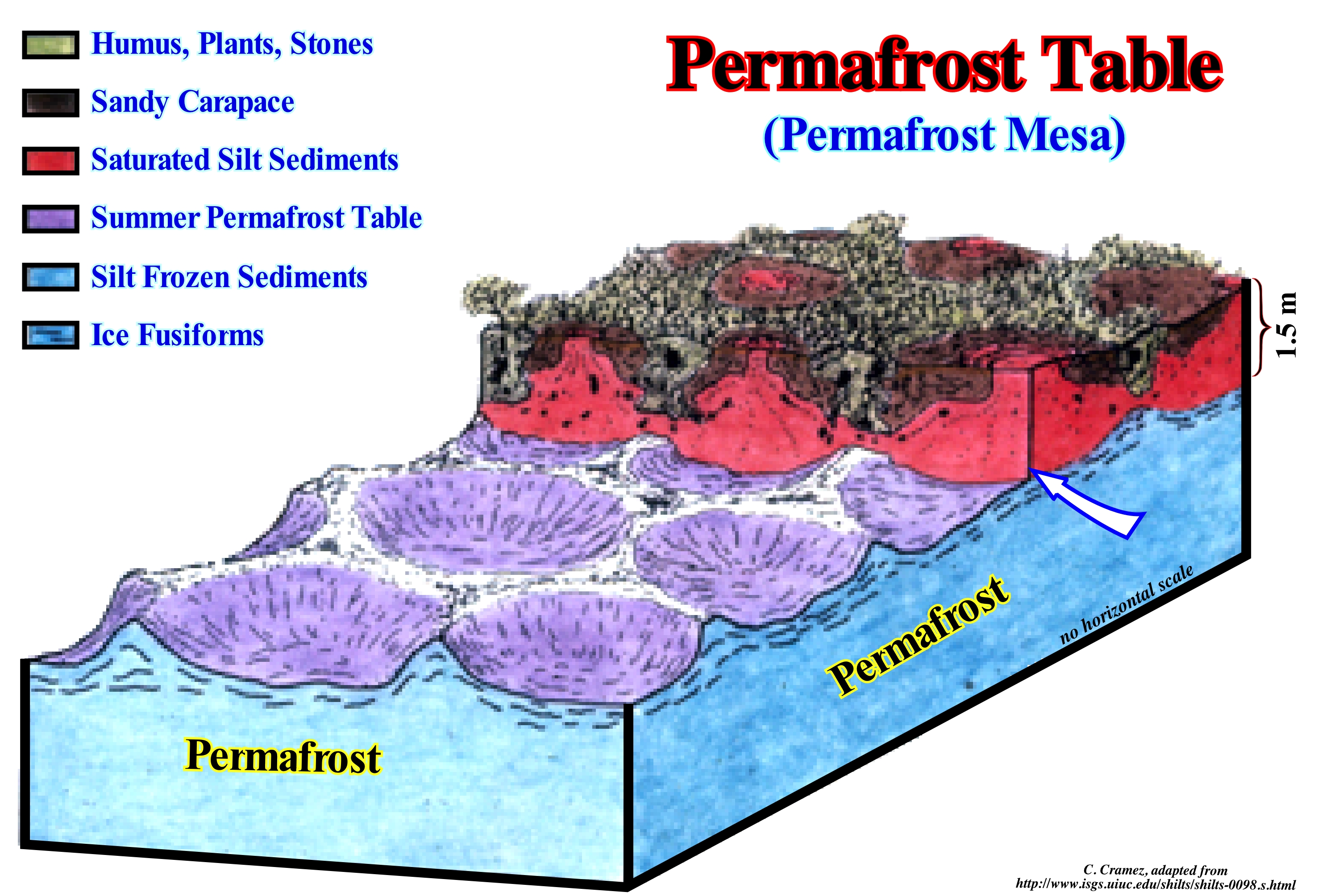
This figure, based on a scheme by R.G. Skinner, which used the data obtained from the excavations of the region around Kaminak Lake (south-west of Nunavut in northern Canada) shows, clearly, the typical configurations of a permafrost surface, under the summer defrost layer. From top to bottom, we can recognize: (i) The superficial layer composed of humus, stones and plants ; (ii) The sandy carapace ; (iii) The silt layer saturated with water ; (iv) The summer permafrost table ; (v) The frozen siliceous layer and (vi) The ice lentils. The permafrost without water and, therefore, without ice, is called dry permafrost. The top surface of the permafrost is the table. In the permafrost areas, the surface horizon of the soil, which gels during the winter (seasonally frozen land), but merging in the summer, i.e., the horizon overlying the permafrost, is the active horizon. The thickness of this horizon depends, mainly, on its composition. It may have a thickness of less than a dozen centimeters when the sediments are dry and rich in organic matter, and a few meters when the sediments are sandy and with great porosity. It is in this layer that plant life is possible. Most of the permafrost is located at great latitudes, near the poles, but there is also the alpine permafrost at low latitude, but at high altitude. The extent of the permafrost varies, greatly, with the climate changes that have affected and will affect the Earth's surface. Most of the Arctic is covered with permafrost (including, of course, the areas of discontinuous permafrost). In regions where permafrost is continuous with very hard winters, such as in Siberia, north of the Lena and Yana rivers, the thickness of the permafrost can reach more than 1,000 meters. In the northern hemisphere, the continuous permafrost line is defined by the points to the north of which, sometimes, the permafrost merges or is interrupted by regions without permafrost. Northward of this line, whole ground is covered by permafrost or ice glacier. Northward of certain latitudes, this line can, gradually, move to the north or south of regional and global climate change.
Permafroste Mesa...............................................................................................................................................................Table de Permafroste
Mesa de permafroste / Tabla de permafrost (capa permanente de hielo) / Permafrostspiegel / 多年冻土表 / Верхний горизонт вечной мерзлоты / Permafrost tavolo /
Depth of permafroste. This surface, whose maximum temperature is 0° C, is covered by the active layer, which gels in the winter, but melts in the summer, and where a certain plant life is possible. Synonym of Permafrost Table.
See: « Permafrost Table »
&
« Glaciation »
&
« Milankovitch's Cycle »
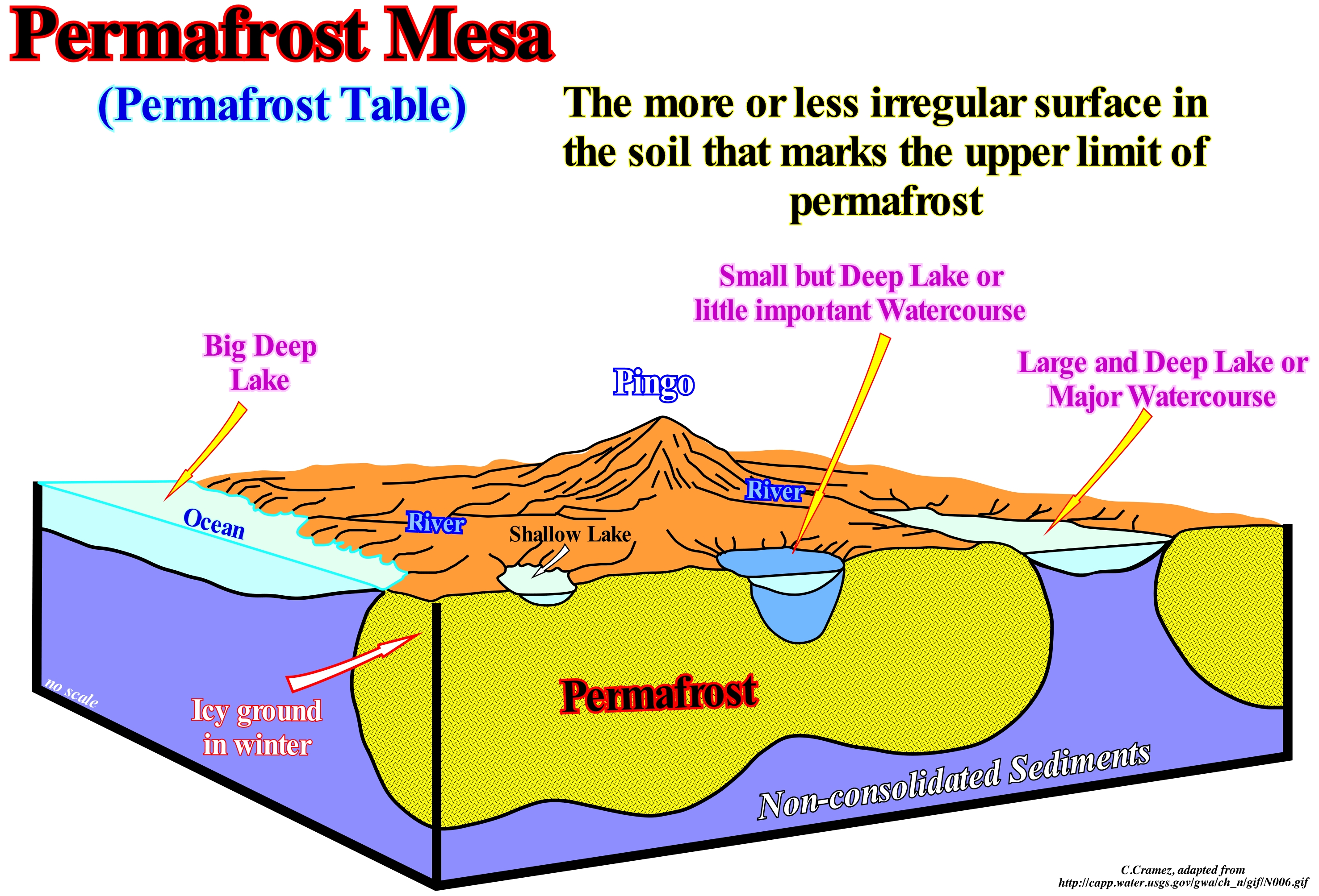
In the Northern Hemisphere, permafrost occupy more or less 23 Mkm2, that is, about 24% of the surface of the hemisphere. Permafrost occurs from about 84° N (in northern Greenland) to 26° N (in the Himalayas). The permafrost is not defined according to the composition of the soils, snow cover or location but only, depending on the temperature. Any rock or soil remaining at a temperature below 0° C for at least two years is a permafrost. Permafrost can contain more than 30% ice or, virtually, no ice. Understanding and locating permafrost is not only important in civil engineering and architecture,but it is very important to better understand climate change as well. In terms of extension the permafrost can be: (i) Continuous ; (ii) Discontinuous ; (iii) Sporadic and (iv) Isolated. As these terms are, purely, descriptive, the boundaries between these different permafrost zones are very vague. Determining the location and extent of permafrost can, sometimes, be very difficult. It is assumed that the soil temperature is equal to the air temperature, but they may be very different since, even in areas with a mean temperature below zero, permafrost may not exist. As illustrated in this figure, often, under glaciers, rivers, lakes and streams, the permafrost may be absent or have a much deeper permafrost table, although the air temperature is less than zero. In certain parts of Alaska, as illustrated in this sketch, the permafrost lies deep beneath the deep lakes, with an intermediate depth beneath small, deep lakes and almost near the surfaces under small shallow lakes. It may not even exist under deep-water lakes. In oil exploration, the knowledge of permafrost table depth is crucial for interpretation and reprocessing of seismic lines shot in these areas, since the permafrost introduces lateral variations on seismic wave velocity.
Permeability (Fluid).......................................................................................................................................................................................Perméabilité
Permeabilidade / Permeabilidad / Durchlässigkeit / 渗透 / Проницаемость / Permeabilità /
Ability of a material, such as a rock, to convey fluids or the connectivity of the pores of a rock. The pores of a rock must be connected to one another so that the oil, gas or water, that is to say, the saturating substance can flow through it. The permeability depends, more or less, on the square of the granulometry. If laterally, the diameter of the sand grains of a sandstone increases to double, the permeability increases by a factor of four. By increasing the particle size by a factor of ten, the permeability increases one million times.
See: « Reservoir (HC) »
&
« Porosity »
&
« Granulometry »
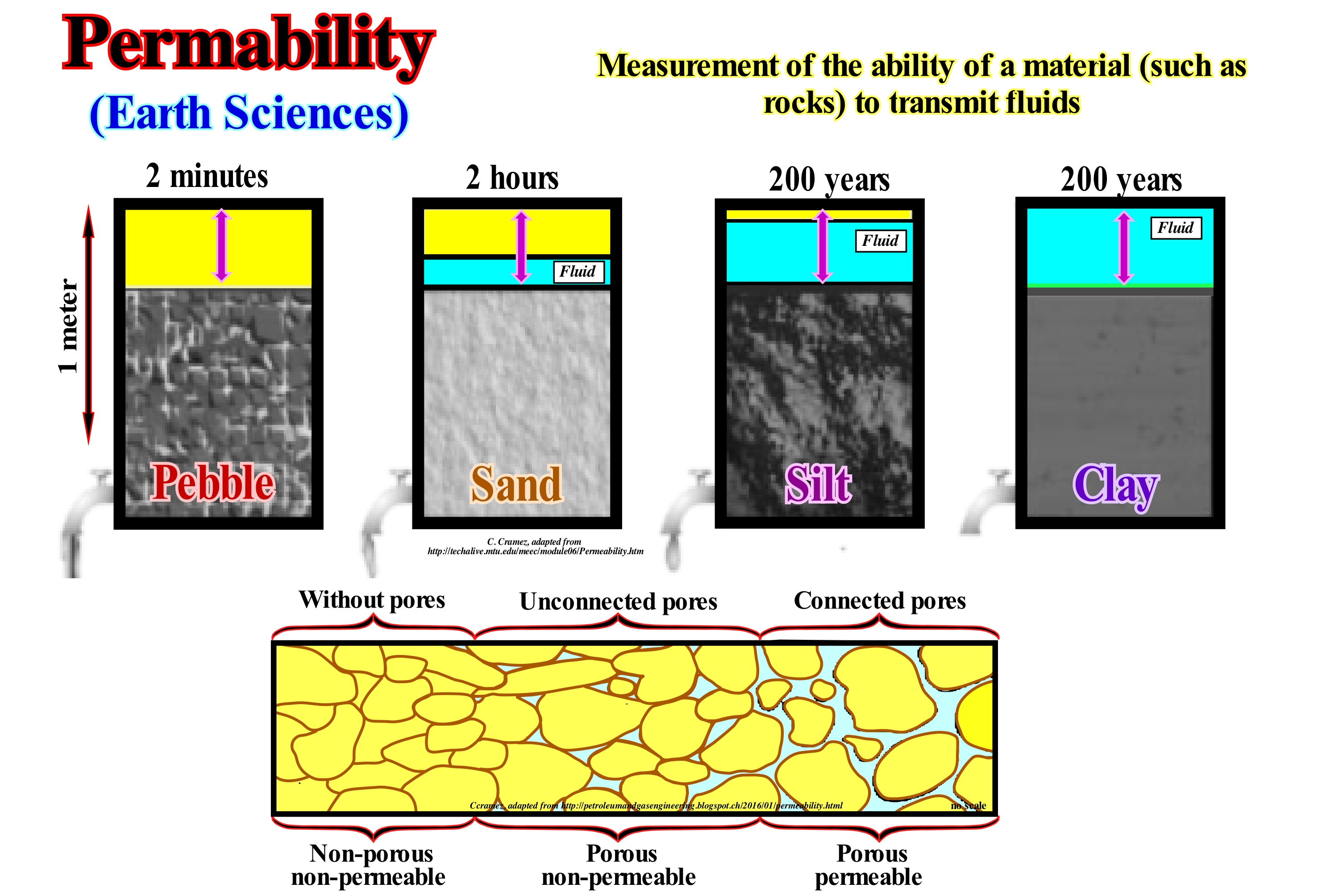
Placing the same column of water on different types of sediments as shown above (gravel, sand, silt and clay) and assuming the water can not evaporate, after two minutes all the water disappears above the gravel. After two hours, a large part of the water above the sand disappears by infiltration, but not all, which means that sand is less permeable than gravel. At the end of 200 days, only a small amount of the water placed above the silt has infiltrated, which is nothing compared to the clay. In fact, after 200 years, practically, none of the water placed on top of the clay has infiltrated. This, largely, mental experiment shows how the porosity of a soil or a rock, controls the speed of water displacement through it. It is this capacity, that a material must have to be allowed water to pass through or to transmit fluids. It characterizes, as certain geoscientists say, the permeability of the material. The permeability unit is the darcy. A material having 1 darcy of permeability allows the flow through 1 cm2 of its surface of 1 cm3/s of a fluid having a viscosity (resistance of a fluid that is deformed either by a shear stress or extension) of 1 centipoise (1m Pa.s)*, under a pressure gradient of 1 atm/cm (atmosphere/centimetre). In petroleum geology, the permeability of rock-reservoir is, extremely, important, particularly when the saturant is oil. Often, the profitability of an oil discovery is just dependent on petrophysical characteristics (porosity and reservoir) of the reservoir-rock.
(*) The viscosity of water at 20° C is therefore a centipoise. A surface viscosity is given in Surface Poise. A surface poise corresponds to 1 g/s. The pascal, symbol Pa, is the pressure unit of the International System of Units (SI). It has its name of Blaise Pascal and, according to the rules of the SI, the name begins with a tiny one ("pascal"), but since it comes from a proper name, the symbol begins with a capital letter ("Pa ").
Permian................................................................................................................................................................................................................................................Permien
Pérmico / Pérmico / Perm (Geologie) / 二叠纪 / Пермский период / Permiano /
Last geological period of the Paleozoic Era. The Permian lasted about 38 My, between 248.2 Ma and 286 Ma. It was during the Permian that most of the continental crust, except small continental portions of East Asia, coalesced to form the Pangea supercontinent .
See: « Paleozoic »
&
« Eon »
&
« Geological Time Scale »
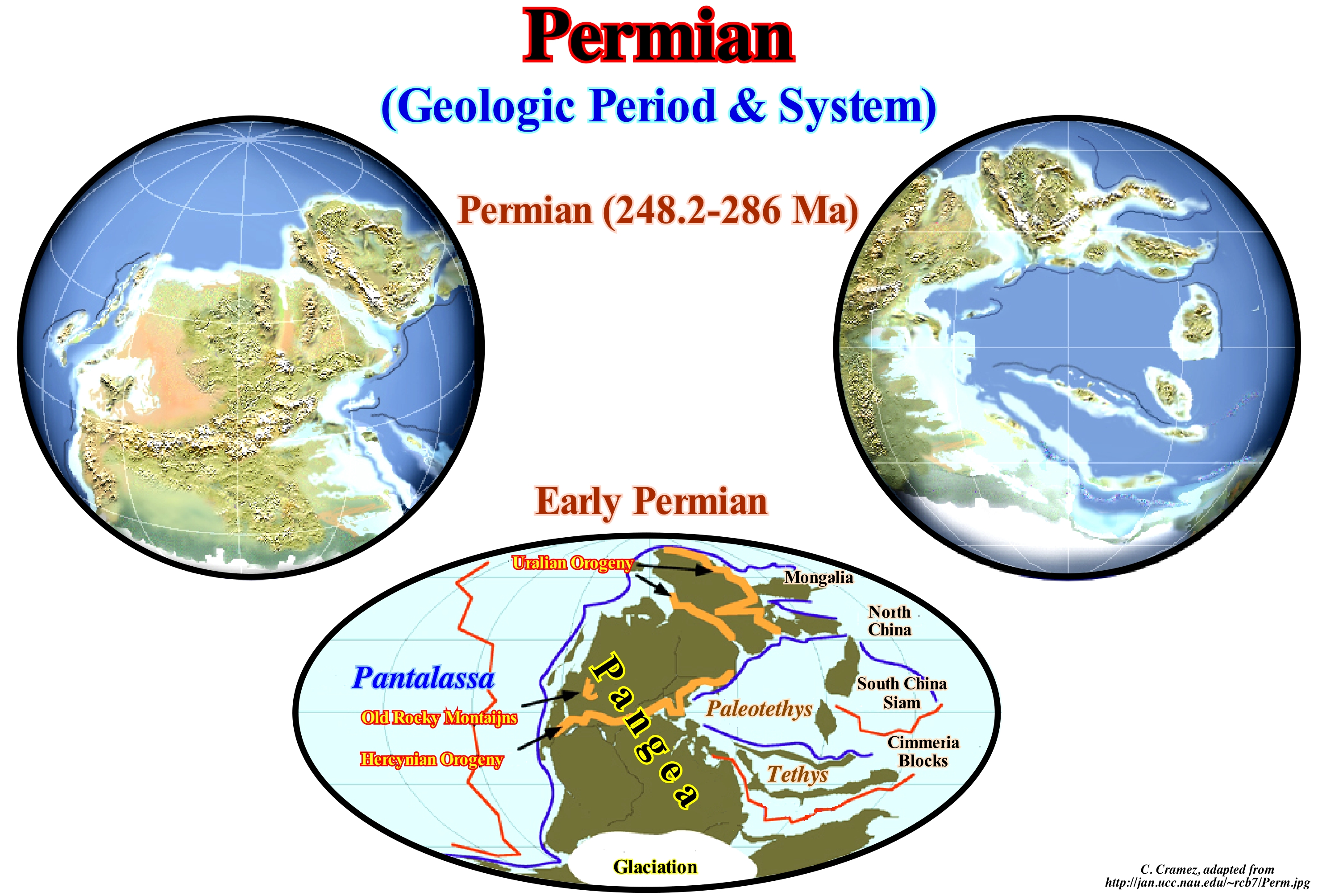
During the Permian, the great majority of the continents agglutinated to each other to form the Pangea supercontinent. As illustrated, the continental blocks of Northern China, China-Siam, Cimmeria, and the small Gondwana supercontinent (South Mainland of Pangea) remained individualized in relation to Pangea. A part of Pangea was located in the northern hemisphere, but most were located south of the equator. All this supercontinent was surrounded by a great ocean called Panthalassa, in which there is a great re-entrance between Asia and Gondwana, which was denominated Paleotethys Sea (Paleotethys Ocean). During this period. the Cimmeria mainland individualized itself of the Gondwana and began its northward trip in direction of Laurasia (North continent of Pangea). As the Cimmeria moved north, not only the Paleotethys sea diminish, but a new ocean, i.e., the Tethys Sea, grew more and more. This new sea became dominant when the Paleotethys disappeared during the Mesozoic Era. During this time, several mountain ranges were formed: (a) Rocky Mountains ; (b) Hercynian and (c) Uralian. Due to the large size of the Pangea supercontinent, all kinds of climates, from extremely cold to hot, meet on Earth during the Permian. There were many deserts during this period. Dry climatic conditions favoured the development of gymnosperms (subdivision of phanerogams with protected seeds) in relation to the ferns ( group of vascular plants, i.e., with with xylem and phloem, that reproduce via spores and have neither seeds nor flowers). Also the first modern plants, like, the conifers, ginkgos and many others appeared in the Permian. From the stratigraphic point of view three regions are very famous for the Permian deposits: (i) The Ural mountains (where the outcrops of the Perm area are the most typical of this geological period) ; (ii) China and (iii) the South-western United States of North America, where the Permian Basin in the state of Texas is probably the sedimentary basin where the Permian deposits are thicker.
Petroleum (Oil)................................................................................................................................................................................................................Huile (Pétrole)
Petróleo / Petróleo / Erdöl / 石油 / Нефть, бензин / Petrolio /
Liquid consisting of organic molecules composed of 5-20 carbon atoms and resulting from the organic matter of the sediments, when it is buried at such depths, that the large organic molecules are cracked in small. Although in a wrong way, the term petroleum is considered, by some geoscientists, as a synonym with Oil.
See: « Oil »
&
« Hydrocarbon »
&
« Source-Rock »
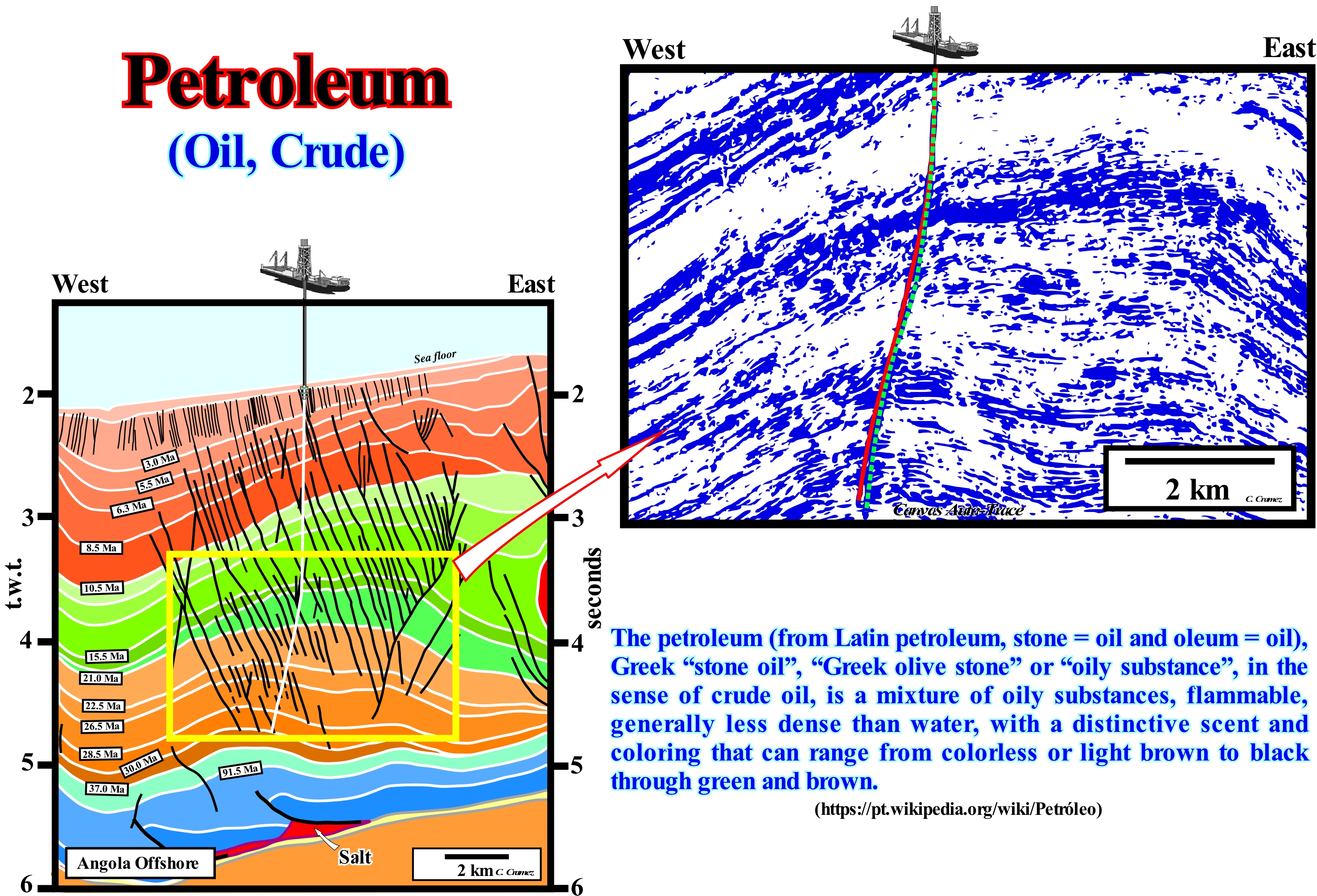
When sedimentary rocks rich in organic matter (potential source-rocks) are buried at a depth of about 2,000/2,500 m (function of thermal flow), the large organic molecules break into small pieces. The molecules with 5/20 carbon atoms are liquid and form what is, usually, called petroleum. The molecules with less than 5 carbon atoms are gases (at temperatures and ambient pressures) and form what is, usually, called natural gas. When the cracking product consists of a single carbon atom, the gas is pure methane (CH4) and is, generally, called dry natural gas. Although, since the 1980s, smaller and increasingly complex oil fields have been discovered, geoscientists have had, for some years now, not only fantastic drilling techniques but also excellent geophysical means, which allow them to evaluate the oil potential of the deeper offshores, such as the offshore north of Angola. On this tentative geological interpretation of a regional seismic line of the deep offshore of northern Angola (currently the area in the world with the highest success rate of finding good quality oil reserves), it is, easy, to verify the influence of halokinese (salt tectonics) in the formation of hydrocarbon traps. Although, locally, there may be a compressional tectonic regime, the great majority of traps, as we can see, are not structural, but morphological by juxtaposition. This type of traps is formed when the movement along the planes of the normal faults, developed at the high points of the antiforms, to lengthen the sediments, put in juxtaposition the reservoir-rocks of the upper faulted block (footwall) with the sealing-rocks located in the lower faulted block (hangingwall) or when reservoir-rocks with different displacement pressures are in juxtaposition and covered by sealing-rocks.
Petroleum System.......................................................................................................................................................................Système pétrolier
Sistema petrolífero / Sistema petrolífero / Petroleum-System / 石油系统 / Нефтегазоносная система / Sistema petrolifero /
Genetic relationship between a petroleum accumulation (oil or gas) and the source-rock that generated the hydrocarbons.
See: « Oil Pool (hydrocarbons) »
&
« Source-Rock »
&
« Reservoir-Rock »
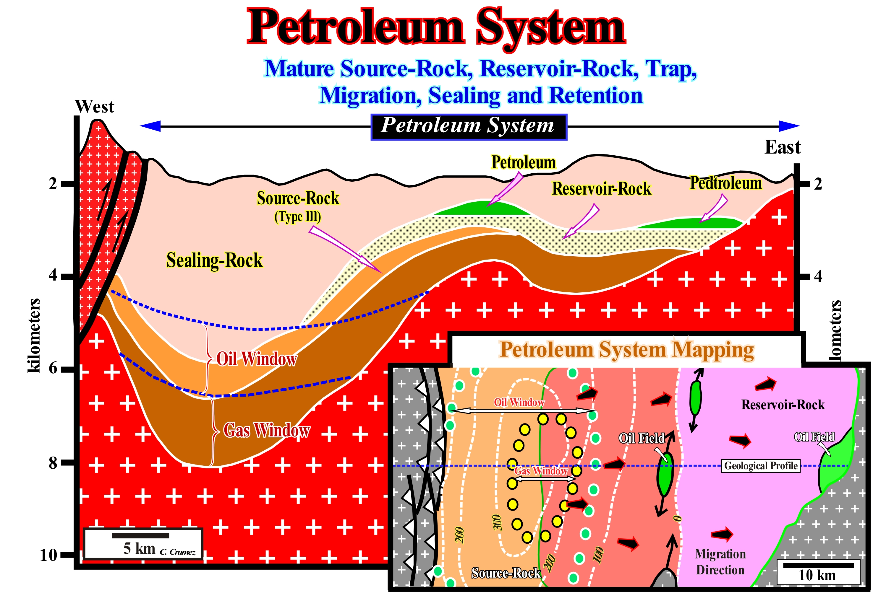
In the petroleum industry, petroleum systems are referred, often, to by the names of the geological formations of the source-rock and rock-reservoir. Thus, for insstance, in the Maturin geographic basin (Venezuela), the "La Luna/Naricual" petroleum system means that the source-rock is within the Luna formation and the rock-reservoir is within the Naricual formation. However, geoscientists confuse, often, a petroleum system, such as La Luna/Naricual with the La Luna generator petroleum subsystem (source-rock). In other words, the La Luna petroleum system does not exist, since a system, in the holistic or contextual (systemic) method, is a whole and not a part. A petroleum system includes all the elements and geological processes that are essential to the existence of an accumulation of oil or gas in nature. These basic elements include: (i) Source-Rock ; (ii) Reservoir-Rock ; (iii) Sealing-Rock ; (iv) Trap and (v) Migration pathways along which hydrocarbons can migrate from the source-rock to the reservoir-rock, where the trap is located (do not confuse source-rock with potential source-rock). All these elements must be, correctly, placed in time and space so that the organic matter included in the source-rock can be converted into an petroleum accumulation. A petroleum system exists when all the basic elements exist or are thought to exist. It can be said an petroleum system (whole) consists of two large subsystems: (a) Generating Subsystem and (b) Trap/Migration Subsystem, which in turn are complex and interdependent, which means that a petroleum system is much more than a simple sum of subsystems. Magoon (1987) considered three types of petroleum systems as a function of the degree of certainty: (1) Known Petroleum System (!), when the correlation between the source-rock and hydrocarbons is known, in particular by biomarkers (in the case of petroleum) ; (2) Hypothetical Petroleum System (.), when there is no correlation between source-rock and hydrocarbon and (3) Speculative Petroleum System (?), when the petroleum system is based just on geological or geophysical data, which still have not been tested by the exploration operations.
Petroleum Window (Oil)............................................................................................................................................................Fenêtre à huile
Janela do petróleo / Ventana de petróleo / Öl-Fenster / 油窗 / Главная зона нефтеобразования / Finestra delle olio /
Oil formation zone. This zone is located at a depth where the temperature ranges from 50° to 120-150° C and, above all, from a hundred degrees, where the transformations of the kerogen into hydrocarbons, particularly, into C15-C40 fractions. This formation preservation zone of liquid hydrocarbons is characterized by organic clues (biomarkers) dependent on the time and nature of the Kerogen.
See: « Source-Rock »
&
« Gas Window »
&
« Kerogen »
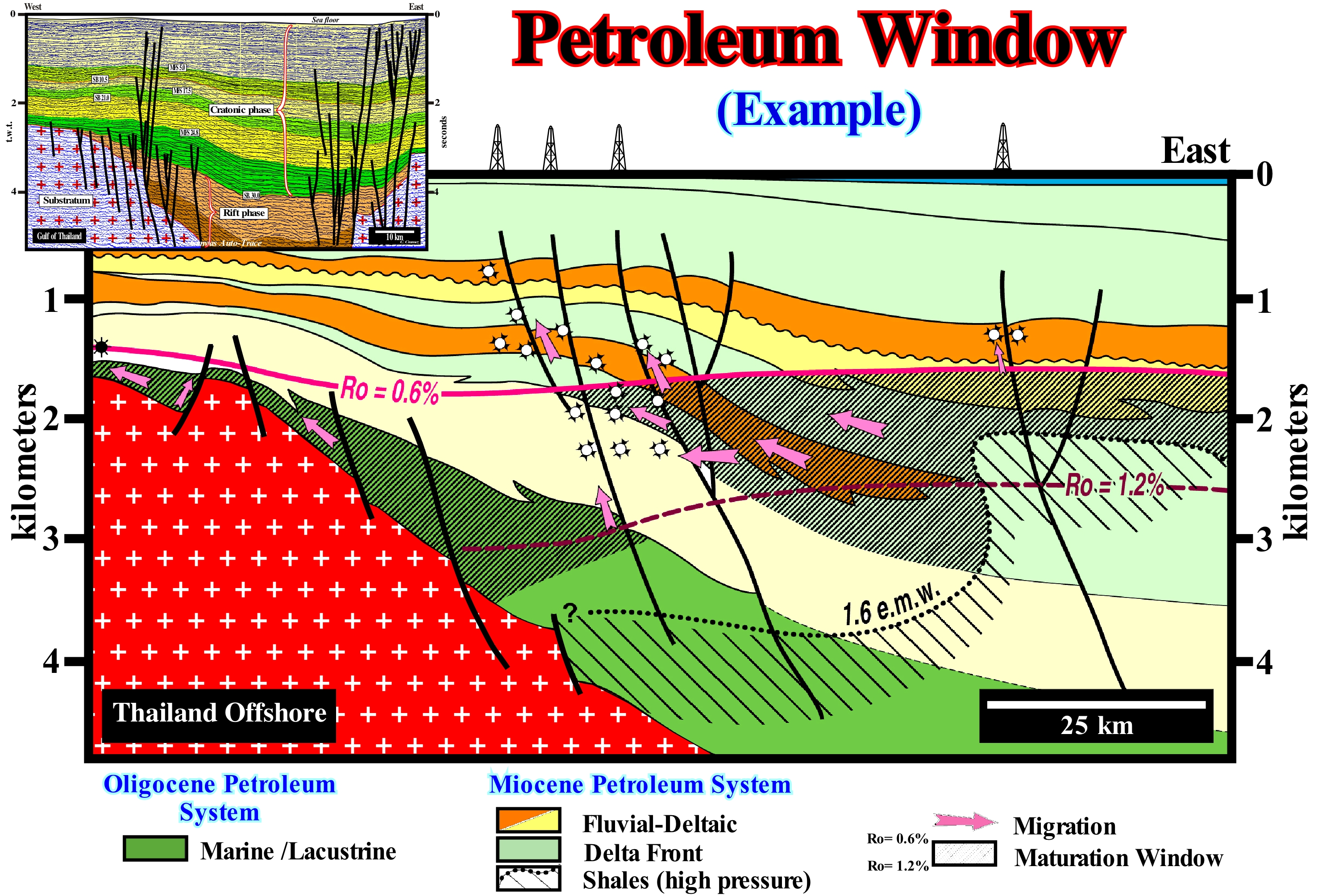
On this tentative geological interpretation of a seismic line of the offshore of Thailand, which corresponds to a back-arc basin, is underlined the most probable petroleum window, between the values 0,6 and 1,2 of vitrinite reflectance. The sediments rich in organic matter were buried to such a depth that organic matter was, probably, transformed into oil. As shown in the figure, the hydrocarbons produced in the two oil fields, traversed by this seismic line, are a mixture of petroleum and condensate. In this way, it is probable that the organic matter of the potential source-rocks is type III, i.e., humic and with a kerogen characterized by an H:C ratio of less than 0.84, produced from the lignin of plants which grow on dry land. In this type of sedimentary basin (back-arc basin), the conventional source-rocks are lacustrine shales that have been deposited in the rift-type basins (initial phase or rifting phase) that, of course, are much more buried than the shales of the cratonic phase. In other words, it can not be ruled out that a part of the petroleum produced in these fields was generated in the deep rift-type basins (halfgrabens) and that it migrated, vertically, along the normal faults planes, to the reservoir-rocks of the morphological traps by juxtaposition. The normal faults of the rifting phase were, slightly, reactivated in reverse faults by a, relatively, recent compressional tectonic regime and that the vast majority of the traps of the pools (do not confuse pool with the oil field) are morphological by juxtaposition and not structural traps. They do not have their own closure (in all directions, i.e., four way dips), which, at least the lateral seal, is made by the juxtaposition of an impermeable interval to the reservoir-rocks.
Petroleum Sand (Tar sand, oil sand).....................................................................Sable asfaltique, Sable betumineux
Areia petrolífera / Arena asfáltica / Teersand / 焦油砂 / Нефтяной песок / Tar sabbia /
Sand containing a sufficient amount of asphalt allowing acommercialization. In general, an asphaltic sand is a bituminous (petroleum) sand, which has lost the light components. Expression, often, considered as synonymous with "Petroliferous Sand" or "Bituminous Sand".
See: « Bituminous Sand »
&
« Sandstone »
&
« Asphalt »
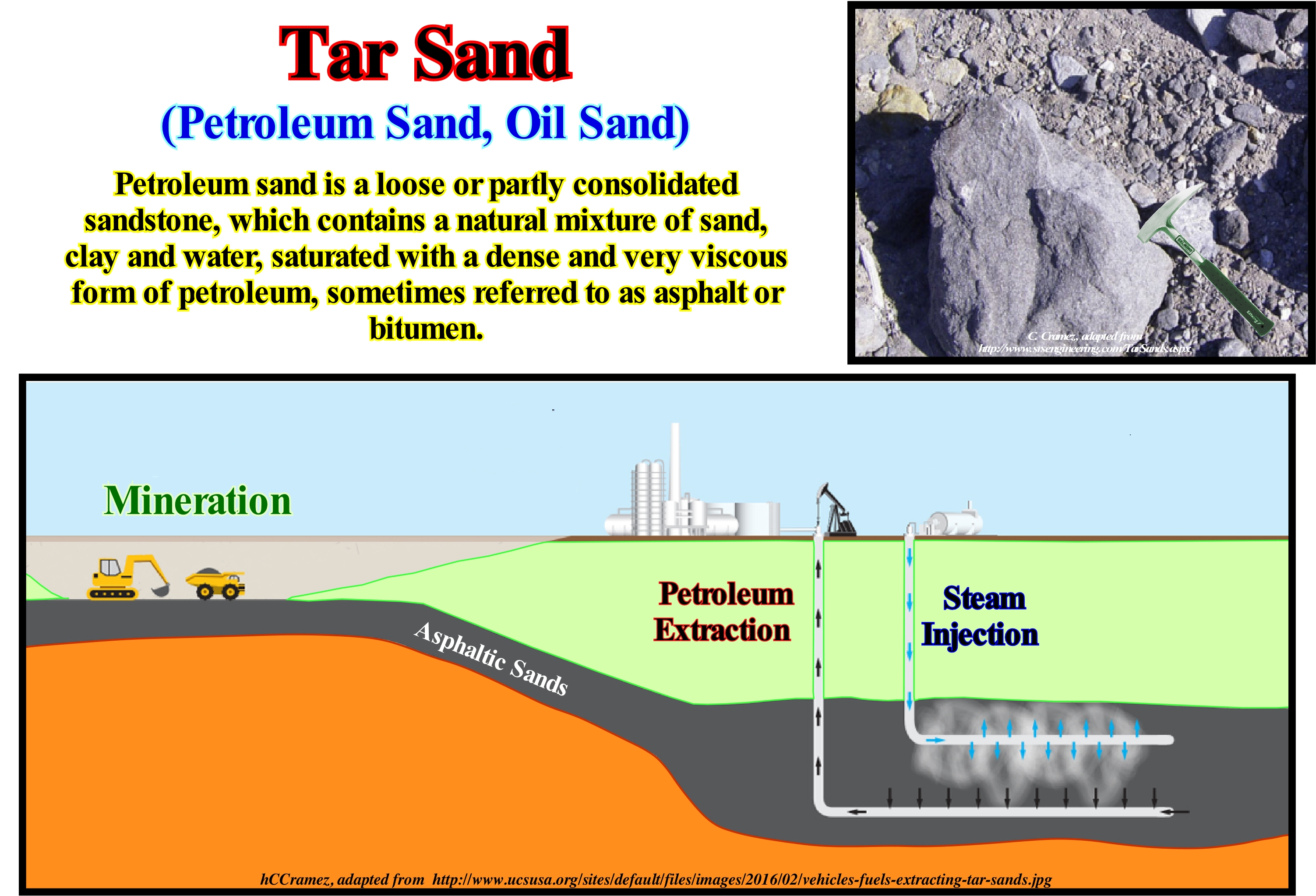
Asphalt sands or petroleum sands (according to certain geoscientists) are a combination of sand, clay, water and bitumen (heavy black and viscous heavy oil). The asphalt sand can be extracted in the open and processed to extract bitumen, which is then converted into light oil. Bitumen from asphalt sand can not be extracted from the ground in its natural state by pumping as is usually, for oil. However, it can be extracted: (i) Open air ; (ii) Drilling ; (iii) Heating with water vapour and (iv) Other recovery processes. Recovery processes are, generally, composed of two phases. An extraction phase and a separation phase, whose purpose is the individualization of the bitumen, clay, sand and water that make up the oil sand. Bitumen needs additional treatment before refining. Since bitumen is very viscous, dilution with lighter hydrocarbons is, almost always, necessary to be transported by pipelines. In southern Venezuela, the so-called Orinoco Oil Belt is, largely, composed of asphaltic sands, since oil along its long southward lateral migration lost its light elements and became a very heavy oil flowing very hard. These oil bearing sands do not outcrop. They are buried at, relatively, small depths (between 300 and 1,200 m). The oil (heavy, about 8-10° API*) keeps the sedimentary particles (grains) in suspension. The oil can be mobilized by steam injection, but the profitability of extraction depends, mainly, whether the extraction is or not accompanied by compensatory subsidence. As the quartz grains are suspended in the heavy oil (they do not touch), as the oil is extracted, in a favourable case, the sand compacts itself which causes a subsidence of the overlying stratigraphic levels, which favours the heated oil extraction. It is this subsidence that is responsible for the depressions (between 4-10 m) observed in the present day topography along the roads neaby the fields.
(*) The API grade is an arbitrary scale (the higher the oil density, the lower its API grade) that measures the density of petroleum liquids, which was created by the America Petroleum Institute along with the National Bureau of Standards and which uses it to measure the relative density of liquids. ° API = ⎨141.5 ÷ δ (density of the sample relative to water)⎬ - 131.5.
Phanerozoic........................................................................................................................................................................................................Phanérozoïque
Fanerozóico / Fanerozóico / Phanerozoikum / 显生宙 / Фанерозой / Fanerozoico /
Eon most recent of the geological time that began 570 Ma until the Present.
See: « Geological Time »
&
« Eon »
&
« Geological Time Scale »
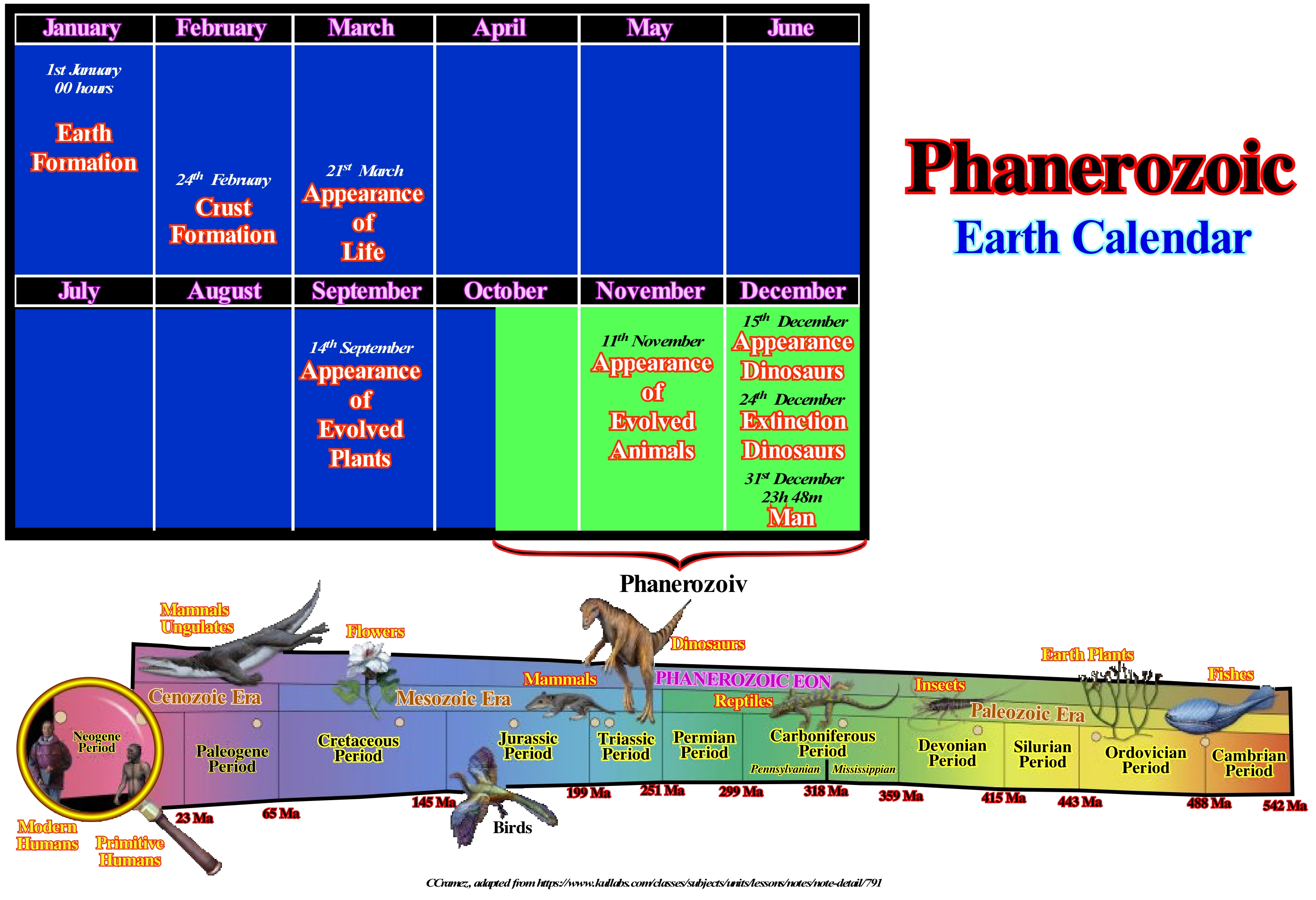
If the Earth's age was one year, as illustrated in this calendar, the Phanerozoic would have begun between April and the end of December. The dinosaurs would have appeared on 15th December and disappeared on 24th December while the Man would have appeared on 31st December at 11:30 pm, which means that the history of mankind would correspond to just 12 minutes. The Phanerozoic that is formed by three eras: (i) Paleozoic ; (ii) Mesozoic and (iii) Cenozoic, had begun, in this calendar, in mid-October. The Paleozoic is the longest and most diverse Era. It extends from the time of multicellular life (in the oceans) to the period of tetrapods, reptiles and large forests. The Early Paleozoic is the time of the invertebrates (Cambrian Explosion) and the appearance of the main groups of organisms, while the continents, derived from the break-up of the Protopangea (Rodhinia*) supercontinent, began to move away from each other. The Middle Paleozoic is the time of the fish and the diversification of invertebrates and also the displacement of life to the continent. The Late Paleozoic is the time of the tetrapods, reptiles. The forests of lycopods*, Calamites**, Rhodophytes*** and ferns are dominant. The continents began to coalesce. The southern part of Gondwana was covered with ice. Reptiles conquer the continent. The Mesozoic is the time of the reptiles (Dinosaurs). The weather conditions are tropical. The Pangea fractured and the continents began to move away from each other. Shallow seas covered a large part of the continents. The mammals were small and mostly nocturnal. The groups of modern organisms appeared. Vertebrate animals (mammals, birds, dinosaurs) developed larger and more complex brains than their ancestor reptiles. The Cenozoic is the time of mammals. During this period, after the extinction of dinosaurs, mammals evolved from small nocturnal animals to present types, as well as to the different prehistoric forms that have disappeared. The continents have acquired, more or less, the form they have today. The climate, initially tropical, changed little by little. The seasons become more marked with the development of glaciations, probably in association with the Himalayan uplift.
(*) Rodhinia supercontinent (from Russian "rodit"= growth was formed around 1.1 Ga as a result of the Grenville orogeny. The Rodhinia central part, on the equator, was occupied by Laurentia (North America and Greenland), surrounding Amazonia flanked by West Africa, Baltica, Siberia and the Indian craton Indian associated with four Australian cratons and the Chinese craton. After the Rodhinia break-up, between 600 and 560 Ma was reconstituted an ephemera Pannotia supercontinent Pannotia which, later, burst to form Laurentia and Siberia, then Baltica around 540, at the very end of the Proterozoic opening the Iapetus ocean.
(**) Genus of Lycopodiophyta, which is a division of vascular plants of the Kingdom Plantae. It is the oldest vascular plant division that still exists. It includes some of the most primitive existing species. These species reproduce by dispersion of spores and have alternation of macroscopic generations, although some are homo-spores while others are heterospores. They differ from all other vascular plants because they have micro-foliage, leaves that have a single vascular vein rather than the many that have the most complex megaphilic found in ferns and seedlings. There are three main groups in the Lycopodiophyta division, sometimes separated at the order level and sometimes in the class. (https://educalingo.com/en/dic-pt/licopodio)
(***) Calamites is a genus of arboreal Equisetophyta known for its fossil remains found in the sedimentary rocks of Devonian to Middle Permian.
(****) Pteridophytes are a group of seedless vascular plants with the corm composed of root, stem and leaves.
Phase Velocity (Wave).....................................................................................................................................................................Vitesse de phase
Velocidade de fase / Velocidad de fase / Phasengeschwindigkeit / 位相速度/ Фазова швидкість / Velocità di fase/
Rate at which the phase of a wave propagates in space. The speed at which a point characterized by a given phase in a simple periodic wave (which repeats in equal time intervals) moves in space.
See: « Fair Weather Wave Base »
Photic Zone.............................................................................................................................................................................................................Zone photique
Zona fótica / Zona fótica / Euphotische Zone / 真光层 / Эвфотическая зона / Zona eufotica /
Water column of an ocean or lake where there is sufficient light for photosynthesis. Although this zone, also called the euphotic zone, is defined in terms of light and not in terms of depth, it can be said it seldom exceeds 50-100 meters in depth. Synonym with Euphotic Zone.
See: « Shelfal Accommodation »
&
« Euphotic Zone»
&
« Disphotic Zone »
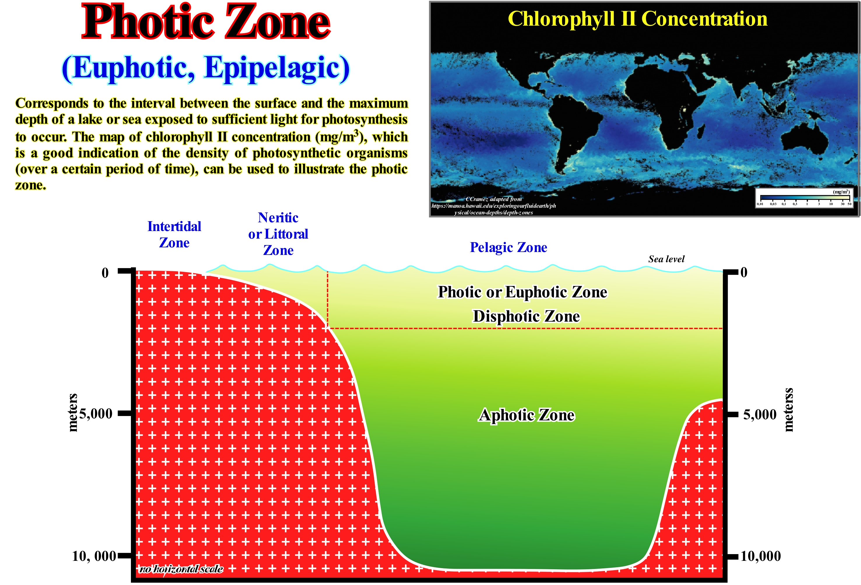
The photic or euphotic zone, also called the limnetic zone, is the water column where there is sunlight so that photosynthesis, is the volume of water where the rate of photosynthesis can be realized, that is, the water-depth where the rate of photosynthesis is greater than the respiration rate of the phytoplankton (a set of microscopic aquatic organisms that have photosynthetic capacity and which live scattered floating in the water column and which are transported by streams and water-bodies). Photosynthesis occurs in green plants and photosynthetic bacteria through a series of biochemical reactions. In evolved plants and algae, light absorbed by chlorophyll "c" catalyses the synthesis of carbohydrates (C6H12O6) and oxygen (O2) from CO2 and OH2. One of the most abundant components of phytoplankton is diatoms**, which sometimes form colonies, and dinoflagellates (a group of flagellate protists that belong to marine plankton but are also common in freshwater, such as Paramecium and Vorticell), which sometimes appear in large concentrations that form the so-called "red tides", which are often toxic. Phytoplankton plants are the first producers to use solar energy as a source of food. The compensation point, where photosynthesis equals respiration, marks the lower limit of the photic zone. Above the point of compensation, the phytoplankton population grows rapidly because there is plenty of sunlight to withstand a rapid rate of photosynthesis. Under the compensation point, the intensity of sunlight is very low and the phytoplankton respiration rate is faster than the rate of photosynthesis, which prevents the phytoplankton from surviving. The phytoplankton zones of the oceans and lakes are, extremely, important because phytoplankton, which is the first producer on which the rest of the food chain depends, is concentrated in these areas. Because photosynthesis is a process by which sunlight and CO2 are converted into food (chemical energy contained in carbohydrates) and O2, it creates about 90% of Earth's O2. Most of this oxygen is produced by phytoplankton. These early carbohydrate producers, called autotrophs (living things that produce their own food from the fixation of carbon dioxide through photosynthesis or chemosynthesis), are the first link in the food chain in the oceans. That is why many animals live in the euphotic zone. Most of the life in the oceans is found in this area, although it is the smallest area in terms of volume of water. The living beings of an ecosystem can be autotrophs or heterotrophs (which feed on organic substances made by others). Most autotrophs (algae, vegetation and certain bacteria) photo-synthesize. The animals, fungi***, protozoa and most bacteria are heterotrophs. They need to get food (organic substances) from other living things or their products. Most of the animals living on the seabed live in the euphotic zone, since it is defined in terms of light rather than depth.
(*) Physical-chemical process, at the cellular level, carried out by living beings with chlorophyll, using CO2 and OH2, to obtain C6H12O6, i.e., glucose, through the energy of sunlight, according to the following equation: Sunlight +6CO2 + 12H2O ➞ 6O2+ 6H2O + C6H12O6, i.e., the biological conversion of light energy into chemical energy.
(**) Diatoms are an important group of protists (a diverse group of eukaryotic organisms, which have a cell nucleus surrounded by a membrane, which includes most organisms that do not fit into any of the other two kingdoms (Animalia and Plantae) belonging to the division Bacillariophyta, according to the system of Round et al., (1990), are unicellular organisms and have as characteristic a carapace or siliceous wall called frustule, located outside the plastic membrane, occurring in fresh water and in the seas, being planktonic or benthic There are some species that form simple chains or colonies that may lead an observer to consider them as multicellular.. (https://pt.wikipedia.org/wiki/Diatomácea).
(***) Fungi (molds, yeasts, truffles, mushrooms, etc.) form a very large group (about 200,000 species) spread by practically any kind of environment. They have a wide variety of ways of life. They may live as (i) Saprophagous, when they obtain their food by decomposing dead organisms ; (ii) Parasites, when they feed on substances that they remove from living organisms on which they are established, harming them or being able to establish mutual associations with other organisms, both of which benefit. In addition to these more common modes of life, there are some groups of fungi considered predators that catch small animals and feed on them. (http://www.sobiologia.com.br/conteudos/Reinos/biofungos.php).
Photoautotroph (Organism).........................................................................................................Photo-autotrophique (Organisme)
Fotoautotrófico / Photoautotrofico (carbono del dióxido de carbono) / Photoautotroph (Kohlenstoff aus Kohlendioxid) / Photoautotroph(二氧化碳中的碳) / Фотоавтотрофный / Photoautotroph (carbonio da anidride carbonica) /
Organism that performs photosynthesis. Photoautotroph organisms use the energy of sunlight, carbon dioxide and water, which are converted into organic materials to be used in cellular functions, such as: biosynthesis and respiration.
See : « Photoheterotroph »
&
« Photosynthesis »
&
« Cyanobacteria »
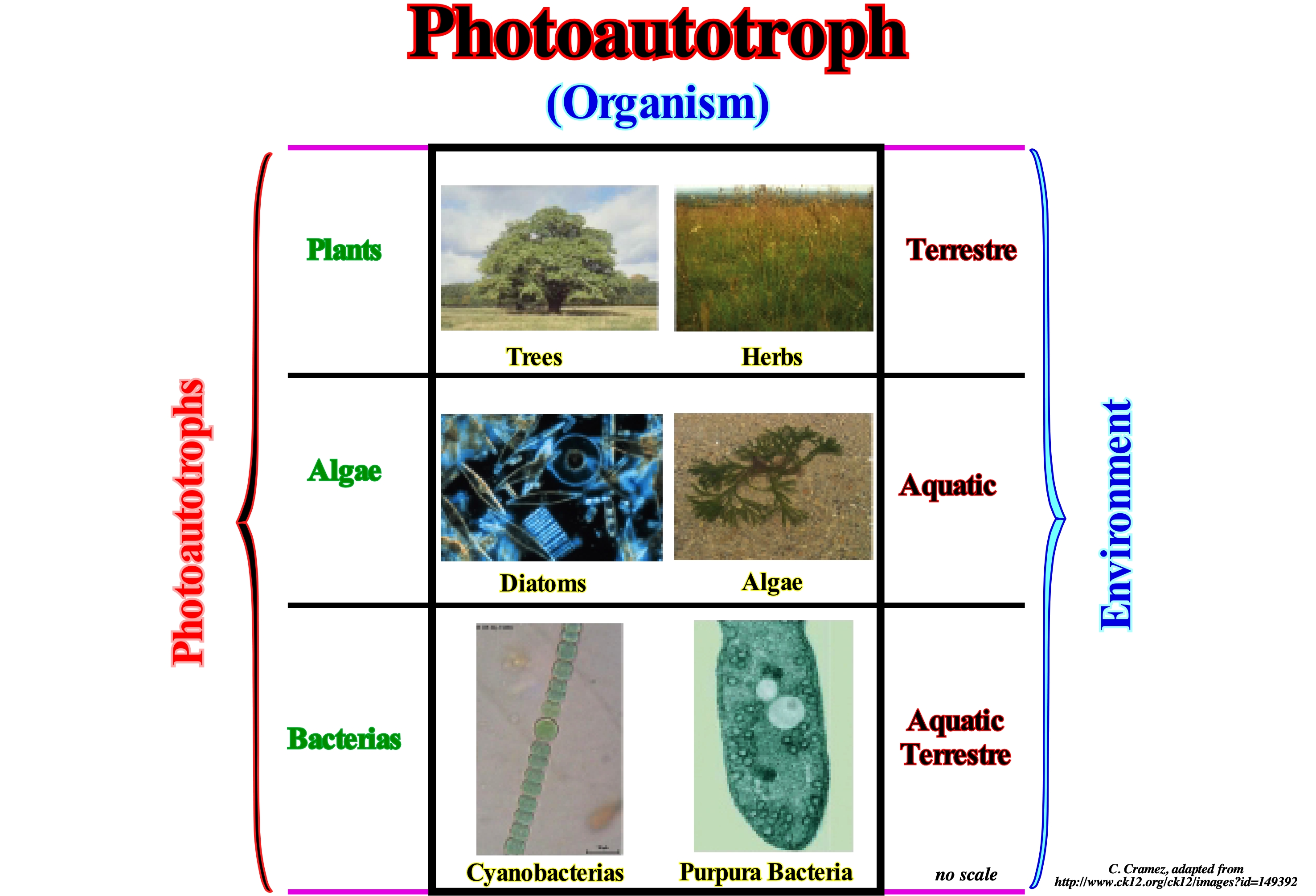
An autotroph is an organism capable of making its own food. In an ecological context, the photoautotroph organisms (that carry out the photosynthesis) provide nutrition for all the other life forms (besides others, autotrophs like, for example, chemotrophs). Photosynthesis uses the energy of light to synthesize biomass from inorganic precursors, while releasing oxygen. Photosynthesis has created and sustains our breathable atmosphere, the food we eat and the environment we need. In terrestrial environments, plants are the predominant variety, while aquatic environments include a wide variety of phototrophic organisms, such as algae, protists, bacteria, and so on. Photoautotrophs organisms must balance their excitation of capture with the consumption of metabolic energy in face of fluctuations in light, temperature and nutrients in a wide interval of time scales. Organisms need short-term responses to tolerate such fluctuations, but also require strategies to integrate signals from the environment over time in order to regulate the synthesis of abundant protein complexes for light capture, electron transport and biosynthesis. Variations of CO2 in the atmosphere, ultraviolet rays, nutrient cycles and temperature make it imperative to assess the ability of acclimatization of photosynthetic organisms that sustain ecosystems in interaction with natural constraints. Chemotroph organisms get energy through the oxidation of donor electrons in their environments. These molecules can be organic (organotroph) or inorganic (lithotroph). The designation of chemotrophs (organisms whose metabolism takes place without the presence of oxygen being therefore anaerobic) contrasts with phototrophs, which use solar energy. The chemotroph organisms may be autotrophs or heterotrophs.
Photoheterotroph (Organism)..................................................................................................................................Photo-hétertróphique (Organisme)
Foto-heterotrófico / Fotoheterotrofico (fuente de carbono a partir de compuestos orgánicos) / Photoheterotroph (Kohlenstoffquelle aus organischen Verbindungen) / Photoheterotroph(从有机物的碳源)/ Фотогетеротрофный / Fotoheterotrofe (fonte di carbonio da composti organici) /
Organism that depends on light for the most part its energy and, mainly, on the organic components for its carbon. Photo-heterotrophic organisms are unable to convert carbon dioxide to sugar or produce oxygen.
See: « Photosynthesis »
&
« Photoautotroph »
&
« Cyanobacteria »
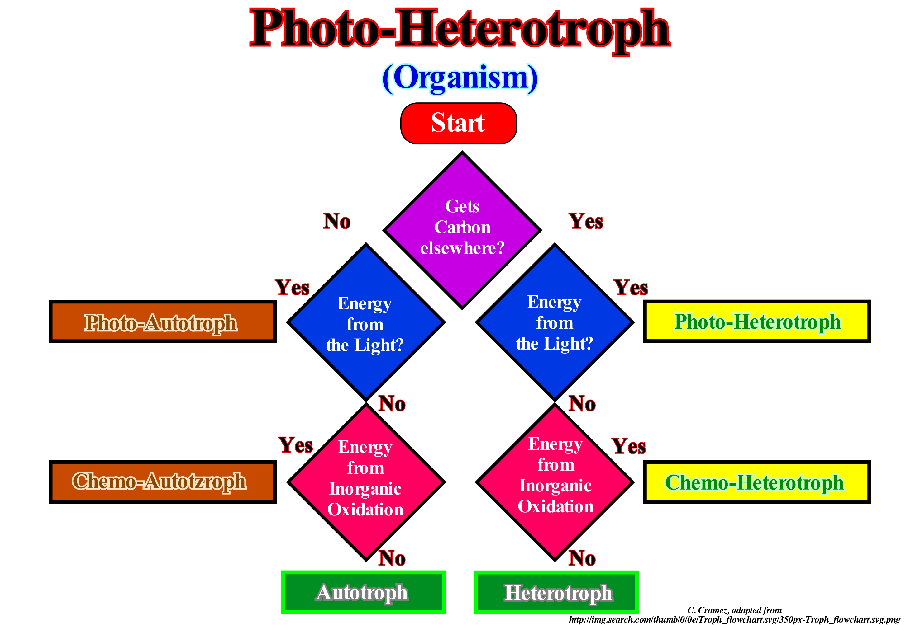
Photoheterotrophs are heterotroph organisms (which use organic carbon for growth by consuming other organisms) that use light as energy but can not use carbon dioxide (CO2) as their only source of carbon. They use organic compounds from the environment to meet their carbon needs. These organisms use compounds such as carbohydrates, fatty acids and alcohols as organic food. Examples of photoheterotrophs are purple sulfur bacteria, sulfurous green bacteria and heliobacteria. Photoheterotrophs can be said to be organisms that combine aspects of the metabolism of phototrophs and heterotrophs. Phototrophs get their energy from light and carbon dioxide (CO2) (photoautotrophy), producing organic material. The other elements required for growth (nitrogen and phosphorus, for example) generally come from inorganic sources, such as ammonium (NH4) and phosphate (PO43-). Examples of phototrophs include plants on land whereas in the oceans, the major phototrophs are microscopic algae (phytoplankton). Similar to terrestrial plants on land, phytoplankton forms the basis of the food chain from which other marine organisms depend. Heterotrophs obtain their energy (chemoorganotrophy) and the carbon of organic matter, producing CO2 in the process. In the oceans, the largest heterotrophs include fish and whales, but small heterotrophs, such as bacteria and other microbes, are the most important and use the organic matter produced by phytoplankton (primary production) for their energy and carbon. The heterotroph bacteria and the small herbivorous protists who eat them consume about 50% of the primary production of the oceans. This process is important in determining the size and fluxes of dissolved organic matter (DOM) in the oceans, which include dissolved organic carbon (DOC). The amount of carbon in the DOC oceans is, approximately, equal to that of carbon in atmospheric CO2.
Photosynthesis.............................................................................................................................................................................................Photosynthèse
Fotossíntese / Fotosíntesis / Photosynthese / 光合作用 / Фотосинтез / Fotosintesi clorofilliana /
Fixation of carbon by green plants under the action of sunlight. The light energy* is converted into chemical energy and stored in the form of sugar. Photosynthesis occurs in plants and some algae (Protista Kingdom). Green plants need only the energy of light, CO2 and H2O to make sugar. Photosynthesis occurs in chloroplasts, specifically through chlorophyll.
See: « Organic Matter (types) »
&
« Epifauna »
&
« Cyanobacteria »
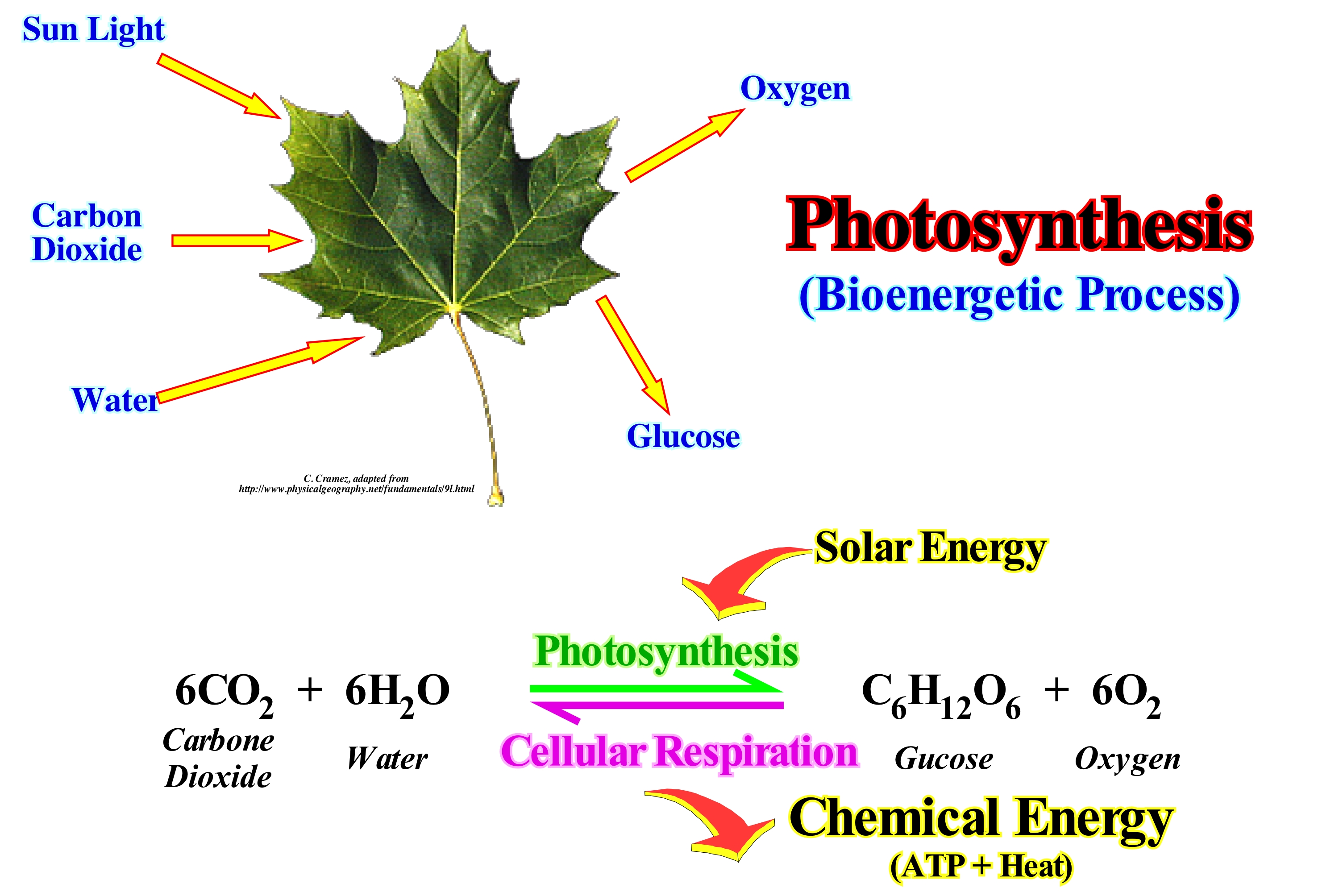
Photosynthesis is the process by which plants, some bacteria and some protists use the energy* of sunlight to produce sugar, which cellular respiration converts to ATP ** - the "fuel" used by all living things. The conversion of solar energy into usable chemical energy is associated with the actions of the green chlorophyll pigment. The photosynthetic process uses water and releases the oxygen that is, absolutely, necessary to keep us alive. The chemical reaction of this process can be written as follows: 6CO2+ 6H2O----------> C6H12O6 + 6O2, i.e., that six water molecules plus six molecules of carbon dioxide produce a molecule of sugar and six molecules of oxygen. Plants are the only photosynthetic organisms that have leaves (not all plants have leaves). The leaves can be seen as solar collectors filled with photosynthetic cells. The raw materials of photosynthesis, water and CO2 enter the cells of the leaves and photosynthesis products, sugar and oxygen, leave the leaves. Water enters the roots of plants and is transported to the leaves through specialized cells known as xylem (tissue transporting water and minerals through the plant body). Because terrestrial plants must guard against dehydration, they have special structures, that is, stomata to allow the gas to enter and leave the leaves. CO2 can not pass through the protective waxy layer that covers the sheet (cuticle, wax cover produced solely by the epidermal cells of the sheets), but can enter the sheet through the openings (stoma), which are flanked by two protective cells. Oxygen produced during photosynthesis can only pass out of the sheet through open stomata. As these gases move between the inside and outside of the leaves, a lot of water is lost. CO2 enters the aquatic cells and autotrophs by non-specialized structures.
(*) Energy is the ability to do a work. There are two types of energy, the kinetic energy, that is, the ability to do work through the movement and the potential energy, that is to say, the ability to do work through the position. Although we often meet terms such as electrical energy, chemical energy, nuclear energy such things do not really exist. They are only practical abbreviations for specific combinations of the kinetic energy and potential energy. Thus, the electrical energy is only the potential energy of negative charge electrons in the presence of positive charges. The exception to this universality of the kynetic energy and potential energy is the energy of electromagnetic radiation, such as the energy of light, such as the one transported from the Sun to Earth and which heats us or aliments photosynthesis. (P. Atkins, 2003)
(**) Adenosine triphosphate (ATP) is a fundamental nucleoid in the production of cellular energy, which is formed by a nitrogenous base (adenine) attached to the carbon 1 of pentose type sugar, ribose, that in its carbon 5 has three phosphate groups bound. It is the main source of energy for most cellular functions. (https://es.wikipedia.org/wiki/ Adenos%C3%ADn_ trifosfato)
Phreatic Level (Hydrologic cycle)..................................................................................................................................Niveau phréatique
Nível freático / Nivel freático / Phreatisches Niveau / 潜水水平 / фреатическое уровень / Livello freatica /
Upper level of an aquifer, in which the water pressure equals atmospheric pressure. Under the watertable, the soil is saturated with water, i.e., all intervals between the grains are full of water, which is not the case above the watertable.
See: « Sabkha »
Phylozone..................................................................................................................................................................................................................................Phylozone
Filozona / Filozona / Phylozone (Schichten repräsentieren einen evolutionären Abstammung) / Phylozone(地层演化谱系) / Зона родословной / Phylozone (gli strati che rappresentano una linea evolutiva) /
Set of strata containing specimens representing a specific segment of the evolutionary lineage, which may represent the entire scale of a taxon within a lineage or only part of the taxon scale. A taxon or taxonomic unit is the name assigned to an organism or group of organisms which according to C. Linnaeus reflects a certain level in the hierarchy of evolution. Synonym with Lineage Zone.
See: « Facies »
&
« Fossil »
&
« Biostratigraphy »
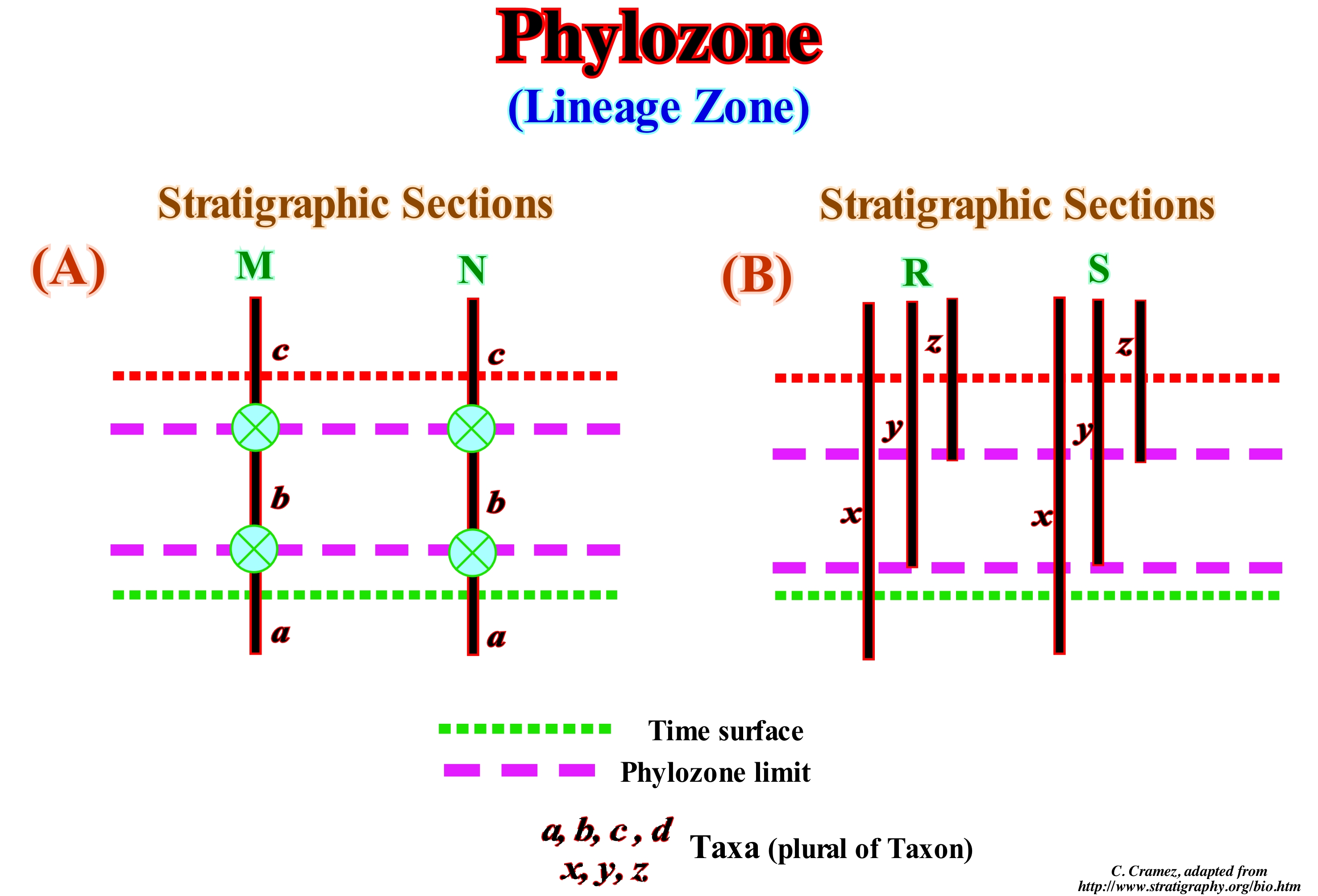
Biostratigraphic units or biozones are sets of strata, which are defined or characterized on the basis of the fossils, which they contain. The stratigraphic units exist only where the elements that characterize them or certain attributes on which they are based can be identified. It can be said the biostratigraphic units are based on the identification of the fossils and that they differ from the other types of stratigraphic units because the fossils show changes through geological time, which are not repetitive in the stratigraphic record. In this figure, the stratigraphic sections M and N (A), the phylozone or lineage zone represents the entire taxon* "b", from the occurrence of its ancestor, taxon "a" , to the lowest occurrence of its descending taxon "c". In the stratigraphic sections R and S (B), the lineage zone represents the part of the zone of the taxon y between its oldest occurrence and the oldest occurrence of its descendant, taxon "z*. The boundaries of a lineage zone are almost coincident with the boundaries of the chronostratigraphic units, that is, of the stratigraphic surfaces or interfaces are synchronous (which have the same age everywhere). A lineage zone differs from a chronostratigraphic unit since it is restricted, like all biostratigraphic units, to the actual spatial distribution of fossils. Phylozones permit, actually, correlations in relative time more likely than those obtained by biostratigraphy, which is responsible for ordering the succession of sedimentary rocks based on their paleontological content. The name of phylozone has the name of the taxon whose distribution it expresses. The typical site of phylozone is the name of the place where the taxon is well represented and where the geological context is clearer. Do not forget that taxon is the group of (one or more) organisms that a geoscientist (taxonomist) thinks is a unit and that the plural of taxon is taxa.
(*) Unit that defines the groups of biological organisms, based on common characteristics and gives names to these groups, essentially, associated with a classification system. The taxon can indicate a unit at any level of a classification system. A kingdom, genus and a species are taxa as well as any other unit of a classification system of living beings.
Physiographic (Province).....................................................................................................................................Physiographique (Province)
Fisiográfica/ Fisiográfica (província) / Physiographischen (Provinz) / 自然地理(省) / Физико-географическая (провинция) / Fisiografici (provincia) /
Morphological region delimited according to similar terrain that was modeled by a common geological history. Each physiographic province is characterized by a certain altitude, relief, lithology and geological structure. Function of the region's history, deformations and erosion, different morphologies or other geological features can be highlighted within the same province.
See: « Continental Platform »
&
« Sedimentary Environment »
&
« Bayline »
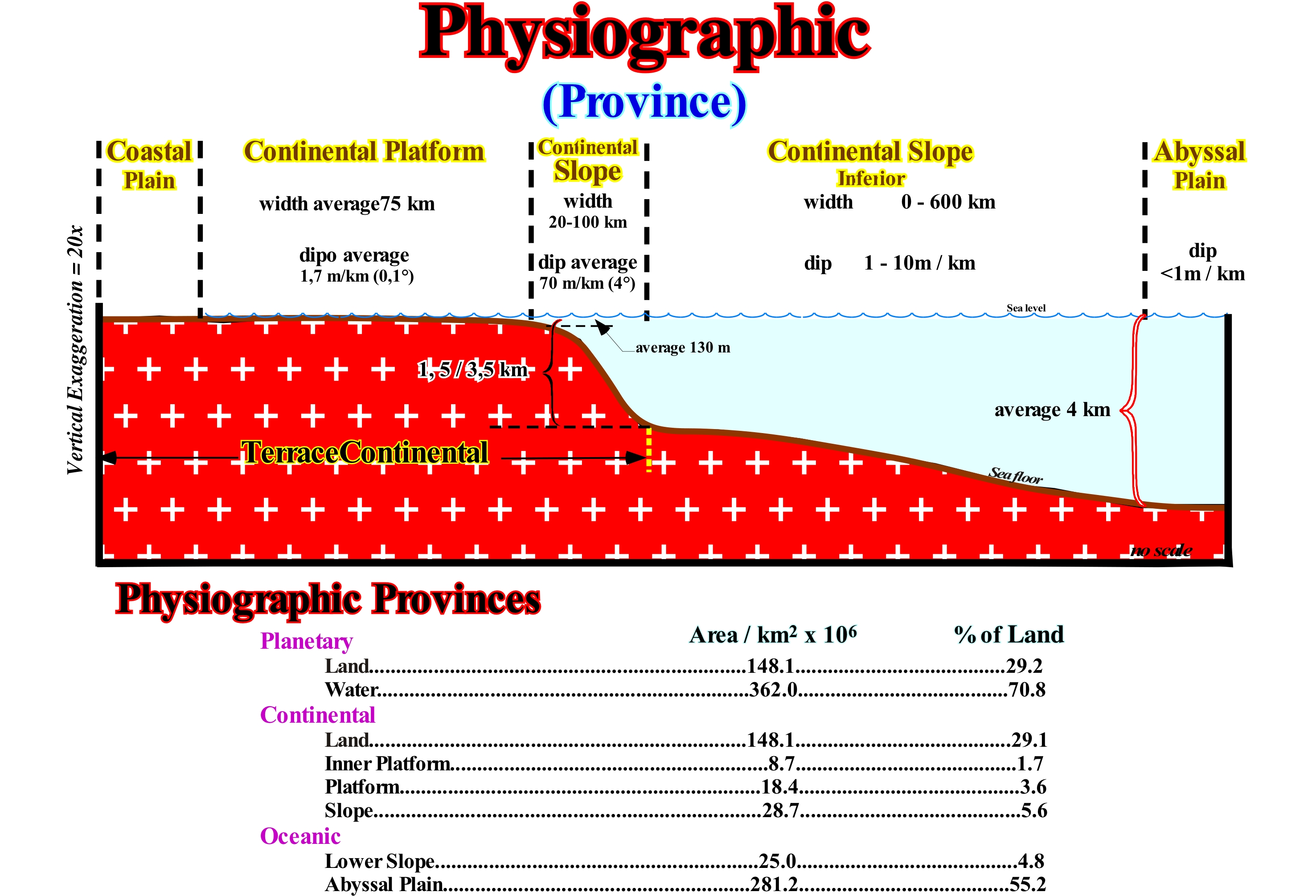
As illustrated in the sketch of this figure, from the continent to the deep sea, the main physiographic provinces are: (i) Coastal Plain ; (ii) Continental Platform (shelf) ; (iii) Continental Slope ; (iv) Lower Continental Slope and (v) Abyssal Plain. The first three first, i.e., the coastal plain, continental shelf and continental slope form the Continental Terrace. Many geoscientists speak only of continental terrace, lower continental slope and abyssal plain. Depending on the position of the sea level and therefore the shoreline, which separates the offshore from the onshore, the continental shelf may not exist, which is very important, especially, in sequential stratigraphy. When the geological conditions are highstand, i.e., when the sea level is higher than the basin edge, the basin has a shelf. This is what occurs in a sequence-cycle during the sedimentary systems tracts subgroups known as the transgressive interval (IT) and highstand prograding wedge (HPW), particularly during the 1st phase of its development (subgroups of the highstand systems tracts group). In fact, at the beginning of deposition of the highstand prograding wedge (HPW) of a sequence-cycle, the shoreline is very far upstream of the continental edge, which means that the basin has a shelf. However, as the relative sea level (resulting from the combined action of the tectonics and absolute or eustatic sea level, which is supposed to be the global and referenced to Earth's centre), i.e., due to a marine ingression or ever-smaller eustatic paracycles, progressively, the shoreline approaches the continental edge reducing the extent of the shelf. Since the shoreline coincides with the continental edge, i.e., as long as the outer limit of the coastal plain coincides, roughly, with the continental edge, the basin no longer has a shelf and the geological conditions, practically, become of lowstand with the basin edge coincident with the continental edge. If the relative sea level falls further, a limit develops (unconformity), since geological conditions become truly lowstand with the sea level lower than the basin edge (the last continental edge of the preceding sequence-cycle, i.e., before the significant relative sea level fall responsible from the unconformity which emphasizes the in geological conditions change). As illustrated in this sketch, the different physiographic provinces are limited by slope breaks of the depositional surface: (i) The alluvial plain (not shown in this scheme) is limited downstream by the slope break of the bayline, which separates fluvial deposits (upstream) of fluvial/coastal deposits (influenced by relative changes in sea level) ; (ii) The coastal plain is limited between the bayline and the depositional coastal break (roughly the shoreline) ; (iii) The continental shelf, limited between the depositional coastal break and the continental edge break, has an average width of 75 km, an average slope of 0.1° (± 1.7 m/km) and an average water-depth of 130 meters ; (iv) Upper continental slope, limited between continental edge break and lower continental slope break, has a width ranging from 20 to 100 km and an average slope of 4° (± 70 m/km) ; (v) Lower continental slope, limited between the lower continental slope break and the abyssal plain break, has a width ranging from a few meters to more than 600 km and an average slope between 1 and 10 m / km and (vi) The abyssal plain, limited upstream by the abyssal plain break, generally, has a water-depth of more than 4,000 meters and a slope of less than 1m/km. It is important not to forget that the continents represent 29.2% (148.1 x 10⁶ km2) of the Earth and the water, in all its forms, represents 70.8% (362 x106 km2) of the Earth. The platform represents 5.3% (27.1 x 10⁶ km2) of the Earth, the continental slope 5.6% (28.7 x 10⁶ km2) and the abyssal plain 55.2% (281.1 x 10⁶ km2). Much of the Earth's water is either salty or inaccessible to man. Only 3% is sweet, of which only 32% is not icy (ground water about 30% and surface water about 2%). The distribution of water on Earth is as follows: (i) Oceans, 1,350 x 1015 m3 (97.3% of the total water) ; (ii) Cryosphere, 29 x 1015 m3 (2.1%) ; (iii) Underground, 8.4 x 10¹⁵ m3 (0.6%) ; (iv) Lakes and Rivers, 0.2 x 10¹⁵ m3 (0.01%) ; (v) Atmosphere, 0.013 x 10¹⁵ m3 (0.001%) and (vi) Biosphere, 0.0006 x 10¹⁵ m3 (4 x 10⁻⁵ %).
Phytobenthos.......................................................................................................................................................................................................Phytobenthos
Fitobentos/ Fitobentos / Phytobenthos / Phytobenthos (水产) / Фитобентос / Fitobentos /
Aquatic flora that lives on or near the bottom of the sea, in particular, in shallow and intratidal waters.
See: « Benthos »
&
« Merobenthos »
&
« Tide »
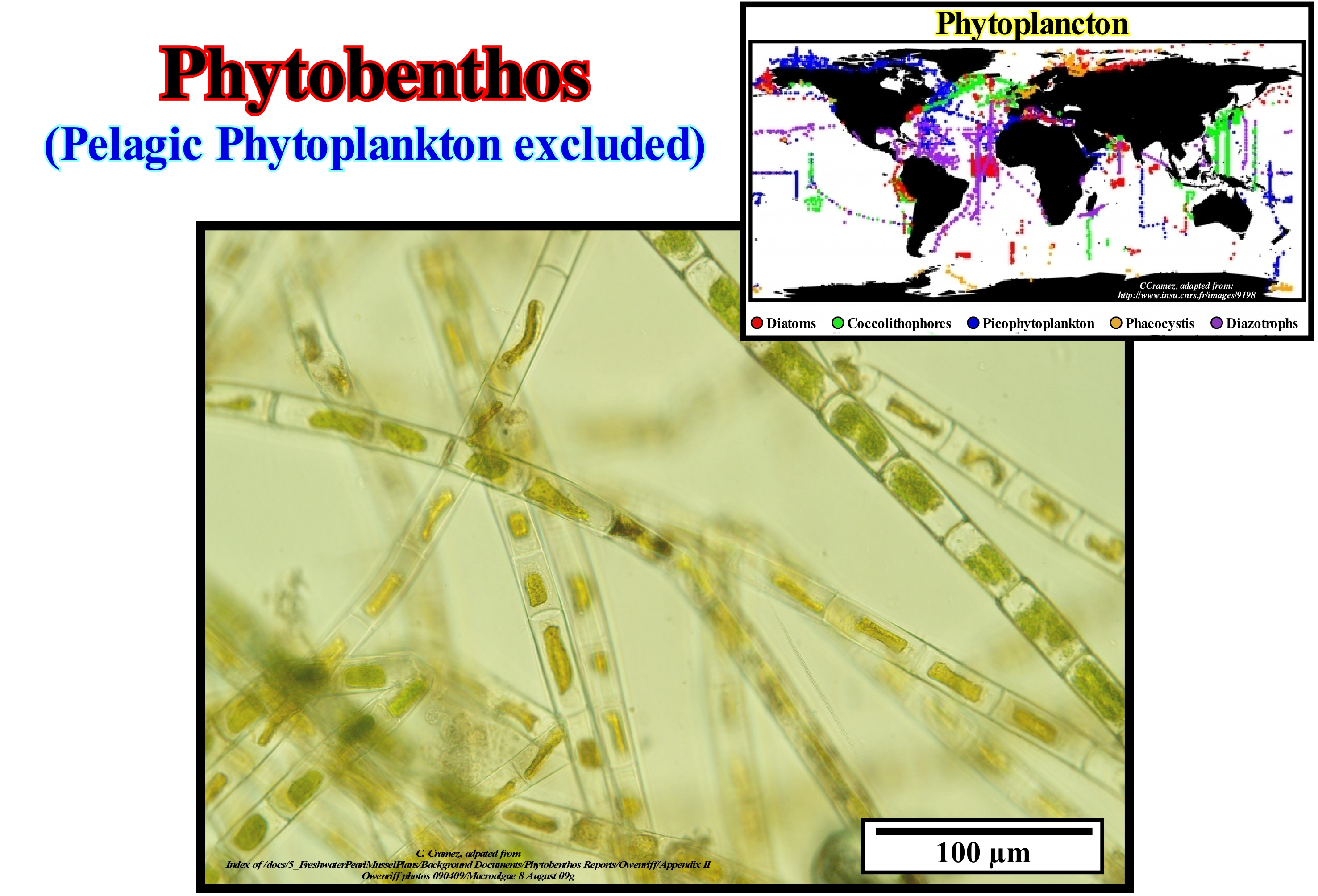
Phytobenthos is synonymous with aquatic flora, whether fresh or salt water. Phytobenthos are benthic and not pelagic. Pelagic phytoplankton is excluded from phytobenthos. Algae, aquatic plants, plants with marine flowers belong to phytobenthos. Phytoplankton (a set of microscopic aquatic organisms that have photosynthetic capacity and that live scattered floating in the water column) is an indicator of the nutrient pressure in the waters. Phytobenthos (particularly benthic diatoms) respond to changes in water quality characteristics due to the characteristic backwardness of species forms and abundance and provide information on: (i) Nutrient pressure ; (ii) The pressure of the salt ; (iii) Saprobiontic (organisms which feed by absorbing decomposing organic substances) and (iv) The acidity of water*. Aquatic macrophytes (aquatic plants that live from flooded terrain to truly aquatic environments, including freshwater, brackish and saline bodies) can also be used to assess nutrient pressure in rivers. They also react to hydrological regime interventions (potamalization**, water retention) and reflect the morphological conditions of the watercourse (substrate diversity and dynamics, degree of rigid development of the banks and the river bed). The macrozoobentos (benthic invertebrates) are an indicator of the water quality and the hydromorphological conditions through the composition of species, the relations of domination and the presence of neozoaria (animals, which since the beginning of modern times, that is, more or less, after 1492, they entered with the direct or indirect participation of the man, in a faunistic zone that was not accessible to them before and where they established new populations). Species diversity, abundance and fish age structure are indicators of extensive morphological changes, continuity, changes in flow conditions (e.g., dams, taxes, diversions), heat and pressure. High water temperatures induce a faster mineralization of the organic matter and, therefore, effects of eutrophication***. As a result, the small currents of water have changed in character and resemble the great rivers ("potamization").
(*) The acidity of a water corresponds to the presence of free carbon dioxide, mineral acids and salts of strong acids and weak bases. However, most geoscientists consider it as it is, solely, because of the presence of carbonic acid.
(**) If cold-water streams are dammed, the warmer water in reservoirs might favour species adapter to warmer temperatures, resulting in a so-called potamalization effect, i.e., a shift from rhithral (describing a relatively fast stream, typically fed by melt-water) to potamal communities (Jungwirth et al. 2003). Potamal is a technical geographical term of limnology and hydrology of the lower stretches of a stream or river . It describes the overall habitat, stability and ecology of the biomass.
(***) Increase of nutrients (food that an organism needs to live and grow or of substances used by the body's metabolism, which are removed from the environment), usually nitrogen and phosphorus, occurring both on land and at sea. The term eutrophication is often used to designate an increase in the productivity of an ecosystem.
Phytoplankton................................................................................................................................................................................................Phytoplancton
Fitoplâncton / Fitoplancton / Phytoplankton / 浮游植物 / Фитопланктон / Fitoplancton /
Microscopic plants that live in the ocean, which are very important not only to the ocean but to the entire planet, since they are at the base of the food chain. Small fish and whales eat the phytoplankton. Small fish are eaten by larger fish and so on. The food chain continues and at one point we eat the fish, which means that the energy of the phytoplankton is the basis of our energy.
See: « Plankton »
&
« Photosynthesis »
&
« Organic Matter (types) »
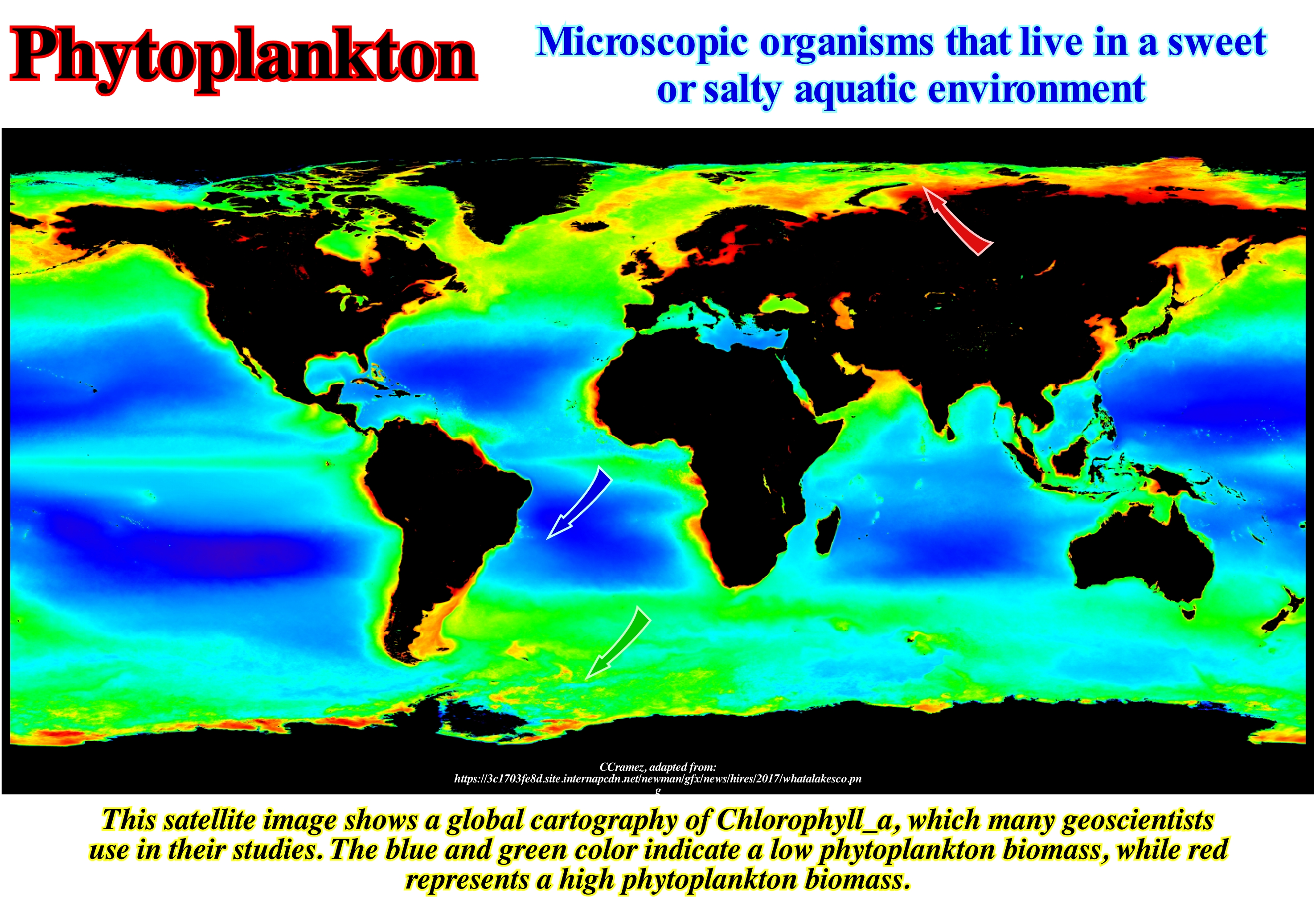
Phytoplankton is the set of microscopic aquatic organisms that have photosynthetic ability and that live dispersed floating in the water column. They are part of this group of organisms, traditionally considered algae and studied as such in botany, more specifically in phycology (discipline of biology that studies algae). However, among these, there is a group of great sanitary and public health importance, which is also classified as bacteria, that is, cyanophytes or blue algae. The differences in the classification of organisms belonging to this group are due to the fact that they have characteristics of plant cells (presence of chlorophyll in chloroplasts and cell wall with cellulose) and of bacteria (nuclear material dispersed in the cytoplasm). Currently, blue algae or cyanobacteria, most commonly used name, are limited by environmental legislation for drinking water, because some strains produce toxins (cyanotoxins) that may be lethal to mammals. Other organisms belonging to phytoplankton are also classified in several clades of the Protista, as some flagellates and ciliates with capacity to carry out photosynthesis and, particularly, organisms of the class Euglenophyceae. Several genera, such as Euglena spp. are facultative photosynthetic, i.e., in the absence of light they can survive as a heterotroph being. In current waters (rivers and streams) the most important group, due to their abundance and diversity, is the diatoms, microscopic organisms with yellow-gold pigments and external shell of silica, which protects the cells from the mechanical aggression caused by the current. In lakes and dams the algae of the Chlorophyceae class are more diverse and abundant. They have structures that favour buoyancy, yet they are fragile. In this group there are algae of great beauty.
Picoplankton............................................................................................................................................................................................................Picoplancton
Picoplâncton / Picoplancton / Pikoplankton (Zellen zwischen 0.2 und 2 μm) / 微微型浮游生物 (0.2和2μm之间的细胞)/ Пикопланктон / Picoplancton (celle comprese tra 0,2 e 2 micron) /
Fraction of plankton composed of cells between 0.2 and 2 micrometers (μm). The microplankton can be: (i) Photosynthetic (composed of organisms that use photosynthesis to grow) and (ii) Heterotrophic (composed of organisms that use carbon to grow). Certain species are mixotrophic, which is to say, organisms that can use various forms of energy and carbon.
See: « Plankton »
&
« Microbenthos »
&
« Meroplankton »
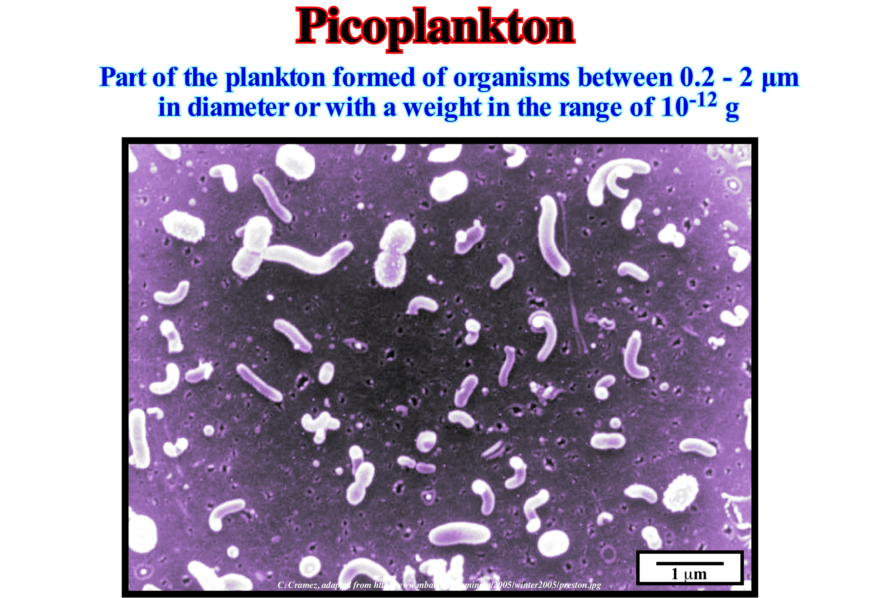
In marine biology and limnology is called plankton (from the Greek word planktos, meaning wandering) to the set of organisms that have little locomotion power and live freely in the water column (pelagic) being often dragged by the ocean currents. Plankton is often described in terms of size. Typically, the most commonly used divisions are as follows: (i) Megaplankton when the dimensions are greater than 20 millimeters, such as metazoans: jellyfish, ctenophores (comb jellies) are marine or estuarine, planktonics, some benthic and bioluminescent), salps (barrel-shaped, planktonic tunicates) and pyrosomes (Tunicata pelagic), cephalopods, etc. ; (ii) Macroplankton, when the dimensions vary between 2 and 20 millimeters, such as jellyfish, some ctenophores, salps , etc. ; (iii) Mesoplankton, when the dimensions vary between 0.2 and 2 millimeters, as the jellyfish, cladocerans (small crustaceans commonly called water fleas), ostracods, chaetognatha (from the Greek "jaws with thorns", are small marine animals about 15 cm in length, planktonic of elongated and non-segmented body, with lateral fins and caudals that are extensions of the ecloderme) ; (vi) Microplankton, when the dimensions vary between 20 and 200 μm, as the great protists eukaryotes, very phytoplankton, protozoa (foraminifera), etc. ; (v) Nanoplankton when the dimensions vary between 2/20 μm, such as small protists eukaryotes, small diatoms, small flagellates, etc. ; (vi) Picoplankton, when the dimensions vary between 0.2 / 2 μm, such as small protists eukaryotes, bacteria, etc., and (vi) Femtoplankton, when the dimensions are less than 0.2 μm, such as marine viruses. Plankton is at the base of the food chain of aquatic ecosystems, since it serves as food for larger organisms.
Piedmont......................................................................................................................................................................................................Piemonte, Piemond
Piemonte/ Piedemonte / Piedmont / 皮埃蒙特 / Предгорье / Piemonte /
Literally, it means the foot of the mountain. In geology, this term is used to denote a slightly sloping surface covered by a, more or less, coalescing alluvial cones complex in which the individual shape of each cone is, virtually, no longer recognized.
See: « Alluvial Fan »
&
« Alluvial Plain »
&
« Submarine Slope Fan »
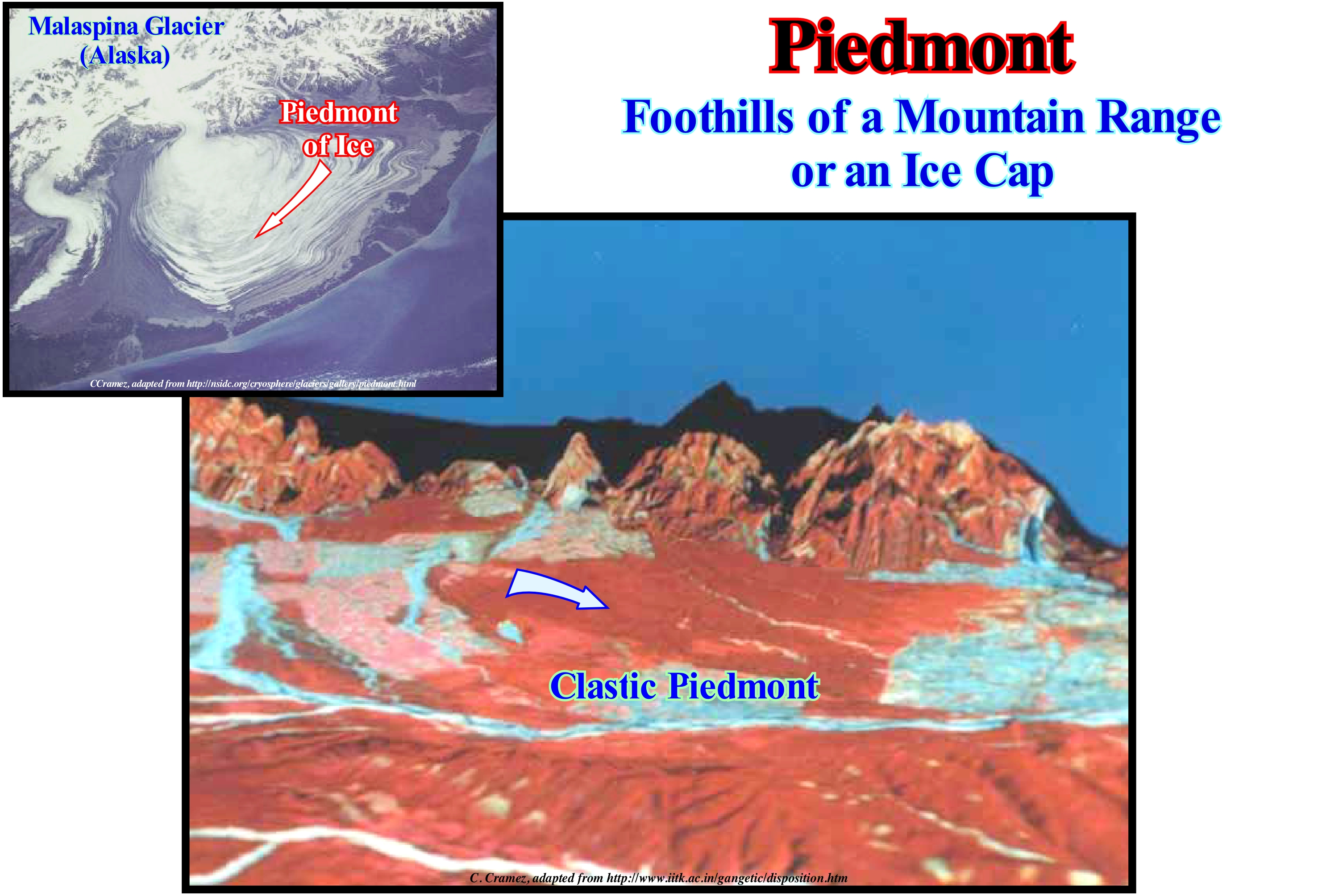
The piedmont area illustrated in this photograph, formed near the foothills of the Himalayas (valleys of Dehradum and Garhwal) and marks the northern limit of the Ganges plain. The typical topographic elements of this region (Bhabar) are the conglomeratic deposits molasses (Siwalik) and the plains (Tarai). Several examples of Piedmont areas have been described in this area (Uttranchal State, North India), particularly in the Doon Valley (Himalayan Garhwal) and in the Nainital (Himalayan Kumaon) region. The conditions of flooding at the base of the mountains, i.e., the conditions of formation of piedmont, vary according to the climate. Alluviation minimal in regions with continuous rains, since the waterways transport the sediments as they form (especially if they are made up of fine particles) and lead them, in great part, to the sea. It is mainly in the intramontane regions, that accumulation of the dejections (alluvial cones of the temperate regions). The flooding, on the other hand, is very strong in: (i) Mediterranean regions ; (ii) Continental areas where there are monsoons; (iii) Semi-arid regions and (iv) Regions with discontinuous coverage and compulsory rainfall. In the sub-desert regions, the accumulation of the alluvial cones is made on the pediments. Due to the great load of the water currents that leave the mountains, the great alluvium of piedmont deposit like alluvial cones on which the currents of water wander. This is the first phase of the evolution of an alluvial piedmont (called alluvial cones phase). The phase of the plateaus, which is the second phase is, generally, the result of a piedmont uplift (lowering of the base level or climate change). Alluvial fans are, partially, eroded to form plateaus (when stream incisions are rare) or elongate plains (when dissection is the result of every stream of water born in the piedmont). The final phase or third phase is, of course, the phase of the erosion plain, where everything has already been more or less flattened.
Piezometric Surface.............................................................................................................................................Surface piézométrique
Superfície piezométrica / Superficie piezométrica / Grundwasserdruckfläche / 测压面 / Пьезометрическая поверхность / Superficie piezometrica /
Surface to which water can reach under hydrostatic pressure. The level at which the hydrostatic pressure in an aquifer will be reached if it reaches a balance with the atmospheric pressure. For artesian wells, the piezometric surface is above the surface of the terrain.
See : « Juvenile Water »
&
« Hypogenic Water »
&
« Reservoir-Rock »
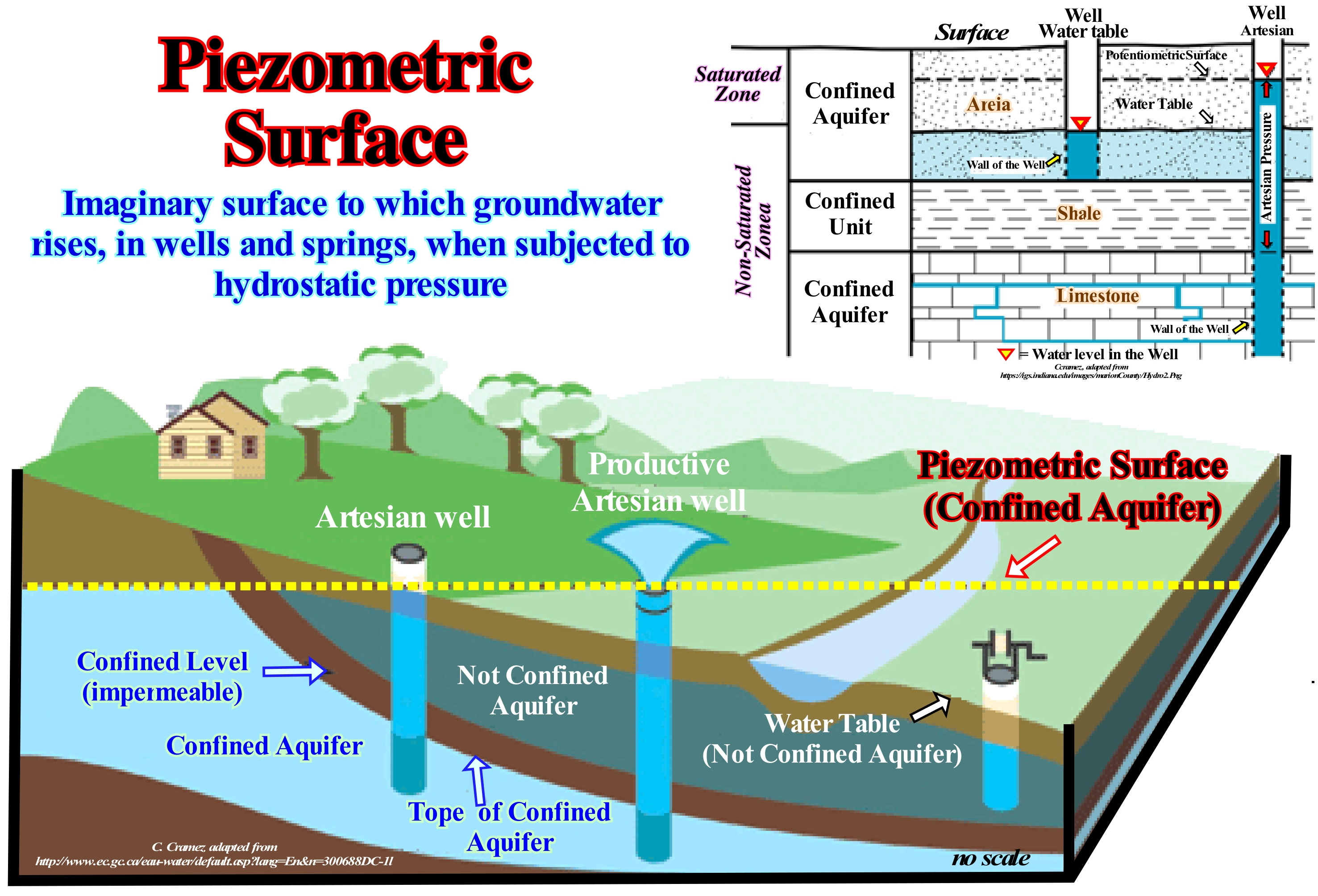
As shown the piezometric surface is the level at which the water's hydrostatic pressure in an aquifer is in equilibrium with the atmosphere. In artesian wells (when the water of a confined aquifer, that is, underlying an impermeable layer, naturally flows from the soil without the need for pumping) the piezometric surface is above the surface of the soil. In a semi-artesian well the water pressure is not enough to rise to the surface, which necessitates the installation of equipment inside the well to pump the water. Changes in soil water storage due to pumping and recharge are reflected by corresponding changes in the water-table and the height of the piezometric surface. Other factors affecting pumping, such as changes in barometric pressure (or atmospheric pressure) is the pressure exerted by the atmosphere at a given point. Ocean tides and groundwater use by plants also influence water levels. An appreciation of the water level fluctuations induced by these factors is necessary to avoid that the observed water levels are misinterpreted. The elevation of the piezometric surface in confined aquifers is indicated by the water-level in the piezometers (observation hole in aquifers that serve to monitor water levels in the aquifers and to identify the shape, extent and anisotropy of the kneading cone that forms around hole in extraction). It is important to know the piezometric level change associated with a change in atmospheric pressure. The increase in atmospheric pressure is transmitted directly to the surface of the water in the piezometer, tending to move the water from the piezometer to the aquifer. Increasing the pressure also increases the load on the aquifer, which tends to move the water from the aquifer to the piezometer. Part of the increase in charge appears in the aquifer, however, the basic result of increasing barometric pressure is a decrease in water height.
Piggyback Basin..............................................................................................................................................................................Bassin transporté
Bacia transportada / Cuenca transportada / Huckepack Becken / 盆地运 / Транспортируемый бассейн / Bacino trasportati /
Depression, more or less, stable behind the thrusts that form a mountains belt, when the basal lamina of the thrusts advances outward, that is to say, towards the craton. This type of shortening, in which the most distal thrust (relative to the orogen) is the younger, is known as "shortening in sequence."
See: « Sedimentary Basin »
&
« Foreland Basin »
&
« A-type Subduction (Ampferer) »
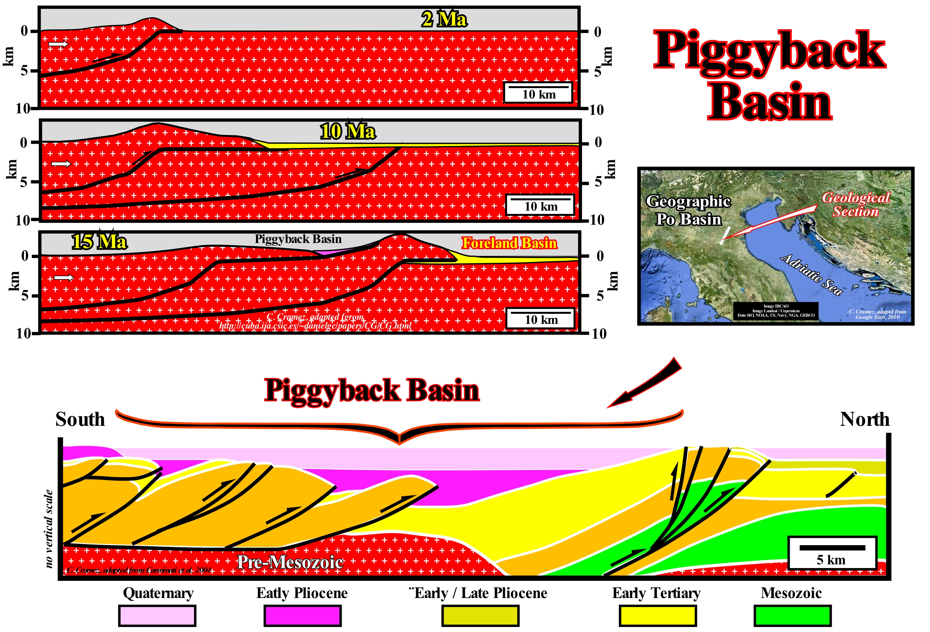
A set of thrusts formed in sequence entails a burial of the basal thrust, younger, as it spreads towards the craton (direction opposite mountain ranges belt). As illustrated in this figure, older thrusts, which gradually become inactive, are carried on the backs of more recent thrusts (upper faulted blocks of reverse faults, which underline the thrusts) forming piggyback basins. This type of structures can be modelled, mathematically, and reproduced in the laboratory. Using sand as an analogue material, which is, gradually, shortened (subjected to a compressional regime), it is easy to see that the basal (most recent) thrust advances due to the increased resistance of the material of the riding block, since its thickness increases in the opposite direction (towards the shortened areas). I can be said, that piggyback basins correspond to the stable depressions developed in the uprights slopes of the thrusts, when the basal thrust (frontal) advances towards the craton. In northern Italy, in the geographic Po River geographic basin (Quaternary), located in the foreland of the Apennines, the piggyback basins, as shown in this figure, are always upstream of the frontal thrust (the most recent). They fossilize the old thrusts, which are, more or less, inactive. Until about 1950, the subsidence of the coast of the Po river basin, induced by the evolution of the piggyback basins, was compensated, to a large extent, by the development of the Po Delta. Unfortunately, the anthropic change of certain geological factors, such as the sedimentation rate, degraded the delta and, as a consequence, the coast began to sink, creating enormous problems in the city of Venice, which is, likely, to be greatly affected, in the coming centuries, due to the relative sea level rise, mainly, induced and by the increase of subsidence. This rise of relative sea level (sea level referenced to any point on the Earth's surface as the top of the continental crust, i.e., the base of the sediments or the sea floor) has nothing to do with a rise of the absolute (eustatic) sea level (supposed global sea level, referenced to the Earth's centre), as suggested by a large part of the members of the environmental lobby. The piggyback basins are, practically, always present in the orogenic belts. They form and fill themselves while being transported on the backs of active thrusts without suffering significant internal deformation. The geodynamic evolution of this type of sedimentary basin is, generally, modelled in terms of thin-skinned tectonics (**), in which the folded belts substrate is not, practically, deformed. They may be interesting from the point of view of oil research, when a generator oil subsystem is present. The probability of presence of the other petroleum parameters, in particular the trap and reservoir-rock, is always very high. However, special attention has to be given to the maturation of the organic matter of the potential source- rocks, which even when it is good, i.e., when organic matter has reached the oil window (***), maturation can be after formation of traps. In order to have oil in a non-stratigraphic trap (subsequent to sedimentation), the migration of the hydrocarbons has to be subsequent to the formation of the trap, unless the oil has re-migrated (****).
(*) Note that relative sea level is nothing other than the result of the combination of absolute or eustatic sea level and tectonic (subsidence, when sediments are lengthening or survey, when sediments are shortened). The great majority of the "new" ecologists who speak of sea-level rise, which can cause enormous catastrophes forget, always, to determine if it is the relative or absolute sea level that rises, which is not the same thing. For example when they say sea level rise will flood Bangladesh, they are deliberately lying, because it is not the absolute or eustatic sea level that rises, but the bottom of the sea that subside due to the weight of sediments delta (Indus / Bramaputra).
(**) This type of deformation is a typical style of plate tectonics that occurs at converging margins, when thrusts affect just sealing-rocks and not basement rocks, whether sedimentary or not. In other words, in the processes of laminar tectonics, the basement is not affected.
(***) Geoscientists working on petroleum exploration (oil or gas), usually, refer to the temperature interval at which petroleum forms as a "oil window"- This interval is limited, at top by the minimum temperature at which the organic matter is in the form of kerogen and above the maximum temperature at which the oil is converted into natural gas by thermal cracking.
(****) Re-migration is the process by which an accumulation of oil is displaced by gas or water from the spill point (structural point within the rock-reservoir where hydrocarbons could leak and / or re-migrate outside the trap).
Pillow Lava........................................................................................................................................................................................................Lave en coussins
Lavas em travesseiro (ou em almofada) / Lavas en almhoadilla / Kissenlava / 枕状熔岩 / Эллипсоидная лава / Lava a cuscino /
Lava expelled by a submarine volcano and therefore can not flow. Expelled at a temperature between 1,000 and 1,200° C, the lava is covered with a glass film, which is not completely cooled, forming a kind of flexible balloon which is progressively swollen by the lava which continues to be expelled. In this way, it forms a pillow or pillow-shaped pile of balls of a size of several meters over significant thicknesses.
See: « Tephrachronology »
Pingo (Hydrolaccolith)...........................................................................................................................................Pingo, Hydracolithe (Morphologie)
Pingo / Pingo / Pingo / 冻胀丘 / Бугор пучения / Pingo, Idrolaccolite /
Ice hill covered with land found in arctic, subarctic and antarctic regions.
Ver: « Glacier »
&
« Glaciation »
&
« Outwash Plain »
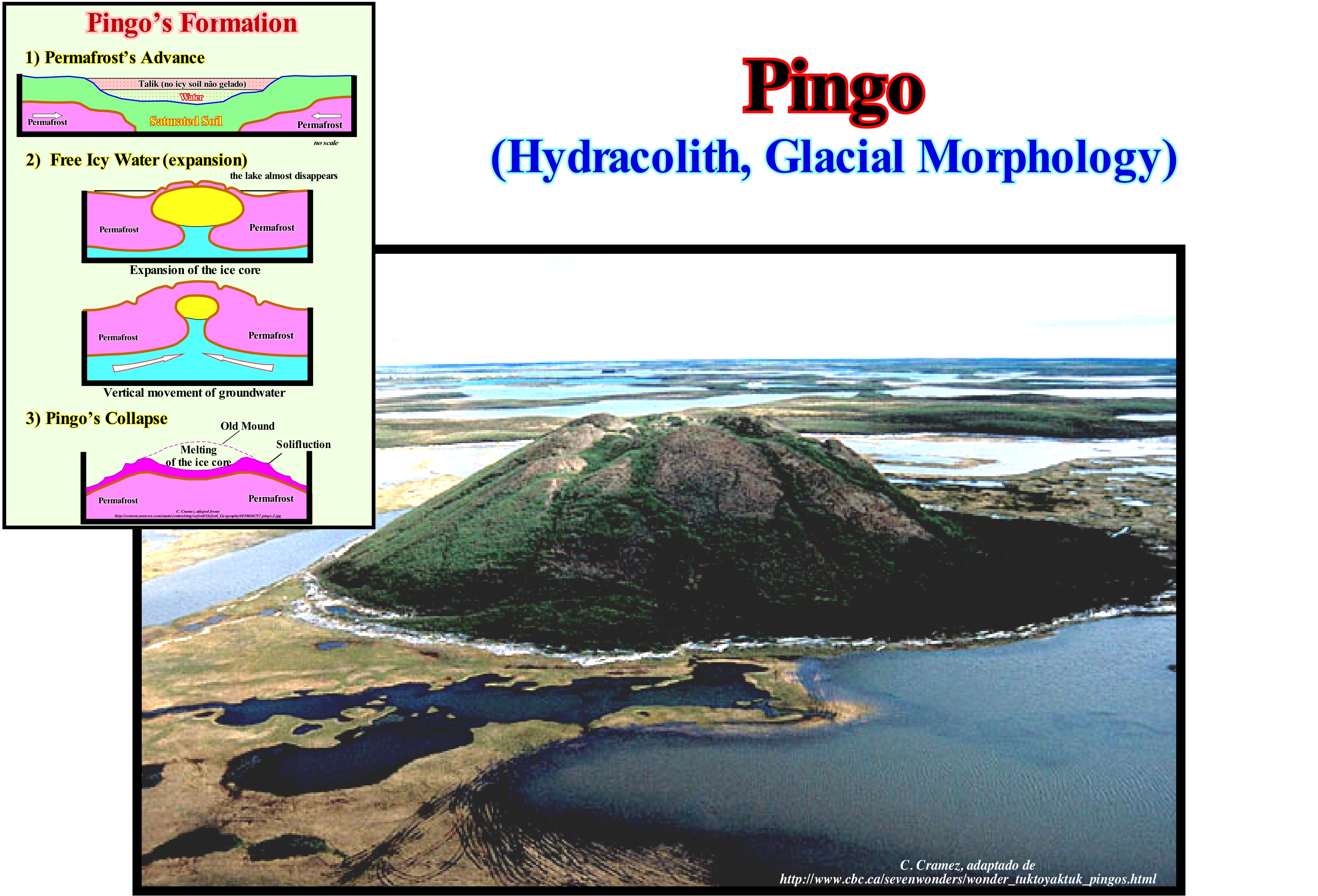
Pingos (or hydrolacoliths) are isolated conical mounds whose core is ice. They form in permafrost regions when lakes dry up. When freezing, the water on the lake floor swells, pushing up a pile of land. The drops can be classified into two categories: (i) Hydrostatic pingos, when they form a closed system, in which the water that forms the drop comes from the permafrost and (ii) Hydraulic pingos, when the system is opened, that is when the water that forms the pingo has an external origin (rain, runoff, deep permafrost, etc.). These two types of pingos can be distinguished by the presence (hydrostatic) or the absence (hydraulic) of lacustrine deposits. The pingos form only in environments that bring into play a permafrost and a mobile terrain. When vestiges of a pingo are found, it can be inferred that the site was occupied by permafrost. Hydrostatic pingos form, generally, in an isolated manner (which is not to say there are no others in the vicinity), whereas hydraulic pingos tend to form in groups, as suggested in the sketch shown in this figure, pingos grow only a few centimeters per year and larger ones can take hundreds of years to form. This process is based on the expansion of the water when it freezes and the cycles of freezing and thawing of the permafrost. The hydrostatic pingos form under the lakes in soils subject to the permafrost. The presence of a lake isolates the soil from below, protecting it from the cold so that it does not become permafrost. During the thaw, it happens that some of these lakes empty quickly. The non iced soil soaked with water is thus in contact with the cold and freezes. The water under pressure contained in the soil is regrouped in the form of an ice sheet according to the principle of an artesian well, that is, it expands and generates the permafrost that recovers it. For years, drips grow by successive additions of water from the soil. Thus, a hill is born whose nucleus is made of ice, covered with a layer of permafrost, that can include in the part superior a small lake formed by the melted water of the ice of the pingos. The largest hole in the world, it is located in Canada, near Tuktoyaktuk, on the west coast of the Canadian Arctic, measuring about 50 m in height and 300 m in circumference.
Pinnacle (Stack)...........................................................................................................................................................Pillier marin, Pinacle (Rocheux)
(Leixão (rocha) / Farallón / Säulen, Pfeiler / 巅峰 / Скалистые прибрежные скалы / Pinnacolo /
Needle shaped rock resulting from the collapse of a natural arch.
See: « Promontory »
&
« Natural Arch »
&
« Erosion »
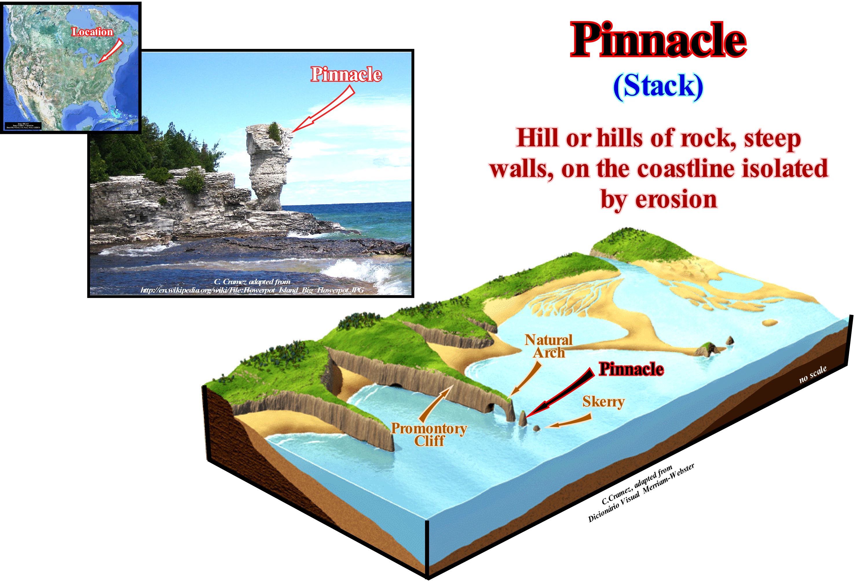
As illustrated in this figure, a pinnacle is a geological morphology formed by a rocky vertical column, often steep or a rocky column in the sea near the shoreline. The pinnacles are formed when part of a promontory is eroded, leaving a small island. Pinnacles also form when a natural arches falls due to subaerial processes and gravity. A pinnacle may collapse or be eroded leaving a skerry. Indeed, it is, often, possible, as in the sketch of this figure, to deduce the evolution of a cliff or promontory, to a natural arch, which later becomes a pinnacle, to, eventually, become a rock that disappears, eventually, by immersion. Pinnacles form very, frequently, in cliffs of chalk, due to the resistance of this rock to erosion. Cliffs consisting of weak rocks, such as shales that tend to fall and to be corroded very rapidly, to form pinnacles, whereas cliffs or promontories consisting of harder rocks, such as granites, are eroded in ways different. Pinnacles are almost always used by sea-birds for nesting times and also, unfortunately, by climbers for climbing. In the Mediterranean and, particularly, in Italy, the pinnacles are called faraglioni, which are defined as needles or stone pinnacles, typical of the Mediterranean, highlighted by coastal erosion and which may or may not form an island. These pinnacles are present along the coasts and cliffs of the Mediterranean and have formed a natural coastal arch, which sometimes collapsed. These pinnacles are, often, identified in local legends as petrified human or mythological figures. In Italy, the most famous pinnacles are in Capri and in the Cyclops islands in front of Aci Trezza, but also in the islands of Giglio, Aeolian, Pantelleria, Scopello, etc. On the southwest coast of Sardinia, in front of the beach of Masua in the region of Iglesias, there are five pinnacles fused in a single central block called Sugar Loaf. In the south Portuguese coast there are several pinnacles. In the region of Leixões, near the city of Oporto, the abundance of skerries suggests that in the past, the pinnacles were very probable.
Planar Jet..............................................................................................................................................................................................................................................Jet planaire
Jacto plano / Chorro plano / Planar-Jet / 平面射流 / Плоская струя / Getto piatto /
In geology, a jet or planar flow is a flow of water characteristic of a hyperpycnal stream, which, when it enters another water-body (by definition denser) propagates in a planar way along the bottom of the receiving water-body.
See: »Axial Jet »
&
« Delta »
&
« Turbidite »
From the precipitation that reaches the ground, one of the terrestrial surface, a part is retained either in depressions or retained as a film around solid particles. From the surplus of the retained water, one part infiltrates the land (which may later outcrop as a source for new surface runoff) and a part flows freely at the surface of the land until it reaches a river. The river flow rate ( flow volume per unit of time, expressed in cubic meters per second, m³ s-1 or in litres per second Ls-1) is the main quantity that characterizes a flow that can be fed either by an excess of precipitation or by groundwater. A river can transport sedimentary particles in several different ways: (i) Solution (water, by percolating rocks, dissolves various substances) ; (ii) Mechanical and colloidal suspension (a stream of water has the ability to hold solid particles in suspension due to its velocity and turbulence) and (iii) Dragging and jumping (the movement of the water exerts a horizontal pressure on the bed, which increases with the speed and viscosity of the water). If the bed is made of unconsolidated material, it will be set in motion by the force of the water. Larger sedimentary particles are pushed and, often, fall, while smaller ones roll and jump in a disordered motion. It is the set of all the material transported that determines the density of the current when it enters a body of receiving water (sea, lake or other river). When a river enters a body of water, the current behaviour and the way the sedimentary particles settle down depends on the relative predominance between: (i) The inertia of the river current and the way the river mixes with the water in the receiving basin ; (ii) The friction of the river water at the mouth and (iii) The river water buoyancy at the mouth. The factors that determine the role played by each element are: (a) The density contrast between the river water and the receiving water-body ; (b) The concentration and granulometry of the transported sedimentary particles, as well as the ratio of the material carried in suspension to the total load ; (c) The water-depth of the receiving water-body ; (d) The discharge of river water and (e) The flow velocity of the river. The most important factor is, probably, the difference in density between the river water and the receiving water-body. Three situations are possible: (i) If the water density of the river is greater than the density of the water in the receiving basin, the river flow is hyperpicnal (the water of the river plunges to the bottom of the receiving basin, as a turbidity stream, with a planar jet flow in the central part and a mixing zone on the outside, as shown in the map and AB profile) ; (ii) If the water density of the river is less than the reception water density, the flow is hypopycnal (sedimentary particles spread to the surface of the receiving basin and deposited, gradually, on the bottom as a hemipelagite) and (iii) If the water density of the river is equal to that of the receiving water, the flow is homogeneous (the sedimentary particles deposit forming a mouth-bar and, often, a Gilbert-type delta (the transported sedimentary particles deposited, in the sea or in a lake, when the shoreline is near the bayline), in particular, when the river current carries an important sandy load. In the E. Mutti’s model of turbidite deposition (flooding of rivers) and of Vail's model (erosional surfaces, i.e., unconformities)) the turbidity currents are hyperpicnal. Taking into account the flow of water, the rivers can be: (i) Intermittent or temporary, when they run just during a period of the year, in general, for climatic reasons ; (ii) Perennials, when they run the whole year ; (iii) Ephemeral, when they run just on occasions of heavy rains. Taking into account the shape of relief, two types of rivers are often considered: (A) Plateau Rivers flowing in relief areas accentuated by a strong flow due to the difference in altitude between the source and the mouth ; (B) Plain Rivers, which have a, more or less, regular course, with a little rapid flow characterized by the presence of meanders and point bars. Taking into account the way rivers flow, the hydrographic basins (drainage basins) can be classified into: 1) Exorheic, when the waters drain directly into the sea ; 2) Endorheic, when the waters end in a lake or closed sea ; 3) Arheic, when the waters flow into water tables ; 4) Cryptorheic, when the rivers seep into the soil without feeding groundwater or evaporating.
(*) Archimedes' principle states that "an object totally or partially immersed in a liquid undergoes the action of a vertical force, from the bottom upwards, of intensity equal to the weight of the fluid displaced by that object". I = ρ.g.V where I is the impulse, ρ is the density of the fluid, g is the acceleration of gravity and V is the volume of fluid displaced. Archimedes concluded that a floating body displaces an amount of fluid equal to its own weight. Note that this "fluid" is not necessarily water and may even be a gas. (http://ciencia-em-si.webnode.pt/products/principio-de-flutuabilidade/).
Planck's Constant...................................................................................................................................................................Constante de Plank
Constante de Planck / Constante de Planck / Planck-Konstante / 普朗克常数 / Постоянная Планка / Costante di Planck /
Physical constant (6.626068 × 10⁻³⁴ m2 kg/s) used to describe quanta sizes in quantum mechanics. It is the constant of proportionality between the energy of a photon and the frequency of that same photon.
See: « Early Universe »
&
« Cosmologic Time »
&
« Cryptozoic »
The amount of energy* a photon has, sometimes, causes it to behave more like a wave, and at other times, it behaves like a particle. This is what scientists call the "wave-particle duality" of light. It is important to understand that we are not talking about a difference in which light is, but just in the way it behaves. Low-energy photons (like radio photons) behave more like waves, while higher-energy photons (such as x-rays) behave, more, like particles. This is an important difference that geoscientists know when they design detectors and telescopes in order to "see" the electromagnetic radiation of very low or very high energy. They choose the description of the light they need for their study. The truth is that the electromagnetic spectrum, i.e., the full range of frequencies, from radio waves to gamma rays, which characterizes light, can be expressed in terms of energy, wave-length, or frequency. Each way of thinking about the electromagnetic spectrum is related to the others in a precise mathematical way. The relationships are: the wave-length, that is, the distance between adjacent peaks in a series of periodic waves, is equal to the speed of light (299792458 m/s) divided by frequency, which is the property of a wave that describes when patterns of waves or cycles pass at a given site, for a period of time or more formally: lambda = c/nu, and the energy is equal to the Planck constant (fundamental constant that is equal to the relation between the energy of an energy quanta and its frequency) multiplied by the frequency or E = h x Nu. Lambda (λ) and Nu are just the letters of the Greek alphabet that scientists like to use instead of l or f, but that seem to help them keep things online. Both the velocity of light and the Planck constant are constant. They never change: (i) The velocity of light is equal to 299792458 m/s and (ii) Planck's constant is equal to 6.626 x 10⁻²⁷ second erg.
(*) In Physics energy is the ability to do a work and work is accomplished every time object is displaced by a force. More the object is displaced the greater is work, greater is the force more the work is important. There are two types of energy, the kinetic energy, that is, the ability to do work through the movement and the potential energy, that is to say, the ability to do work through the position. Although we often meet terms such as electrical energy, chemical energy, nuclear energy such things do not really exist. They are only practical abbreviations for specific combinations of the kinetic energy and potential energy.. The exception to this universality of the kynetic energy and potential energy is the energy of electromagnetic radiation, such as the energy of light, such as the one transported from the Sun to Earth and which heats us or aliments photosynthesis.
Planetary (Worldwide, global)..............................................................................................................................................Planétaire (En géologie)
Planetário / Planetario (en geología) / Allumfassend / 全球 / Всемирный (распространяющийся на всю землю) / Globali, Mondiale /
When it contains or applies to the entire surface of the Earth. Synonym with Global (in Geology).
See: « Global (geological event) »
&
« Geological Change »
&
« Eustasy »
Theoretically, in sequential stratigraphy, unconformities bound stratigraphic cycles induced by the 3rd order eustatic cycles whose time-duration varies between 0.5 and 3-5 My. However, experience shows that neither all unconformities, that is, nor all the relative sea level falls, which bring sea level lower than the basin edge, are global. This means that in different sedimentary basins, located in different parts of the world, some unconformities are not of same age (the age of turbiditic deposits associated with relative sea level falls), which means that they do not correspond to global geological events. A typical example of local unconformities, which do not normally correspond to stratigraphic cycle boundaries, are the unconformities created by meander formation in the alluvial plain. This is particularly true with respect to the surface delimited by the onlaps of the clay plugs (abandoned meander channels filled with fine clastic materials, in particular clays and organic matter, which may form barrier impermeable, in the form of crescent, within of the meandering sandy belts). On the contrary, as illustrated on this tentative interpretation of a Canvas auto-trace of a Cameroon offshore seismic line, the SB. 30 Ma unconformity (erosional surface) corresponds to a global fall of the absolute (eustatic) sea level that can be found in all sedimentary basins, particularly in all the continental margins, whether they are divergent or convergent. We recall that absolute or eustatic sea level (supposed to be global) unlike the relative sea level (local) sea level is referenced to a fixed terrestrial point which is, generally, the Earth's centre. This absolute sea level fall seems to have been induced by the Antarctic ice cap, which has, significantly, decreased the sea-water volume, which is not the case for the formation of an ice sea, since the density of the ice is smaller than the density of water. On this subject never forget that unlike most substances the water increases in volume when it freezes. Thus, the melting of a glacial ice cap (ice on solid earth) increases the absolute (eustatic) sea level. Unlike the melting of a sea of ice, such as the Arctic sea ice (the ice cover of Arctic Ocean and its vicinity, which can reach 3-4 meters thick with furrows up to 20 meters thick) induce a absolute sea level fall (ice is lesser dense than water).
Plankton............................................................................................................................................................................................................................................Plancton
Plâncton / Plancton / Plankton / 浮游生物 / Планктон / Plancton /
A set of microscopic plants and animals that live in suspension in water and it ia at the bottom of many food chains. From the Greek "plagktón", that is, wandering or at favour of the sea-waves.
See: « Benthos »
&
« Pelagic (organism) »
&
« Wave Action Level »
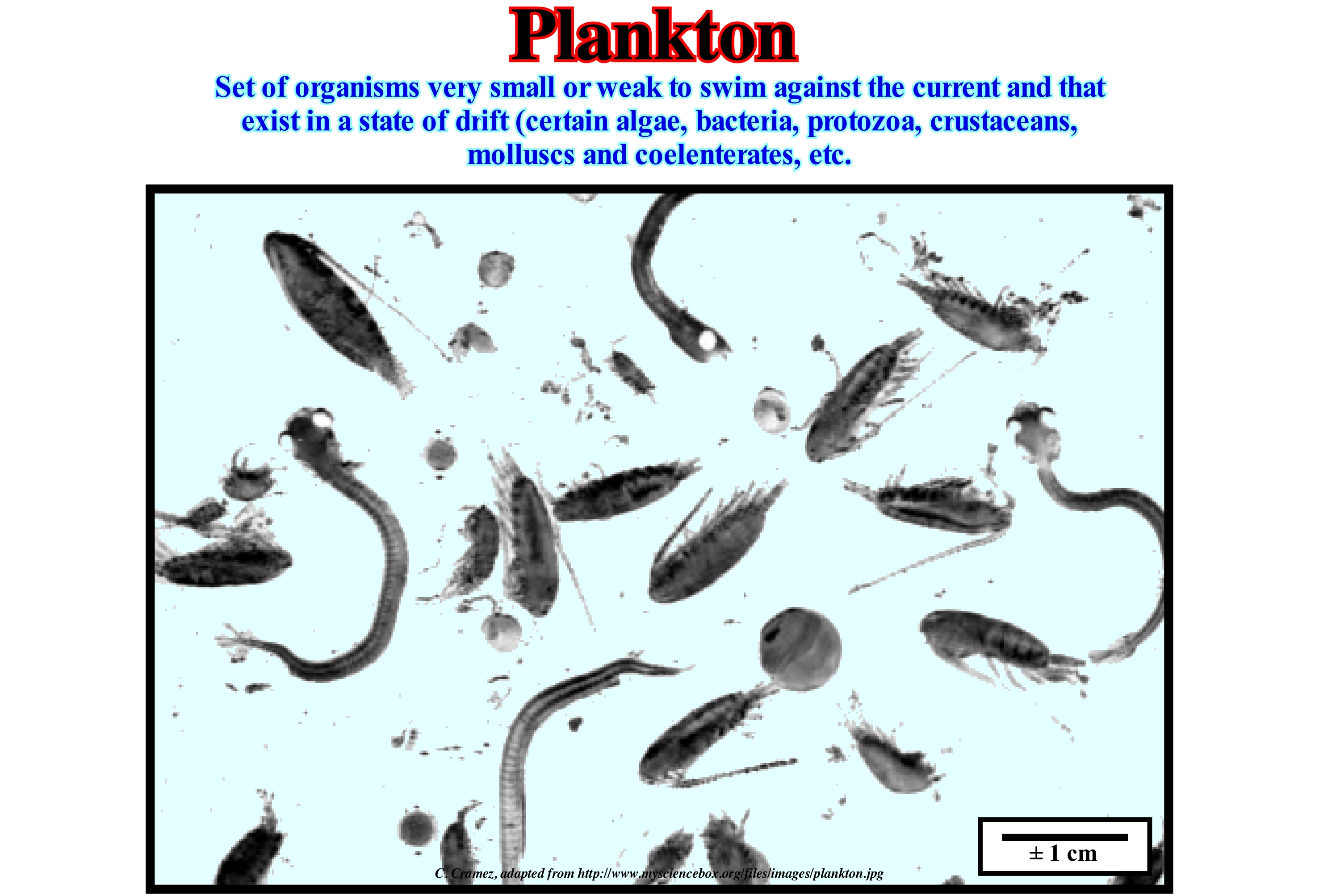
Plankton is made of animals and plants, which either, passively, float in the water or swim very little, and which are transported from one place to another by the sea currents. Plankton, which dominates the photic zone of the ocean, consists of organisms ranging in size from small microbes (femtoplankton), which are invisible to the naked eye, to jellyfish, which may be several meters long (megaplankton). With the exception of bacteria, planktonic organisms are the most abundant form of Earth's life and play a key role in the marine food chain. Without plankton, there would be few living organisms on Earth and, certainly, there would be no reefs. The planktonic organisms are the food of a whole series of animals from the barnacles and ascidian or sea squirt, (mollusc cephalus, which resembles a seaweed) to large fish and whales. The largest whale shark in the world, which can reach 14 meters in length and weigh about 15 tonnes, feeds on plankton, as do most whales (mammals of the cetacean family). Phytoplankton is plant plankton. The most common is diatoms (unicellular algae that join together to form long filaments) and dinoflagellates (small organisms that have two tails or flagella). The brown algae, that is, the Phaeophyta and the green or the Cyanobacteria are other types of phytoplankton. Zooplankton is animal plankton. There are two types of zooplankton: (i) Permanent (holoplankton), which is always a zooplankton and (ii) Temporary (meroplankton), which is made of fish larvae, crustaceans, and other marine animals, which if they survive will grow and part of the nekton (swimming organisms). As zooplankton we can mention: (a) Foraminifera (thorny or not with a carapace of calcite pierced by numerous pores from which emerge rhizopods) ; (b) Radiolaria (silica spicule skeleton and cell compartmentalized in 2 regions); (c) Zooflagelates, (such as dinoflagellates have a long tail); (d) Jellyfish ; (e) Siphozoans (hydrozoans where polyps and jellyfish with high polymorphism coexist), etc.
Plate Tectonics..................................................................................................................................................................Tectonique des Plaques
Tectónica das Placas / Tectónica das Placas/ Plattentektonik / 板块构造 / Тектоника плит / Tettonica delle placche /
Geological theory that explains how the lithosphere is structured and explains: (i) The lithospheric plates, which form the surface of the Earth ; (ii) The slips between them, their movement on the Earth's mantle, their directions and interactions ; (iii) The formation of mountain ranges (orogenes) ; (iv) Why do earthquakes and volcanoes focus, primarily, on certain regions of the globe, such as along the Pacific Ring of Fire ; (v) Why are the large ocean trenches near islands and continents rather than the center of the oceans ; (vi) The megasutures, i.e., the moving regions of the Earth (faulted and folded mountain ranges), which testify to the complexity of the accretion and deformation phases undergone by geological bodies in regions where compressive tectonic regimes are predominant, etc., etc.
See: « Plate Tectonics Theory »
Plate Tectonics Theory............................................................................Théorie de la tectonique des plaques
Teoria da Tectónica das Placas / Teoría de la tectónica de placas / Theorie der Plattentektonik / 板块构造理论 / Теория тектоники платформ / Teoria della tettonica a zolle /
Theory that explains the movements observed in the terrestrial lithosphere, on a large scale. This theory, which encompasses and replaced (in the 1960s) the old theory of continental drift, proposed at the beginning of the 20th century by Wegener, introduced and developed the concept of sea floor spreading (oceanic expansion or formation of new oceanic crust).
Ver: « Continental Collision »
&
« B-Type Subduction (Benioff) »
&
« Supercontinent »
The theory of plate tectonics implies: (i) The formation of rift-type basins by lengthening the lithosphere of a supercontinent ; (ii) The supercontinent break-up by lengthening/thinning of the lithosphere and injection of sublitospheric mantle material* into the continental crust ; (iii) The formation of new oceans (expansion or oceanic spread, which may initially be subaerial, that is, caused by spills of subaerial lavas), due to the creation of new oceanic crustacean along the mid-ocean ridges, the continents individualized by the rupture of the supercontinents ; (iv) The closing of the oceans, due to the plunging and assimilation, by the asthenosphere, of the old oceanic crust along the subduction zone ; (v) Collision of the continents with each other along the subduction zones, either B type (Benioff, when the descending lithospheric plate is oceanic) or A type (Ampferer, when the descending plate is continental) ; (vi) The oceanic spreading and, particularly, the formation of oceanic ridges, reduces the volume of the oceanic basins, which for a constant volume of water, in all forms, since the Earth formation around 4.5 Ga (axiom that the largest part of the geoscientists adopts), induces an absolute (eustatic) sea level rise ; (vii) The subduction of the old crust and ocean ridges increases the volume of the oceanic basins, which for a constant volume of water, in all its form,s induces an absolute sea level fall. All paleogeographic reconstitutions proposed, for example, for the Paleozoic Era are based on the plate tectonics theory and admit the formation of two great oceans (Iapetus and Rheic) in the Early Paleozoic, which were closed during the Permian / Triassic period. According to Perroud (1990) it can be said that: (1) In the Ordovician, the Iapetus Sea that existed between Europe and North America, between 570 Ma and 420 Ma ; (2) About 600 Ma, Europe and America of the North, which were more or less together, began to separate as the magma of the lower crust rose to the surface to fill the space created by the separation of the continents ; (3) About 460 Ma, North America and Europe collided forming the Appalachians at the same time as the Iapetus Sea closed ; (4) The Rheic Sea formed in the Late Cambrian/Early Ordovician by extension and rupture of lands or microcontinents of the north margin of the Gondwana small supercontinent ; (5) The collapse of the Pacific Ocean as a result of the continent/continent collisions that formed the Pangea supercontinent, the expansion of the Rheic Sea was made as the Sea of Iapetus closed due to the collision between the Gondwana small supercontinents and Laurasia ; (6) From the Ordovician, the Iapetus Sea began to close as the Laurentia and Baltica approached ; (7) In the Devonian, the Iapetus Sea disappeared with the formation of the continent of the old red sandstones (Caledonian or Taconic orogeny) ; (8) The Rheic Sea disappeared at the end of the Paleozoic with the advent of the Hercynian orogeny. In the same way, as illustrated in this figure, at the beginning of the Mesozoic/Cenozoic, almost all geoscientists admit that the supercontinent Pangea (formed at the end of the Paleozoic), which was surrounded by a large and single ocean, Panthalassa ***, fractured on several continents, which separate from each other as a new oceanic crust formed on the mid-ocean ridges. Currently, the continents seem to have reached the maximum of dispersion, as in the Portugal offshore, where there appears to be already evidence (B subduction zone) that the continental agglutination mechanism has already begun.
(*) Plastic layer of rocks that are in the solid state but very close to its melting point state, which divides into the asthenosphere (part of the mantle that behaves mantle fluidly and where the seismic waves change speed) and mesosphere, where the materials become denser without changing their chemical composition. The sub-lithospheric mantle corresponds to the upper part of the earth's mantle, that is above the isothermal 1350° C, or in other words it is the part of the terrestrial mantle that is part of the asthenosphere.
(**) Attention to the term collision here used, since in the plate tectonics and unlike the collision of a car against a wall, the kinetic energy plays no important role, that is to say, that in the plate tectonics there is no transformation of kinetic energy in strain energy.
(***) The gulf to the east of this supercontinent is the Tethys Sea, between the small supercontinents Gondwana (NE) and Laurasia (SE), which replaced the Paleotethys ocean (formerly the Sea of Tethys of Suess, i.e., the Paleozoic Ocean, between Gondwana, Central Europe, Iberia, China and Central Asia). The Tethys Sea began to form in the south of Paleotethys since the Cimmerian plate was individualized (Permian / Triassic). The expansion of the Tethys Sea forced the Cimmerian plate to collide with Laurasia, to finally, the Tethys Sea replace, completely, the Paleotethys
Plateau.......................................................................................................................................................................................................................................................Plateau
Planalto / Plateau / Hochebene / 高原 / Плато / Altopiano /
Flat area whose height stands out in relation to the plan of the neighboring regions.
In geology, a plateau is a flat, high, large terrain (not to be confused with a mesa) or a great plain on hills. When a plateau is very eroded like, which is illustrated in this photograph (Colorado Plateau, USA), it is sometimes called dissected plateau. When a plateau is created by volcanic activity it is spoken of a volcanic plateau. Some geoscientists consider that a plateau must be at least 500 meters higher than the terrain around it and that one of its sides must be very steep. The surface of a plateau is very variable. There are plateaus the size of a city, but there are also others that have several times the surface of country. The highest and highest plateau in the world is the plateau of Tibet, which is perhaps best known by the name "Ceiling of the World". The Tibet plateau, which resulted from the collision between the Indo-Australian and Eurasian lithospheric plates, is still rising today. Some plateaus result from a rapid geological survey (in geological terms), others are associated with slow vertical movements of large stable geological units. Still others, like the roof of the world, that are located, generally, between the mountains, result from the collision of lithospheric plates. About 45% of the Earth's total surface is formed of plateaus. In Australia, two-thirds of the land surface is occupied by the Western Plateau, which has, probably, existed for more than 500 Ma (Paleozoic). About 25% of China's surface is made up of plateaus. The plateaus, like all high lands, are y carved, continually, by erosion. When the plateaus have rivers they are cut by canyons, which dig them, as they try to reach the base level of the lakes or the ocean to which they flow. The formation of such canyons with valley meanders (not to be confused with meanders of alluvial plain), as illustrated in this photograph, can take tens of millions of years. In fact, there are two main types of meanders: (i) Valley Meanders or Incised meanders are those in which the valley of the meander river as the river, on the same scale, which means that the meanders are more or less permanent ; (ii) Alluvial Plain Meanders of, which certain French geoscientists call, erroneously, free meanders or wandering meanders, are those in which the sinuosities of the river are independent of the layout of the valley and have very different scales, i.e., the valley is very larger than the river and that the meanders, which are not permanent. The tendency for lowland rivers to form meanders is a form of energy dissipation in periods when flow rates (*) (flow rate = precipitation - infiltration - evapotranspiration) are higher. As an example of the former we can mention the meanders of the Douro or Mondego rivers (between Penacova and Coimbra, where the river runs through a narrow valley). Examples of the others are the meanders of the Mississippi River (the United States) or Amazonas (Brazil). The term plateau is used, also, by many geoscientists to designate certain underwater topographies, whether associated with continental crust, such as the Seychelles plateau, or volcanic spills such as the Ontong Java Plateau in SE Asia. With respect to the surrounding terrain, the "tepuis" of Venezuela, Brazil and Guyana are the highest plateaus, with vertical walls of more than one kilometre of altitude. The term "tepui", which in the native language of Pemon (indigenous peoples who inhabit the Great Savannah) means "house of the gods", designates the horizontal top or table of the highlands of Guyana (South America), especially, in Venezuela and eastern Guyana. The "Tepuis" are more like isolated entities than connected, which favours the development of endemic species of plants and animals. Among the most well-known "tepuis" we can mention are Neblina, Autana, Auyantepui and Monte Roraima, which are, normally, composed of blocks of pre-Cambrian quartzite sandstone that rise abruptly from the jungle, giving rise to spectacular natural landscapes. The "tepui" of Auyantepui is the source of the "Falls of the Angel" (State of Bolivia, Venezuela), which are the The highest water-falls in the world, with a height of 979 meters and a dive of 807 meters. The 979 meters high include about 400 meters of inclined and fast water-falls under the main jump and a diving or about 30 meters downstream from the rapids (https://en.wikipedia.org/wiki/ Angel_Falls).
(*) When the flow increases, there is an increase in water level and erosion of the river bottom. When the flow decreases, the water level is low and there is sediment deposition.
Platform Margin Reef (Carbonate facies belt).........Récif du bord de la plate-forme(Ceinture carbonatée)
Recife de bordo de plataforma / Arrecife de borde de Plataforma (cintura carbonatada) / Platform Marge Riff / 台缘礁 / Риф с края платформы / Piattaforma margine di barriera corallina /
Organic construction bordering certain carbonated platforms. A reef edge is composed almost exclusively of benthos and remains of skeletons. It is supported by a macroscopic skeletal structure where corals and calcareous algae grow on top of each other forming a three-dimensional structure that can be modified by other organisms and inorganic processes.
See: « Bioherm »
&
« Transgressive Interval »
&
« Deposition (carbonates) »
In this sketch, the organic build-up or platform margin reef underscore the outer margin of the fringed (rimmed) platforms (platform attached to the mainland) and also of the isolated platforms (not connected to the mainland), in particular the windward margin (side of platform where blowing the wind or receiving the wind). Such reefs may develop as: (i) Stable organic muddy mounds of the upper slope; (ii) Barrier reefs (stacking of limestone accumulated on the seabed) and sand formed from the remains of limestone skeletons ; (iii) Wave-resistant barrier reefs that border the carbonated platform. The sediments of these reefs are mainly carbonate grains, almost pure, of different sizes. The most characteristic are masses or pieces of bioconstructed or framestone limestone, internal cavities filled with cement or sediments, multiple generations of organic construction, incrustations, perforations, etc. The biota is exclusively benthic. Colonies of builders, encrusters, and drillers are frequent as are a large amount of debris and sand from carbonate skeletons. The most frequent sedimentary bodies in the margin reefs of a carbonated platform are: (a) Mounds of the base of the slope ; (b) Mounded reefs ; (c) Mounds of bioconstructed limestone ; (d) Fringing and barrier reefs and (e) Spurs and furrows. On the other hand, the most frequent microfacies are: (1) Bioconstructed limestone; (2) Grainstone coated, aneliditic, bioclastic ; (3) Lumachel ; (4) Floatstone (millimetre grains in a fine limestone matrix) ; (5) Rudites ; (6) "Bafflestone" (autochthonous carbonate whose original components are organically bound during the deposit), etc. Most geoscientists consider five types of carbonated platforms: (i) Rimmed Platforms ; (ii) Carbonated Ramps ; (iii) Epeirial (or epíric) platforms ; (iv) Isolated Platforms ; (v) Dead or Drowned Platform. Rimmed platforms are characterized by the presence of reefs or reefal shoals in the edge of the platform. These platforms are developed in calm waters and their width can vary between 10 and 100 km. Carbonated Ramps, as illustrated in this figure, and in which the shoreline carbonated sands pass, at the base of the ramp, to the clay sands and water deep muds. Carbonate ramps, where reefs are little present, can reach a width of about 100 km. Epeirial (or epíric) platforms are characterized by the presence of tidal surfaces and protected lagoons. The width of these platforms can reach 10,000 km. isolated Platforms are characterized by the fact that the facies are controlled by the orientation of the dominant winds. As in the rimmed platform, reefs and sandy bodies are located in the windward margin (that receives the wind, as opposed to the leeward), whereas in the leeward margin (margin that lets the wind pass) the sediments are more muddy. An isolated platform can reach 100 km wide. Dead or Drowned Platform are under the photic zone. The most well known carbonate platform geometry is associated with tropical manufacturing processes, where carbonate platforms can be subdivided into three main sedimentary environments: A) Reef, which is the part of the carbonate platform created in situ by sessile organisms ; B) Internal lagoon (part of the platform behind the reef, which is characterized by shallow and calm waters with sediments composed of fragments of reefs and hard parts of organisms or terrigeneous sediments when the reef is epicontinental) and C) Slope, which connects the reef to the basin and acts as a sink for the excess carbonate sediment, although most of the sediment produced in the lagoon and the reef is transported by various processes and accumulated on the slope. The platforms connected to the continent are divided into two large families: (A) Ramp Type Platforms and Platform with rupture. In ramp platforms two sub-types can be considered: (A.1) Monoclinal Ramp Type Platform and (A.2) Ramp Type Platforms with Small Distal Rupture. In platforms with rupture there are also two sub-types: (B.1) Non-rimmed platforms and (B.2) Rimmed Platforms. It is in the sub-type of platform with rupture that the designation of abrupt carbonated platform is more frequent. On a carbonated ramp, the original slope is less than 1° and the basin edge is difficult to individualize since there is, practically, no slope break along the depositional surface. Certain geoscientists divide the carbonate ramps into homoclinal (steep slopes) and abrupt slopes (rupture in the distal part). Differentiation is problematic unless there are base slope deposits. Other geoscientists use the depth of wave action (in calm and agitated sea) to subdivide the ramps. The lithology of the carbonated ramps reflects the energy variations that are a function of the variations of the water-depth.

