
Chlorophyll....................................................................................................................................................................................................................Chlorophylle
Clorofila / Clorofila / Chlorophyll / 叶绿素 / Хлорофилл / Clorofilla /
Group of photosynthetic pigments present in the chloroplasts of plants (including algae, cyanophytes and several protists previously considered "algae" or "plants", such as red or brown algae).
See: « Algae »
&
« Photosynthesis »
&
« Food Chain »
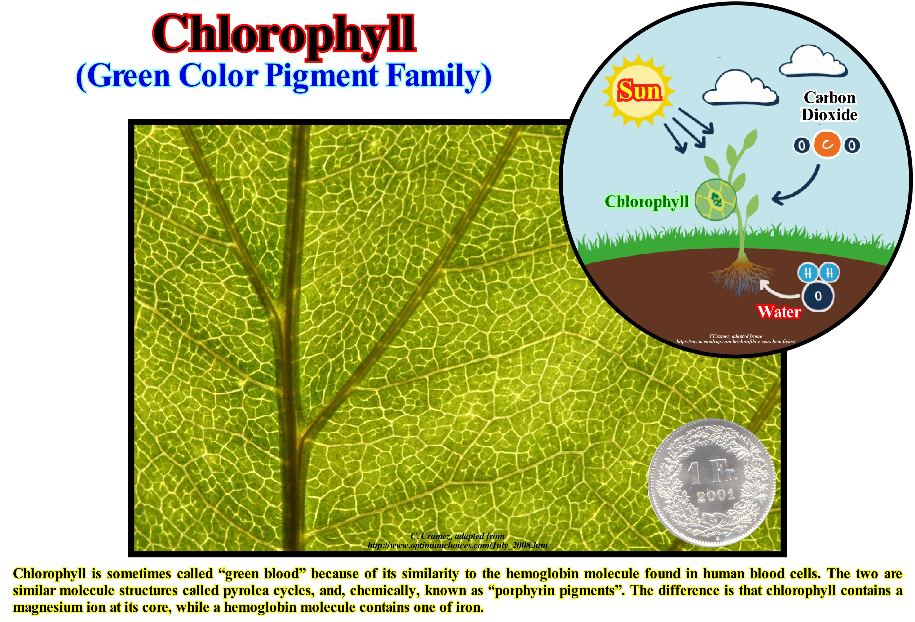
The intense green colour of chlorophyll is due to the strong absorption* of the blue and red regions of the electromagnetic spectrum, and because of this absorption, the light it reflects and transmits looks green. Chlorophyll is able to channel the energy of sunlight into chemical energy through the process of photosynthesis. In this process the energy absorbed by chlorophyll transforms carbon dioxide (CO2) and water (OH2) into carbohydrates** and oxygen. The chlorophyll molecules are called photo-systems, which are integrated in the thylakoids (internal membrane systems) of the chloroplasts. Most chlorophyll molecules absorb light and transmit light energy through a phenomenon called "resonance energy transfer ***" to a pair of specific chlorophyll molecules that are in the reaction centre of the photo-systems. There are two families of photo-systems: (i) photo-system I, chloroplasts and green sulphur bacteria and (ii) photo-system II, chloroplasts and non-sulphur purple bacteria. The photo-systems I and II have distinct reaction centres, called and identified by the light length (corresponding to the maximum absorption peak) to which it is most reactive (700 and 680 nanometres, respectively) and by the final electron acceptor. The energy transferred to the chlorophyll molecules belonging to the reaction centre is used in the charge separation process, which consists in the transfer of a chlorophyll electron to an electronic transport chain. The chlorophyll of the reaction centre P680 (photo-system II), oxidized to the P680 + form, is reduced by an electron from the oxidation of water (OH2) in dioxygen (O2) and molecular hydrogen (H2). Photo-system I works in conjunction with Photo-system II. The oxidized centre (photo-system I) to P700+ is, eventually, reduced with electrons from photo-system II. Under certain conditions, the electron source for P700 + reduction may vary. The electron flux produced by chlorophyll pigments is used to transport H + ions through thylakoid membranes, causing a chemiosmotic potential used primarily in the production of ATP (adenosine triphosphate or adenosine triphosphate). (http://en.wikipedia.org/wiki/ Chlorophyll)
(*) Process in which atoms, molecules or ions enter into some other phase, usually, more massive and they are fixed.
(**) Term used to describe molecules with a structure consisting of hydrogen, oxygen and carbon. Carbohydrates are bimolecular and their main function is to provide energy to living beings so that they can perform all the physical and metabolic work necessary for their survival.
(***) Mechanism of non-radioactive energy transfer between two chromophores (atoms of a molecule responsible for their colour) without the need for re-absorption of electromagnetic radiation.
Chron...................................................................................................................................................................................................................................................................Chron
Crono / Crono / Chron / 专栏 / Крон / Chron /
Geochronological unit (time) corresponding to a chronozone (rocks). According to the ICS (International Commission on Stratigraphy), "chronozone" refers to the rocks formed during a particular time period, while "chron" refers to that time-period. A chron is an interval of time of any stratigraphic unit or geological event. during which a given set of rocks was deposited. Rocks formed during a magnetic normal or inverse polarity are chronozones (chrons that, generally, last between 10 ky and 10 My). Within a chronozone several sub-sets can be considered. The chronozone Turonian is a sub-set of the chronozone Cretaceous.
See: « Magnetostratigraphy »
&
« Chronozone »
&
« Stratigraphy »
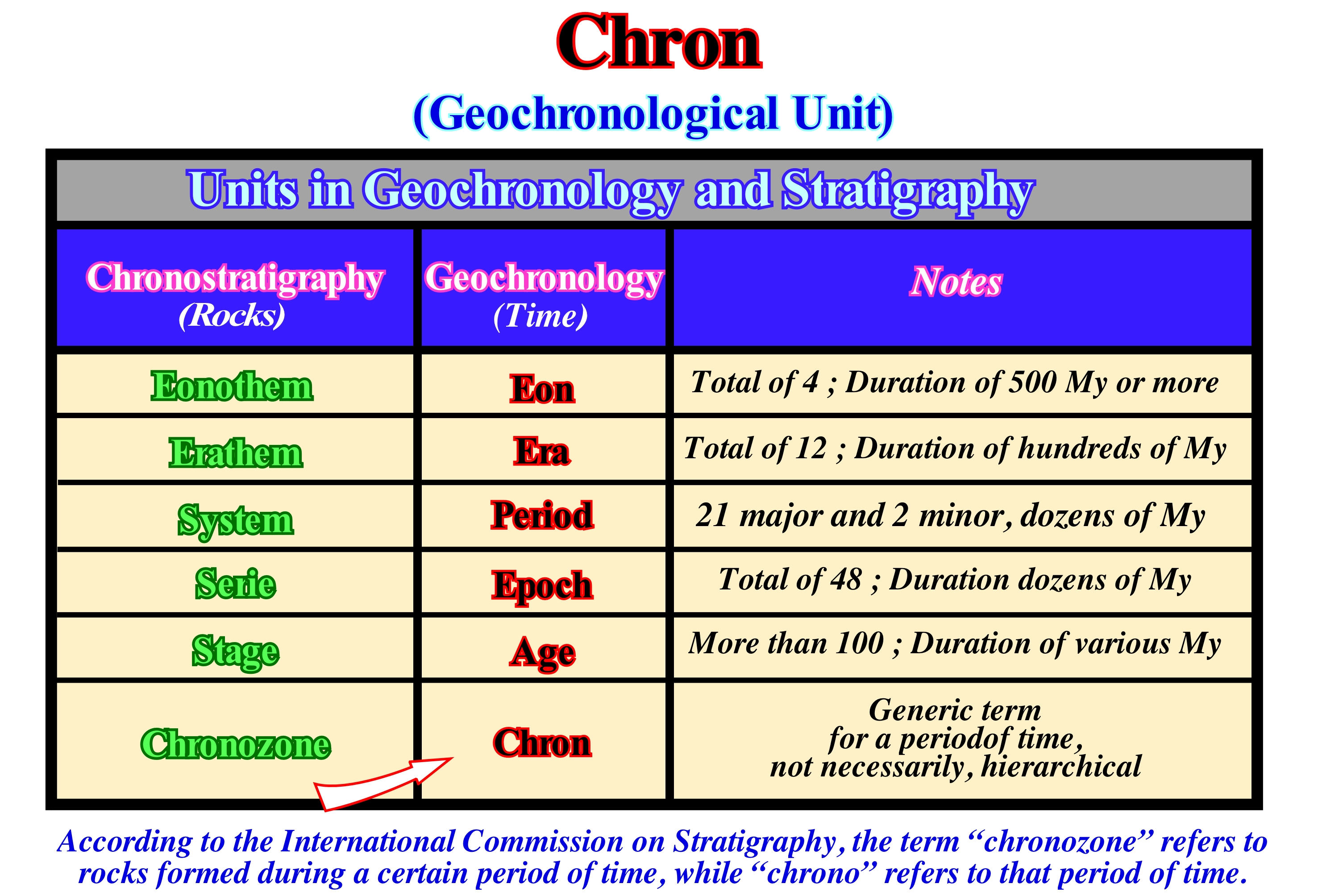
Chronostratigraphy is the branch of stratigraphy that deals with temporal relations between different rocks. Chronostratigraphic units are defined by rocks, stratified or not, that have formed over a certain geological time interval. To a certain extent, these units are conceptual. They can be considered as rocky sub-sets formed during a specific geological time. For instance, the Devonian system is a set of sedimentary, metamorphic and igneous rocks that have formed anywhere in the world during the Devonian Period (geological period). Thus, the Upper Devonian expression is used for rocks. It should be said: "The shales of the Upper Devonian" and not the shales of the Late Devonian. In the same way, it should be said: "During the Late Ordovician the CO2 content was 4.5 k ppm" and not "During the Upper Ordovician the CO2content was 4.5 k ppm". The boundaries of these rock sets are synchronous (with the same age) and the Devonian System is isochronous (same age and same duration elsewhere). When written as a proper name, such as Devonian, both parts of the name of a chronostratigraphic unit are in upper-case letter. Chronostratigraphic units, such as systems, are the basis of the Phanerozoic time scale. These units have a hierarchy: (i) Eonothem, set of strata that were deposited during an Eon, such as during the Phanerozoic ; (ii) Erathem, set of strata deposited during an Era such as during the Paleozoic ; (iii) System, set of rocks deposited during a Period such as during Devonian ; (iv) Serie, set of strata deposited during a Epoch, such as during Late Devonian ; (v) Stage, set of strata deposited during an Age as, for example, during Frasnian ; (vi) Sub-Stage (not shown in this figure), which is the set of strata deposited in a Sub-age ; (vii) Chronozone, set of layers deposited during a chron. A chron is a subdivision of an age, but is not used by the International Commission on Stratigraphy, which considers that the term "chronozone" refers to rocks formed during a certain period of time, and that "Chron" refers to such a period of time. In the geological time scale there are: a) Four (4) Eonothems with a duration superior to 500 My ; b) Twelve (12) Eras lasting a hundred of My ; c) Twenty-one (21) major Systems and two (2) small Systems with a duration of tens of My ; d) Forty-eight (48) Epochs lasting for tens of My and e) More than one hundred (>100) Ages lasting several My. The system is the fundamental chronostratigraphic unit. It is the most, often, used and referenced as chronostratigraphic unit. As illustrated in this figure, the geochronological equivalent (time) of an Enothem is an Eon, as well as Era, Period, Epoch, Age and Chron are, respectively, the time equivalents of Erathem, System, Serie, Stage and Chronozone. The purpose of chronostratigraphy is to classify the different intervals and deposition times of the rocks, depending on the geological region, and, finally, to establish a complete geological record of the Earth. Chronostratigraphy is based, mainly, on isotopic geology and geochronology (a science that aims to determine the age and chronological sequence of geological events in Earth's history and which is also responsible for the establishment of geochronological units, discrete, continuous and successive time units that provide a time scale covering the entire Earth's history) to obtain a crude dating of known and well-defined rock units containing specific sets of fossils defined by the stratigraphic system. However, in practice, it is very difficult to date, directly, by the isotopes of most fossils and sedimentary rocks, and therefore adjustments must be made to obtain a realistic dating for the beginning of the interval. The methodology used is a consequence of the principles of overlapping and inclusion. Implementations of magmatic rocks occur at specific times (time) and can be considered as an instant geological event (geological time). On the other hand, because magmatic rocks contain mineral associations that can be dated, more or less, accurately by isotopic methods*, the construction of a chronostratigraphic stratigraphic column is, mainly based on volcanic and plutonic rocks.
(*) Methods of studying geological processes based on the investigation of the content and proportions of radioactive, radiogenic and stable isotopes of chemical elements in rocks, minerals, natural waters, gases and organic matter. Absolute geochronology methods are used to determine the absolute age of rocks and minerals as a function of the proportion of radioactive isotopes and their daughter products resulting from their disintegration, such as 235U - 207Pb ; 238U - 206PPb ; 232Th - 208Pb ; 87Rb - 87Sr ; 40K - 40Ar. The rate and time of accumulation of various ocean floor sediments can be readily determined determined from the pairs 230I-232Th and (30Io - 231Ra, as well as from the absolute content of radioactive 14C and 10Be. (http://encyclopedia2.thefreedictionary.com/Isotope+Methods+ in+Geology)
Chronostratigraphic Chart......................................................................Diagramme chronostratigraphique
Diagrama cronostratigráfico / Diagrama cronostratigráfico / Chronostratigraphic Diagramm / 纪年代地层表 / Хроностратиграфическая диаграмма / Schema cronostratigrafico /
Stratigraphic diagram with the vertical scale in geological time and the horizontal in meters (equal to the scale of the equivalent geological section), in which, all the stratigraphic information (onlap, downlap, incised valley, hiatus, unconformity, systems tract, etc.) can be illustrated.
See: « Geological Section »
&
« Time Section (seismic) »
&
« Geological Time »
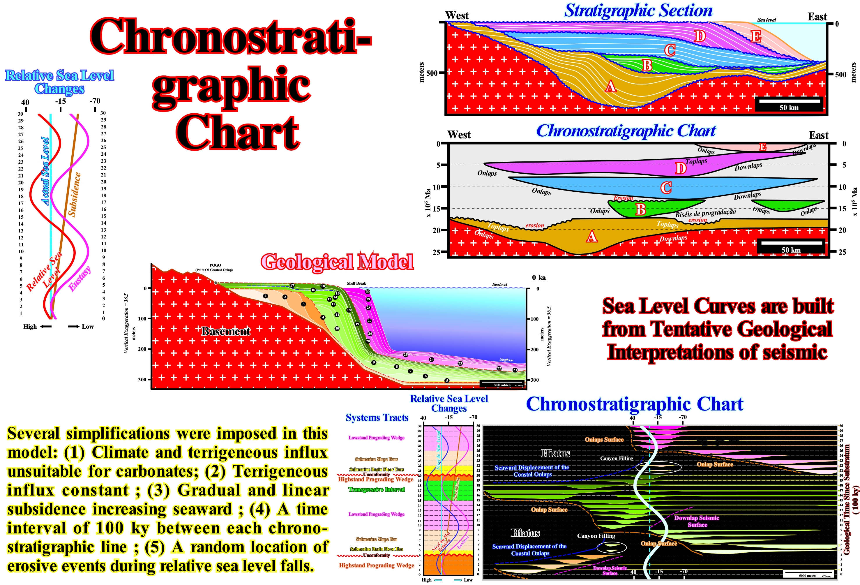
In this figure, the difference between a stratigraphic section and the corresponding chronostratigraphic diagram is illustrated. A stratigraphic section is a sequence of sedimentary layers or intervals in the order in which they were deposited showing the geometric relationships between them, which is based, generally, on tentative geological interpretations of seismic lines with metric vertical and horizontal scales. The corresponding chronostratigraphic chart has the vertical scale is in geological time (millions of years) and the horizontal in meters. The horizontal scale is equal to the horizontal scale of the stratigraphic section, in order that all the stratigraphic information can be illustrated. When a stratigraphic section is coherent and exhaustive, everything evident in the chronostratigraphic diagram is illustrated in the stratigraphic section, but is much easier to recognize. As in a chronostratigraphic chart, the continent, by convention,is always in the the left, it is easy to understand that the surfaces defined by onlaps have an up-left geometry (in time), i.e., they incline seaward. The surfaces defined by downlaps have an up-right geometry: they incline continentward. In the same way, it can be said the surfaces defined by toplaps (truncation) have, almost always, a concave geometry. In this example, the unconformities (erosional surfaces induced by significant relative sea level falls, which puts the sea level below the basin edge) separating the five sedimentary packages are evident in the stratigraphic section. However, erosion is more evident in the chronostratigraphic chart, despite the fact that the vertical and horizontal scale are very large. In the same way, the fills of the incised valleys and submarine canyons, at such scales, are, necessarily, under the seismic resolution. Thus at certain intervals, as in B and C, landward of the basin edge, there is an apparent concordance between the unconformity and the underlying and overlying sediments. On the other hand, the maximum thickness of each interval is difficult to determine in the stratigraphic section, whereas in the chronostratigraphic chart it is obvious. The reflection terminations (or associated geological interfaces) and onlap and downlap surfaces (determined from reflector terminations, lapouts) are also easier to identify in the chronostratigraphic chart. One of the rarest things, which is most evident in the stratigraphic section, is the internal configuration of the different sedimentary intervals, i.e., the geometry of the chronostratigraphic lines. It is why certain geoscientists suggest they must be drawn whenever possible. The construction of a stratigraphic chart can just be carried on if the stratigraphic section, which, as we said before, is almost always based on a tentative geological interpretation of a seismic line (depth version), is calibrated in geological time. This implies the unconformities, which limit the stratigraphic cycles are well dated. It is in this subject that sequential stratigraphy is important, since only very, rarely, an exploration well can, directly, give the most likely age of the unconformities. There is always a hiatus of deposition. It is recalled that the age of an unconformity is given by the age of the associated relative sea level fall, which can be approximated by the age of the submarine basin floor fans deposited over the unconformities, in the deep parts of the basin, i.e., over the deep-water correlative paraconformity that emphasizes the lower limit of the sequence-cyle. Submarine basin floor fans (SBFF) underline the smallest non-deposition hiatus (period of time during which no sedimentation occurred), which corresponds, more or less, to the age of relative sea level fall. However, submarine basin floor fans can just be dated from cores, when the pelagic layer (E layer in the Bouma's sequence) separating the different turbidite layers is present on the core. All the sedimentary material forming a turbiditic layer is transported of different environments and coming from rocks of different ages, which is not the case of the constituents of a pelagic layer. The geological models illustrated in the lower part of this figure outline the construction of the relative sea level changes (resulting from the combination of eustatic or absolute sea level and tectonics), as well as, the relationship between the different sub-groups of sedimentary systems tracts, which make up a sequence-cycle and the different sectors of the curve of relative sea level changes.
Chronostratigraphic Line................................................................................................Ligne chronostratigraphique
Linha cronostratigráfica / Línea cronostratigráfica / Chronostratigraphischen Linie / 年代地层线 / Хроностратиграфическая линия / Linea cronostratigrafica /
Synchronous depositional surface, which, in general, on the seismic lines corresponds, but not always, to a reflector that can be followed in continuity. Synonym of Time-Line.
See: « Horizon (geological, seismic) »
&
« Facies Line »
&
« Transverse or Strike Seismic Line »
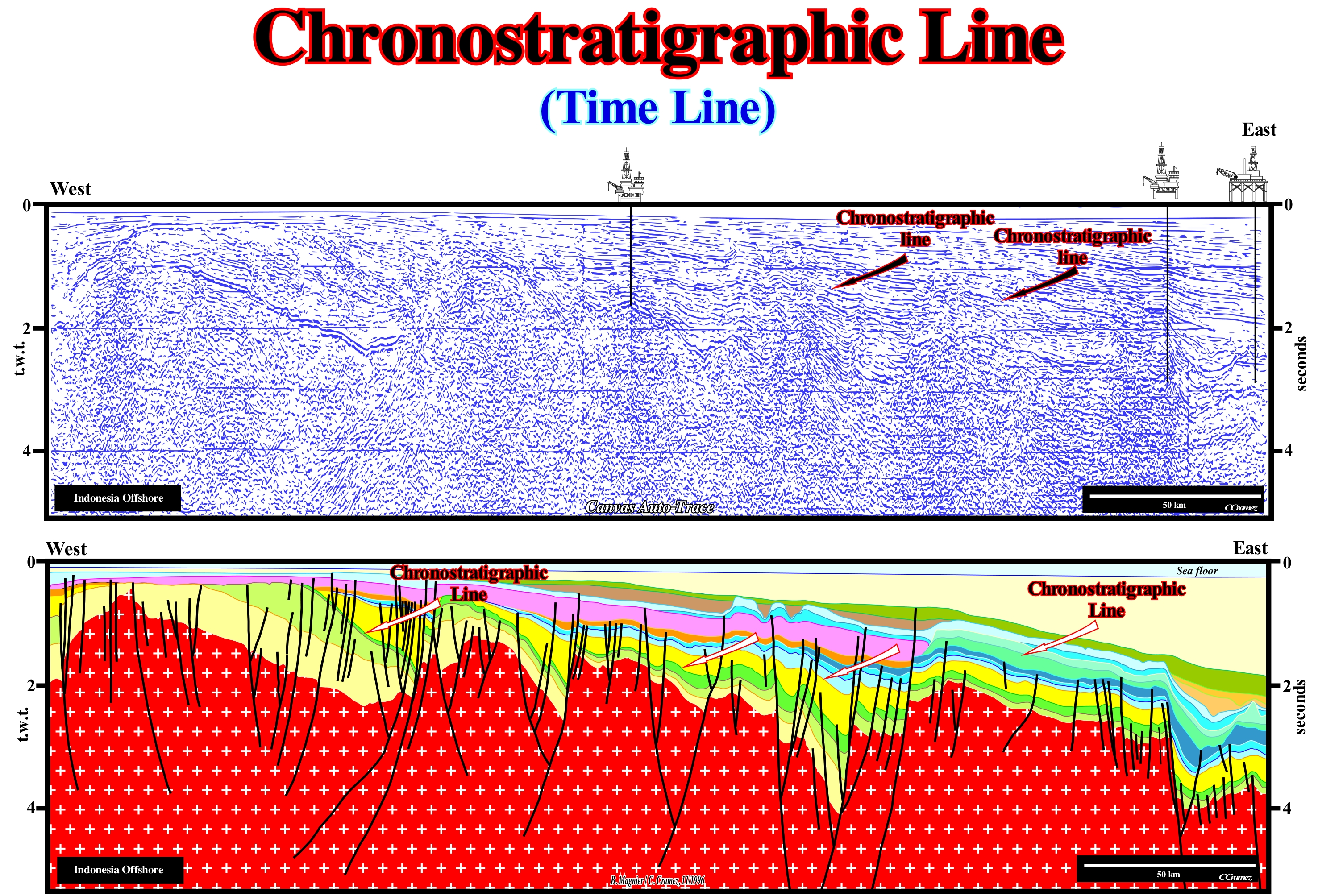
A chronostratigraphic line is by definition a depositional surface along which the sedimentary particles are deposited in a synchronous manner and function of the sedimentary environment. In a chronostratigraphic line, several slope's breaks of the depositional surface can be evidenced. From the land to the deep-sea, the first major slope's break of the depositional surface is the bayline. It separates the fluvial environments (upstream) from the paralic environments. The bay-line was defined by Posamentier and P. Vail (1988) on the basis of the following hypotheses: (i) Coastal plain is formed by processes of sea-floor progradation, rather than by exhumation ; (ii) The sediments that accumulate on the coastal plain during the seaward progradation of the shoreline are part of what they called "coastal wedge or coastal prism", which includes fluvial and shallow-water deposits ; (iii) The coastal prism is wedge-shaped and extends continentward by onlapping on the pre-existing topography ; (iv) The upstream boundary of the coastal wedge is the bayline, which can move upstream when the shoreline progradation is accompanied by aggradation and upstream of which, relative sea level* changes have, practically, no influence on depositional systems. The second major slope's break of the depositional surface (chronostratigraphic line) is the shoreline (more or less the depositional coastal break) that separates marine from non-marine environments. The third slope's break corresponds to the continental edge, which can mark the basin edge or the coastline, when the geological conditions are lowstand**. When the geological conditions are highstand, the basin has a shelf. In this case, the basin edge does not coincide with shoreline since the basin has a shelf. In this case, the basin edge coincide with the continental edge, which is marked by the slope break located between the upper part of the continental slope and the distal zone of the shelf, that means that is individualised by the coastal break, that corresponds, roughly, to the upper part of the prodelta. In this particular case, we should also consider the slope's break of the depositional surface that underlies the base of the prodelta, where, sometimes, proximal turbidite systems are deposited in association with failures and slumping of the delta front. The most distant slope break of the depositional surface corresponds to the boundary between the bottom of the continental slope and the abyssal plain. It is from this slope break that the submarine basin floor fans and submarine slope fans are deposited, when a significant relative sea level fall takes place (development of an unconformity, surface of erosion, and its deep-water correlative paraconformity. On seismic lines, as shown in this figure, the great majority of seismic reflectors correspond to chronostratigraphic lines and not, as theoretically one could expect, to facies-lines. On the seismic lines, the chronostratigraphic lines (time-lines) cut the facies-lines (lithological lines). This tentative geological interpretation was made on an automatic Canvas auto-trace of an Indonesian offshore seismic line. Several basins of the classification of the sedimentary basins of Bally and Snelson (1980) can be recognized above basement which, generally, corresponds to a Paleozoic continental crust: (i) A back-arc basin, in which a rifting or lengthening phase is, readily, recognizable, and covered by a sag phase, characterized by a thermal subsidence ; (ii) A divergent non-Atlantic margin associated with the oceanic expansion that created the South China Sea (marginal sea of the Pacific Ocean, which comprises the area from Singapore to the Taiwan Strait, i.e., around 3500,000 km2. The tiny islands of the China Sea form an archipelago of hundreds of islets.
(*) Sea level, local, referenced to the base of sediments (top of the continental crust) or the sea-floor. Relative sea level is the result of the combined action of absolute or eustatic sea level (supposed global and referenced to the Earth's centre) and tectonics (subsidence or uplift of the sea-floor).
(**) When the sea level is lower than the basin edge. The basin has no shelf. The continental edge corresponds, roughly, to the last basin edge of the previous sequence-cycle, mainly in the seismic lines, taking into account the seismic resolution.
Chronostratigraphic Unit.................................................................................................Unité chronostratigraphique
Unidade cronostratigráfica / Unidad cronostratigráfica / Chronostratigraphischen Einheit / 年代地层单位 / Хроностратиграфическая единица / Unità cronostratigrafica /
Set of rocks or strata representing the rocks or strata formed during a specific interval of geological time. The Cretaceous System (chronostratigraphic unit or Cretaceous chronozone) was deposited during the Cretaceous Period (geochronological unit or Cretaceous chron)
See: « Stratigraphy »
&
« Biostratigraphic Unit »
&
« Lithostratigraphic Unit »
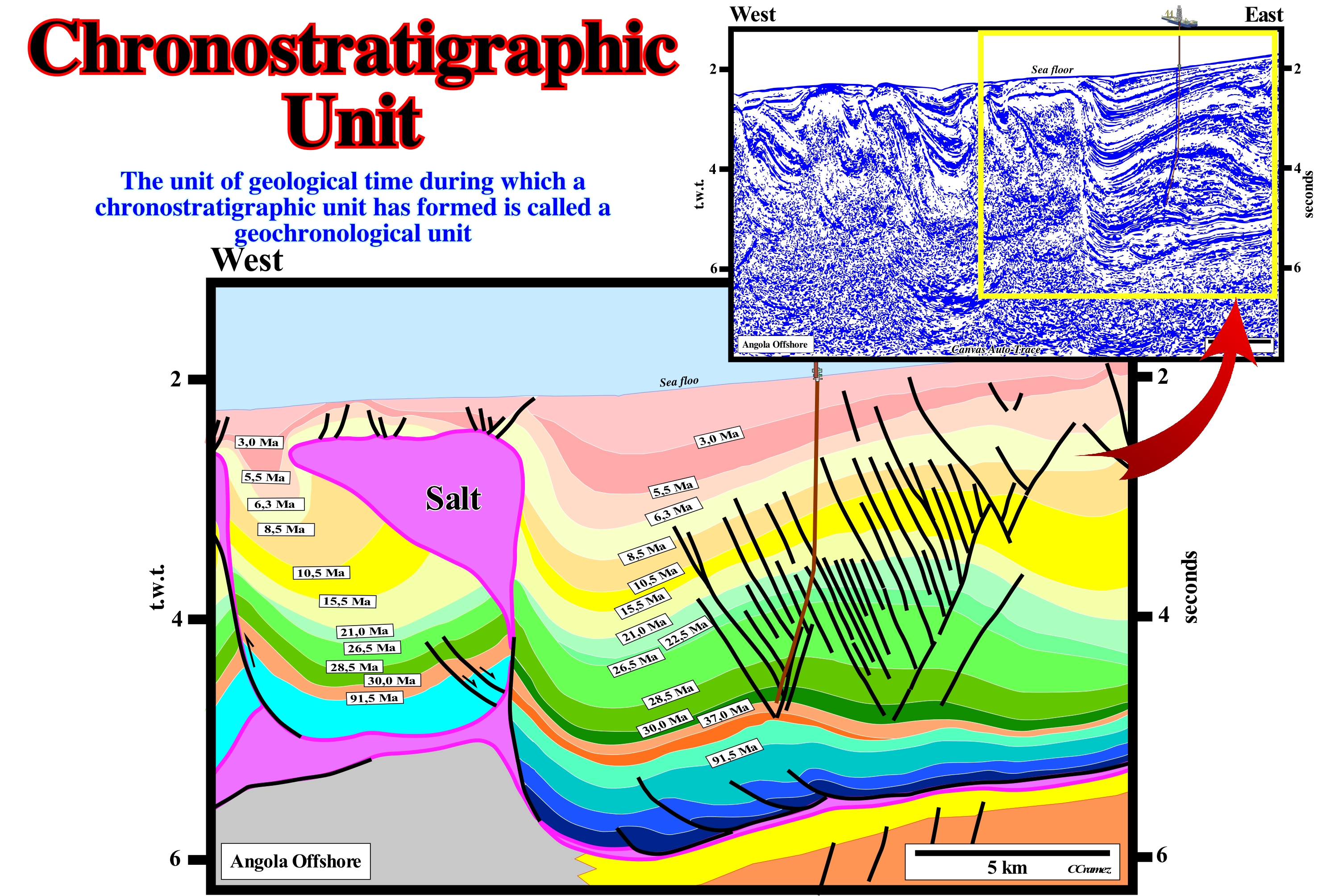
The strata can be sub-divided according to the physical characteristics, the fossils that they contain and the spatial relations between them. Three types of stratigraphic units are, generally, considered: (i) Lithostratigraphic; (ii) Biostratigraphic and (iii) Chronostratigraphic. A lithostratigraphic unit can be formed by sedimentary, igneous, metamorphic rocks and, in some cases, by an alternation of these types of rocks, which means that a lithostratigraphic unit corresponds to a three dimensions rocky body, since the concept of lithostratigraphic unit is applied vertically and laterally. A biostratigraphic unit is a set of rocks or strata unified by their fossils or paleontological characteristics, which differentiate them from adjacent rocks or strata. It can be defined by : (a)The presence of fossils ; (b) The type of fossils it contains or, just, by the fossils of a certain type ; (c) A taxon, which is a taxonomic unit, essentially associated with a scientific classification system, which may indicate a unit at any level ; (d) A particular association of fossils ; (e) The distribution of taxon or fossil taxa ; (f) The abundance of certain species of fossils ; (g) The morphological characteristics of the fossils ; (h) The way of life and habitat of fossilized organisms ; (i) The stages of evolutionary development of fossils ; (j) The variations of other factors related to the fossils that the strata contains, etc. A chronostratigraphic unit measures the geological time, whose scale is based on the time-series of the main geological events that have occurred on Earth since its formation (about 4.6 Ga). The main chronostratigraphic units are Era, Period, Epoch and Age, which correspond, respectively, to the chronostratigraphic units, Group or Erathem, System, Series, and Stage or Substage. Chronostratigraphic units can be used on the tentative geological interpretation of seismic lines, but must be, imperatively, tested and calibrated by exploration well's results. A chronostratigraphic unit, as illustrated on this tentative geological interpretation of a Canvas auto-trace of a deep offshore seismic line (northern Angola), represents all the rocks formed during a certain time interval. For each term used to denote a chronostratigraphic unit (sedimentary interval) there is an equivalent geochronological term (time interval). The Cretaceous System (chronostratigraphic unit, i.e., sedimentary unit) encompasses all the rocks formed during the Cretaceous Period (geochronological unit, i.e., time). In the same way, the Upper Cretaceous is a chronostratigraphic unit, which means the set of rocks formed during the Late Cretaceous or Terminal (geochronological unit). A geoscientist can only make chronostratigraphic subdivisions if she/he has the possibility to recognize time markers. If this is the case, the number and type of rocks or strata belonging to a particular chronostratigraphic unit can vary, greatly, from place to place. The only criterion, really, valid to include strata within a chronostratigraphic unit is the age of these strata fell within the time span that characterizes it. On tentative geological interpretations of the seismic lines, with few exceptions, the reflectors, like the seismic surfaces defined by the reflector terminations (unconformities, downlap surfaces, etc.) correspond to chronostratigraphic lines. The knowledge of the stratigraphic signature of the geological systems (chronostratigraphic units) facilitates, greatly, the tentative geological interpretation of the seismic lines in stratigraphic cycles, which are chronostratigraphic units limited by time lines (unconformities). The actual deposition time of a stratigraphic unit limited between two unconformities, as in this tentative interpretation the interval limited between the 8.5 Ma and 10.5 Ma dislocations, does not correspond to the age difference of the unconformities. The actual deposition time is much smaller. The geoscientist has to have an idea of the completeness (relation between the actual deposition time and total geological time) of the sedimentary interval considered, as for instance to calculate the sedimentation rate (time required to deposit a layer of a certain thickness). In Angola offshore, the completeness of turbidite deposits is about 0.1 / 0.2.
Chronostratigraphy (Example)................................................................................................Chronostratigraphie (Exemple)
Cronostratigrafia / Cronostratigrafía (ejemplo) / Chronostratigraphie / 年代地层 / Хроностратиграфия / Cronostratigrafia /
Stratigraphy that sub-divides a sedimentary section into different composite units of all sediments deposited during a given geological time interval. The chronostratigraphy implies: (i) The stratification plans represent different periods of time ; (ii) The stratification plans represent at least a small unit of time that applies to the entire extent of the stratification surface and (iii) The concept of stratification plane is dependent on the scale and geological time considered.
See: « Geological Time »
&
« Magnetostratigraphy »
&
« Stratigraphy »
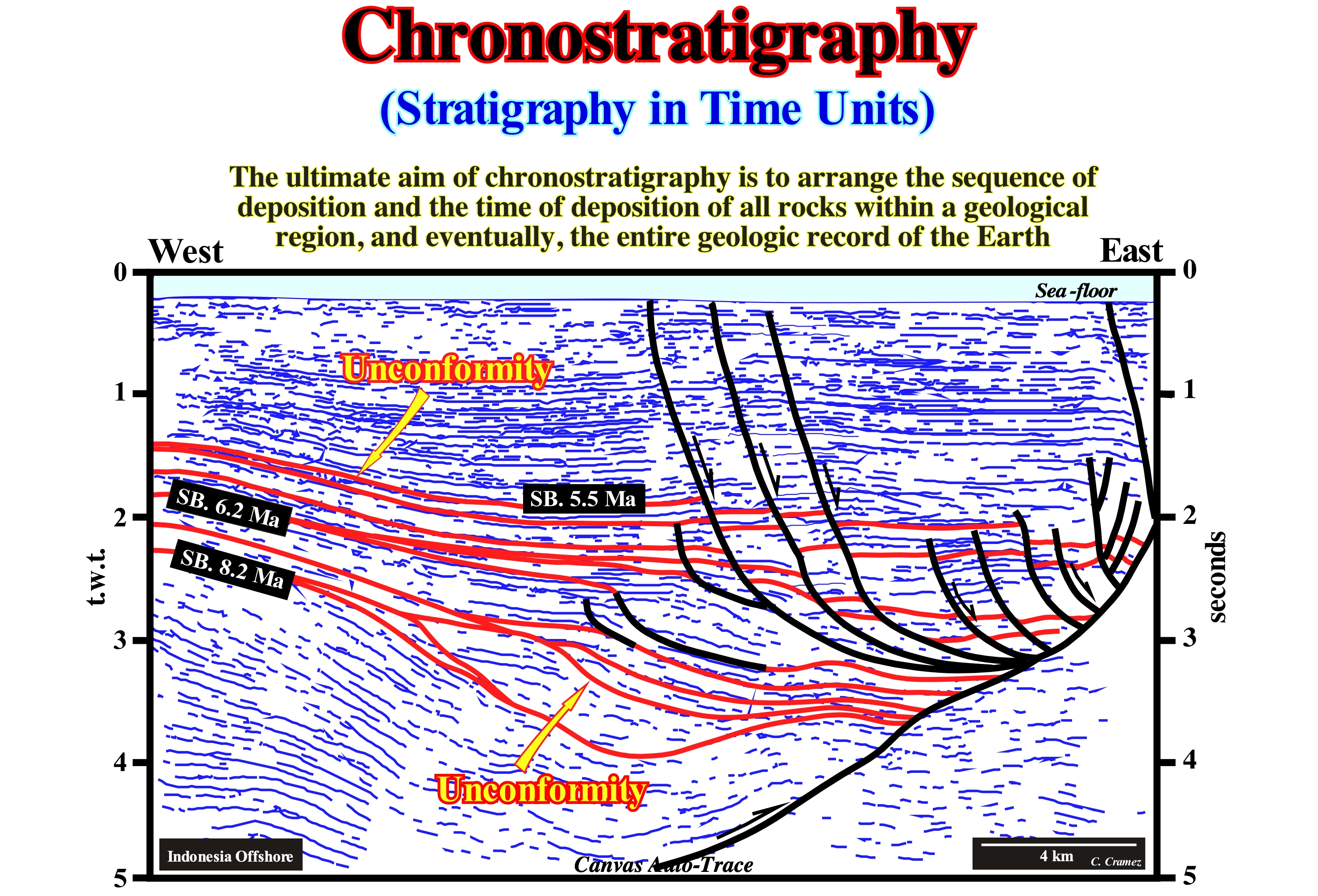
On this tentative of geological interpretation of Canvas auto-trace of an Indonesian offshore seismic line (Mahakam, Borneo), it is easy to see an stacking of several sedimentary intervals that have been interpreted as stratigraphic cycles called sequence-cycles. These cycles are limited by unconformities (erosional surfaces induced by significant relative sea level falls) and deposited in association with 3rd order eustatic cycles, i.e., eustatic cycles lasting between 0.5 and 3-5 My (between 0.5 and 3 My to P. Vail). This means that the age difference between the upper and lower unconformity limiting a sequence-cycle, can not be greater than 3-5 My. If the difference is greater than 3-5 My, the stratigraphic cycle is not a sequence-cycle, but a continental encroachment sub-cycle*. On this tentative interpretation, between the unconformities SB 8.2 Ma, SB 6.2 Ma and SB 5.5 Ma (SB stands for "Sequence Boundary"), it is possible to recognize, at least locally, relative sea level falls, and thus to consider, sequence-cycles that do not exist, regionally, and, in particularly, in the chart of coastal onlaps proposed by Exxon (P. Vail). As can be seen, this tentative interpretation is made in chronostratigraphic packages. The chronostratigraphic units considered are seismic intervals correlated to a set of rocks deposited during a specific geological time interval, which implies these intervals are limited by horizons of the same age. At the geological time scale (during the Phanerozoic, for instance, which lasted about 600 My), an unconformity and a sequence-cycle are instantaneous geological events. Their time-duration is less 1/100** of the Phanerozoic total time, i.e., less that 6 My. It is for this reason that the time-span of a sequence-cycle is considered less than 6My (0.5 and 3-5 My).
(*) In sequential stratigraphy four type of stratigraphical cycles are considered: (i) Continental Encroachment Cycles, induced by 1st order eustatic cycle (time duration higher than 50 My ; (ii) Continental Encroachment Sub-Cycles, induced by 2nd order eustatic cycle (time duration between 3-5 My and 50 My) ; (iii) Sequence Cycles, induced by 3th order eustatic cycles (time direction between 0.5 My and 3-5 My) and (iv) High Frequency Cycles, induced by 4th and higher order eustatic cycles (time-duration less than 0,5 My).
(**) Mathematically, an episodic geological event is characterized by a time-duration, rarely, exceeding 1/100 of the total time considered. In other words, when one expresses, graphically, an episodic geological event (change versus time), it represents just the thickness of the pencil line.
Chronostratigraphy (Time rock stratigraphy)................................................................................Chronostratigraphie
Cronostratigrafia / Cronoestratigrafía / Chronostratigraphie / 年代地层 / Хроностратиграфия / Cronostratigrafia /
Stratigraphy that sub-divides a sedimentary section into different composite units of all sediments deposited during a given geological time interval. The chronostratigraphy implies that: (i) The stratification plans represent different periods of time ; (ii) The stratification plans represent at least a small unit of time, which applies to the entire length of the stratification surface and (iii) The concept of stratification plane depends on the scale and geological time considered.
See: « Geological Time »
&
« Magnetostratigraphy »
&
« Stratigraphy »
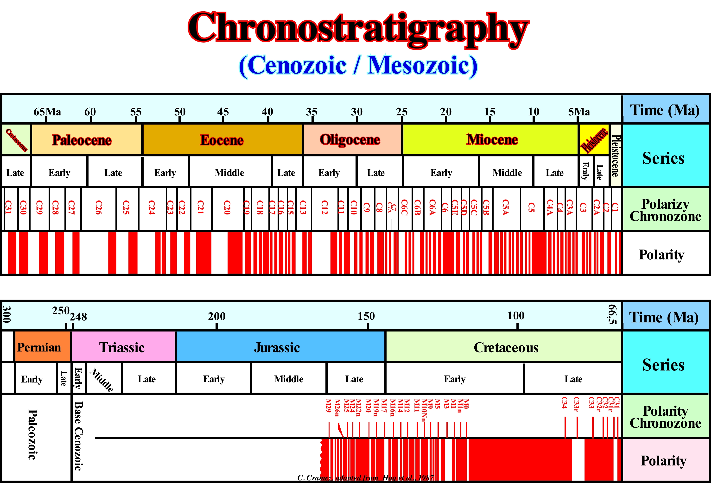
The idea behind chronostratigraphy is to correlate the rocks formed at the same time. This is useful for rebuilding deposition events and environments in Earth's history, as well as, to find features such as petroleum or gas. There are several techniques that can be used for chronostratigraphy (https://geo.libretexts.org/LibreTexts/UCD_GEL_109% 3A_Sediments_and_Strata/Chronostratigraphy) such as: (i) Event stratigraphy ; (ii) Magnetostratigraphy ; (iii) Chemostratigraphy ; (iv) Biostratigraphy ; (v) Sequential stratigraphy. Event stratigraphy consists of identifying the sedimentary effects of an event, relatively, rare in multiple stratigraphic columns, i.e., if a geoscientist shows the effects were all produced by the same, it can reasonably be suggested that the effects happened, more or less, at the same time in the different columns. Magnetostratigraphy uses the magnetization preserved in the rocks for correlation, since magnetization comes from the alignment of magnetic minerals in sedimentary rocks (and other types of rocks) with the Earth's magnetic field. This means that small minerals magnetic, especially the size of the clay, are aligned as small magnets, and that when the sediment is lithificated, this magnetization can be preserved (under suitable conditions, samples can be collected and the direction of magnetization measured). Chemostratigraphy corresponds to the study of chemical variations within sedimentary intervals to determine stratigraphic relations, since different chemical signatures may be as useful as fossil assemblages or the lithologies in the establishment of stratigraphic relations between the different layers of rocks. Biostratigraphy, in which the geoscientist identifies fossils in the stratigraphic columns and compares them with the distribution of these species known by previous works. Sequential stratigraphy, i.e., the stratigraphic interpretation that combines the architecture of the sedimentary layers (geometric relationships), within a geometric frame assuming the repeated filling of available space for sediments (accommodation) as the consequence of relative sea level changes (referenced to the sea-floor or to the base of the sediments). In this Mesozoic/Cenozoic chronostratigraphy, which was proposed by Haq et al. (1987), Pliocene to Triassic series are correlated in absolute time (Ma), chronozone (rocks formed during a certain period of time as a chron) and polarity. A chronozone is, generally, defined geologically and, for a geographic area, by the names of fossils (biozone or biochronozone) or, globally, by geomagnetic inversion identifiers (chronozone of polarity). At present, chronostratigraphy relies, heavily, on isotopic geology and geochronology to date rocky units that are characterized by a set of guide fossils (fossils that identify and date a layer, in which they are typically found). Chronostratigraphy is based, mainly, on paleontological time intervals defined by a set of fossils and on the law of superposition (in a non-or slightly deformed sedimentary series, the oldest layers are at the base and the most recent layers, successively, above). The main chronostratigraphic units are: (i) Enothem (e.g., Phanerozoic rocks) ; (ii) Erathem (e.g., Mesozoic rocks) ; (iii) System (e.g., Cretaceous rocks) ; (iv) Series (e.g., Late Cretaceous rocks) ; (v) Stages (e.g., Maastrichian rocks). It is important not to confuse chronostratigraphic units (stratigraphy, i.e., rocks) with geochronological units (chronology, i.e., time). The first are a geological material (rocks) and the second, i.e., the geochronological units are units of time. For instance, it should be said "This fossil is characteristic of the Cretaceous System (chronostratigraphic unit) or this fossil lived during Cretaceous Period" and not "This fossil is characteristic of the Cretaceous Period or this fossil lived in the Cretaceous System". In the same way, it is evident that Lower Cretaceous is not synonymous with Early Cretaceous. Lower Cretaceous is used for rocks, such as "Lower Cretaceous shales", while Early Cretaceous is used for time intervals: "During the Early Cretaceous, the average global temperature was about 17° C and today it is about 12° C". Chronostratigraphy is a very important branch of stratigraphy. A good correlation between the ages of the different rocks is a sina qua non condition, to propose tentative geological section and consistent paleogeographic reconstructions, that is to say, difficult to refute and not, necessarily, exact. In science, the truth does not exist. In geology and, particularly, on the tentative geological interpretation of the seismic lines, a tentative interpretation can just be corroborated or refuted (falsified) and never verified (coming the Latin word verus, meaning true).
Chronozone.....................................................................................................................................................................................................................Chronozone
Cronozona / Cronozona / Chronostratigraphischen Zone / 年代地层区 / Хронозона / Cronozona /
Chronostratigraphic unit without defined hierarchy or, in other words, a set of sedimentary rocks formed, anywhere, during a given time interval of any stratigraphic unit or geological event. The corresponding geochronological unit is the chron. A chronozone is, generally, based on a biozone (stratigraphic unit). It can be used as (i) A relative chronological value (prior or posterior to another chronozone) or as (ii) An absolute chronological value, which means that its limits are defined by numerical dating.
See: « Geological Time »
&
« Facies »
&
« Chronostratigraphy »
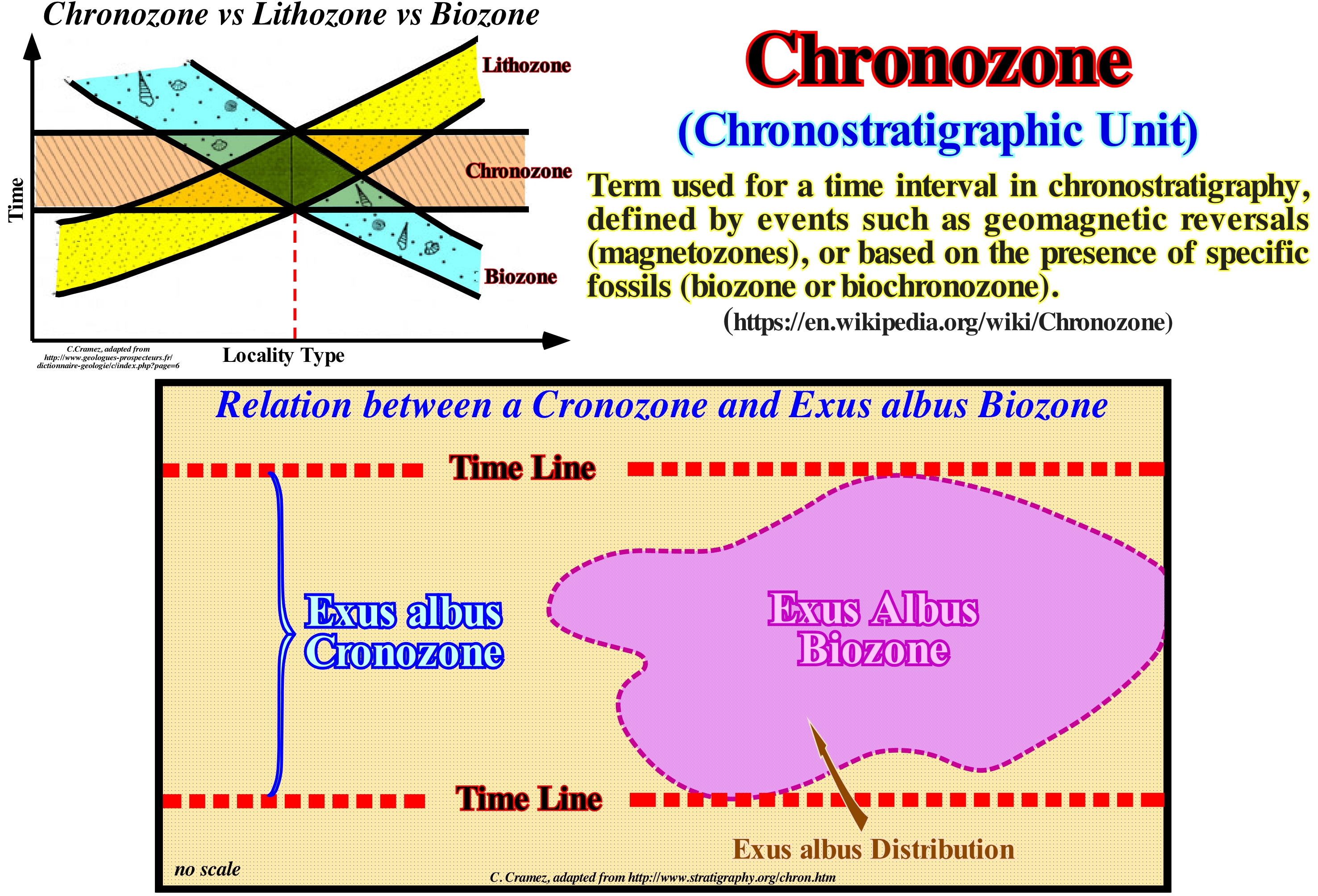
Two definitions of chronozone, partially, contradictory, were proposed. According to the first, the chronozone is the lowest ranking unit (the elementary sub-division) in the chronostratigraphy hierarchy. The second defines this unit as a formal chronostratigraphic unit of unspecified ranking, which is not part of the hierarchy of conventional chronostratigraphic units. According to this definition, chronozone is the body of rocks formed anywhere during the time interval of a designated stratigraphic unit or geological event (https: // books.google.ch/books? ISBN = 2710809109). The time interval of a chronozone, i.e., the chron, is the time interval of the chosen stratigraphic unit, whether it is lithostratigraphic, biostratigraphic or magnetostratigraphic (polarity). The stratigraphic unit, on which a chronozone is based, extends, geographically, until its own characteristics disappear. The corresponding chronozone includes all the rocks formed (no matter where) during the time-period represented to designate the stratigraphic unit. A chronozone based on the time-interval of a biozone includes all layers equivalent to the age of the maximum time interval of the biozone, despite the presence or absence of typical biozone fossils. Chronozones may have very different time intervals. The limits of a chronozone and the time interval may be determined in various ways depending on the nature of the stratigraphic unit on which chronozone is based. If the unit has a certain strato-type, the limits and time interval of the chronozone may correspond to those of the stratigraphic unit of its strato-type (succession of well defined rock layers, used as a reference, and in the characterization of stratigraphic units, i.e., a stratigraphy is neither more nor less than a stratigraphic succession, but for this succession to ascend the strato-type has to be approved by authorized geological correlation committees) or the total time interval of the unit, which may be longer than that of the strato-type. In this second case, the limits and time interval of the chronozone vary with the knowledge of the limits and time interval of the stratigraphic unit. If the unit on which chronozone is based can not be designated as a strato-type, but as a biostratigraphic unit, the limits and the time interval can not be defined, since the time interval of the reference unit changes as geological information increases. Chronozone based on the extent of a given taxon should be, clearly, distinguished from the biozone based on the extent of that taxon*, that is, the taxon's area of extension. The vague use of both the term "zone" without any qualifier gives rise to many confusions. Chronozones can be of very different time intervals. One can speak of the ammonites chronozone (extinct group of cephalopods molluscs that appeared in the Devonian and disappeared in the extinction that occurred at the end of the Cretaceous, which include all the strata formed in the long interval of time during which the ammonites existed, irrespective of the layers containing ammonites. In the diagram "Time versus Locality" type are represented the relations between the concepts of lithozone, biozone and chronozone. The extent of the Exus albus biozone (extension zone) is limited to strata containing Exus albus specimens. The chronostratigraphy of Exus albus (chronostratigraphic unit) includes all strata, in all parts, equivalent in age to that represented by the total vertical extent of Exus albus, containing specimens of Exus albus or not. In other words, a chronozone of a taxon is the entire sedimentary interval limited between the time limits of the appearance and extinction of this taxon, whereas the biozone of this taxon is exclusively the set of strata that contains it.
(*) According to Wikipedia, taxon is a conceptual entity which is supposed to group all living organisms that have some well defined taxonomic or diagnostic characters in common. In classical classification, the characters of a taxon are considered homogeneous according to their taxonomic ranking, their "weight" (relative taxonomic value) being left to the taxonomists' appreciation. In more modern classifications, such as phylogenetic classification, many of the old taxa are no longer used because they cover artificial groupings (paraphyletic) or structured vernacular concepts (e.g. reptile), insufficiently: clads (group of organisms originated of a single unique common ancestor) are used that fit into each other, which corresponds, in fact, to monophyletic groups. The species is the basic taxon of the systematic classification. The higher the taxon rank, the greater the degree of similarity (the number of characters they have in common) of the individuals concerned (plants, animals, fungi, bacteria) is weak and vice versa.
Chute Cutoff (Neck)....................................................................................................................................................................................Goullote (Méandre)
Atalho de meandro / Atajo de meandro / Rutsche, Cutoff / 槽或截止, 在一条河, 跨的快捷方式 menader / Шейка меандра / Scivolo, Cut-off /
Small narrow channel through the curve of a meander formed during a flood when the main river flow is diverted to a depression between the meander bars. When a river cuts through the narrow throat of a meander. Also, sometimes, called, simply, Neck or Meander Neck.
See: « Meander »
&
« Point Bar (fossil) »
&
« Bay-line »
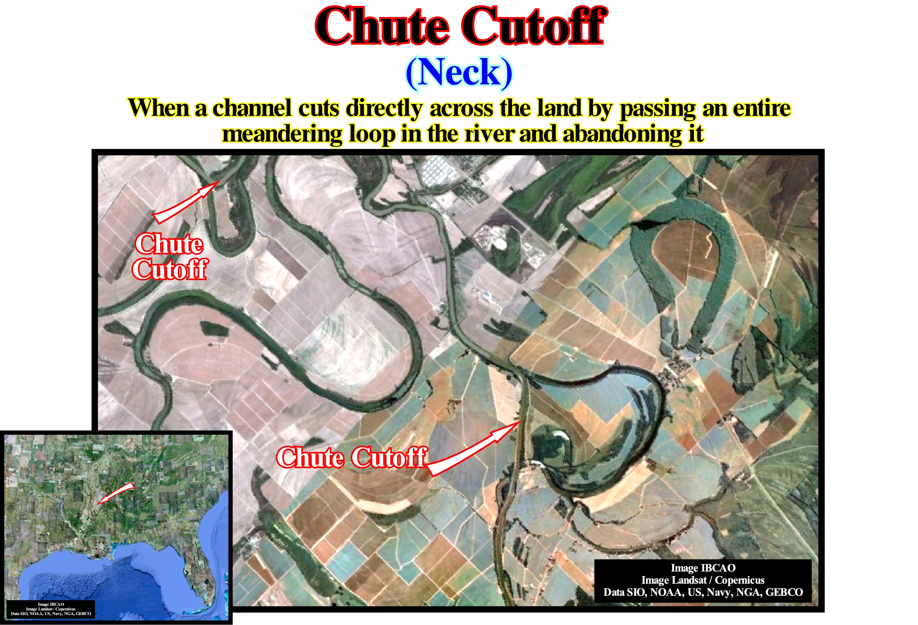
When a river bend intersects itself, geoscientists call it neck cutoff. On the outer bends of a river, where water is flowing fastest, the river will erode away the land between adjacent outer bends and cause them to become close to each other. This leads to their intersection. In this figure, it is easy to understand that a meander chute cutoff is associated with the rupture of the river bed near the meander's neck cutoff. This rupture is due to the path of least resistance (*), which controls all geological events, and which, in this particular case, forces the river stream to travel less space. When a meander is abandoned, in general, a lake is formed, which is called meander lake. Since the provisional equilibrium profile of a river becomes more or less horizontal, under normal conditions, since a river loses its competence** and capacity *** it begins to zigzag forming meanders, more or less, tight. The erosion is located in the concave part of the meander, whereas in the convex part a sandy bar (point-bar) is formed. In flood periods, the energy and competence of the river increases substantially allowing the formation of meanders chute cutoff and abandoned meander channels. In most cases, chute cutoff and abandoned meander channels are not definitive. Since conditions normalize, the river can return to its original bed. However, as the deposition of point-bars (when the river is active) and clay plugs (when the meander is abandoned) fill, progresss, the river channel is abandoned, permanently, and the chute cutoff becomes the new bed of the river. From the point of view of the sequential stratigraphy, it is important to note that the disconformities (defined by the onlapping, for instance) observed in the deposits associated with the meanders (point-bars and clay-plugs) do not correspond to unconformities (stratigraphic cycle boundaries). Erosion erosion (in the concave part of the meander) and the deposition in the convex part of the meander (point-bar) are synchronous. In other terms, there is any erosional surface induced by a significant relative sea level fall. The deposits are not associated with an increase of accommodation, i.e., an increasing of the space available for the sediments (marine ingression).
(*) The path of least resistance is the physical pathway that provides the least resistance to forward motion by a given object or entity, among a set of alternative paths. The concept is often used to describe why an object or entity takes a given path. The way in which water flows is often given as an example for the idea. (https://en.wikipedia.org/wiki/Path_of_least_resistance)
(**) The competence of a river or stream refers to the largest particles that a river can transport. Rivers and streams carry sediment that ranges in size from clay to boulders. As the velocity of the river increases it is able to transport larger particles and so its competence increases.
(***) The capacity of a river is the maximum load that it can transport. Capacity increase with increasing discharge (volume of water flowing through a river channel) and velocity.
Chute Cutoff (Evolution)........................................................................................................................................................Coupure de Goulotte
Atalho de meandro / Atajo de meandro / Rutsche, Cutoff (Mäander) / 槽或截止 / Прорезь в перешейке / Scivolo, Cut-off, Collo di meandro /
Small narrow channel through the curve of a meander formed during a flood when the main river flow is diverted to a depression between the meander bars. When a river cuts through, the narrow throat of a meander. Also, sometimes, called, simply, Neck or Meander-Neck.
See: « Meander »
&
« Deltaic Plain »
&
« Point Bar (Model) »
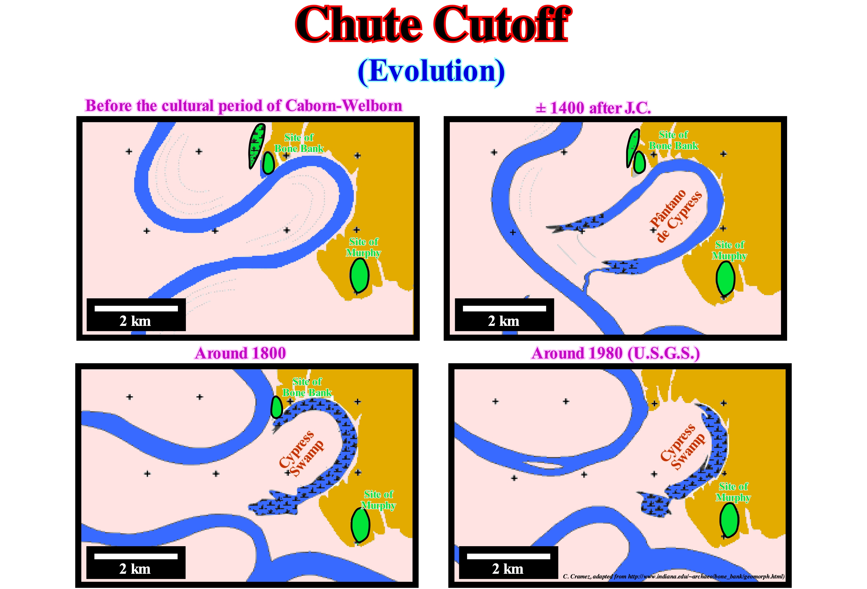
These maps illustrate the morphological changes that the area of the Bone Bank archaeological site has undergone during the last millennium. At the moment, the meander lake (Cypress swamp), that is filled, mainly, by alluvium is to the South and East of the site. Before the Caborn-Welborn civilization, about 1,700 years ago, the Wabash River ran along, more or less, tight meanders. However, by the beginning of the fifteenth century, the river cut the narrow throat of a meander by a chute cutoff individualizing a meander-lake (Cypress Swamp lake). Today, as illustrated in the USGS map, the morphology is quite different from that of 1807. In reality, for about 200 years, a meander has, continually, destroyed the western margin of the archaeological site. The formation of point-bars and the filling, by shaly sediments, of the abandoned meanders (clay-plugs*) are not associated, at least directly, with relative sea level changes, i.e. relative sea level rises which increase the space available for sediment. Similarly, the erosion of meander banks (the concave part of the meander) is not induced by relative sea level fall. In this type of sedimentary environment, deposition and erosion are local phenomena, directly associated to the flow velocity of the water-course, which is greater in the external part (where there is erosion) than in the internal part where there is deposition (point-bar). Thus, the terminations of the bedding planes (onlaps) observed in the point-bars and the clay-plugs (which are often well visible on seismic lines, particularly on 3D lines) do not define erosional surfaces, i.e., unconformities induced by significant relative sea level falls. In other words, these surfaces (stratigraphic or seismic) do not limit stratigraphic cycles. The influence of relative sea level changes is here little meaningless.
(*) Fluvial reservoirs may be partially or totally compartmentalized by abandoned channel mud plugs. A meander loop can be cut off by the river breaking through into a new course during a flood. The abandoned meander channel is, quickly, isolated from the river flow, typically forming lakes and ponds for a period of time. The channels slowly fill up with clay, silt, and peaty organic material. Mud-plugs are crescentic in plan view and lenticular in cross section. They are narrow with widths of tens to hundreds of meters. A meander belt may contain many individual mud plugs, which can collectively make up a large volume of the total system. In a study area comprising 16 billion m3 of a meander belt in the modern day Mississippi River, Jordan and Prior estimated that 11.1 billion m3 of this volume comprises point bar and splay sandstones and the remaining 4.9 billion m3 consists of clay plugs within numerous abandoned channels. Clay plugs can be difficult to recognize in the subsurface. It is sometimes possible to identify them on correlation panels if the wells are closely spaced. They can also be picked out from amplitude displays on good quality seismic data. (http://wiki.aapg.org/ Meandering_fluvial_reservoirs#Mud_plugs)
Clade.......................................................................................................................................................................................................................................................................Clade
Clado / Clado / Clade /单系类群 / Монофилетический таксон / Clado /
Group composed of a single ancestor and all his descendants. The ancestor may be an organism, population or species. The common ancestor of a group of significant size and many of their descendants must have disappeared (extinct) since a long time.
See: « Animal Kingdom »
&
« Paleontology »
&
« Fossil »
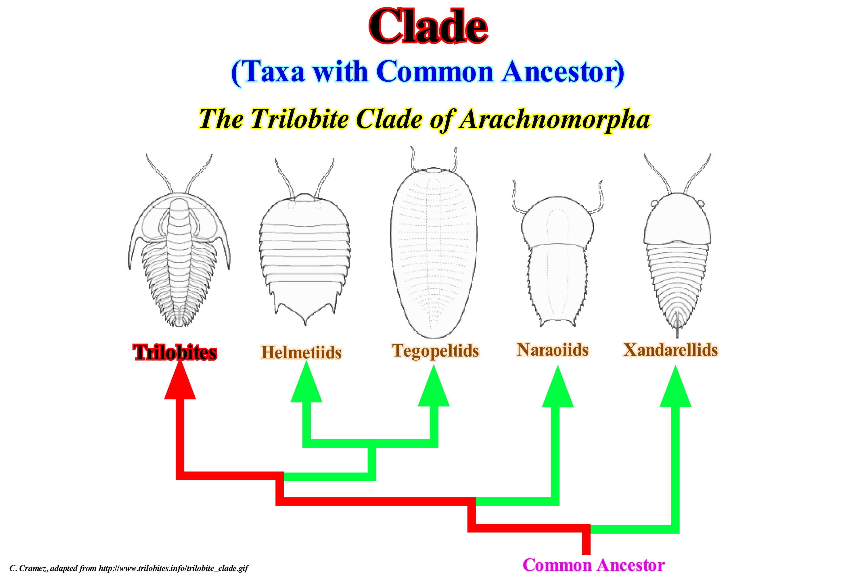
Before Darwin, in Lineu's taxonomy, the concept of clade did not exist. Taxonomy was based primarily on morphological similarities between organisms. Although many of the best-known groups of animals in the original Linnaeus system (such as certain clusters of vertebrates) represented clades. With the publication of Darwin's Theory of Evolution (1985), taxonomy has acquired a theoretical basis and the idea that systematic units represent branches of the evolutionary tree of life. For a century and a half, taxonomists (geoscientists practicing the science of classification) work in a way that the classification system translates evolution. Since the tree of the different branches of Life is quite unequal, the hierarchy of the Lineu system does not always lend itself well to representing the clades. As far as terminology is concerned, the cladistic and Lineu taxonomy are not always compatible. The top-level taxa in the Lineu taxonomy often represent evolutionary degrees rather than clades (where one or two sub-branches were excluded). In phylogenetic nomenclature, clades can be introduced at any level and do not have to be embedded in a global hierarchical position. In contrast, Lineu's units of "order," "class," etc., should be used when calling a new species. As there are only seven formal levels in the Lineu system (the species is the lowest), there are a finite number of sub- and super-units. As taxonomic trees (or cladograms) are increasingly detailed. Some scientists have chosen to use all divisions together, using the names of the clades without the Lineu divisions. The preference of one system over another is only a matter of application. The cladistic systems give details, but they require deep knowledge. The Lineu system gives a well-ordered overview, but to the detriment of the details of the phylogenetic tree.
Clastic Wedge......................................................................................................................................................................................................Coin clastique
Cunha clástica / Cuña clástica / Klastische Keil / 碎屑岩楔 / Обломочный клин / Cuneo clastico /
Sedimentary wedge deposited towards the foreland of an active mountain range. For some geoscientists, the clastic wedge is synonymous with the Foreland Basin.
See: « Foreland Basin »
&
« A-Type Subduction (Ampferer) »
&
« Flexural Subsidence »
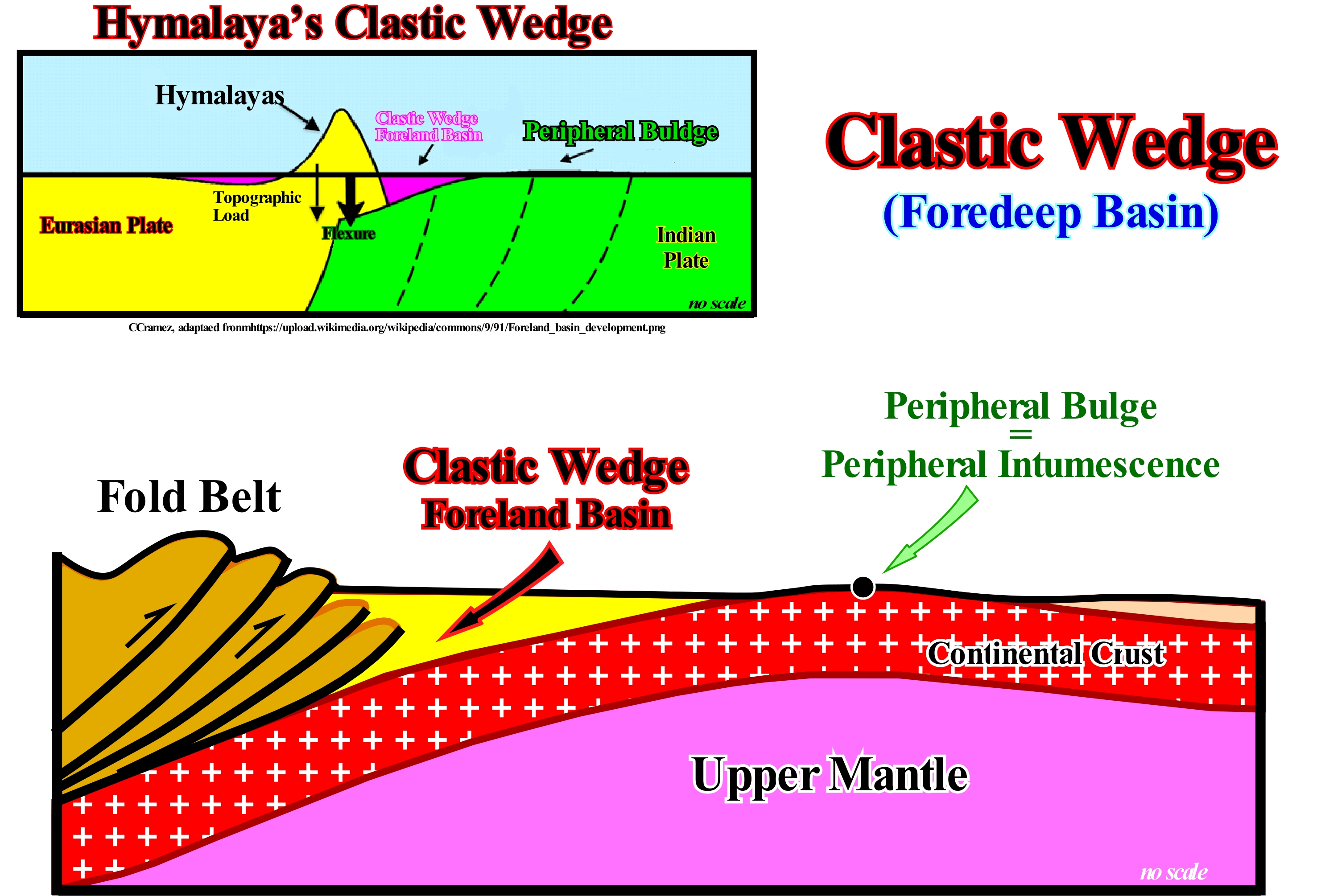
Clastic wedges correspond to what certain geoscientists call foredeep or foreland basins, in which subsidence is controlled by mechanical geological processes rather than by thermal processes. In foreland basins and, above all, when sedimentary influx coming from the mountains is predominant, eustasy (changes in absolute or eustatic sea level, which issupposed to be global and referenced to the Earth's centre) has little influence in the process of creating available space for sediments (shelfal accommodation). On a divergent margin, the accommodation cyclicity, which is the available space for sediments created by the combination of absolute (eustatic) sea level and tectonics, is mainly controlled by absolute sea level changes, since they create cyclical relative sea level* falls or rises. In the divergent continental margins, but also in the convergent ones, sea level changes, especially, when induced by glacio-eustasy, are much faster than variations in subsidence (tectonics). However, according to some geoscientists, this does not seem to be the case in the foredeeps. In foreland basins, the subsidence of the substrate is, mainly, induced by the loading of the thrust faults associated with the folded belts, which is reinforced by the weight of the sediments (the rigidity of the substrate to flexure and the elastic thickness of the underlying lithosphere should be take into account). The origin of the loading responsible for the tectonic subsidence is not always evident. Gravimetric anomalies found in certain folded belts, as in the Himalayas, suggest that the actual topography is sufficient to explain the subsidence of the Australian-Indian lithospheric plate. However, in the Alps and Appalaches, the topography is insufficient to explain the sinking of associated clastic wedges. It is necessary to invoke "buried loading" within the crust, which may correspond to relics of the oceanic crust or mantle material riding the continental crust during the convergence of the lithospheric plates. The temporal distribution of these buried-loads is, practically, unknown. The recognition and study of clastic wedges without associated folded belts suggested to the geoscientists that buried loads are responsible for the main mechanism of creation and preservation of clastic wedges. The a priori geological conjecture is as follows: If a folded belt is brought to the erosion and if it is responsible for the loading, it disappears as erosion advances. The foreland basins will be partially eroded due to the uplift induced by the decreasing of the tectonic loading. Conversely, buried-loads are protected from erosion. Consequently, they will survive long-time inside the continental crust. As can be seen in these sketches, the clastic wedge, which deposits at the base and in front of the mountain chain, decreases in thickness toward the craton. It begins in front of the mountains, increases in thickness in the opposite direction to, rapidly and progressively become thinner toward the craton by onlapping. The geological history of clastic wedges is summarized in two geological processes: (i) A very rapid initial subsidence, followed by (ii) A sedimentary filling of the basin. The filling, in general, is not aggradational but progradational. Near the mountains, the fill is type proximal (alluvial fans, fluvial deposits and platform deposits), whereas in the more distal sectors (far from the mountains), it is made by platform and slope deposits (submarine slope fans) and from the abyssal plain (submarine cones of the basin) until entering an epicontinental sea. In the majority of cases, a foredeep covers a divergent margin (with opposite vergence) associated with the craton, that is, the two basins evolve in opposite directions. The unconformity at the base of the clastic wedge, which is, generally, very conspicuous, separates sedimentary intervals with terrigeneous influxes in, more or less, opposite directions. In the divergent margin, the origin of the terrigeneous influx comes of the craton, while the sediments that fill the clastic wedge come, basically, from the mountain range. The dimensions of a clastic wedge are controlled by the age of the lithosphere (elastic thickness) and the tectonic loading. When the lithosphere is young, the width of the basin (distance between the peripheral bulge and the outcropping of the frontal thrust) rarely reaches 50 km. The fill thickness is directly related to the tectonic loading. The greater the deep charge the greater the basin (the basin's length is more or less constant). The greater the elastic thickness of the lithosphere, i.e., the older the lithosphere, the greater the width of the clastic wedge. It can reach more than 300 km. In such a case, the thickness of the basin filling is mainly dependent on the tectonic subsidence.
(*) Local sea level, referenced to any point on Earth's surface, whether the base of the sediments (top of continental crust) or the sea-floor.
Clay............................................................................................................................................................................................................................................................................Argile
Argila / Arcilla / Ton / 粘土 / Глина / Argilla /
Any of the numerous small aluminum-silicate minerals with, more or less, laminar crystalline structure and formed either by atmospheric alteration or by hydration of other silicates. Any mineral fragment smaller than 0.0039 millimeters. Although many geoscientists use the term argile to designate a shaly rock, we prefer to reserve it for a sedimentary aparticle (granulometry).
See: « Shale (slate) »
&
« Argillite »
&
« Granulometry »
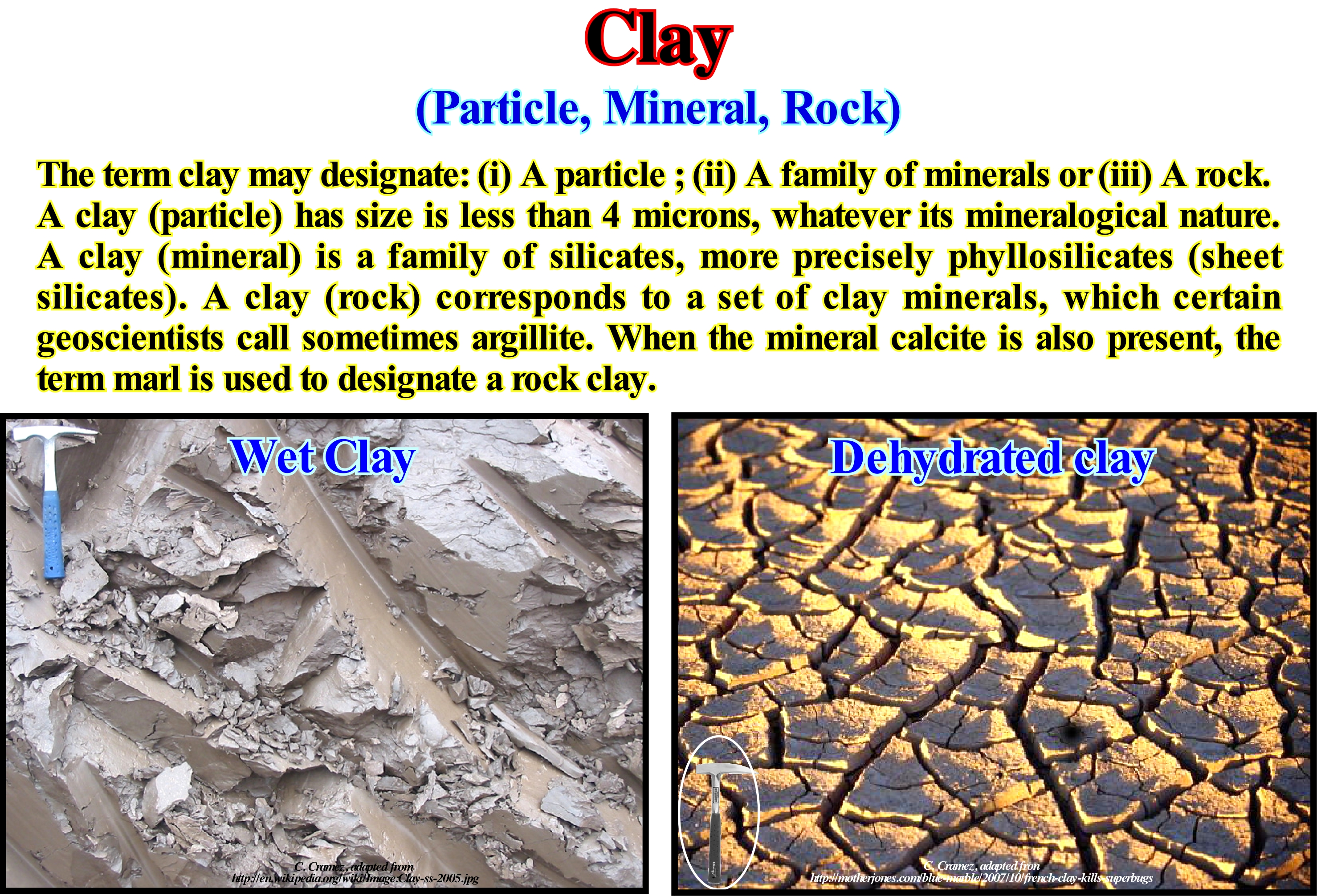
A clay, when wet is plastic (as in the right photograph of a clay from the Quaternary, Estonia), which means that it can be modelled. However, when it dries (figure on the left), it becomes hard and, when subjected to high temperatures, it is permanently transformed into an extremely hard material, which makes it an ideal substance for ceramics. Clay minerals form over long periods of time due to a gradual chemical alteration of the rocks, mainly of the silicate rocks, due to a low concentration of carbonic acid and other more or less diluted solvents. These more or less acidic solvents migrate through the altered zones of the rocks after they have undergone intense leaching. In addition to the processes of weathering (the natural process of decomposition or disintegration of rocks and soils and their mineral constituents by the chemical, physical and biological effects that result from their exposure to external agents), certain clay minerals are formed by hydrodynamics (natural phenomenon occurring, for instance, in oil fields that have a natural active aquifer that acts as energy from it, since water pushes the reservoir rock to the production wells). Clay deposits may be formed "in situ" as residual deposits, but thick clay deposits are formed mainly by secondary sedimentary re-deposition processes after they have been eroded and transported from their original deposition site. Clay deposits characterize low energy sedimentary environments, such as lakes and certain marine environments. Basically, clay deposits, known as kaolin, are found where they formed. The deposits, said secondary, are those, which have been removed by erosion and water from the place where they formed. The clays are distinguished from the other soils finely granulated by the difference in size and mineralogy of their particles. The silts, which are also, finely, granulated soils but have no clay minerals, are formed by particles larger than clay. However, there is a certain overlap, not only in particle size, but in certain physical properties. On the other hand, there are many natural deposits that include silts and clays. In any case, it can be said that the distinction between silt and clay varies with the branches considered (pedology, sedimentology, etc.).
(*) Leaching is the extraction or solubilization of the chemical constituents of a rock, mineral, soil, sedimentary deposit among others, by the action of a percolate (which passes through the soil and permeable rocks flowing into the underground reservoirs).
Clay Gouge.................................................................................................................................................................................................................Argile de faille
Argilito de falha / Arcilla de falla / Ton Beitel / 粘土泥 / Сбросовая глина / Argilla sgorbia /
Allochthonous clay which is, sometimes, found between the faulted blocks (fault zone) in normal, reverse or strike-slip faults.
See: « Footwall »
&
« Fault »
&
« Trap (oil or gas) »
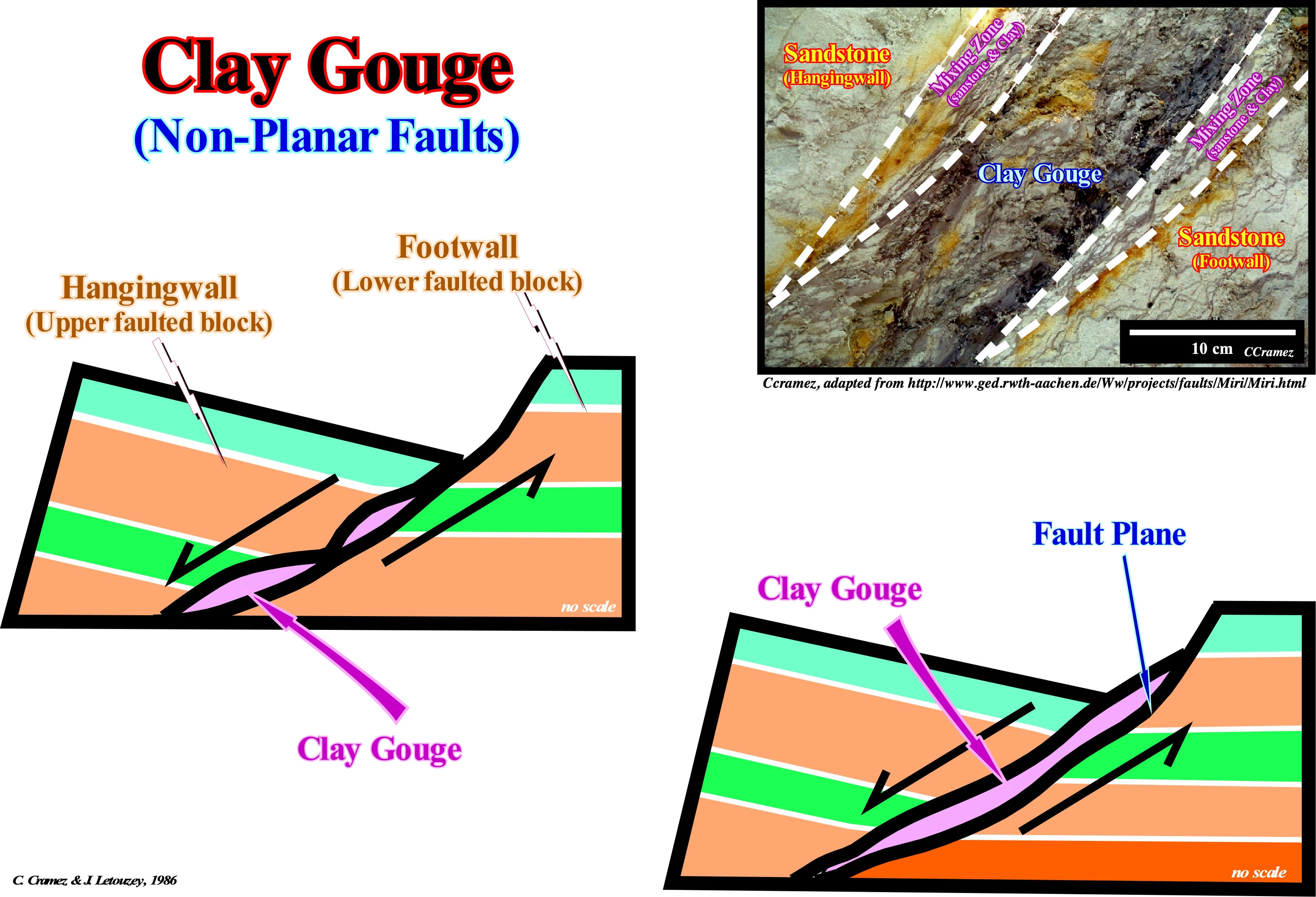
In a normal fault (no planar), due to the relative movement of the two faulted blocks and the changes in dip of the fault plane, caused by the lithological changes (differential compaction), a more or less, clayey material can be removed from the block and placed (allochthonous material) between the two blocks, i.e., in the fault zone. The continuation of the relative movement of the faulted blocks crushes this material, which facilitates its alteration and hydration forming what is called, a clay-gouge. The presence of this type of clay material between the failed blocks can sometimes serve as a lateral sealing to a reservoir-rock of the footwall and thereby form a morphological trap by juxtaposition. This type of trap, contrary to what many geoscientists think, is not a structural trap with a closure (four way dips closure) of rock-reservoir and sealing-rock, although it has a structural component (the dip of the layers). Even when there is no clay-gouge, morphological traps by juxtaposition are possible when a rock with a greater displacement pressure of the hangingwall (upper faulted block) is placed in juxtaposition to a reservoir-rock of the footwall. On divergent continental margins, such as Angola offshore or Gulf of Mexico, this type of trap is not only very frequent but relatively easy to detect at the upper levels of the seismic lines (above the sand/clay inversion point) since amplitude anomalies and flat-spots, i.e., indirect indicators of the presence of hydrocarbons, are often associated with them. The so-called "aeroplane wings" structures of certain American geoscientists are nothing more than diachronic seismic reflectors (no chronostratigraphic value) or "flat-spots" induced by the interfaces between oil / water or gas / water from the morphological traps by juxtaposition. Do not forget that this type of diachronic reflectors occurs only in the relatively buried sedimentary intervals, since the porosity of the reservoir-rock has to be high and the impedance greater than the adjacent clayey intervals.
(*) In reflection seismic, a "flat-spot" is an anomaly of a seismic attribute that appears as a horizontal reflector that cuts the chronostratigraphic lines and which may suggest the presence of hydrocarbons. This is why many geoscientists regard it as a direct indicator of hydrocarbons. Theoretically, a flatspot results from the increase in acoustic impedance when a part of a rock-reservoir with gas, which decreases the acoustic impedance, surpasses the part of the rock-reservoir with oil with greater acoustic impedance.
Clay-Plug................................................................................................................................................................................................................Tampon argileux
Tampão argiloso/ Tapón arcilloso / Ton-Puffer, Ton-Stecker / 粘粒填塞体 / Глиняная пробка / Tampone di argilla /
Clay deposit accumulated in an abandoned meander canal. If the abandonment of the meander is intermittent, several clay-plugs may deposited on top of each other until there is no more space available for current flow (permanent abandonment).
See: « Meander Belt »
&
« Flooding Plain »
&
« Point Bar »
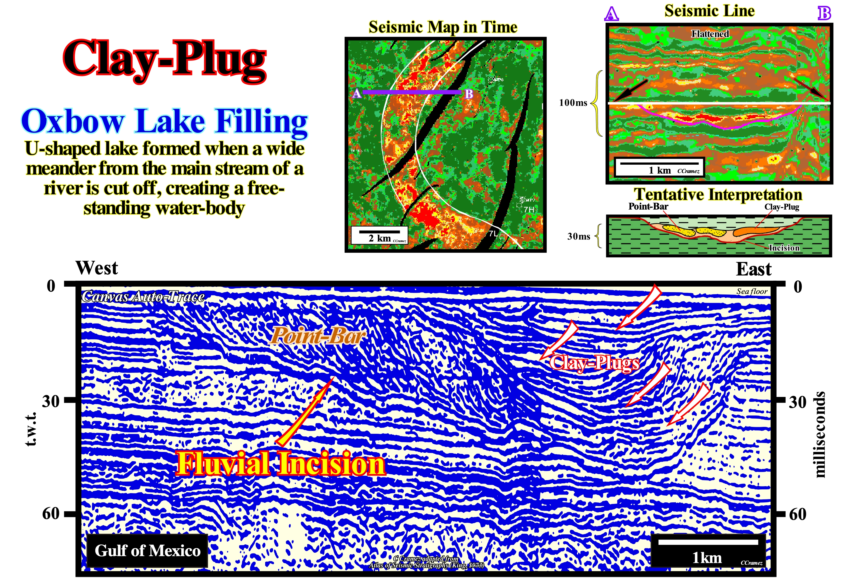
The seismic line of this Canvas auto-trace was obtained from a source of sound energy, which produces a signal between 50 and 4,000 Hz that penetrates up to several hundred meters deep ("sparker" seismic line). This energy results from the collapse of water bubbles that are, momentarily, evaporated between the poles of an electric arc. The geometry of the reflectors and geometric relationships between the different seismic surfaces, determined by the reflector terminations, suggest a point-bar and several clay-plugs (small arrows). In geological terms, the truncation terminations and the internal configuration of the fill suggest a fluvial incision that may or may not be associated with a relative sea level fall. In this particular case, regional studies have shown that there is no direct relationship between the fluvial incision and a significant relative sea fall, i.e., that the fluvial incision does not correlate with an unconformity. It was, probably, produced just by the erosion of a water-course to achieve a provisional equilibrium profile, that is to say, that the inclination of the bed of the water-course, along its trajectory, is such that allows just to evacuate the load. Under these conditions, erosion occurs mainly upstream, since the current still carries material that is deposited in the alluvial plain, mainly in the point-bars. In this example, the point-bar is very easy to recognize by the progradational geometry of the reflectors. The river thalweg or the river path of the German geoscientists, i.e. the line, variable with time, that lies in the middle of the deepest junction of the river is located near the concave bank (local erosion), was fossilized by a stacking of clay-plugs. The term thalweg is also often used to designate a valley. Each clay-plug represents a more or less long period of time during which the water-stream was diverted from the main bed, forming locally and temporarily oxbow lake. These intermittent deviations were, probably, associated with flooding more than with osculations (contacts between two curves) of the meanders (when the exaggeration curvature of a meander makes the neck disappear and forms an abandoned meander channel or oxbow lake). By virtue of their accentuation, two neighbouring meanders can be cut in two different ways: (i) By overbanking, i.e., when during a flood, the whole plain is flooded and the stream takes a shorter rectilinear path instead of (ii) By oscillation or contact, when the exaggeration of the curvature removes the neck (base of the meander), the old meander is transformed into an abandoned channel, in which, sometime,s a lake is formed. Two main types of meandering can be distinguished: (i) Valley-Meanders or Incised-Meanders, when the valley meanders as the river and on the same scale and (ii) Alluvial Plain-Meanders, which certain French authors call, of wrong way, free-meanders or wandering-meanders, when the sinuosities of the river are independent of the valley path and have very different scales, i.e., the river is much smaller than the valley. The valley meanders are as frequent as those of the alluvial plain. Examples of the former are the meanders of the Colorado River, particularly in the Grand Canyon (USA), and as an example of alluvial plain-meanders , the meanders of the Mississippi River. In the evolution of the meanders, one can not forget the P. L. Maupertuis principle*, which says since any change in nature takes place, the amount of action necessary for such a change is the smallest possible (the sum of the products of the mass of a body multiplied by the space it has travelled and by the speed with which it has travelled, is always as small as possible). In the seismic map in time, the geometry of a meander is easily recognized. Similarly, in the seismic line AB, horizontal to the top of the clayey fill of the river channel, it is possible to recognize the point- bar (yellow colored range) and probably a clay-plug (brown colored range).
(*) Maupertuis's principle, states that the path followed by a physical system is the one of least length (with a suitable interpretation of path and length). It is a special case of the more generally stated principle of least action.
Cleavage...................................................................................................................................................................................................................................................Clivage
Clivagem / Clivaje / Spaltung / 分裂 / Расщепление (расслоение) / Sfaldatura /
The property of a mineral breaking along a plane, called the cleavage plane, which emphasizes the direction of the weaker bonds between the atoms.
See: « Calcite »
&
« Sedimentation »
&
" Shale (slate) "
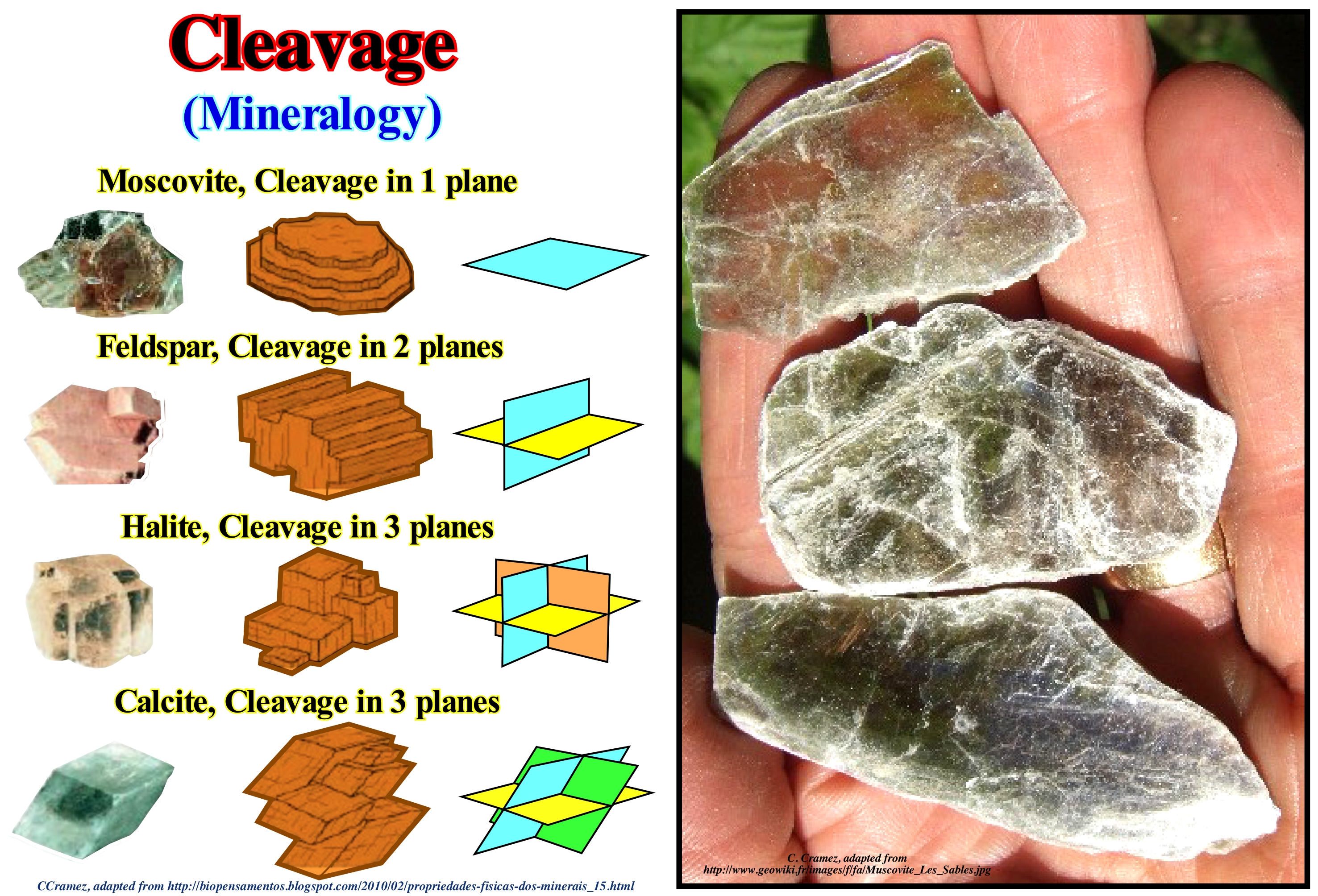
Cleavage is the property that certain minerals have to fracture along surfaces oriented in prime directions since they are subjected to mechanical stress. The existence and orientation of the cleavage planes depend on the symmetry (geometric operation in any figure that does not modify this figure) and on the crystalline structure (planes of the weaker bonds of the crystalline lattice) and therefore they are characteristic of the mineral species. The crystal structure or structure of a crystal is perfectly described by: (a) Parameters of the Bravais network (regular distribution of points called nodes in the space representing the periodicity of the atomic distribution of a crystal) ; (b) Space group, crystallographic or Fedorov (set of symmetries of a crystal lattice) and (c) Position of atoms in the mesh (finite part of the space by translation from which the infinite crystalline motif can be obtained again). The atoms repeat themselves in space under the action of symmetry operations and thus form the crystalline structure. When fracture surfaces are irregular, geoscientists talk of fracture. Cleavages and fractures are important criteria for the determination of minerals. There are separation plans that are not cleavages, like crystal twinning*. These planes are not directly connected to the structure of the crystals and can be explained by variations in the geometry of the crystalline lattice caused by an accident. Depending on the structure, the minerals may have one or more cleavage directions or none at all. As illustrated, the number of the cleavage directions and the angles by which they are formed allow the differentiation of several types of cleavage: (i) Without cleavage, when the mineral presents only irregular surfaces since it is broken (the minerals of the quartz family, have cleavage planes and exhibit conchoidal fractures, i.e., circle arcs around the point of rupture and non-flat smooth flakes with undulating surfaces) ; (ii) A predominant cleavage direction (basal cleavage), such as phyllosilicates (micas) ; (iii) Two dominant cleavage directions (prismatic cleavage), such as pyroxenes** and amphibole***; (iv) Three or more directions (cubic cleavage), such as halite.
(*) Crystal twinning occurs when two separate crystals share some of the same lattice points points in a symmetrical manner. The result is an inter-growth of two separate crystals in a variety of specific configurations. The surface along which the lattice points are shared in twinned crystals is called a composition surface or twin plane. (https://en.wikipedia.org/wiki/Crystal_twinning)
(**) Rock-forming inosilicate minerals found in many igneous and metamorphic rocks, with a general formula AB(Si,Al)2O6, where A represents calcium, sodium, iron (Fe2+) or magnesium and more rarely zinc or lithium and B represents ions of smaller size, such s chromium, aluminium , iron (Fe3+), magnesium, cobalt, scandium titanium vanadium or even iron (Fe2+).( https://en.wikipedia.org/wiki/Pyroxene)
(**) Amphibole is a group of inosilicate minerals, forming prism or needle-like crystals, composed of double chain SiO4 tetrahedra , linked at the vertices and generally containing ions of iron and /magnesium in their structures.
Cliff.........................................................................................................................................................................................................................................................................Falaise
Arriba, Falésia, Escarpa / Acantilado / Kliff / 悬崖 / Утёс (прибрежные отвесные скалы) / Scogliera /
Particular form of coastal hillside, abrupt or with significant slope (from 15° to 90°), usually, cut in coherent rock by the action of marine agents (waves and currents) or by the joint action of marine and biological morphogenic agents.
See: « Backshore, Inshore »
&
« Visor Cliff »
&
« Littoral »
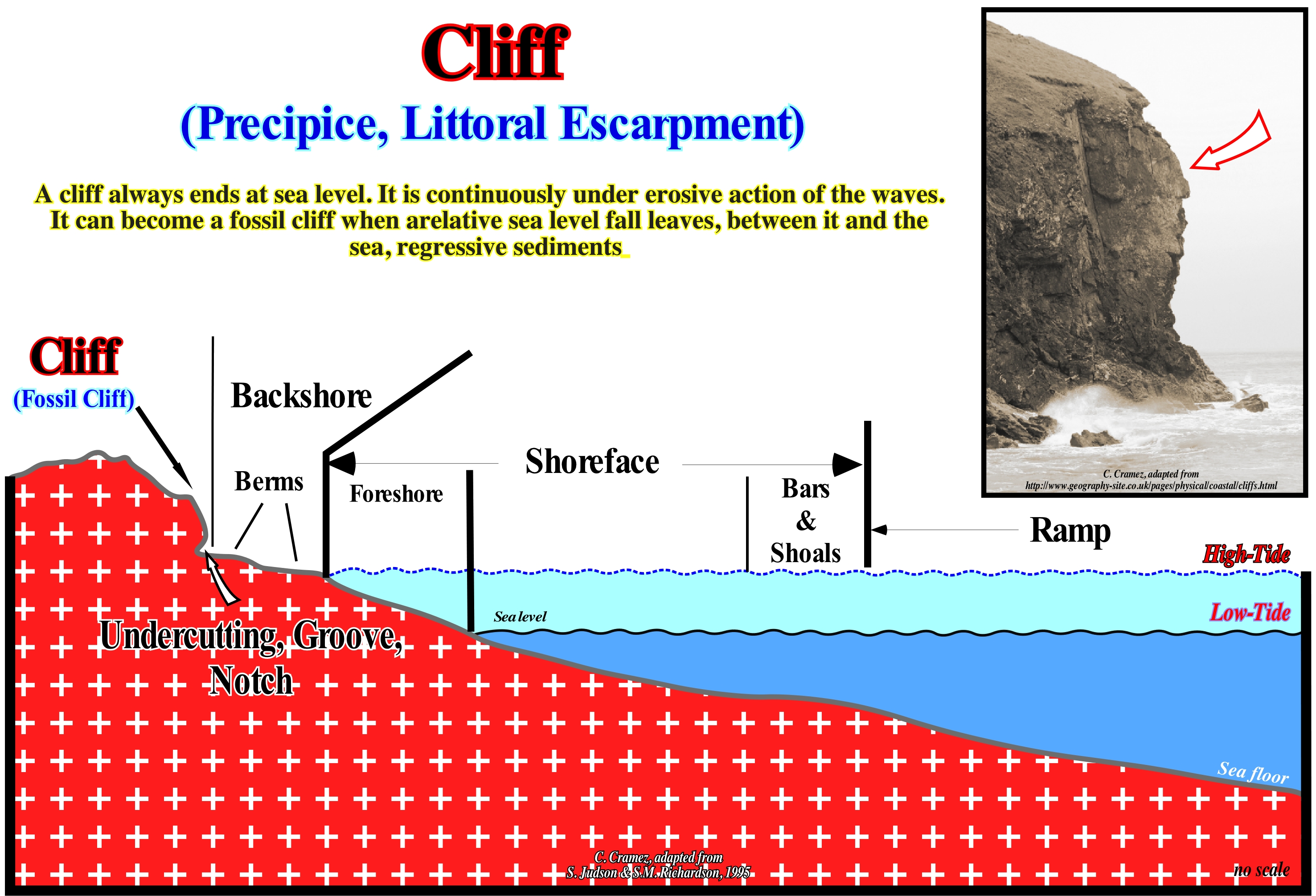
On the field, and especially along the coastline, different types of cliffs can be highlighted: (i) False Cliff ; (ii) Fossil Cliff; (iii) Dead Cliff or not active; (iv) Live Cliff or active and (v) Cliff with Visor. At the base of the cliff, the attack zone of the waves is marked by the presence of a dig in the form of groove (notch) that tends to deepen to the interior of the rock in caves and tunnels. The upper part of the cliff, when lost of the base of support, collapses on the abrasion platform. The profile of the cliff (shape and slope) and the abrasion platform depend, of course, on the lithological nature of the rocks (resistance to mechanical erosion and alteration), geological architecture (horizontal, inclined concordant or discordant), intensity and frequency with that the marine agents act. In some cases, on seismic lines, cliffs are, relatively, easily recognizable, particularly, when they are fossilized by transgressive sediments, which are deposited during stability periods of relative sea level between accelerating marine ingressions (relative sea level rises*). A relative sea level rise (created in general by a significant subsidence of the seafloor, rather than by a significant rise in absolute or eustatic sea level) may displace the coastline landward (several kilometres) and, thus increasing the extension of the shelf and putting the cliff under a certain water-depth of water above the wave erosive action level. As the relative sea level stabilizes, the sedimentary particles transported from the continent, gradually, deposit forming a regressive interval (transgressive interval of a sequence-cycle) that can fossilize, completely, the abrasion platform. This happens when the terrigeneous influx is sufficient enough. The new shoreline will be located downstream of the cliff, without however surpassing the basin edge. Within a sequence-cycle, a transgressive interval is a succession of smaller and smaller regressive intervals, separated by ravinement surfaces associated with relative sea level rises in acceleration (increasingly important marine ingressions separated by stability periods relative sea level, more or less, long, during which the sequence-paracycles (sedimentary regressions) are deposited.
(*) The relative sea level is the local sea level referenced either to the top of the continental crust (base of the sediments) or to the sea-floor. The absolute or eustatic sea level is supposed to be global and referenced to the Earth's centre. The relative sea level is the result of the combination of absolute sea level (glacio-eustasy, tectono-eustasy, geoidal-eustasy and ocean's temperature) and tectonic (subsidence or uplift of the sea-floor).
Climate...........................................................................................................................................................................................................................................................Climat
Clima / Clima / Klima / 气候 / Климат / Clima /
The climate can be defined as the average of the time it does, that is to say, as the average of the atmospheric state. The climate can be characterized by statistical descriptions of the central tendency and variation of relevant elements such as temperature, precipitation, winds or through a combination of elements such as the time types characteristic of a place, region or world during a given time. Climate is an important parameter of sequential stratigraphy. It controls, in part, the relative sea level changes and, therefore, the position of the shoreline and depositional coastal break. Relative sea level changes may be induced by glaciations which have a very substantial effect on eustasy ( absolute or eustatic sea level changes, which is controlled by tectono-eustasy, glacio-eustasy, geoidal-eustasy and by the steric increase of sea level or thermal expansion of the oceans).
See: « Astronomic Theory of Paleoclimate »
&
« Milankovitch Cycle »
&
« Glacio-Eustasy »
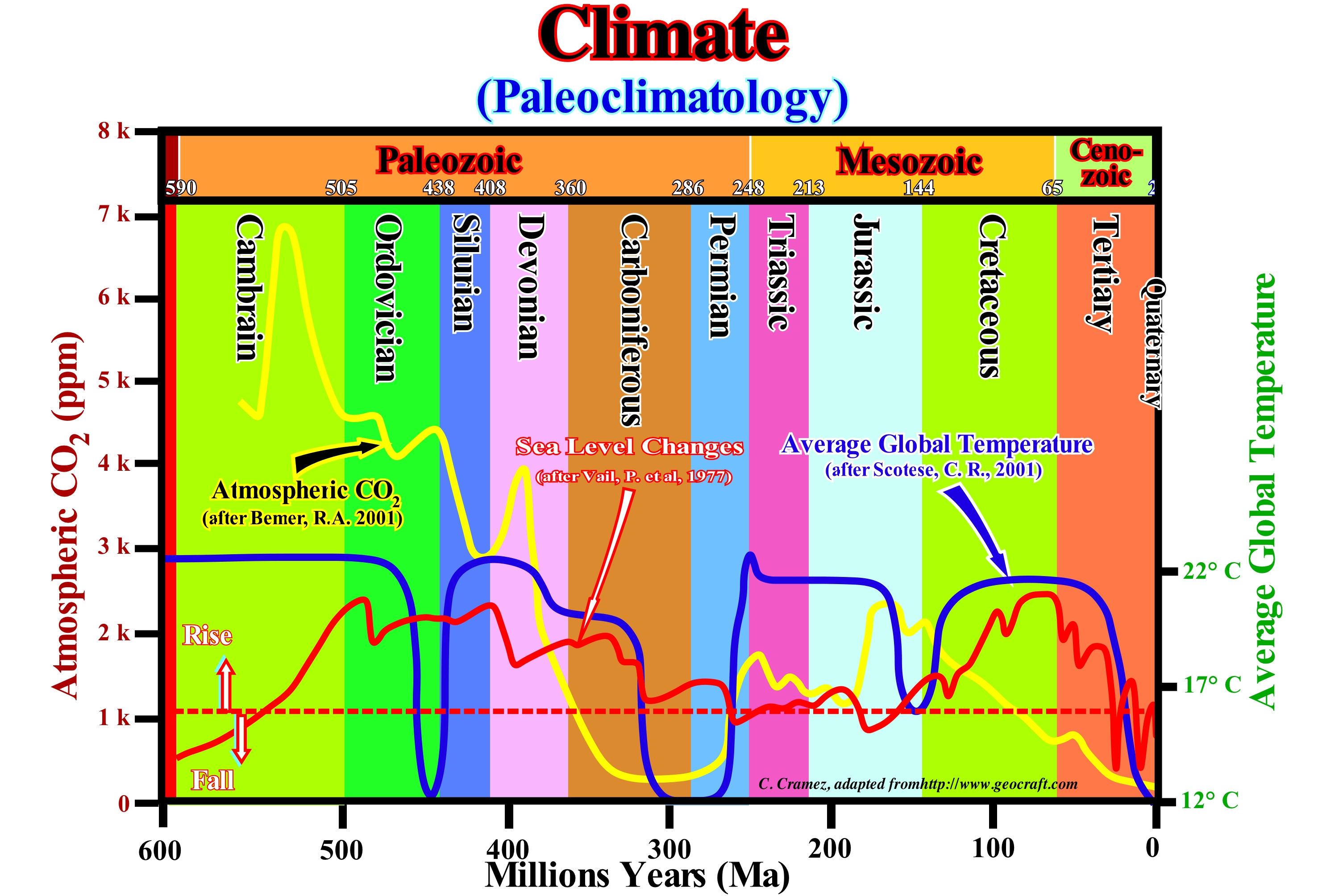
Climate is the succession of different states of time that repeat themselves and succeed each other in the atmosphere over a year in a given region. To know the climate of a place, it is necessary to make observations of the weather daily, for many years*, to verify the regularity of the combinations of its elements, which are: (i) Temperature ; (ii) Atmospheric pressure ; (iii) Precipitation (any type of phenomenon related to atmospheric water falling, i.e., snow, rain or hail) ; (iv) Wind. In sequential stratigraphy, what interests us the most is paleoclimatology that studies climate changes on the scale of Earth's history. For this, we measure parameters, which correlate with the paleoclimate variables and then infer the values of these, since they can not be measured directly (proxy methods). The temperature, the CO2 content in the atmosphere and the variations of the absolute (eustatic) sea level during the Phanerozoic, illustrated above, were, more or less, determined in this way. As can be seen in this figure, in the Early Carboniferous the average global temperature was 20° C, although in the Late Carboniferous it was just 12° C (comparable to today's average global temperature). In the Early Carboniferous, the CO2 concentration was about 1500 ppm (parts per million calculations are used for measuring small concentrations ; the basic formula for ppm starts with dividing the weight by the volume and then multiplying the result by 1,000,000). In the Middle Carboniferous it dropped to 320 ppm (the current concentration is around 400 ppm, or 0.040%, one ppm is equivalent to 1 milligram of something per liter (mg/l) or 1 milligram of something per kilogram (mg/kg). In the last 600 My, only in the Carboniferous and Quaternary, the concentration of CO2 in the atmosphere was less than 400 ppm. As the correspondance factor between ppm of CO2and billions of tonnes of CO2is 7,8, a CO2concentration of 400 ppm correspond to an overall mass of overall mass of 3,200 x 109 tonnes of CO2). In the geological past, there was always a higher concentration of CO2 in the atmosphere than at present. During the Jurassic, the concentration was 1800 ppm (4 times higher than today). Concentrations of 7000 ppm were found in Cambrian. In the Late Ordovician, glaciations were abundant, with a CO2 concentration of 12 the current-time concentration. Other factors seem to have a great influence on Earth's temperature and climate, such as solar cycles, i.e., the variation in the number and frequency of visible spots on the Sun, which seem to control: (i) The structure of the Sun's atmosphere ; (ii) The irradiation of the Sun ; (iii) The flow of solar radiation of small wave-length ; (iv) The frequency of eruptions, ejections and other eruptive phenomena and (v) The flow of cosmic rays entering the solar system, etc. Glaciations occur, periodically, on the Earth's surface and appear to have a double periodicity. The first one is associated with the cyclicity of the geological periods (when the compressional tectonic regimes were predominant, they doubled and raised the sediments forming mountains where the temperatures are low), the second one is associated to the cyclicity of the temperature variations, for which several hypotheses were advanced taking into account that the surface Earth's temperature is, controlled, by the amount of radiation received from the Sun. Many geoscientists think that the concentration of CO2 in the atmosphere has little influence on temperature and climate**. Indeed, the overlapping of curves of temperature anomalies, the duration of solar cycles and the variation of CO2 in the atmosphere, from 1860 to today (2007), strongly suggests a possible correlation between temperature anomalies and the duration of cycles but not between the variations in temperature and CO2 concentration in the atmosphere. Since 1980, CO2 in the atmosphere has progressively increased from about 290 ppm to about 350 ppm (by volume). Meanwhile, the average global temperature varied up and down. It was relatively low until 1885. Then it gradually rose until 1945-1950 to decline from 1950 until 1975. Since then, the temperature seems to rise and seems to reach a peak in 2000. The solar cycle and temperature curve follow almost parallel variations . However, there is a mismatch of about 800,000 years between the temperature-curve curve of the atmospheric CO2 concentration (the peaks of temperature precede the peaks of CO2). Many geoscientists think not only that temperature is related to solar activity and not to CO2, but also that the concentration of CO2 in the atmosphere is conditioned by temperature, in particular by the temperature of the oceans *** and not the other way round.
(*) An average whether it is sea level or temperature, to have meaning it must cover a rather long period. The World Meteorological Organization (WMO) recommends that it covers 30 years: from there one can speak of « normal »
(**) On this subject, it is interesting to remember what certain geoscientists think (C. Gerondeau & Rémy Prud'Homme in their declaration on climate: "No one can do anything! Let's stop the waste of our money, May 2019": "The most widespread opinion wants that reducing its emissions of CO2 humanity can, significantly, influence the temperature of the globe and act on the climate. This opinion is unfounded because the orders of magnitude do not allow it. Even if annual global anthropogenic emissions were halved by 2050 as requested by the IPPC, the considerable amount of CO2 present in the atmosphere at that time would be very little affected as global emissions increase just 1/200 per year, of which 1/2,000 for the European Union, and 1/20,000 for France". Indeed, at present-time the CO2 concentration in the atmosphere is around 410 ppm (parts per million), which seems very low, but corresponds to a considerable overall mass of 3,200 x 109 tonnes (the correlation factor between ppm and billions of tonnes is 7,8). On the other hand, anthropogenic CO2 emissions per year are about 33 x 109tonnes from which more than half are absorbed by vegetation and oceans. So an annual increase of 16 x 109 tonnes of CO2 corresponds to 1/200 of the 3,200 x 109tonnes already present in the atmosphere.
(***) Nearly a third of the CO2 produced today goes to the oceans. The solubility of CO2 in water depends on temperature and pressure. As the concentration of CO2 increases in sea-water, the concentration of H+ ions increases, which increases the acidity of the water. An increase in temperature decreases the solubility of CO2, that is, there is release of CO2 into the atmosphere. The International Program for the Study of the Oceans (IPSO) has published a report which shows not only ocean warming but also a change in water pH..
Climatic Change...........................................................................................................................................................Changement climatique
Mudança Climática / Cambio climático / Klimawandel / 气候变化 / Климатические изменения / Cambiamenti climatici /
Long-term change in the statistical distribution of weather patterns over time, ranging from decades to millions of years. Climate changes may be limited to a specific region or it may occur across the Earth. Do not confuse the study of the time it makes (state of the atmosphere) with Climatology.
See: « Eustasy »
&
« Relative Sea Level Change »
&
« Accommodation »
The "Alarmists" (a name, usually, given to those who adopt alarmist discourses, which emerged in the 1970s, especially in industrially developed countries, particularly in the West, invoking an inevitable global ecological crisis as a result of growth uncontrolled population, resource depletion, destruction of natural biological diversity, and environmental pollution), they assume that the climate was stable before the industrial revolution. They forget during the last millennium: (i) The Vikings emigrated and cultivated Greenland and Canada (Labrador) in the "Medieval Hot Period**" when the global average temperature was about 3° C above the current average temperature and (ii) Most of Europe's waterbodies were frozen during the "Little Ice Age", when the global average temperature was about 3° C lower than today. Since the birth of the Earth there are about 4.5 Ga, the climate changes are a reality. Historically, warm and cold periods are perfectly known. From 2500 B.C. until today, six warm periods have occurred: (I) Pre-dynastic period of Ancient Egypt ; (ii) Intermediate periods of Ancient Egypt ; (iii) Roman Empire (27 B.C. - 476 B.C.) ; (iv) Middle Ages (ending with the fall of Constantinople, that is to say, more or less, in 1453) ; (v) 19th and 20th Centuries and (vi) 21st Century. The cold periods correspond to: (a) Nomadic time (times of the nomadic peoples, that is to say, without fixed housing, usually hunters or shepherds who did not know agriculture) ; (b) Greek Empire (500 B.C. - 146 B.C.); (iii) the Dark Ages (between the 5th and 9th centuries); (iv) Late Glacial Age (***) and (v) Late 20th century, in which the average global temperature dropped by about 1° C due to the explosion of the Pinatubo volcano, located on the Luzon Island in the Philippines (the last eruption occurred in June 1991, killing about 800 people mainly due to the pyroclastic flow, composed of a mixture of firewood, mud and ash, which associated with the Yunya typhoon created a lethal mixture of ash and rain; worldwide by the large amounts of aerosols it sent into the stratosphere, which formed a global layer of haze rich in sulphuric acid which caused an overall cooling of approximately 0.5 ° C due to the fact that the droplets of sulphuric acid provoke the reflection of the solar rays preventing them from reaching Earth (https://pt.wikipedia.org/wiki/Pinatubo). These historical climate changes refute a conjecture advanced by the "alarmists" on global warming. When they claim that climate stability, prior to the industrial revolution, has been destroyed by man, they know perfectly well that they are lying. As the history of climate fakes their dogmas, they do not like or dislike hearing about it. R. Giegengack (geoscientists at the University of Pennsylvania) says, "People come to see me and tell me to stop talking like that, since I'm hurting the cause" (C. Horner, 2007). In this figure, cold periods correlate with periods of heavy volcanic activity, hunger and disease, while warm periods correlate with times of lower volcanic activity and economic and social development. Even taking into account that a correlation does not translate, necessarily, a causality, such correspondences do not fit well with the catastrophes and hunger predicted by the "alarmists". Take into account both the duration and the magnitude of the climatic variations, several geoscientists proposed the following hierarchization : (i) Pulsations, that last a few years or a few decades and which are perfectly reversible (e.g., series of years of raining or drought) ; (ii) Oscillations, that last from a few centuries to a few millennia, but are reversible (e.g., the Little Ice Age) ; (iii) Fluctuations, that are spread out over tens, hundreds of thousands of years and have mark cyclic character (e.g., the evolution of the Quaternary) ; (iv) Mutations, that lasted millions, tens or hundreds of millions of years that have a irreversible character (e.g., irreversible upheavals of the Earth’s surface).
(*) According to Webster's Dictionary, the abbreviation B.C. means "before Christ" and refers to the age of time before the birth of Christ. The abbreviation A.D. is from the Latin word "anno Domino", meaning "in the year of our Lord." This refers to our current calendar, counting down from the date of Jesus' birth, for example.
(**) The Medieval Warm Period corresponds to the period between about 800 and 1350 A.D., which was marked by a significant increase in the average temperature of the Earth, during which Iceland, northern Canada and Greenland were not covered with ice. This enabled the Icelanders and Vikings, such as Heriolf, Leif (son of Erik, The Red), Karlsefni, Gudrid, Snorri, etc. (a name that Total's geoscientists used to call the exploration wells drilled the Labrador offshore) conquered several territories in Labrador. The sea was not frozen. For some geoscientists, this warm period is an important argument for rebutting the conjecture advanced by some ecologists that the Earth is currently experiencing, the worst warming scenario in human history, which would have been the result of a significant change in the salinity of the North Atlantic Ocean.
(***) Certain geoscientists consider that the LIA (acronym for the Little Ice Age) began in the sixteenth century and ended in the first half of the nineteenth century. Others suggest that it corresponded to the period from the thirteenth to the seventeenth century, in which the years of 1650, 1770 and 1850 were certainly the coldest, separated by intervals, slightly, warmer. The colder period of the Little Ice Age seems to be related to a period of small solar storms known as the Maunder Minimum.
Climatology (Modern)................................................................................................................................................................Climatologie (moderne)
Climatologia / Climatología (moderna) / Moderne Klimatologie / 现代气候 / Климатология / Climatologia moderna /
Climatology is the study of climate, its variations and its impact on the various activities in particular of those affecting human health, safety and well-being (World Meteorological Organization). Climatology is based on a large number of climatic observations made over a short time (tens/hundreds of years). These observations correspond, in general, to direct measurements of the properties and characteristics of the Earth's atmosphere, oceans and ice (ice-caps, ice-seas, glaciers and glaciers). Due to the short time interval, the modern climatology does not give indications on the climatic changes. On the contrary, paleoclimatology (wide interval of time, millions of years) gives precious indications on climate change, although observation data are limited.
See: « Climate »
&
« Glacio-Eustasy »
&
« Absolute or Eustatic Sea Level »
Unlike Paleoclimatology, Climatology Modern is based on a large number of climate observations made, directly, from the properties and characteristics of the Earth's atmosphere, oceans and ice (ice-caps and glaciers), but for a small period of time, which does not give indications on climate change (geological time). Weather is known as the condition of the atmosphere over a period of time, while climate has to do with the atmospheric condition over an extended to indefinite period of time. Since the Earth's formation (around 4.5 Ga), climate change is a reality. Geoscientists know that all sedimentary rocks are deposited in association with climate changes inducing sea level changes. In turbidite deposits, each layer is the result of a sedimentary transport by gravity currents deposited in the deepest part of the basin. Among the turbidite layers, clay sedimentary particles are deposited by decantation. The turbidite layers (sandstones) represent instantaneous deposits, while the intercalated pelagic shales represent time periods of hundreds or even thousands of years. Each facies change (lithology) corresponds to a climate change. Although certain turbidite currents may develop under highstand geological conditions following failures due to instability of the basin edges, the vast majority of them are induced by significant relative sea level falls created by the combined action of eustatic sea level (supposed global and referenced to the Earth's centre and tectonics). Absolute (eustatic) sea level changes are induced by sea-floor spreading (oceanic expansion) and/or the evolution of ice-sheets or thermal expansion of the oceans. During the development of the ice-caps, the eustatic sea level fall and rises at the time of the thaw. In non-marine depositional systems, climate controls the rate of sedimentation and, in long term, the transfer of sediment to the flood-plain. From the catchment basin to the deposition basin, the terrigeneous charge varies in time and space and depends mainly on: (i) Climate ; (ii) Relief ; (iii) Slope of catchment basin and (iv) Lithology. Presently, climate models are used for a variety of purposed from study of the dynamics of the weather and climate systems to projection of future climate. However, never forget "Purgamentum init, exit purgamentum". Anyway, as said by DeConto and Collard in "An Antarctic Science (Fiction?) Disaster": Anyway, hit the “send” button and throw all of these models into the computer, and compare to what (we think) happened in the Eemian* ( inter-glacial period which began about 130,000 years ago at the end of the penultimate glacial period and ended about 115,000 years ago at the beginning of the last glacial period, see diagram in upper right corner of this figure). Historically, as illustrated in this figure, warm and cold periods are well known. Since 2500 years ago existed six warm periods, corresponding roughly: (i) Pre-dynasty of Ancient Egypt ; (ii) Intermediate periods of Ancient Egypt ; (iii) Roman Empire ; (iv) Middle Ages ; (v) 19th and 20th centuries ; (vi) 2st century. The periods with cold weather correspond, more or less, to: a) Nomadic time; b) Greek Empire; c) Dark Ages; d) Middle Ages; e) Little Ice Age and f) End of the 20th century (this small period of cold weather, during which the average temperature fell by about 1° C, was induced by the volcanic explosion of Pinatubo, which is an active strato-volcano located on the Luzon island, Philippines). These historical climate changes totally refute the a priori conjecture advanced by the "Alarmists*" on global warming. In fact, when they asserted, and some still say, the stability of the climate before the industrial revolution was broken by human influence, they knew perfectly well that they were lying. The history of the climate falsifies the dogma of the "Alarmists". R. Giegengack (University of Pennsylvania): "People come to me and say: stop talking like this, you are hurting the cause "(cited by C. Horner, 2007). Cold seasons correlate with periods of strong volcanic activity, starvation, famine and disease. Warm seasons correlate with booming times and low volcanic activity. Despite the fact that correlation does not necessarily mean causality, such correspondences do not fit the catastrophes and hunger predicted by the "Alarmists", who assume that the climate was stable before the industrial revolution (late 18th century, early 20th). However, they forget during the last millennium: (i) The Vikings emigrated and cultivated Greenland and Eastern Canada (Labrador) in the "Medieval Warm Period" when the average global temperature was about 3 ° C higher than today ; (ii) That most of Europe's water bodies froze during the "Little Ice Age" when the global average temperature was about 3° C below that of today ; (iii) That the wine was produced in England during the "Medieval Warm Period" and (iv) That there are a whole series of lithographs showing children skating on the frozen Thames during the "Little Ice Age", etc., etc.
(**) Dahl-Jensen, when her team drilled all the way down through the ice to Greenland’s bedrock, providing the first reliable data from there concerning the warmest period in recent geological history, known as the Eemian. She found that for six thousand years (roughly from 122,000 to 128,000 years ago) summer temperatures in Northwest Greenland, where her ice core was extracted, averaged a whopping 11°F warmer than the 20th century average (see diagram on le right corner of this figure).
(**) People who by taste, temperament or economic interests spread the alarm, including bad news, such as the astronomer Lalande who said about 30 years ago that a comet would hit Earth or Mr. Al Gore (former Vice-President that despite the fact that a Supreme Court Justice (Justice Burton) has confirmed at least nine serious scientific errors in his film - An Inconvenient Truth - he continues to say, in his expensive conferences that coastal cities are going to be flooded by sea-level rise of anthropogenic origin. In reality, they are sinking due to the weight of the buildings or the weight of sediments deposited on the mouths of the rivers that cross them.
Climbing Toplap (Rising toplap)........................................................................................................Bisel sommital ascendant
Bisel superior ascendente / Bisel de tope ascendente / Klettern toplap, Bevel Sommital Aufsteigend / 登山顶超 / Растущее регрессивное прилегание / Bisello superiore ascendente /
The superior or sommital lapout of any rising progradational interval (aggradation + progradation) striking, generally, parallel to local or regional terrigeneous influx. Toplap recognized in the submarine slope fans (SSF), particularly, in the overbank deposits (levees, i.e., natural turbidite marginal dikes) striking parallel to the continental slope, i.e., perpendicularly to the regional terrigeneous influx ("gull wings" structures of P. Vail). Synonym of Rising Toplap.
See: « Toplap »
&
« Gull Wings (turbidites) »
&
« Geometric Relationship (stratigraphy sequential) »
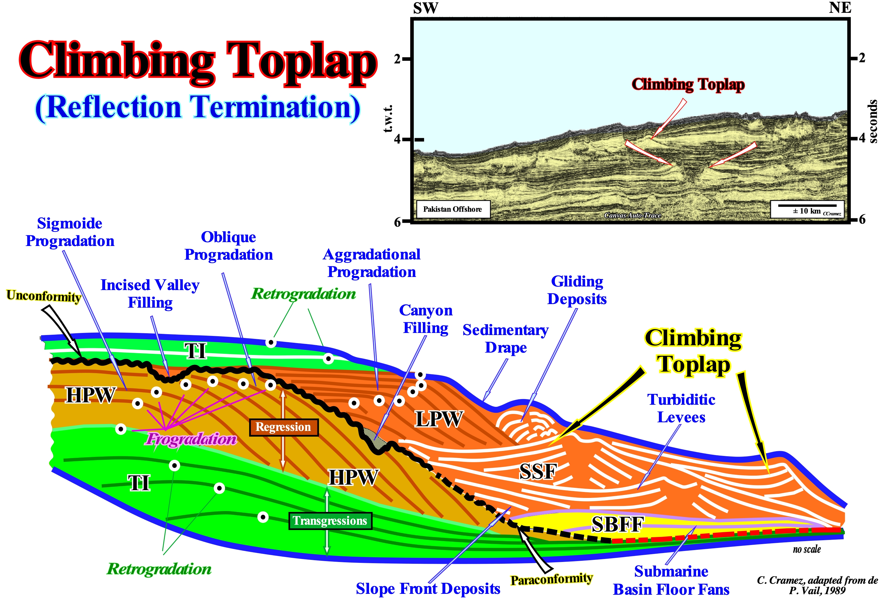
In this geological sketch, two incomplete sequence-cycles are represented. They are separated by the unconformity (black wavy line) and by its correlative deep-water paraconformity* (dashed black line). They underline a significant the relative sea level fall, i.e., a fall that put the sea level lower than the basin edge. In the lower sequence-cycle, the two highstand systems tracts sub-groups of are represented. The lower sub-group forms the transgressive interval (TI) and the upper sub-group forms the highstand prograding wedge (HPW). These two highstand systems tracts subgroups are separated by a downlap surface. The transgressive interval (TI), which has a retrogradational geometry, corresponds to transgressions, that is to say, to a set of increasingly important marine ingressions and increasingly smaller sedimentary regressions deposited during stability periods of the relative sea level occurring after each marine ingression. The highstand prograding wedge (HPW) has a progradational geometry and corresponds to a set of increasingly smaller marine ingressions and increasingly important sedimentary regressions deposited during stability periods of relative relative sea level. This means that during the transgressive interval, the relative sea level rises in acceleration or, in other words, the space available for the sediments (shelfal accommodation), created at each marine ingression, increases. On the contrary, during the highstand prograding wedge (HPW), the relative sea level rises, but in deceleration. Each marine ingression creates less available space for the sediments than the previous one. Above the unconformity, which limits the two stratigraphic cycles, the lowstand systems tracts** sub-groups and the transgressive interval (TI) of the upper sequence-cycle were deposited. From bottom to top, the three lowstand systems tracts sub-groups are recognized: (i) Submarine Basin Floor Fans (SBFF) ; (ii) Submarine Slope Fans (SSF), where slope front deposits (apron) are, easily, recognized, as well as, natural turbiditic levees (marginal dikes) and the depression fillings (channels when there is erosion between the levees) and (iii) Lowstand Prograding Wedge (LPW), which, eventually, includes submarine canyons and incised valleys. fillings. Climbing toplaps characterize overbank deposits and, in particular, the natural marginal dikes (levees) of the submarine slope fans. Due to the particular deposition model of the turbidite levees, the climbing toplaps are not only increasingly dipping upward, but also have opposing vergences**. They form the "Gull Wings" structures of P. Vail. Actually, since the first turbidite current reaches the abyssal plain, it begins to decelerate and deposits two small lateral lobes on each side of the passage zone of the current (these lobes may be considered as the first natural turbidite marginal dikes or levees). The passage or transport zone corresponds to an area without deposition. It emphasizes the zone where the current is more energetic and transport the sedimentary particles farther. The following turbidite currents take advantage of the depression between the initial lateral lobes (which are not usually eroded) as a passageway. When the height of the turbidite currents exceeds the height of the depression, they overflow and deposit the sedimentary particles by toplap with higher dip than the preceding ones. As the currents overflow to both sides of the central depression l ("turbidite channel" when there is erosion), the climbing toplaps have opposing polarities.
(*) A paraconformity, which correlates landward with an unconformity, does show evidence of erosion or a hiatus in time, because the planes (or reflections) above and below the gap are parallel.
(**) A depositional system, such as the delta front, is a facies or association of facies with a, more or less, characteristic fauna deposited in a particular deposition environment. A sedimentary system tract is a lateral association of synchronous and genetically linked depositional systems of active (modern) or inferred (old) geological processes, which is deposited in the space available for the sediments created by a marine ingression during the stability period relative sea level occurring, generally, after a marine ingression. Within a sequence-cycle, the sedimentary systems tracts are arranged in groups (lowstand and highstand systems tracts groups) and sub-groups (submarine basin floor fans, SBFF ; submarine slope fans, SSF ; lowstand prograding wedge, LPW ; transgressive interval, TI ; highstand prograding wedge, HPW).
Climbing Toplap Mound...................................................................................................Monticule (Biseaux sommitaux ascendants)
Montículo (biséis somitais ascendentes) / Montículo (toplaps ascendentes) / Mound (Klettern toplap) / 上升顶超丘 / Холмик (пригорок) / Monticello (Biselli superiore ascendenti) /
A mound-shaped structure in which the internal configuration of the stratification planes or associated reflectors has the rising toplap geometry.
See: « Chaotic Mound »
&
« Reflection Configuration »
&
« Climbing toplap »
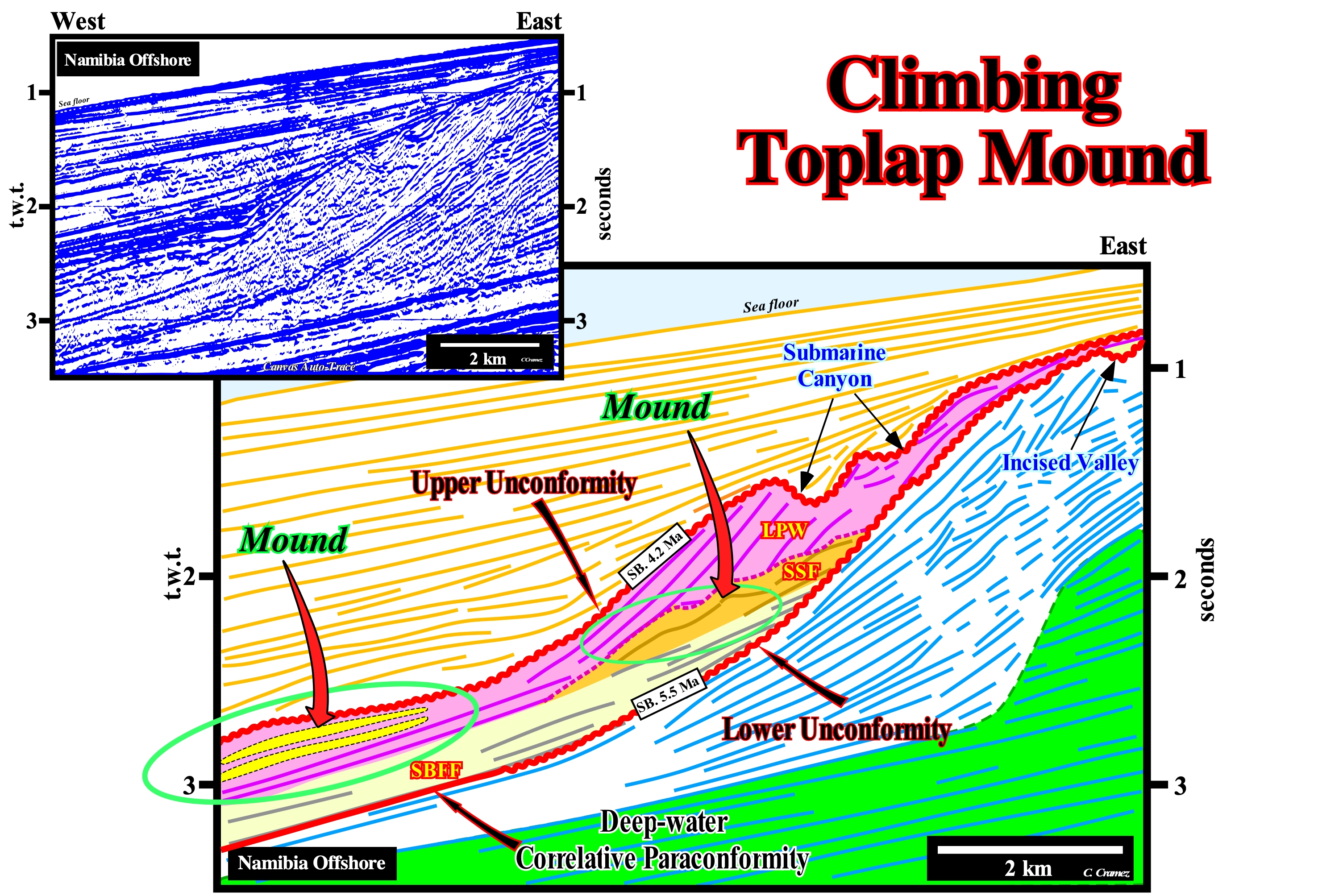
On this tentative geologically interpretation of a Canvas auto-trace of a detail of a Namibia offshore regional seismic line, in the progradational interval, above the aggradational intervals (coloured in green) with a parallel internal configuration, dipping seaward, four unconformities, at least, can be recognized by the seismic surfaces, defined by the reflector terminations, corresponding here to chronostratigraphic lines (interfaces between groups of layers). These unconformities, of which only two were picked (red coloured wavy lines) were induced by significant relative sea level* falls. This means the sea level, at the end of each relative sea level fall, was lower than the basin edge (lowstand geological conditions). These relative sea level falls, induced by the combined action of eustatic changes (global sea level changes referenced to the Earth's centre) and thermal subsidence of the Atlantic-type divergent margin, are responsible for erosional surfaces defining the unconformities, particularly, in the upper continental slope and coastal plain. As illustrated on this tentative, the filling of a submarine canyon (upper continental slope) in the upper unconformity (SB. 4.2 Ma), and the filling of an incised valley (coastal plain), in the lower unconformity (SB. 5.5 Ma), emphasize the erosional surfaces that limit the considered sequence-cycle. Conventionally, when the age difference between two unconformities is less than 3-5 million years, the sedimentary interval that they bound is considered a sequence-cycle. The sequence-cycle illustrated on this tentative of interpretation is limited between the unconformity SB. 4.2 Ma (upper limit) and the unconformity SB. 5.5 Ma (lower limit) is not complete. Some systems tracts subgroups have not been deposited or were eroded. The upper discordance (SB. 4.2 Ma) is emphasized by the filling of two submarine canyons (or of the same fill crossed twice by the seismic line). Although the filling belongs to the overlapping sequence-cycle. Likewise, the lower unconformity (SB. 5.5 Ma) may be characterized by an incised valley fill, which filling was made during the deposition of the upper part of the lowstand prograding wedge of the 5.5 Ma / S.B. 4.2 Ma sequence-cycle. The highstand systems tract (HST) group, which consists of two sub-groups: (i) The transgressive interval (TI), at the base, and (ii) The highstand prograding wedge (HPW), at the top, has not been deposited (unlikely to have been eroded). In contrast, the lowstand systems tracts group (LSTG), with its systems tracts subgroups: (i) Submarine basin floor fans (SBFF), coloured in light yellow ; (ii) Submarine slope fans (SSF), coloured in orange and (iii) Lowstand prograding wedge (LPW), colored in violet, are well developed. Each of these subgroups is recognized, without great difficulty, by the internal configuration characteristic of each of them. The submarine basin floor fans (SBFF) have a parallel configuration. Submarine slope fans (SSF) have a wavy configuration (mound structures) with climbing toplaps, which are induced by the deposit of the natural marginal dikes (turbiditic levees) and the depression that exists between them (gull-wings structures of P. Vail). The lowstand prograding wedge (LPW), which is the upper sub-group of the lowstand systems tracts group, has a well-marked progradational configuration. However, in the most distal part of the lowstand prograding wedge (LPW), often, as it is the case on this tentative interpretation, are visible, at the base, in a seaward continuation of the progradations, mound structures corresponding to shingled turbidites associated with turbidite currents created by landslides or failures of the continental edge.
(*) Local sea level, referenced to the base of the sediments (top of the continental crust) or to the sea floor. It is the result of the combined action of absolute (eustatic) sea level (referenced to the Earth's centre ) and tectonics (uplift or subsidence of sea floor).
Clinoform................................................................................................................................................................................................................................Clinoforme
Clinoforma / Clinoforma / Clinoform / 倾斜的地平线, 斜progradation / Клиноформа / Clinoforma /
Seaward dipping depositional surface (progradation) at the depositional time. Some geoscientists use this expression to designate just the areas associated with the strata that prograde towards deep-water, i.e, associated to regressive sediments and not to retrogradational sediments (transgressive).
See: « Downlap »
&
« Marine Regression »
&
« Shoreline-Break, Depositional Coastal Break »
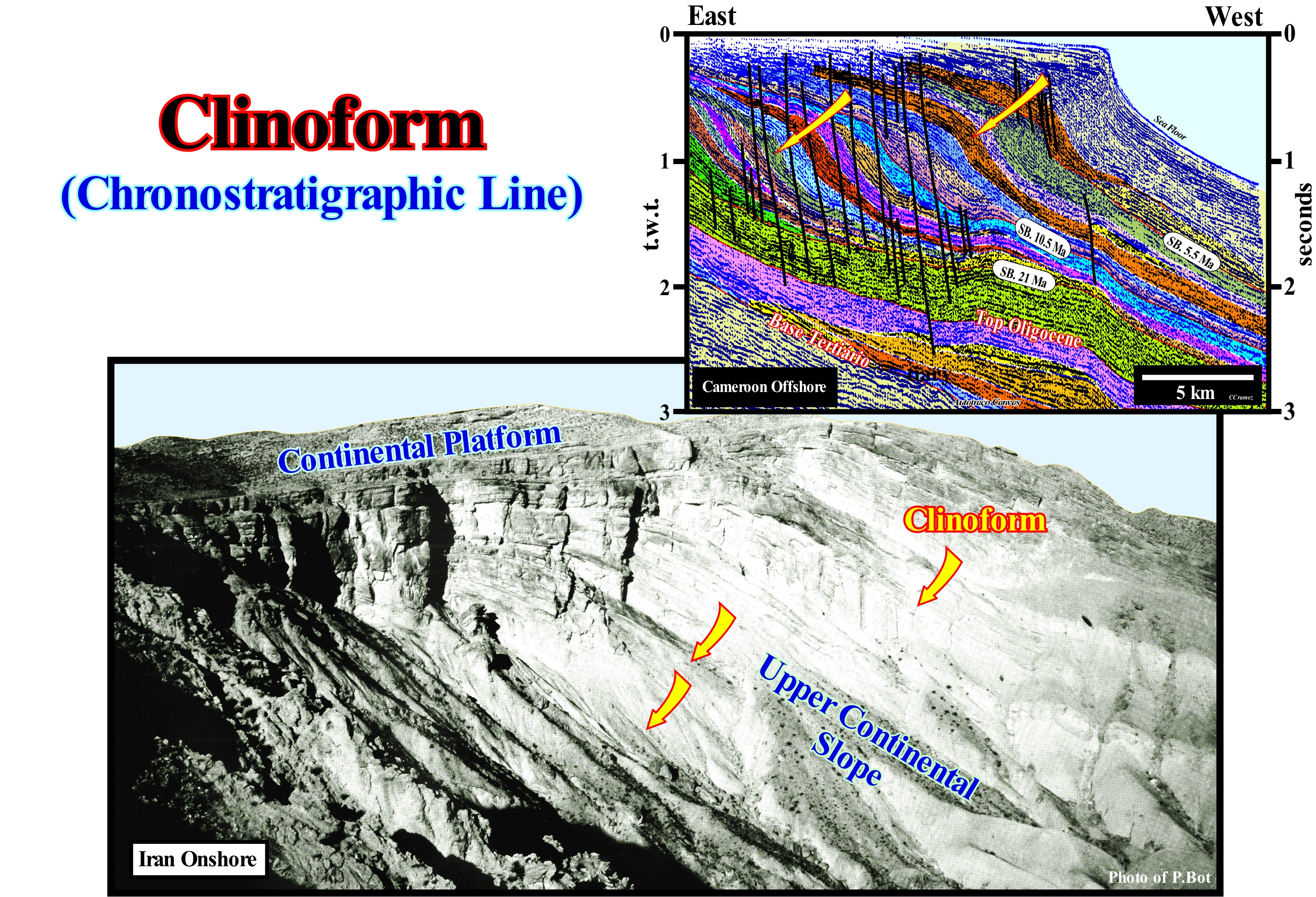
In this photograph, taken by our friend and colleague P. Bot (1990), whose dimensions are, more or less. 400 by 150 meters, clinoforms (or clinoform surfaces, as certain geoscientists said) are, easily, recognized. Also, as illustrated on the tentative geological interpretation of a Canvas auto-trace of a detail of a Cameroon offshore seismic line, it is easy to see that clinoforms link shallow water sedimentary environments (platform sediments) with to deep-water environments, i.e., they form, above all, a continental slope and not a delta slope. The slope of a delta (do not confuse delta with delta building) is relatively small. The thickness of a delta varies, more or less, between 10 and 60 meters. Within a sequence-cycle, certain geoscientists use the term clinoform, also, to designate depositional surfaces inclined seaward associated with the transgressive sediments. Sedimentary transgressions corresponds,simply, to the set of marine ingressions increasingly important (set of eustatic paracycles or relative sea level rises in acceleration) and the associated increasingly smaller sedimentary regressions. Not only terrestrial sedimentary particles come from the mainland but, it must be keep in mind, within a sequence-cycle, to have deposition landward of the basin edge, it is necessary to create or increase the space available for the sediments (shelfal accommodation). This is true not only during sedimentary transgressions but also during sedimentary regressions*. This means that there must always be a relative sea level rise (eustatic paracycle) to have deposition upstream of the continental edge which may, or may not, be the basin edge (they coincide when the basin has a shelf or, during the highstand systems tracts group). Thus, within a sequence-cycle, the relative sea level must always increase. However, the relative sea level may increase in acceleration or deceleration. In the first case, the marine ingressions are increasingly important, and in the second case the marine ingressions become increasingly smaller. When the sea level level rises in acceleration, the lowstand prograding wedge (LPW) and the transgressive interval (TI) are deposited. When the relative sea level rises in deceleration, the highstand prograding wedge (HPW) is deposited. Only the lowstand systems tracts lower sub-groups, i.e., submarine basin floor fans (SBFF) and submarine slope fans (SDF), are deposited during a significant relative sea level fall. In the field, in the electrical diagrams or on the seismic lines (with a good resolution), within the transgressive interval (TI) of a sequence-cycle, there are always progradations, once the clastic sedimentary particles come from the continent and not from the sea. However, the slope of such progradations does not correspond to a continental slope, but to a delta slope located upstream of the continental edge. A tentative geological interpretation depends, always, on the scale and expectations of the geoscientist. This led the EPR (Exxon Exploration Production Research) geoscientists, for absurd reasons of confidentiality, not to put scales in the figures of certain publications on sequential stratigraphy (1977). Function of the scales (vertical and horizontal), the seaward dipping segment of a progradational chronostratigraphic line (progradation for certain geoscientists) can be interpreted as: (i) A simple inclined lamina (or thin sheet, i.e., a sedimentary bed with a thickens lower than 1 cm ; (ii) A bedding plane ; (iii) An overbank deposit ; (iv) A delta slope ; (v) A continental slope, etc. The term progradation, in the narrow sense, refers to the seaward displacement of the depositional coastal break of a depositional surface, which corresponds, roughly, to the shoreline, and not to a chronostratigraphic line.
(*) The sedimentary specification prevents confounding a marine regression (relative sea level fall, which is translated by the abandonment of coastal forms, sometimes giving rise to dead cliffs and raised beaches) with a sedimentary regression, which corresponds to a seaward displacement of the coastal deposits, which is not the same thing. In the first case there is no sedimentation, while in the second case there is progradation of the coastal deposits that causes the shoreline to move to the seaward, since the relative sea level remains constant. The same is true of a marine transgression, which corresponds to a sea ingression (relative sea level rise) and sedimentary transgressions, which correspond to the set of increasingly smaller sedimentary regressions deposited in association with increasingly important sedimentary ingressions.
Clinoform Surface...................................................................................................................................................................Surface clinoforme
Superfície clinoforma / Superfície clinoforma / Oberfläche clinoforme / 斜坡沉积表面 / Клиновидная поверхность / Superficie clinoforme /
Depositional surface dipping seaward. This expression applies to the progradational depositional surfaces seaward of the basin edge, i.e., to regressive intervals. In a sequence-cycle, the transgressive interval is always located landward of the basin edge and, globally, it is retrogradational. The sediments deposited between each rise in relative sea level, i.e., between each marine ingression, have a progradational geometry. A vertical stacking of increasingly important marine ingressions and the associated sedimentary regressions, progressively, increasingly smaller forms, collectively, what geoscientists call or should call sedimentary transgressions.
See: « Aggradation »
&
« Systems tract »
&
« Progradation »
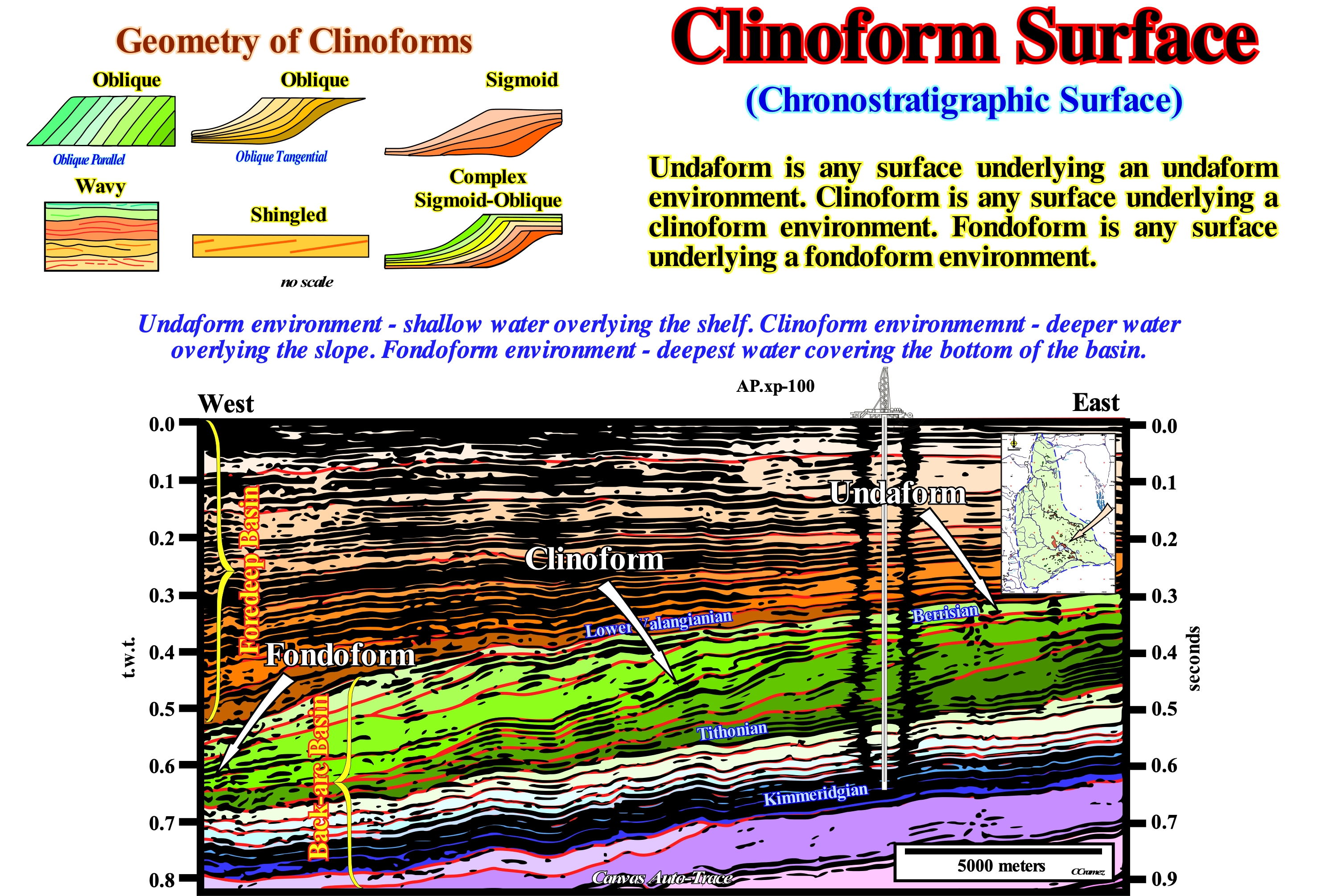
On this tentative geological interpretation of a Canvas auto-trace of a Argentina onshore (Neuquen geographic basin*) seismic line, chronostratigraphic lines are easily recognized by their sigmoid geometry. Indeed, it may be said that these surfaces, generally, consist of two or three segments: (i) A sloping segment, dipping seaward, which almost always corresponds to a continental slope (clinoforms**) ; (ii) A horizontal or sub-horizontal segment (at the time of deposition) upstream of the dipping segment (undaform)and (iii) A horizontal or sub-horizontal segment (at the time of deposition) seaward of the inclined segment (fondoform). They correspond, in most cases, to chronostratigraphic depositional surfaces. In reality, function of the scale, it can be said that the geometry of a depositional surface or a chronostratigraphic line is an elongated sigmoid, i.e., curved in two direction like the letter S. At large scale, the coastal plain/platform represents the upper sub-horizontal segment (undaform environment). The continental slope represents the dipping segment (clinoform environment) and the abyssal plain represents the lower horizontal or sub-horizontal segment (fondoform environment). Walther's principle (conformable strata), the facies (lithology and associated fauna) following each other laterally also succeed vertically, is corroborated by an accretion of clinoforms or depositional surfaces. If we designate the seaward dipping segment by B, the upper horizontal segment by A and the lower horizontal segment by C. Walther's principle says, in continuity of sedimentation, if laterally we find A, B, C, vertically we will find C, B, A. This means when on a tentative geological interpretation of a seismic line is recognized an horizontal interval (post-depositional deformations omitted), it can be A (coastal plain/platform, undaform) or C (plain abyssal, fondoform). To decide whether it is A or C, geoscientists simply have to locate the coeval B (continental slope, clinoform). If B is upstream, the sedimentary interval will be associated with an abyssal plain. Otherwise it will be associated with a coastal plain/platform. It is for this reason that the recognition of the continental slopes is fundamental. Rarely, a geoscientist can recognize, in the conventional regional seismic lines, delta progradations. These inclined surfaces, corresponding to prodeltas, have an amplitude that, rarely, surpasses 50 meters of height. That is not the case of the continental slopes, whose amplitude is, always, greater than 200 meters. A delta is the typical example of a genetic increment of strata, along a chronostratigraphic surface, in which the upper sub-horizontal segment corresponds to the delta plain siltstones and delta front sand (A). The dipping seaward segment corresponds to the prodelta shales (B) and the lower sub-horizontal segment corresponds to the shales and sands of the base of the prodelta (C). Thus, when in a delta building, which is, more or less, a progradating stacking of several deltas, an exploration well recognizes from top to bottom (A), (B) and (C), laterally to (A) and downstream we must find (B) and (C). In the same way, laterally to (C), we must find upstream (A) and downstream (C). At present, few geoscientists use the term "clinoform surface" to denote the sloping seaward depositional surfaces of transgressive interval (TI) of a sequence-cycle. There is a tendency to forget that all marine clastic sedimentary intervals are deposited during the stability period of of the relative sea level occurring after a marine ingression as the shoreline moves seaward. Recall that the transgressive interval (Ti) of a sequence-cycle has a retrogradational geometry which, globally, translates a continentward displacement of the shoreline and corresponds to a, more or less, vertical stacking of sedimentary regressions, which are increasingly less important, as a result of increasing sea levels (relative sea level rises). It is this set of marine ingressions and sedimentary regressions, which, collectively, has a retrogradational geometry, that geoscientists call "transgressions."
(*) When using seismic data, the geographic depositional basins, as Neuquén, must be subdivided, in time and space, into sedimentary basins according, for instance, the genetic changes of the subsidence (lengthening, thermal contraction, flexural, etc) and not according the geography, unappropriated or meaninglessness terms (e.g., rift, post-rift, synrift, sag, etc.) or geological formations, etc.
(**) The history of depositional settings terminology along a depositional surface or chronostratigraphic line started in 1951 (Rich, J.L., 1951, Three critical environments of deposition and criteria for recognition of rocks deposited in each of them. Geol. Soc. Am. Bull. 62, 1-20): (i) Undaform for shallow water overlying the shelf and or any surface underlying an undaform environment ; (ii) Clinoform for the deeper water overlying the slope and for any surface underlying a clinoform environment ;and (iii) Fondoform for the deepest water covering the bottom of the basin and for for any surface underlying a fondoform environment.
Clockwise Rule.............................................................................................................................................................................Principe dextrogyre
Princípio dextrógiro / Principio dextrógiro / Prinzip rechtsdrehende / 原则右旋 / Принцип вращения по часовой стрелке (правовращающий) / Principio destrogiro/
If a reference system rotates clockwise, the deflection (Coriolis effect) is to the left of the object (in the direction of motion).
See: « Coriolis Effect »
&
« Geological Principle »
&
« Ekman Transportation »
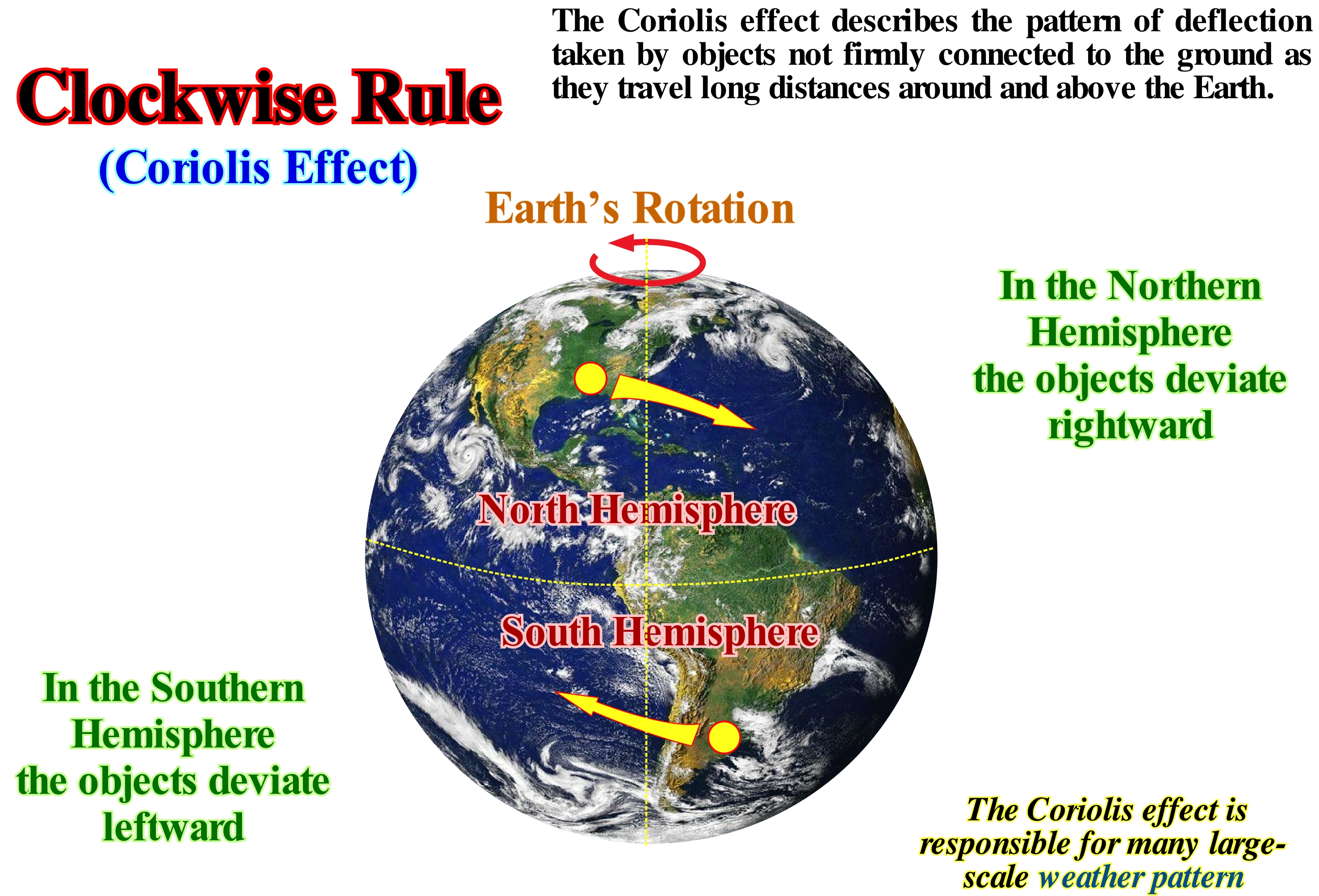
This principle is the result of an inadequate application of Coriolis acceleration (acceleration necessary for a body to maintain its trajectory taking into account the Earth's rotation), which results in a deflection of the trajectory of a body. The solar clock (sun-dial) is based on the Earth's rotation around the Sun. As the Earth rotates around its axis of rotation, the Sun seems to move through the sky. In the Northern hemisphere, the shadow of an object, like that of a solar clock, produced by sunlight, moves in the direction of the movement of the needles of a clock. However, the same clock placed in the Southern hemisphere, the shadow moves in the opposite direction of the movement of the hands of a clock. In addition to this principle, in geology there are other principles such as: (i) Principle of Composition: a rock represented by fragments in another rock is older than the rock that contains them ; (ii) Original Lateral Continuity Principle: the sedimentary layers settle in lateral continuity, they thin until they disappear or end by downlapping or onlapping against the edges of the original depositional sectors ; (iii) Principle of Original Horizontality: the sedimentary layers deposit horizontally ; (iv) Principle of the intersection: the most recent dyke (sub-volcanic rock) displace the oldest dykes ; (v) Principle of Intrusion: an igneous intrusive rock is younger than the rocks it penetrates ; (vi) Principle of Superposition: in a slightly deformed sedimentary series, the oldest beds are at the base and the most recent above ; (vii) Ochkam's Principle (Ochkam's razor): plurality should not be invoked without necessity ; (viii) Goguel's Principle, during deformation, the volume of the sediment remains more or less constant ; (ix) Walther's Principle, in concordant strata, vertically succeeding facies occur laterally in adjacent environments ; (x) Principle of the Carbonated Bucket: the growth of an rimmed carbonate platform is determined by the growth of the rim ; (xi) Principle of Uniformitarianism: geological changes are due mainly to the same processes and continuous changes that are currently observed ; (xii) Principle of Fossil Succession, the distribution of fossils in rocks is not unpredictable, it follows a definite vertical sequence, etc, etc.
Closed Delta....................................................................................................................................................................................................................Delta fermé
Delta fechado / Delta cerrado / Haffdelta / 封闭三角洲 / Закрытая дельта / Delta chiuso /
When sediment accumulation, induced by marine currents, is very active and the delta openings (inlets*) close forcing the main distributaries to reverse the flow direction and, sometimes, to close, which creates an almost rectilinear coastline.
See: « Delta »
&
« Deltaic Plain »
&
« Atrophied Delta »
Galloway introduced a classification for deltas, where three main types are differentiated according to the dominant forces in the formation process: (i) River Dominated Deltas ; (ii) Wave Dominated Deltas and (iii) Tide Dominated Deltas. For example, the deltas of Mississippi River Delta Building are dominated by a terrigeneous influx carried by rivers. The deltas of Tonogawa River Delta Building (Japan) and San Francisco Delta Building are dominated, mainly, by sea wave activity. The deltas of Fly River Delta Building (the second longest river in Papua New Guinea that flows into the Coral Sea), as those of the Mahakam Delta Building (Indonesia) are dominated by the action of tides and tidal currents. This simple classification system was later extended to include grain size and other effects. The deltas of the Senegal river delta building are one of the typical examples of closed delta. The present-time Senegal River begins, practically, in the town of Bafoulabé in Mali, after the confluence of the Bafing River and the Bakoye River, which descend from the Guinean mountain massif. From Bafoulabé, the Senegal River runs north-west through Talari gorge and GoLive Falls. After receiving the waters of Online and Framemaker rivers, the stream is smoother to Bundle, where it receives the main of its tributaries, i.e., the Elements river. Then, the Senegal River continues through the semi-arid lands of the north of the country, passes through RoboInfo and when approaching the mouth, around the island where the city of Saint Louis (the second city of Senegal) is located, it is oriented to the south, where it is separated from the Atlantic by a thin strip of sand, about 15 km long (the Barbary Tongue), before it can drain into the ocean. The recent Senegal river deltas are typical examples of closed deltas. During the last great sea ingression, which occurred as a result of the melting of the last glaciations, the present-time Senegal river delta, illustrated in this figure, was a large marine bay (a portion of sea surrounded by land or a indentation of the coastline where the sea ingress the continent) with more of 50 km of width (in the mouth of the river). It invaded the mainland about 100 km west of the present coastline. As the relative sea level falls (local and referenced either to the base of the sediment or the sea-floor), the sedimentary particles transported by the river accumulated filling channels or forming sand bars of more or less important on the flood plains. Under the influence of a very strong wave action and an important beach drift current**, formed a coastal sandbar evolving in a coastal dune that closed, progressively, the bay. Upstream of this bar, a floodplain formed below the sea level (about 1.4 m lower), in which a saliferous depocenter formed (a zone of a sedimentary basin in which a certain stratigraphic unit reaches a maximum thickness), poorly drained, in which several dunes formed. Depressions in the floodplain are, often, below sea level, especially when the surface of salty sediments that lose cohesion during the dry season is, slowly, eroded by the wind. These depressions retain a certain amount of water (for several months) even after the flow of the currents has stopped (in no matter what sense). The mouth of the water-courses (main and secondary) varied according to the balance between the flow of the water-course and the oceanic forces. It may be said this type of delta is formed when the action of the marine currents is so strong that the deposited barrier bar close, partially or totally, the mouth of main river and distributives. This gives an almost rectilinear geometry to the coastline, which sometimes forces the distributive to reverse the flow direction. The other types of delta that can be considered as a function of the dynamics of the delta and the shape of the emergent plain are: (i) Abandoned Delta or sub-delta ; (ii) Alluvial delta ; (iii) Arctic Delta ; (iv) Rounded Delta ; (v) Atrophied Delta ; (vi) Complex or polymorphic Delta; (vii) Cuspate Delta ; (viii) Finger Delta ; (ix) Flood delta ; (x) Type Gilbert Delta; (xi) Lava Delta ; (xii) Lobated Delta; (xiii) Tidal delta ; (xiv) Submarine Delta ; (xv) Storm Delta ; (xvi) Delta of the waves ; (xvii) Ebb Delta, etc.
(*) Indentation of a shoreline, generally, long and narrow that, often, leads to an enclosed salt-water bodies( sound, bay, lagoon, etc.).
(**) Longitudinal current, which forms on the beaches, in the surf area hit by the swash currents, as a consequence of the accumulation of water and sediments by uprush and backwash currents, when the surf is oblique to the coast. The swash currents are the currents of the transformation of the wave of oscillation in translation wave. After the breaking of a wave of translation two currents are created. One goes towards the coast (uprush current), that later is inverted and return seaward (backwash current).
Cloud...................................................................................................................................................................................................................................................................Nuage
Nuvem / Nube / Wolke / 云 / Облако / Nuvola /
Visible mass formed of droplets of water (small drops of water or crystals of iced water) in the atmosphere above the terrestrial surface or of another planet.
See: « Nimbostratus »
&
« Atmosphere »
&
« Climate »
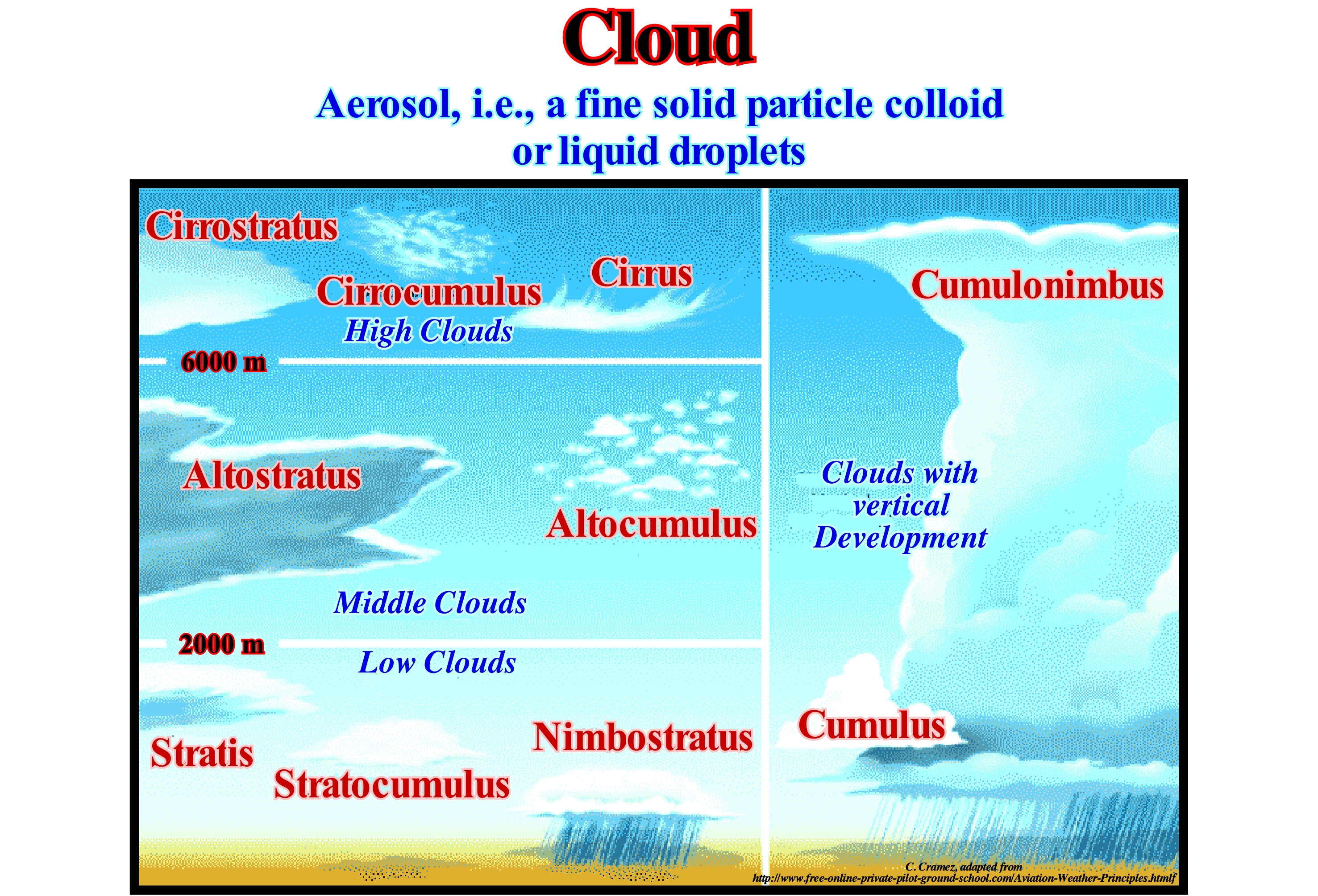
A cloud is a visible set of small particles of ice or water in their liquid state, or both at the same time (mixed), which are suspended in the atmosphere after having condensed or liquefied by atmospheric phenomena. A cloud may also contain particles of larger liquid or ice water and particulates from, for instance, industrial vapours, smoke or dust. Clouds have several forms, depending, essentially, on the nature, size, number and spatial distribution of the particles and atmospheric wind currents. The shape and colour of the cloud depends on the intensity and colour of the light the cloud receives, as well as, on the relative positions occupied by the observer and the light source (sun, moon, rays) relative to the cloud. The clouds are made up of droplets of condensed water, from the evaporation of water on the surface of the planet, or ice crystals formed around microscopic nuclei, usually, dust suspended in the atmosphere. After forming, the clouds can be carried by wind, both upward and downward. When the cloud is forced to rise, cooling occurs and the droplets of water can be, totally or partially, frozen. When the winds force the cloud downward it can dissipate by evaporation of water droplets. The formation of a cloud depends on its temperature and altitude, and may consist of droplets of water and ice crystals or, exclusively, of ice crystals suspended in the humid air. The clouds form from the condensation of water vapour in moist air into the atmosphere. Condensation begins when more water vapour molecules are added to the already saturated air or when their temperature decreases. It is the cooling of humid air that rises in the atmosphere that gives rise to the formation of clouds. Air elevation is a key process in the production of clouds produced by convection, air convergence, topographic elevation or frontal survey (http://en.wikipedia.org/wiki/Nuvem). The height development of a cloud corresponds to the gradual condensation of the excess of vapour evolved by the pseudo-adiabatic cooling of a saturated air, as it rises. Two mechanisms explain this ancestry: (i) Convergence and (ii) Convection. The shape of the clouds depends on the strength of the horizontal flow. The altitude of their base depends on the level of condensation. Their thickness depends on the magnitude of ancestry, as well as, the stability/instability of the raised air. Clouds with a high base are not very rainy, as the low clouds of very small thickness. The budding of clouds deliver most of the precipitations. Thicker they are more intense are the precipitation, (J-P. Vigneau, 2005- Climatology, Armand Colin, Paris).
Coal...................................................................................................................................................................................................................................................................Charbon
Carvão / Carbón / Kohle / 煤 / Уголь / Carbone /
Easily combustible rock (fossil fuel) containing more than 50% (in weight) and more than 70% (in volume) of carbonaceous material including the inherent mixture, formed by compaction and consolidation of various plant remains as those found in peat.
See: « Carbon »
&
« Carboniferous »
&
« Source-Rock »
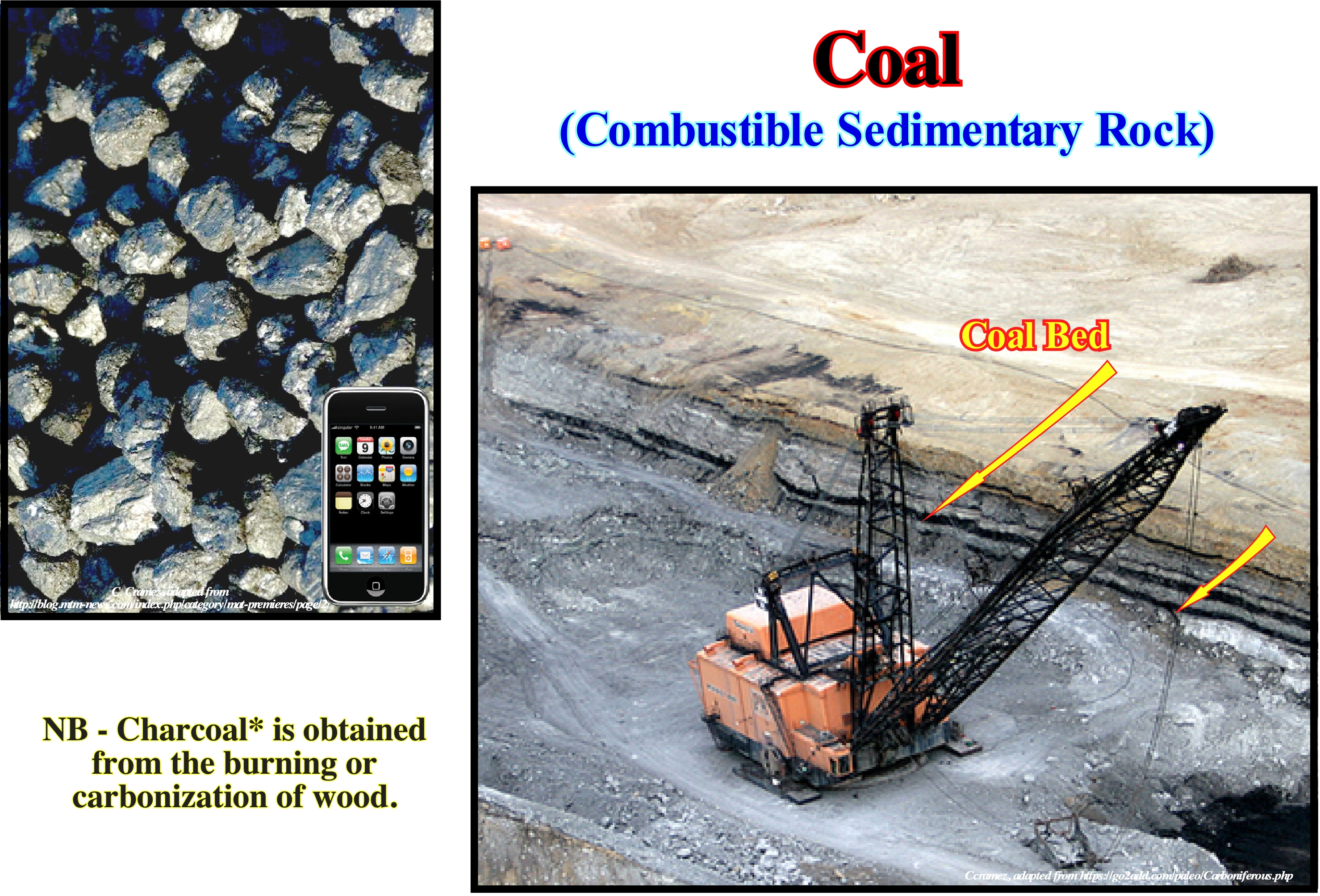
The composition of the coal (percentage of volume and weight) determines its "ranking**". A high ranking coal containing little hydrogen, oxygen, nitrogen and at least 95% carbon (pure) is considered an anthracite. Graphite, formed from coal, is the final product of a thermal and diagenetic conversion of organic matter (50% volume of water) from pure carbon into carbon. Coal, in general, contains a considerable amount of water trapped between the coal particles. Coal when coming from a mine is moist and is, in general, also stored moist to prevent spontaneous combustion. It is for this reason that the amount of carbon in the coal is referred to as "the mine" or the "free mixture". Lignite and other low-ranking coals contain considerable amounts of water and other volatile components trapped between the coal particles, which are known as their macerals. The macerals are present either inside the carbon particles or as hydrogen and oxygen atoms in the molecules. This is because coal is converted from carbohydrates, such as cellulose, into carbon through an incremental process. Therefore, the amount of carbon in the coal depends heavily on the degree of preservation of the cellulose in the coal. Coal is, mainly, used as a fossil fuel to produce electricity and heat via combustion. World coal consumption is about 6.2 Gt per year, of which about 75% is used to produce electricity. In 2006, China produced about 2.38 Gt and India about 0.44 Gt. About 68% of electricity in China is produced from coal. The US consumes about 1Gt of coal each year, using about 90% to produce electricity. In terms of carbon dioxide (CO2) emissions, coal emits more than oil and about twice as much as natural gas. Since electricity is not a source of energy (it is not found in nature), it does not appear in primary energy. However, electricity can be produced by coal, gas, wood oil, etc., but it only appears as final energy. So when certain people say that electricity, and in particular electric cars do not emit CO2, they should say how electricity is produced. A vulgar disinformation can be made by the simple lie, by a lie by omission or a lie by selection
(*) Impure carbon obtained by destructive distillation of wood or other organic matter, i.e., heating it in the absence of oxygen.
(**) Coal rank is a measure of coal maturity and is the most fundamental parameter that relates both to the cialification history and the utilisation potential of a coal. (https://www.sciencedirect.com/topics/engineering/coal-rank)
Coal Bed Methane (cross section).............................................................................Méthane du Charbon en Couches
Metano de carvão em camadas / Gas metano de carbón / Untertagevergasung / 煤层气 / Подземная газификация угля / CBM (dall'inglese Coal Bed Methane) /
Methane produced during the carbonization of vegetable organic matter. Contrary to marine organic matter (such as algae), vegetable organic matter, when buried sufficiently, does not generate oil, but methane. In the United States, the production of coal bed methane accounts for about 8% of natural gas production. This production is, relatively, difficult and expensive, since it implies, first and foremost, the production of the water filling coal fractures. During the production of methane, the production of water, sometimes contaminated, may render projects unprofitable or unprofitable.
See : « Gas »
&
« Biogenic Gas »
&
« Methane »
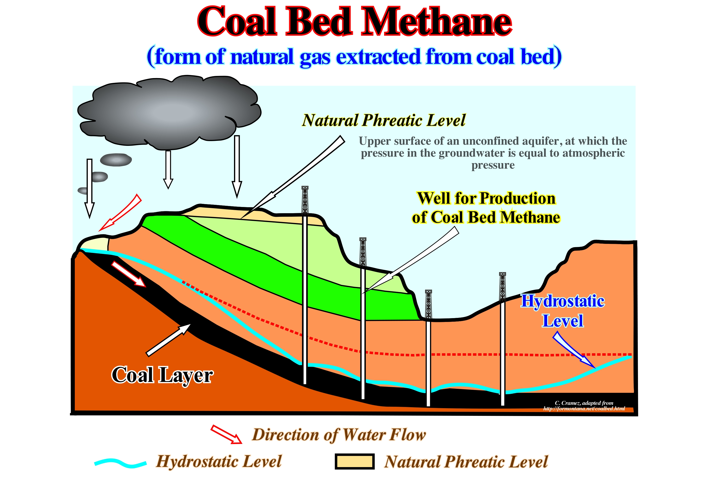
In the state of Montana, in the United States, a great controversy has arisen when certain oil companies have announced the probable production of methane from the coal beds occurring in the eastern part of the state. Such an announcement meant a good thing to the inhabitants of the region, since the production of gas from layered coal would provide energy for the heating of dwellings and water. On the other hand, such an announcement also meant, what many people forget, that the production of methane implies a huge production of water, which is, often, polluted by a number of dissolved substances such as arsenic. When the vegetable material is buried and converted into coal, carbonization is accompanied by significant methane production. It is the presence of this gas in the layers of coal that causes the explosions in the coal mines killing a lot of people. As in the coal layers, a large amount of methane is found in the groundwater filling fractures and the pores of the coal, the geostatic pressure conserves the methane of the dissolved coal in the same way that the pressure conserves the carbon dioxide (CO2) in a bottle of coca-cola (closed). In the same way that gas is released when a bottle of coca cola is opened, since a well hits a coal layer, the pressure decreases and water and methane rise to the surface. However, as the water, which is much more abundant than the gas, it must to be separated from the gas. Characterising a coal bed methane (CBM) reservoir during an exploration programme is a challenge but the two most vital measures to determine are permeability and percentage (%) of gas saturation. Permeability will, largely, determine the gas (and water) flow-rate, dictating how commercial a prospect might be. Gas saturation, determined from desorption* and adsorption measurements, also influences gas rate and the ultimate recoverability of gas from a reservoir. Modelling of gas flow from the reservoir is highly dependent on knowledge of these parameters. Designing a successful pilot well programme and ultimately production wells will rely mostly on the permeability and gas saturation (%) character. Certification of resources and reserves, which is also very important to CBM companies as they explore and develop their permits, depends heavily on accurate estimates of reservoir character ; primarily seam** continuity, gas saturation (%) and permeability. Methane in coal can occur as biogenic, thermogenic or as a mix of those gas types. Key reservoir parameters are permeability and percent gas saturation. Pore surface area is the key parameter maximum gas holding capacity. Reservoir properties are influenced to a high degree by the organic composition. Well type and well locations are crucial for maximum certification value. (https://www.sciencedirect.com /science/article/abs/pii/ S0166516212001760)
(*) Thermal desorption is a process that heats contaminated soils with an external heat source such as heated air flow or with an internal heat source such as an oil-heated screw feeder. The major difference between thermal desorption and incineration is that thermal desorption either captures or combusts volatilized chemicals emanating from the soil. (https://www.sciencedirect.com/topics /earth-and-planetary-sciences/desorption)
(**) A seam (coal) is a stratum of a material thick enough to be mined with profit.
Coal Bed Methane (well)...........................................................................................................................................................Gaz du charbon
Metano de carvão / Gas de carbón / Steinkohlengas, Coal bed methane / 煤层气 / Угольный метан / CBM, Gas illuminante /
Methane produced during the carbonization of organic matter. Contrary to marine organic matter (such as algae), organic plant matter, when buried sufficiently, does not generate oil, but methane. In the United States, the production of coal bed methane accounts for about 8% of natural gas production. This production is, relatively, difficult and expensive, since it implies, first and foremost, the production of water that fills coal fractures. During the production of methane, the production of water, sometimes contaminated, may render projects unprofitable or unprofitable.
See : « Gas »
&
« Biogenic Gas »
&
« Methane »
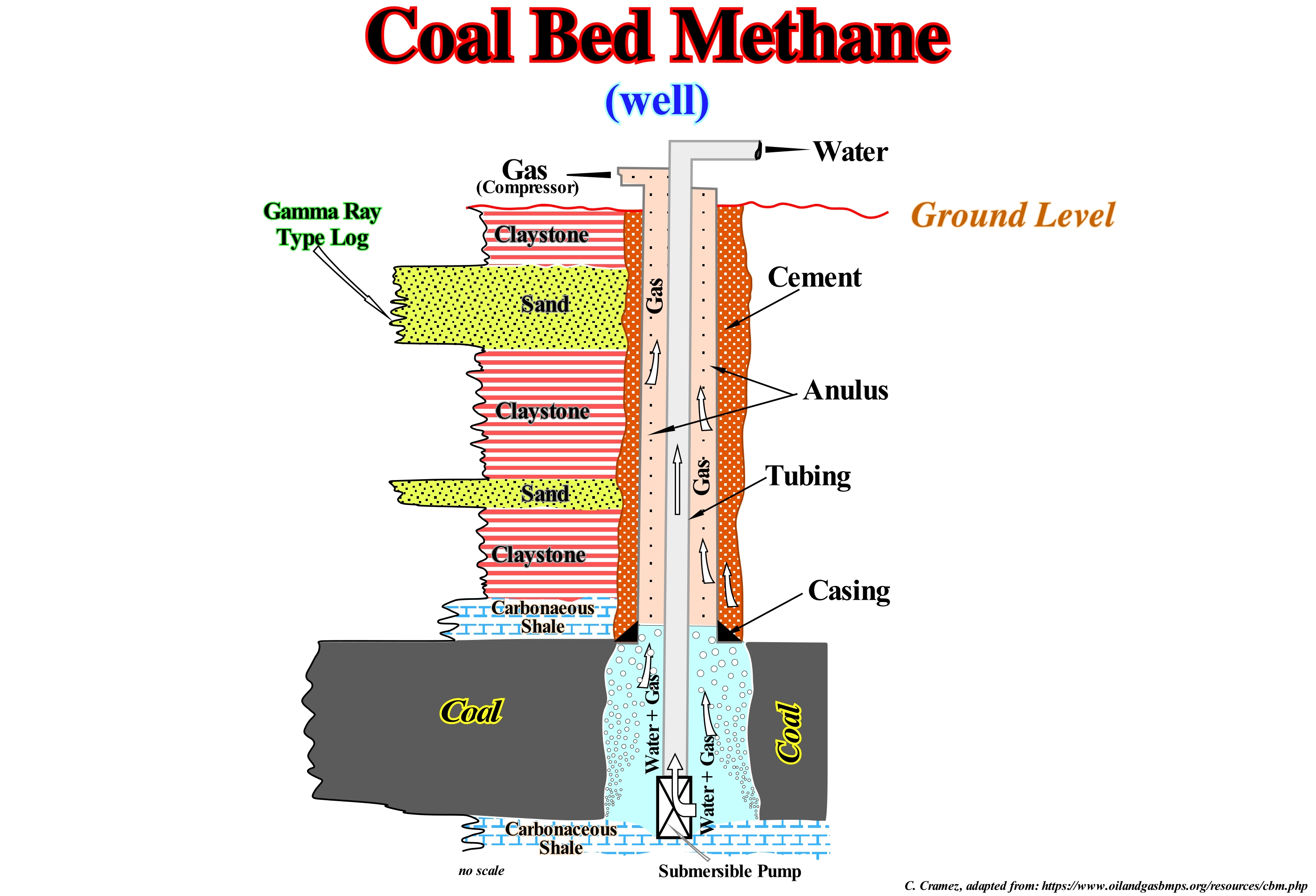
Recently, in the state of Montana, in the United States, a great controversy was created when certain oil companies announced the probable production of methane from the layers of coal that occur in the eastern part of the state. Such an announcement meant a good thing to the inhabitants of the region, since the production of gas from layered coal would provide energy for the heating of dwellings and water. On the other hand, such an announcement also meant, as many people forget, that the production of methane implies an enormous production of water, which is often polluted by a number of dissolved substances such as arsenic. When the vegetable material is buried and converted into coal, carbonization is accompanied by significant methane production. It is the presence of this gas in the layers of coal that causes the explosions in the coal mines that continue to kill a lot of people. As in the coal layers, a large amount of methane is found in the groundwater that fills the fractures and the pores of the coal, the geostatic pressure conserves the methane of the dissolved coal in the same way that the pressure conserves the carbon dioxide (CO2)in a bottle of coca-cola closed. In the same way that gas is released when a bottle of coca cola is opened, since a well hits the coal layer, the pressure decreases, and water and methane rise to the surface, but water, which is much more abundant than the gas has to be separated from the gas. Methane may be extracted by drilling coal seam (stratum of coal thick enough to be mined with profit). The methane adsorbed into a solid coal matrix (coal macerals) will be released if the coal seam is de-pressurised. Pumping water from the well, decrease the water pressure allowing methane to desorb* from the coal and flow as a gas up the well to the surface. To avoid putting methane into the water line, but allow it to flow up from de casing to surface gas compressor. If the water level is pumped too low during de-watering, methane may travel up the tubing into the water line causing the well to become "gassy". Although methane may be recovered in a water-gas separator at the surface, pumping water and gas is inefficient and can cause pump wear and breakdown. Methane is then compressed and piped to market. (https://en.wikipedia.org/ wiki/Coalbed_methane_extraction)
(*) Desorption is a phenomenon whereby a substance is released from or through a surface
Coal Oil.......................................................................................................................................................................................................................Huile de charbon
Petróleo de carvão / Petróleo del carbón / Kohle Öl / 煤油 / Полученная из битумного угля сырая нефть / Carbolio /
Liquid hydrocarbons produced from coal. The most, frequently, used method for such production is the Fischer-Tropsch reaction, which is a catalysed chemical reaction, in which the carbon monoxide (CO) and hydrogen are converted into liquid hydrocarbons. The most, commonly, used catalysts are at the base of iron and cobalt. The main purpose of this process is to produce a synthetic oil substitute, whether from coal or natural gas, to be used as the lubricating oil or synthetic fuel
See: « Oil »
&
« Coal »
&
« Fischer-Tropsch Reaction »
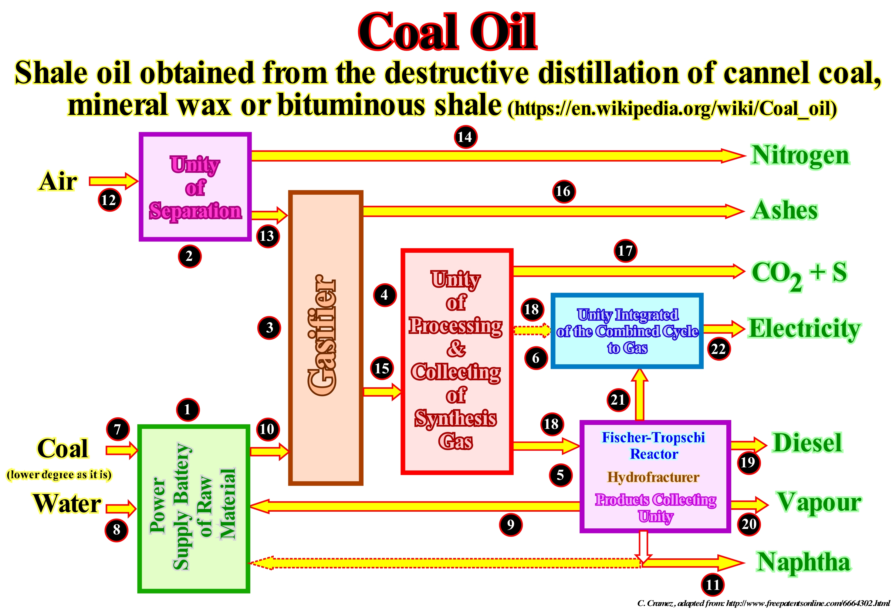
The coal gasification system can be made together with a Fischer-Tropsch reactor and an ICCG Unity (Integrated Gas Combined Cycle Unit). The main units of this operation are: (1) Battery Supply ; (2) Separation Unit ; (3) Gasifier ; (4) Synthesis Gas Treatment and Collection Unit ; (5) Fischer-Tropsch Reactor and Product Collection Unit ; (6) IGCC Unit. Lower grade coal (7) feeds the supply pile (1). Water (8) feeds the system. The wax (9) produced by the reactor (5) is mixed with the coal to form a wax impregnated with the feedstock which feeds the gasifier (10). The naphtha* produced by the reactor (5) can be mixed with the wax of the raw material (3) to increase the energy of the raw material. Air (12) feeds the separation unit (2) to supply oxygen (13) to the gasifier (3). Nitrogen by-product (14) is sold or used in another unit. The raw material impregnated wax (10) and the oxygen (13) feed the gasifier (3) to produce a synthetic gas such as it is (15) and ash (16). The ash may be sold as building material or sent for a discharge. The synthetic gas as such it is (15) feeds the treatment and collection unit (4) to produce sulphur, carbon dioxide (17) and clean synthesis gas (18). The clean synthesis gas (18) feeds the reactor, the hydrofracturer and the collection unit (5). The cleaned synthesis gas (18) can be burned by the IGCC (6) to produce electricity (22). The reactor, the hydrofracturer and the collection unit (5), produce diesel (19), wax (9), naphtha (11), steam (12) and tail gas which is burned at ICCG to produce electricity.
(*) Mixture of flammable liquid hydrocarbons. Mixtures of naphtha were produced from natural gas condensates, petroleum distillates and the distillation of coal tar and peat. In different industries and regions, naphtha may also be crude oil or refined products such as the kerosene.
Coalification..........................................................................................................................................................................................................Carbonisation
Incarbonização / Carbonización / Inkohlung / 煤化 / Карбонизация / Carbonificazione /
Increase in the carbon content and calorific value, as well as, the decrease in the moisture content of the volatile matter and oxygen of the carbonaceous material, when it is transformed from peat into lignite, bituminous coal and, finally, anthracite.
See:« Coal »
&
« Diagenesis »
&
« Coal Bed Methane »

Over time (geological), the remains of plants accumulate at the base of the swamps (leaves, branches, branches, roots, etc.). This accumulation (peat) undergoes an coalification in three phases: (i) Aerobic decomposition (in the presence of oxygen) ; (ii) Anaerobic decomposition (without oxygen) and (iii) Bituminization. The first one appears in the first few centimetres of burial, where active aerobic decomposition reduces the volume by about 50%. As the water is stagnant and the peat impermeable, the bacteria use all available oxygen and die by completing the first phase. In the second phase, other types of bacteria (which do not require oxygen) continue to decompose, further reducing the volume of peat. This decomposition produces acids, which means that during the first two phases the acidity increases. When the pH (measured as the acidity and basicity of a solution, which is defined as the co-logarithm of the activity of the dissolved hydrogen ions) reaches about 4, all anaerobic bacteria die. At this point, the peat becomes a dark-colored gelatinous mass, which continues to increase, while the bacteria continue their work at the higher levels. It is this material that will, eventually, be turned into coal. In the third phase (bituminization), the decomposition is thermal, which requires that the gelatine material of the peat be buried several tens of meters (function of the geothermal degree of the region). Since the temperature reaches about 100° C, the bituminization process begins. Chemical reactions eliminate water, oxygen and hydrogen, which increases the percentage of carbon. The degree achieved by bituminization determines the rank of coal. When the carbon reaches 85%, the initial peat becomes a sub-bituminous coal. At 90%, it has become bituminous coal and anthracite when the carbon content is 95%. During bituminization, plant remains are invisible to the naked eye, and bright black macerals (organic constituents of the coals) are preponderant.
Coast...........................................................................................................................................................................................................................................................................Côte
Costa / Costa (marina) / Küste / 海岸 / Побережье / Costa /
Band of land of indefinite width (can have several kilometers) extending from the line of the low-tide until the first important change of the morphology (cliff). Some geoscientists restrict the coast to the space reached by the waters between the extreme tides levels. The coastline or shoreline is a, relatively, vague term, since it is not fixed due mainly to the tides.
See: « Onshore »
&
« Shoreline »
&
« Littoral »
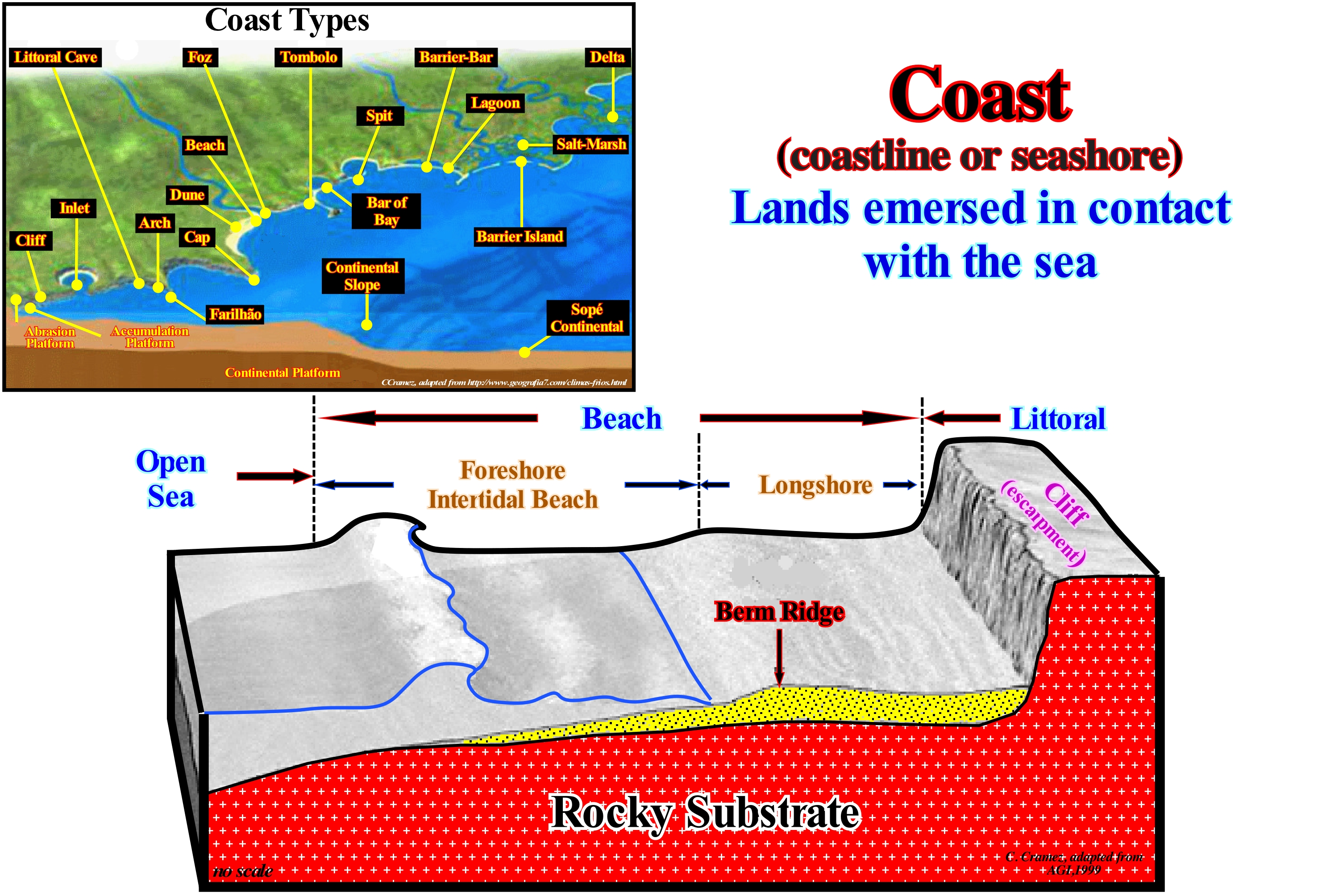
The coast is the part of the continent considered as close to the littoral, which includes, often, the coastal plain. The surface hit by the sea-waves is modelled on steps called beach-steps, which are formed by a small beach "platform" or berm and an abrupt. The line of inflection between the berm and the abrupt of each step is the crest of the berm. The berm is a low bench that is, almost, horizontal or sloping toward the continent, not permanent and formed by material transported and deposited by storm-waves. The crest of the berm marks, often, the beginning of the foreshore. The coast is, often, considered as the first defensive frontier of a country. Although the coastline varies daily, depending on the tides, it is common to consider the following types: (i) Emergent Coastline, when it results from a relative sea level fall, which is, easily recognized, by topography, such as, for instance, the suspended beaches (or raised beaches)once they are not hit by the full tide ; (ii) Submergent Coastline, when it is the result of a relative sea level rise, which is recognized by drowned platforms (platforms covered by sea-water, which place them, often, under the photic zone), rias ( drowned valleys) and fjords; (iii) Concordant Coastline, when it is, more or less, parallel to the stratification plans and boundaries between the different rocks that form the cliff ; (iv) Discordant Coastline, when it is oriented obliquely or even perpendicular to the direction of the geological formations that form the coast. It is in this last type of coastline that the inlets (entrances) and the bays are frequent. The less resistant rocks are, more easily, eroded and the geological formations more resistant to the erosional agents, in particular, to the sea-waves, form promontories and important outcrops, which make the joy of the geoscientists.
Coastal Aggradation....................................................................................................................................................Aggradation côtière
Agradação costeira / Agradación costera / Küsten Verlandung / 沿海沉积 / Береговой намыв / Aggradazione costiera /
Vertical component of coastal onlaps. Coastal aggradation underscores relative sea level changes. It is positive, when the relative sea level rises and negative when the relative sea level drops. When coastal onlaps are dispolaced seaward and downward, they emphasize lowstand geological conditions. In a sequence-cycle, except for turbidite deposits (deposited in the Vail hypothesis, during relative sea level falls), a relative sea level rise is required for the deposition of highstand systems tracts (transgressive interval and highstand prograding wedge) and the lowstand prograding wedge (subgroup of lowstand systems tracts group). All these deposits have a positive coastal aggradation. In a sequence-cycle, during the deposition of the transgressive interval (TI), the rate of relative sea level rise is in acceleration, whereas, during the deposition of the highstand prograding wedge (HPW), it is in deceleration.
See: « Aggradation »
&
« Onlap »
&
« Systems Tract »
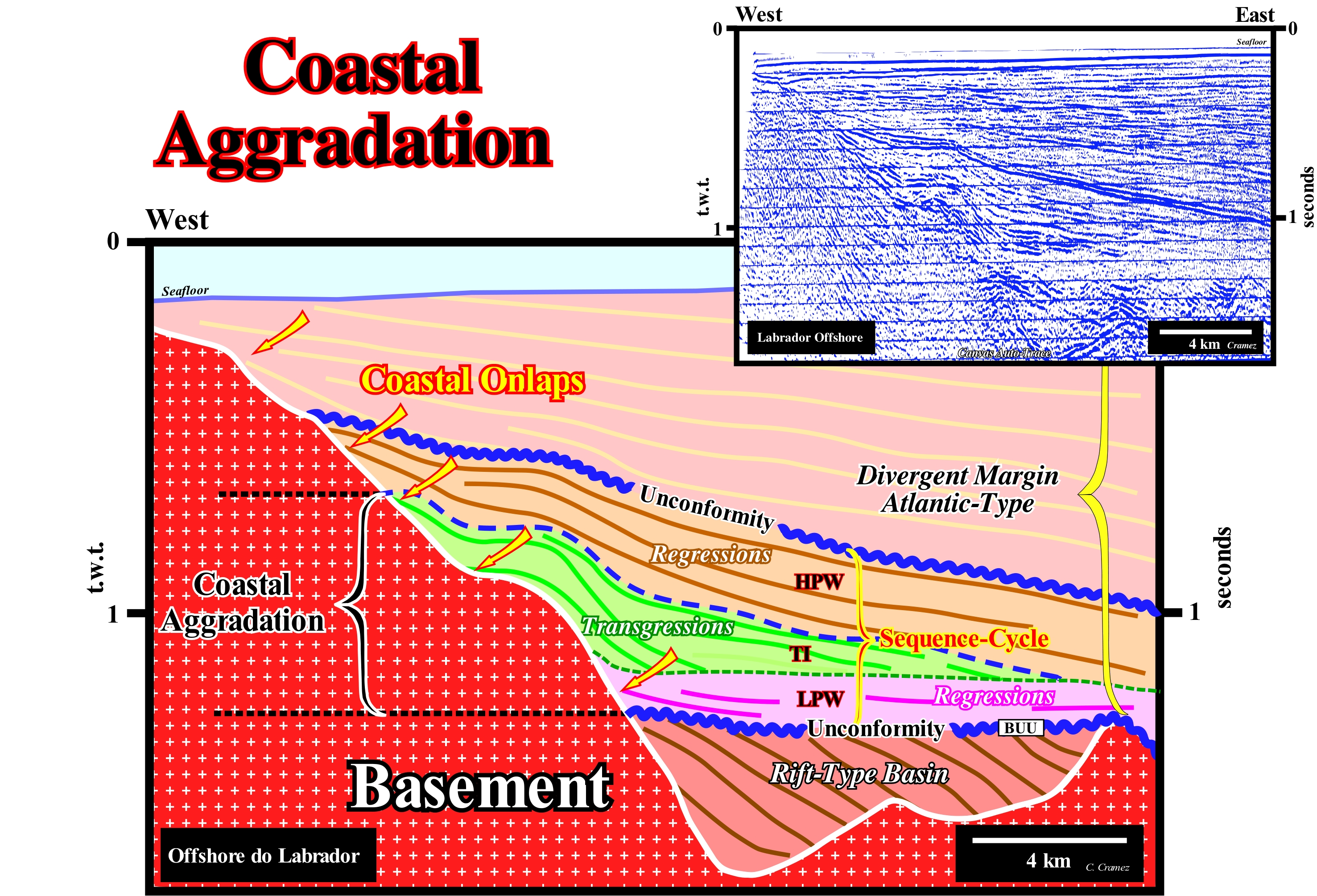
A positive coastal aggradation occurs during the transgressive and regressive episodes of a sequence-cycle. An increase in available space for sediment (shelfal accommodation) is required in both cases. In transgressive episodes, the rate of increase of available space is in acceleration, i.e., marine ingressions are increasingly important (sectors of the relative sea level curve with increasing and concave geometry) whereas during the s regressive episode, it is in deceleration : the marine ingressions are increasingly smaller (sectors of the relative sea level curve with increasing and convex geometry). According to Vail, turbidite depositional systems (submarine basin floor fans and submarine slope fans) are deposited during relative sea level falls (negative coastal aggradation) since, within a sequence-cycle, seaward of the continental edge, the water-depth is sufficient to allow deposition. On this tentative geological interpretation of a Canvas auto-trace of a detail a seismic line Labrador offshore (Canada), which is formed by a Mesozoic-Cenozoic divergent margin (Atlantic-type) deposited above Late Jurassic-Early Cretaceous rift-type basins, take into account the isostatic or post-glacial adjustment* (rebound). In the suggested sequence-cycle (between the two unconformities coloured in blue), the coastal aggradation is well visible, in the transgressive interval (TI), which is characterized by a retrogradational geometry. The overlying regressive episode (highstand prograding wedge, HPW) is characterized by a progradational geometry. A 3rd order eustatic cycle, whose time-duration ranges between 0.5 and 3-5 My induced the deposition of the sequence-cycle, which is bounded, as all stratigraphic cycles, by unconformities. The transgressive interval (TI) is associated with the segment of the relative sea level curve, around the inflection point and. particularly, with the upper segment characterized by positive 1st and 2nd derivative (sector of the relative sea level curve with a concave and crescent geometry), which suggests a relative sea level rise in acceleration (marine ingressions are increasing or, in other words, by increasing rate of the space available for sediments). The regressive episode (HPW) is associated with the sector of the relative sea level curve with a positive 1st derivative and negative 2nd (the function is growing and convex), i.e., associated with the relative sea level rise in deceleration (marine ingressions are increasingly smaller smaller or the accommodation rate is getting smaller). The lowstand systems tracts group (LSTG) is, mainly, deposited in association with the decreasing and concave segment of the relative sea level curve (falling in deceleration). In a sequence-cycle, it is wrong to associate the transgressive interval (TI) with a relative sea level rise and the highstand prograding wedge (HPW) with a relative sea level fall. The sedimentary systems tracts forming these subgroups require, always, an increase of shelfal accommodation, which implies a relative sea level rise. What changes is the rate of rising (in acceleration during the transgressive interval and in deceleration during the highstand prograding wedge). The BUU unconformity ("Breakup Unconformity"), which separates the rift-type basins from the overlying Atlantic-type divergent margin, emphasizes the breakup of the lithosphere of the Pangea supercontinent. The sedimentary interval between blue coloured unconformities corresponds to a sequence-cycle. The age difference between these unconformities is less than 3-5 My. However, such a sequence-cycle is incomplete. The lowstand systems tracts group (LSTG) is represented just by the upper sub-group, i.e., by the lowstand prograding wedge (LPW). The other sub-groups, i.e., the submarine basin floor fans (SBFF) and submarine slope fans (SSF) were not deposited in this area. Within this sequence-cycle, it is easy to see that 1st transgressive surface (dashed green) separating the lowstand prograding wedge (LPW) from the transgressive interval (TI), as well as, the major downlap surface (dashed blue) separating the transgressive interval (TI) from the highstand prograding wedge (HPW).
(*) Uplift of land masses that were pressured by the enormous weight of glacial caps and glaciers during the last glaciation, through a process known as isostasy depression.
Coastal Encroachment.............................................................................................................................................Empiétement côtier
Invasão costeira / Invasión costera / Coastal Übergriff / 海岸侵蚀 / Затопление берега / Invasione Costiera /
Horizontal distance between two consecutive coastal onlaps. It indicates the morphology of the unconformity that coastal onlaps define. The flatter the morphology of the unconformity, landward of the basin edge, the greater is the continental encroachment that, in this case, is coastal. It can be positive (relative sea level rise) or negative (relative sea level fall).
See: « Relative Sea Level Change »
&
« Aggradation »
&
« Continental Encroachment »
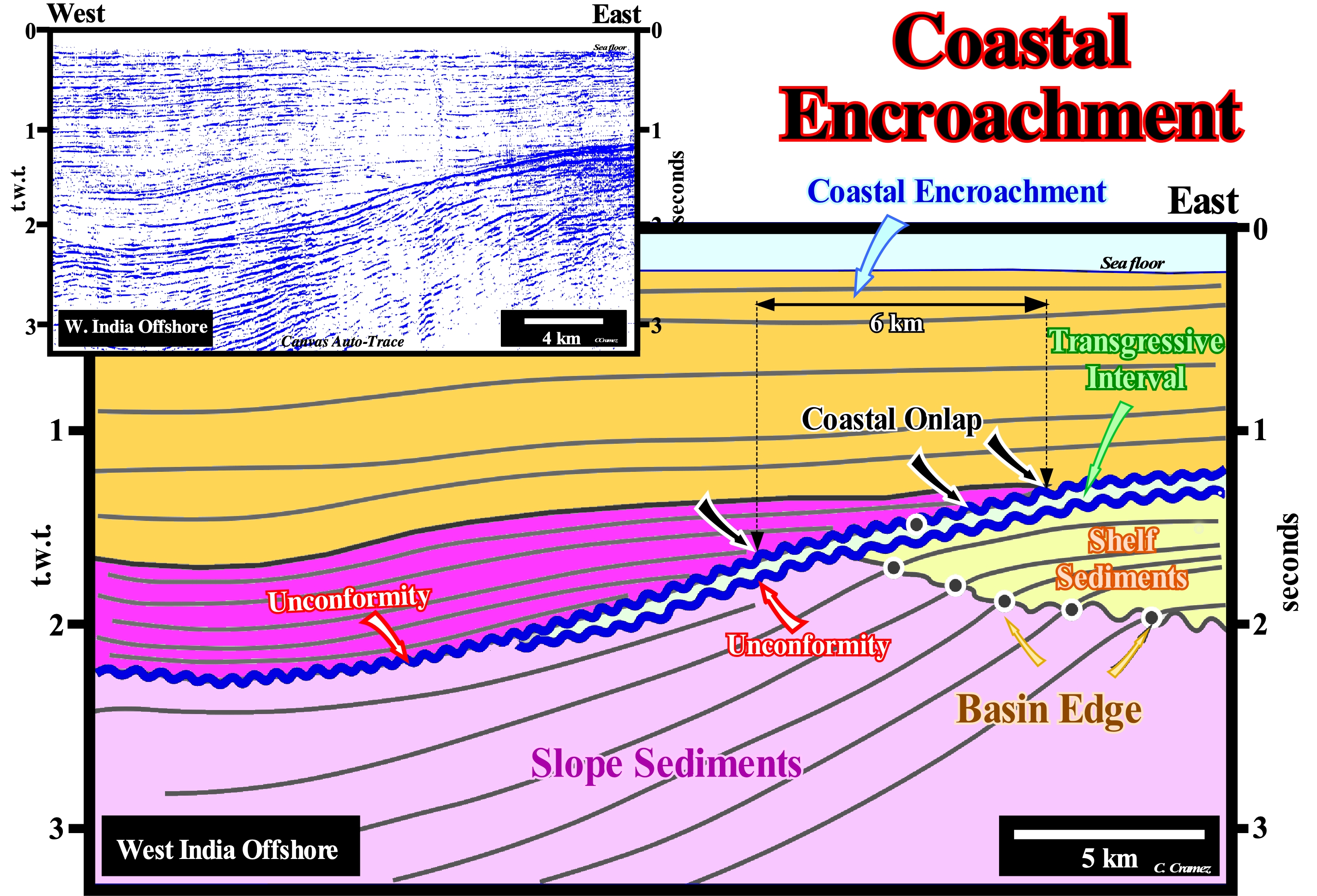
A coastal encroachment is a particular case of continental encroachment. It corresponds to the horizontal distance (in meters) between two consecutive coastal onlaps. A marine encroachment corresponds to the horizontal distance (in meters) between two consecutive marine onlaps. The combination of coastal encroachment and aggradation (vertical distance in milliseconds between two consecutive coastal onlaps) emphasizes, roughly, the topography of the unconformity against which the sediment rests. If coastal aggradation is small (let's say, 50 milliseconds) and coastal encroachment very large (over 50 km), the morphology of the erosional surface created by the relative sea level fall is very flat and on the seismic lines it will be difficult to identify and differentiate the depositional coastal break of the depositional surface (more or less, the shoreline) from the basin edge, particularly, during the highstand systems tracts sub-groups (transgressive interval and highstand prograding wedge) of a sequence-cycle. Within a sequence-cycle, in the highstand prograding wedge (regressive episode, since the relative sea level* rises in deceleration i.e., increasingly smaller marine ingressions and increasingly important sedimentary regressions), from a certain point, the depositional coastal break moves seaward until reach the basin edge. From such a moment on, the basin has no shelf (2nd phase of development of the highstand prograding wedge). On this tentative geological interpretation of a Canvas auto-trace of a detail of a seismic line of West India offshore (volcanic continental margin** overlying a continental crust, in which rift-type basins developed before the breakup of the lithosphere of the small Gondwana supercontinent). At the top of the lowstand prograding wedge, the coastal encroachment, is about 6 km and the aggradation about 200 milliseconds double time (± 100 m at this depth). A divergent continental margin is considered volcanic when sub-aerial volcanism is implemented at the base of the margin,i.e., immediately. after the breakup of the lithosphere and before the formation of the oceanic crust. Since relative sea level rise changed the geological conditions to highstand, the coastal encroachment of the first flooding surface is likely to exceed 100 km and the aggradation less than 100 milliseconds. The increase in coastal encroachment (for values similar to those of the aggradation) underlines the morphology of the underlying unconformity and the location of the old basin edge. The first onlap of the lowstand prograding wedge marks the negative aggradation induced by the the relative sea level fall that created the unconformity. The submarine fans, and in particular the submarine basin basin floor fans (SBFF), are deposited in the deep part of the basin (where there is sufficient space available for the sediments) during the relative sea level fall. However, all other intervals (sub-groups of sedimentary systems tracts) of a sequence-cycle require a relative sea level rise to increase shelfal accommodation in order to settle down the transported sedimentary particles. Since the break-up of a supercontinent, the volume of the ocean basins, due to the sea floor spreading, will decrease (the volume of the oceanic ridges increases), which implies an absolute or eustatic sea level rise (supposed global and referenced to the Earth centre). This rise in absolute sea level continues during the dispersion of the continents individualized by the breakup of the supercontinent. The absolute sea level begins to fall, since the volume of the ocean basins increases due to the subduction of the oceanic crust along the subduction zones. This type of absolute sea level changes is called Tectono-Eustasy. Absolute sea level changes, which control the continental encroachment cycles and, probably, some of the continental encroachment subcycles, are dependent on: (i) Tectono-Eustasy, which is controlled by the volume variation of the ocean basins ; (ii) Glacio-Eustasy, which is controlled by the variation of ocean water volume as a function of the amount of ice ; (iii) Geoidal-Eustasy which is controlled by the distribution of ocean water caused by variations in the terrestrial gravity field, and (iv) Thermal expansion of the oceans or Steric sea level rise (if the temperature of the oceans increases, the density of the water decreases and, for a constant mass, the volume increases).
(*) The relative sea level is the local sea level, referenced to the sediment base (top of the continental crust) or to the sea floor. It is the result of the combined action of the absolute (eustatic) sea level (supposed global and referenced to the Earth centre) and the tectonics (subsidence or uplift of the sea floor).
(**) A divergent margin is said volcanic when, after the breakup of the supercontinent, the divergent margin begins with the implementation of volcanic sub-aerial flows ("SDRs", i.e., Seaward Dipping Reflectors). At present, it is known that the vast majority of the divergent margins, especially those of Atlantic type, are volcanic, which was not the case a few years ago, when all Atlantic margins were considered as non-volcanic, following some publications on the Galicia Offshore.
Coastal Karst...........................................................................................................................................................................................................Karst littoral
Carso litoral / Karst litoral / Küstenkarren, Küstenkarst / 沿海岩溶 / Прибрежный карст / Carso costiero /
Set of karstic forms developed in the strand and supra-littoral zone. Although the dissolution of calcium carbonate varies, inversely, with temperature due to intense biological activity, coastal kart forms are more frequent and more developed in the intertropical coasts. Coastal karstic forms are arranged in streaks parallel to the coastline and differentiated with the time of immersion-submersion to which they are subjected (Moreira, 1984).
See: « Karst »
&
« Erosion »
&
« Wave Base »
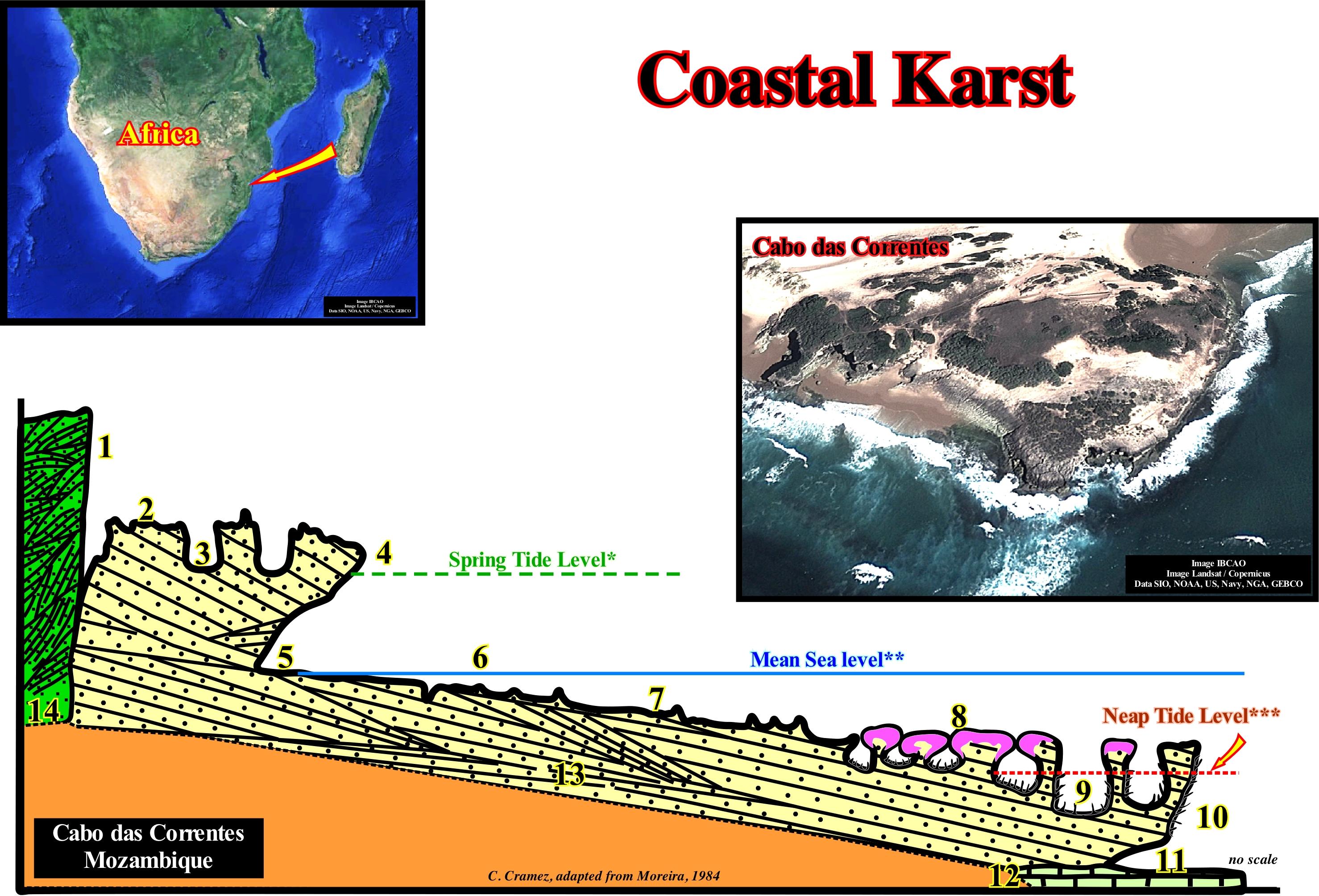
This geological cross-section of Cabo das Correntes (Mozambique) illustrates the zoning and main types of micro-forms of the coastal karst in sandy rocks, particularly, in aeolianites (consolidated sedimentary rocks composed of clastic material deposited by the wind). From the continent seaward, it is recognized: (1) Abandoned Cliff with corrosion honey-combs; (2) Platform with littoral clints ; (3) Coastal Potholes or water-pockets ; (4) Visor of active cliff; (5) Undercut, groove or notch; (6) Platform with solution benches and embryonic water-pockets; (7) Platform with solution benches encrusted with calcareous algae ; (8) Platform tubular bioconstructed ; (9) Coastal potholes (water-pockets); (10) Overhanging surface cornice; (11) Submerged undercut (notch, groove) ; (12) Dead coral bank. Note (13) underlines the beach sandstone and (14) aeolianites. In littoral limestones, as those in Mediterranean, numerous under-water sources, often of brackish water, are associated with the saline crisis that occurred in Messinian (about 5.5 million years ago). This crisis stresses a very important relative sea level fall (locally, around 1,500 meters), which was caused by the closing of the Straits of Gibraltar and a strong evaporation. The relative sea level fall was responsible for a deep karstification, caused by deep incisions in the main valleys, such as the Rhone canyon, which is now, completely, filled with Pliocene marine and continental sediments. These sediments fill the karst aquifers, whose exits are now artesian sources. Such conditions can increase the permanence of groundwater for several thousands of years (the normal permanence of an aquifer in a well developed karst zone is about one year) and favour not only the discharge of fresh water (< 50 m depth), but also the entry of sea-water into the aquifers which creates sources of brackish water.
(*) Tides occurring during the syzygies (more or less straight-line configuration of three or more celestial bodies in a gravitational system), characterizing themselves, for each location, by the highest amplitudes. To the spring tides that occur near the equinoxes, accusing the maximum amplitude values, they are called equinoctial tides.
(**) Sea level varies quite a lot on several scales of time and distance. It is affected by the tides, wind, atmospheric pressure, local gravitational differences, temperature, salinity, subsidence, etc.. To determine the “mean sea level”, the best one can do is to pick a spot and calculate the mean sea level at that point and use it as a datum. Generally, a period of 30 years of hourly level observations may be averaged and used to determine the mean sea level at such a measurement point (an average whether it is sea level or temperature, to have meaning it must cover a rather long period: the World Meteorological Organization (WMO) recommends that it covers 30 years, from there one can speak of « normal »). As “sea level rise” is considered one of the most familiar effects of climate change, and the one with perhaps the biggest consequences, is essential to precise what level of the sea is considered and how it was calculated.
(***) Neap tides are tide that occurs during the lunar quadratures (configurations of a celestial object in which its elongation is perpendicular to the direction of the Sun), being characterized, for each location, by the minimal amplitudes.
Coastal Lapiaz (Littoral clints)..................................................................................................................Lapiaz, Lapiez (Lapies littoraux)
Lapiaz litoral / Lapiaz / Rüstenkarren, Litoral Schratten / 升级车 / Прибрежный карр / Karren /
Surface geological formation, in calcareous and dolomitic rocks, created by the flow of rain-water, which dissolves the rock or by cycles of ice and melting inside the rocks (frost weathering).
See: « Littoral »
&
« Karst »
&
« Fair Weather Wave Base »
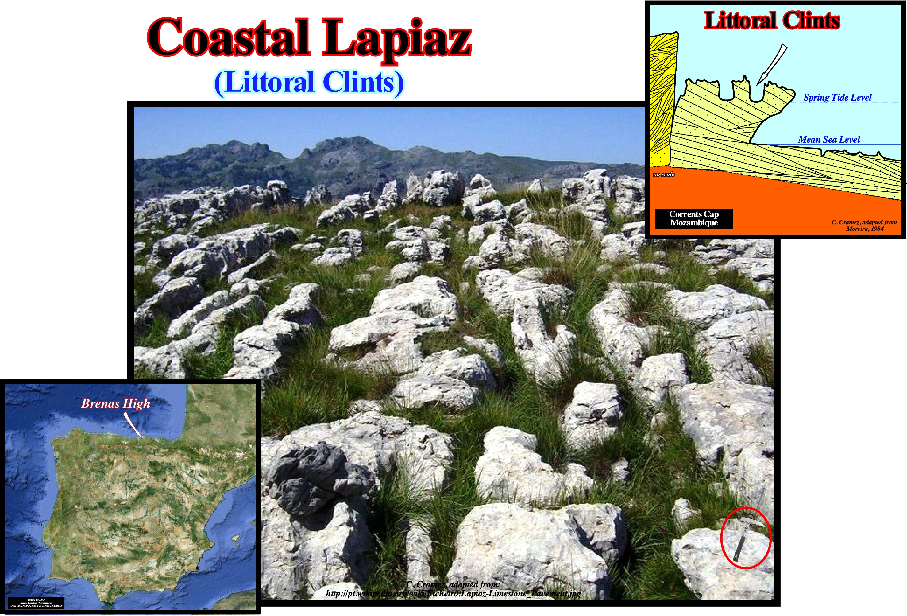
The alteration of limestone by water, essentially, consists of dissolution. In limestone rocks, the dissolution is opposed to glyptogenesis (erosion), especially abrasive, of crystalline and detritical rocks, as well as to the lateritic process, which is chemical in nature. On the surface of a limestone, the simplest dissolution processes are small funnel-shaped holes, which are, often, observed, but soon coalesce to form small pits (drains), which with time become deeper and deeper to finally form the lapiaz, as those illustrated in this figure (Brenas High in Cantabria, Spain). The grooves of the lapiaz can be of two types: (i) Drains, which line up according to the line of greatest inclination and are generally straight or sinuous ; (ii) Cracks, which correspond to a deepening of the fissure and that cut the rock into blocks. The lapiaz may be: (a) Laid bare by the glaciers, sub-aerial, formed, mostly, by narrow parallel grooves with sharp corners ; (b) Covered by humus or a recent soil and formed of rounded corners and grooves ; (iii) Uncovered and, in general, coming from covered loops, but without soil cover. This type of lapiaz, that could be called continental lapiaz, is not to be confused with the coastal lapiaz or littoral clints developed in the strand (upper meso-littoral zone) and in the supra-littoral zone of the calcareous coastlines, as, for instance, those illustrated in the sketch on the left of this figure. The coastal lapiaz can take the form of pinnacles, with sharp edges, leaving between them small kettles of dissolution, sometimes in the form of funnel. In the higher part of the strand, due to the runoff of the drops of sea-spray and the foam of the waves, the lapiaz are, sharply, cut and with very erosive furrows. In the inter-tropical regions these forms are very developed and have, sometimes, the appearance of ruin fields (Moreira, 1984). The lapiaz generated in the underground tend to take on more sweetened and larger forms, unlike the surface generated lapiaz.
Coastal Marsh (Salt marsh).................................................................................................................................................................Marais salant
Pântano de maré (pântano marinho, pântano costeiro)/ Marismas salinas, Marjales / Marsch, Watt / 沿海湿地 / Солончаковое болото / Palude costiera /
Region saturated with water, poorly drained and covered, intermittently or permanently, by water with a vegetation similar to grass but, fundamentally, without peat formation.
See: « Oxbow Lake »
&
« Overbank Deposit »
&
« Flooding Plain »
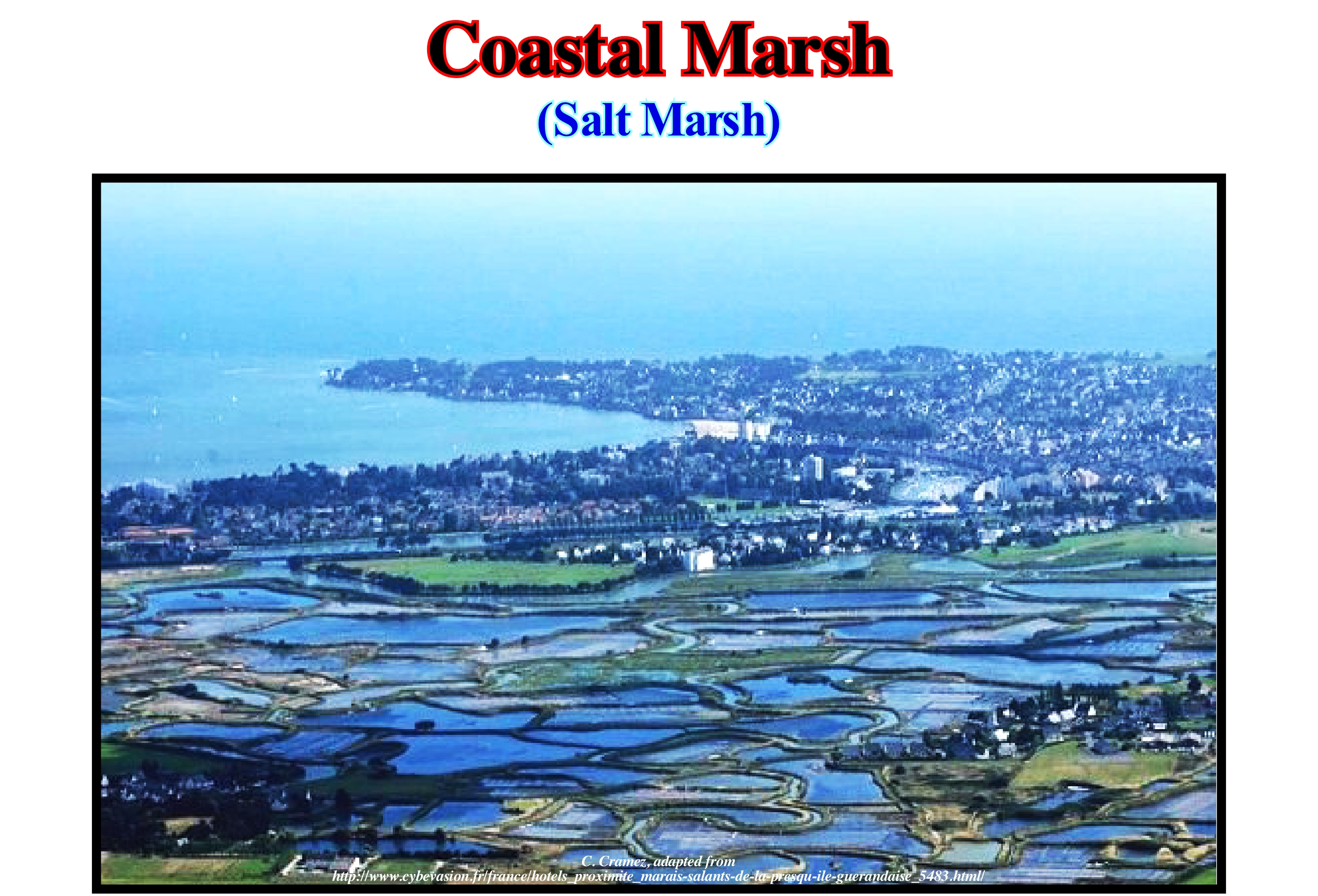
The coastal marshes and estuaries have numerous common points. Both are characterized by the existence of channels carved by tidal currents and sedimentation zones. The origin can be found in a transgression, which flooded not only part of the zones lower than the river mouths (coastal marshes), but also a part of the mouths (estuaries). The occurrence of a transgression is not indispensable for the formation of the coastal marshes or estuaries. They can form without submersion or emersion of the coastal zone (neutral coasts). Coastal marshes can be formed by lateral siltation, in the protected part of the estuary, behind a barrier bar or a dead-end bay. Sedimentation is, in most cases, very complicated and largely sandy and muddy. Most of the time, the vegetation fixes the mud, as illustrated in this photograph. These swamps contain, usually, few if any trees or shrubs and have, sometimes, year-round water acting as natural filters. While water is parked in the swamp, the infiltration water flow is retarded and the suspended sedimentary particles are deposited, which corresponds to a filtration of the water. The mud, when little colonized and covered several hours at each tide, is called "slikke". When it is colonized by the vegetation it is a "schorre", that is to say, a dry, granulated mud that is covered only for brief moments. Often, the tide just occupy certain meandering channels. Fresh-water peat is formed only inside the marsh, where the water is sweet. A change in channel trajectories or a rupture in the barrier bar, which closes the swamp, can deposit marine sediments over the fresh- water peat without any transgression occurring. The peat is compacted rapidly, and the swamp is, gradually buried, which causes a marine invasion without any tectonic event occurring. All these possibilities must always be taken into account when making the morphological history of coastal marshes (Derruau, M., 1958).
Coastal Non-Marine Deposit.......................................................................................................Dépôt côtier non-marin
Depósito costeiro não-marinho / Depósito costero no-marino / Coastal nicht - marinen Ablagerung / 沿海非 - 海相沉积 / Прибрежные не-морские отложения / Deposito costiero no-marino
Deposit located upstream of the depositional coastal break of the depositional surface (more or less the shoreline) and downstream of the bay-line (upward limit of the of the Posamentier and Vail coastal wedge or costal prism). Coastal plain and flood-plain deposits are the most frequent non-marine coastal deposits, which are, relatively, little controlled by relative sea level changes and deposited in a sedimentary environment that is not, properly, marine.
See : " Fluvial Deposition "
&
" Shoreline "
&
" Coastal Plain "
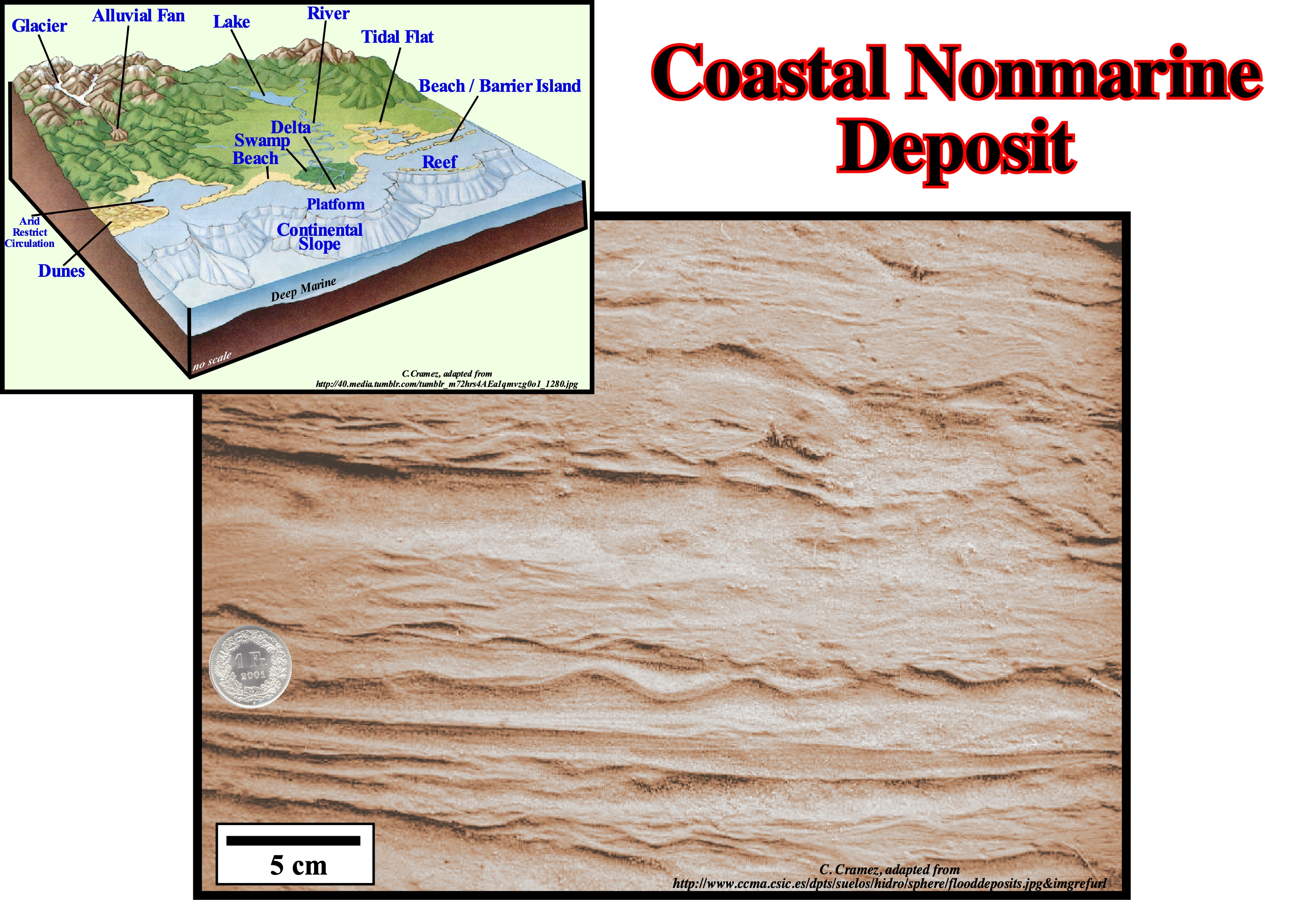
Flooding deposits are formed by sedimentary particles (clay, gravel, sand and mud) transported by a water-current, usually, a river, which remain in a non-consolidated form until lithification (a set of processes that convert sediments to sedimentary rocks, more or less, consolidated). The depositional systems associated, most often, with flooding deposits are channel filling and overbank deposits, induced by a significant increase in seasonal fluvial discharge caused by snow melting, excessive rainfall, or monsoon* conditions. These non-marine coastal deposits are characterized by a very diffuse stratification and a near absence of structures, which is interpreted by many geoscientists as the result of a rapid deposition from a decelerating stream of the upstream flank of large anti-dune** flows, as well as in hydraulic jumps (when a high-speed stream discharges into a lower speed zone). The deposits of river flood-plains, as shown in this figure (Rio Segres, Spain) can be considered as non-marine coastal deposits. They are, mainly, composed of solid sands of fine to medium granulometry and parallel, oblique or crossing laminations (the finest intervals recognized in sedimentary rocks that differ from one another by colour, composition or grain size). Upward laminations indicate upstream flow, i.e., in a low energy flow zone, which moves away from the main stream. The colour changes observed in these sediments indicate they have different origins. In sequential stratigraphy, the concept of the non-marine sedimentary environment is based on the depositional base level, which is the relative sea level position***, which is controlled by the joint action of absolute or eustatic sea level (supposed global sea level, referenced to the Earth's centre) and tectonics (subsidence or uplift of the sea floor). The action of the sea-waves, i.e., the depth of the erosive action of the waves, is taken, almost always, as insignificant. The depositional base line level, which lies, more or less, near the sea level and sediment transport, are the main parameters controlling the distribution of non-marine deposits. Coastal deposits and areas located above the upper limit of the pre-estuary are considered as coastal non-marine environments. As illustrated in the geological sketch, several non-marine depositional systems can be considered: (i) Low Fluvial Systems ; (ii) Wind Systems ; (iii) Delta Systems (certain parts) ; (iv) Coastal Systems ; (v) Beach Systems (certain systems). As all these depositional systems are located near the shoreline, they are directly influenced by relative sea level changes, which are the main factor of the cyclicity of the paralic deposits. On the other hand, depositional systems associated with glaciers, alluvial fans and lake systems, as well as, fluvial deposits (upstream of the Posamentier and Vail bay-line) are little influenced by relative sea level change.
(*) A typical phenomenon in South and Southeast Asia, where the climate is conditioned by masses of water as they travel from the interior of the continent to the coast or from the coast to the continent. As the continent absorbs heat faster than ocean, during the summer, the warmer air on the continent, induces strong winds loaded with humidity coming from the ocean that produce heavy rains. During the winter is the opposite.
(**) An anti-dune is a form of the stratum found in fluvial environments and other channelled environments. Anti-dunes occur in the super-critical flow, which means that the Froude number (number without dimensions that refers to the effect of gravity forces and inertial forces acting on a fluid) is greater than 1.0 or that the velocity of the flow exceeds the wave velocity (upper flow regime). In an anti-dune, a sedimentary particle is deposited on the upstream side and eroded on the downstream side of the flow. As a result, the anti-dunes migrate in an upward direction, contrary to the current flow.
(***) Sea level, local, referenced to any point of the Earth's surface that may be the sea-floor or the base of the sediments (top of the continental crust). The absolute (eustatic) sea level is the supposed global sea level referenced to the Earth's centre measured, often, from a radar satellite by interferometry (family of techniques in which waves, usually elerctromagnetic waves, are superimposed, causing the phenomenon of interference, which is used to extract information). Note that a radiation is reflected by all obstacles whose size is comparable to its wave-length. The visible light has a wave-length, slightly smaller than a micron, while a radar radiation has a wave-length of about 5.6 centimeters. In this way, the clouds let pass this type of radiation, which is not the case of the irregularities of the soil. As a radar satellite emits an electromagnetic radiation to the Earth and records the echo sent back, it offers a stable observation point, i.e., a reference level allowing the elimination of local disturbances and rapid fluctuations. Instead, it allows to measure small and large phenomena with the same millimetre accuracy as waves, tides, and seasonal fluctuations can exceed a thousand times these values.
Coastal Ocean..........................................................................................................................................................................................................Océan côtier
Oceano costeiro / Océano costero / Küsten-Ozean / 沿海海洋 / Прибрежные океанские воды / Oceano costiero /
Part of the ocean near the mainland, generally, with a depth less than 200 meters, which is influenced by human activity. The coastal ocean is the part of the ocean between the outer edge of the continental shelf and the sea-influenced river area, whose importance increases as the number of people living near the coast and living off the sea resources, increases.
See: « Physiographic (province) »
&
« Blue Ocean »
&
« Major Storm Wave Base »
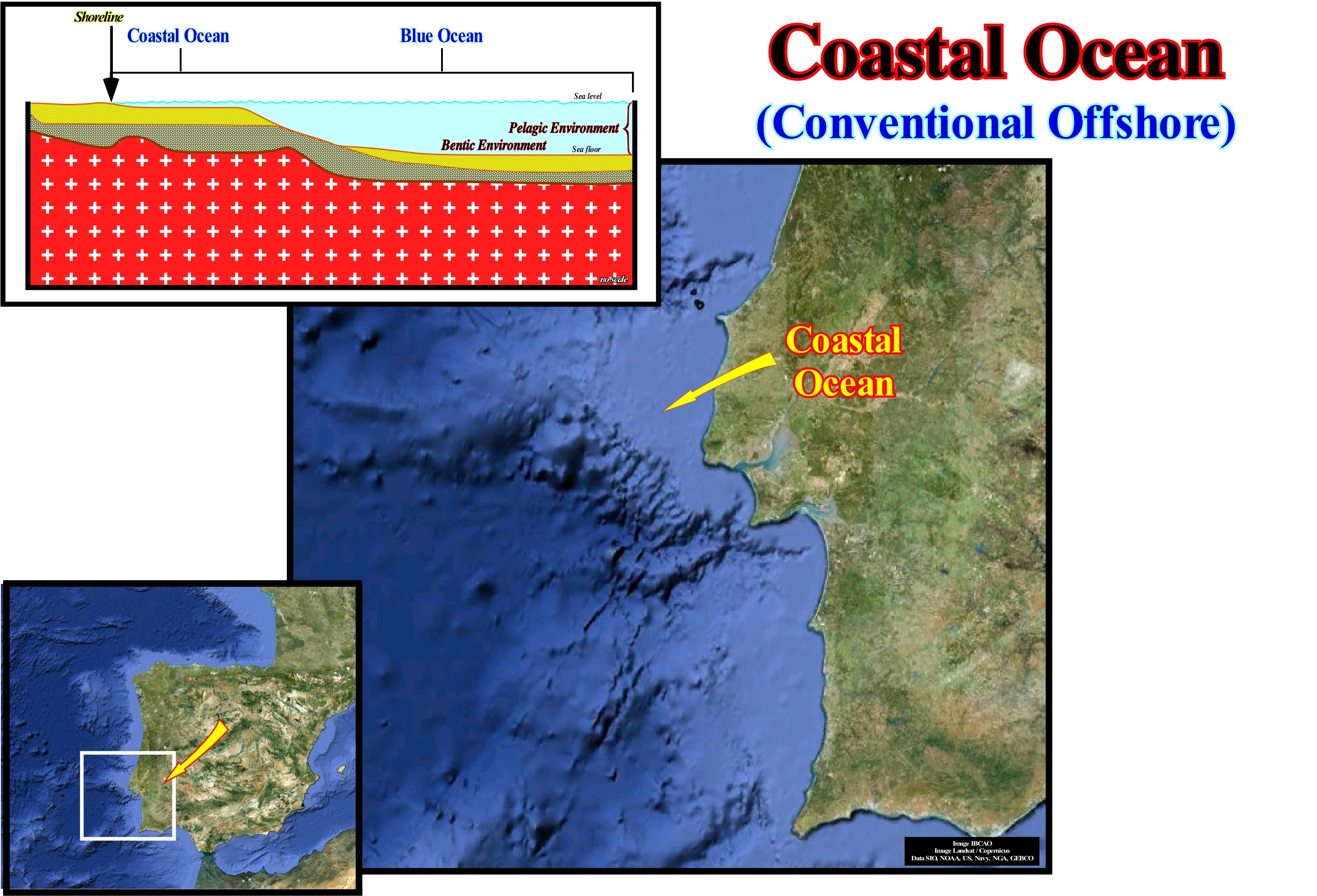
Although the oceans cover 71% of the Earth, only about 7% is occupied by the coastal ocean, which is the part of the ocean that most influences and which is most influenced by human activity. The importance of this narrow strip of sea, extending from the outer edge of the continental shelf to the furthest upstream salt-water penetration, increases as more people live near the coast and draw resources from the water. Coastal waters are important, for reasons including time, national defence, transportation, fishing, human health, margin risks, and mineral extraction. Man affects the coastal ocean through fishing practices, industrial pollution, habitat changes and agricultural runoff. And these environments affect us through food supply, water quality, proliferation of toxic algae and waste-water accumulation. The coastal ocean is the biologically most productive part of the ocean. Nutrients from the deep-ocean and continent come to the shallow-waters where there is enough light for the plants to grow. Some mechanisms for carrying these nutrients are well understood, but we know, in general, very little why our coasts are so productive. In sequential stratigraphy, the coastal ocean corresponds to the water layer where the so-called platform sediments are deposited, i.e., when the relative sea level (eustasy plus subsidence or uplift of the sea floor) rises or when shelfal accommodation increases (space available for sediments), all the space created is filled by sediments, which is not the case seaward of the platform edge. Under these conditions, the water sheet is kept more or less constant.
Coastal Onlap......................................................................................................................................................Biseau d'aggradation côtier
Bisel de agradação costeiro / Bisel de agradación costero / Coastal Onlap, Bevel Coastal Verlandung / 海岸上超 / Береговое подошвенное налегание / Bisello d’aggradazione costiero, Onlap costiero /
Onlap of a coastal stratigraphic (or seismic) unit that invades, progressively, the continent. This type of onlap is, largely, preponderant in the highstand systems tracts (transgressive interval, TI, and highstand prograding wedge, HPW), as well as, in the lowstand prograding wedge (LPW) of a sequence-cycle.
See: « Onlap »
&
« Depositional Coastal Break »
&
« Aggradation »
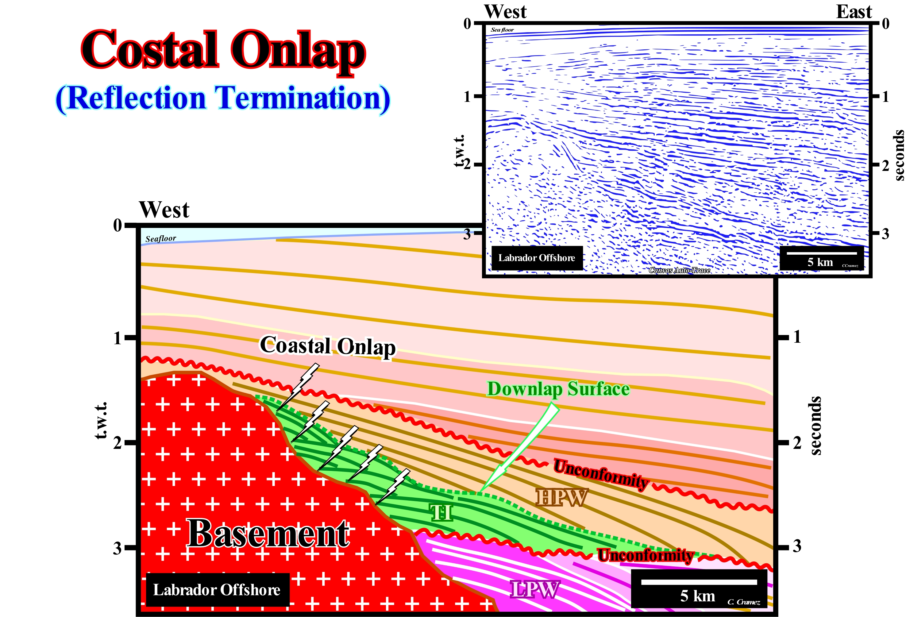
The Labrador offshore (Canada) corresponds to the stacking of three types of basins of the classification of the sedimentary basins of Bally and Snelson (1980). On regional seismic lines, three great intervals are recognized, that from bottom to top, are: (i) Basement or a folded belt mountains (Precambrian supracrustal rocks) ; (ii) Rift-type basins (Early Jurassic/Early Cretaceous), which developed during the lengthening of the small supercontinent Laurasia and (iii) Mesozoic/Cenozoic Atlantic-type divergence margin, which has formed since the break-up of small supercontinent Laurasia in different continents. In stratigraphic terms, the Mesozoic/Cenozoic divergent margin of this offshore corresponds to the post-Pangea** continental encroachment stratigraphic cycle, which was deposited in association with the second Phanerozoic first order eustatic cycle. On this tentative geological interpretation of a Canvas auto-trace of a detail of a Labrador offshore seismic line, coastal onlaps are evident. They are underlined by the reflector terminations (lapouts) against the basement, as the relative sea level rises in acceleration or deceleration. Within the incomplete sequence-cycle, limited by the two unconformities*** (red wavy lines) and in which only the highstand systems tracts group ( transgressive interval, IT, and the highstand prograding wedge, HPW) was deposited. On this tentative interpretation, the coastal onlaps underline a transgressive interval, which is, easily, recognized by its retrogradational geometry and the diachronism of its upper boundary, which emphasizes the marine ingressions acme. This boundary is fossilized by the downlap surface of the overlying regressive intervals or by the progradtions of the highstand prograding wedge (HPW). The transgressive interval (TI) consists of an stacking of increasingly smaller regressive intervals (sequence-paracycles). At each increment of the relative sea level rise (in acceleration), the depositional coastal break of the deposition surface, more or less, the shoreline, moves continentward creating or increasing accommodation (available space for sediments) as well as. an extend of the shelf. During the stability period of relative sea level (combined action of the tectonics and the absolute or eustatic sea level, that is supposed global and referenced to the Earth's centre) occurring after each marine ingression, the sedimentary particles, coming from the continent, are deposited displacing the shoreline seaward (usually without aggradation) forming a sedimentary regression. However, the coastline progradation is smaller than that occurring during the preceding sequence-paracycle due to a meagre terrigeneous influx. It is this relative deficiency of terrigeneous influx, created by successive relative sea level rises in acceleration, that is responsible for the retrogradational geometry of the transgressive intervals. When the relative sea level rises in acceleration, such as 3, 5, 10, 15, 20 metres, the continental encroachment and the extension of the shelf increase in such a way that for a constant terrigeneous influx it becomes insufficient. During the stabilization periods of the relative sea level, the coastline progrades seaward without reaching the position it had before the increment of the sea level rise. When the relative sea level rises is in deceleration (15, 10, 7, 4 m, for example), it, globally, induces regressive sequence-paracycles, since even with a constant terrigeneous influx, it is sufficient to displace seaward the shoreline (progradation), what, gradually, diminishes the extension of the shelf.
(*) Geoscientists to describe the Earth's geological history consider supercontinents (or great supercontinents), such as Pangea or Rodhinia, which are formed of small supercontinents such as Laurasia or Gondwana, which when broken individualize different continents as the Baltic or the Laurentia.
(**) Certain geoscientists include the rift-type basins in the post-Pangea continental encroachment cycle, which is, basically, wrong. Rift-type basins are formed before the rupture of the small supercontinent Laurasia, i.e, they are limited upward by the break-up unconformity (breakup of the supercontinent lithosphere) and, thus, they pre-date to the beginning of the post-Pangea eustatic cycle.
(***)The age difference of these unconformities is less than 3-5 My and greater than 0.5 My. The interval they define is considered a sequence-cycle induced by a 3rd order eustatic cycle (duration between 0.5 and 3-5 My).

