
Crust.....................................................................................................................................................................................................................................................................Croûte
Crusta / Corteza / Kruste / 地壳 / Кора / Crosta /
Upper part of the lithosphere. The crust may be volcanic (subaerial or oceanic) or continental.
See: « Lihosphere »
&
« Asthenosphere »
&
« Earth »

As shown in this sketch, the thickness of the Earth crust, when compared to the thickness of the other layers (mantle and core), is very small. It accounts for less than 1% of the total Earth's volume. The crust floats on the mantle, which is more massive and dense. The crust consists of solid material, but this material is not always the same. It can be continental or oceanic. The continental crust, which has a thickness that varies between about 5 and 10 km, is mainly composed of basaltic rocks. The continental crust, which is thicker than the oceanic crust, has an average thickness of about 30 km and is composed mainly of granite rocks that are less dense than basaltic rocks. As the name implies, oceanic crust is mostly under the oceans. It has an average density of about 3 g/cm3. The rocks that constitute it are, in general, younger than the rocks that constitute the continental crust, since there is no oceanic crust older than 200 Ma. There are rocks, that form the continental crust that have an age older than 3,8 Ga. The continental crust is thicker under the continents (averaging 30-40 km), but can reach about 70 km in the mountain ranges (mainly Himalayas and Andes). The crust, which is mainly composed of igneous rocks (the sedimentary rocks represent a very small percentage), is divided into two layers. The upper layer is composed of granitic rocks, while the lower layer is composed of basalts (fine-grained extrusive rock resulting from rapid cooling of lavas) and diorites (rocks with the same composition as granite, but with finer grains and with frequent impurities). The average density of the continental crust is about 2.7 g/cm3. The crust itself has no great influence on Earth, but its constant movement, which is caused by the convection currents of the mantle, is fundamental to us. It is the crust movement that produces earthquakes, volcanoes, mountain chains and forms our habitat (zone or region where any organized being lives and develops).
Crustal Rebound.....................................................................................................................................................................................Rebond crustal
Salto crustal / Salto cortical (rebote de cortical) / Kruste Rebounding / 地壳反弹 / Упругость земнокоры / Crostale rimbalzo /
Local uplift of the earth's surface induced by isostatic rebalancing since the overload of the layers of ice ceased to exist in that place. As the amount of water, under all its forms, is considered constant since the Earth's formation, during a glaciation the eustatic or absolute sea level fall and rise during the thaw (deglaciation). Synonym of Isostatic Jump.
See: « Glacio-Eustasy »
Crustal Subsidence............................................................................................................................................................Subsidence crustale
Subsidência crustal / Subsidencia cortical / Crustal Subsidenz / 地壳沉降 / Оседание земной коры / Subsidenza crostale /
Rapid or gradual sinking of the Earth's crust with little or no horizontal movement, caused by natural geological processes (rate, magnitude and area involved not restricted).
See: « Glacio-Eustasy »
&
« Subsidence »
&
« Tectonic Subsidence »
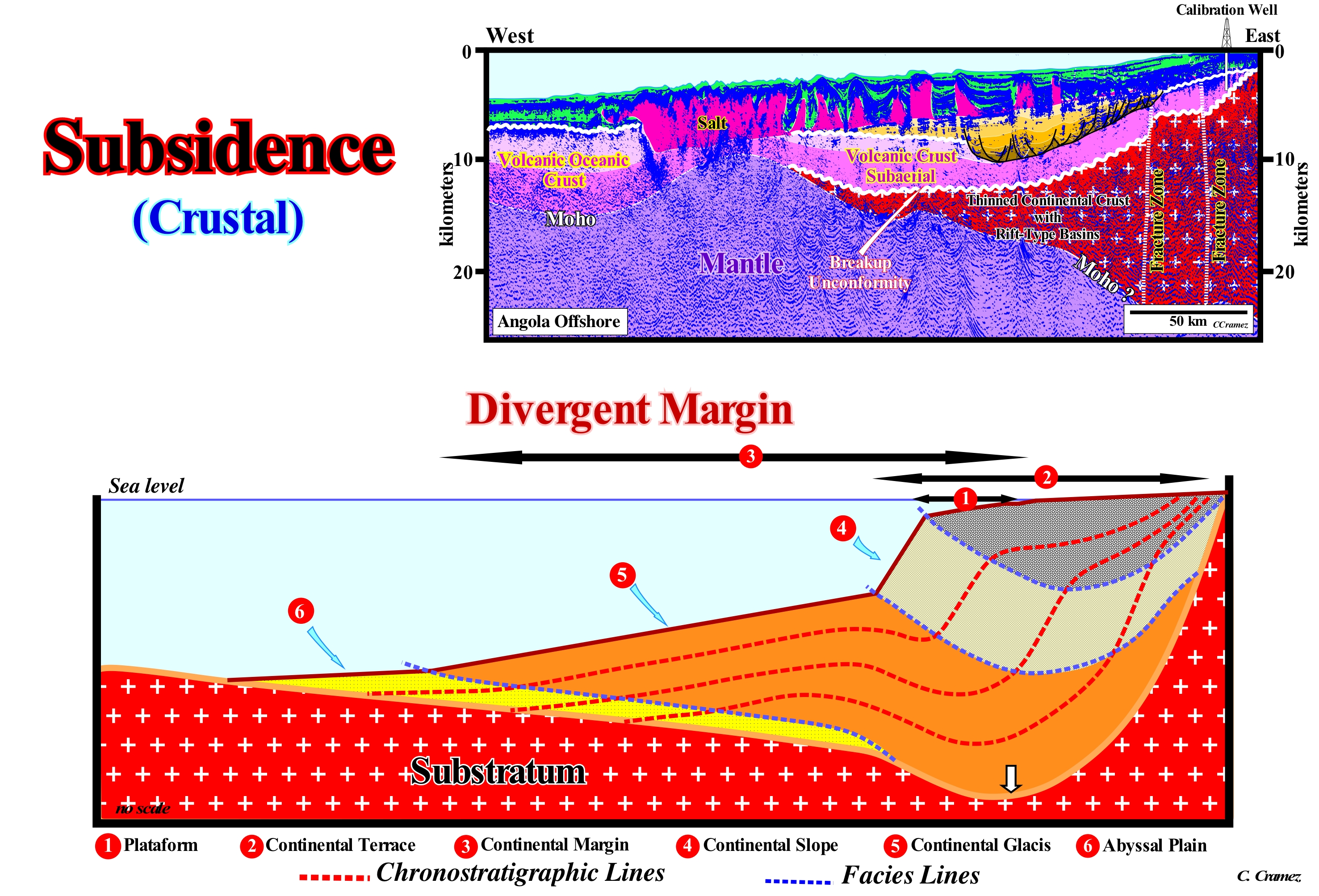
An accumulation of sediments and the formation of sedimentary basins is a function of crustal subsidence. At the beginning of the formation of a sedimentary basin, the tectonic subsidence has to be prior to sedimentation. Later, crustal subsidence is also induced by increasing sediment load (total subsidence), as illustrated in this scheme of a divergent continental margin. The tectonic subsidence is equal to the total subsidence (sediment thickness plus water-depth) decreased by the effect of isostatic compensation (due to sedimentary overload) and increased by compaction effect (chemical compaction encompasses the dissolution of minerals under pressure and compaction mechanics encompasses physical processes such as change in intergranular packing and deformation or breaking of individual grains). The tectonic subsidence of the Earth's surface or seafloor is controlled by: (i) Principle of Isostasy ; (ii) Thermal Contraction of the Lithosphere and (iii) Flexure by Loading. According to the principle of isostasy (compensation of masses and densities between the lithospheric masses and the asthenosphere), the elevation of the top of the crust is a function of the thickness and densities of the various Earth layers, which from top to bottom are: (a) Sea-water ; (b) Sediments ; (c) Solid Crust, which consists of igneous and metamorphic rocks and (d) The upper part of the Solid Mantle (lithospheric), which rests on the asthenosphere (or asthenospheric mantle, under 1350° C isotherm). Within the asthenospheric mantle (terrestrial layer that lies beneath the lithosphere, between 100 and 400 km deep, rich in iron and magnesium silicates), the horizontal surfaces are under constant pressure, i.e., everywhere, the mass per unit area of the overlying rocky column is constant: ρwhw + ρshs + ρchc + ρmhm + ρaha = constant, where h is the thickness, ρ the density, w the water layer, s the sedimentary layer, c the crust, m the lithospheric mantle and a the asthenospheric mantle. The base of the lithosphere corresponds to a temperature limit (± 1350° C). The asthenospheric mantle is less dense than the lithospheric mantle (near the interface between them). A thickening of the crust at the expense of the asthenospheric mantle causes an uplift of the Earth's surface or of the sea floor, while a thickening of the lithosphere mantle, made at the expense of the crust, creates a subsidence, that is to say, a slow sinking of a part of the Earth's crust. In basins under an extensional tectonic regime (lengthening), characterized by an elongated ellipsoid of the effective forces (σ1 vertical and σ2 and σ3 horizontal), such subsidence is created mainly by a thermal contraction (cooling) of the crust and mantle. In basins under a compressional tectonic regime (shortening), characterized by an oblong ellipsoid of the effective stresses* (σ3 vertical and σ1 and σ2 horizontal), the subsidence caused by a thickening of the lithospheric mantle, made at the expense of the crust, is, above all, induced by the bending of the lithosphere in response to sediment overloading and thrusting. For the same reason, a thick continental crust rises above the sea, while the top of the oceanic crust, more thinner, can be found several kilometers lower. In the model of a crustal subsidence induced by a sedimentary overloading, as illustrated in this figure, subsidence is a consequence of the isostasy caused by the weight of the sediments (replacement of the sea-water by sediments more denser), and the amount of subsidence depends on the density: 1) Sea-water (more or less 1,03 g/cm3) ; 2) Sediments (between 2.15 and 2.55 g/cm3) and 3) Underlying mantle (is 3.3 g/cm3). If the water-depth is filled with sediments, theoretically a certain thickness of sediment needs twice as much initial accommodation (space available for sediments). In fact, a total thickness of 14 km of sediment can be deposited near the base of the continental slope, that is, in the abyssal plain. If the lithosphere is considered as elastic, the contraction may extend about 150 km beyond the sediment loading site. However, this mechanism is not easily reconciled with the sedimentary intervals deposited under a little water-depth such as, for instance, within a sequence-cycle, upstream of the continental edge. Such a mechanism can just work if the sediments were initially deposited in deep waters. If the initial depth-water is less than 200 m, the sediment loading effect is negligible (http://www.le.ac.uk/gl/art/gl209/ lecture4 / lect4-2.html).
(*) At a given point, in depth, the ellipsoid of the effective stresses (which actually deform the sediments) is defined by the sum of the geostatic pressure (σg), hydrostatic pressure or pressure of the pores (σp) and the tectonic vector (σt).
Cryoclasty...............................................................................................................................................................................................................................Cryoclastie
Crioclastia / Crioclastía, Gelifracción / Verwitterung / 风化, 弗罗斯特楔入 / Морозное выветривание / Meteorizzazione (ciclo disgelo-congelamento) /
Erosive action due to the formation of ice. The volume of the ice is about 10% higher than the initial liquid water volume. When the water filling fault zones or fissures becomes frosted, it fractures the rock in different blocks. It is this cycle of ice and melting of the water inside a rock that is called cryoclasty.
See: « Erosion »
&
« Terrigeneous Sediment »
&
« Corrasion »
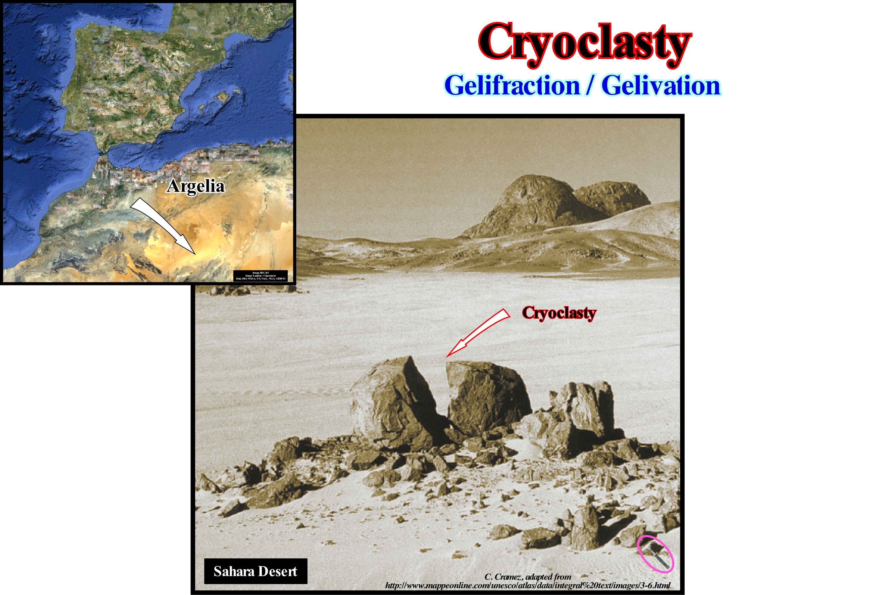
As illustrated in this figure, despite the great aridity of the soil of the Algerian Sahara, water is the main modelling agent of the landscape. In fact, haloclasty and cryoclasty are very important processes in the demolition of mountain chains. Haloclasty is the process of mechanical fragmentation of rocks due to the crystallization of salts from salt-water and salt-spray*, in which the cracks of rocks impregnated with concentrated solutions and salt minerals increase in volume by evaporation. In haloclasty the salts contained in the rocks absorb the atmospheric humidity and swell. The associated volume increasing fracture the rocks. In the cryoclasty, the moisture absorbed by the rocks freezes at night when temperatures are too low. In both cases, the increase in volume causes even the most resistant geological formations to disintegrate. It can be said that the cryoclasty (gelifraction or gelivation), as certain geoscientists call it, produces the rupture of the rocks in small blocks, more or less, lamellar function of the initial internal structure. The amplitude of the cryoclasty depends less on the intensity of the cold than on the alternation of freezing and thawing. The forms of cryoclasty are, mainly, found in the caves of altitude and in the lapiaz, as well as in the regions where there are climatic variations, more or less, important, around zero degrees Celsius. This mode of rock alteration exists, also, in the periglacial regions. The stone monuments that we find in many cities also suffer cryoclastic alterations, that without maintenance, deteriorate, or even, are destroyed. Cryoclasty appear to have shaped the Serra da Cabreira, in Portugal, where there is a morphological disparity between the western and eastern slopes. The western slope is characterized by intense gelifraction formation with large granitic slabs (macrogelifraction) with a thickness between 1 and 2 cm, some of which are more than 1 m in length (they can be seen in the flat tops of Talefe-Chã de Lousas and Toco).
(*) A foam cloud formed by droplets of sea-water and bubbles enclosing saline micro-crystals resulting from the surfing foam that is projected against the shore and carried inward by the wind.
Cryptic Unconformity.......................................................................................................................................Discordance cryptique
Discordância Críptica / Discordancia críptica / Schräg-Diskordanz / 角度不整合 / Скрытое несогласие / Discordanza angolare /
Unconformity that is not, at least locally, tectonically enhanced (angular unconformity) and difficult to recognize. This type of unconformity is very common in basins, in which extensional tectonic regimes are predominant. At the level of sequence-cycles, this is particularly true landward of the basin edge and in deep-water. On the seismic lines, the great majority of the unconformities are cryptic. The erosion, that characterizes them, is difficult to put in evidence. Landward of the basin edge just the incised valley fills, clearly, highlight the erosional surface, which accompanies the relative sea level fall, that characterise the unconformity. Seaward of the basin edge, the submarine canyon and valley fills are geological peculiarities that allow, also, the identification of unconformities, but not their correlative deep-water paraconformities.
See: « Sequence-Cycle »
&
« Truncation »
&
« Unconformity »
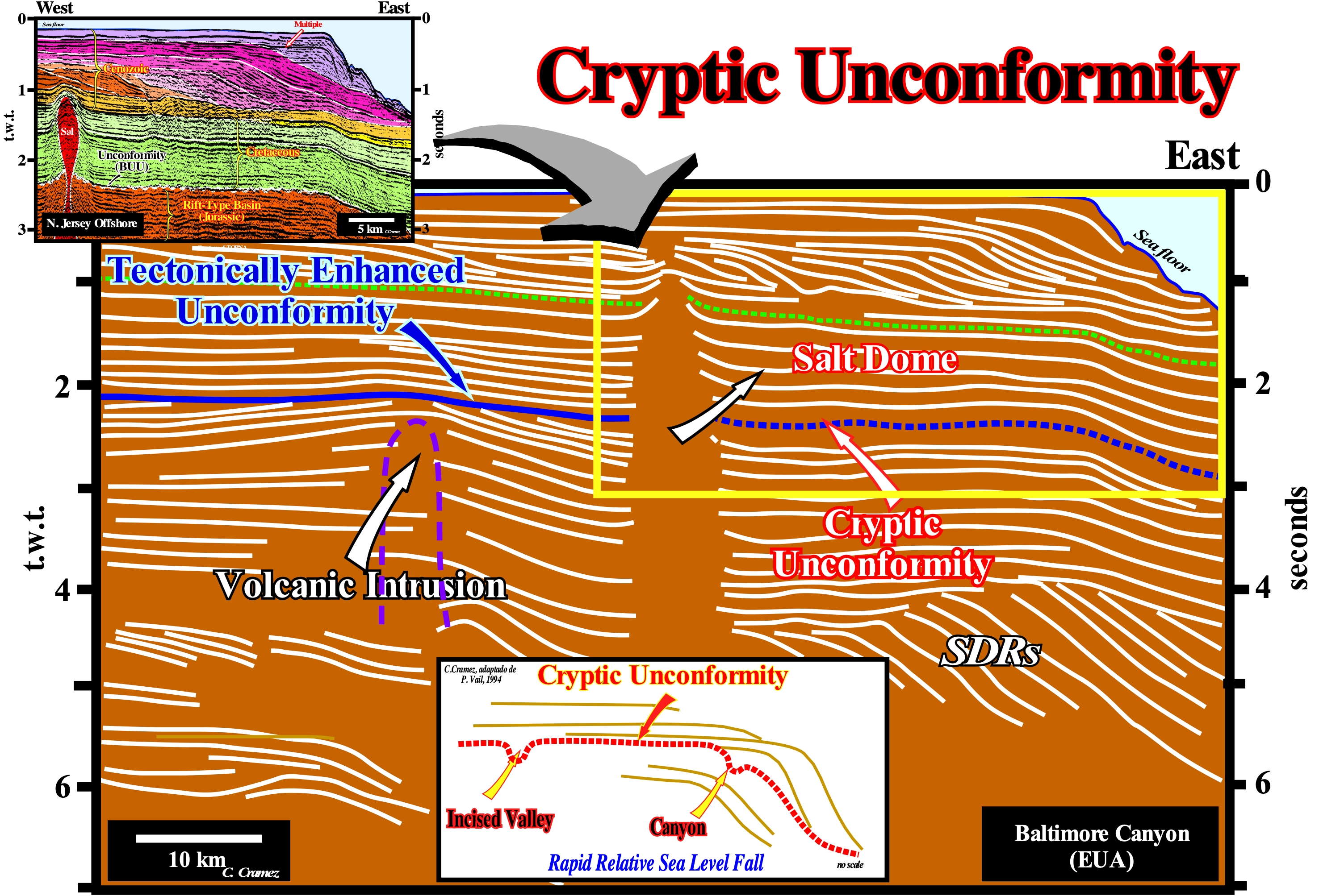
All non tectonically enhanced unconformities, i.e., all non angular unconformities are cryptic (difficult to identify). They are difficult to recognize and especially to follow (picking) both on seismic lines and on the field. This is particularly true in the absence of incised valley and submarine canyons fills, as illustrated in the geological model on the lower part of this figure, where the anomalies associated with the submarine canyon and the incised valley are obvious. In the same way, this is, perfectly, corroborated on this tentative geological interpretation of a Canvas auto-trace of a regional seismic line of the New Jersey offshore (Baltimore Cannon, United States). In the western part of this auto-trace, a volcanic intrusion (confirmed by oil exploration wells and magnetics studies), which is quite visible in the parallel lines, deformed the overlying sediments creating an antiform structure (extensional and not compressional structure such as an anticline). Later, the antiform structure was, partially, eroded following a significant fall of the relative sea level (sea level, local, referenced to any point on the Earth's surface, which could be the sea-floor or the base of the sediments and which is the result of the combined action of absolute or eustatic sea level, which is the global sea level, referenced to the Earth's centre, and tectonics), which exhumed the continental platform (shelf) and created an erosional surface, i.e., a regional unconformity, that underlies the top of the Triassic. Regionally, the unconformity associated with this relative sea level fall is cryptic, as can be seen in the eastern part of this tentative interpretation (an area where sediments were not deformed by the implementation of the volcanic intrusion). In the middle of the auto-trace, the reflector terminations emphasize a salt dome. It is interesting to note that, just, the sediments of the progradational interval were, partially, deformed by the upward movement of the salt dome. This, probably, means the salt dome struck the sea floor very early, and that as the sediments deposited it rises without deforming them, until it has been, totally, fossilized by the progradational upper sediments of the Cenozoic. Later, the upward movement of the salt dome, probably, resumed by halokinesis, deforming the overlying sediments (lengthening them). However, as the strata did not reach the sea floor, there was no significant erosion of the sediments. This means that tectonics deforms sediments, but by itself can not erode them. For erosion to occur it is necessary that there is a significant relative sea level fall that exposes sediments to erosional agents. Another possible explanation for the lack of deformation of the sediments surrounding the salt structure is to admit that this structure does not correspond to a salt dome but to a salt drop structure, disconnected from the autochthonous salt mother-rock by a vertical salt weld (detached salt stock). In this way, the absence of deformation of the reflectors is apparent. Under the salt mass forming the drop structure no seismic reflector can be highlighted. This hypothesis is more difficult to refute than the first one. On a seismic line, a salt dome with vertical walls, i.e., a cylindrical shaped salt dome is a physical impossibility: (i) Salt density is constant in depth what is not the case of the surrounding sediments, whose density increases with depth ; (ii) In depth, along a salt dome, there is a point of density inversion between the salt and the adjacent sediments, above which the salt density is greater than the density of the sediments ; (iii) On this auto-trace, a salt dome of 4 seconds thick (t.w.t.) would imply a depth of base of the salt much greater than the thickness of all sedimentary intervals (seismic wave velocity within the salt is about 4,000-5,000 m/s, which is much higher than the velocity of the seismic waves within clastic sedimentary rock). The seismic line of this tentative interpretation and in particular the progradational interval (Cenozoic), i.e., the seismic interval between the sea floor and about 1-1.5 seconds (t.w.t.) is used in the courses of sequential stratigraphy to show the importance and, above all the preponderance, of eustasy (absolute sea level changes) in the stratigraphy. Indeed, on this tentative, the subsidence induced by tectonics was, throughout the Cenozoic, insignificant. Almost the available space for the sediments (accommodation) was created by eustasy. All segments, landward of the depositional coastal break of the different chronostratigraphic lines are sub-horizontal.
Cryosphere.........................................................................................................................................................................................................................Cryosphère
Criosfera / Criósfera / Kryosphäre / 冰冻圈 / Криосфера (ледовый покров земли) / Criosfera /
Part of the Earth's surface that is frozen permanently.
See: « Glaciation »
&
« Glacio-Eustasy »
&
« Astronomic Theory of Paleoclimate »
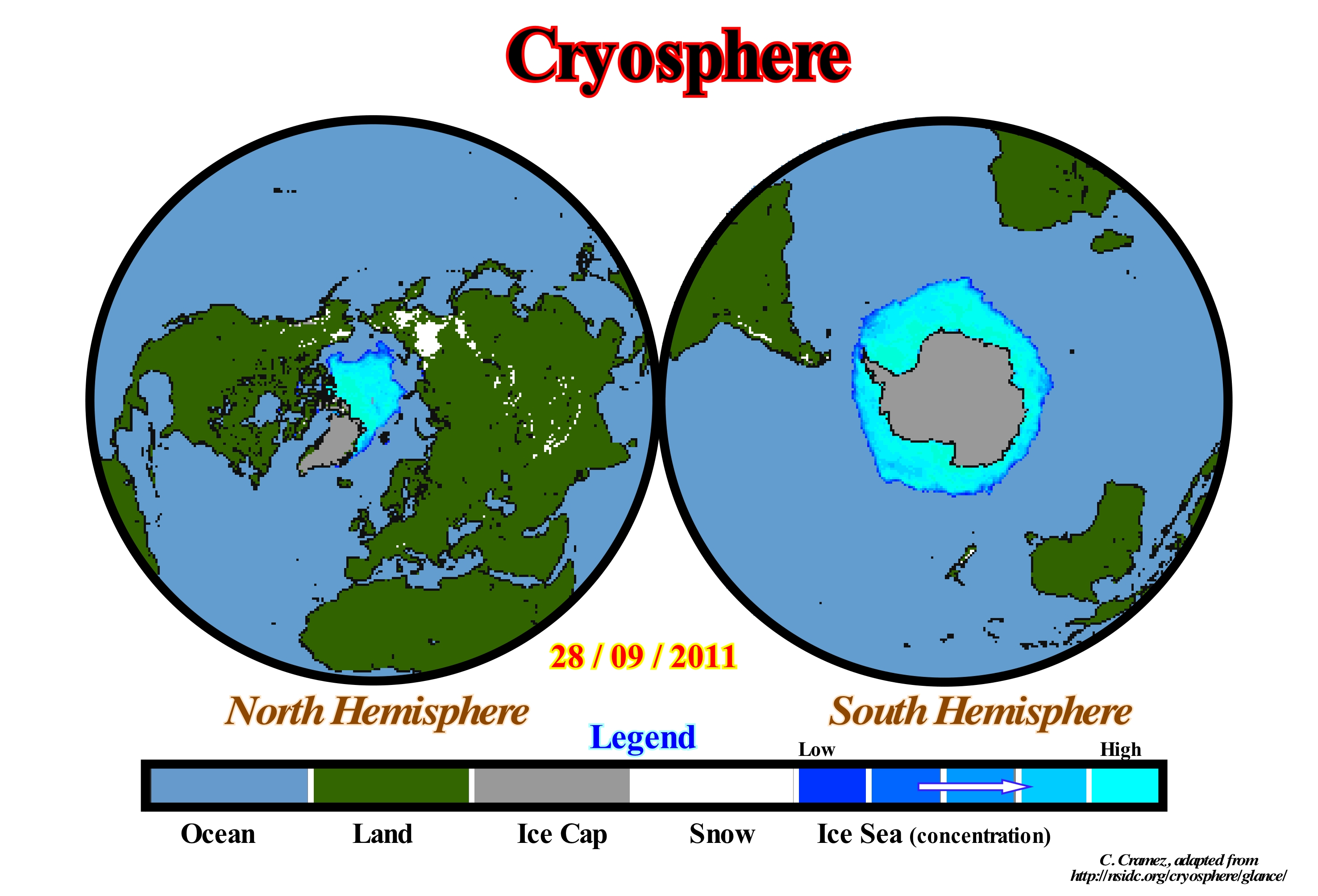
For some geoscientists, the cryosphere is that part of the Earth that is, permanently, covered with ice and interacts with the other components, particularly, the atmosphere, hydrosphere and lithosphere. Climate change, significantly, affect the dimensions of the cryosphere. Temperature variations can result in the accumulation of thousands of square kilometers of snow or ice. These accumulations affect not only air temperature, but sea level, ocean currents and storms as well. Snow and ice help the Earth to cool since they reflect between 60% and 90% of the solar energy they receive. Snow and ice increase the albedo of the Earth's surface, i.e., the amount of reflectivity, which varies between 0 and 1 (0 indicates a zero reflectivity, meaning that all solar energy is absorbed and 1 indicates a perfect reflectivity, which means that all the energy received by the Earth is reflected). A significant reduction of the surface covered by snow or ice causes an increase in temperature, since more solar energy is received. Climatic models, which should always be considered as pure conjectures ("purgamentorum init purgamentorum exit"), suggest global warming (if it exists) should be felt more in the Arctic zones, where it seems that geoscientists already observe several climate change (not anthropogenic). The study of the cryosphere allows geoscientists to advance hypotheses about climate changes from the geological past, just as the climate is changing at present. Ice from the polar ice cores contains information that can be used to understand the climate of the past, at the condition that they are well used, and the results subjected to refutation tests, which in some cases have not been done by the IPCC (" Intergovernmental Panel on Climate Change "). The ice formed in the lakes and rivers, due to the cooling caused by the seasons, is too small to exert any influence on the global climate. Ice and thaw processes, even in these cases, are responses to global climatic factors that have existed since Earth's formation and not just since the Quaternary.
Cryptozoic........................................................................................................................................................................................................................Criptozoïque
Criptozóico / Criptozóico / Cryptozoic / 隐生宙[的] / Докембрий/ Criptozoico /
Time between the formation of the solar system (end of the Gamowian ± 4.7 109 years ago) to the beginning of the Cambrian (570 Ma). The Cryptozoic is divided into three eons (hierarchy superior to the era): (i) Hadean, between 4.7 and 3.8 Ga ; (ii) Archaean between 3.8 and 2.7 Ga and (iii) Proterozoic between 2.7 and 0.57 Ga.
See: « Cosmological Time »
&
« Universe (age) »
&
« Geological Time »
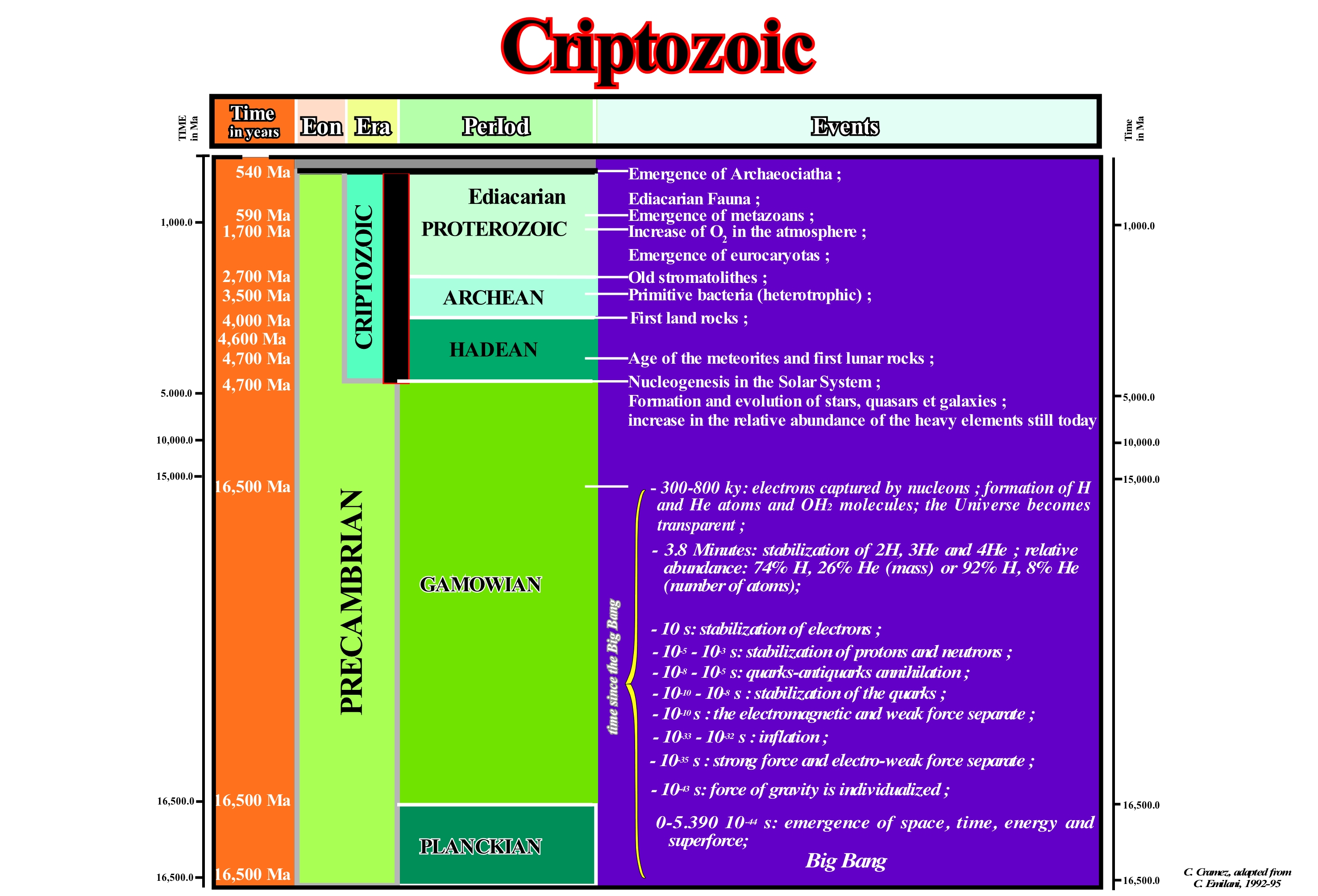
The Cryptozoic encompasses all time between the formation of the solar system, that is to say, from the end of the Gamowian (4.7 x 10⁹ years ago or 4.7 Ga) to the beginning of the Cambrian, i.e., up to about 570 Ma. Contrariwise to 10 My, which underlines a time interval of 10 million years, whether it be from the Cretaceous or from the Devonian, 10 Ma represents an age. Thus 65 Ma means a geological age of 65 million years. The Cryptozoic, as illustrated in this figure was divided into three Eons (a rank higher than the Age): (i) Hadean ; (ii) Archean and (iii) Proterozoic. The Cryptozoic is also called Precambrian, more strictly, speaking. The Precambrian includes all the time before the Cambrian, that is to say, the Gamowian and the Planckian. The Hadean (between 4.7 and 3.8 Ga), embraces the formation and differentiation of the Earth, as well as, the evolution of bacteria. The Archean (between 3.8 and 2.7 Ga) is the time of the formation of the stromatolithic crust and dome-shaped stromatolites. The Early Proterozoic (between 2.7 and 1.7 Ga) is the time of cylindrical stromatolites. The Late Proterozoic (between 1.7 and 0.54 Ga) is the time of the branched stromatolites, the evolution of eukaryotes and the appearance of Ediacara fauna. The Phanerozoic (between 540 Ma and Today) is the time of the appearance of Archaeocyatha, and development of metazoans and metaphythes. Metazoans form the sub-kingdom which includes all species of multicellular animals characterized by digestive system and differentiated cells in various tissues only animals that are not considered metazoans comprise the three phyla of uncertain systematic position: Rhombozoa, Orthonectida and Placozoa, which are, sometimes, grouped in the sub-kingdom Agnotozoa (meaning "unknown animals"). The metaphythes constitute the plant kingdom and include all the multicellular eukaryotes, photosynthetic plants found in this biosphere, which are composed of three large groups: (i) Algae, (ii) Bryophytes and (iii) Tracheophytes.
Cuesta...............................................................................................................................................................................................................................................................Cuesta
Cuesta / Cuesta / Abhang / 坡 / наклон / Cuesta /
Asymmetrical ridge with one side slightly sloping and conform to the underlying strata and the other side with a greater slope due mainly to the resistance of the strata. Generally, cuesta is a ridge where a harder sedimentary rock overlies a softer layer, the whole being tilted somewhat from the horizontal.
See: « Strata »
&
« Erosion »
&
« SDR (reflector dipping seaward) »
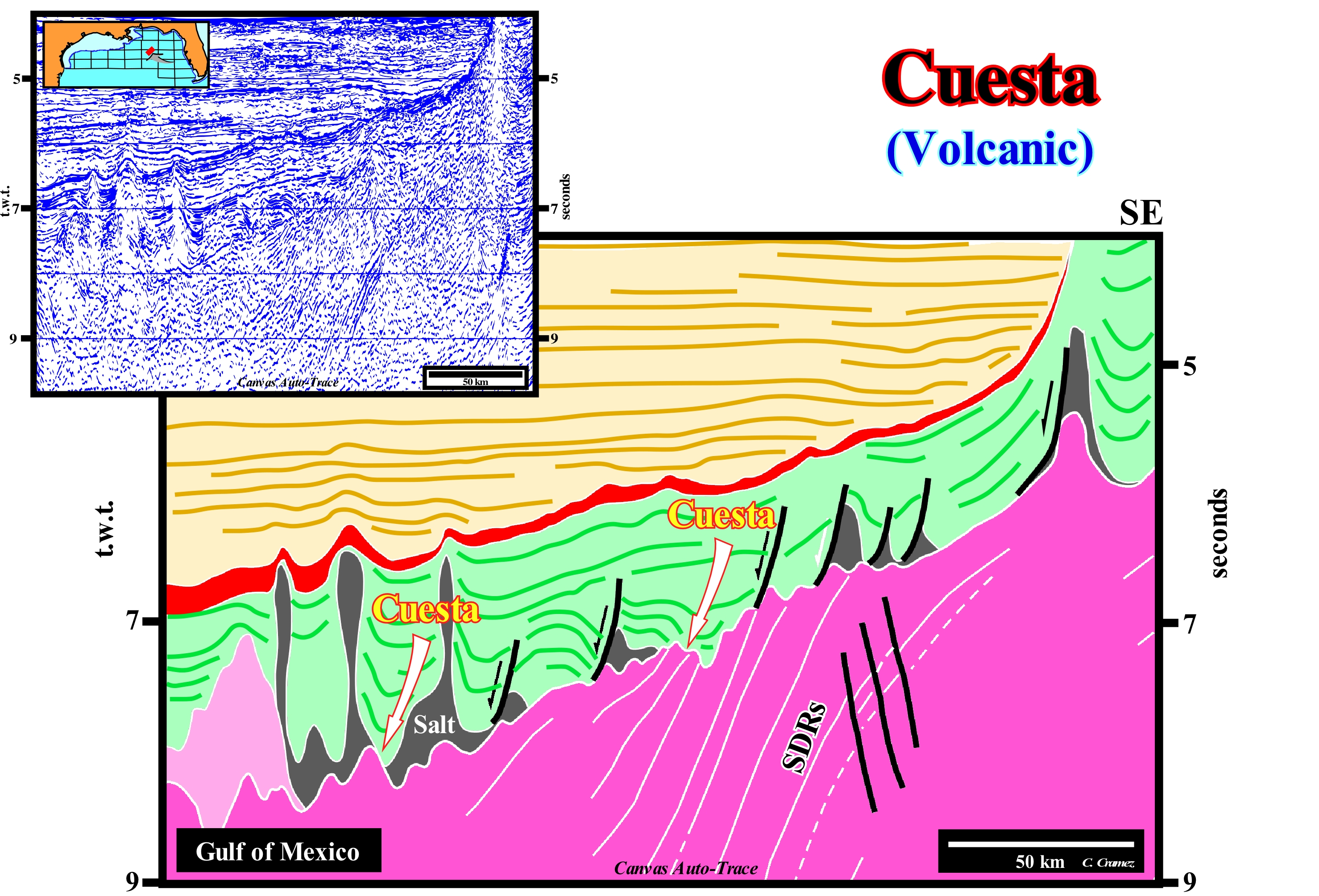
On this tentative geological interpretation of a Canvas auto-trace of a seismic line of the Gulf of Mexico, the proposed cuestas at the base of the saliferous horizon and, especially, in the salt welds (when the salt disappears completely by flow or when it has a thickness inferior to the seismic resolution) are volcanic cuestas associated with lava deltas. The Atlantic-type divergent continental margins are, essentially, volcanic divergent margins. The sedimentary prisms lie, directly, on a substratum formed, mainly, by sub-aerial lavas. The dimensions of such a substrate are impressive. In fact, the sub-aerial lavas, which dip seaward and thinning continentward (SDRs, i.e., Seaward Dipping Reflectors), such as those illustrated in this tentative, may be followed since Northern Europe and North America offshore till the offshores of South Africa, Brazil and Argentina. The total thickness of the lavas, which overlap, partially, is variable, but may exceed ten kilometers. The sub-aerial lavas flow from the sub-aerial expansion centres towards the continent (volcanoes, more or less, rectilinear, formed when the lithosphere break-up). Not only do they pinchout toward continentward and they are post break-up unconformity, which separates the rift-type basins from the overlying margin sediments. The sub-aerial volcanic substratum is an integral part of the divergent margins. If there is no obstacle to the flow, the lava thin continentward and disappear progressively. If there is a barrier to the lava flowing, such as a lake or epicontinental sea, the lava entering the water cool, rapidly, and solidify into lava deltas, i.e., sigmoid progradational constructions (upbuilding and outbuilding) in direction of flow, similar to the progradations of a delta building. It is these structures that form the volcanic cuestas proposed on this tentative interpretation. This type of lava and lava delta were recognized by several oil exploration wells and DSDP in the Atlantic offshore.
Curie's Point (Curie temperature)...................................................................................................Point de Curie (Temperatura de Curie)
Ponto de Curie / Punto de Curie / Curie-Temperatur / 居里点 / Точка Кюри (температура фазового перехода второго рода) / Punto di Curie /
Temperature above which a ferromagnetic (attracted by a magnet) or piezoelectric material (which can create an electric field) becomes paramagnetic. Synonym of Curie Temperature.
See: « Magnetics »
&
« Magnetostratigraphy »
&
« Magnetic Polarity »
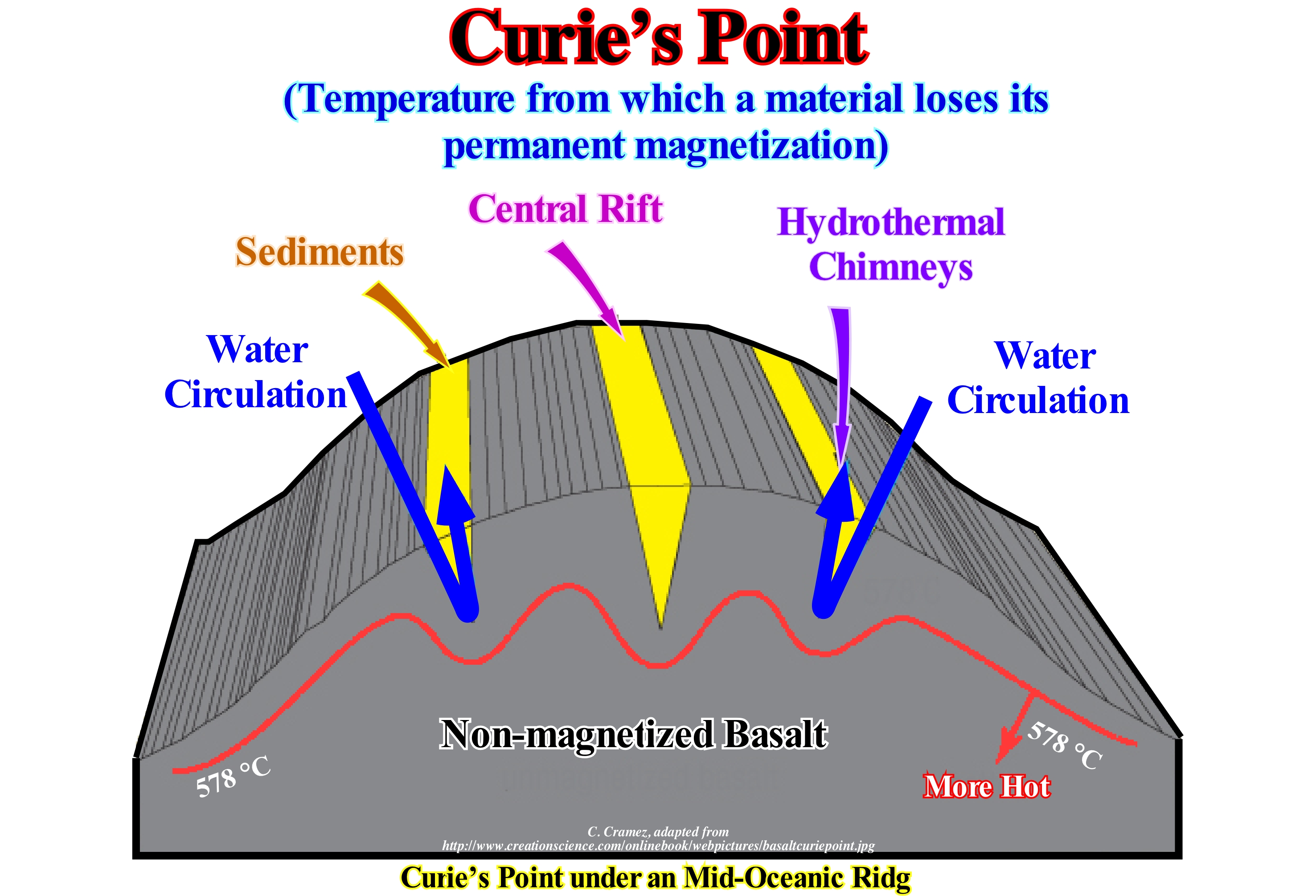
A magnet, when heated, loses its magnetic properties, since heat causes a break-down in the arrangement of its particles. Above a certain temperature. the conductors lose their magnetic properties. This temperature, which is constant for each substance, is called Curie's temperature or Curie's point. At this temperature the materials lose their ferromagnetic properties. This transition is reversible through the cooling of the material. As examples of Curie's temperature we can mention 770° C for iron, 1075° C for cobalt, 365° C for nickel, etc. Unlike a ferromagnetic material, a paramagnetic, which is attracted by a magnetic field, does not retain magnetization in the absence of an external magnetic field. Below the Curie's temperature, magnetic moments are aligned in parallel within magnetic domains in ferromagnetic materials and anti-parallel in ferromagnetic materials (magnetic moments of the atoms have an opposite direction). Above the Curie's point, a ferromagnetic material becomes paramagnetic and thus the magnetic moments are in a total disorder. This figure shows a typical geological section of a mid-oceanic ridge. The ridge temperature, usually, increases with depth. However, the walls of fractures in a mid-oceanic ridge are, usually, cooled by the cold water circulating down and out of them by natural convection. After several thousand years of cooling, a temperature line corresponding to the Curie's point forms, perpendicularly, the ridge (dorsal), as shown in this sketch (red line). When a rock particle cools, for example, from 579 ° C to 577 ° C, it takes the magnetism of the Earth's magnetic field at that point, which implies that the most magnetized material must be close to the fractures, whereas the material above Curie's temperature is not magnetized. They form magnetic anomalies, perpendicularly, to the ridge along fracture zones, as the ocean floor is expanded.
Current Ripple-Mark...............................................................................................................................................................Ride de courant
Marca de ondulação / Marca de ondulación de corriente / Stromwelligkeit Marke / 纹波电流标志 / Рябь, созданная течением воды / Increspature di fondo (corrente) /
Asymmetric ripple-mark formed by wind or water, with the most inclined face oriented in the predominant direction of current flow.
See: « Sedimentation »
&
« Swash Mark »
&
« Oscillatory Ripples »
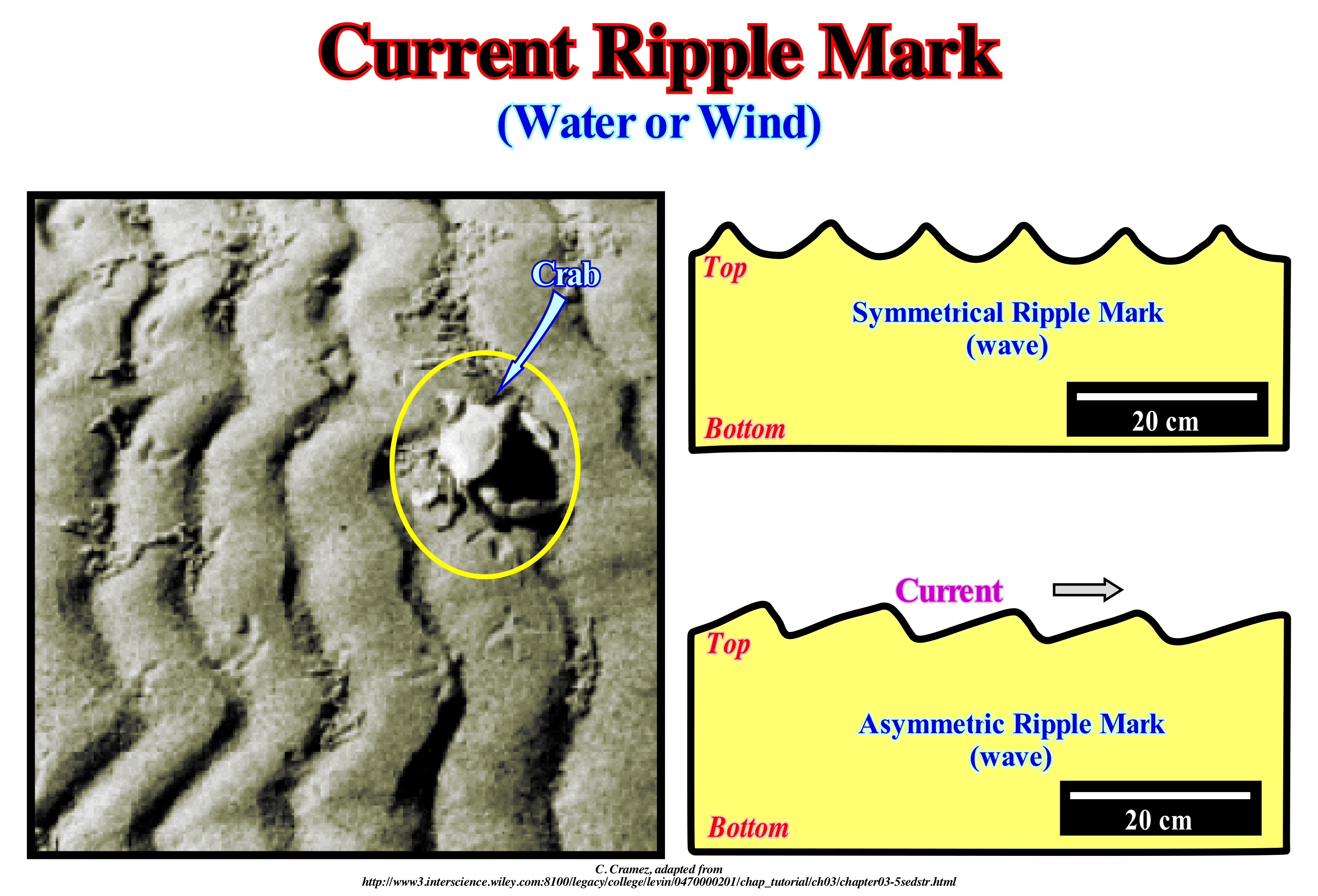
The current marks are wavy surfaces formed by an alternation of small crests and depressions created at the interface between a fluid and an inconsistent sedimentary material. They can be produced by the action of wind, action of submarine currents or wave agitation. They may be oriented perpendicularly or obliquely to the flow direction. They are distinguished, easily, from wave-induced symmetrical ripple-marks. Although, in certain cases, the waves may induce asymmetrical ripple-marks. The ripple-marks are induced by currents and the asymmetric ripple-marks induced by waves are, in both cases, formed at the base of a shallow water-body and are, often, preserved in certain sedimentary rocks. Since they can give very important information about the deposit conditions, it is important to know the characteristics by which they are distinguished from each other. The main differences can be summarized as follows: (i) Along the longitudinal axis, the axes of the ripple-marks formed by the oscillating waves are rectilinear or, when curved, the curves are long and uniform and the axes, more or less, parallel ; in the ripple-marks formed by the currents, the longitudinal axes are not parallel and each mark is curved and irregular ; (ii) At the top and bottom angles, the wave induced asymmetrical ripple-marks are rounded at the top and bottom, while those induced by the currents are, often, angular if the current is, sufficiently, fast to cause a steady flow of sand grains ; (iii) There is little difference in the height of the crests along the ripple-marks, induced by the waves, but in the marks induced by the currents the height is irregular ; (iv) Regarding their form, the waves induce crests in flat sediments, where there are practically no troughs, while currents sweep the surfaces of the sediments, and thus the troughs and crest have a similar development. These waves are of oscillation waves* (orbital movement of water) and not of translation waves (when the water moves to the continent).
(*) Before the breaking, the movement of the water is circular (forward and upward when a crest passes, and down and back in the passage of a trough) and the waves are oscillating. After the breaking, the water, previously, on the crest flows through the front face and continues to cross the surf zone forming translation waves.
Cuspate Delta (Blunt delta).......................................................................................................................Delta en croissant (Delta obtus)
Delta em crescentes / Delta en media-luna / Stumpfdelta / 尖头三角洲 / Фестончатая (невыдвинутая) дельта / Delta mezzaluna (delta ottuso) /
When the delta plain, due to the erosive action of the sea-waves (or of a lake), has a concave geometry towards the side of the water.
See: « Delta »
&
« Delta Front »
&
« Major Storm Wave Base »
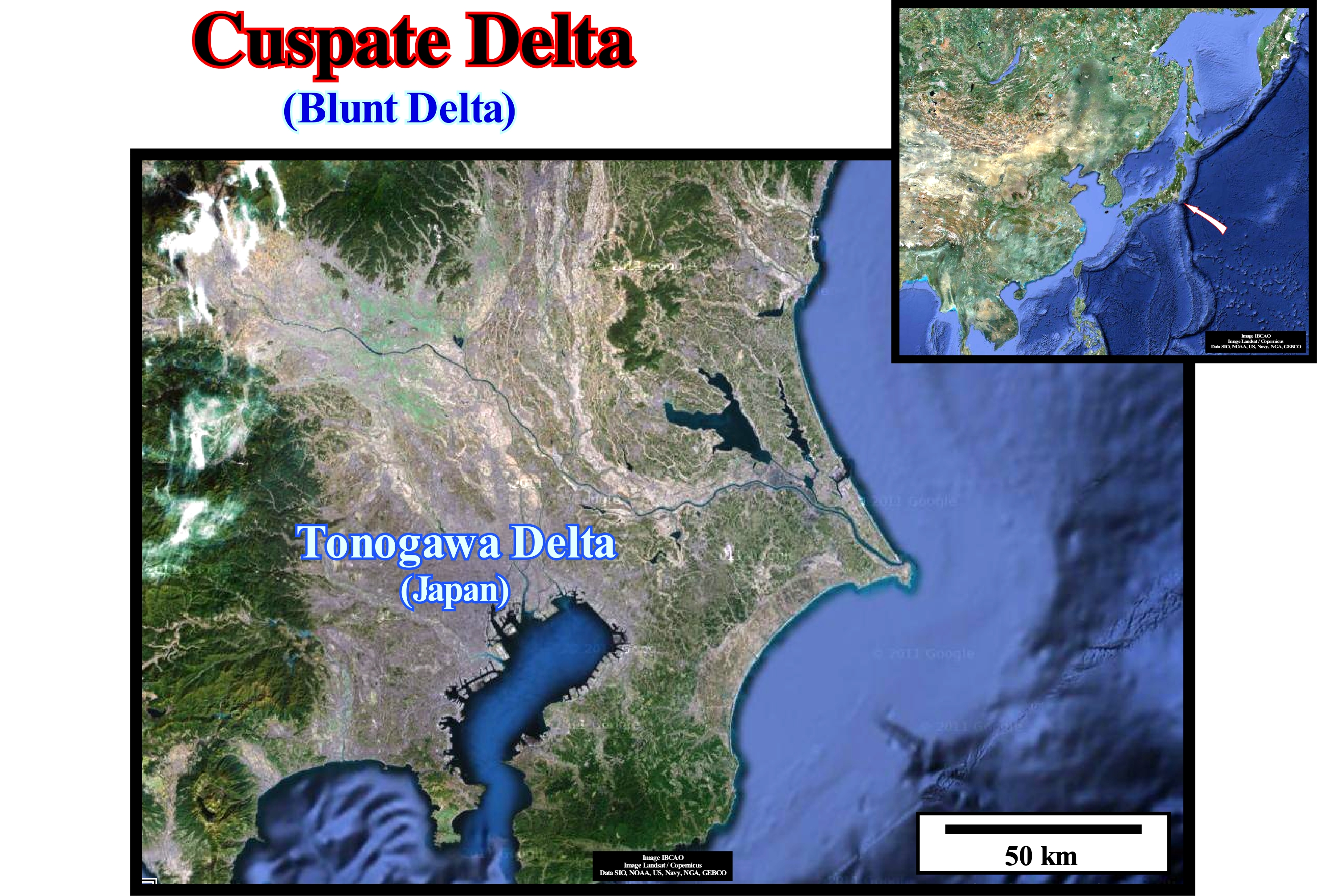
A cuspate delta is the delta that forms when a river drains into a coastline, more or less, straight and subject to a strong swell, in such a way that sea-waves force the sedimentary particles to spread in two directions opposite the river-mouth, building an arrowhead with crescent-shaped curves on each side. A cuspate delta can not be confused with an arcuate delta. An arcuate delta forms when a river meets the sea in a place where the waves, currents and tides are strong, in the areas where the longitudinal currents maintains the edge of the delta trimmed and relatively smooth. In other words, these deltas are dominated by sea-waves and are the erosion induced by the waves that controls the shape of the delta. The vast majority of the sedimentary particles arriving from the mouth are diverted along the coastline. However, these deltas can have multiple energies. When the delta is tilted and with high energy, the coasts with deficient sedimentary particles have little sand at the bottom and a, relatively, deep offshore. When the delta is little inclined in a low energy environment, the coasts are, usually, shaly with a coastal vegetation fringe. In these deltas, the action of the incident waves is dissipated in a shallow-water offshore, which is not the case for most deltas. In general, deltas result from river and sea processes, and the sedimentary particles transported by rivers are deposited when the stream enters a water-body without strong currents, such as a lake, lagoon, sea or ocean. The deposition of the sedimentary particles is enhanced when the water is salted. The finer particles, and especially the shaly ones, agglutinate in the salt water, forming larger particles. Other major factors that influence deposition are: (i) Type of sedimentary particles ; (ii) Local geological context; (iii) Eustatic changes (absolute sea level, which is supposed to be global and referenced to the Earth's centre) and changes of relative sea level (local sea level referenced to any point on the Earth's surface, and which is the result of the combined action of absolute sea level and tectonics) ; (v) Plant growth; (vi) Human Impact, etc. Typical examples of large delta buildings are associated with the Mississippi, Ganges, Bramaputra, Rhone, Rhine, Dust, Danube, Nile rivers. The actual Ebro Delta in Spain, San Francisco Delta (between Sergipe and Alagoas in Brazil) and the Tonogawa Delta in Japan, are typical cuspate deltas. The Tonogowa delta, for instance, illustrated in this figure, is a cuspate our blunt delta (arrowhead delta), which forms when a river deposits the sedimentary particles, which it transports on a, more or less, straight-line coastline, but dominated by very strong waves that oblige the sedimentary particles to spread, perpendicularly, to the mouth of the river and in opposite directions. Another well-known cuspate delta is the actual Tiber delta (Italy). The Tiber deelta building began to form between 13,000 and 7,000 years BC, when the fluvial valley and deep (incised valley), which the river dug during the Wurm glaciation(*) (characterized by having produced a significant absolute or eustatic sea level fall, at least in the Northern Hemisphere), was, partially, inundated by the increments of the absolute sea level rise induced by thawing. Initially, during the marine ingression, the delta building was of in the bottom of the bay and its geometry, globally, retrogradational. Around 8,000 BC, the delta building began to progradate seaward (sedimentary regression) and changed (around 6,000 BC) into a cuspate delta due, mainly, to the action of the waves. The interaction between sea level rise induced by the melting of ice caps, terrigeneous transport and wave energy, explains the evolution of the Tiber region over the last 18,000 years. Several types of delta can be considered as a function of the dynamics of the delta and the shape of the emergent plain: (i) Abandoned delta (sub-delta) ; (ii) Alluvial delta; (iii) Arctic Delta; (iv) Rounded Delta; (v) Atrophied Delta; (vi) Complex or polymorphic Delta; (vii) Typed Delta; (viii) Flood delta; (ix) Closed Delta; (x) Gilbert-type Delta; (xi) Lava Delta; (xii) Lobated Delta ; (xiii) Tidal delta; (xiv) Sunmarine Delta; (xv) Storm Delta; (xvi) Wave Delta ; (xvii) Ebb Delta.
(*) The last glacial period, also known as Ice Age, Wisconsin Glaciation, Würm Glaciation, Wurmian or Laurentian, is the designation given to the last episode of Earth's glaciation recorded during the present geological age. It took place during the last part of the Pleistocene, between 110 k and 10 ky before the Present and is the best known of recent glaciations. This cold period was followed by another warming that continues today and during which the glaciers are thinning. However, even in the Holocene there were variations in temperature and ice thickness, as suggested by the Little Ice Age between the 13th and 19th centuries. The Holocene is considered by most geoscientists to have a inter-glacial period within a large glacial age, since the poles and highlands of the mountain are still covered with ice. However, it can be said since the end of the Little Ice Age, dating back almost 150 years, the thinning of the glaciers is almost continuous. They have lost about a third of their total volume, which means the average thickness has decreased by 30 cm/year over this period.
Cyanobacteria..................................................................................................................................................................................................Cyanobactérie
Cianobactéria / Cyanobacteria / Cyanobakterien / 藍菌 / Цианобактерии / Cyanobacteria /
Phylum of bacteria that gets its energy through photosynthesis. Cyanobacteria are an important component of the marine nitrogen cycle and, in many areas of the ocean, they are a major primary producer. They are, also, found in environments other than marine. Synonym of Green Blue Algae.
See: « Algae »
&
« Photosynthesis »
&
« Brown Algae (Phaeophyceae) »
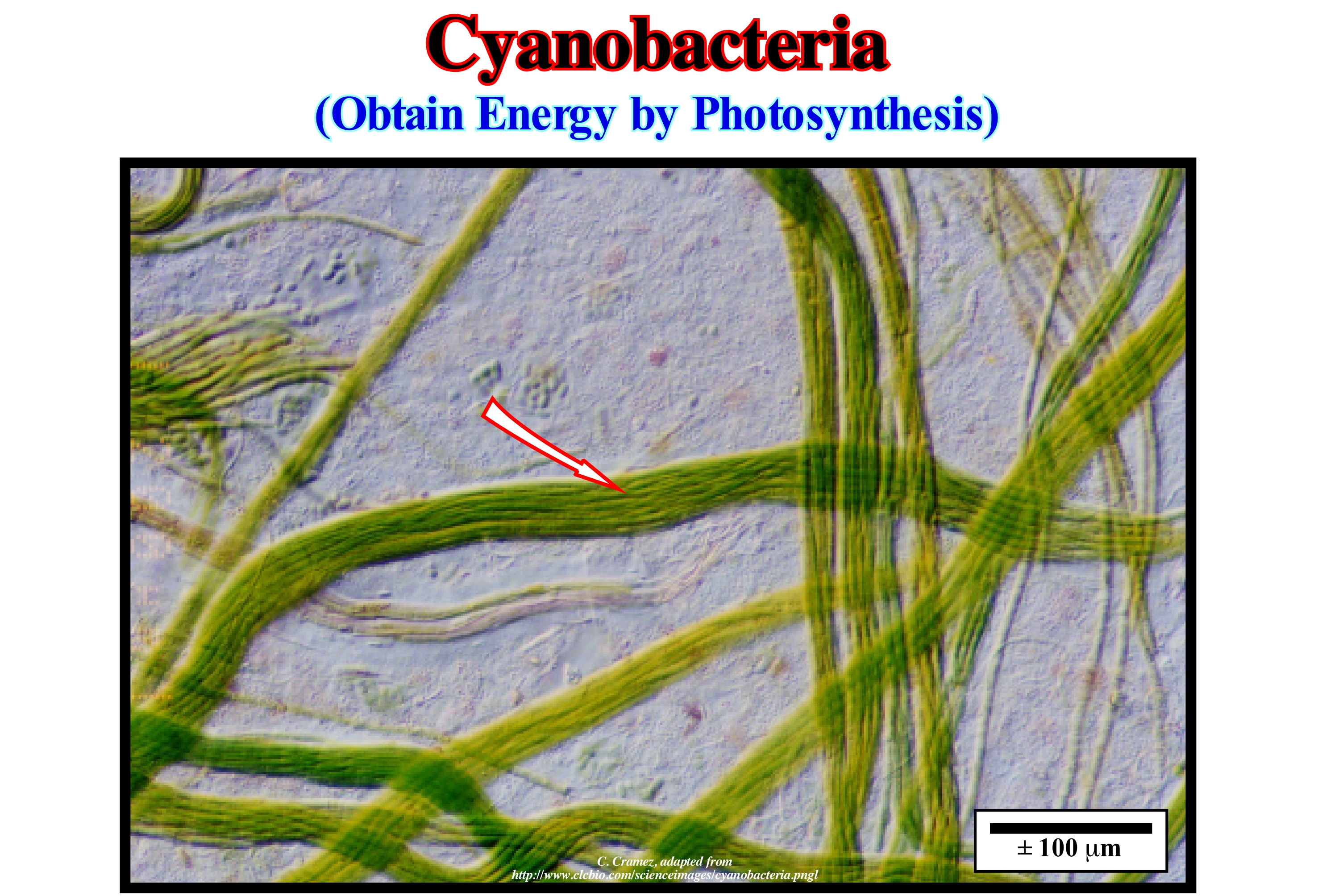
Cyanobacteria are larger than the other prokaryotes. They do not have locomotive organs and perform the photosynthesis with the aid of varied pigments: (i) Chlorophyll a ; (ii) Carotenoids (yellow pigments) ; (iii) Anthocyanins (blue pigment) and (iv) Phycoerythrin (red pigment). Unlike photosynthesis of bacteria, the photosynthesis of cyanobacteria is done without oxygen. It can be summed by the equation: 6CO2 + 6H2O + energy ↔ C6H12O6 + 6O2 ± 7,1 eV. The reaction is done from left to right during photosynthesis and from right to left during respiration, which here means bio-oxidation of the reduced organic substances and not inhalation. It is for this reason that when I was a child my mother would remove the flower pots from my bedroom during the night, so that the plants would not use the oxygen I should breath. Cyanobacteria have a free life, but may establish symbiosis with other organisms or form filamentous colonies, sometimes, surrounded by a mucilaginous capsule. These pigments distinguish them from the other photosynthetic bacteria because they depend on bacteriochlorophyll (it does photosynthesis but does not produce oxygen using wave-lengths of light that are not absorbed by plants) to perform this important process. Another important difference is that cyanobacteria have internal lamellae, invaginations of the plasma membrane, where pigments and photosynthetic enzymes* are located. These lamellae are considered precursors of plant thylakoids and do not exist in the remaining photosynthetic bacteria. As in the cyanobacteria illustrated in this figure ("Microcoleus chthonoplastes"), most of the primary productivity occurs via oxygenated photosynthesis of cyanobacteria and diatoms, where carbon is fixed by the Calvin cycle (series of biochemical reactions occurring in the stroma, which form the colloidal matrix of chloroplasts of photosynthetic organisms). Chloroplasts are organelles that have a double membrane, where the pigments involved in photosynthesis are found.
(*) Groups of organic substances of a normally protein nature with intra- or extracellular activity that have catalytic functions, catalysing chemical reactions that, without their presence, would hardly occur. This is achieved by lowering the activation energy required for a chemical reaction, resulting in increased reaction velocity and enabling the metabolism of living beings. (https://en.wikipedia.org/wiki/Enzima)
Cycle..............................................................................................................................................................................................................................................................................Cycle
Ciclo / Ciclo / Zyklus / 周期 / Цикл / Ciclo /
Succession of geological phenomena or others, systematically, reproduced at regular periods. Occurrence of events that are repeated, usually, in a particular order, such as sea level changes (relative or absolute), formation of supercontinents, climatic changes, glaciations, seasons, moon phases, tides, etc.
See: « Relative Sea Level Change »
&
« Supercontinent »
&
« Milankovitch Cycle »
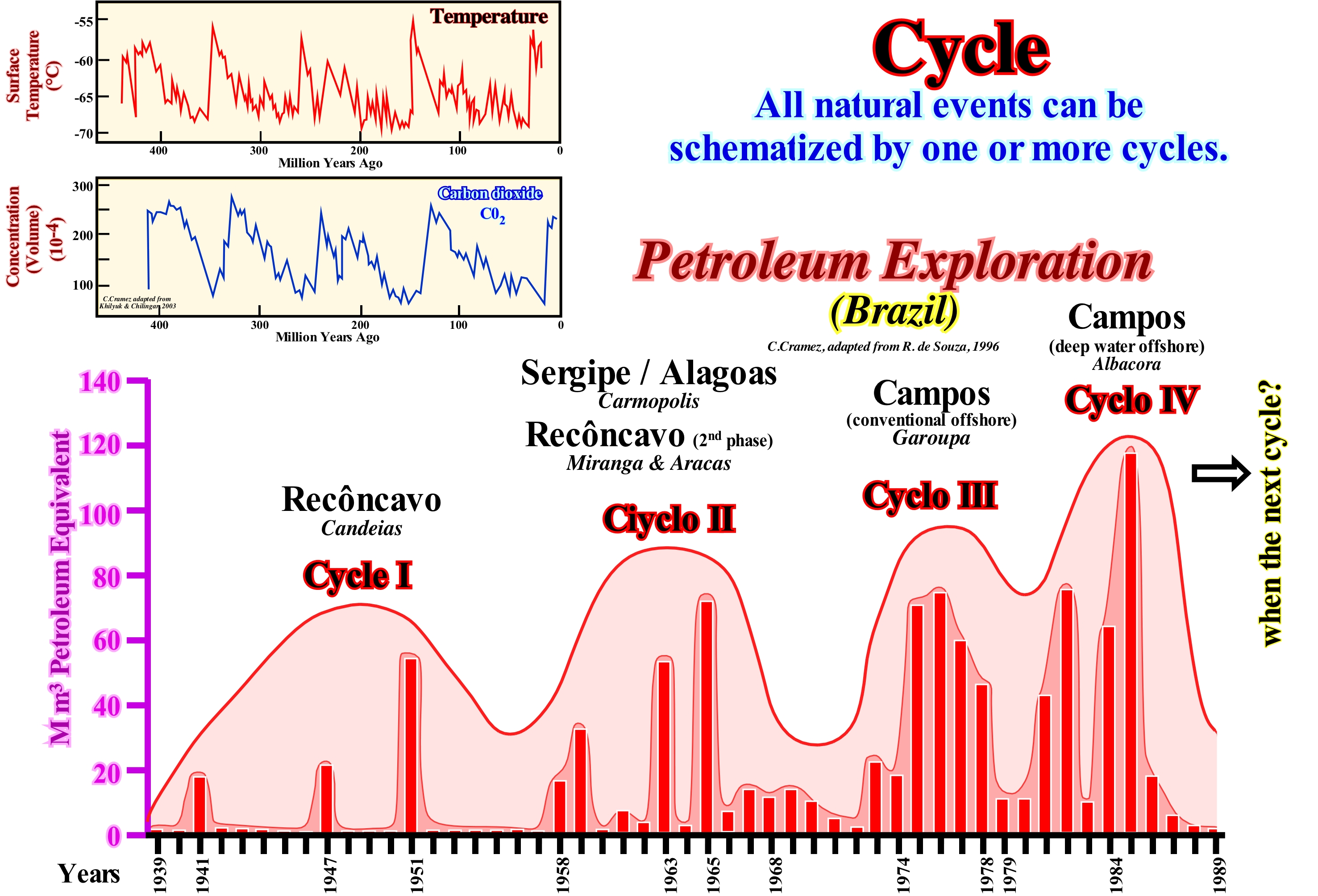
Among the great principles of nature: (i) Inequality; (ii) Self-similarity; (iii) Fractal distribution; (iv) Cyclicity; (v) Finitude; (vi) Gravity; (vii) Life; (viii) Determinism/Probabilism and (ix) Symmetry (central limit theorem), cyclicity is perhaps the most evident principle in geology and in particular in sequential stratigraphy. All natural events can be represented by one or more cycles. For several centuries, geoscientists have noticed the cyclicity of sedimentary rock depositional systems. After Benoit de Maillet and Lavoisier, the vast majority of geoscientists now think the cyclicity of sedimentary deposits is induced by eustasy (variations of absolute or eustatic sea level, which is supposed to be global and referenced to the Earth's centre). Absolute (eustatic) sea level changes, which are dependent on: (i) Tectono-Eustasy, controlled by volume variation of the ocean basins ; (ii) Glacio-Eustasia, controlled by the variation of ocean water volume as a function of the amount of ice ; (iii) Geoidal-Eustasy controlled by the distribution of ocean water caused by variations in the terrestrial gravity field, and (iv) Thermal expansion of the oceans or steric sea level rise (if the temperature of the oceans increases, the density of the water decreases and, for a constant mass, the volume increases). Earth's history, at least since the beginning of the Phanerozoic (± 600 Ma), can be described in a cyclical way. After the break-up of the Protopangea supercontinent (Rodhinia), the individualized continents dispersed to a maximum, due to the oceanic expansion (sea floor spreading). Then, since the agglutination of the ancient continental crust, along the B-type (Benioff) and the A-type (Ampferer) subduction zones, became predominant in relation to the formation of new oceanic crust by sea floor spreading, progressively, the continents clustered together again, forming the Pangea supercontinent. Similarly, the Pangea supercontinent fractured on several continents, which moved away from each other due to oceanic expansion, but which have now begun to approach* forming, probably, in a geological future, a new supercontinent. This cyclicity, which is, perfectly, explained by the Plate Tectonics Theory, is, also, found in biotic crises, climate, sea level changes, stratigraphic distribution of hydrocarbons source-rocks, etc. The day/night cyclicity, the cyclicity of the phases of the Moon, the seasons of the year, etc., marked humanity to the point that man speaks of sagittal and cyclic time. As illustrated in this figure, it seems that in the history of petroleum exploration of most productive basins, several exploration cycles can be highlighted. However, these cycles are not natural. They are the direct consequence of the gradual increase in geological knowledge of the geoscientists and the technology they use. Globally, as for any other natural material used by man, oil production will obey to certain laws. According to Hubbert's law, the annual rate of oil production depends, linearly, on the total fraction of oil that has not yet been produced. This means the total amount of oil produced follows a logistic curve and under normal conditions, as long as the oil production curve reaches its maximum, it can be said that about half the reserves have already been produced. So it can not be said that oil exploration at the global level is cyclical, once production has started, reached or will reach a maximum of production (probably between 2008 and 2012 for cheap oil) and then, irrevocably, will end. The vast majority of natural events can be schematised by one or several cycles. Roberto de Souza in his book on the history of petroleum suggested that up to 1898, four cycles can be highlighted in the offshore oil research in Brazil, whose culminating points are the discoveries of Candeias (Recôncavo), Carmopolis, Miranga and Aracas (Sergipe/Alagoas and Recôncavo), Garoupa (Campos) and Albacora (Campos). Similarly, changes in Earth's temperature and carbon dioxide (CO2) in the atmosphere during the Phanerozoic are cyclical. The peaks in temperature seem to precede CO2 peaks (about 800 years), that is to say, that, quite probably, are not the CO2 peaks that cause the peaks in temperature, as Mr. Al Gore (business man and politician who was vice-president of the United States from 1993 to 2001) is telling every-body, but probably the other way around.
(*) Portugal's offshore, whose seismic activity is unfortunately well known to everyone, seems to be induced by a B-type subduction zone that began to form along the Portuguese coast and Galicia.
Cyclostratigraphy.....................................................................................................................................................................Cyclostratigraphie
Ciclostratigrafia / Ciclostratigrafía / Zyklische Stratigraphie, Cyclostratigraphy / 旋回地层 / Циклостратиграфия / Ciclostratigrafia /
Division of sedimentary sections in units deposited as a function of Milankovitch orbital cycles. The Pleistocene, for instance, can be sub-divided into several cycles using fluctuations of oxygen (O16/O18) isotopes, which express the increase or decrease of the cryosphere in response to Milankovitch cycles.
See:« Milankovitch Cycle »
&
« Milankovitch Theory »
&
« Astronomic Theory of Paleoclimate »
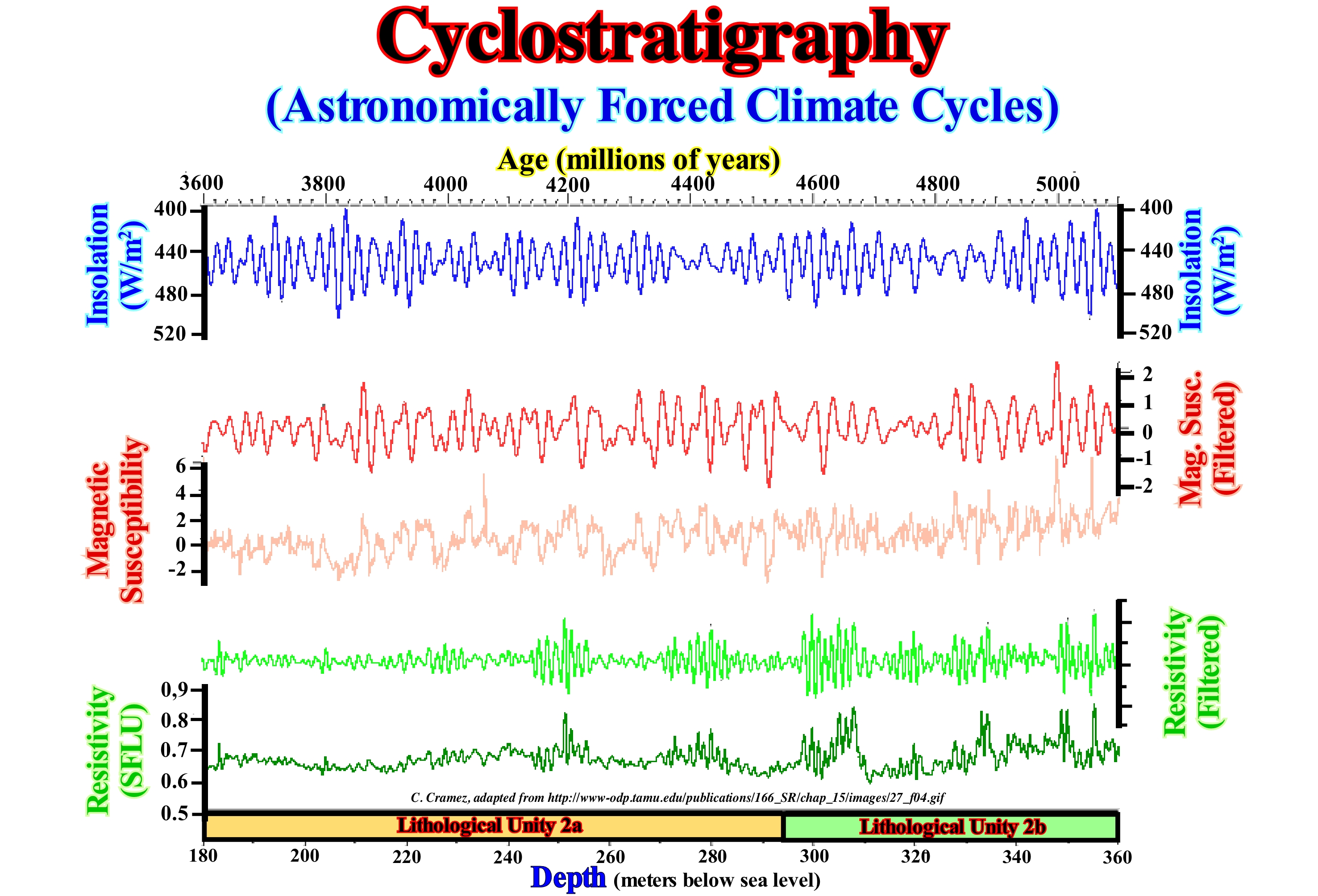
Since sequential stratigraphy (succession and interconnection between all stratigraphic cycles using field, subsurface, and seismic data) can only be understood by a holistic or systemic approach, certain geoscientists use the term Systemic Stratigraphy instead of Sequential Stratigraphy to better emphasize the global approach and the interconnection between the different geological parameters affecting the stratigraphy. The term cyclostratigraphy was proposed as a synonym of sequential stratigraphy, but this term was, already, used to designate the study of sedimentary intervals deposited in association with the Milankovitch orbital cycles. Indeed, recent sediments can be classified on the basis of oxygen isotope fluctuations to represent Earth's paleothermometry, i.e., relative changes in the cryosphere (the area of the Earth where ice and frozen soil are formed) in response to cycles of Milutin Milankovitch. The O18/O16 rate gives a record of temperature in the past (the lighter isotopes, which are stable and always the most abundant, tend to diffuse and react more easily than heavier isotopes). The water molecule consists of an oxygen atom combined with two hydrogen atoms. Oxygen is a mixture of three natural isotopes: 16O (99,76%) ; 17O (0,04%) and 18O (0,20%). In the water cycle, the 18O heavy isotope moves more difficult than the lighter isotope 16O. The 18O isotope evaporates less easily at the equator and often falls with precipitation (rain or snow) that emphasizes the water path to the poles. Polar ice caps are poorer in heavy isotope (18O) than the oceans, and this the more the climate is cold. Thus, a poor ice in 18O suggests a provenance from a cold weather season, while a less poor ice in 18O comes from a season of hot weather. In other words, precipitation (rain, snow, etc.), and therefore the water contained in the ice of the glaciers, has a low 16O content. However, since a large amount of 16O water has been stored in glacial ice and glacial ice caps, the 18O content in ocean water becomes very large. Water colder than the current average temperature (10°/15° C) suggests a glaciation. Also, marine organisms form their shells from the chemical elements contained in seawater, including oxygen. The oxygen isotope ratio constituting the shells found in marine sediments allows us to retrace the history of our planet's climate. In fact, the evolution of 18O / 16O in water is inversely proportional to the extent of the ice caps. An ocean, and therefore, sediments rich in 18O suggest poor ice caps in 18O and a cold climate (http://www.cnrs.fr/cnrs-images/ sciencesdelaterreaulycee/contenu/paleoclim1-1.htm). Diagrams illustrating water temperature in the past strongly suggest that the climate varied cyclically, with large harmonic waves (periodicals with the same frequency signal) or small cycles overlapping large ones. The isotope rate has been, widely, used to identify, during the Pleistocene, periods of maximum and minimum glaciation, as illustrated in this figure. The stratigraphic cycles of the Neogene have been associated with the variations of the sunshine caused by the oscillations of the orbit and the different orientations of the axis of the Earth (dated by the correlation between the sedimentary cycles and the calculated insolation). In the example illustrated in this figure, the sediments sometimes alternate with a silt rich in yellowish or slightly green fossil microorganisms (neritic, high sea level) and a silt with gray fossil micro-organisms and foraminifera (pelagic, low level). In upper lithologic units, the pelagic part is sometimes limited to a hardened level. The cycle begins with a clayey base level. A correlation between the insolation (**) cycles, the magnetic susceptibility (ability of a material to magnetize under the action of a magnetic stimulation of a magnetizing field to which it is subjected) and resistivity (opposition of a material to flow of electric current) is likely. The filtered version of the magnetic susceptibility and resistivity curves best emphasizes such a cyclicity.
(*) A water having a higher temperature of about 5° C than the current average represents a interglacial period, which means that its O18 content is small.
(**)The terrestrial climate is parametrized by the insolation, that is to say, by the amount of solar energy received by the Earth. The temperature variation between day and night is a remarkable example of the influence of solar energy on the Earth's climate, however short term. The source of solar radiation is considered, more or less, constant, but the positioning of the Earth in relation to the Sun varies according to several periodic factors. The insolation is cyclical due mainly to the three orbital parameters (eccentricity, slope and precession).
Cyclothem.............................................................................................................................................................................................................................Cyclothème
Ciclotema / Ciclotema / Zyklothems / 旋回 / Циклотема / Cyclothem /
Term proposed by Weller (1958) to define a series of layers deposited during transgression-regression sedimentary cycles, such as the Pennsylvanian coal layers associated with unstable platforms or cratonic basins, where sedimentary transgressions alternate with sedimentary regressions. The Pennsylvanian cyclothems were deposited due to an, extremely, flat topography of the cratonic basins (several times covered by the sea), reason why they were never covered by ice. A cyclothem is an informal lithostratigraphic unit equivalent to a geological formation.
See: « Stratigraphy »
&
« Lithostratigraphy »
&
« Transgression / Regression Cycle »
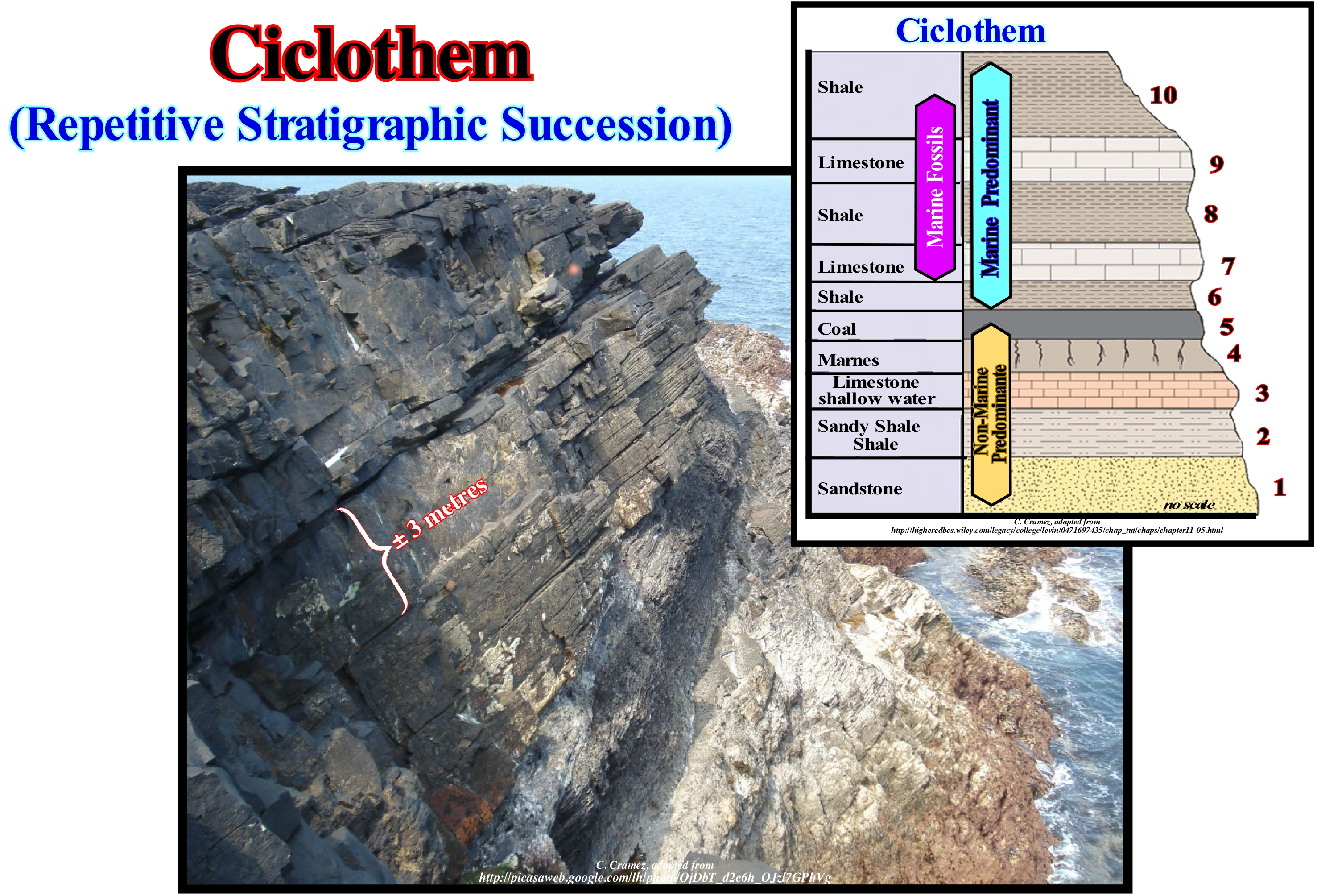
In the East sector of the United States and, particularly, in the Paleozoic cratonic basins, certain sedimentary clusters correspond to the stacking of non-marine and marine sediments, which, evidently, suggests advances and retreats of coastal deposits (sedimentary regressions and sedimentary transgressions). Each interval consisting of a stacking of non-marine and marine sediments was designated cyclothem by Weller in 1958. The average thickness of a cyclothem is about 6 meters, half of which is continental and the other half marine. In other words, a cyclothem is a sedimentary interval representing a transgressions / regressions cycle. However, many geoscientists now use the term cyclothem to designate a repeated sedimentation unit, either in cyclic or rhythmic sedimentation. In a cyclic deposition, from the bottom up, a cyclothem can be constituted by the following units: Interval 1, Interval 2, Interval 3, Interval 4, Interval 3, Interval 2, Interval 1. In a rhythmic sedimentation, a cyclothem is the set A, B, C, D of the succession A, B, C, D / A, B, C, D. Cyclothems associated with a rhythmic sedimentation are, generally, formed by: A) Coarse sandstones ; (B) Fine sandstone ; (C) Shales ; (D) Limestone, passing again to the second cycle, with the repetition of all or almost all of the depositional systems (lithology with a more or less characteristic fauna deposited in a given environment.) A cyclic sedimentary unit can be considered as a symmetrical cyclothem, while a rhythmic sedimentary unit is an asymmetric cyclothem. Although many geoscientists consider the terms cycle and rhythm as synonyms, genetically, a cyclic and a rhythmic sedimentation are associated with different geological events. A set of cyclothems form a megacyclothem, and successions of mega-cylothems form am hiper-cyclothem. Most of the cyclothems with coal extend through large continental regions forming series, although can, rarely, occur, also, in isolation. In certain areas series have been recognized with more than 10 cyclothems. In the North American, cyclothems with coal extend for thousands of kilometers square. They are are uniform in thickness and internal organization. During the Carboniferous, much of Eastern North America was a vast lowland (almost at sea level), probably, similar to the current coastal plain of the Gulf of Mexico. The stacking of these Carboniferous cyclothems cycles suggests frequent and repeated rise and fall of relative sea level (local sea level referenced to any point on the Earth's surface, which can be the sea floor or the base of the sediment, resulting of the combined action of the tectonics with the absolute or eustatic sea level, which is supposed to be global and referenced to the Earth's centre). In the stratigraphic sketch shown in this figure is illustrated a typical cyclothem of the Pennsylvanian in which 10 sedimentary units can be recognized. The lower part is composed of non-marine sediments, which end up with the depositing a level of coal (level 5). The coal layer is covered by marine sediments, which suggests a marine ingression (relative sea level rise) and submersion of the marshy area. Rich coal cyclothems were recognized in strata of the same age (Pennsylvania) in Europe. A repetition of cyclothems, i.e., the alternation of non-marine and marine deposits suggests: (i) Repeated variations in regional subsidence ; (ii) Repeated uplifts and (iii) Eustatic changes (variations in absolute or eustatic sea level) and repeated relative sea level changes. The cyclothems were, initially, identified in the USA and interpreted as an interaction between: (a) A tropical/equatorial climate ; (ii) A significant terrigeneous influx (sand and mud) and (c) Significant relative sea level changes.
(*) The post-Pangea cratonic basins (syneclises of Russian geoscientists) are like the rift-type basins, located in a continental crust, generally of pre-Mesozoic age. The Paleozoic cratonic basins, as the Michigan cratonic basin (USA), are formed in a crust of the Precambrian. These basins are not directly associated with oceanic expansion (sea floor spreading). In most cases, they develop when the breakup of the continental crust and the oceanic expansion are aborted. The North Sea cratonic basin is a magnificent example of such basins. The genesis of these basins is still very enigmatic. The geological models proposed to explain the magnitude of subsidence and the uplift of the cratonic arc (anticlesis in the Russian literature) are not very satisfactory.

