

Epeiric Platform..........................................................................................................................................Plate-forme épéirique (Épirique)
Plataforma epírica / Plataforma epéirica (epírica) / Epeiric Plattform / 伸入内地的台地 / Внутренняя платформа / Piattaforma Epeirica /
Ramp type platform characterized by a weak deposition rate, wide facies belts and gradual lithological transitions. This type of platform is dominated by low energy environments and subtidal or intratidal sedimentary particles.
See: « Basin Edge »
&
« Continental Platform »
&
« Tidal Delta »
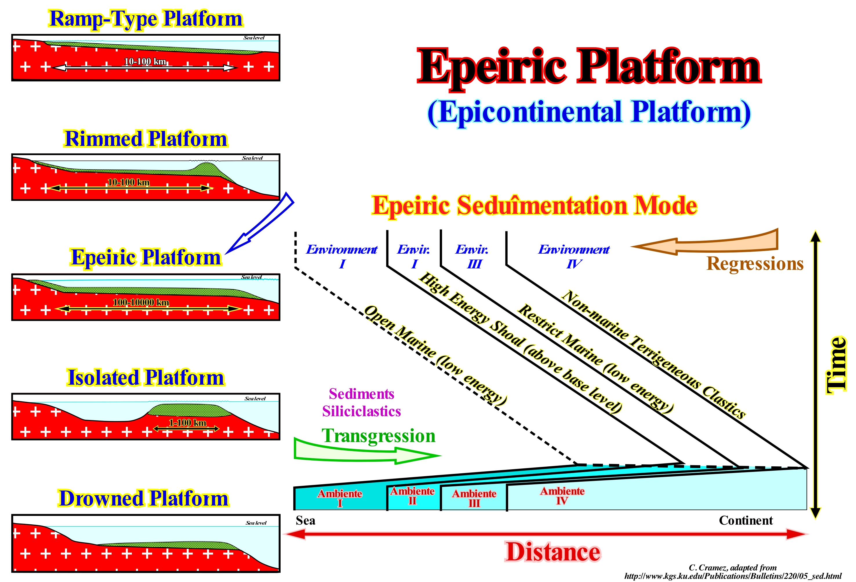
In this figure, the diagram on the left shows the different types of carbonated platforms: (i) Ramp-type Platforms ; (ii) Rimmed Platforms ; (iii) Epeiric (or epíric) Platform ; (iv) Isolated Platforms ; (v) Drowned or Dead Platforms. In ramp-type platforms the carbonated sands of the shoreline pass at the base of the ramp to clay sands and deep water muds. In this platform type reefs are rare ; the width of the ramp can reach 100 km). Rimmed Platforms¨ are characterized by the presence of reefs or calcareous sand shoal (carbonated sandbank covered by shallow sea water) on the platform edge and clay sands in the lagoon or the open platform (this type of platform forms in calm waters. Its extension varies between 10 and 100 km). Epeiric (or epíric) platforms are characterized by the presence of tidal surfaces and protected lagoons. The width of an epeiric platform can reach 10000 km. In isolated platforms the facies (lithologies) are controlled by the orientation of the prevailing winds. These platforms have reefs and sandy bodies, as the rimmed platforms, in the windward margin (facing the side where the wind blows), but in the leeward margin (in the direction where the wind blows), the sediments are more muddy. An epeiric platform can reach 100 km wide. Drowned or dead platforms are below the photic zone. i.e., where there is not enough light for photosynthesis (use of carbon dioxide, CO2, and water to obtain glucose through the energy of sunlight. In the sedimentation model of an epeíric platform shown in this figure, four sedimentary environments can be recognized. From the sea continentward and marine ingressions (relative sea level rise resulting of the combined action of the absolute sea level of tectonics) increase, in distance and time, we can recognize: (i) Environment I or Open Marine characterized by low energy ; (ii) Environment II or Low-energy Shoal, which is above the base level ; (iii) Environment III or Restricted Marine, which is characterized by low energy and (iv) Environment IV or Transitional which is characterized by the presence of non-marine terrigeneous clasts. In the platforms connected to the continent, the large majority of the geoscientists consider two large families: (A) Ramp Type Platforms and (B) Flat-topped Platforms. In the Flat-Topped Platforms they consider two subtypes: (B.1) Rimmed platforms and (B.2) Nonrimmed Platforms. It is rimmed platform that the designation of abrupt carbonated platform is more frequent. In ramp type platforms, they consider two sub-types: (A.1) Homoclinal Ramp platforms and (A.2) Distally-steepened ramp platforms. Ramp-type platforms are formed when carbonate formation processes are associated with cold climate. On the contrary, in flat-topped platforms, the processes of carbonate formation are associated to tropical climate. Take into account that under normal geological conditions, the water-depth of a limestone platform can not exceed the depth of the photic zone, otherwise carbonate formation (photosynthesis) can not occur. A carbonated platform may coincide with a continental shelf but, in general, this seems to be an exception. In general, a continental shelf, has a water-depth that varies between 0 and 200 meters, which means that the greater part of the continental shelf has a water-depth higher than the photic zone. The most well known carbonate platform geometry is associated with tropical manufacturing processes, where carbonate platforms can be sub-divided into three main sedimentary environments: A) Reef, which is the part of the carbonate platform created in situ by sessile organisms ; B) Internal lagoon, i.e., the part of the platform behind the reef, which is characterized by shallow and calm waters with sediments composed of fragments of reefs and hard parts of organisms or sediments terrigeneous when the reef is epicontinental and C) Slope Reef, which connects the reef to the basin and acts as a sink for the excess carbonate sediment, although most of the sediment produced in the lagoon and the reef is transported by various processes and accumulated on the slope.
Epeiric Sea (Epicontinental sea).....................................................................................................................................Mer épicontinentale
Mar epicontinental / Mar epicontinental / Epicontinental Meer / 陆表海 / Воды открытого моря над континентальным шельфом / Epicontinental mare /
Sea located on the continental shelf or within a continent.
See: « Tethys Sea »
&
« Rheic Sea »
&
« Iapetus Sea »
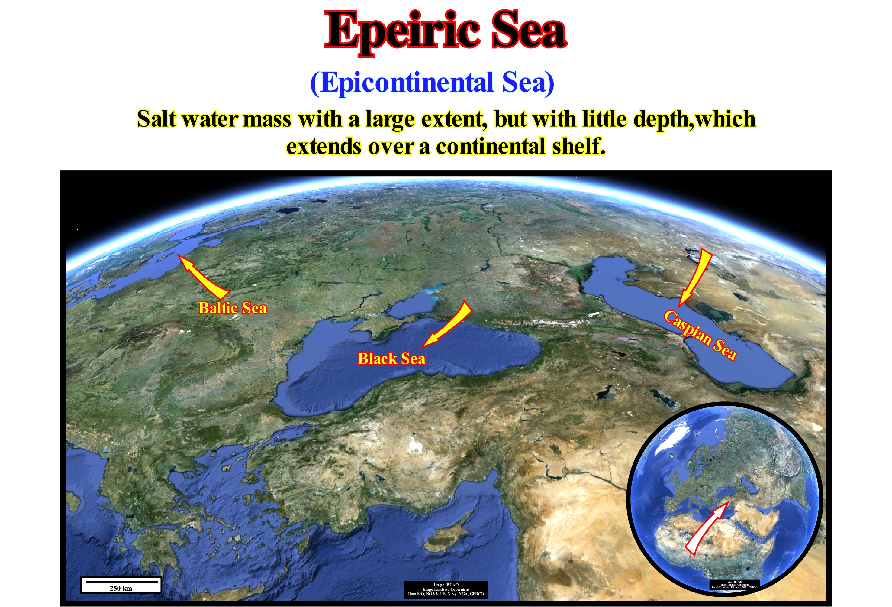
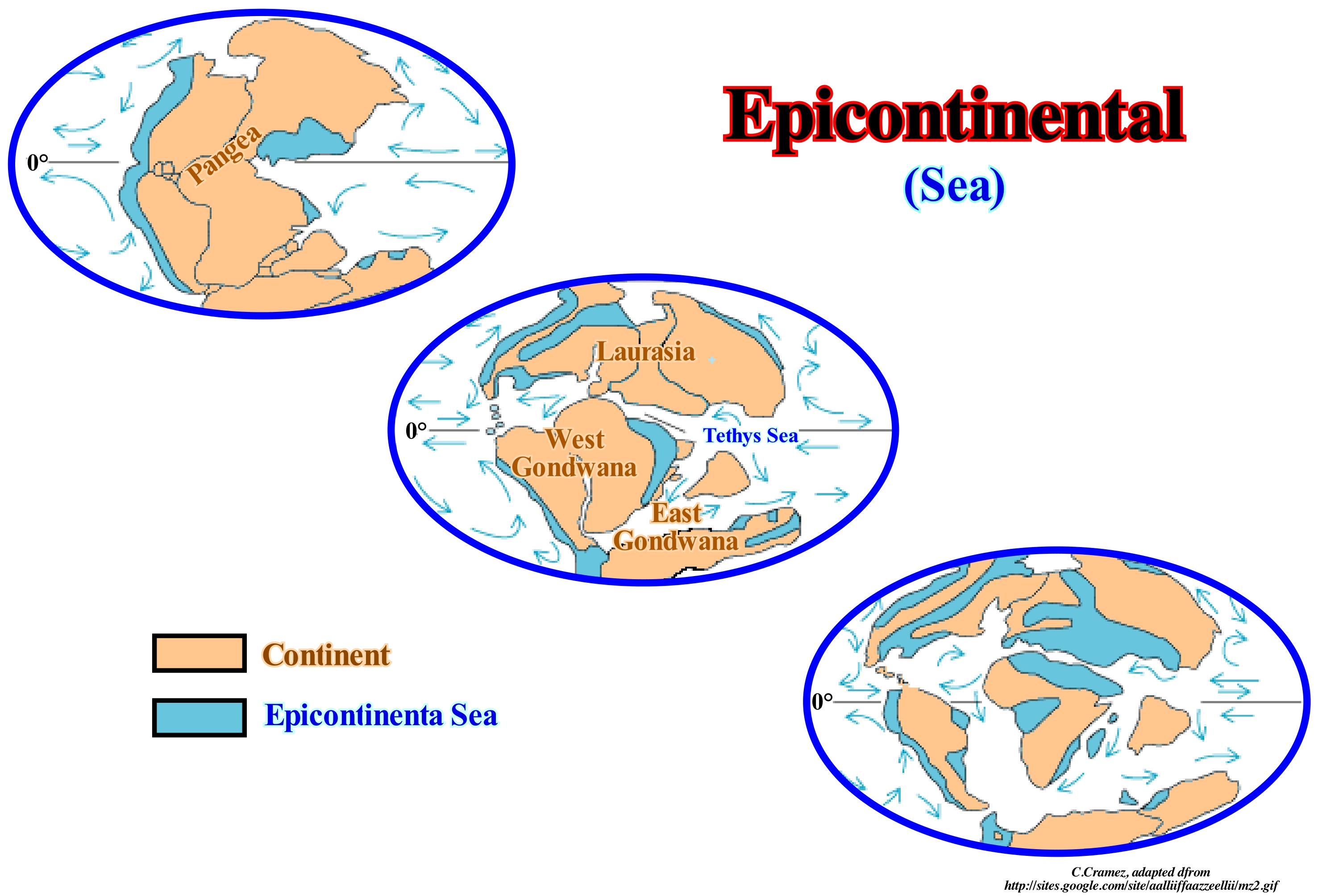
An epicontinental sea (also called epeiric or epiric sea) is a large, relatively shallow, body of water that extends into the interior of the continent, such as the Persian Gulf or, overlapping a large area of the mainland (Caspian Sea), as illustrated in this figure. In Europe, presently, there are several epicontinental seas: (i) Black Sea ; (ii) Caspian Sea ; (iii) the Baltic Sea, etc., which are, actually, traces of older seas, which were closed due to the movements of the lithosphere plates. Epicontinental seas are, often, associated with the Cenozoic marine ingressions (displacement of the shoreline and associated coastal deposits continentward). Many of these seas formed after the last Ice Age, when sea level rose (due to the melting of ice) faster than the isostatic rebound or uplift of the continents (North Sea, Hudson Bay, etc.). The same happened during the eustatic rise, which occurred during the Cretaceous. Due to sea level rise, especially, during the Late Cretaceous, the sea has flooded the continents creating several shallow epicontinental seas in North America, South America, Europe, Russia, Africa and Australia, as the surface of the continents declined once their margins were flooded. At the maximum of the Cretaceous transgression, the onshore of the continents corresponded to about 18% of the Earth's surface, which is, relatively, little compared to the about 28% of current situation. During this period, the Arctic waters were connected with the Tethys Sea via the central part of America and Russia. On several occasions, marine animals that lived in the South Atlantic migrated to the Tethys Sea through the regions that today correspond to Nigeria, Niger, Chad and Libya. This means that during Cretaceous time, Western Europe, Eastern Australia, South America, India, Madagascar, Borneo, etc., which are now continental areas, were covered by sea-water. Sequential stratigraphy suggests, at this time, between 5 and 15 important relative sea level rises (transgressions or ingressions as some authors say), induced the formation of several important epicontinental seas.
Epeirogenesis..........................................................................................................................................................................................................Épirogénèse
Epirogénese / Epirogénesis / Epeirogenesis (Tektonik) / Epeirogeny 口水 (构造) / Эпейрогенез, эпейрогенетическое движение / Epeirogenesis (Tettonica) /
A form of diastrophism which, according to certain geoscientists, produced the great components of the continents and oceans, but which contrasts with the orogenies (more localized process), which produced the mountain chains. The epirogenic movements are mainly vertical and affect large sectors of the continents, not only the cratons, but also the stabilized mountain chains, where they produced the current mountainous topography. Epirogenic structures may become orogenic, but most contrast strongly. Synonym of Epirogeny.
See : « Craton »
&
« Epirogeny »
&
« Orogenesis »
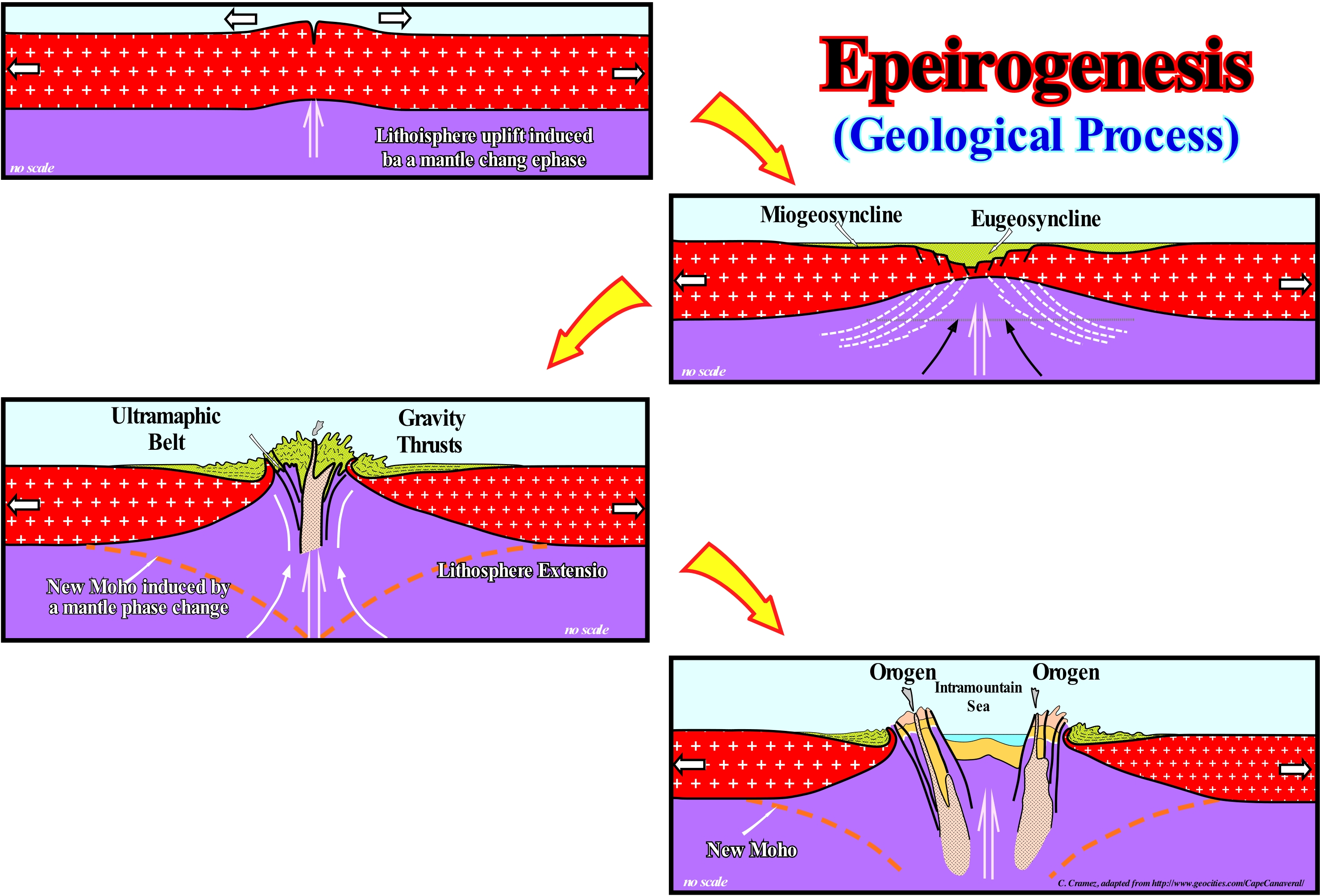
Epeirogenesis and associated terms were frequent, in the 1960s, before the advent of the tectonic plate theory, which explains much better the observations that epeirogenesis has attempted to explain. The hypothesis, which Carey advanced to explain the diapirism observed on the Pacific margins, was based on the fact that the warm, low-density volcanic material, forming the diapirs, deforms in a plastic manner. It is warmer, than the surrounding material that confines them, but also because it is pulled up by a much warmer upward underlying material. The ascension of the diapirs is not just induced by the density and viscosity of the material constituting them. In the orogenic zones, the isotherms are always several kilometers higher than in the stable zones, due to the upward movement of the warmer lower material. According to Carey, who is one of the epeirogeny's fathers, everything moves, vertically, and upward. For him, once the volcanic material reaches the surface, it flows laterally by gravity. Gravity controls folding as well as the shortening, by inverse faults, induced by vertical and continuous movement of the underlying material. Since diapiric orogenic belts are formed, the crust becomes thinner and warmer as deformations occur. Extensional deformations (lengthening by normal faulting) suggest the epeirogeny develops in fragile zones of the crust. Old epeirogenesis can be reactivated. For Carey, this would be the process that controls the reactivation of the old orogenies and not the Wilson's cycles*, that is, the periodic collisions between the continents resulting from break-up of the supercontinents, as suggested by plate tectonics theory.
(*) An advanced hypothesis by the Canadian geoscientist J. Tuzo Wilson (1908-1993), in which the cyclic opening and closing of the ocean basins is caused by the movement of the lithospheric plates. The Wilson cycle begins with an ascending magma plume and lengthening of the overlying crust. As the crust continues to thinning due to the extensive tectonic forces, oceanic basins are formed and sediments accumulate along the margins. Later, as a consequence of the sea floor spreading, a subduction zone is initiated in one of the margins. The activity of the subduction zone induce the closing of the oceanic basin. When the crust starts again to lengthen a new cycle starts. In the Wilson cycle, the following tectono-stratigraphic phases can be recognized: (i) Stable Continental Craton ; (2) Thermal Anomaly and Lengthening ; (3) Lithosphere Break-up ; (4) Sea Floor Spreading or Oceanic Expansion ; (5) Subduction ; (6) Divergent Margin / Volcanic Arc Collision with formation of a folded belt ; (7) Peneplanation (the folded belt is reduce almost to a plain by erosion) and Subduction ; (8) Continent-Continent Collision and (9) End of the Wilson's cycle with the formation of a new stable continental craton.
Epibenthos (Organisms).........................................................................................................................................................Épibenthos (Organismes)
Epibentos / Epibentos (organismos) / Epibenthos (Wohnen über der Sedimentoberfläche) / Epibenthos (以上表层沉积物的生活) / Эпибентос / Epibenthos (Vivere al di sopra della superficie del sedimento)/
Organisms that live on the sea-bed or, immediately, above. Some epibenthos are connected to the bottom of the sea, but others are mobile. Sponges, corals and starfish are examples of epibenthos.
See: « Benthos »
&
« Mesobenthos »
&
« Merobenthos »
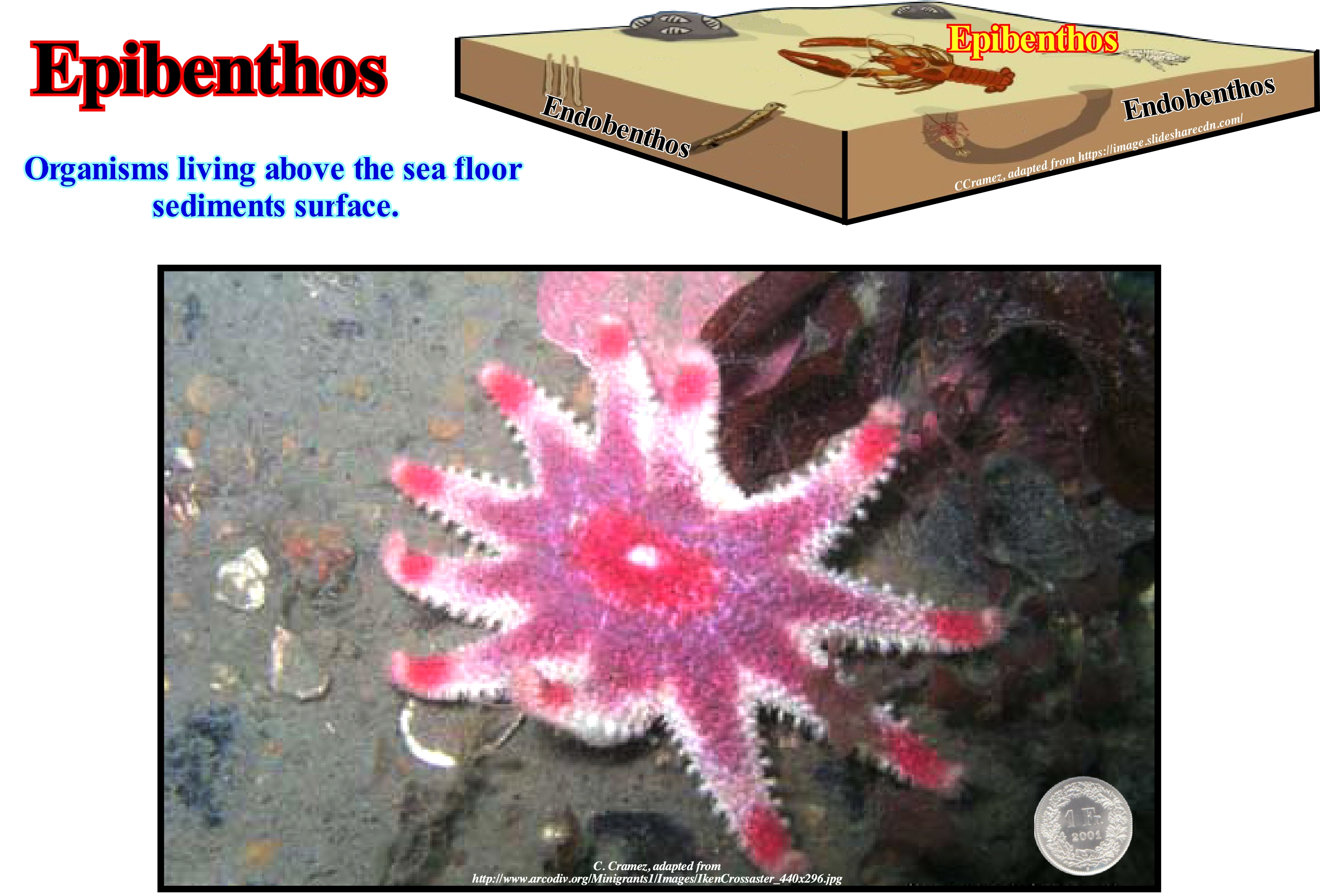
Benthos or benthic organisms include species that live above the surface of the sediment (epibenthos) and species that live below the surface of the sediment (endobenthos). This distinction is not always clear. Certain organisms, such as some Sabelid worms, live in both environments. Traditionally, for most geoscientists, epibenthos organisms include the fraction of benthos that is directly on the bottom of the sea and not buried (infauna or endobenthos). Within epibenthos organisms, two different life strategies have been developed: (i) Fixed or sessile epibenthos, that is to say, organisms that do not move and are permanently attached to the substrate (e.g., sponges, gorgonians, i.e., sessile colonial cnidarians , corals, crustaceans, bryozoans, etc.) and which are, essentially- filters since they feed on sea-grass* and (ii) Mobile and vagile epibenthos, i.e., that have the ability to actively move on the bottom (as for instance, wandering polychaetes, gastropods, crustaceans, fish etc.), and which have different dietary resources. The mobile epibenthos include species of carnivores, necrophagous, detritophages and some suspenders, which feed on organic matter, phyto and zooplankton, which is suspended in the water column. Suspenders are also known as filter feeders filterers, although many of them do not actually filter the water since they have mucosa areas and eyelashes to which the food particles adhere. Examples of epibenthos include: (a) Gastropods: Atlanta lesueruri, Benthonella tenera, Gastropoda Prosobranchia, Creseis acidula, Clio sp., Cavolinia sp., Notauchis punctatus, Roxania utriculus, Gastropoda Opisthobranchia, etc. ; (b) Bivalves: Bathyarca philippiana, Bathyarca grenophia, etc., and (c) Polychaetes: Aphroditimorfa, Hyalinoecia s.p., Peruas sp., Flabelligeridae, Terebelidae, etc.
(*) A set of organic and non-organic particles which are dispersed in the water column and which, in addition to being a good food for some organisms, play an important role in the diffusion of light in water and therefore in primary production.
Epicentre (Earthquake).................................................................................................................................................................................................Épicentre
Epicentro / Epicentro / Epizentrum / 震中 / Эпице́нтр / Epicentro /
Point of the Earth's surface, immediately, above the hypocenter (focus), i.e., the point of rupture that originated the earthquake.
See: « B Subduction (Benioff) »
&
« Tsunami »
&
« Seismic Wave »
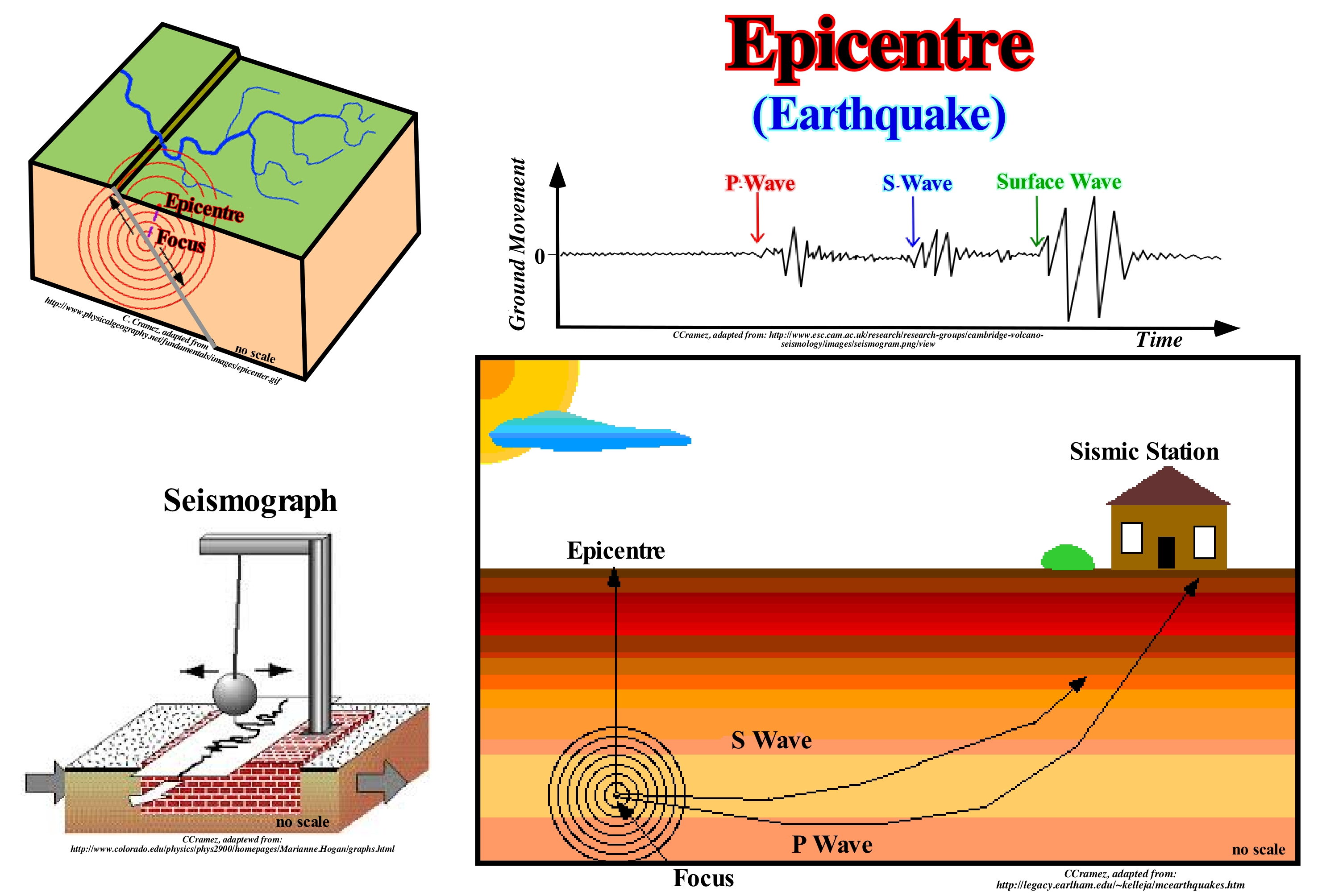
During an earthquake, the seismic waves propagate in a spherical way from the focus (hypocenter). A seismic shadow appears on the opposite side of the Earth from the epicentre of an earthquake. The Earth's outer core, being liquid, refracts the longitudinal or compressional waves (P waves). They have same vibration and propagation direction. On the contrary, Earth's outer core absorbs transverse or shear waves (S waves), which vibrate perpendicular to the direction of propagation. Between 104° and 140° from the focus of an earthquake, few or no seismic waves can be detected. The primary waves (P waves) are refracted by the Earth's core and the secondary waves (S waves) are interrupted by the same core. Outside the seismic shadow zone both wave types can be detected, but, due to their different trajectories across the Earth, they arrive at different times. Measuring the time differences in any seismograph, as well as, the distance in a distance-time graph, in which the P and S waves have the same separation, geoscientists can calculate the distance from the epicentre of the earthquake. This distance, called epicentral distance is, usually, measured in degrees and denoted as Δ (delta), in seismology. Since the epicentral distance is known, for at least three seismographic stations, the position of the epicentre can be easily calculated by a simple triangulation. The epicentral distance is also used in the calculation of the seismic magnitudes developed by Gutenberg and Richter, which have no limits, neither superior nor inferior. The maximum magnitude is limited by the crust and upper mantle strength. From the beginning of instrumental seismology, no earthquakes with a magnitude greater than about 8.6 have been observed. The largest recorded earthquakes were in Chile in 1960, with an estimated magnitude of 8.5 and in Alaska, in 1964, in which the magnitude reached 8.6. Many geoscientists think that rocks can not store more elastic energy than this (± 6,3 1023 ergs). However, it is possible that those caused by meteorite impacts have larger magnitudes.
Epicontinental (Sea)...............................................................................................................................................................................Epicontinental
Épicontinentale / Epicontinental / Epikontinental / 陆缘 / Эпиконтинентальный / Epicontinentali (mare) /
Shallow sea extending over a part of a continent.
See: « Epicontinental Sea »
&
« Shelf »
&
« Relative Sea Level Change »
An epicontinental sea is the portion of the sea that is on the continental shelf and the portions that extend towards the interior of the continent with similar characteristics with respect, above all, to the water-depth. An epicontinental sea is also known as the epeiric sea or inland sea. As illustrated in these schemes, the formation and disappearance of epicontinental seas are closely associated with the transgression/regression cycles. During a significant relative sea level fall, coastal onlaps are shifted seaward and downward. The shoreline (limit between offshore and onshore), as well as, sea level will be situated below the continental edge (do not confuse continental edge with basin edge, although, under certain geological conditions, they may coincide). In this way, the continental shelf will be, totally, exhumed and transformed in a coastal plain delimited downstream by the shoreline. If this happens, the epicontinental portion of the sea will disappear. The interior portions may either disappear altogether or become, more or less, isolated or become lakes. With a relative sea level rise (eustasy plus tectonics), even if the geological conditions at the beginning were lowstand (sea level lower than the basin edge, which in this case coincides with the continental edge because the basin has no platform), the coastal plain, limited downstream by the shoreline, will be flooded as the relative sea level rises. Progressively, a continental shelf is formed. The water-depth increases as the shoreline and the coastal deposits coastal onlaps) move continentward. This relative sea level rise may be sufficient to extend inland the epicontinental sea. This happens every time the continental encroachment (horizontal component of coastal aggradation) is important or, in other words, when the topography of the pre-existent sediments is, relatively, flat. Under such conditions, a relative sea level rise (marine ingression) of 10 meters can, locally, displace the shoreline continentward hundreds of kilometers. During the marine ingression, the wave base action creates on the pre-existing topographic surface a ravinment that, at least, in sequential stratigraphy, it is by no means an unconformity. Recall that an unconformity is an erosional surface created by a significant fall of the relative sea level (local sea level, referenced to any point of the Earth's surface that can be the base of the sediments, i.e., the top of continental crust or the sea floor and that is the result of the combined action of absolute or eustatic sea level and tectonics).
(*) Absolute or eustatic sea level is the sea level referenced to the Earth’s centre or to a satellite. It is dependent on: (i) Tectono-eustasy (change of volume of ocean basins in association with sea floor spreading following a supercontinent break-up) ; (ii) Glacio-eustasy (change of water volume of the oceans as a function of the amount of ice, assuming that the amount of water, in all its forms, is constant since the Earth formation, around 4.5 Ga) ; (iii) Geoidal-eustasy (distribution of ocean water caused by variations in the terrestrial gravity field and (iv) Steric rise of sea level or sea thermal expansion.
Epicontinental Sea (Epeiric sea).......................................................................................................................Mer Épicontinentale
Mar epicontinental / Mar epicontinental / Epicontinental Meer / 陆表海 / Воды открытого моря над континентальным шельфом / Epicontinental mare /
Sea located on the continental shelf or within a continent.
See: « Tethys Sea »
&
« Rheic Sea »
&
« Iapetus Sea »
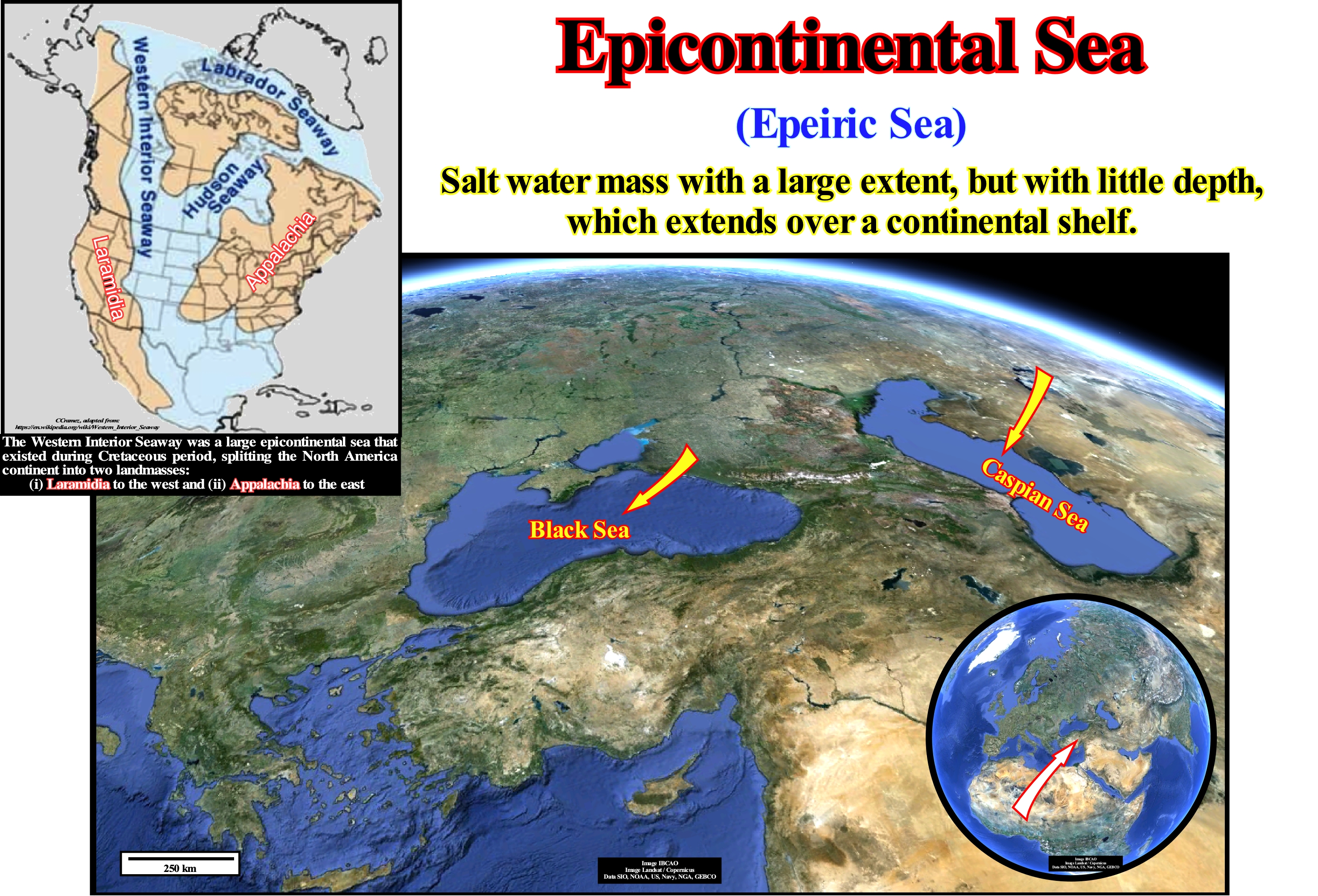
An epicontinental sea (also called epeiric or epiric sea) is a large, relatively shallow, water-body that extends into the interior of the continent, such as the Black Sea or, overlapping a large area of the mainland (Caspian Sea), as illustrated in this figure. In Europe, there are, presently, several epicontinental seas: (i) Black Sea; (ii) Caspian Sea; (iii) Baltic Sea, etc., which are, actually, traces of older seas, which were closed due to the movements of the lithosphere plates. Epicontinental seas are, often, associated with the Cenozoic marine ingressions (displacement of the shoreline and coastal deposits continentward). Many of these seas formed after the last Ice Age, when sea level rose (due to the melting of ice) faster than the isostatic rebound or uplift of the continents (North Sea, Hudson Bay, etc.). The same happened during the eustatic rise, which occurred during the Cretaceous. Due to sea level rise, especially during the Late Cretaceous, the sea has flooded the continents creating several shallow epicontinental seas in North America, South America, Europe, Russia, Africa and Australia, as the surface of the continents declined once their margins were flooded. At the maximum of the Cretaceous transgression, the onshore of the continents corresponded to about 18% of the Earth's surface, which is relatively little compared to the current situation of about 28%. The Western Interior Seaway (also called the Cretaceous Seaway, the Niobraran Sea, the North American Inland Sea, and the Western Interior Sea) was a large inland sea that existed during the mid- to late Cretaceous period as well as the very early Paleogene, splitting the continent of North America into two landmasses, Laramidia to the west and Appalachia to the east. The ancient sea stretched from the Gulf of Mexico and through the middle of the modern-day countries of the United States and Canada, meeting with the Arctic Ocean to the north. At its largest, it was 2,500 feet (760 m) deep, 600 miles (970 km) wide and over 2,000 miles (3,200 km) long. During this period, the waters of the Arctic were connected with the Tethys Sea via the central part of America and Russia. On several occasions, the marine animals that lived in the South Atlantic migrated to the Sea of Tethys through the regions that today correspond to Nigeria, Niger, Chad and Libya. This means that during a part of the Cretaceous, Western Europe, Eastern Australia, South America, India, Madagascar, Borneo, etc., which are now continental areas, were covered by sea water. Sequential stratigraphy suggests, at this time, between 5 and 15 important relative sea level rises (transgressions or entanglements, as some authors say), induced the formation of several important epicontinental seas.
Epifauna ............................................................................................................................................................................................................................................Épifauna
Epifauna / Epifauna / Epifauna (Faune) / Epifauna (動物相) / Эпифауна / Epifauna (Faune) /
Benthic fauna living on a surface either on the surface of the seabed, on the surface of other organisms or on the surface of an object (rock, sunken vessel, etc.). Synonym of Epibenthos.
See: « Benthos »
&
« Infauna »
&
« Exogen »
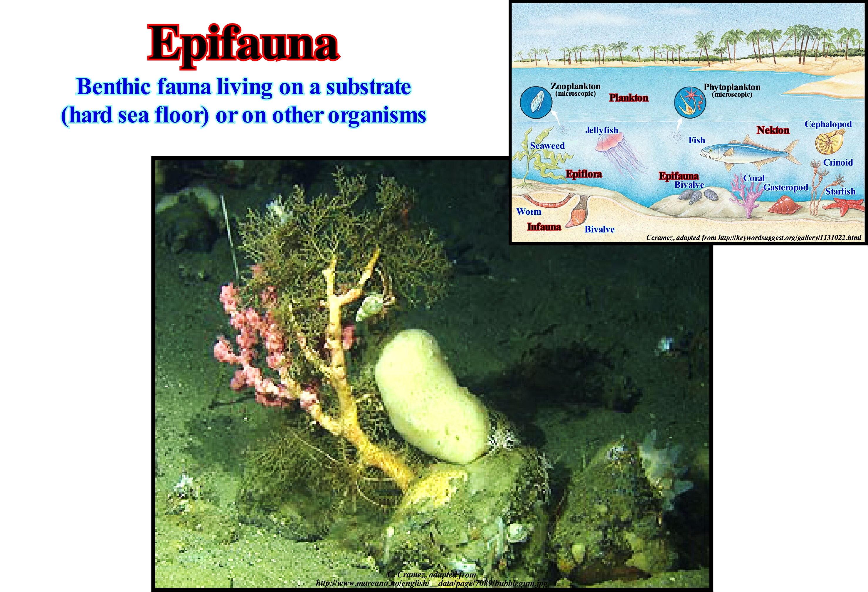
The fauna, i.e., the animal life of a particular region or in a given geological time, may be divided into: (i) Infauna or endofauna, i.e., all animals that live buried in marine or freshwater sediments ; (ii) Epifauna or Epibenthos, includes aquatic animals that live on the bottom substrate and not within it (infauna), that is to say, the benthic fauna that lives on the surface of the sediment of the sea floor ; (iii) Macrofauna, are benthic (which live on or within the bottom sediments of a waterbody) or terrestrial organisms that are retained in the 0.5 mm sieve ; (iv) Megafauna are large animals of a particular region or geological age ; (v) Meiofauna, are small benthic invertebrates living in both marine and fresh-water environments (the term meiofauna vaguely defines a group of organisms by their size, larger than micro-fauna but smaller than macro-fauna, and not a taxonomic group) ; (vi) Mesofauna encompasses terrestrial macroscopic invertebrates such as arthropods, earthworms and nematodes or cylindrical worms, etc. ; (vii) Microfauna, are microscopic organisms or very small animals (usually including protozoa, rotifers, which are tiny animals present in the plankton). We can say that, benthos or benthic animals are found in all the depths and are associated to all the type of substrates. About 80% of the benthic animals belong to the epifauna. These are animals that live or are attached to the surface of rocky areas or consistent sediments. The benthic ones that live buried in the substrate belong to the endo-fauna (in-fauna) and are, usually, associated with soft sediments, like sand or mud. Some sea-birds are sessile as adults (Cirripedia, Anthozoa, Bivalvia), while others are, permanently, mobile (crustaceans, echinoderms and molluscs). Most benthic forms produce mobile larvae that spend a few weeks of their cycle living as mero-planktonic (biphasic life cycle), allowing species to avoid over-population and colonize new areas.
Epipelagic (Organism).............................................................................................................................................................Épipélagique (Organisme)
Epipelágico / Epipelágico (organismo) / Epipelagic (am Leben sein) / 光合作用 / Эпипелагический (организм) / Epipelagico (essere vivo) /
An organism that lives in the epipelagic zone, i.e., in the upper horizon of the ocean, which is located, more or less, between the surface of the sea and 200 meters of water-depth. It is in this zone, which represents just 2-3% of the whole ocean, that photosynthesis is possible.
See: « Epipelagic (zone) »
&
« Infauna »
&
« Bathypelagic »
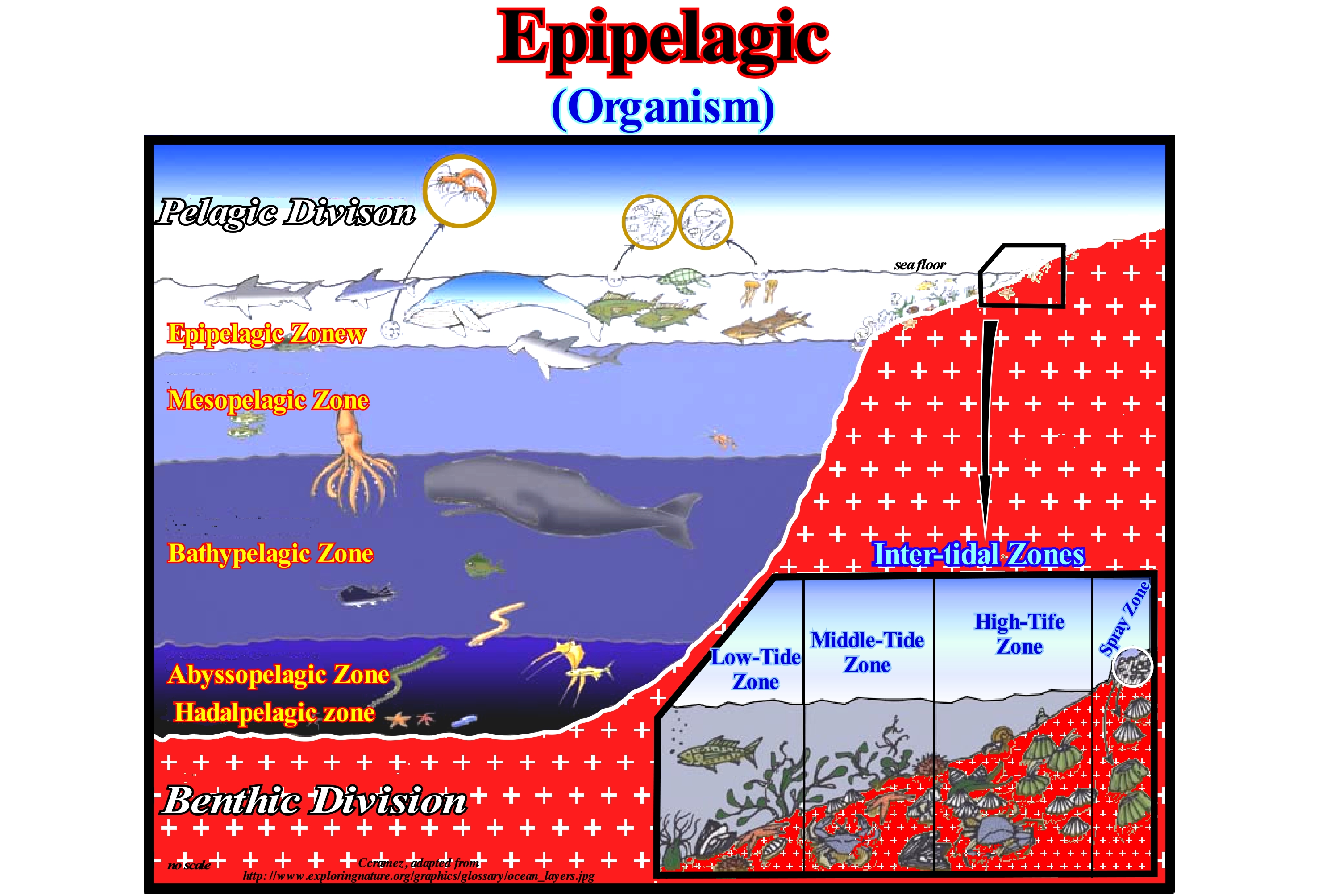
There are several water intervals from the surface to the bottom of the ocean. The epipelagic zone or euphotic zone, where lives 90% of all life forms the ocean. This zone is the closest to the Sun where the plants grow. This area has the necessary light for photosynthesis* to occur. Since sunlight is abundant, this area has a lot of life and particularly a large variety of algae. Plants with flowers and a great variety of big algae live in this area. Another unique quality of the epipelagic zone is the absence of sediments, Outside the continental shelf, this zone has no bottom. Without sediment, there are no detritivorous** (detritophages, detritus feeders, or detritus eaters), but rather an excess of suspension eaters, that is to say, organisms that feed on food that floats in water. It is in this area that you will find some of the most familiar animals in the ocean such as shark, tuna, jellyfish, sea turtles, but also blue whales, killer whales and dolphins. Most common fish that humans consume are found in this water layer. As epipelagic organisms we may mention (A) Plankton (organisms that can not swim against current) in which one can consider : (i) Picoplankton (0.2-2 mm) and Nanoplankton (2-20 μm), most of the bacteria and small unicellular algae ; (ii) Netplankton (> 20 μm), which includes large phytoplankton and all zooplankton ; (B) Phytoplankton, which accounts for more than 95% of ocean photosynthesis and more than half of the Earth's primary production ; the main organisms are the diatoms and dinoflagellates, as well as, the cyanobacteria, which are capable of fixing nitrogen, that is to transform the inorganic nitrogen into organic nitrogen that can be used by phytoplankton ; (C) Protists ; (D) Zooplankton and (E) Necton, i.e., organisms that can swim against a current, such as fish, squid, marine mammals, turtles, sea-birds, etc., which are mainly carnivorous predators, although some eat plankton or small necton.
(*) Fixation of carbon by green plants under sunlight, i.e., light energy is converted into chemical energy and stored as sugar. Photosynthesis occurs in plants and some algae (Protista Kingdom). Green plants need only the energy of light, CO2 and H2O to make sugar. Photosynthesis occurs in chloroplasts, specifically through chlorophyll.
(**) Detritivorous or saprotrophic organisms that feed on debris, i.e., a heterotrophic organism that obtains nutrients from debris (decomposing organic matter), which contributes to the decomposition and recycling of nutrients.
Epipelagic (Zone).....................................................................................................................................................................................Épipélagique (Zone)
Epipelágica / Epipelágica (zona) / Epipelagic (Bereich) / 光合作用 (区) / Эпипелагическая (зона) / Epipelagico (zona) /
Upper layer of oceanic areas that goes to a depth of about 200 meters, and in which, due to the relatively warm temperature and the abundance of sunlight allowing photosynthesis, is located about 90% of marine life.
See: « Organic Production »
&
« Photic Zone »
&
« Paleobatimetry »
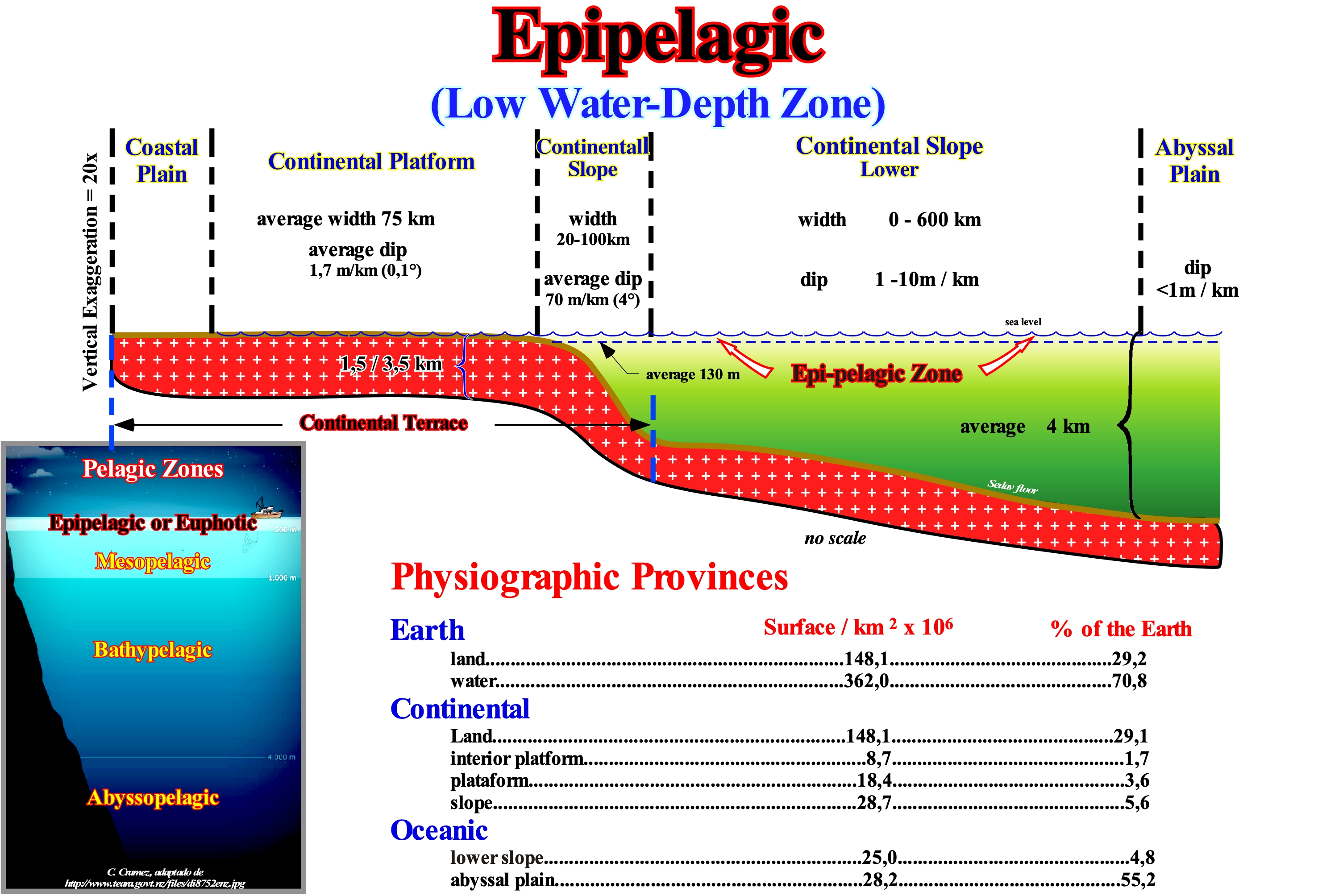
As illustrated in this figure, when an ocean basin has a continental shelf (water-depth between 0 and 200 meters), the epi-pelagic zone, adjacent to the continents, is, probably, the richest in marine life. Nutrients are very abundant. This is particularly true when an upwelling marine current (rich in oxygen and other nutrients) is located near continental edge and feeds the platform. Under these conditions, i.e., in highstand geological conditions (sea level higher than the basin edge), the shoreline does not coincide with the continental edge, which coincides with the basin edge. The basin has a continental shelf. When the sea level is lower than the basin edge (old continental edge), which means, under lowstand geological conditions, the basin has no shelf. The epipelagic zone, adjacent to the continents, does not exist. It is limited to the upper layer of the open sea. It is in the epi-pelagic zone, which runs from sea level to a depth of about 200 meters (corresponding, more or less, to the euphotic zone). The phyto-plankton (algae and microscopic algal plants) lives in the epipelagic zone. It is the primary producer of the oceans*. The phytoplankton forms the lowest level of the oceanic food chain. Using the process of photosynthesis, the phyto-plankton converts carbon dioxide (CO2), water (OH2) and other nutrients into simple carbohydrates (carbohydrates), providing food for it and for higher organisms. Photosynthesis is the physical-chemical process, at the cellular level, carried out by living beings with chlorophyll, using carbon dioxide (CO2) and water (OH2), to obtain glucose (C2H12O2) through the energy of sunlight, according to the following equation: Solar light + 12H2O + 6CO2 → 6O2 + 6H2O + C2H12O2. Photosynthesis starts most of the food chains on Earth. Without it, animals and many other hetero-trophic beings would be unable to survive because the basis of their feeding will always be on the organic substances provided by the green plants. At the top level of the pelagic food chain are the primary consumers, zooplankton (microscopic animals). The zooplankton feeds on phyto-plankton and, in turn, becomes the food of larger animals (secondary consumers) such as sardines, herring, tuna, and other types of fish and aquatic mammals. At the top end of the food chain are final consumers, such as toothed whales (the whale feeds mainly on plankton), etc. Under the epi-pelagic or euphotic zone, one finds, successively, the meso-pelagic zone (between 200 m and 1,000 m depth), the bathypelagic zone (between 1000 m and 4000 m depth) and the abyssopelagic or abyssal zone (between 4,000 m and the ocean floor). The main environments represented in this figure are: (i) The coastal plain ; (ii) The continental platform (average width 75 km and average dip 0,1°) ; (iii) The upper continental slope (width between 20 and 100 km and average dip of 4°) ; (iv) The lower continental slope (width between 0 and 600 km with a dip of 1/10 meters per km) and (v) The abyssal plain whose dip is less than 1 meter per kilometre. The whole of the coastal plain, continental shelf and upper continental slope form the continental terrace. Three physiographic provinces are sometimes considered: (A) Earth which, globally, is formed by onshore (more or less 30%) and offshore (more or less, 70%) ; (B) Continental, which corresponds to the continental crust (about 40%) and (C) Oceanic, roughly corresponding to the oceanic crust (about 60%).
(*) The main differences between a sea and an ocean is extent and depth. The oceans occupy large tracts, are deep and delimit the emerged lands, while the seas are much smaller, less deep and delimited by the continents in good part of its entrances. However, most seas are part of the oceans.
(**) Sequence of organisms interconnected by feeding relationships. It is the way of expressing the feeding relationships between the organisms of an ecosystem, including the producers, the consumers (herbivores and their predators, the carnivores) and the decomposers (living beings that "attack" corpses, excrement, vegetable remains and, in general, the organic matter dispersed in the substrate by decomposing it into minerals, water and carbon dioxide, which are, then, reused by the producers in a natural recycling process (https://pt.wikipedia.org/wiki/Food_ chain).
Epirogenic.......................................................................................................................................................................................................................Épirogénique
Epirogénico / Epirogénico / Epirogenic (Tektonik) / 造陆 (构造) / Эпейрогенетический / Epirogenetico (Tettonica) /
Adjective of epirocraton (craton of a continental block). An epyrogenic movement is a vertical movement of the Earth's surface that is not accompanied by a significant deformation of the stratification planes. One can also write epeirogenic (from the Greek "epeiros" that means continent).
See : « Vulcanism »
&
« Orogenesis »
&
« A-Type Subduction (Ampferer) »
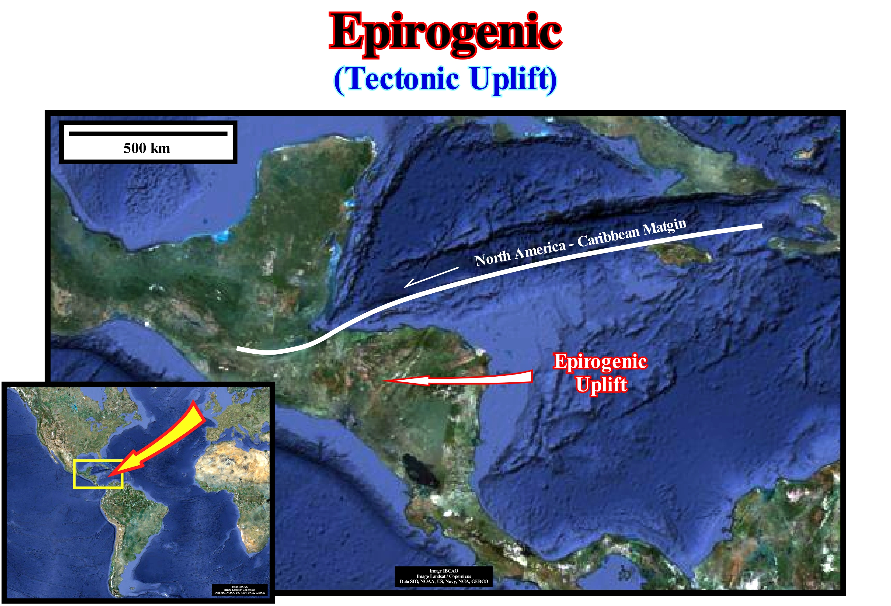
On the Earth's surface, there are certain areas, such as the one illustrated in this figure, that can be explained as the consequence of an epeirogenic uplift. The sediments are not shortened, that is to say, the sediments were not submitted to a compressional tectonic regime (σ1 horizontal). When the sediments are subjected to a compressional tectonic regime, they are shortened and as the minimum effective effort (σ3) is vertical, an uplift is naturally produced. In terms of sequential stratigraphy, it means a relative sea level fall. In general, this type of uplift is associated to the important fracture zones of the oceanic crust. However, before and even after the advent of plate tectonics theory, certain geoscientists have admitted that the Earth's volume since its formation has increased and that the main mechanism has been the epeirogeny. Some authors, such as Owen, G., (1992), think that the Earth's volume, between 200 and 120 million years ago was smaller and that the Earth's radius was 80% of the current radius. Under these conditions, in the reconstitution of the Pangea, the continents fit, perfectly, against each other without any anomaly, that is to say, without the Tethys Sea or Paleoarctic Sea. Owen thinks that the Earth's dimensions were not constant throughout the eons. On the other hand, he also admitted that on the Pacific Ocean active margins, the subduction rate of the oceanic crust is insufficient to satisfy the law of surface conservation of a sphere with constant dimensions. At present, almost all geoscientists admit, not only that the Earth 's volume is the same since its formation, i.e., they admit the gravity has not varied significantly since 4.5 Gy, but also that the water volume. in all its forms, remains constant. Thus, in the reconstructions of the Pangea (Permian-Triassic supercontinent), when the continents are fitted against each other, using the boundaries of the continental shelves as a reference, a great gulf becomes evident in the agglutinated continental mass that the geoscientists call the Tethys Sea.
(*) The effective stresses, i.e., the stresses that, actually, deform the rocks are the result of the combined action of the geostatic pressure (σg), hydrostatic pressure or pore pressure (σp) and tectonic vector (σt), which define a triaxial ellipsoid, in which σ1 is the major axis, σ3 the smallest axis and σ2 the middle axis.
Epirogeny (Epeirogeny)............................................................................................................................................................................................Épirogénie
Epirogenia / Epirogenia / Epirogeny (Tektonik) / Epirogeny 口水 (构造) / Эпейрогения / Epirogeny (Tettonica) /
A form of diastrophism which, according to some geoscientists, produced the great components of the continents and oceans, but which contrasts with the orogenies (more localized process), which produced the mountain chains. The epirogenic movements are mainly vertical and affect large sectors of the continents, not only the cratons, but also the stabilized mountain chains, where they produced the current mountainous topography. Epirogenic structures may become orogenic, but the vast majority strongly contrast. Synonym of Epirogenesis and Epeirogenesis.
See: « Geological Time »
&
« Geological Time Scale »
&
« Orogenesis »
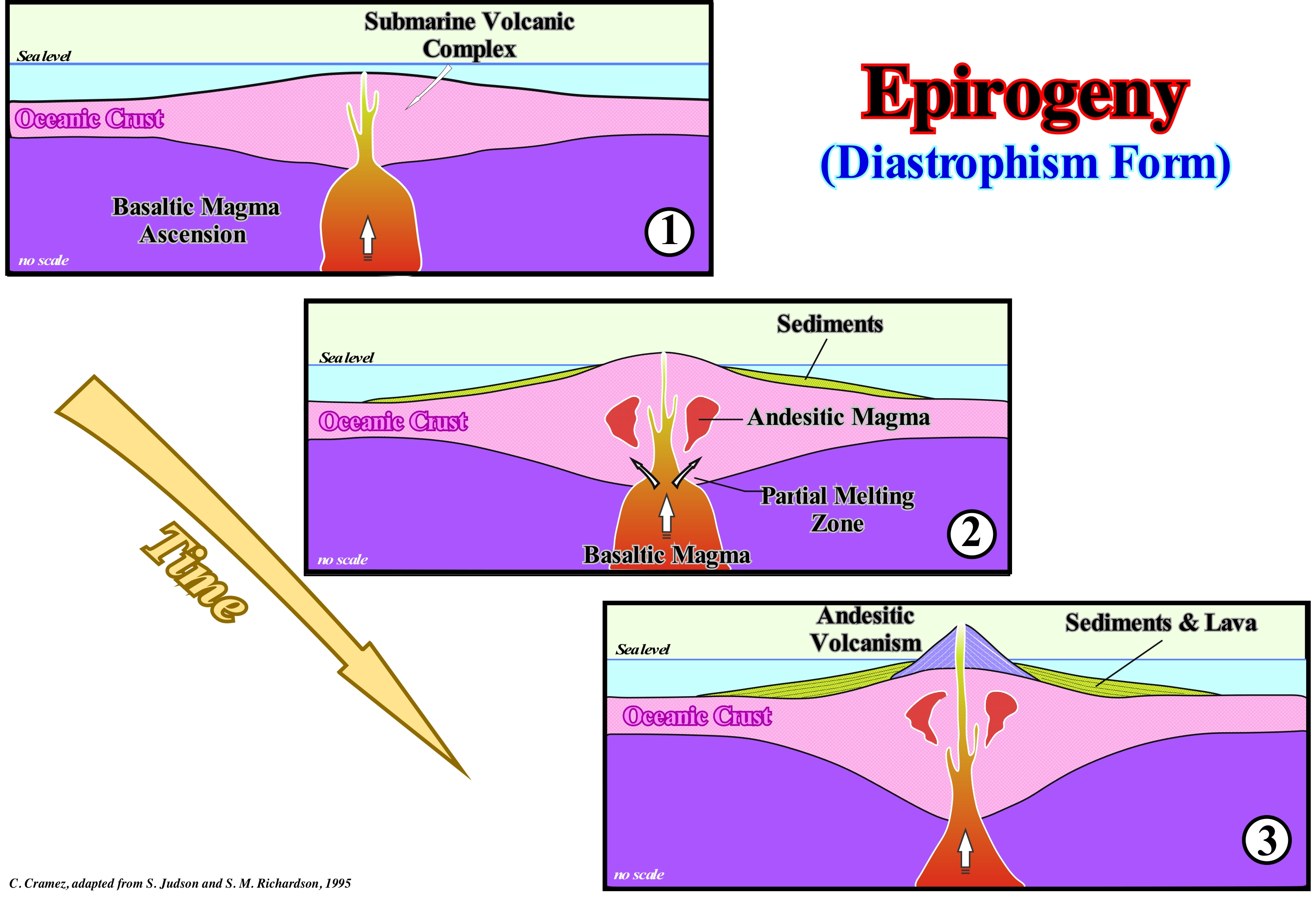
Before the advent of Plate Tectonics theory*, i.e., more or less, when I studied Geology at the Oporto University (Portugal), the theory advanced by most geoscientists to explain certain geological observations was the epirogeny, which, today, was, practically, abandoned. The hypothesis of epeirogenesis suggests that the cratons would have formed from volcanic complexes by vertical movements of the hot spots. As illustrated, the first magmas that would have risen from the mantle were, probably, basaltic (there are three main types of magmas, basaltic, andesitic and rhyolitic**). However, as the crust increased in thickness due to the lava stacking and sedimentary deposits, a partial melting would have produced andesitic magmas (frequent, particularly in the Benioff subduction zones). Over time, the formed continental islands became, little by little, granitic. This hypothesis, which does not involve any movement of tectonic plates in the growth of cratons, can not, of course, be considered exclusive and is, even, contested by most geoscientists. Basically, modern geoscientists, who adopted this theory, admitted that the Earth's volume was never constant, but that, on the contrary, it increased with time. For them, due to the initial increase in Earth's, the original crust fractured and allowed the rise and extrusion, along the fractures, of deep volcanic material. At the same time, the water would be released, progressively, from the mantle to keep the sea level constant. This hypothesis, which implies the force of gravity varied throughout Earth's history, was refuted by a whole series of observation data.
(*) Geological theory that explains how the lithosphere is structured and, in particular, explains in a more satisfactory way: (i) The lithospheric plates, which form the Earth's surface ; (ii) The relative motion between them, their movement on the Earth's mantle, their directions and interactions ; (iii) The formation of mountain ranges (orogens) ; (iv) Why earthquakes and volcanoes focus primarily on certain regions of the globe, such as along the Pacific Ring of Fire ; (v) Why are the large ocean trenches near islands and continents rather than in the centre of the oceans ; (vi) The megasutures, i.e., the moving regions of the Earth (folded and fractured mountain ranges), which testify the complexity of the accretion and deformation phases undergone by geological bodies in regions where compressional tectonic patterns predominate, etc., etc.
(**) Granitic or rhyolitic, magmas and andesitic magmas are generated at convergent plate boundaries where the oceanic lithosphere (the outer layer of Earth composed of the crust and upper mantle) is subducted so that its edge is positioned below the edge of the continental plate or another oceanic plate. Basaltic magmas that form the oceanic crust of Earth are generated in the asthenosphere at a depth of about 70 kilometres. The mantle rocks located at depths from about 70 to 200 kilometres are believed to exist at temperatures slightly above their melting point, and possibly 1 or 2 percent of the rocks occur in the molten state.
Episodic Paracycle.........................................................................................................................Paracycle séquence épisodique
Paraciclo-sequência (episódico) / Paraciclo secuencia episódico / Episodische paracycle / 情节paracycle / Эпизодическая парасеквенция / Paraciclo episodico /
One of the two types of particular sequence-paracycles that can be found in a sequence-cycle. Episodic sequence-paracycles are induced by the Milankovitch orbital cycles. They are, particularly, well visible, especially in the transgressive intervals (TI) of the sequence-cycles.
See: « Fifth Order Eustatic Cycle »
Episutural Basin...................................................................................................................................................................................................Bassin épisutural
Bacia Epissutural / Cuenca episutural / Episutural Becken / 缝合带上的盆地 / Эписутурный бассейн / Bacino episuturale /
A sedimentary basin developed in the interior of a megasuture, such as the backarc basins.
See: « Basin (sedimentary) »
Epoch...............................................................................................................................................................................................................................................................Époque
Época / Época / Epoche (Geologie) / 时代 (地质学) / Эпоха (геология) / Epoca (Geologia) /
Division of geological time shorter than a Period and longer than an Age. Ex: The Neocomian epoch is part of the Cretaceous period.
See: « Geological Time Scale »
&
« Eon »
&
« Geological Time »
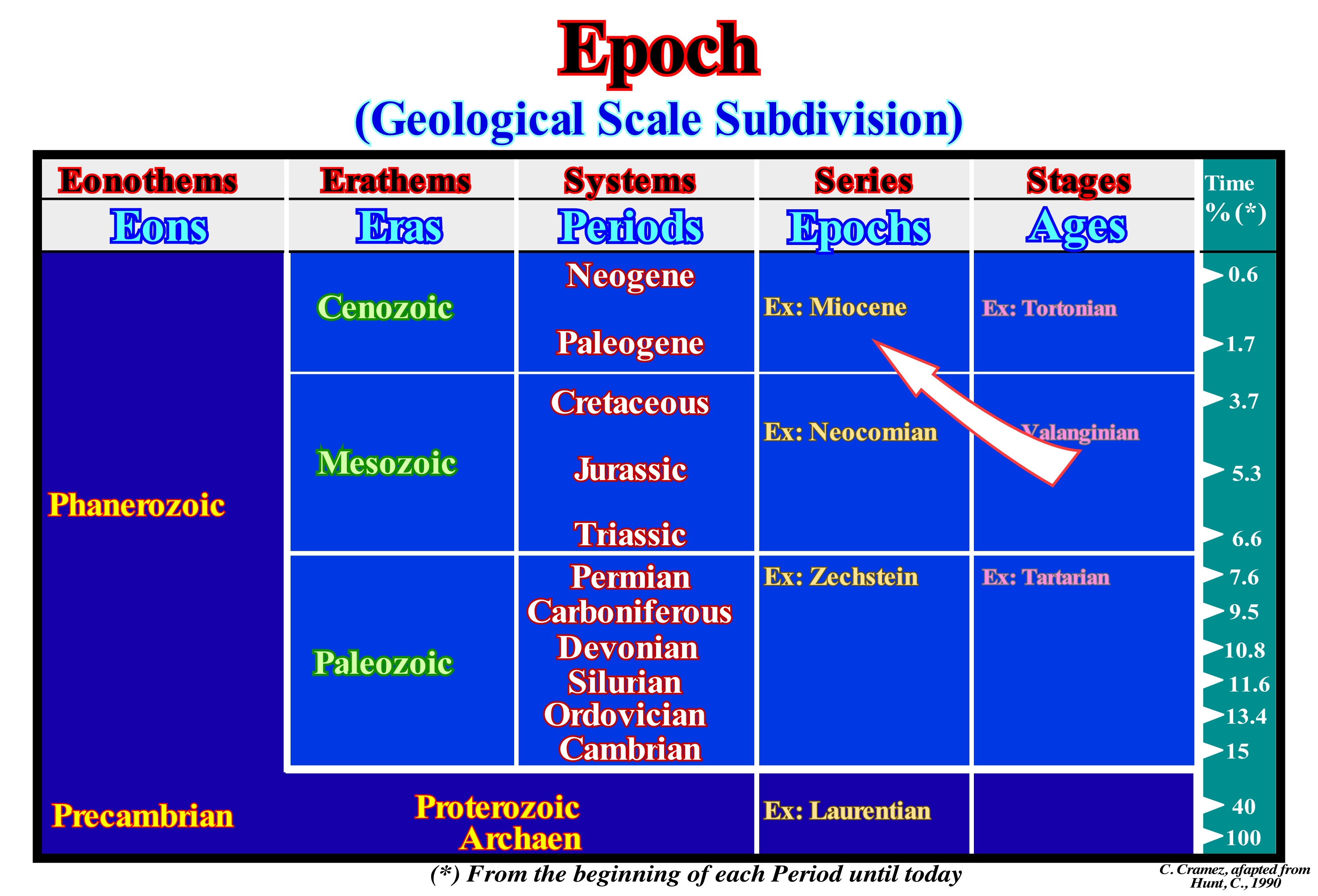
In this geological scale, the last column (Time%) represents the percentage of time from each Period to Today. The Cretaceous represents about 1.6% (5.3-3.7 My) of the total time of Earth's history, i.e., from the beginning of the Archaeozoic (which can be divided into Hadean and Archean). The Cretaceous rocks form three series: (i) Neocomian; (ii) Gallic and (iii) Senonian. The Neocomian series was introduced by Jules Thurman (1835) from the outcrops of Neuchâtel (Neocomum) in Switzerland. In the type region (Neuchâtel), the rocks were divided in two sub-stages: (a) Valanginian, formed by the rocks that appear along the throat of the river Seyon, near the village of Valangin and (b) Hauterivian, formed by the rocks that appear between the villages of St. Blaise and Hauterive. Some authors, like Coquand (1876), still consider a sub-stage, local, called Infra-Valanginian or Berrisian. It was during the Neocomian that the supercontinent Pangea lengthened by the formation of the rift-ype basin and later fractured into different continents, which now occupy a very different position. The fracturing and individualization of the continents was not synchronous. In the Gondwana (southern small supercontinent of Pangea), for example, oceanization was done from the south to the north. That means that when the South Atlantic Ocean, off the coast of Angola, was already quite wide, to the north, near the present Gulf of Niger, the break-up of the lithosphere had not yet taken place. It was also in the Neocomian period that the first flowering plants appeared. Probably, during the Neocomian, the angiosperms were not very important. They began to be part of the flora and became dominant at the end of the Cretaceous. The development of the flowers led, immediately, to their coevolution with the insects. At the beginning of the Cretaceous, we began to see specialized pollinators evolve from several clades (group of organisms originating from a single common ancestor) of insects. It was in the Neocomian era that mammals evolved in placental and marsupial clades.
Equilibrium (State).........................................................................................................................................................................................................Équilibrie
Equilíbrio / Equilibrio / Equilibrium, Gleichgewicht / 平衡 / Равновесие / Equilibrio /
Condition of a system in which competing influences are balanced.
See: « Systems' Theory »
&
« Equilibrium Point »
&
« Provisional Equilibrium Profile »
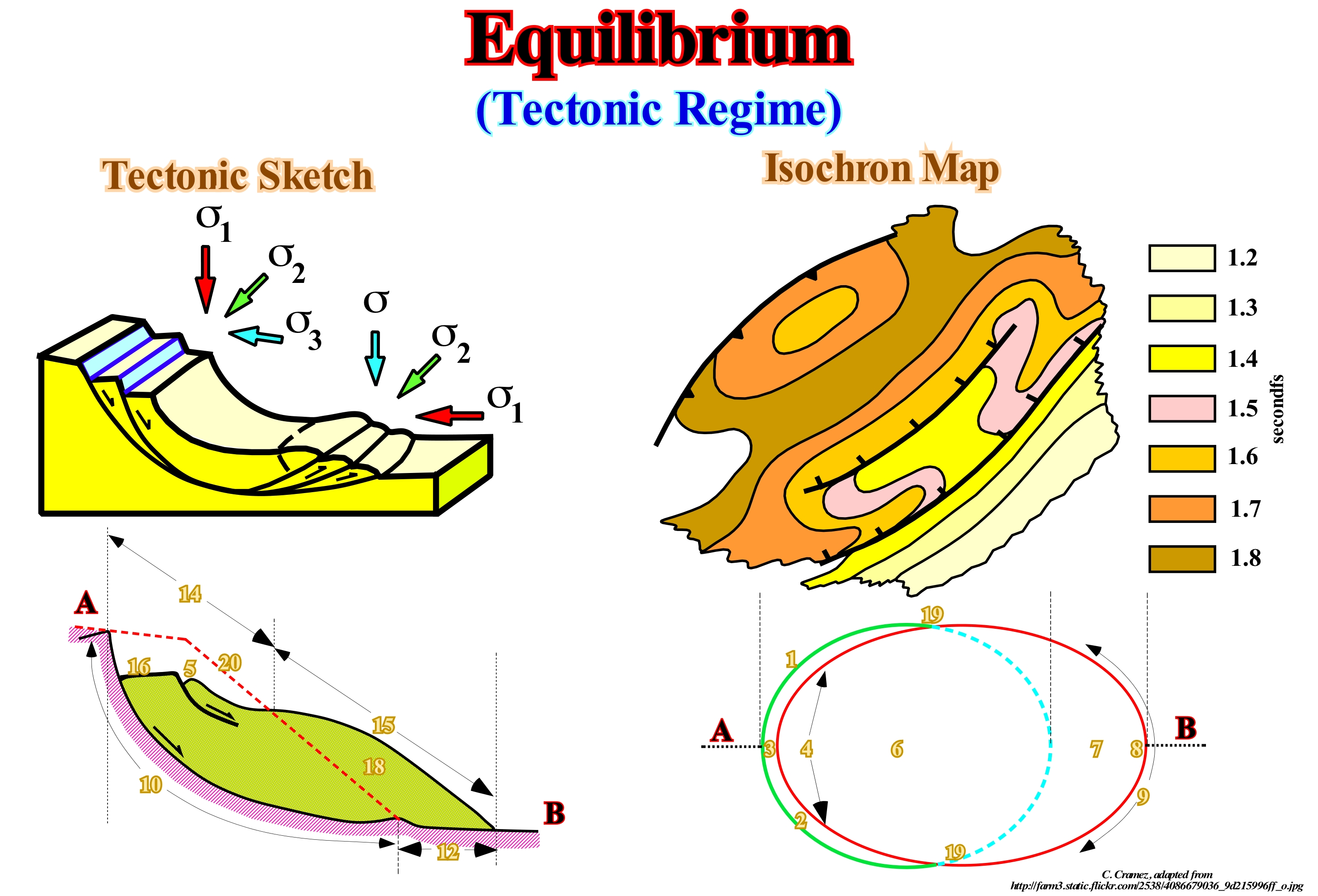
The equilibrium state in any system depends on factors present in the system, such as temperature, pressure and concentration of several species. These factors are called variables or reaction parameters. A change in any of the parameters can affect the position of the equilibrium. The general rule that can explain the effect of changes in these parameters on the equilibrium state was formulated by H. Le Chatelier (1885), Braun and F. (1886). It is called the Le Chatelier principle, which can be applied in almost all branches of science. The example illustrated in these sketches shows the formation of normal listric faults, which often develop near the continental edge (whether or not corresponding to the basin edge), in order to balance the system provided that one or more of the factors of the system has varied. If we consider the progradation of the depositional coastal break of the depositional surface of a delta (± the delta front), as the relative sea level rise in deceleration (regression), everything happens, normally, until the critical angle of stability of the prodelta (delta slope). The delta progresses, quietly, basinward. However, as long as the critical angle of the prodelta is reached or if for some other reason, geological or meteorological, the equilibrium of the depositional coastal break is broken, locally, an extensional tectonic regime develops. This tectonic regime, characterized by an ellipsoid of effective stresses with vertical σ1, σ2 parallel to the direction of the prodelta and σ3, more or less, perpendicular, creates a number of normal faults that horizontalize in depth and basinward. The sedimentary lengthening (extension) created by this extensional tectonic regime is balanced by the development of a more distal, but, practically, synchronous (in geological terms), compressional tectonic regime. This local tectonic regime is characterized by an ellipsoid of the effective stresses with σ1 horizontal and perpendicular to the line of the shoreline, σ2 parallel to the direction of the prodelta and σ3 vertical. This regime shortens the amendments that have slid downward, which allows to balance again the depositional system.
Equilibriun Line (Glacier)...................................................................................................................................Ligne d'équilibre (Glacier)
Linha de equilíbrio / Línea de equilibrio (glaciar) / Equilibrium Linie (Gletscher) / 平衡线(冰川) / Граница питания ледника / Linea di equilibrio (ghiacciaio) /
Line, which on a glacier, separates the accumulation zone from the ablation zone.
See : « Glacier »
&
« Accumulation Zone (glacier) »
&
« Firn »
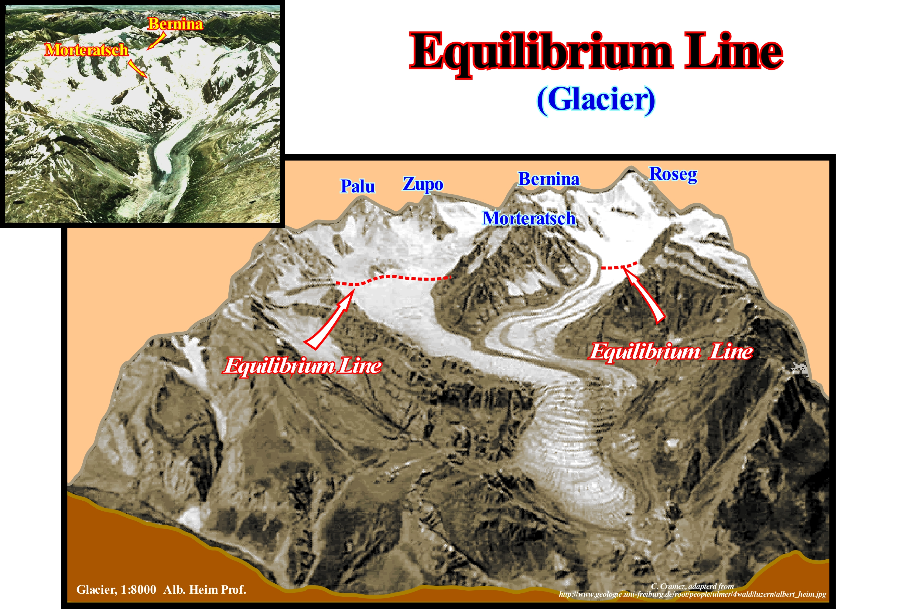
In this model, in plaster, of a glacier (Geology Institute of Neuchâtel, Switzerland) the Tschierva glacier, with the Bernina peak (4049 m) on the right and the Roseg (3937 m) on the left, it is well seen that glacier functions as a bank account, with deposits and withdrawals. The deposits are the layers of snow, which fall all the winters. The withdrawals are the losses of millions of litres of water every summer, either by runoff or by evaporation. A glacier in good health retains a large part of the snow that has fallen, in the winter, on top, in the form of ice, while the snow at the bottom is lost by melting and evaporation. All this means that in a glacier there are two fundamental zones: (i) Accumulation Zone, where the snow is retained in the form of ice and (ii) Ablation Zone, where it melts more ice than it accumulates. It is the boundary between these two zones, which is called the equilibrium line, which is, usually, measured in altitude. Glaciologists determine the health of a glacier, i.e., whether it is thickening or thinning, by calculating the relationship between the area of accumulation and the total area of the glacier. The higher the ratio of the surfaces, the greater the accumulation and the better the glacier (the more significant is the relation between the volumes, since in some cases the ratio increases and the glacier can retrograde). The equilibrium line is difficult to observe, directly, but relatively easy to calculate. The equilibrium line should not be confused with either the snow-line (lower limit of the snow cover last winter) or the firn-line, which is the limit of the snow surface, which survived the ablation for a year. In the absence of ice overlapping (ice on the glacier, which formed from the melting of the snow after deposition and which is, usually, below the snowline and above the equilibrium line), the firn-line is equivalent the equilibrium line. In certain glaciers in summer, these two lines are very clear. The equilibrium line is light-coloured, and a few meters lower, with a dark colour the snow-line from the previous year (firn-line). Do not forget that a glacier is like a current of ice. It only exists as long as there is flow. If ablation is greater than accumulation, the glacier continues to flow, downhill, but thinning.
Equilibrium Point..........................................................................................................................................................................Point d'équilibre
Ponto de equilíbrio / Punto de equilibrio / Gleichgewichtspunkt / 平衡点 / Точка равновесия / Punto di equilibrio /
Point of a depositional surface where the rate of eustatic variation and subsidence are equal and compensate for their effects. The equilibrium point separates an area subject to a relative sea level fall of another, at downstream, subject to relative sea level rise.
See: « Relative Sea Level Change »
&
« Eustasy »
&
« Subsidence »
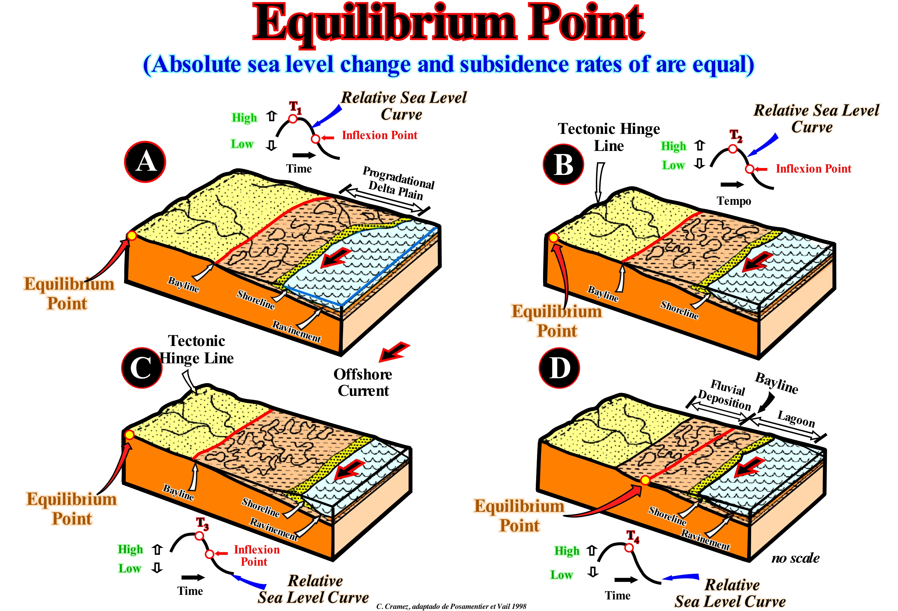
Posamentier and Vail (1988) defined the equilibrium point as the point of a divergent margin in which the available space for sediments (accommodation), induced by tectonics and by absolute (eustatic) sea level change compensate themselves. That means at that equilibrium point the relative sea level is stable. The accommodation can be positive or negative. Its is positive when there is subsidence of the sea floor, i.e., when the sediments are lengthened by a predominant extensional tectonic regime. It is negative, when there is an uplift of the sea floor, i.e., mainly when the sediments are shortened by a compressional tectonic regime. To avoid confusion, remember that the sea level can be absolute (eustatic) and relative. The eustatic or absolute sea level is global and referenced to the Earth's centre. The relative sea level is local and referenced to the base of the sediments (top of the continental crust) or to any other point on the Earth's surface, such as the sea floor. The absolute (eustatic) sea level is a function of: (i) Tectono-Eustasy that is controlled by the volume variation of the ocean basins ; (ii) Glacio-Eustasy, which is controlled by the variation of ocean water volume as a function of the amount of ice ; (iii) Geoidal-Eustasy which is controlled by the distribution of ocean water caused by variations in the terrestrial gravity field and (iv) Thermal expansion of the oceans or steric sea level rise (if the temperature of the oceans increases, the density of the water decreases and, for a constant mass, the volume increases). The relative sea level is the result of the combined action of absolute (eustatic) sea level and tectonics (subsidence or uplift of the sea floor). As the relative sea level rises or falls, the equilibrium point moves, respectively, to the mainland or the seaward. Upstream of the equilibrium point, the available space for the sediments decreases and there is erosion. Downstream of the equilibrium point, the available space increases and, therefore, there is deposition. The diagrams shown in this figure emphasize the response of the bayline and coastal environments to the equilibrium point displacement when the relative sea level changes. If the relative sea level falls, but not enough to change the geological conditions to lowstand, the equilibrium point moves downstream. It may happen, that at certain moment, the equilibrium point approaches the bay-line and even coincides with it. Under such conditions, the equilibrium point will be the limit between the fluvial deposits and the coastal plain, where relative sea level change control the available space for the sediments. In this model, with which not all geoscientists agree, the bayline marks, always, the limit between the alluvial and coastal plain, i.e, that it is from the bay-line that the provisional equilibrium profile of the rivers becomes, more or less, horizontal or, in other words, it is from the bay-line that the provisional equilibrium of the water-courses becomes, more or less, horizontal (the transport capacity of the streams decreases and deposition starts). It is with this concept that certain geoscientists do not agree. For them the loss of charge of the water-courses is, mainly, at the mouth of the streams and not at the bay-line. Posamentier and Vail (1988) think that deltaic deposition occurs when a current encounters a waterbody, almost, immobile and its velocity decreases almost instantaneously : (i) The coastal plain is formed by sea floor progradation, more than by exhumation ; (ii) The sediments that accumulate in the coastal plain during the shoreline progradation construct what they called "coastal wedge or coastal prism", which includes fluvial and shallow-water deposits ; (iii) The wedge-shaped coastal prism extends continentward by onlapping by on the pre-existing topography ; (iv) The upstream limit of the coastal wedge is the bay-line, which may move upstream when the progradation of the shoreline is accompanied by aggradation ; (v) The bayline is the limit between the coastal and alluvial plains ; (vi) Upstream of the bayline, relative sea level changers have no influence on depositional systems. Although the bayline may, in very particular cases, coincide with the line passing through the equilibrium point, in spite of the fact that these two geological concepts are quite different.
Equilibrium Theory (Meanders).......................................................................................Théorie de l'équilibre (Méandres)
Teoria do equilíbrio / Teoría de equilibrio (meandros) / Gleichgewichtstheorie (Mäander) / 均衡理论(河曲) / Теория равновесия (меандры) / Teoria del equilibrio (meandri) /
This theory says that meanders formation decreases the flow gradient of the stream (slope) until the balance between the erosion of the terrain and the current carrying capacity is reached. The descending water mass abandons potential energy (energy associated with the force of gravity) which is removed by the interaction of the flow with the bed material of the stream, since the velocity of the stream is the same at the beginning and at the end of the path.
See: « Meander Belt »
&
« Oxbow »
&
« Point Bar »
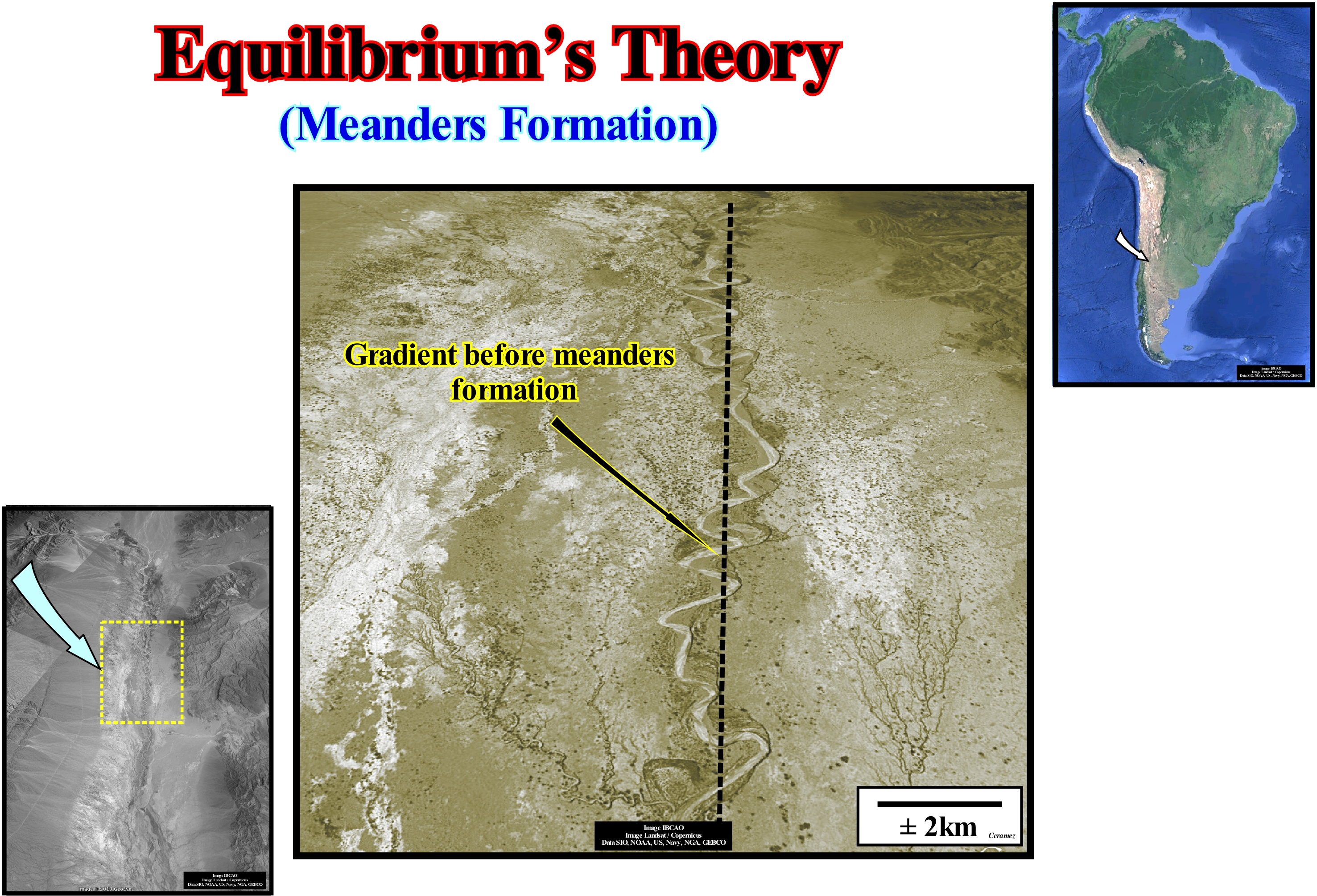
A meander is a sharp curve of a river that occurs, particularly, in its alluvial plain. It changes shape and position with variations of greater or lesser energy and fluvial load during the seasons. The meanders are common in alluvial plains, but occur, more narrowly, in other conditions as on horizontal sedimentary terrain (valley meanders). The channel of a river changes, constantly, position along the alluvial plain, through a process, more or less, continuous of erosion and deposition along its banks. For that a meander is, often called, a free meander or free swinging meander. The outer margin of a meander (the centrifugal margin of water-course) presents ravines that are, progressively, eroded. In the inner margin deposition, mainly, of sand occurs. This process accentuates the curvature of the meander that ends up forming an entire loop creating a truncation at a point where the fluvial current change its trajectory, leaving the old meander abandoned and closed with a U-shaped lake that many geoscientists call the lake of abandoned meander lake or oxbow lake. Three theories were advanced to explain the meanders formation (https://es.wikipedia.org/wiki/Meandro#Teor.C3.ADa_del_quilibrio): (i) Stochastic Theory ; (ii) Geomorphological or Morphotectonic Theory and (iii) Equilibrium Theory. In stochastic theory, as its name implies, a meander is interpreted as the result of occasional fluctuations (depending on chance and on which it is only possible to speak of probabilities) in the direction and direction of the runoff, due to the presence of obstacles in the bed of the watercourse. Geomorphological or Morphotectonic theory considers that geological structures, as folds, faults, etc., are the main responsible for the formation of the meanders. In equilibrium theory, the meanders decrease until the current gradient reaches an equilibrium between the ground erosion and charge capacity of the current (both water and deposits). A descending mass of water must renounce the potential energy* that it had. It has the same velocity at the end as at the beginning. The potential energy is eliminated by interaction with the bed material. The smaller the distance between two points, that is, a rectilinear channel, gives the highest energy results per unit length, which alters more the channels, creating more sediments and greater higher will be the sedimentary aggradation induced by the current (silting). The presence of meanders along the trajectory of a water-course allows to adjust the length to reach an energy equilibrium per length unit so that the current carries all the sediment it produces. This theory explains in a satisfactory way why there are more meanders in the upstream sector of certain water-courses, as illustrated in this example (South America). The gradient of the current is far from equilibrium between erosion and current charge capacity. In stochastic theory, the meanders are assumed to be the result of stochastic fluctuations in the direction of flow due to the presence of random changes in the direction of the obstacles in the course of the river. However, in an area of low slope, river flow can create whirlwinds and meanders that are not always due to chance. The meanders to the left are predominant in the Northern Hemisphere. In the Southern Hemisphere, the meanders to the right predominate. This is due to Earth's clockwise rotation in the southern hemisphere, because of proper rotation of Earth. On surface, the erosion acts in different ways depending on the slope and the constitution of the ground. The result of all the physical factors that act, at random, creates progressively rectilinear trajectories, and then become sinuous. In geomorphological or morphotectonic theory, it is the ground surface structure and tectonics that guide the flow of rivers in nonrandom ways. They are the predictable obstacles that instigate the formation of meanders to divert the flow. For example, a sandbank (geomorphological) could deflect the current, causing or deflecting the meander pattern, or the current can be guided by the existence of a fault (morphotectonic).
(*) Stored energy that depends upon the relative position of various parts of a system. A spring has more potential energy when it is compressed or stretched. A steel ball has more potential energy raised above the ground than it has after falling to the Earth. In the raised position it is capable of doing more work. Potential energy is a property of a system and not of an individual body or particle. The system composed of the Earth and the raised ball, for example, has more potential energy as the two are farther separated.
Equinox................................................................................................................................................................................................................................................Équinoxe
Equinócio / Equinócio / Äquinoktium / 晝夜平分點 / Равноде́нствие / Equinozio /
Moment of the year in which the Sun is located in the plane of the celestial equator (at that moment, for a person in the terrestrial equator, the Sun is at the highest point of the sky above his head, i.e., at 90 °). Point in Earth's orbit, where the inclination of the axis of Earth's rotation is such that the sun's rays are perpendicular to the equator (the Sun is at the zenith on the equator). The term equinox, which comes from Latin ("aequus" - equals and "nox" -night) means "equal nights," meaning that an equinox is the time when day and night last the same time.
See: « Milankovitch's Cycle »
&
« Astronomic Theory of Paleoclimate»
&
« Equinoxial Precession »
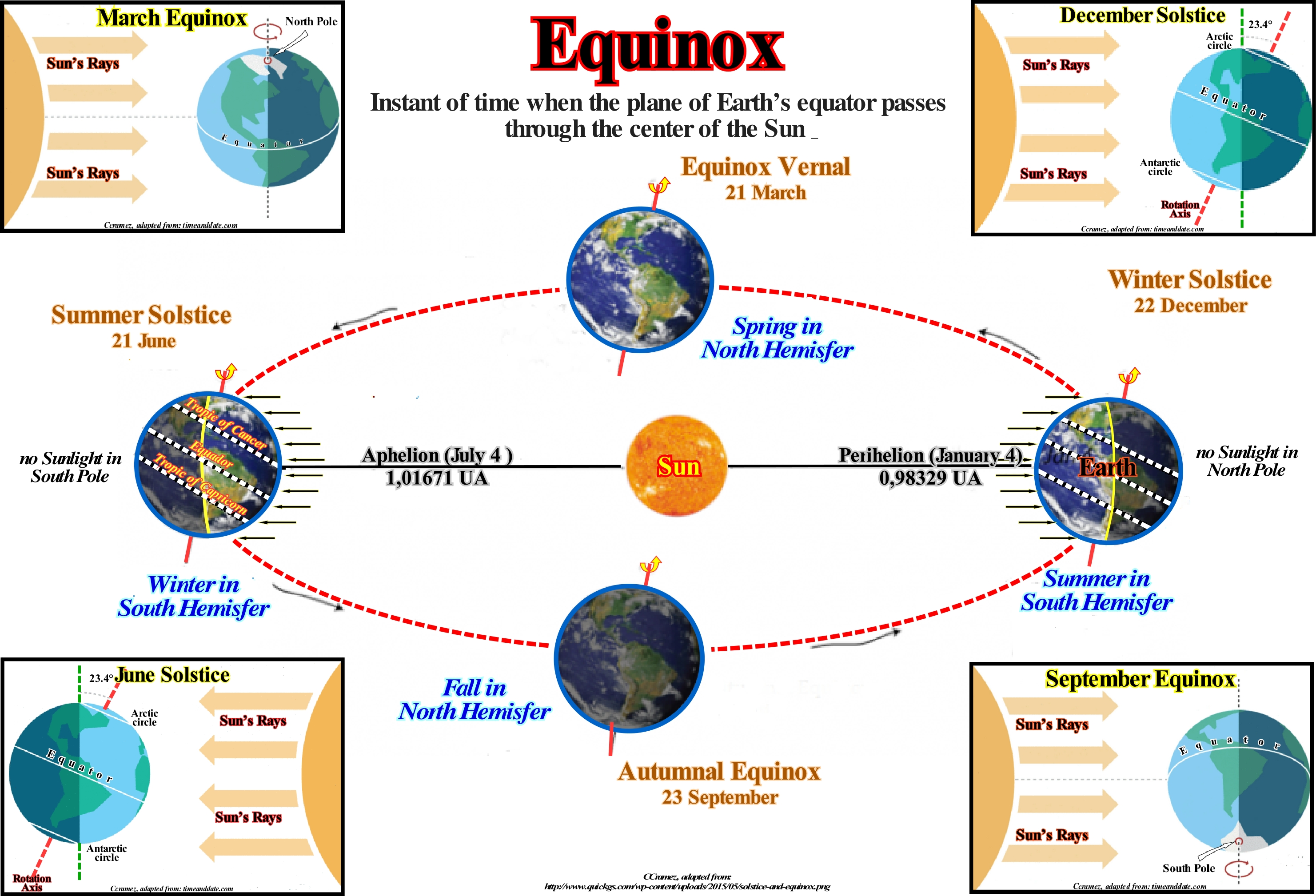
At equinox the nights are equal to the days. The period of insolation is equal to the period without solar illumination. There are two equinoxes a year. They mark the beginning of spring and autumn (about 21 March and 20 September in the Northern Hemisphere). On an equinox the Sun crosses the celestial equator. On the equinox of March, the Sun passes from the Southern Hemisphere to the Northern Hemisphere. At the astronomical point of view, an equinox is when the Earth is located in one of the nodes of its orbit, that is, one of the two intersections between the orbit and the plane of the ecliptic. The axis of the Earth is inclined about 23° in relation to the orbit plane. During half of the year, the Earth's northern hemisphere is tilted towards the Sun, while the orientation is in favour of its southern hemisphere during the other half. During an equinox, the two hemispheres are equally facing the Sun, which is located directly above the equator. The North and South poles are, also, situated at that moment on the equator. Day and night divide, exactly, the two hemispheres. From the geocentric point of view, an equinox occurs when the Sun reaches one of two intersections between the ecliptic and the celestial equator. Its declination* is at that moment zero. The Sun is not a single point of light seen from Earth. The total time for it to remain above the Equator is reached in 33 h. The date of the equinox can be determined by observing the sunrise **, in relation to the point all the East (or from the point west of the sunset). The spring equinox occurs on the day the Sun ceases to rise south of that point, to rise to the north (mutatis mutants for sunset, and/or for the autumnal equinox). The exact moment can be appreciated from the solar azimuth in two consecutive sunrises, interpolating the moment where the sun passes at 90° azimuth (or 270° for sunset). It is often said at the equinox, the Sun rises to the East and sets to the West, but this is only approximately correct. This rule does not take into account the movements of the Sun during the day. The Sun can not rise, exactly, to the East, just if it rises at the exact moment of the equinox, which is the case along a meridian, but at the time that the Sun sets, twelve hours later, its declination will have varied slightly (one-fifth degree). So he will not set, exactly, to the West. However, the difference is not very sensitive for a current observation: about a third of azimuth degree, for latitudes of the order of 45°.
(*) The declination of a star is the arc of the star's meridian defined between the plane of the celestial equator and the star. It can be compared to the latitude in the geographic coordinates system. By projecting a person's position on the Earth's surface on the celestial sphere, its angle to the celestial equator is equal to its latitude and will be equal to the declination of a star in the celestial sphere this position.
(**) The aurora is for many geoscientists the period of light without the sun rising.
Equinoxial Precession............................................................................................................................Précession des équinoxes
Precessão dos equinócios / Precesión de los equinoccios / Präzession der Tagundnachtgleiche / 昼夜平分点岁差 (天文) / Предварение равноденствий / Precessione degli equinozi /
A consequence of the precession of the axis of Earth's rotation as the intersection of the elliptic with the celestial equator advances along the equator, which produces, approximately, twenty seconds of difference per year between the terrestrial calendar and the celestial calendar.
See: « Astronomic Theory of Paleoclimate»
&
« Milankovitch's Cycle »
&
« Precession »
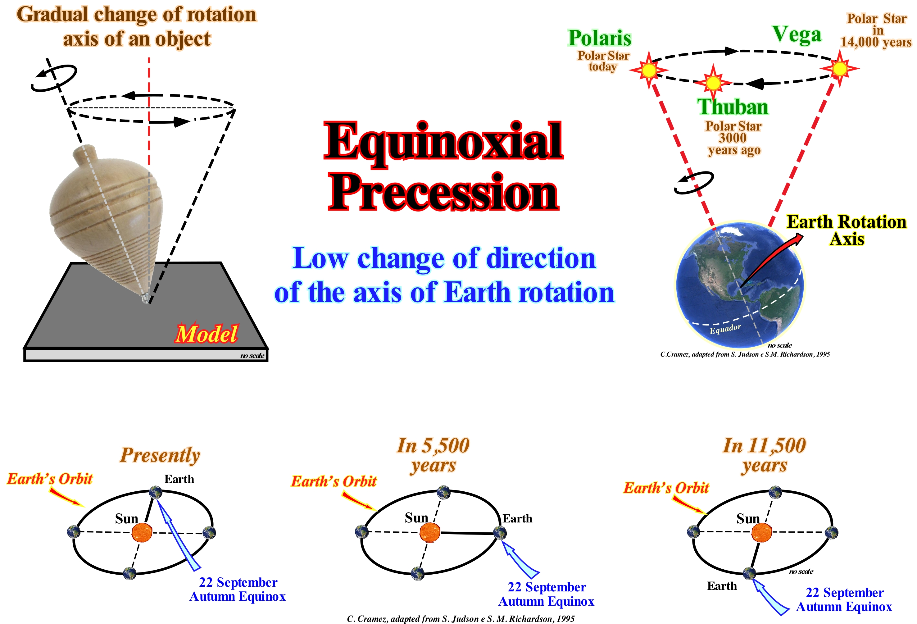
First of all, do not forget that in astronomy: (i) An equinox, which in Latin means equal nights, is defined as the moment in which the Sun, in its apparent orbit, that is to say, as seen from Earth, crosses the celestial equator, i.e., the projected Earth's equator line in the sphere or celestial vault (the firmament where all the objects visible in the sky can be projected) ; (ii) A solstice, that in Latin signified stopped, is the moment in which the Sun, during its apparent movement in the celestial sphere, reaches the greater declination (arc of the meridian of the Sun between the plane of the celestial equator and Sun) in latitude, measured from the equator line or, more simply, when the Sun is at the farthest angle from the equator. The equinoxes occur during the months of March and September, when sunlight falls on the northern hemisphere and on the southern hemisphere. Solstices occur twice a year, in December and June, when Earth receives more solar energy on one hemisphere. The exact day and time of solstices vary from year to year. Milankovitch has assumed that the main parameters controlling the solar radiation received by the Earth's surface and thus the climate of our planet are: (a) Precession of the axis of rotation of the Earth ; (b) The obliquity of the Earth's orbit ; (iii) Precession of the Earth's orbit and (iv) Eccentricity of the Earth's orbit. On this subject, the ideas of G. Gamov (1956) can be summarized as follows: 1) The axis of rotation of the Earth moves slowly in space ; 2) The axis of rotation of the Earth describes a cone whose axis is perpendicular to the plane of the Earth's orbit ; 3) The motion of the Earth's axis is known as the precession of the equinoxes ; 4) Newton explained that precession is the result of the attraction of the Sun and the Moon to the equatorial plane of the Earth ; 5) Precession is a very slow movement and the axis of the Earth makes a complete rotation all 26,000 years ; 6) The phenomenon of precession reverses, periodically, every 13,000 years ; 7) In addition to ordinary precession, there are other disturbances of the earth's motion ; 8) The perturbations of the Earth's motion due to the influence of the planets, particularly Jupiter ; 9) These disturbances are added to the precession ; 10) The inclination of the axis of rotation of the Earth in relation to the plane of the orbit, which does not affect ordinary precession, exhibits periodic variations of about 40,000 years ; 11) Earth's orbit changes ; 12) The Earth's orbit rotates very slowly around the sky and its eccentricity increases and decreases periodically ; 13) The periods of these changes are 60,000 and 120,000 years ; 14) The rotation of the Earth's orbit has the same consequences as precession, its effects can be added ; 15) A super-period of the eccentricity of about 400,000 years is known ; 16) Periods of eccentricity change have a great influence on the climate of the Earth's surface ; 17) During periods of great elongation, the Earth at the end of its trajectory is very far from the Sun and thus both hemispheres receive abnormally low amounts of heat, which, of course, implies cold periods and climate. As illustrated, at present, the Polar star* indicates, roughly, the Earth's north pole. Due to its alignment with the axis of rotation of the Earth, the polar star is seen as motionless to an observer on Earth. The other visible stars seem to describe a circular motion around the polar star at night. However, as illustrated in this figure, about 3,000 years ago was the Thubam star, which indicated the North Pole and hence, about 14,000 years, will be Vega star that will indicate the North pole. The Thubam star is a star or star system of the Dragon constellation which is one of the 88 constellations of the sky, the eighth in size and consisting of a long line of stars along a part of the Ursa Minor (Little Bear), which despite its length, has no bright star. The Vega star is the brighter star of the constellation Lyre that is the fifth star bright of the sky and that is separated from our solar system by 25 light years, that is, 25 x 9 460 730 472 580.8 km, which means that is one of the stars closest to the Earth. A complete equinox shift or precession cycle takes place every 23,000 years. If the position of the Earth in its orbit around the Sun at the autumn equinox (22 September) is, currently, at the "North" of the Sun. Within about 5,500 years it will be the "East" and within 11,500 years it will be to the South, i.e., in a position opposite to the one that the Earth occupies presently.
(*) A polar star is, usually, in astronomy, a star visible to the naked eye, being, approximately, in alignment with the axis of rotation of a planet, especially the Earth. Currently, the Polar Star in the Earth's Northern Hemisphere is Alpha Ursae Minoris (α UMi) 1, the brightest star in the constellation Ursa Minor. In the Southern Hemisphere, it is assumed that the Beta Hydri star of the Hydrus constellation, whose apparent magnitude is easily perceived, is a better candidate than Octantis Sigma (σ Oct), which is closer to the axis of rotation of the Earth, is more difficult to detect (https://fr.wikipedia.org/wiki/Étoile_polaire).
Era.......................................................................................................................................................................................................................................................................................Ère
Era / Era / Zeit / 时代 / Эра / Era /
Division of geologic time shorter than the Eon and greater than a Period. The Paleozoic Era, for instance, is in the Phanerozoic and includes, among others, the Devonian Period.
See: « Geological Time Scale »
&
« Eon »
&
« Geological Time »
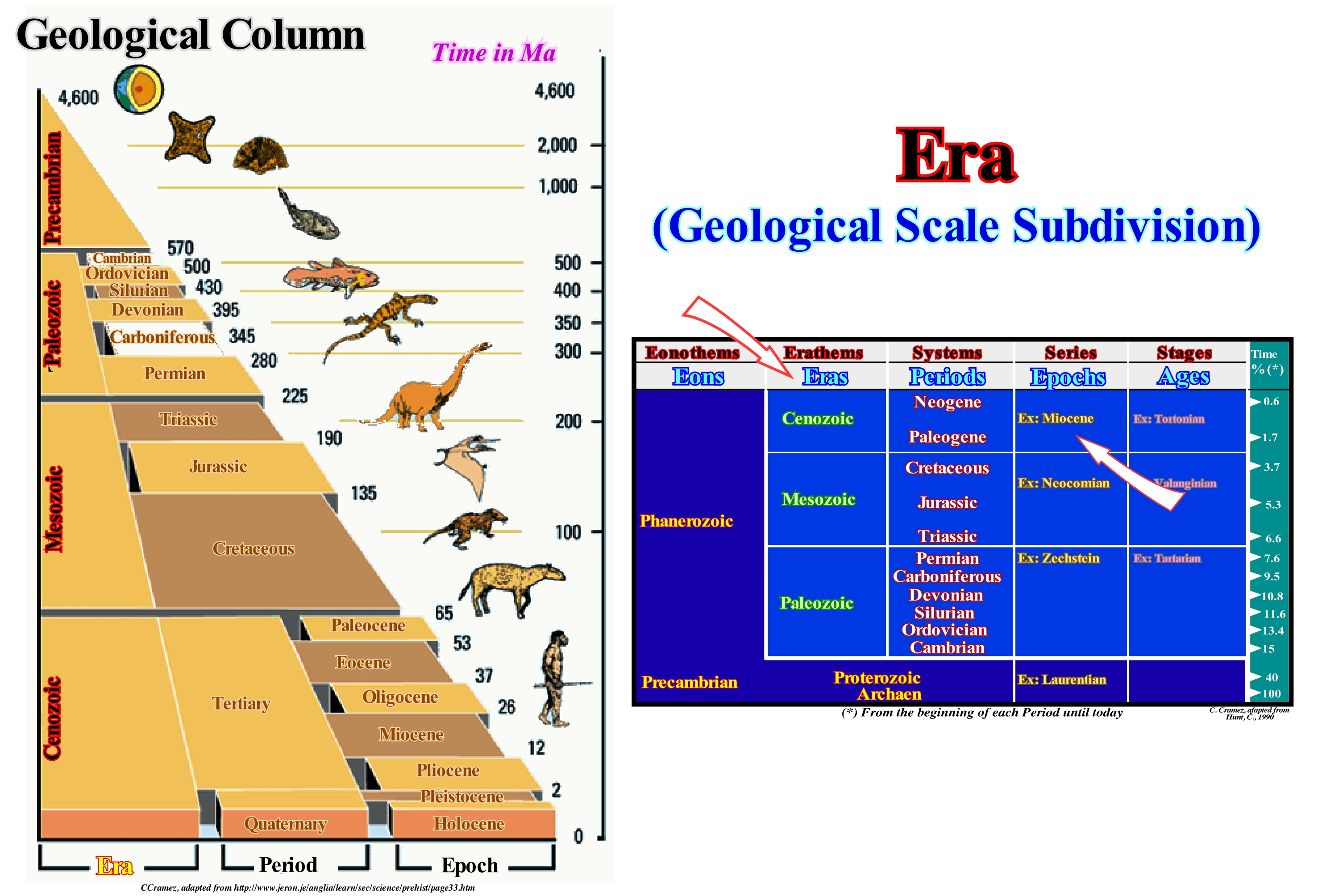
The Paleozoic period corresponds to about 7.4% of the Earth's age (4.5 Ga), that is about 346 Ma. The Paleozoic is formed by six periods (geochronological unit or time unit): (i) Cambrian ; (ii) Ordovician ; (iii) Silurian ; (iv) Devonian; (v) Carboniferous and (vii) Permian. The rocks that form these systems (stratigraphic units) were deposited in association with the first order eustatic cycle of the Phanerozoic (time duration > 50 My). They form the post-Protopangea (Pre-Cambrian) or Rodhinia continental encroachment cycle. In the continental encroachment cycles two major sedimentary phases can be evidenced: (a) Transgressive phase, at the base, and (b) Regressive phase. The transgressive phase is created by the eustatic sea level rise induced by the dispersion of the continents formed by the supercontinent break-up. The formation of oceanic mountains (oceanic ridges) decreases the volume of the ocean basins (assuming that the volume of water is constant since the formation of the Earth). The regressive phase, on the other hand, is created by the eustatic sea level fall (do not confuse eustatic sea level fall with relative sea level fall), induced by the aggregation of the continents to form a new supercontinent. The aggregation of the continents cause a decrease of the volume of oceanic basins due to the subduction of the oceanic crust or due to the collisions between the continents). Overall, the regressive phase has a retrogradational geometry (increase of the deposition water-depth). The regressive phase has a progradational geometry (decrease of the depth of the deposition water-depth). The limit between the two phases corresponds to the eustatic maximum during which, in general, the geological conditions are favourable to the deposition of marine shaly rocks rich in organic matter (potential source-rocks). No geoscientist is surprised to find: (i) Silurian marine source-rocks in association with a major downlap surface ; (ii) A predominance of marine rocks in the basal depositional systems of the Paleozoic ; (iii) A predominance of paralic (deposited upstream of the coastline) and non-marine rocks since the Devonian since a or to find depth of depositional waterdepth decreases.
Erathem............................................................................................................................................................................................................................................Érathème
Eratema / Eratema / Erathem / 界 / Эратема / Eratema /
Chronostratigraphic equivalent of an Era. An erathem is composed of a group of systems. The names of the erathems were chosen to highlight the great changes in the development of life on Earth: (i) Paleozoic (ancient life) ; (ii) Mesozoic (intermediate life) ; (iii) Cenozoic (recent life).
See: « Geological Time »
&
« Era »
&
« Eonothem »
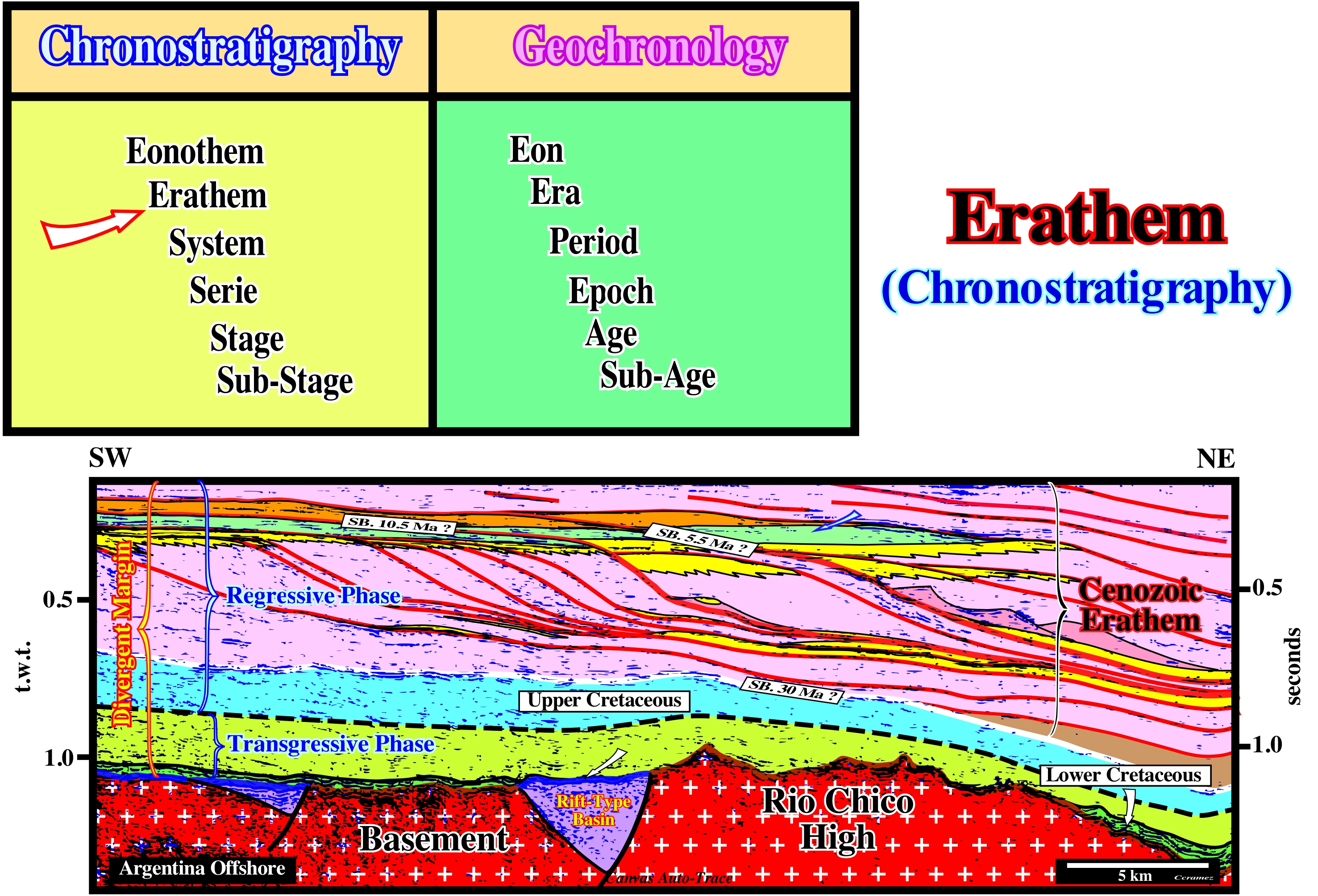
In this figure are represented the chronostratigraphic units ,i.e, the sets of rocks, that were deposited during the geochronological units (geologic time). In the geological history of the Phanerozoic three great eras are considered: (i) Paleozoic; (ii) Mesozoic and (iii) Cenozoic, which are represented by stratigraphic units (set of rocks) that form three erathems (Paleozoic, Mesozoic and Cenozoic). As during the Phanerozoic there were only two first order eustatic cycles and not three. There are just two supercontinents: (a) Proto-Pangea (Rodhinia)at the end of the Precambrian and (b) Pangea at the end of the Paleozoic. In sequential stratigraphy, many geoscientists prefer to consider two erathems: (i) Paleozoic and (ii) Meso-Cenozoic. The Meso-Cenozoic erathem corresponds to the post-Pangea continental encroachment cycle, which was induced by a 1st order eustatic cycle (duration time greater than 50 My) created by the dispersion and agglutination of the continents resulting from the Pangea break-up. Assuming that the amount of water in all its forms (liquid, solid and gaseous) has been constant since the Earth formation (about 4.5 Ga), the volume of the ocean basins increases during the dispersion of the continents (formation of the ocean ridges) and therefore the absolute (eustatic) sea level rises*. On the contrary, absolute sea level falls when collisions between lithospheric plates and the subduction of the oceanic crust increase the volume of the ocean basins. This means during the transgressive phase of the Meso-Cenozoic, the predominant rocks are marine, whereas during the regressive phase, i.e, from the Cenomanian-Turonian maximum flooding surface, with which are associated the potential marine source-rocks, the predominant rocks are paralic (deposited near the coastline) and non-marine. The transgressive phase has a retrogradational geometry and the regressive phase has a progradational geometry.
(*) The absolute (eustatic) sea level, which is global and referenced to the Earth's centre, is a function of: (i) Tectono-Eustasy (variation of the volume of ocean basins in association with oceanic expansion following a supercontinent break-up) ; (ii) Glacio-Eustasy (variation of water volume of the oceans as a function of the amount of ice, assuming that the amount of water in all its forms is constant since the Earth about 4.5 Ga) ; (iii) Geoidal-Eustasy (distribution of ocean water caused by variations in the terrestrial gravity field) and (iv) Steric rise of the sea level or sea thermal expansion.
Erg ........................................................................................................................................................................................................................................................................................Erg
Erg / Erg / Erg (Sahara) / 沙漠 / Эрг (география) / Erg (deserto) /
Large region, known as "sea of sand" or "sea of dunes", composed by sand dunes carried by the wind. Strictly speaking, an erg is defined as an area of the desert that contains more than 125 km2 of wind sand and in which the sand covers more than 20% of the surface. The largest and hottest desert in the world is the Sahara (9 000 000 km2), which has several ergs such as the Erg Chech in Algeria. The vast majority of deserts have more or less important ergs.
See: « Desert »
&
« Deflation Basin »
&
« Erosion »
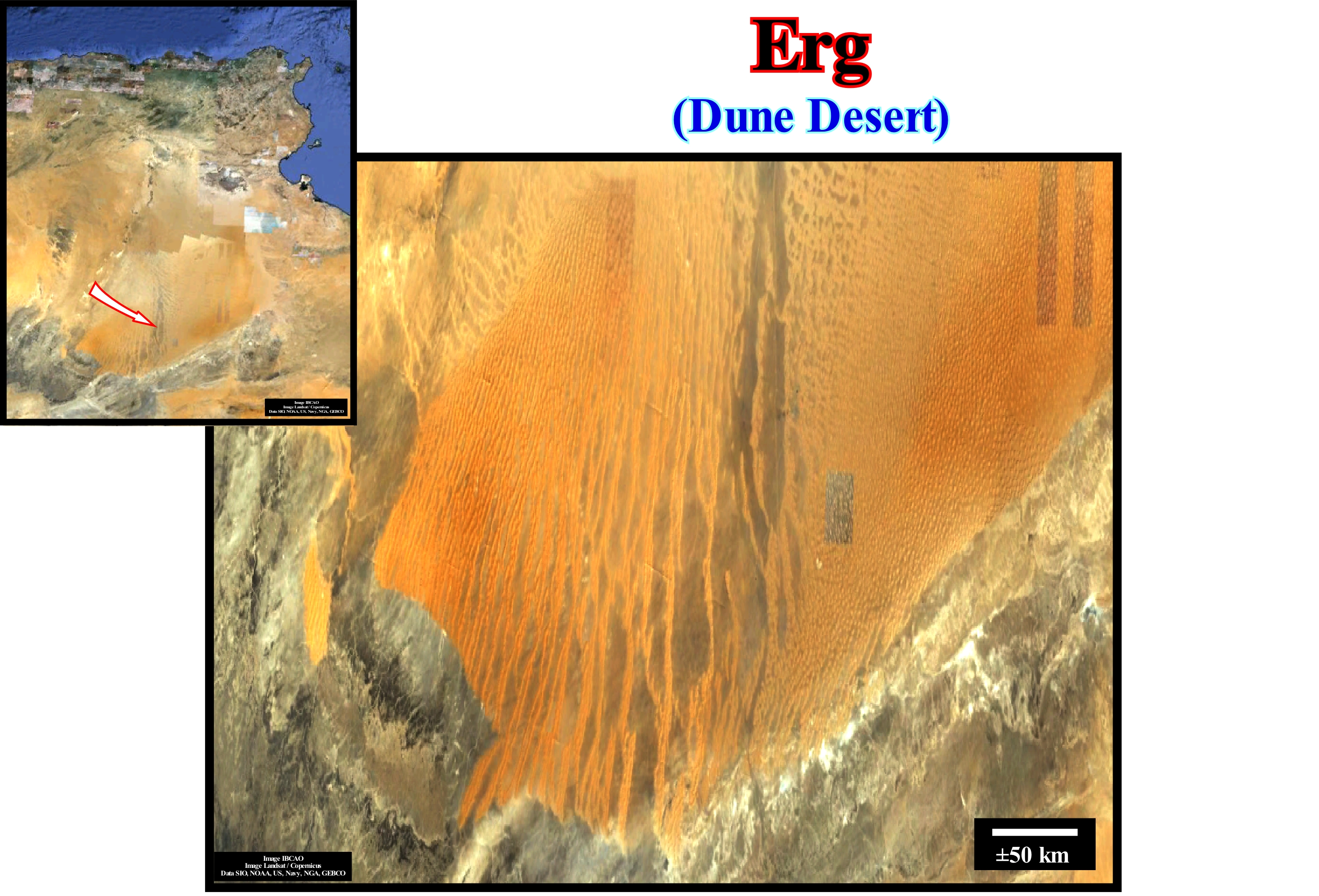
The Sahara Desert, which is located near the border of Algeria with Libya, with more or less 9 000 000 km2, contains several ergs as illustrated in this figure. The ergs are,, mainly concentrated in two belts limited between 20° and 40° north latitude and between 20° and 40° south latitude, which include regions that are crossed by very dry winds. Active ergs are limited to regions that receive on average less than 150 mm of rain per year. Sand seas or dune fields occur at the leeward of very dry regions of loose sand such as temporary dry rivers (which contain water only and during the rains), deltas, flood plains, outwash plains, dry lakes and beaches. Almost all important ergs are located at the temporary river leeward in areas that are too dry to withstand extensive vegetation cover and are therefore subject to long and continuous erosion. The sand from such areas migrates in the direction of the wind and builds large dunes whose movement is stopped or delayed by topographical barriers to the wind flow or convergence of the flows. The ergs and dune fields can migrate in the wind hundreds of kilometers from the source of the sand, which requires a great deal of time. The great majority of the geoscientists think that at least one million years was necessary to construct important dunes like those found in the Arabian Peninsula, North Africa and Central Asia. Important large and thick sand seas (ergs) can accumulate in subsident structural and topographic basins, such as Murzuk (Libyan SO) sand sea, which underlines, perfectly, the subsidence of the cratonic Murzuk basin (Paleozoic).
Erosion.......................................................................................................................................................................................................................................................Érosion
Erosão / Erosión / Erosion / 侵蚀 / Эрозия / Erosione /
The process by which small particles of rock and soil separate from their original location are carried by geological erosive agents (water, wind and ice), in response to gravity or living organisms (bioerosion).
See: « Relative Sea Level Fall »
&
« Davisian Cycle »
&
« Unconformity »
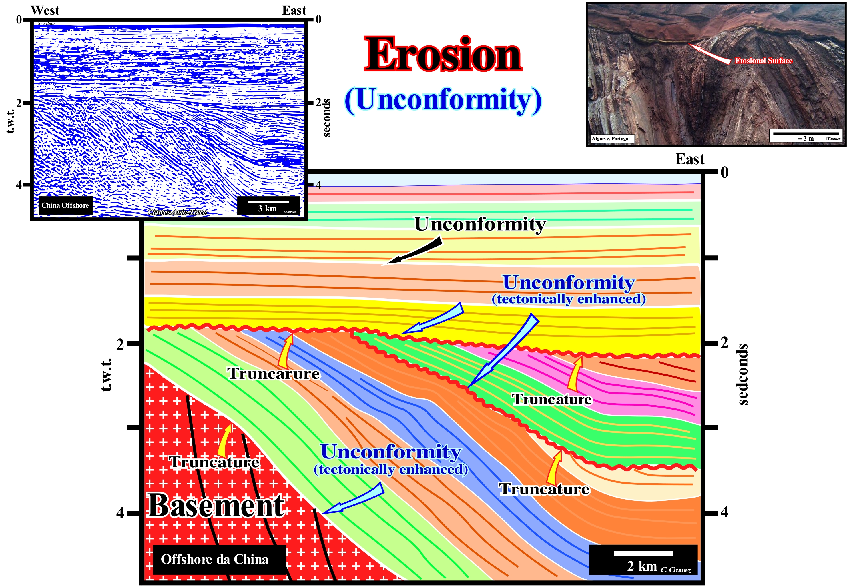
Erosion differs from weathering (chemical or physical transformation of minerals and rocks), although the two processes may be simultaneous. To have erosion, it is necessary to expose the rocks to erosive agents. Since a sedimentary interval is fossilized or covered by a more recent interval, the former, having been buried, is protected from erosion. To have erosion (total or partial) of a certain sedimentary interval is necessary, that it outcrops, either on the Earth's surface or on the sea floor, where it can be eroded by deep submarine currents. This means that, in general, there has to be a significant relative sea level fall, which not only raises the coastal plain but exhumes the sediments of the continental shelf as well (very significant decrease in available space for the sediments or accommodation). A significant fall of the relative sea level fall is the result of the combined action of the absolute (eustatic) sea level and tectonics. Relative sea level is local and referenced to the base of the sediments (top of the continental crust) or to the sea floor. The absolute or eustatic sea level is supposed to be global and referenced to the Earth's centre. Tectonics can sink or uplift the sea floor. In the first case the predominant tectonic regime is extensional, i.e., the sediments are lengthened. In the second, the dominant tectonic regime is compressional, i.e., the sediments are shortened. Certain geoscientists consider that an uplift corresponds to a negative subsidence. For them the subsidence may be positive (sedimentary lengthening created by a tectonic regime in extension) or negative (sedimentary shortening created by a tectonic regime in compression). Subsidence can act in the same or opposite direction of the absolute (eustatic) sea level changes. When subsidence is positive, the created available space for the sediments is added to the available space created by an absolute sea level rise. When subsidence is negative (uplift), the reduced space available for the sediments (accommodation) is diminished from the space created by a rise in eustatic sea level. Since there is a significant relative sea level fall, an erosional surface (unconformity) is created, which will be fossilized since the relative sea level begins to rise which, almost always, implies deposition. However, erosion is just evident in certain sections of the exhumed chronostratigraphic lines. In the onshore, erosion is, generally, done along the valleys where the water-courses running, particularly, in the incised valley. In the offshore, erosion is quite evident in submarine canyons and submarine valleys. The erosional surface, i.e., an unconformity can be more readily recognized by the strata terminations particularly when the incised valleys and submarine canyons are filled. That is why geoscientists, in the absence of tectonically enhanced unconformities (angular unconformities) on the seismic lines, try before all, to identify the fillings of incised valleys and submarine canyons to locate the unconformities. Then they follow them along the chronostratigraphic lines. On this tentative geological interpretation of a Canvas auto-trace of a detail of China offshore seismic line, it is evident that there are three major erosional surfaces. The lower unconformity, which is a tectonically enhanced, corresponds to the interface between the metamorphosed sedimentary series (Basement) and sediments with petroleum generating potential. The two other unconformities limit stratigraphic cycles, probably, continental encroachment subcycles. They were also enhanced by tectonics. Unconformities not enhanced by tectonics are difficult to identify. All the limits between the seismic intervals considered on this tentative interpretation (coloured intervals), which in most cases correspond, probably, to sequence-cycles, correspond to erosional surfaces (unconformities coloured in white) or their correlative deep-water paraconformities. On seismic lines, erosion is only evident in certain zones, such as near the basin edge (which are outside this auto-trace) or in the coastal plain, if the seismic line intersects the filling of an incised valley, some of which are visible in the western extension of this auto-trace.
Erosion Cycle.....................................................................................................................................................................................................Cycle d'érosion
Ciclo de erosão / Ciclo de erosión / Zyklus der Erosion / 侵蚀循环 / Эрозионный цикл / Ciclo di erosione /
Succession of phases of change of the relief (lanfdorms) tending to reduce the topography of the terrestrial areas, especially, the areas raised, recently. An erosion cycle that is, generally, composed of three phases: (i) Youth; (ii) Maturity and (iii) Old age, is hypothetical, since it develops in a way to horizontalize the surface of the land.
See: « Davisian Cycle »
&
« Erosion »
&
« Unconformity »
Geomorphological evolution of a continental area, raised by orogenesis, begins with a rapid and strong erosion of the elevated areas. Erosion is a combination of geological processes in which materials, which form the Earth's surface, are disaggregated, dissolved or worn away and transported from one place to another by natural agents. The main erosional agents are water, wind, ice, gravity and man, which characterize the different types of erosion. Erosion is a geological process as illustrated by photographs of the Bownot Meander (Utah, USA) between which there is a difference of 100 years. Water in its liquid form is responsible for (i) Pluvial erosion (ii) Fluvial Erosion ; (iii) Marine Erosion ; (iv) Wind Erosion ; (v) Glacial Erosion ; (vi) Gravitational Erosion and (vii) Anthropic Erosion. Pluvial erosion is caused by rainwater, which may be particularly important when soils do not have vegetation. Fluvial erosion is caused by river water, which transforms its courses into deeper valleys. Marine erosion is caused by the erosion of rocks and coastal soils, contributing to the formation of beaches, cliffs and e coastal landscapes. In wind erosion the wind is responsible for the weathering of rocks and transports the finest sediments away from erosion areas. In glacial erosion the ice induces erosion not only along the glacier coast, but also by the expansion, associated with freezing, that causes changes in the composition and arrangement of rocks. In gravitational erosion the gravity is, of course, responsible mainly for the erosion that occurs on the slopes and which consists of the rupture and transport of sediments under the action of gravity, with a gradual deposition of the fragments of rocks to the measure that slope and altitude decrease. In the anthropic erosion, the man is responsible, but generally does not have great influence, since this type of erosion is relatively recent and geologically short, but which is becoming more and more significant. All this means that water is, probably, the most important erosional agent. Under gravity, water wears the Earth's surface and transports the sedimentary particles until it has no more energy to do so. When water reaches sea level or the depositional base line of a lake or any other water-body, the river system loses energy and deposits what it transports. W. M. Davis described the erosion cycle using a channel (bed) of a river. A young river, as illustrated in this figure, has an important slope (slope) and a small width. It drains, quickly and more or less, in a straight line. However, over time (several centuries), the river erodes not only its channel (bed ), but also its banks, trying to reach the base level or sea level. A mature river, a stage at which the river tries to reach the base level, continues to erode the banks until, eventually, they disappear and form a plain. The old age state translates a stage in which the river flows along meanders, zigzagging on the coastal plain, trying to find the easiest way (principle of least effort) to reach the sea or another water-body. For many geoscientists, the equilibrium profile of a river is always provisional (when it has along its course a slope just sufficient to evacuate the charge and overcome internal frictions), since the river continues to deepen (there is erosion upstream, since materials are supplied to the current). For certain geoscientists, including P. Vail, a river reaches the base level on the bay-line, while for others, such as A. Miall, it is at the mouth of the river that it reaches the base level. Taking into account the tectonic evolution and the phases of the erosion cycle, the so-called "antecedent rivers" are those that precede the formation of the mountains they cross and maintain their original flow and direction. A river that follows the slope of a mountain is a "consequent river". A "non-consequent river" has no relation to the tectonics or stratigraphy of the lands it traverses. For D. Amsbury (1998), there is no place in the world, at least as far as he knows, where an erosion cycle can be corroborated, even in areas that have experienced neither glaciations, nor volcanism or tectonic shortenings, during the last millions years. The stages of maturity and old age are absent. Amsbury ends his criticism of Davies erosion cycle as follows: "I suspect that the Davis cycle and similar theories of the evolution of earthly relief have been advanced in a belief that the world has been oriented to near- for us Victorians, who evidently are in the acme of intellectual evolution. "
Erosional Hiatus.............................................................................................................................................................................Hiatus érosionnel
Hiato por erosão / Hiato por erosión / Erosion-Hiatus / 侵蚀间断 / Эрозионный перерыв / Iato erosivi /
Total interval of geological time, which, in a given place, is not represented by strata along a stratigraphic (chronostratigraphic) surface. If the hiatus comprises a geological time interval that can be, correctly, measured, the stratigraphic surface corresponds to an unconformity. A hiatus by erosion is always associated with, more or less, truncated strata. The hiatus corresponds to the geological time of the strata that were removed by erosion, not the time at which erosion occurred.
See: « Hiatus »
&
« Unconformity »
&
« Truncation »
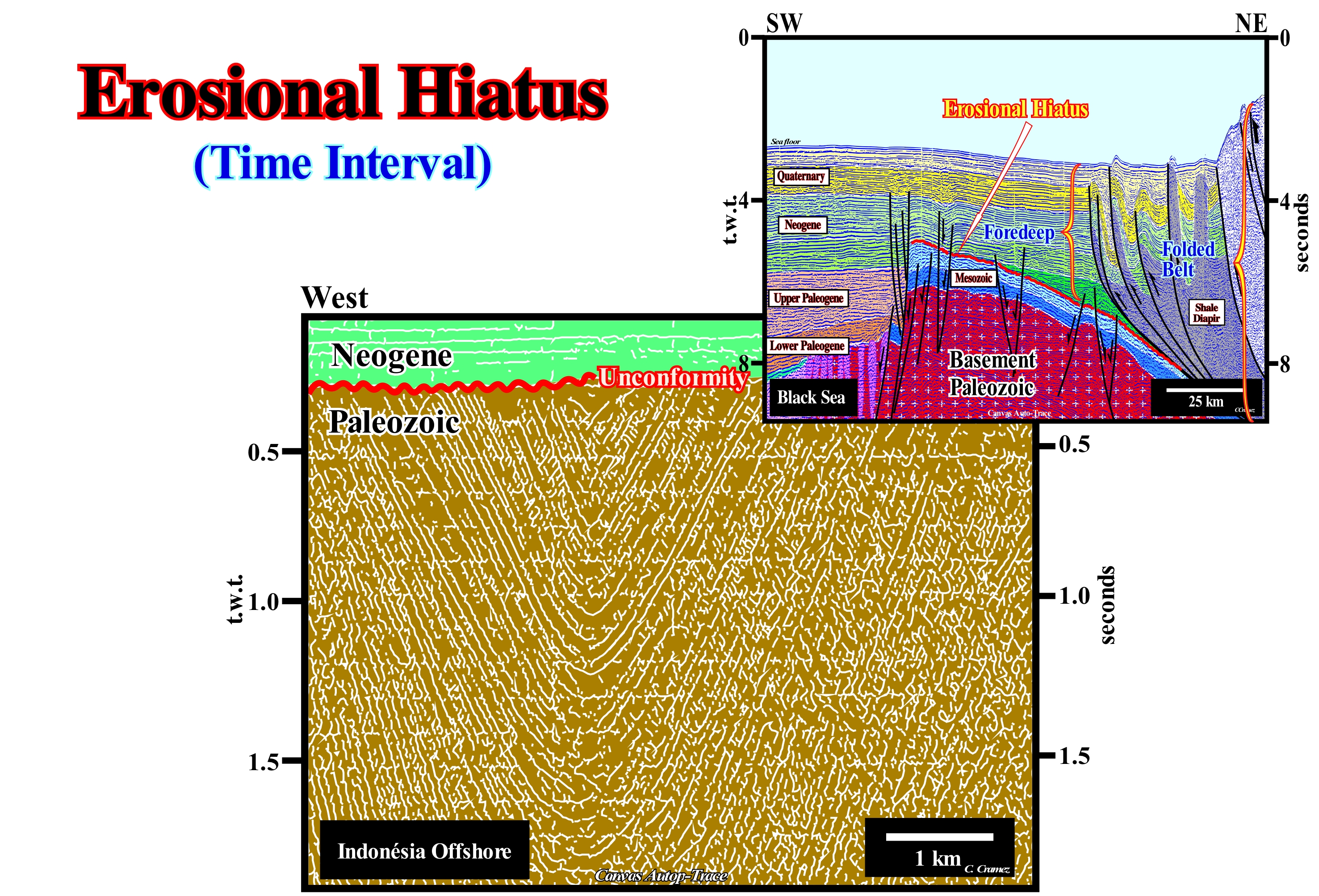
On this tentative geological interpretation of a Canvas auto-trace of a detail of an Indonesia offshore seismic line, the unconformity between the Paleozoic and Neogene sediments is evident. This unconformity, locally, tectonically enhanced (angular unconformity), created a quite large erosional hiatus. It separates sediments of very different ages. One can say that in the area in which this seismic line was shot, the hiatus is about 210 My, that is, the geological time of the strata, eventually, removed by erosion is about 210 My. However, it is likely that part of this hiatus corresponds to a hiatus due to no deposition. The same happens on the tentative interpretation of the Canvas auto-trace of a Black Sea seismic line, in which the main unconformity (in red) is tectonically enhanced. The loading of the thrusts of the folded belt seems to have been the primary responsible of basal unconformity of the foredeep. In this particular example, such unconformity is emphasized by the onlapping of the foredeep reflectors, which are, roughly, concordant with the unconformity. The presence of volcanic dikes, in the southern part of the auto-trace, suggests a highly intruded basement, which announces a possible oceanization of the basin. On these tentative interpretations it is necessary not forget that: (i) A unconformity (tectonically enhanced or not) underlines, always, an erosional surface (at least in Sequential Stratigraphy) ; (ii) An erosional surface is induced by a significant fall of the relative sea level, i.e., local sea level, referenced to the base of the sediments (top of the continental crust) or to the sea floor ; such a sea level fall puts the sea level lower than the basin edge, which can be continental edge when the geological conditions (when the basin has a shelf*) ; (iii) Significant relative sea level fall is induced by the combined action of eustasy and tectonics (subsidence of the sea level, during an extensional tectonic regime or uplift, generally, induced by a compressional tectonic regime) ; (iv) Eustasy (absolute or eustatic sea level, i.e., the sea level, supposed global, referenced to the Earth's centre) is, practically always, preponderant, at least with respect to the cyclicity of the stratigraphic column ; (v) Absolute (eustatic) sea level changes are, generally, faster than tectonic changers ; (vi) Within a tectonic cycle there are several eustatic cycles of different temporal orders (time wavelengths), that is, several eustatic and relative sea level falls, and so several unconformities ; (vii) Significant relative sea level falls create cryptic erosional surfaces ; (viii) Erosion is, mainly, associated with the destabilization of water-courses and just evident in privileged places (incised valleys, submarine canyons, continental slope, etc.) ; (ix) An unconformity is, always, a limit between two stratigraphic cycles ; (x) The erosional hiatus is given by the geological time-interval equivalent to the eroded strata ; (xi) The age of unconformity (age of the relative sea level fall) is given by the age of the turbidites associated with the fall of the relative sea level that created it, i.e., the age of the small no-depositional hiatus between the underlying and overlying sediments to the unconformity. The micropaleontologic results of an exploration well drilled in the area recognized by these seismic lines are not sufficient to date the unconformities (erosional surfaces coloured in red). All the micropaleontologic results of these wells can say is the ages are posterior to the Paleozoic and anterior to Neogene (for the Indonesia seismic line auto-trace) and posterior to the Mesozoic and anterior to the Neogene (for the Black Sea seismic line auto-trace). If a geoscientist says: "the age of the unconformity on the auto-trace of the Indonesian line is about 60 Ma (Danian)" he knows that in the same area an exploration well recognized, above the Paleozoic sediments, a turbidite sedimentary interval (submarine basin floor fans), and that the pelagic shales between the sand turbidite layers were dated about 60 Ma. In all other cases, the age of unconformity is a simple hypothesis based on an eventual correlation with the curve of coastal onlaps proposed by Jan Hardenbol et al. (1998).
(*) Within a sequence-cycle, during the second stage of development of the highstand prograding wedge (HPW), when the basin does not have a continental platform (shelf), the shoreline coincides with the continental edge, the basin edge remains the continental edge.
Erratic Block (Boulder)............................................................................................................................................................................Bloc erratique
Bloco Errático / Bloque errático / blockieren Sie erratische / 阻止不稳定 / Эрратический блок (останец тектонического покрова) / Masso erratico /
Rock or grain size superior to 256 mm in diameter. The city of Boulder, Colorado, was owed its name to the large number of blocks that were found there. Huge blocks are deposited during the melting of the glaciers, since the glaciers have, practically, an unlimited competence. As the blocks, which were transported by the glaciers, do not translate the lithology of the regions in which they are found, it is common to call them "erratic blocks".
See: « Granulometry »
&
« Glacier »
&
« Erosion »
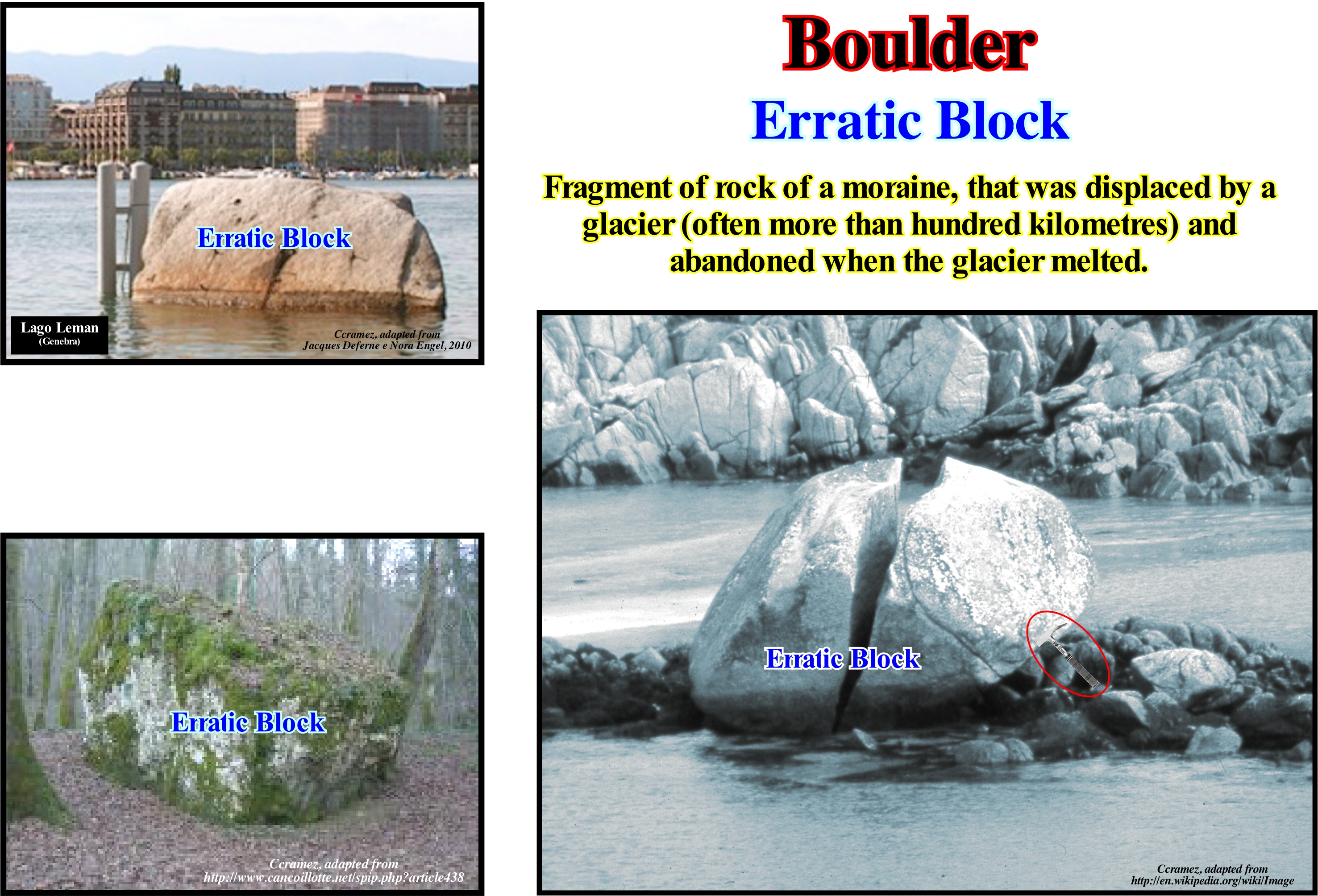
The photograph in the centre of this figure illustrates a large granitic block fractured on Ffionphor beach in northern Scotland. Of course, this block is not an erratic block, since, as can be seen in the photograph, its granite lithology corresponds to that of the rocks that appear on the coastline. Although certain blocks can be moved, manually, it is common to restrict, the term block, those whose dimensions are so large that a person can not move them. An erratic block, as illustrated in the upper right figure, designates a piece of rock that has fallen from the surface of a glacier or that has been torn from the ground by ice from a glacier and transported down the slope to the fluvio-glacial valleys. The erratic blocks corroborate the conjecture advanced by many geoscientists, the fluvio-glacial valleys, as in the foreland of the Alps, have been, in the past, covered by glaciers. In the region of Lucerne (Switzerland), for instance, the erratic blocks are very large (some weigh more than 5 tons), which leads one to think (it is the opinion of most Swiss geoscientists) that the thickness of the ice exceeded 1,000 meters. The idea of associating erratic blocks with glaciers was first invoked* by a Swiss minister Bernard Kuhn (1787), but it was not welcomed by the scientific community at the time that continued to associate the erratic blocks with the Noah's Flood. It was only much later, in July 1837, during the meeting of the Geological Society of Neuchâtel (Switzerland), that is to say, half a century later, that another Swiss Louis Agassiz (President of the Society), having adopted the ideas Jean de Charpentier, also of Swiss nationality, convinced the international scientific community that erratic blocks had been transported by glaciers, which was the first stage of his theory on glacial epochs.
(*) According to Jean de Charpentier (1786-1855), in the eighteenth century, many of the inhabitants of the Alpine valleys associated the striations of the rocks observed in the slopes of the valleys to a glacial erosion. Such a conjecture defended orally by Jean-Pierre Perraudin (1767-1858) in 1815 was, largely accepted, following the catastrophe that occurred in the valley of Bagnes in association with the Giétroz glacier. This glacier which was, already, known due to the rupture of an ice pack, which in May 1595 destroyed more than 500 houses and killed 140 people, created a natural dam following a landslide in the spring of 1818. The ice blocks obstructed the waters of the Dranse River, creating a lake about 60 meters deep and 3.5 kilometres long. Although in May 1818, the cantonal engineer Ignaz Venetz ordered the excavation of a trench that allowed the evacuation of nearly two-thirds of the volume of water retained by the lake. The summer heat weakened the ice dam, which caved under the pressure of water on June 16, 1818, destroying hundreds of dwellings in the valley and killing 44 people.
Escarpment.................................................................................................................................................................................................................Escarpement
Escarpamento / Escarpa / Bruchstufe / 崖 / Крутой спуск (уступ) / Scarpata /
Particular shape of the coastal slope, steep or with a large slope (15° to 90°), usually, carved out of coherent rocks by the action of marine agents (waves, currents), or by the joint action of marine, continental and biological morphogenic agents. Sea-water erosion on the coast that is cut to plumb.
See: « Cliff »
&
« Shoreface »
&
« Fair Weather Wave Base »
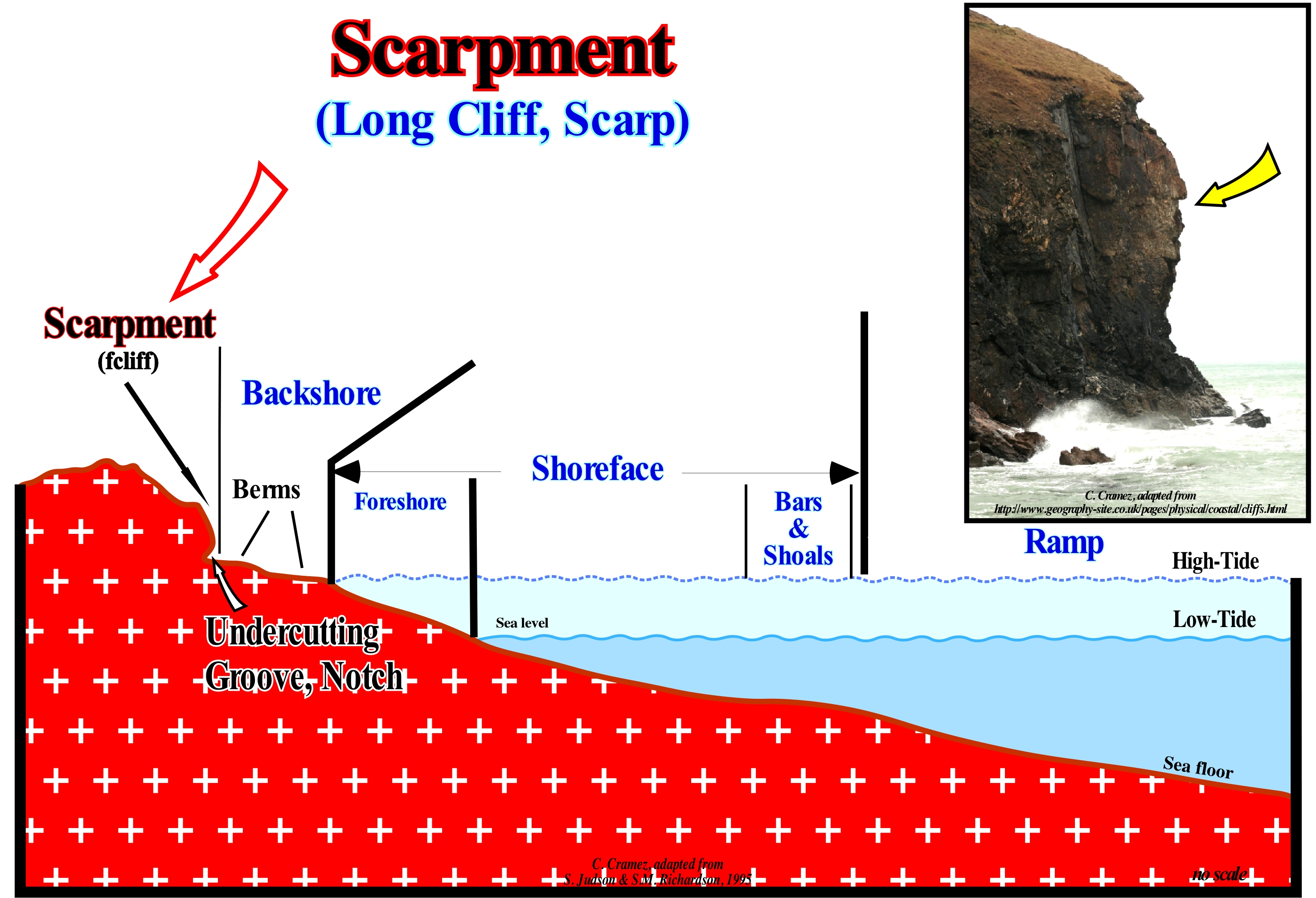
In the field, especially along the coast, different types of escarpments or cliffs can be identified (Moreira, 1984): (i) Plunging or Steep ; (ii) Fossil ; (iii) Dead or Abandoned; (iv) Active or Live and (v) Visor Cliff. At the base of the cliffs, the zone of attack of the waves is marked by the presence of undercuts in the form of grooves (notches) tending to deepen to the interior of the rocks in caves and tunnels. When the top of a cliff loses the support of its base it falls on the abrasion platform. The profile of a cliff (shape and slope) and of the abrasion platform depends on the lithological nature of the rocks (resistance to mechanical erosion and alteration), the geological architecture (horizontal, inclined concordant or discordant) and the intensity and frequency with the which marine erosion agents act. On seismic lines, cliffs are, easily, recognizable, especially when they are fossilized by transgressive sediments deposited during relative sea level rises in acceleration (created, in general, by a significant subsidence of the continent rather than a significant eustatic rise), which can move the shoreline continentward (kilometres). Such a displacement not only increases the length of the platform but also put the cliff under a water-depth higher than the erosive action of the waves. As the relative sea level stabilizes, the sedimentary particles transported from the continent, gradually, sink forming a regressive interval, which can fossilize the abrasion platform. This occurs when the terrigeneous influx is enough so that the new shoreline is located downstream of the cliff, without, however, exceeding the basin edge. A transgressive interval is a succession of smaller and smaller regressions, separated by transgressive surfaces. Most of the sedimentary particles come from the mainland and to have deposition it is necessary to have, always, a relative sea level rise *, which may be in acceleration or deceleration.
(*) Sea level, local, referenced at any point on the Earth's surface, which may be the sea floor or the base of the sediments, and which is the result of the combined action of absolute or eustatic sea level (global sea level, referenced to the Earth's centre) and tectonics (uplift when the predominant tectonic regime is in compressional or subsidence when it is extensional).
Esker ......................................................................................................................................................................................................................................................................Esker
Esker / Esker / Os (Landschaft) / 蛇形丘 / Эскер (оз) / Esker /
Long and narrow ridge of sand and gravel, more or less, stratified. It is deposited by a sub-glacial stream that moves between the walls or tunnels of a stagnating or thinning glacier and which is abandoned when the ice melts. An esker can branch out and be, more or less, discontinuous. Its direction is, usually, perpendicular to the front of the glacier and the length varies between 100 m and 500 km (discontinuities included), while the width varies between 3 and 200 m.
Ver: « Glacier »
&
« Drift Deposit »
&
« Depositional Environment »
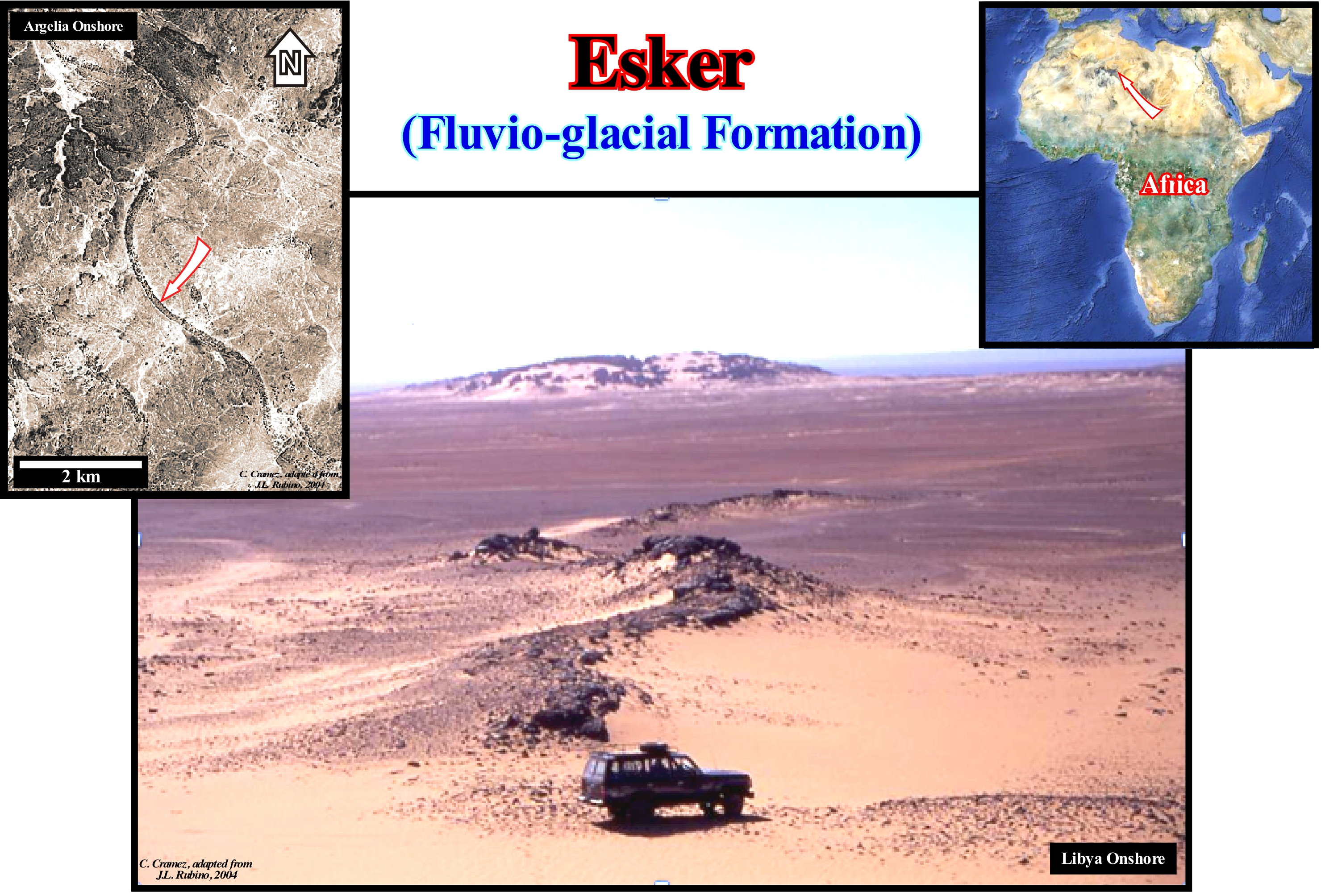
Most geoscientists think the eskers are formed in the tunnels of the glaciers by the currents that flow in and under them. Since the walls around a ice current melt, the deposits associated with the glacier remain, more or less, stable. Eskers can also form above glaciers, due to the accumulation of sediments in the supraglacial channels, crevasses (fissures) and in, more or less, linear zones between the standing blocks or in narrow coves on the margins of the glaciers. The eskers form near the end zones of the glaciers, where the ice does not move very quickly and is, relatively, thin. The rate of plastic flow and the melting of ice at the base of the glacier determines the size and shape of the subglacial tunnel which, in turn, determines the shape, composition and structure of an esker. Esker can exist as a single channel or can be part of a branching system with tributary eskers. The eskers, rarely, form continuous ridges. In general, they are interrupted by, more or less, important openings. The crests of the eskers are, generally, rounded with abrupt flanks. The length of an esker can range from 1 meter to several hundred kilometres. In this photograph (Tassili of Ajers in Algeria onshore), two eskers are, easily, recognized. In the field, the positive topographic anomaly that they produce, which can be greater than 50 meters, is a good criterion for their identification (in the old Paris/ Dakar rally, the competitors, who easily find the openings, places of passage, in the Sahara desert eskers, are the ones most likely to win). When buried, the eskers may be potential reservoirs-rocks and non-structural traps (morphological) in hydrocarbon exploration.

Send E-mails to carloscramez@gmail.com or to carlos.cramez@bluewin.ch with comments and suggestions to improve this glossary.
Copyright © 2009 CCramez, Switzerland
Last updated: July, 2019