
Tabular Reef............................................................................................................................................................................................Récife Plate-forme
Recife tabular / Récif placage / Arrecife tabular / Schelfriff / 资源(矿产) / Платформенный риф / Scogliera tabulare /
Coral reef* that develops in horizontal banks on the continental shelf or on submarine reliefs, usually, volcanic, that can emerge or be permanently submerged.
See: « Reef, Faro »
(*) A coral reef is an underwater ecosystem characterized by reef-building corals. Reefs are formed of colonies of coral polyps held together by calcium carbonate. Although many corals resemble plants, they are actually animals that belong to the class Anthozoa in the animal phylum Cnidaria, which includes sea anemones and jellyfish.
Tangential Oblique Configuration...................................................Configuration oblique-tangente
Configuração oblíqua-tangente / Configuración oblícua-tangente / Tangentiale schräge Konfiguration / 切线斜配置 / Наклонно-касательная конфигурация / Configurazione obliquo-tangente /
Stratal pattern, in which strata or associated seismic reflectors have a progradational geometry with dips decreasing baseward.
See: « Stratal Patterns »
&
« Reflection Configuration »
&
« Marine Regression »
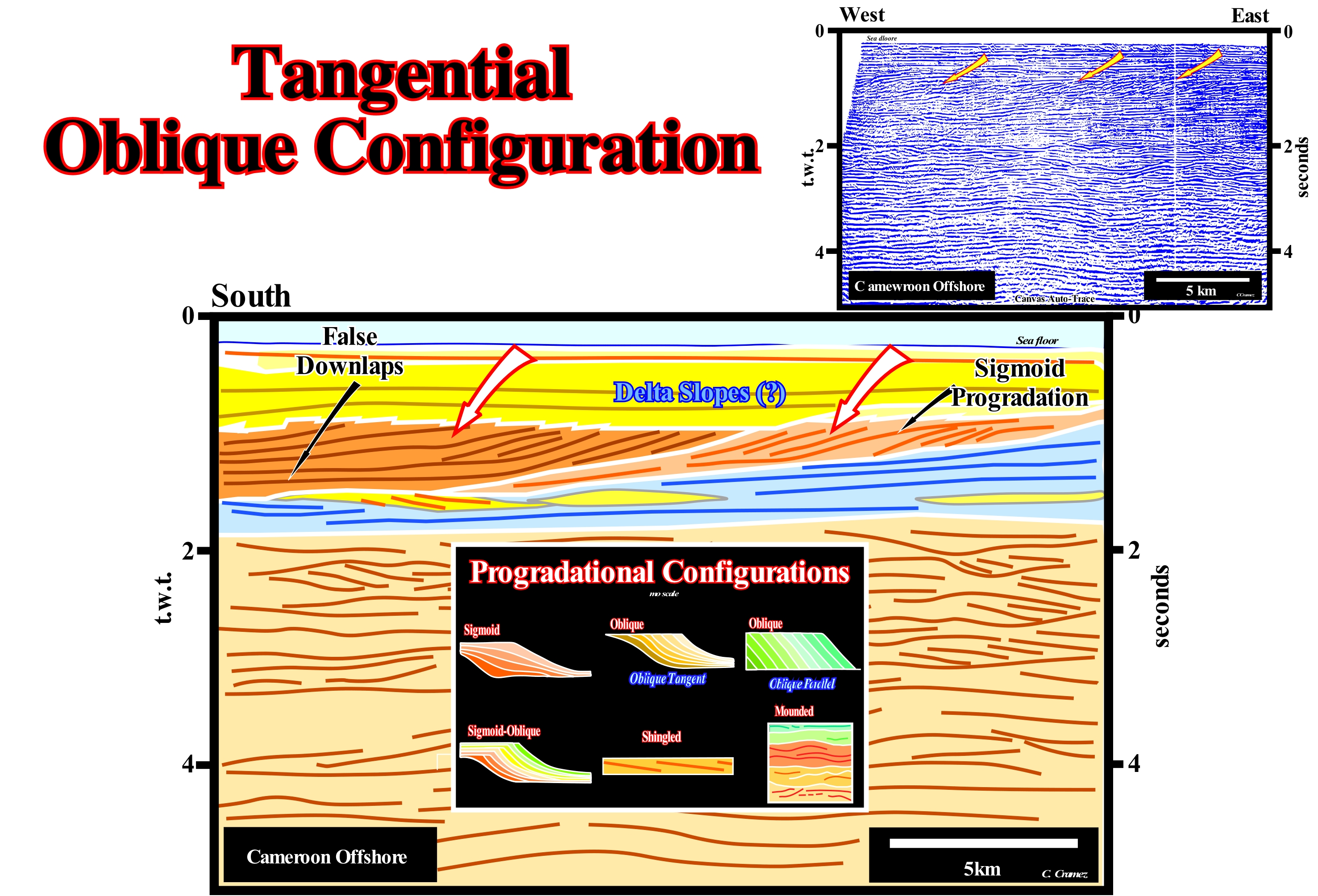
On this tentative geological interpretation of a Canvas auto-trace of a Cameroon offshore conventional seismic line (water-depth less than 200 meters), the upper intervals, underlined by the red arrows, exhibit in some parts an internal tangent oblique configuration (brown coloured intervals). This configuration is much better marked in the southern interval than in the northern interval. Within each of these intervals there are parallel oblique progradations, but at the eastern end of the northern interval, there are, even, several sigmoid progradations. The differentiation between all these types of progradations that, theoretically, define the internal configuration of a sedimentary interval can be done as follows: (i) In a sigmoid progradations, there are three segments (upper horizontal segment, seaward dipping segment and lower horizontal segment), since there is aggradation (vertical deposition or upbuilding) and progradation (lateral deposition or outbuilding) ; (ii) In a parallel oblique progradation, there is only the segment dipping seaward, since there is just lateral deposition, i.e., progradation (outbuilding) ; (iii) In a tangent oblique progradation, there are just the two lower segments, i.e., the segment dipping seaward (continental slope in this example) and the lower horizontal segment, since there is lateral deposition (progradation or outbuilding) and vertical (aggradation or upbuilding, sometimes emphasized by turbidite deposits on the base of the progradations). In terms of sequential stratigraphy, one can say sigmoid progradations are limited at the top by toplaps (or upper lapouts) and, at the base, by false downlaps, whereas an oblique parallel progradation is limited, at the top, by toplaps by nondeposition or by truncation, and at the base, by downlaps. A tangent oblique progradation is limited at the top by toplaps, which may be the result of a nondeposition or erosion and at the base by false progradations, in which the reflectors or strata at the base, are horizontal and continue seaward as independent stratigraphic units that are, often, so thin that they are not recognized on the seismic lines (when their thickness is lower than the seismic resolution, which varies, in general, between 20 and 40 meters). When the thickness between two false downlaps increases in the distal part (lower horizontal segment), turbidite deposits are likely. The thick seismic interval, under about 1.8 seconds double time (t.w.t.), which has on the upper part an internal mounded or wavy configuration, probably, corresponds to a stacking of sequence-cycles or incomplete continental encroachment subcycles formed, mainly, by submarine slope fans, which, geometrically, are characterized by sedimentary structures that the geoscientists of the oil companies call "gull wings". In this figure, the main internal progradation configurations of the seismic intervals are schematically illustrated: (i) Sigmoid, the progradations have a geometry of a S upside down, which means that the dip in the upper and lower parts is, relatively, low, while in the middle sector is much stronger ; (ii) Tangent Oblique, in this pattern, the seismic reflectors or associated strata have a decreasing slope toward the base ; (iii) Parallel Oblique, set of seismic reflectors with a parallel/oblique pattern, that is, a set in which the strata terminates downstream with a relatively important dip ; (iv) Sigmoid/Oblique, a particular case of the sigmoid configuration, in which the dip of the middle part of the progradations is very strong and the presence of toplaps by truncation is frequent ; (v) Shingled, the arrangement of the reflectors, or of the associated strata, is progradational, however, the progradations are oblique and almost lying down seeming that they take turns one after the other and (vi) Mounded or wavy, a series of more or less discontinuous seismic reflectors, often, with opposing slopes, interpreted as strata associated with turbidite deposits, generally, submarine slope fans with natural turbidite marginal dykes (turbidite levees) and the filling of the depression between (called turbidite channels, in case of obvious erosion), along which the currents transit.
Tar......................................................................................................................................................................................................................................................................Breu (poix)
Breu / Brea / Teer / 焦油 / Сланцевая нефть / Catrame /
Very viscous and black, acrid substance, more or less liquid, from the distillation of coal, oil or resin. Usually, synonym with Tar, Judean Bitumen and Asphalt.
See: « Asphalt »
&
« Seep »
&
« Shale Oil »
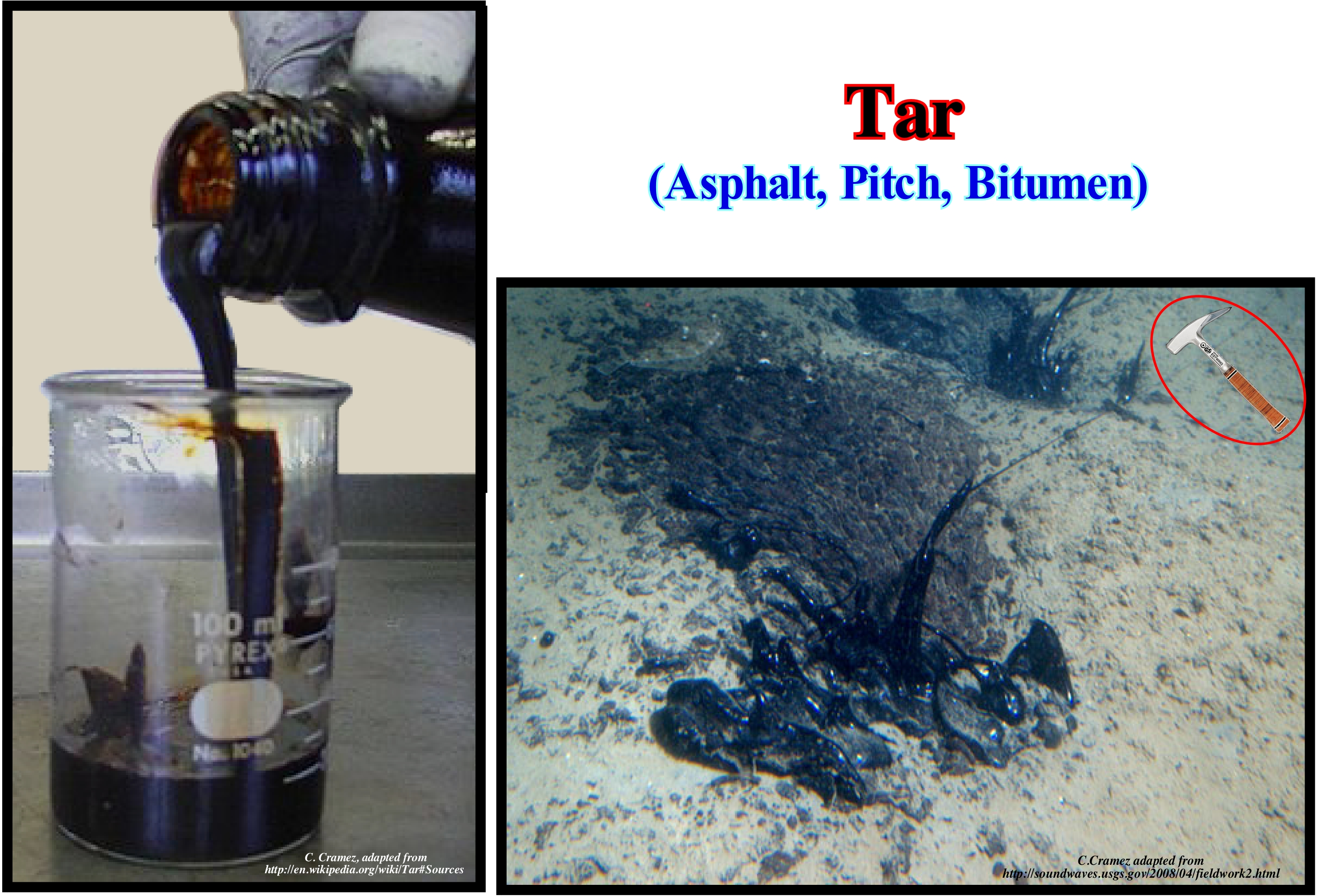
In several countries, the terms pitch, tar, bitumen, asphalt are, more or less, synonymous. However, sometimes they are used to describe very distinct substances. In English, the terms "tar" and "pitch" are synonyms, although the term "pitch" is used for a more solid material than "tar". In French but also sometimes in English the term "tar", which encompasses several terms, is used, mainly, for products derived from coal, while in Scandinavian countries it is used for derivatives the wood. All these products are toxic and carcinogens due to their high content of benzene, although in small concentrations they can be used in medicinal practices. These substances, when natural, i.e., when they appear in the field, are very precious indications for the geoscientists, who work in petroleum exploration. They suggest the presence, not very far, and in depth, of a generating petroleum sub-system, i.e., of mature source-rocks (when organic matter they contain has reached the oil window). Although many oilfields have been found alongside these oil exudations, such as in Venezuela and Trinidad, they can be interpreted in a, totally, different way, as the geoscientists of the old French company Elf said: oil exsudations can be (i) the vanguard of a battalion (oil field) hidden in depth or (ii) the rear of a battalion destroyed on the surface. Most of the geoscientists working in the oil companies consider that the exudations of Texas, Venezuela, Colombia, Indonesia, etc. can be interpreted with the vanguards of hidden battalions, while exudate in mountain ranges and tectonically inverted sedimentary basins, such as the Lusitanian geographic basin in Portugal, are best interpreted as the rearguard of destroyed battalions. The case of the Lusitanian geographic basin is, in particularly, typical. The great majority of petroleum exudation in Portugal was evidenced in the late nineteenth century by the french geoscientist Paul Choffat, who interpreted them as remains of oil fields (rearguard of destroyed battalions), conjecture corroborated, until today, by the results all exploration wells drilled in the top of structural traps (four way dip closure).
Tar (Bitumen of Judea)...........................................................................................................................................................................Poix de Judée (Asphalte)
Betume de Judéia (asfalto) / Pez de Judea (asfalto) / Judäischen Steigung (Asphalt) / 犹太间距(沥青 ) / Природный битум / Pece de Judea (asfalto) /
Synonym with Asphalt, Mineral Pitch, Tar, i.e., a substance very viscous, and coming from the distillation of coal, resins or oils. The term bitumen of Judea, probably, comes from the fact that this bitumen was found near Babylon in Judea, in a lake called asphalt. The bitumen of Judea is also known as gilsonite..
See: « Petroleum »
&
« Seep »
&
« Asphalt »
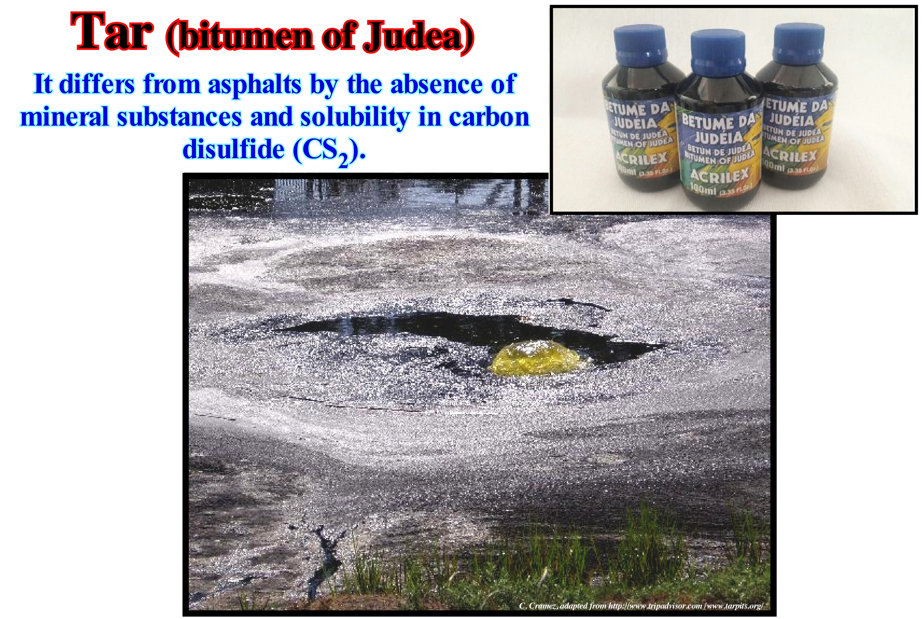
Bitumen of Judea is a mineral impregnated with bitumen. It is a natural asphalt type, i.e., not derived from petroleum that is soluble in hydrocarbons, among which the most common is turpentine*. The term bitumen of Judea* * (asphalt) is, certainly, a translation of "pitch", which is the name that the British give a series of viscous liquids that look solid. Thus, for them the pitch can be made from petroleum products or from plants. The former, as illustrated in this figure, are primarily known as bitumen and second as resins. In French, the terms "goudron, poix minérale, pitch, pitch and asphalte" are, practically, synonymous. In some dictionaries the term pitch corresponds to the black substance and highly viscous derived from charcoal (pitcher a table means to cover it with tar or pitch the surface of the table), but according to the same dictionaries, the term "pitch" is synonymous with (i) Tar, which is a viscous, dark substance, penetrating odour, more or less, liquid obtained by distillation of organic matter, such as coal, wood, oil, etc. ; (ii) Rosin*** ("Breu"), which is a very very dark solid, which is obtained by distillation of tar, oils or resins, and (iii) Bitumen, which is a mineral substance of variable consistency, rich in carbon and hydrogen, which is in nature, which burns with a flame of thickness and which comes from the decomposition of organic matter. Anglo-Saxon geoscientists cover all these terms in a single "Tar". Tar corresponds to a black, viscous resin, produced from wood and pine roots by destructive distillation of pyrolysis. Products similar to bitumen ("tar") can be produced from other forms of organic matter, such as, for example, peat or mineral products, such as hydrocarbons, including fossil oil. Thus, the term "tar" appears to be misused when it refers to La Brea asphalt near Los Angeles ("tar" natural wells) or to sand and bitumen or heavy oil mixtures ("Tar Sands" of the Orinoco) or of Burma oil ("Tar" of Rangoon). In English, "tar" and "pitch" are used interchangeably, although "pitch" is considered more solid and "tar" more liquid.
(*) Essence of turpentine or a mixture of aliphatic hydrocarbons, with a distillation range of 151 to 240° C, used, mainly, as a solvent, but also in the manufacture of waxes and inks.
(**) Today, bitumen of Judea is used by carpenters and restorers to give it an aged appearance. It creates shadows in grooves, frames and other cavities. It also serves as a tincture for oils or waxes (oak appearance when mixed with en-caustic, that is, with purple paint mixed with wax). It is in thick liquid form or powder (dissolved in turpentine, for example).
(***) Rosin is the solid residue obtained after distillation of turpentine, oleoresin, substance harvested from coniferous trees and in particular pine trees by an operation known as tapping.
Tar (Heavy viscid pitch)...................................................................................................................................................................Tar (Breu, poix de Judée, goudron)
Alcatrão, Breu, Pez, Piche / Alquitrán, Brea / Tar (Teer) / 的tar (焦油) / Гудрон (дёготь) / Tar (catrame) /
Synonym with Asphalt, Mineral Pitch, that is to say, a very viscous substance and dark coming from the distillation of the coal, the resins or the oils.
See: « Petroleum »
&
« Seep »
&
« Asphalt »
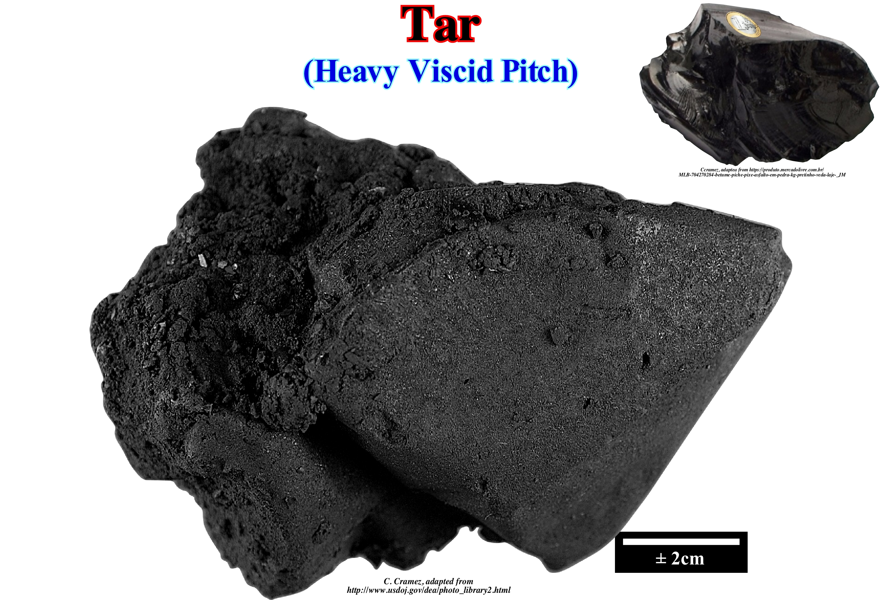
This figure illustrates a sample of what many geoscientists sometimes call pitch. However, in the Dictionary of the Contemporary Portuguese Language of the Academy of Sciences of Lisbon, the term pitch corresponds primarily to the resinous secretion of pine and other coniferous trees, but may also be synonymous with: (i) Asphalt, which is a viscous, dark, penetrating, more or less liquid substance obtained by the distillation of organic materials, such as coal, wood, oil, etc. ; (ii) Rosin ("breu"), which is a very dark or black solid substance obtained by distillation of tars, coal, resins or oils, and (iii) Pitch, which is a very viscous black substance from coal (a table, it means to apply tar or fish on the surface of the table). All these terms, pitch, pitch, asphalt and pitch are often synonyms of "Tar", which in Wikipedia is defined as: a black and viscous resin, which is produced from wood and pine roots by distillation destructive effect on pyrolysis. Products similar to "tar" can also be produced from other forms of organic matter, such as peat. Minerals that look like tar can be produced from fossil fuels including petroleum. The term "Tar" is used to express different substances, such as: (i) Natural tar wells to designate the asphalt accumulations of La Brea in Los Angeles ; (ii) "Tar" sand deposits to designate mixtures of sand with bitumen or heavy oil, or (iii) "Tar" from Rangoon to designate oil or naphtha from Burma, which in reality is simply oil. The term "tar" is as vague as the terms tar, pitch and pitch in other languages. The terms "tar" and "pitch" are, often, used interchangeably, although the pitch is considered more solid, while the "Tar" is more liquid. In other languages, as in Portuguese seems the opposite, since one can paint a table with tar and not with pitch. Avoid using all of these terms, but if you use them, it is best to define them first.
Tar (Pitch, asphalt)...............................................................................................................................................................................Tar (Breu, poix de Judée, goudron)
Alcatrão, Breu, Pez, Piche / Alquitrán, Brea / Tar (Teer) / 的tar (焦油) / Гудрон (дёготь) / Tar (catrame) /
A very viscous and dark, slightly more or less liquid substance from the distillation of coal, oil or resin. Usually synonymous with Asphalt, Mineral Pitch.
See: « Hydrocarbon »
&
« Petroleum »
&
« Shale Oil »
Tar is often mistaken for petroleum bitumen. This confusion is due to the invention of macadam, which in the past was used to coat the roads and was made from tar. At present, tar is no longer used to improve pavement resistance to hydrocarbons, since petroleum bitumen is soluble in hydrocarbons. The terms tar, pitch and asphalt, though, sometimes, regarded as synonymous, are in some countries used to describe very different things. The term "tar" encompasses several foreign terms, whose definitions are more literary than scientific. All these terms are products, directly or indirectly associated, with sedimentary rocks rich in organic matter, that is, source-rocks or petroleum generating source-rocks*, which may be marine or nonmarine. Nonmarine source-rocks (lacustrine and deltaic) are deposited, mainly, in the rift-type sedimentary basins and at the base of the divergent continental margins. The organic matter of lacustrine source-rocks is type I **, while that of deltaic rocks is mainly type III, with a special reference to coal. Organic rocks rich in organic matter (type II) are, preferably, deposited in the transgressive sediments (TI) of the sequence-cycles, which are induced by 3rd order eustatic cycles (characterized by having a time-duration between 0.5 and 3-5 My). The mechanism of formation of this type of organic matter within a sequence-cycle is well known to geoscientists: (i) The first transgressive surface of the sequence-cycle differentiates the depositional coastal break of deposition surface (more or less the shoreline) from the continental edge and moves continentward creating a small continental shelf ; (ii) During the transgressive interval (TI), successive relative sea level rises (marine ingressions) accentuate the continentward displacement of the depositional coastal break of the depositional surface, increasing the extension of the platform, creating, in the distal part, geological conditions with a low sedimentation rate, which favour the formation (abundant fauna) and preservation (low oxygen content) of the organic matter, especially, when a cool and nutrient rich marine current is present in the region.
(*) In geology and particularly in petroleum geology, a source-rock is a sedimentary rock rich in organic matter capable of generating hydrocarbons (oil or gas) function of the temperature reached by burial. When rock, throughout its geological history, locally, was not buried, sufficiently, to generate hydrocarbons, it is, in that area, considered as a potential source-rock.
(**) In petroleum geology, three main types of organic matter (kerogen) are considered: A) Type I or Sapropel ; B) Type II or Planktonic ; C) Type III or Humic. Type I organic matter can be characterized as follows: (i) It consists, basically, of proteins and lipids ; (ii) Contains alginate, amorphous organic matter, cyanobacteria, freshwater algae and resins of terrestrial plants ; (iii) Hydrogen/Carbon Ratio > 1.25 ; (iv) Oxygen/ Carbon Ratio <0.15 ; (v) Tendency to generate oil ; (vi) It mainly derives from lake algae and is formed mainly in anoxic lakes ; (vii) It has few cyclic or aromatic structures. Type II organic matter that can be (a) Evaporitic when formed, mainly by spores and pollens ; (b) Cutinitic when formed, mainly, by terrestrial plants rich in cutin ; (c) Resinite, when formed mainly by terrestrial plants rich in resin and resins resulting from the decomposition of animals ; (d) Liptinitic, when formed, basically, by the lipids of terrestrial plants. Type II organic matter can be characterized by: (i) Tendency to generate oil and gas ; (ii) Hydrogen / Carbon Ratio <1.25 ; (iii) Oxygen / Carbon Ratio between 0.03 and 0.18. The characteristics of Type III organic matter are: (i) Rich in coastal terrestrial plants (absence of lipids and waxy matter); (ii) Hydrogen / Carbon Rate <1; (iii) Oxygen / Carbon Ratio between 0.03 and 0.3; (iv) Tendency to produce coal and gas. ((https://en.wikipedia.org/ wiki / Kerogen).
Tar Mineral...............................................................................................................................................................Poix minérale (Pissalphalte, goudron)
Pez (alcatrão, ozocerite) / Pez Mineral (pissasphalte, alquitrán) / Erdpech (pissasphalte, Teer) / 的矿物间距(pissasphalte,焦油) / Природный битум (смолы) / Mineral pitch (pissasphalte, tar) /
Very viscous and dark substance from the distillation of coal, resins, oils or natural (ozokerite). Often synonym with Tar, Judean Bitumen, Asphalt.
See : « Petroleum »
&
« Seep »
&
« Asphalt »
Although the term "pitch" is used by English geoscientists interchangeably with the term "tar", "pitch" is considered more solid than "Tar". The term mineral tar or pitch is used to designate a pitch resulting from a mineral product. The English people, not necessarily the geoscientists, use the term tar to designate a whole range of viscous liquids that look solid and can be produced either from plants or from mineral products as from fossil hydrocarbons. The term "tar" is defined (Wikipedia) as a black and viscous resin produced from wood and pine roots by destructive distillation on pyrolysis. A mineral tar is a tar which has been produced from a fossil hydrocarbon, as is the case illustrated in this figure (Trinity). In Portugal, for instance, the terms tar, pitch, asphalt and bitumen are almost always considered as synonyms. In the Dictionary of the Contemporary Portuguese Language of the Academy of Sciences of Lisbon, the term tar corresponds to a very viscous black substance originating from coal (to spray a table, i.e. to apply pitch or pitch on the surface of the table), which is in contradiction with the definition of the English, who consider that pitch is more solid than bitumen. However, the same dictionary considers that mineral tar or resin (tar resulting from plants or organic tar) is synonymous with: (i) Tar, which is a viscous, dark, penetrating, more or less liquid substance obtained by distillation of organic materials such as coal, wood, oil; (ii) Rosin (*Breu"), which is a very dark or black solid substance obtained by distillation of tars, coal, resins or oils, and (iii) Bitumen, which is a mineral substance of varying consistency, rich in carbon and hydrogen, which is found in nature, which burns with a thick flame and which comes from the decomposition of organic matter. The best way, perhaps, to use the term pitch or tar would be to use mineral tar when the origin mineral and tar (organic tar) when the origin is vegetable. Either way always avoid using these terms. However, if you are required to use them, set them first.
Tar Sand (Oil sand)...........................................................................................................................Sable asfaltique, Sable betumineux
Areia asfáltica / Arena asfáltica / Teersand / 焦油砂 / Нефтяной песок / Tar sabbia /
Sand containing a sufficient amount of asphalt for a possible commercialization. In general, a tar sand is a bituminous (petroleum) sand, which has lost the light components. Expression considered, often, as synonymous with "Sand Oil" or "Bituminous Sand".
See: « Bituminous Sand »
&
« Petroliferous Sand »
&
« Asphalt »
Tar sands or oil sands (according to certain geoscientists) are a combination of sand, clay, water and bitumen (heavy black and viscous heavy oil). The tar sand can be extracted in the open air and processed to extract bitumen, which is then converted into light oil. Bitumen from tar sand can not be extracted from the ground in its natural state by pumping as is, usually, for oil. However, it can be extracted: (i) Open air ; (ii) By wells; (iii) By heating with water vapour and (iv) Other recovery processes. Recovery processes are, generally, composed of two phases. An extraction phase and a separation phase, whose purpose is the individualization of the bitumen, clay, sand and water that make up the oil sand. Bitumen needs additional treatment before it is refined. As bitumen is very viscous, dilution with lighter hydrocarbons is, almost always, necessary for it to be transported by pipelines. In southern Venezuela, the Orinoco oil belt is largely composed of asphaltic or tar sands, since along the long lateral migration, from north to south, the petroleum has lost its light elements and has become very heavy oil that flows very difficult. These sands do not appear. They are buried at relatively small depths (between 300 and 1,200 m) and its is the oil (heavy, about 8-10° API *) that keeps the sand grains in suspension. Oil is mobilized by steam injection, but the profitability of extraction depends, mainly, if the extraction is or not accompanied by a compensatory subsidence. As the quartz grains are suspended in the heavy oil (they do not touch), as the oil is extracted, in a favourable case, the sand compacts itself which causes a subsidence of the overlying stratigraphic levels favouring the production of the heated oil . It is this subsidence that is responsible for the depressions (between 4-10 m) observed, often, in the current topography.
(*) The API grade is an arbitrary scale (the higher the oil density, the lower its API grade) that measures the density of petroleum liquids, which was created by the America Petroleum Institute along with the National Bureau of Standards and which uses it to measure the relative density of liquids. ° API = ⎨141.5 ÷ δ (density of the sample relative to water)⎬ - 131.5.
Taxa (Biology)...............................................................................................................................................................................................................................Taxa (Biologie)
Taxa (biologia) / Tasa (biología) / Taxe (Biologie) / 类群(生物) / Таксоны (биология) / Taxa (biologia) /
Groups of one or more organisms, which taxonomists (scientists who practice and study scientific classifications) consider units. Taxa is the plural of táxon, which is, usually, defined by a name and a rank, although none of these is an obligation.
See: « Theory of Evolution »
&
« Principle of Fossil Succession »
&
« Linnaean System »
A taxon (plural is taxa) is a group of (one or more) organisms that a taxonomist considers to be a unit. Normally, a taxon is given a name and a classification, although it is not a necessary and indispensable thing. Defining what belongs or what does not belong to this taxonomic group is the work of a taxonomist (specialist in taxonomy, that is, in the classification of living beings). It is not uncommon for taxonomists to be in total disagreement as to exactly what exactly a taxon belongs to, or the exact criteria should be used to define it. Taxonomists, sometimes, make a distinction between "good" taxa (or natural) and others that are not "good" taxa (or artificial). Nowadays, it is common to define good taxa as those that reflect probable evolutionary relationships (phylogenetic). But this, too, is not mandatory. A taxon can have a formal name or a scientific name. The scientific name is governed by a nomenclature code, which defines the rules for determining which scientific name is correct for a particular group. In biological nomenclature, the hierarchical levels of the scientific classification of living beings, which from the kingdom to the species, are called the "hierarchical levels", form the different floors of the building that encompasses the systematic rate of a certain group of animals, plants, fungi, protists, bacteria and archaebacteria. Classification provides a classical hierarchy encoded in seven main levels and five secondary levels, presented in descending order: (i) Kingdom ; (ii) Branch, Division or Phylum ; (iii) Class ; (iv) Order ; (v) Family; (vi) Tribe ; (vii) Gender ; (viii) Section ; (ix) Series ; (x) Species; (xi) Variety ; (xii) Form. The seven main levels are Kingdom, Phylum, Class, Order, Family, Gender, and Species, i.e., in mnemonic form, KiPhClOrFaGenSp. Additional levels (or interleaved levels) are always possible by adding the "sub", "infra" or "super" prefixes to the major or minor taxonomic levels to sort higher or lower (superordinate, subgenus, infraclass, etc.).
Taxon (Biology)...................................................................................................................................................................................................................Táxon (Biologie)
Taxon (biologia) / Taxón (biología) / Taxon (Biologie) / 类群(生物) / Таксон (таксономическая единица) / Taxon (biologia) /
Group of one or more organisms considered by the taxonomists as a unit. A taxon corresponds to a taxonomic unit, i.e., to a population or group of populations of organisms which are, generally, phylogenetically related and which have characteristics in common that differentiate them from other units (of another geographic population, gender, family, order). A taxon encompasses all taxa (plural of taxon) of lower taxonomic level and individual organisms.
See: « Taxa (biology) »
&
« Animalia (kingdom) »
&
« Linnaean System »
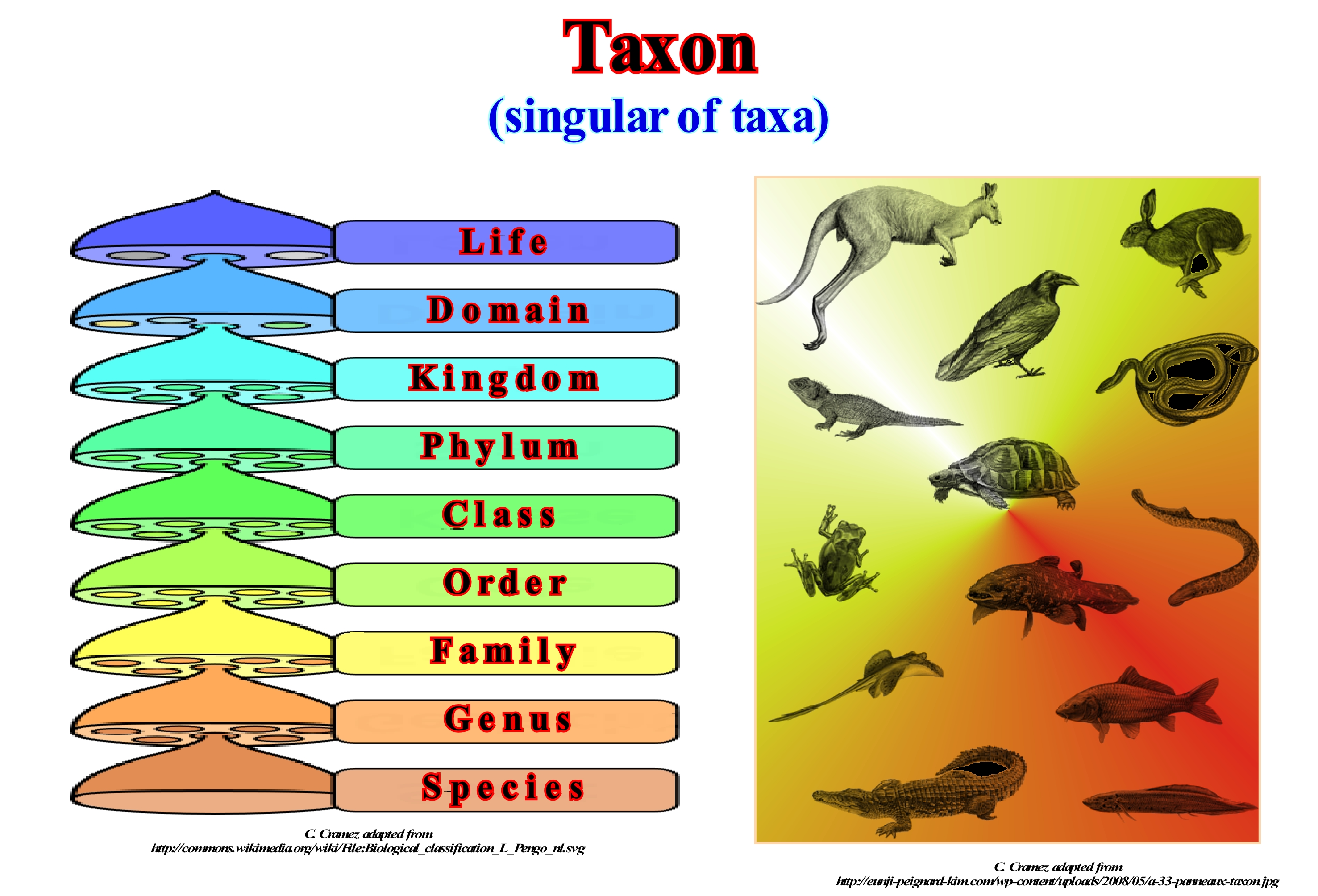
The glossary of the International Code of Zoological Nomenclature (1999) defines a taxon (do not forget that the plural of taxon is taxa), as a taxonomic unit, denominated or not, a population, or group of populations of organisms that (a geographic population, a genus, a family, an order) from other similar units. A taxon includes all lower-level taxa and organisms As shown in this scheme, biological nomenclature, there are different taxonomic levels (rank), which emphasize the hierarchical levels of scientific classification of living beings. Each of these taxonomic levels ranging from the kingdom to the species, form the different floors of the building that encompasses the systematic rate of a particular group of animals, plants, fungi, protists, bacteria and archaean. The classification provides a classical hierarchy encoded into seven main levels and five secondary levels. In descending order for the living world the different levels are: (i) Kingdom; (ii) Branch, Division or Phylum; (iii) Class; (iv) Order; (v) Family; (vi) Tribe; (vii) Gender; (viii) Section; (ix) Series; (x) Species; (xi) Variety; (xii) Form. The seven main levels are Kingdom, Phylum, Class, Order, Family, Gender, and Species, i.e., in mnemonic form, ReFClOrFaGenEs. Additional levels (or interleaved levels) are always possible by adding the "sub", "infra" or "super" prefixes to the major or minor taxonomic levels to sort higher or lower (superordinate, subgenus, infraclass, etc.).
Tectonic Basin......................................................................................................................................................................................Bassin tectonique
Bacia tectónica / Cuenca tectónica / Tektonischen Becken / 构造盆地 / Тектонический бассейн / Bacino tettonico /
Basin containing a certain amount of sedimentary or volcanic strata that were deposited due to crustal movements that preceded or accompanied the strata deposition.
See: « Basin (sedimentary) »
&
« Structural Basin »
&
« A-Type Subduction (Ampferer) »
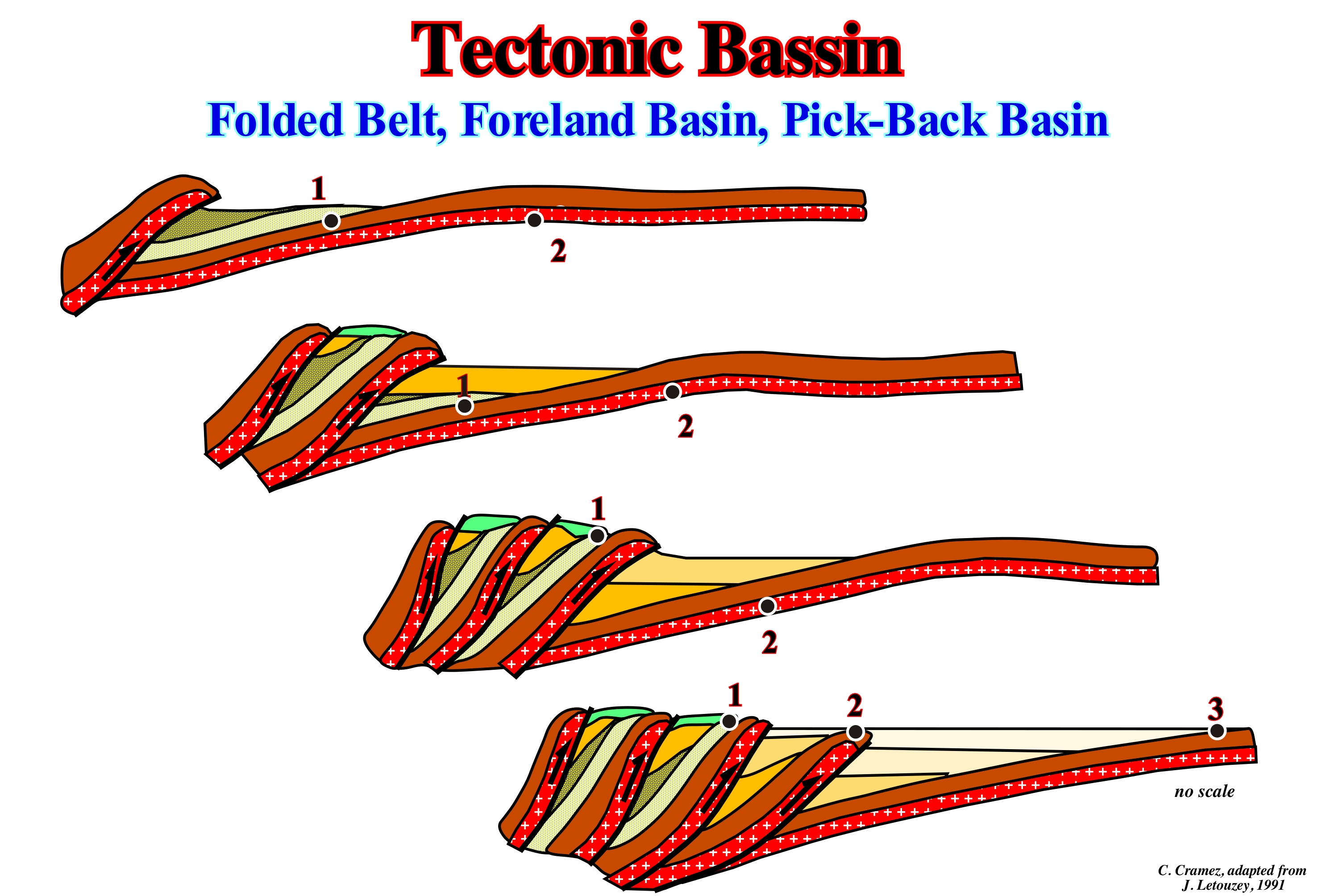
As illustrated in this sketch, a foredeep or foreland basin can be considered as a tectonic basin, since the subsidence is flexural, i.e., induced by the overload created by the thrusts. In fact, on a platform*, a thrust creates a subsidence, which, combined with the eustasy, produces an increase in the space available for the sediments (accommodation) allowing the deposition of a first sedimentary interval on the platform. Onlapping underline the unconformity between the platform and the basal interval of the foredeep, in which the terrigeneous influx comes, mainly, from the craton. At the same time that the weight of the thrust produces the subsidence of the platform, it also creates a peripheral bulge in the craton, that is, a point where subsidence is not only null, but which, by reaction to it, rises slightly. The continuation of the sedimentary shortening, induced by a compressive tectonic regime (σ1 horizontal) produces a new thrust (in this example, the shortening is in sequence, since the most recent thrust is the one closest to the craton), which increases the overload. Thus, the accommodation increases and a new peripheral bulge forms upstream of the previous one (towards the craton), which allows the deposit of another sedimentary interval, which deposits over the anterior and over the platform. The proximal onlaps of this new interval, which is concordant with the previous one, fossilize the old peripheral bulge, thus accentuating the unconformity of the base of the foredeep base. As the frontal thrust migrates toward the craton, the foredeep basal sediments and the peripheral bulges are incorporated into the thrusts. On the other hand, as the mountain belt rises, due to shortening, it will produce a more important sedimentary charge, which at a certain moment is more important than the terrigeneous influx coming from the craton. It is in this type of basin that it is probable that subsidence, i.e., tectonics and not eustasy, is the parameter responsible for the cyclicity of sedimentary deposits and the formation of unconformities.
(*) The term platform here refers to a substrate rather than a continental shelf.
Tectonic Groove (Crescent tectonic gouge)........................................................................................................Lunule tectonique
Lúnula tectónica / Lúnula tectónica / Lunula (groove) tektonischen / Lunula构造 / Тектоническая борозда / Lunula tettonica /
Pullout structure (sliding traces) with crescent shape visible, often, on the bedding planes of the flanks of anticlines resulting from the sliding of the layers on layers during sedimentary shortening. Tectonic origin shallow fissure in a rock face or between two rock faces, forming an angle of more than 120° (https://www.collinsdictionary.com/dictionary/english/groove).
See: « Tectonics »
&
« Anticline »
&
« Sedimentary Shortening »
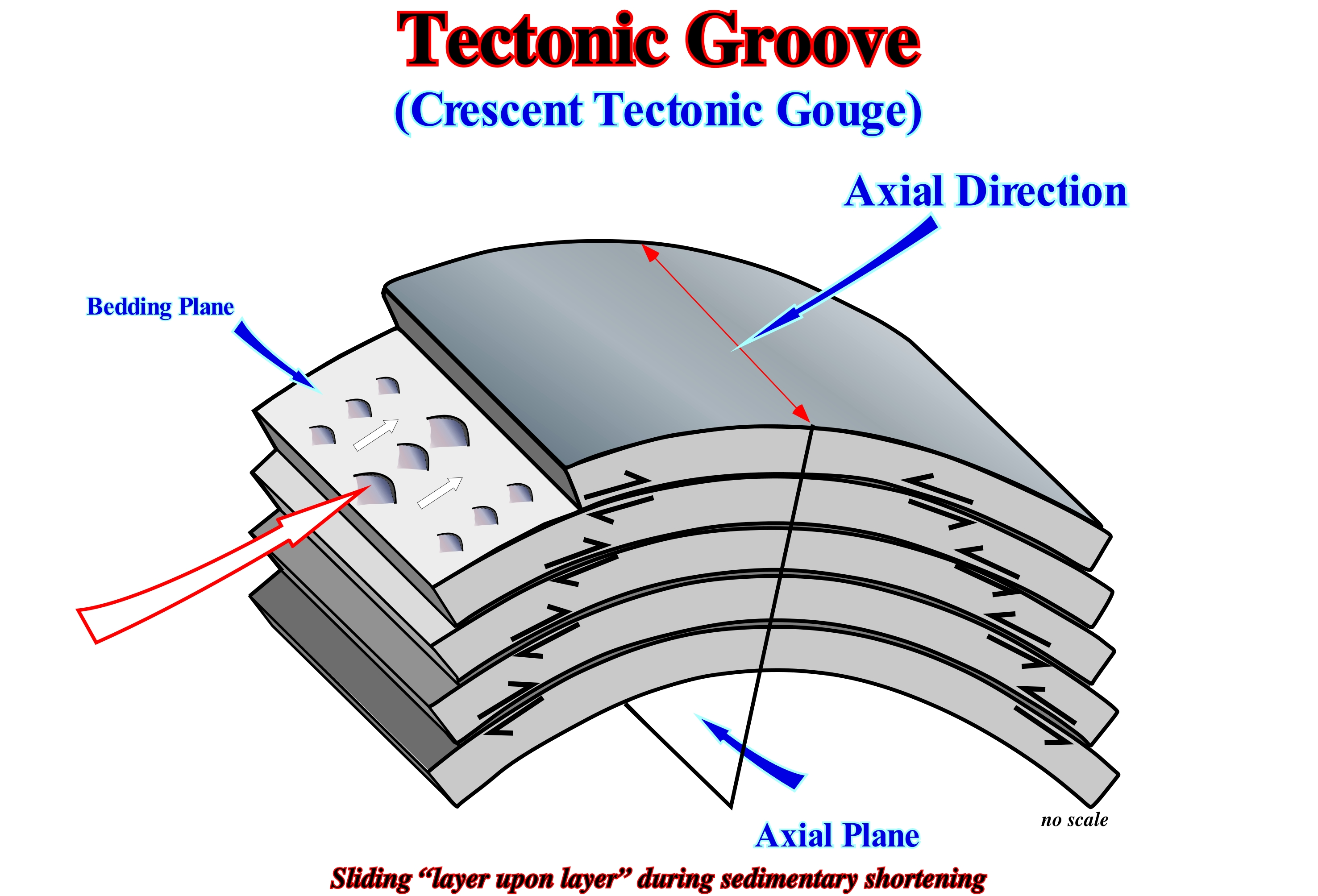
Tectonic grooves and the importance of "layer upon layer" sliding in the Jurassic folds (from the Jura mountain belt) have been recognized for many years by the Swiss geoscientists (Wegmann, C. E., 1954). During a sedimentary shortening it is easy to see that the "layer upon layer" bending sliding functions, more or less, like the folding of a telephone directory where the pages (sedimentary layers) slide over each other. As illustrated in this sketch, it is the relative movement of the beds in direction of the anticline apex along the bedding planes that the forms the tectonic grooves. These structures are very useful in field geology, since they indicate, roughly, the axial direction and location of the anticline. At the beginning of the petroleum exploration, i.e., before the seismic reflection, the tectonic grooves, as well as, the drag folds (small folds that form on the flanks of the anticlines and whose vergence indicates the position of the apex of the structure) were fundamental to determine the location of the exploration wells. At that time of the petroleum exploration history, almost all geoscientists, if not all, used the anticline method in petroleum exploration (exploration was limited to onshore). They try to locate the apexes of the anticline structures (not to be confused with the antiform structures, which are lengthening structures and not shortening structures) in order to locate the testing exploration well. A well located on the apex of anticline (with an axial plane, more or less vertical) test all potential reservoir-rocks under optimal trapping conditions (structural traps). When a geoscientist found in an outcrop (bedding planes), tectonic grooves he deduced the axial direction and plunge of the anticline axis. The direction of the grooves is perpendicular to the axial direction and the plunging (dip of the base of the grooves, as in the glacial grooves) gives the direction of motion (sense)*. The same is true of the drag folds, in which the vergence is always towards the axial plane.
(*) The term "direction" was probably not the best choice of words. Consider this example - a car travelling at 30mph down Smith Street, heading west. Smith Street becomes the direction (or the defined path), west becomes the sense. Simply saying "30mph down Smith Street" would not be enough information. It all comes down to a poor choice of words (or change of meaning over time or a poor translation). In that regard, "orientation" is a better choice than "direction". (https://physics.stackexchange.com/questions/132189/what-is-the-sense-of-a-vector)
Tectonic Hinge....................................................................................................................................................................................Charnière (Tectonique)
Charneira (tectónica) / Charnela (tectónica) / Tektonische Gelenkpunkt / 构造铰链点 / Тектоническая точка изгиба / Cerniera (tettonica) /
Point of the sedimentary substrate where the flexural subsidence, measured in relation to a fixed reference plane, is zero.
See: « Subsidence »
&
« Foreland Basin »
&
« Flexural Subsidence »
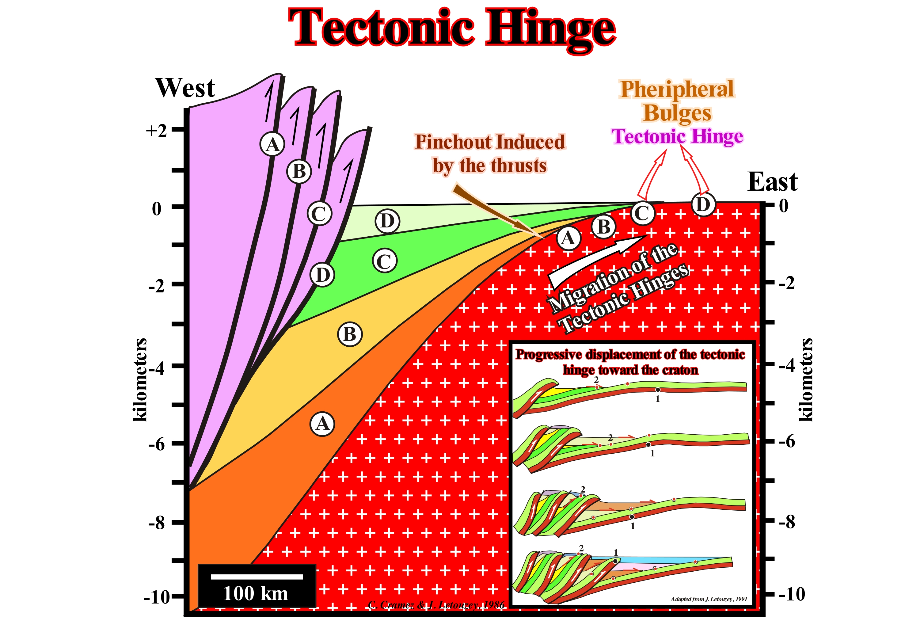
In this sketch of a foreland basin (Ampferer or A-type subduction zone), the bulge (D) is, approximately, the tectonic hinge. The bulge (D) is the result of a migration from the tectonic hinge to the craton, as the sedimentary shortening becomes accentuated. It is preferable to speak of shortening rather than compression, since there may be lengthening of the sediments with compressive tectonic stresses. What deforms the sediments are not the tectonic stresses, but the effective stresses (σ1, σ2, σ3), which is not the same thing. The onlapping on the western flank of the craton (sometimes called the platform) is caused by the eastward migration of the successive overloads induced by the thrusts. Each advance of the overload produces a subsidence of the foreland basin with creation of available space for the sediments (acommodation). Thus, a new sedimentary fill, divergent towards the thrusts, overlaps the previously deposited unit and the tectonic hinge and the bulge (when they are not coincident), move in opposite direction of the frontal thrust. Such a eastward displacement of the tectonic hinge (where subsidence is zero) produces a depression characterized by onlapping on the western edge. These onlaps, which in time tilt towards the mountains emphasizing the basal unconformity of the foredeep basin. In this tectonic model, it is assumed that each of the overloads A, B, C or D is exerted on a substantially sub-horizontal surface and that the sedimentary shortening is in sequence, i.e., that the most recent thrust near the craton. In the first phases of the foreland basin, the terrigeneous influx comes mainly from the craton (from East in this particular case). As the uplift increases, in association with the shortening induced by the thrusts, a terrigeneous influx coming from West becomes obvious. At a given moment, the two terrigeneous influxes are practically equal in importance, but in the upper part of the basin, the terrigeneous influx coming from the mountains becomes preponderant.
Tectonic Subsidence..............................................................................................................................................Subsidence tectonique
Subsidência tectónica / Subsidencia tectónica / Tektonischer Subsidenz / 构造沉降 / Тектоническое оседание / Subsidenza tettonica /
Total subsidence (sediment thickness plus water-depth) decreased by the effect of isostatic compensation (due to sedimentary overload) and increased by the compaction effect.
See: « Glacio-Eustasy »
&
« Subsidence »
&
« Flexural Subsidence »
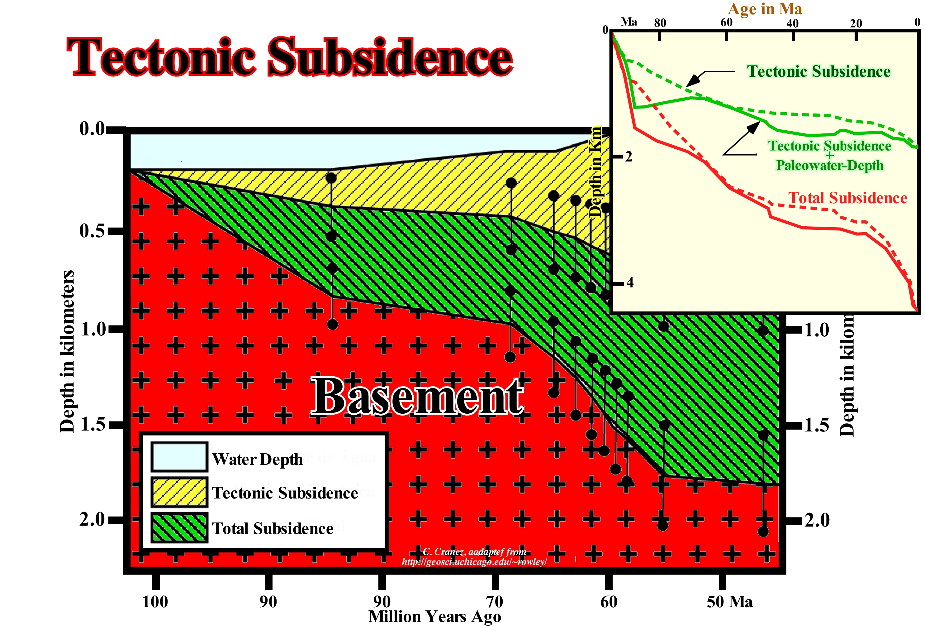
The tectonic subsidence, also called controlled subsidence, is different from the subsidence created by the isostatic effects associated with sediment and water column loading. It corresponds to total subsidence decreased of the effect of isostatic compensation* and increased by the compaction effect (chemical compaction encompasses the dissolution of minerals under pressure and mechanical compaction encompasses physical processes such as change in intergranular packing and deformation or breaking of individual grains). Tectonic subsidence is controlled by tectonic stresses that affect the way the lithosphere floats over the asthenosphere. The three main mechanisms that affect the isostatic balance between the lithosphere and the asthenosphere (more or less ductile land layer, which forms the upper part of the Earth's mantle, limited between approximately 30/130 km and about 670 km deep, rich in iron and magnesium silicates), which control the tectonic subsidence are: (i) Stretching (lengthening or enlargement) ; (ii) Cooling and (iii) Charging. The stretching of the continental lithosphere often results from the substitution of the dense continental lithosphere for the denser asthenosphere, which means that a stretched and thinned continental lithosphere sinks creating a tectonic subsidence (rift-type basins, backarc basin, cratonic basins, etc.). Cooling is associated with lengthening. During lengthening, the continental lithosphere (Earth's outermost solid layer formed by the Earth's crust and upper mantle) heats up, becomes less dense, and tends to rise due to the decrease in temperature (the final effect in a lengthened and heated lithosphere can be either a uplift or a subsidence). Cooling decreases exponentially with time. Cooling can produce significant subsidence several million years after the cooling has begun. Subsidence due to cooling is, especially, important in the divergent continental margins and in the cratonic basins. A tectonic loading can also produce significant subsidence. For instance, tectonic loading on accretional prisms or sedimentary arcs (sediment prisms, located on the overriding plate, accumulating sediments, rocky debris resulting from erosion, chemical precipitation from oceans, valleys or rivers or layers of loose particles, when the energy of the transporting fluid decreases) transported by the plunging lithospheric plate, foreland basins and mountain belts (thrust quite frequent) forces the continental lithosphere to sink. However, as the lithosphere responds in a flexural way to loading, subsidence occurs not only under loading but in a much wider region around loading. A stretching or lengthening of the lithosphere, characterized by a certain lengthening factor B (deformation length which determines the amount of lithosphere which can be vertically tapered during extension), creates isostatic compensation. This isostatic compensation produces an uplift of the mantle of the asthenosphere (thermal anomaly that is translated by a rise of the isotherms). Since the thermal anomaly below the thinned lithosphere begins to cool, the increase in density pushes the lithosphere downward, causing another episode of subsidence (thermal subsidence). This second subsidence occurs exponentially and much more slowly than early rapid subsidence (differential subsidence), since it attempts to maintain isostatic equilibrium while the submerged asthenosphere cools. The lengthening of the lithosphere ceases as soon as thermal sinking begins. This model proposed by Dan P. Mckenzie (1978) explains the lengthening (extension) of the lithosphere that creates the elongated basins by normal faults (rift-type basins) that are, later, fossilized by basin sediments induced by thermal subsidence.
(*) For more than two centuries geoscientists have advanced the hypothesis that the shorelines, in various areas, had changed over geological time. In Geology, the term isostasy is used to designate the state of gravitational equilibrium, and its changes between the lithosphere and the Earth's asthenosphere. Two great theories proposed by J. Pratt and G. Airy have explained to the compensations that occur in depth of the superficial reliefs according to their weight (density). According to Pratt, the mountains corresponded to areas where the lithosphere would have widened and, therefore, the larger the mountain, the greater would be the dilation and the smaller the density would be, and thus, in depth, there would be a compensation surface where the value of gravity would be homogeneous (this hypothesis was abandoned). According to Airy, the mountains corresponded to rock masses with constant density (d = 2.67) and, therefore, the higher the mountain, the greater its penetration into the asthenosphere (d> 3,3) and, therefore, the different elevations in the terrestrial surface would be compensated by different penetrations in depth, assuming the existence of a compensation surface. The Airy hypothesis is now the most accepted since it allows to explain the variation of the thickness of the lithosphere, which reaches about 70 km in the Himalayas, whereas under the years it rarely exceeds 10 km in the oceans.
Tectonics...................................................................................................................................................................................................................................Tectonique
Tectónica / Tectónica / Tektonik / 构造 / Тектоника / Tettonica /
A branch of geology that studies the deformations of the Earth's crust (or other planets), as well as, the forces and movements that created such deformations (tectonic structures).
See: « Continental Collision »
&
« Tectonic Subsidence »
&
« Relative Sea Level Change »
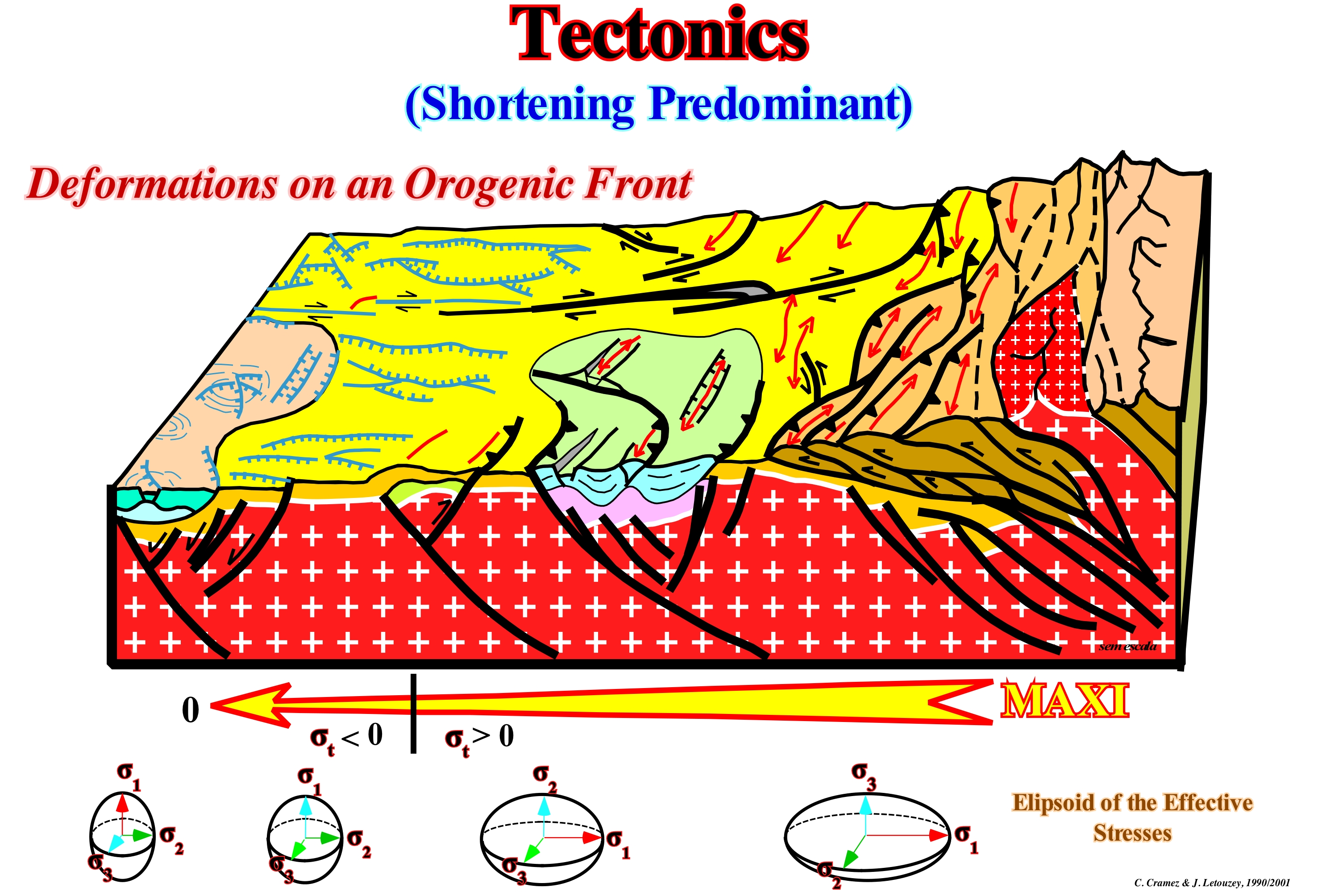
Tectonics studies orogenies, formation of cratons and structural zones (terranes*), as well as earthquakes and volcanic belts, which affect, directly, a large part of the Earth's population. Tectonic studies are very important for understanding geomorphological patterns and guide geoscientists in the search for raw materials such as petroleum, metallic ores, etc. Neotectonics is the branch of tectonics, which studies recent geological phenomena. The tectonic studies also apply to the study of the Moon and other planets, despite the fact that most bodies do not have active plate tectonics. Since the late 1960s, "Plate Tectonics" has become the dominant paradigm for explaining the origin of the forces responsible for the tectonic characteristics of continents and oceans. The deformation of the rocks can be explained by the action of three types of tectonic regimes: (i) Shortening (compression) ; (ii) Extension (lengthening) and (iii) Slippage (strike-slip). However, as illustrated, it is important not to forget that what deforms the rocks are not the tectonic stresses (σt), which can be positive (compression, σt > 0) or negative (traction, σt < 0). The deformed rocks are the effective stresses (σ1, σ2, σ3), which correspond to the three main axes of the ellipsoid resulting from the combination of the tectonic effort (σt), the geostatic pressure (σg) and the hydrostatic pressure (σp). The tectonic effort is a vector, which acts, more or less, parallel to the geoid. The geostatic pressure (σg) at a given point is the weight of the sedimentary column and is expressed by a biaxial ellipsoid. The hydrostatic pressure (σp) or pore pressure, at a given point, is the weight of the water column (in an open system), which fills the porosity and is translated by a uniaxial ellipsoid (a sphere). The combination of these three efforts results in a triaxial ellipsoid (effective stress ellipsoid) whose axes are σ1, σ2and σ3. As illustrated in this scheme, rocks can be extended (extension) when the tectonic stress is positive (compression, σt > 0), so it is preferable to speak of shortening or enlargement and to avoid the expression compressive tectonic regime.
(*) Fragment of crustal material formed on, or broken off from, one tectonic plate and accreted or sutured to crust lying on another plate. The crustal block or fragment preserves its own distinctive geologic history, which is different from that of the surrounding areas—hence the term "exotic" terrane. The suture zone between a terrane and the crust it attaches to is usually identifiable as a fault. (https://en.wikipedia.org/wiki/Terrane)
Tectono-Eustasy........................................................................................................................................................................Eustasie tectonique
Eustasia Tectónica / Eustasia tectónica / Тектоника eustasy / 构造eustasy / Тектоническая эвстазия / Tettonica eustastismo /
Eustatism induced mainly by tectonic factors. It results, mainly, from the volume variations of the ocean basins produced by vertical (epirogenic) and horizontal (orogeny) movements. This type of eustatitism is frequent at the beginning of the divergent margins, in the foreland basins and in the folded mountain ranges.
See: « Relative Sea Level Change »
&
« Eustasy »
&
« Foreland Basin »
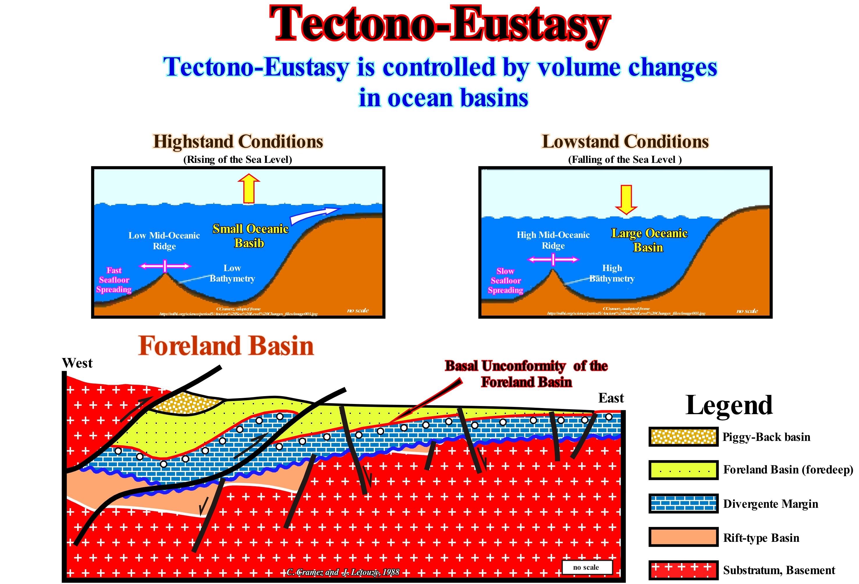
Prior to the advent of sequential stratigraphy, geoscientists studied the causes and amplitude of the sea level changes, defined as uniform global mean sea level variations, which are considered as being, more or less, equal to the geoid in the oceans, but different in most continental areas, where they can be very different. The mean sea level can be estimated, at a given location, based on hourly observations made over a sufficiently long period (more or less 30 years)*, since sea level is affected by tides, wind, atmospheric pressure, local differences of gravity, temperature, salinity, subsidence, etc. Fairbridge (1961) used the terms Tectono-Eustasy, Judgment-Eustasy and Glacio-Eustasy, as the main components of sea level variations. Sea level variations associated with tectono-eustasy result from changes in oceanic volume induced by the volume of the oceanic ridges, by the subduction amplitude in A- and B-Type subduction zones. Tectono-Eustasy just makes sense if the amount of water in all its forms (liquid, solid and gaseous) has been constant since the Earth's formation (around 4.5 Ga). As this conjecture, to this day, has not yet been refuted, as illustrated in this figure, when the volume of the oceanic basins increases (slow sea floor spreading), geoscientists assume that the absolute sea level falls. Otherwise, when the volume of ocean basins decreases, due to significant subduction or rapid sea floor spreading, they assume that the absolute (eustatic) sea level rises. In sequential stratigraphy, there is a great divergence among geoscientists regarding the parameter responsible for the cyclicity of the sedimentary deposits. The great majority think, like P. Vail, that eustasy (variations in absolute or eustatic sea level) is the main factor of falls of the relative sea level (local sea level, referenced to the top of the continental crust or to the sea floor), that is, of the erosional surfaces (unconformities), which limit stratigraphic cycles. However, they think that tectonics (subsidence or uplift of the sea floor) is the parameter, which creates most of the available space for sediments (acommodation)and that when eustasy and tectonics combine, eustasy creates the cyclicity of relative sea level changes. They invoke the rate of eustatic changes is much greater than the rate of tectonic variations. In the sedimentary basins associated with the formation of the oceanic crust (basins in extension), the arguments invoked by P. Vail's school are difficult to refute. However, in the sedimentary basins associated with the formation of the megasutures** and in particular in the basins of foreland, as illustrated in this figure, it is probable that tectonics could be the main factor of the cyclicity. In basins where subsidence, induced by overloading of thrusting, may vary more rapidly than eustasy, even when the basin is marine, which is not always the case. In the geological sketch illustrated in this figure several types of basins of the classification of the sedimentary basins of Bally and Snelson (1980) can be recognized: (i) A substrate, which when sedimentary in nature corresponds, in general, to a flattened mountain belt (supercontinent) ; (ii) Rift-ype basins, created during the lengthening of the lithosphere of the underlying supercontinent, i.e., induced by differential subsidence, generally, in a nonmarine environment ; (iii) Divergent continental margin, created by a thermal subsidence during the dispersion of the individualized continents by the breakup of the lithosphere of the supercontinent, which precedes the divergent margin, which postdate the formation of the rift-ype basins ; (iv) Foreland or foredeep basin created by the weight of the thrusts, i.e., by a flexural subsidence and (v) Piggy-Back basin or Transported basin created by the sediment removal induced by shortening. It is in the last two types of sedimentary basin that tectonics can be preponderant over the eustasy in the evolution of the stratigraphic cycles. The absolute or eustatic sea level is the supposed global and referenced to the Earth's centre. The absolute sea level is dependent on: (i) Tectono-Eustasy, which is controlled by the volume variation of the ocean basins in association with oceanic spread in the following of the breakup of the supercontinents ; (ii) Glacio-Eustasy, which is controlled by the variation of ocean water volume as a function of the amount of ice ; (iii) Geoidal-Eustasy, which is controlled by the distribution of ocean water caused by variations in the terrestrial gravity field, and (iv) Steric sea level rise or thermal expansion of the oceans.
(*) An average whether it is sea level or temperature, to have meaning it must cover a rather long period. The World Meteorological Organization (WMO) recommends that it covers 30 years: from there one can speak of « normal ».
(**) Earth moving regions (folded and faulted mountain belts) that testify to the complexity of the accretion and deformation phases undergone by the geological bodies in the regions where compressional tectonic regimens are predominant. The term megasuture was first used in 1975 by A. Bally. Although the compressional tectonic regimes associated with the subduction zones are predominant in the formation of a megasuture, extensional regimes and the formation of sedimentary basins also play an important role.
Temperature Log..........................................................................................................................................Diagraphie de température
Diagrafia de temperatura / Perfil de temperatura / Temperatur-Protokoll / 温度日志 / Диаграмма температурного каротажа / Registro di temperatura /
Log indicationg the temperature variations inside a well. It shows the temperature anomalies in relation to an average gradient (geothermal gradient). Most of the temperature anomalies are associated with fluid inputs into the well from the geological formations or, on the contrary, induced by leakage of well fluids (mud) into the geological formations.
See: « Electric Log »
&
« Geothermal Gradient »
&
« Potential Source-Rock »
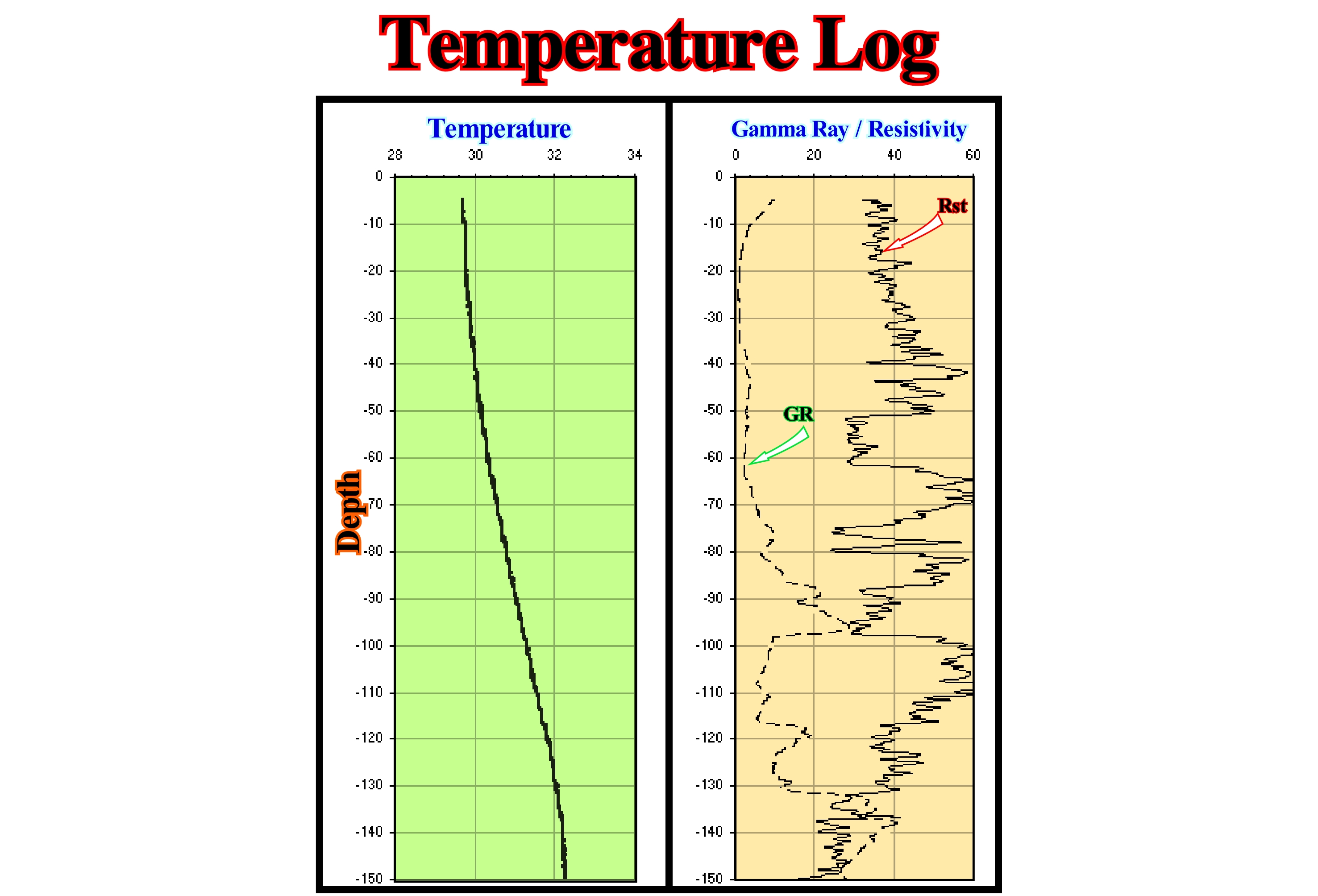
The geothermal gradient is the rate of increase of temperature per unit of depth (usually 100 meters) on Earth. Far from the limits of tectonic plates, the average value of the geothermal gradient is 25-30° C per kilometre depth. In petroleum exploration, the geothermal gradient, which varies, appreciably, from one region to another, is, usually, measured to determine the temperature at the bottom of a well after drilling. This operation requires that the probing fluids reach the ambient temperature (comfortable temperature for man and that is between 18° and 28° C), which is difficult to obtain for several reasons. In this figure (Pataya well, Cue Pro City (Mekong Delta, Vietnam), the temperature log is shown on the left. The geothermal gradient in this region is about 30° C per 1,000 meters. Due to the annual temperature variation, the natural temperature increases with depth as can be observed above, above all, from 20-30 meters deep. Deviations from the increase in normal temperature may indicate vertical movements of water, both in the well and adjacent rocks. Gamma ray and resistivity diagrams are shown on the right. There are three diagrams to determine the electrical resistivity of rocks crossed by a well: (i) Normal, (ii) Lateral and (iii) Induction. In the normal (conventional) log, it records the gamma ray and resistivity diagrams are shown on the right. An electrical potential is determined and current flow is determined between an electrode placed on the probe and another electrode on the surface. For this, a pair of electrodes (current and register) is placed on the probe to measure the resistivity variations of the geological formations as the probe is withdrawn to the surface. The distance between the current electrode and the recording electrode, which may be variable, determines at what distance from the well walls the resistivity is measured. The distances between the three electrodes can be 40 cm (small normal), 2.63 meters (long lateral).
Tephra.................................................................................................................................................................................................................................................................Tefra
Tefra / Tefra / Sediments Pyroklastisches / 火山喷发碎屑 / Тефра (продукты вулканических извержений) / Tefrite /
General term, used to express the pyroclastics* of a volcano.
See: « Tephrachronology »
&
« Subaerial Lava (SDRs) »
&
« SDRs »
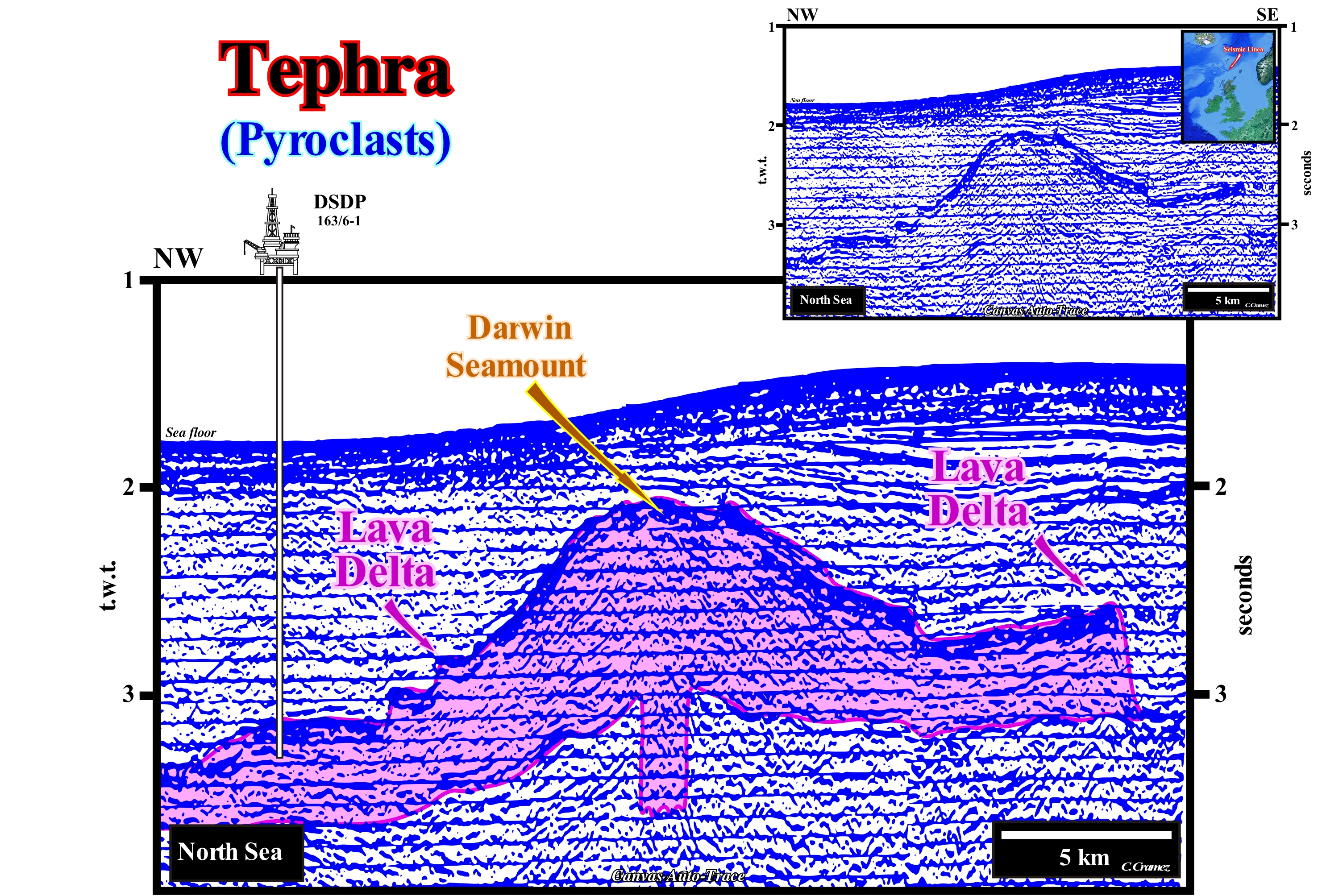
The tephra encompasses all the material, which falls from the atmosphere, produced by a volcanic eruption, regardless of composition and size. Typically, tephra has a felsic or rhyolitic composition (SiO 2> 69%), since most volcanic explosions are produced by viscous felsic magmas very rich in silica. Certain volcanologists call the volcanic fragments transported by air pyroclasts or simply clasts. As long as the clasts fall on the ground, they remain as tephra, unless, when they are sufficiently hot, they associate with one another to form a pyroclastic rock or tuff. Following an eruption, the distribution of the tephra follows evidently the law of universal attraction. Larger blocks are the first to fall to the ground and thus they are located near the chimneys or volcanic crevices, while the finer fragments travel farther, such as ashes that can travel for thousands of kilometers and even go around the Earth, as happened, probably, with the eruptions associated with the volcanic mountain of Darwin, illustrated in this Canvas auto-trace of a detail of a North Sea seismic line. The ashes can remain in the stratosphere (atmosphere range between 20 and 80 km altitude where the temperature increases from -60° C at the base to 0° C at the top) for several weeks. When, after a large eruption or small eruptions, more or less simultaneous, large amounts of tephra accumulate in the atmosphere. They can reflect sunlight into the atmosphere and produce a significant temperature drop resulting in a major climate change (volcanic winter). The tephra when mixed with rain forms the so-called acid and snowfall rains. Tephra fragments can be classified by size. Thus it can be distinguished: (i) Ash, when the particles have a diameter of less than 2 mm ; (ii) Lapili or volcanic embers when the particles have a diameter between 2 and 64 mm and (iii) Volcanic bombs when the particles have a diameter greater than 64 mm. In archaeological and geological studies, the use of tephra layers, which have their own chemical and temporal characteristics, is known as tephrachronology. With respect to volcanic tufts, as to the composition of the fragments, they can be of three types: (i) Crystalline volcanic tufts, which have more than 75% of volcanic crystals and fragments of ejected crystals ; (ii) Lithic volcanic tuffs, where crystalline rock fragments generated from the rapid cooling of volcanic materials predominate and (iii) Vitreous volcanic tufts, when more than 75% of their composition consists of hardened volcanic ash. The tephra can produce enormous tragedies, as for example happened to the south of Naples where the ruins of Pompey are. This great Roman city, which was about 1.5 km long by 900 meters wide and which was inhabited by about 25,000 people, was completely destroyed by the fall of hot ash during the eruption of Somma in 79 BC* . The eruption began on October 24 and tons of lapili and hot ash fell over the city. The cork of the volcanic chimney exploded, expelling enormous amounts of pumice and ashes in a very short period of time. The plumes of volcanic dust reached several kilometers in height, the pumice fell on Pompeii, while the ashes carried by the wind lay more to the south. Some inhabitants, in panic, fled, but preferred to take refuge in the cellars where they were suffocated by toxic gases. The amount of hot ash in the streets was so great that most of the inhabitants died either asphyxiated or burnt. Another well-known example is the eruption of the Tambora volcano (Sumbawa island, Indonesia): in 1815, the Tambora ejected 150 km3 of burning tephra, releasing 10 27 ergs. It is the strongest historical eruption. She made 92,000 victims. About 10,000 of the direct effects of pyroclastic flows, streams of hot mud and ash precipitation, but 82,000 died of starvation after the disaster. All crops and all pastures were destroyed. Near the volcano, deposits of volcanic products reached 20 m thick. At 140 km distance, on the island of Lombok, the thickness of these deposits reached 50 cm. The darkness caused by the precipitation of the volcanic dust was total during 4 days up to 500 km of the volcano. The explosions were heard up to 1,500 km from the volcano. (http://www.chambon.ac-versailles.fr/science/geol/volc/tephra).
(*) Pyroclasts or tephra are any volcanic fragment that was hurled through the air by volcanic activity. A pyroclastic eruption is one in which the great majority of activity involves fountaining or explosions. A pyroclastic deposit is the resulting layer or pile of material that has fallen to the ground by one or many pyroclastic eruptions. A pyroclastic rock is the hardened, solidified, or compressed version of an originally loose pyroclastic deposit. (http://counter-revolutionaries/Create-are-pyroclasts).
(**) Mount Vesuvius called "Mount Somma" before the eruption of the year 79.
Tephrachronology......................................................................................................................................................................Tefrachronologie
Tefracronologia / Tefracronología / Tephrachronologie / 火山碎屑年表 / Тефрохронология (хронология вулканических обломков) / Tefricronologia (cronologia degli piroclastici) /
Science that uses tephra, i.e., pyroclastic deposits as time horizons.
See: « Tephra »
&
« Subaerial Lava (SDRs) »
&
« SDRs »
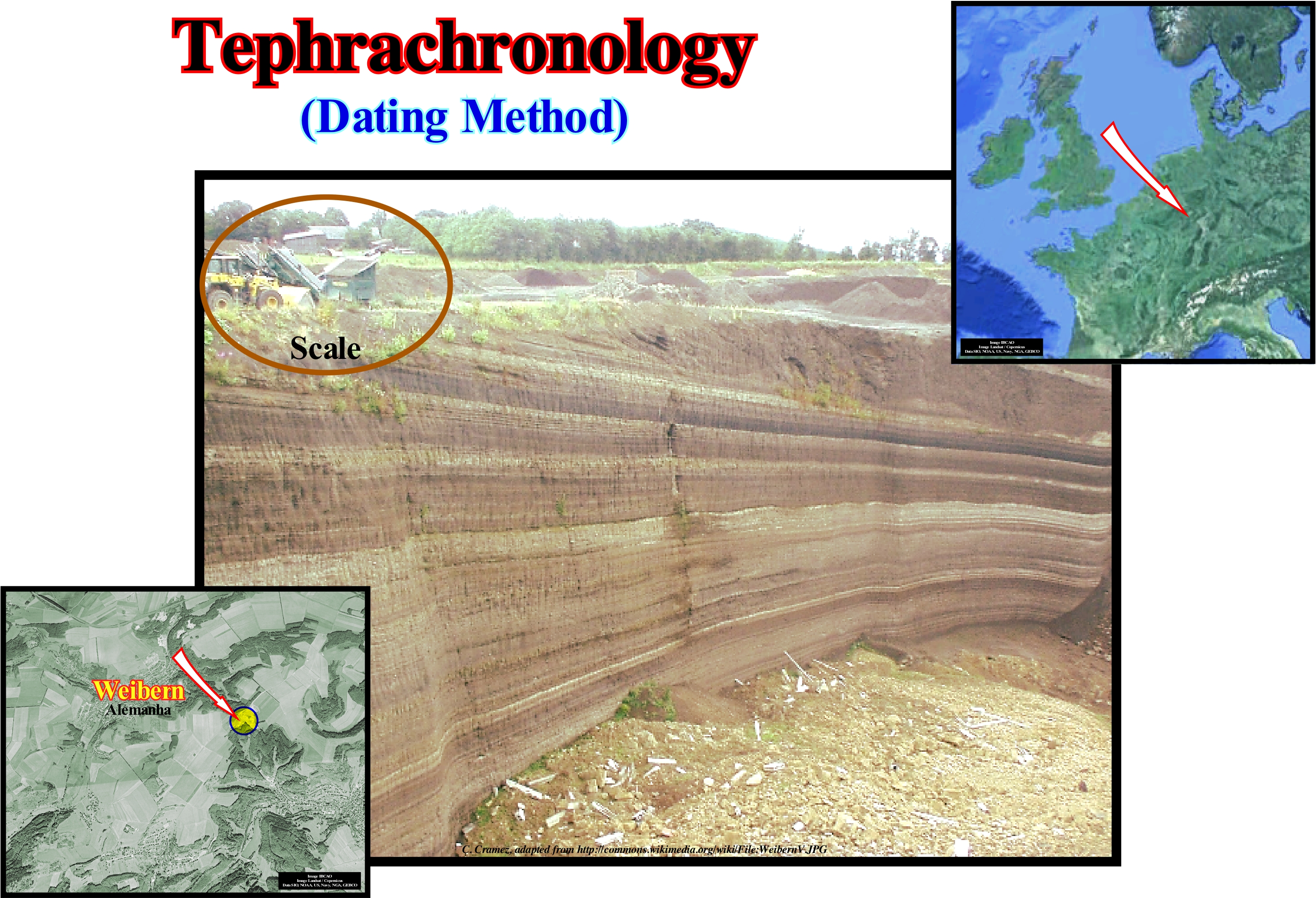
Tephrachronology is a geochronological technique that uses pyroclastic layers from a single eruption to create a chronological structure in which paleoenvironmental or archaeological records can be located. Each volcanic event has a unique chemical fingerprint that can be recognized in associated deposits. The main advantages of this technique are that the layers of volcanic ash are, relatively, easy to identify within the sedimentary series and that the pyroclastic layers are almost, instantaneously (geologically), deposited over a large area (in 1815, the thickness of the ash from the eruption of Tambora, Indonesia, which ejected about 150 km3 of burning tephra, reached 20 meters near the volcano and about 50 cm to 140 km away on the island of Lombok). This means they create time markers that can be used to verify or corroborate other dating techniques, relating sequences very separate from each other in a unified time-line that relates climatic sequences and volcanic events. However, it should be borne in mind that one of the problems in tephrachronology is that the chemistry of pyroclasts can change over time, which is, especially, true for basaltic pyroclasts (rich in magnesium and iron silicates and low in silica). Pyroclastic horizons provide a refutation test for paleoclimate reconstructions made from palynology, varves, ice deposits and marine deposits. The pioneer in the use of pyroclastic layers as marker horizons to establish chronology was S. Thorarinsson, who studied the pyroclastic layers of Iceland. Since the 1990s, techniques developed by Chris S. M. Tourney and other geoscientists to extract pyroclastic horizons invisible to the naked eye (cryptopyroclast) have revolutionized the application of tephrachronology. This technique is based on the density difference of the fragments of the micropyroclasts and the sediments of the host matrix. It was this technique that allowed the discovery of Vedde volcanic ash (thin Microbioclasts layer that was described in the sediments of Lake Sutherland, Scotland and dated by the radiocarbon as having an age of about 10,300 years BC) not only about the region of Brittany, but also in Sweden, the Netherlands, Lake Soppensee located in the Canton of Lucerne (Switzerland) and two locations on the Karelia Isthmus in Baltic Russia. Tephrachronology, in fact, is an example of sediment dating by age equivalence. Recall that there are four major families of rock dating methods (https://moodle2.units.it/pluginfile.php/88407/mod_resource/ content/1/GQt% 20D% 20Datazioni.pdf): (I) Radiodation, which are based on the decay of some unstable chemical elements that are measured or that measure the decay effect on the crystal structure (in both cases the rate of decomposition is well known and absolute dating can be said) ; (II) Stratigraphy, which are based on the accumulation of regular deposits of annual sediments or of biological material, at annual levels ; (iii) Relative age, either by stratigraphic approach or by assessment of the degree of change (chemical or biological indicators, hydration of obsidian, diagenesis of amino acids, etc.) ; (iv) Age Equivalence, which are based on the simultaneous presence of the same horizons in different and separate stratigraphic sequences, is more or less similar to the stratigraphic correlation through the fauna. This type of dating method to be useful should be calibrated with an independent method (tephrachronology, paleomagnetism, etc.). The tephra encompasses all the material, which falls from the atmosphere, produced by a volcanic eruption, regardless of composition and size. Typically, tephra has a felsic or rhyolitic composition (SiO2> 69%), since most volcanic explosions are produced by viscous felsic magmas very rich in silica. Certain volcanologists call the volcanic fragments airborne pyroclasts or simply clasts. As long as the clasts fall on the ground, they remain as tephra, unless, when they are sufficiently hot, they associate with one another to form a pyroclastic rock or tuff. Following an eruption, the distribution of the tephra follows evidently the law of universal attraction. Larger blocks are the first to fall to the ground and thus they are located near the chimneys or volcanic crevices, while the finer fragments travel farther, such as ashes that can travel for thousands of kilometers and even going around the Earth, as probably happened with the eruptions associated with the volcanic mountain of Darwin (North Sea), or the Tambora volcano (Indonesia).
Terminal Moraine..................................................................................................................................................................Moraine Terminale
Moreia terminal / Morena terminal / Endmoräne / 终碛 / Конечная морёна / Morena terminal /
Moraine formed at the end of the glacier. It marks the maximum thicknening (extent) of the glacier and forms, more or less, perpendicular to the glacier valley. It corresponds to a large mound of debris and marks, generally, to the limit between coarse and irregular remains and the beginning of fluvioglacial sediments.
See: « Moraine »
&
« Glacier »
&
« Recessional Moraine »
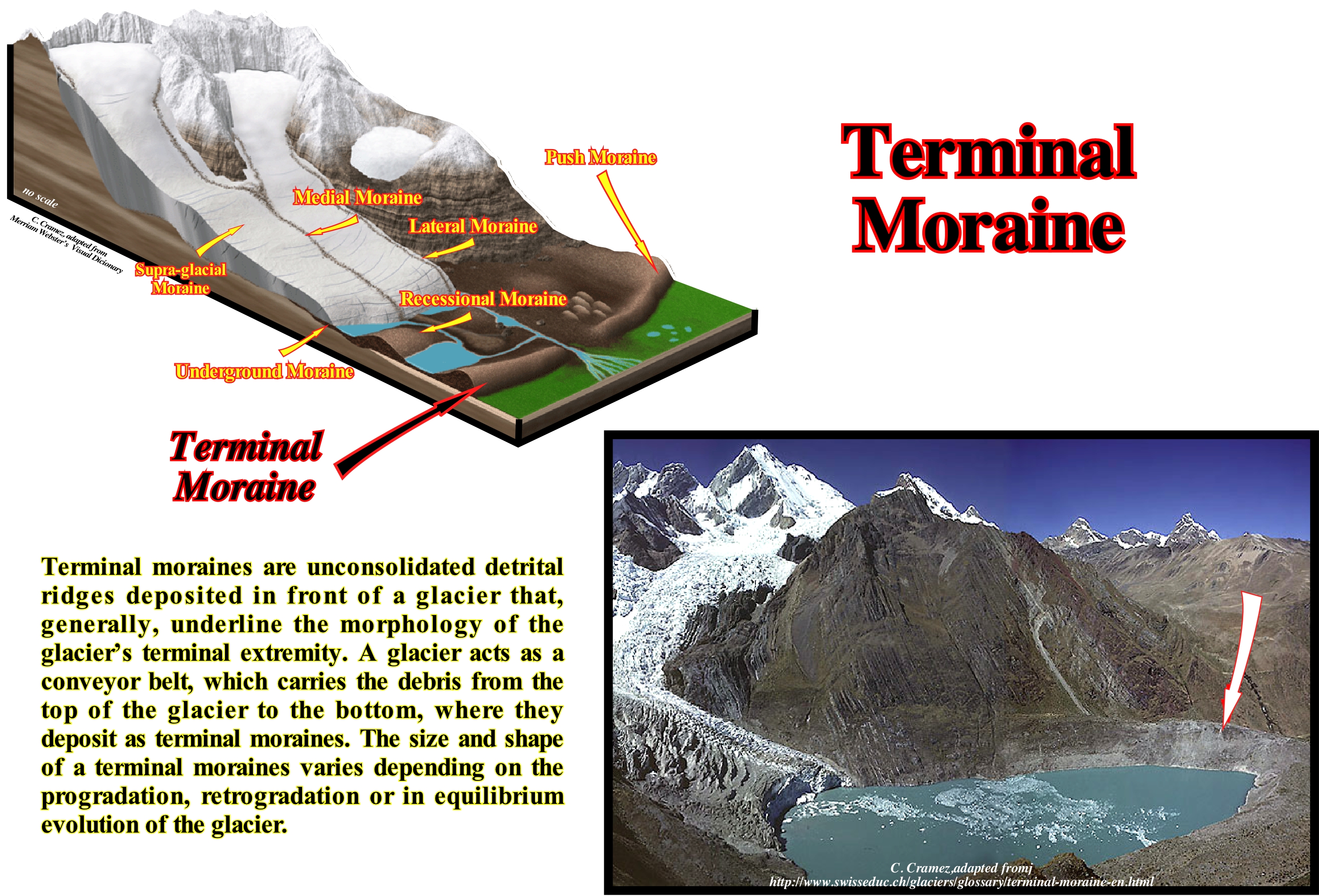
As illustrated in the small diagram, the classic image of the front of a glacier corresponds to the succession of: (i) A terminal depression of excavation ; (ii) A strong slope from which the frontal moraine rises above terminal depression ; (iii) A ridge of the frontal moraine ; (iv) A soft slope of the downhill side (downstream) of the moraine due to transport of the moraine material through the melt water. This set forming the outwash (fluvio-glacial) complex is, in fact, a very theoretical model. Many alpine Quaternary glaciers left a terminal depression occupied by a deep lake, but Alaska glaciers do not have these characteristics, as well as the inlandsis. As for the transition cone extended by the fluvial waters in front of the terminal moraine, it is, rarely, found in nature. The most frequent case is that of a river gorge dug in the moraine and ejection fan below, where the stream of water leaves the moraine. The classical image supposes that the construction of the moraine and the dispersion of the debris is contemporary, but in reality, the construction of the moraine suppose a slow melting of the ice, whereas the dispersion of the debris suppose a fast fusion. The two phases are not contemporary, they have to be different. The fluvio-glacial materials deposited at the front and below the frontal moraines, sometimes, form layers of coarse material at the foot of the mountains and thin material in front of the regional glaciers ("sandur" of the Icelanders). Piedmont alluvial mantles, such as the great quaternary glaciers of the Alps, were dissected by post-glacial erosion and now form terraces, still sharper than the sandur. The finer glacial materials deposited at the front of the glacier are taken up by the wind during the same glacial phase forming the "loess *", which often forms far from the glacier under characteristic conditions of the periglacial system.
(*) Sedimentary detrital rock formed by the accumulation of mud derived from wind erosion in the desert and periglacial regions.
Terrigeneous Sediment........................................................................................................................................Sédiment terrigène
Sedimento terrígeno / Sedimento terrígeno / Terrigen sediment / 陆源沉积物 / Терригенные осадки / Sedimenti terrigeni /
Sediment formed by continental sedimentary particles (practically almost all clastic particles).
See: « Sediment »
&
« Deposition (clastics) »
&
« Deposition (carbonates) »
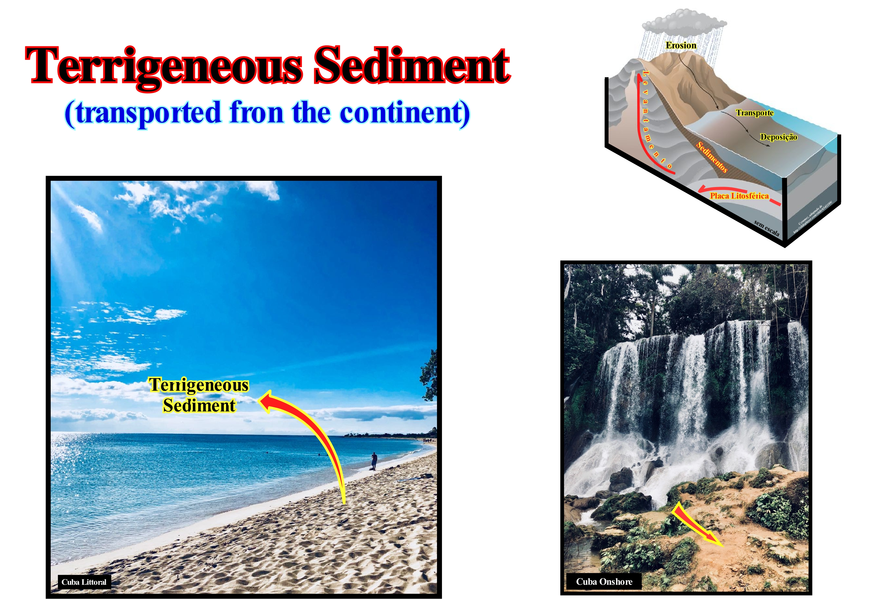
In geology, terrigeneous sediments are formed of sedimentary particles derived from the erosion of rocks on land, that is, formed in terrestrial environments. About 75% of the sediments are formed by terrigeneous sedimentary particles. The main terrigeneous sedimentary particles are sand, mud, mud, etc., which are carried by the rivers seaward where they settle. The composition of the terrigeneous sediments is related to the rocks that created the sedimentary particles. The origin of the sedimentary particles is very varied, such as volcanoes, weathered rocks (granites and gneisses), dust, glaciers, icebergs, etc. The deposition of the terrigeneous sedimentary particles is mainly done on the continental shelf. Many of the terrigeneous sedimentary particles that reach the continental shelf are, often, deposited in submarine canyons that develop on the continental slope and in submarine fans in the abyssal plain. Turbidity or turbidite currents transport the terrigeneous sedimentary particles to the deep parts of the sedimentary basins where they deposit the sediments either in the form of submarine basin floor fans or slope fans cones (filling of channels, depressions and natural marginal dikes). These types of currents are formed mainly during significant relative sea level falls, that is to say, falls that put the sea level under the basin edge. This type of relative sea level fall exhumes the continental shelf (when the basin has a platform) and/or the upper continental slope, which, of course, increases the sedimentary terrigeneous influx. Turbidite deposits (submarine fans) are the only depositional systems that deposit during relative sea level falls. All other systems (deposited upstream of the continental edge) require an increase in acommodation, that is, an increase in the space available for the sediments, which is induced by a combination of eustasy and tectonics (subsidence or uplift of the sea floor). In highstand geological conditions, i.e, when the sea level is higher than the basin edge (do not confuse the basin edge and continental edge, although in some cases they may coincide), the terrigeneous influx of important rivers can induce turbidite currents and the subsequent deposit of submarine fans in the deep part of the basin.
Terrigeneous Supply.................................................................................................................................................Apport sédimentaire
Acarreio terróigeno / Aporte sedimentario / Sedimentversorgung / 沉积物供给 / Осадочный нанос / Apporto solido /
One of four major factors that control the geometry of stratigraphic cycles and, in particular, the geometry of the sequence-cycles. The other three main factors are: (i) Tectonics ; (ii) Eustasy and (iii) Climate. The interaction between tectonics (subsidence or uplift of the sea floor) and eustasy (variations of absolute or eustatic sea level) generates relative sea level changes, which control the available space for sediments (mainly shelfal accommodation). The terrigeneous supply or influx determines how much of the available space is filled. Synonym wit Sedimentary Influx or Sedimentary Supply.
See: « Accommodation »
&
« Marine Regression »
&
« Transgression »
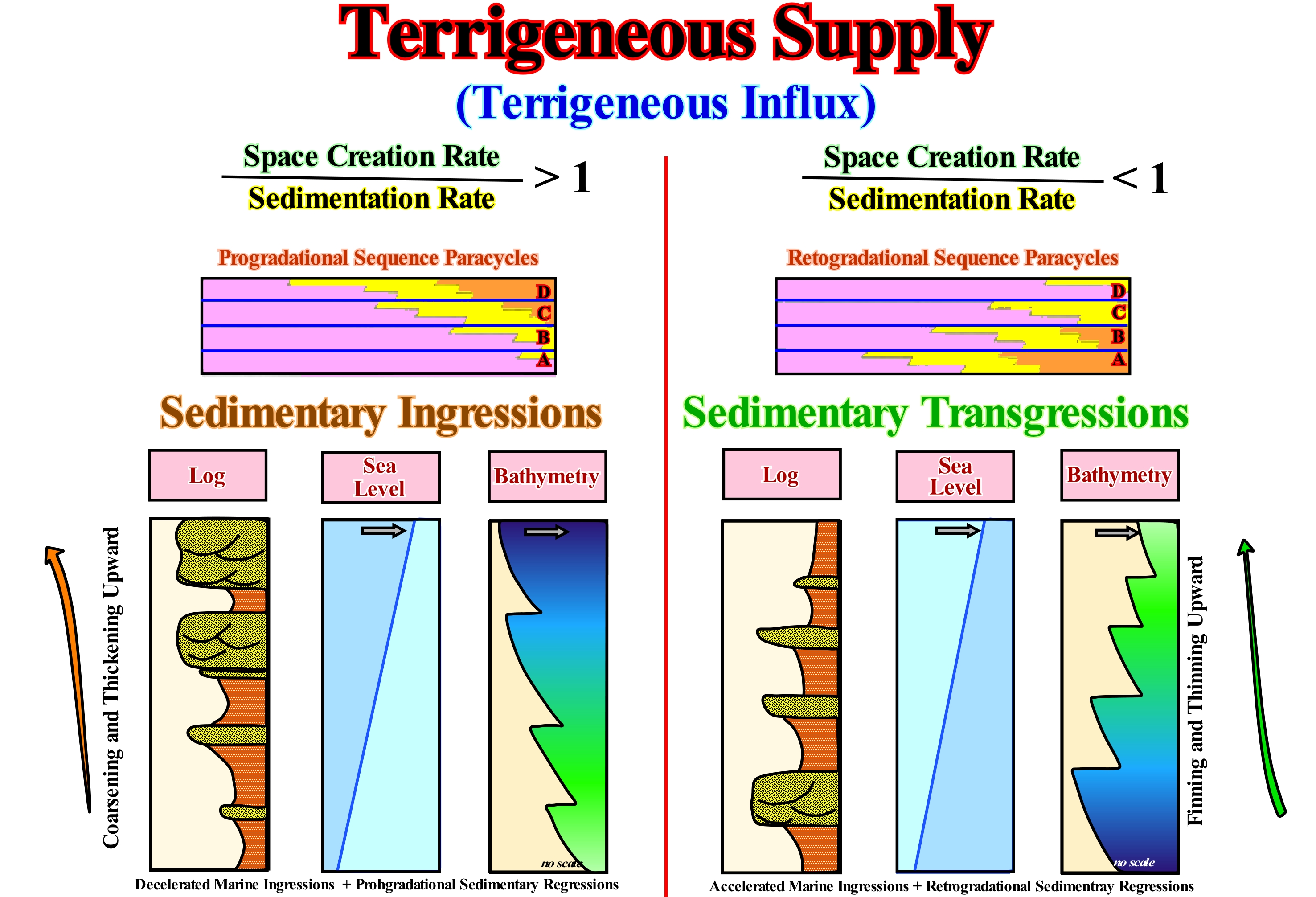
When the relationship between the rate of creation of available space for the sediments (accommodation) and the sedimentation rate is greater than 1 (> 1), the deposits have a, globally, progradational geometry and have coarsening and thickening upward pattern. They form increasingly important sedimentary regressions. On the other hand, when the relationship between the rate of creation of available space (combined action of tectonics and eustasy) and sedimentation rate is less than 1 (<1), deposited sediments, generally, have a retrogradational geometry. They form sedimentary transgressions, i.e., a set of increasingly important marine ingressions and increasingly smaller associated sedimentary regressions, with a finning and thinning upward sedimentary grain pattern. When within a sequence-cycle, the sedimentary charge is constant, a series of relative sea level rises (*) is in acceleration (increasingly important marine ingression) of the increasing and concave segment of the relative sea level change curve, develops sedimentary transgressions. Overall, the shoreline moves continentward as the shelf increases (**). On the contrary, for a relative sea level rise, in deceleration (set of decreasing marine ingressions), the shoreline moves seaward and the continental shelf extension decreases progressively (crescent and convex segment of the relative sea level changes curve). This is what the geoscientists call a sedimentary regression. In other words: (i) When the terrigeneous influx is sufficient for the depositional coastal break of the depositional surface moves seaward, a sedimentary regression develops ; (ii) When the terrigeneous influx is not sufficient, increasingly smaller sedimentary regressions, that collectively form sedimentary transgressions, are produced. In both situations, creating available space for the sediments, induced by a relative sea level rise, is necessary. Within a sequence-cycle, in order to have deposition upstream of the basin edge, the relative sea level has to rise, i.e., the available space for the sediments has to increase. However, during sedimentary transgressions, relative sea level rises are in acceleration, while during sedimentary regressions relative sea level rises are in deceleration. At each relative sea level rise in acceleration, the shoreline moves continentward, which increases the spatial extent of the shelf. As the extent of the continental shelf increases, the available terrigeneous influx is, usually, not sufficient for a particular sequence-paracycle to be larger than the preceding one. In the case of sedimentary regressions, the opposite is true. There is always more terrigeneous influx than is necessary to fill the available space, which forces the coastal deposits to prograde reducing the extension of the platform as the relative sea level rises in deceleration. To summarize: (i) A set of retrogradational and coarsening and thickening upward sequence-paracycles results from an increase in the rate of space creation available for each sequence-paracycle higher that of the constant terrigeneous influx ; (ii) A set of retrogradational sequence-paracycles in which each paracycle has a constant thickness (marine ingressions of more or less constant importance) results from a constant rate of increase in the space of accommodation between sequence-paracycles, but with a decrease in the rate of the terrigeneous influx ; (iii) A set of aggradational sequence-paracycles (more or less constant shoreline position) results from a balance between the terrigeneous influx rate and the rate of accommodation increase ; (iv) A set of fining and thinning upward progradational sequence-paracycle, results from a rate of creation of available space between the sequence-paracycles smaller than the constant rate of terrigeneous influx (if the paracycles are coarsening upward stratigraphic the admissions are increasing ); (v) A set of progradational sequence-paracycles without aggradation results from a constant available space and a continuous terrigeneous sediment ; (vi) A set of progradational sequence-paracycles with a negative aggradation of the shoreline (forced regression) results from a more or less constant rate of accommodation creation.
(*) Local sea level referenced to any fixed point on the Earth's surface, which is the result of the combined action of tectonics (subsidence or uplift of the sea floor) and absolute (eustatic) sea level, which is supposed to be global and referenced to the Earth's centre.
(**) The continental edge coincides with the shoreline during the 2nd phase of the high level prism (PNA), i.e., particularly true on the seismic lines. However, taking into account the seismic resolution, a basin without shelf may, actually, have a continental shelf with a lower water-depth than the seismic resolution. The basin edge is the continental edge when the basin has a continental shelf.
Tertiary..................................................................................................................................................................................................................................................Tertiary
Terciário / Terciario / Tertiär / 第三纪 / Третичный период / Terziario /
Geological time interval, more or less, between the end of the nonavian dinosaurs* and the beginning of the recent glacial age, i.e., roughly between 65 Ma and 1.8 Ma (millions years ago).
See: « Eon »
&
« Geological Tine Scale »
&
« Geological Time »
The Tertiary is the principal and longest period of the Cenozoic era (Tertiary plus Quaternary). The Cenozoic is one of the three major subdivisions of animal history. The other two eras are the Paleozoic and Mesozoic. Certain geoscientists, such as C. Emiliani (1992), also consider the Cryptozoic, which is sometimes called Precambrian, although, strictly speaking, the Precambrian implies all the time before the Cambrian including the Gamowian (between 4.7 and 16.5 Ga) and the Planckian (between 16.5 and 16.5 Ga). The Planckian characterizes the cosmological time (between t = 0 and t = 5.390, 10-44 seconds). The Cryptozoic encompasses the time between the formation of the solar system (end of the Gamowian, 4.7 Ga) and the beginning of the Cambrian (0.59 / 0.57 Ga). The Cryptozoic is formed by Hadean (4.7 / 3.8 Ga), Archean (3.8 / 2.7 Ga) and Proterozoic (2.7 / 0.57 Ga). The Tertiary begins with the end of the Cretaceous and the extinction of non-avian dinosaurs until the Quaternary (appearance of the benthic foraminifera Hyalinea baltica in the Mediterranean and important glaciations in the Northern Hemisphere). The Tertiary is considered as the time of the mammals, although the history of these animals began long before the Cenozoic. The Tertiary is, sometimes, subdivided into two subperiods: (i) Paleogene and (ii) Neogene. The Paleogene is composed of three epochs: (a) Paleocene ; (b) Eocene and (c) Oligocene, while Neogene is composed of two: (1) Miocene and (2) Pliocene. It was during the Tertiary that the Gondwana continent finally fractured completely, and that India collided with Eurasia, while Antarctica, which was already separated from Gondwana, drifted to its current position. By the end of the Tertiary, about 3 million years ago, the closure of the sea passage between North and South America seems to have created favourable conditions for the development of the important glaciations that occurred in the Northern Hemisphere. The first important glaciation occurred about 2.36 Ma. Since this first glaciation, the astronomical movements of the Earth (Milankovitch cycles) seem to have timed the succession of the glacial ages.
(*) Dinosaurs can be divided into (i) avian dinosaurs, or birds and (ii) nonavian dinosaurs, which are all dinosaurs other than birds.
Tethys* Sea................................................................................................................................................................................................................Mer de Téthys
Mar de Tétis / Mar de Tétis / Tethys (Ozean) / 特提斯洋 / Тетис (океан) / Tetide, Oceano Tetide /
Sea, between the NE Gondwana and SE Laurasia, which replaced the Paleotethys ocean (formerly the Suess' Sea of Tethys, i.e., the Paleozoic Ocean, between Gondwana, Central Europe, Iberia, China and Central Asia). The Tethys Sea began to form in the south of the Paleotethys since the Cimmerian plate was individualized (Permian/Triassic). The Tethys Sea expansion forced the Cimmerian plate to collide with the Laurasia, to finally the Tethys Sea replace, completely, the Paleotethys.
See: « Supercontinent »
&
« Rheic Sea »
&
« Iapetus Sea »
In 1893, using the fossils found in the Alps and Africa, E. Suess advanced a hypothesis in which he admitted that there had been a, relatively, shallow sea in the eastern part of the Pangea supercontinent between the Laurasia (Euroamerica) small supercontinent and the Gondwana small supercontinent, which at that time were still connected. Suess called this sea, Tethys Sea (which today is called Paleotethys). Later, the plate tectonics theory disputed and in some cases refuted many of the conjectures of Suess's theory, even suggesting the existence of a large mass of older water, which many geoscientists continue to confuse with the Tethys Sea of Suess, since it is also called Sea of Tethys **. The sea proposed by Suess corresponds, practically, to the ocean that today is called Paleotethys. In fact, during the Cambrian, the great ocean was the Panthalassa, which covered most of the southern hemisphere and surrounded the Pangea supercontinent that existed at the end of the Paleozoic. The Panthalassa was divided into two main ocean basins: (i) Pacific Basin corresponding roughly to the present Pacific Ocean and (ii) Paleotethys basin which had a chiselled wedge shape in the southeast of the Pangea supercontinent. The movement of the African continent has almost led to the total closure of the Tethys Sea, of which the Mediterranean, among other water-bodies, is one of the last vestiges. The Pangea breakup has, necessarily, created other ocean basins (including the Atlantic Ocean and the Arctic Ocean), which has, significantly, altered ocean circulation and, subsequently, global climatic conditions (https: //fr.wikipedia.org / wiki / Panthalassa). In the Northern Hemisphere, Prototethys, the Iapetus Sea (which existed between 600 and 400 million years ago, between the Neoproterozoic and Paleozoic periods and which formed due to the separation of Proto-Laurasia***) and the Khanty Sea (ocean between the Baltic continent and Siberia, north of Panthalassa and NE of Prototethys) continued to expand until the end of the period. However, since the idea of Suess as a whole was revolutionary, it is generally credited for the discovery of both water-bodies, which is not true. At present, the vast majority of geoscientists think that about 250 Ma, during the Late Permian, a new ocean began to form in the southern part of the Paleotethys Ocean. A mid-oceanic ridge formed along the southern continental shelf of the Pangea supercontinent (NE of the small supercontinent Gondwana) individualizing a new lithospheric plate that was denominated Cimmeria (in homage to the old people who lived in the North Caucasus in century VIII and VII before of Christ, usually associated with the ancient Cimmeria or Crimea). This small lithospheric plate moved northward for about 60 My as the sea floor spreading induced by the new mid-oceanic ridge forced the bottom of the Paleotethys Ocean (North of the Cimmeria) into subduction under the eastern and northern part of the Pangea supercontinent (Laurasia). All this not only provoked the collision of the Cimmerian with the Laurasia small supercontinent (Cimmerian orogeny), but also caused the total opening of the Tethys Sea and the closing of the Paleotethys Ocean, which was, practically, replaced by the Tethys Sea. At present, India, Pakistan, Indonesia and the Indian Ocean are in the area, formerly, occupied by the Tethys Sea. Note the collision term used here, since it does not correspond to a kinetic energy**** change (the energy that is related to the state of motion of a body) in deformation energy, as when two automobiles bump against each other or when a car crashes into a wall, where the impact energy is almost totally absorbed by the plasticity of the hull). In plate tectonics kinetic energy does not play any role. Throughout a lithospheric plate the effective efforts are, practically, the same. The rocks deform when they lose resistance to deformation, which happens inside a lithospheric plate if, for various reasons, the temperature and pressure increase, locally, over the resistance limit.
(*) In Greek mythology, Tethys is the mother of Achilles and one of the daughters of Neree and Doris (sister of King of Scyros, Nicomède).
(**) In Greek mythology, Tethys was a titanesse, personifying the fecundity of water, which feeds bodies and forms the sap of vegetation, daughter of Uranus (the starry Sky) and Gaia (the Earth). From the union of Tethys with his brother Ocean were born the three thousand oceanids, who had three thousand rivers as children.
(***) Small supercontinent, which formed in the SE part of Pannotia, near the South Pole, when this supercontinent fractured.
(****) There are just two types of energy, the kinetic energy, that is, the ability to do work through the movement and the potential energy, i.e., the ability to do work through the position. Although we, often, meet terms such as electrical energy, chemical energy, nuclear energy such things do not, really, exist. They are just practical abbreviations for specific combinations of the kinetic energy and potential energy. The electrical energy, for instance, is only the potential energy of negative charge electrons in the presence of positive charges. The exception to this universality of the kinetic energy and potential energy is the energy of electromagnetic radiation, such as the energy of light transported from the Sun to Earth and which heats us or aliments photosynthesis. (Atkins, Peters, 2003- Le doigt de Galilée (Dix grandes idées pour comprendre la Science). Dunod, Paris 2004. ISBN 2 10 007338 9)
Thallosocratic........................................................................................................................................................................................Thallosocratique
Talassocrático / Talosocrático / Thallosocratic (der ozeanischen Kruste) / Thallosocratic (大洋地壳) / Талассократический / Thallosocratic (della crosta oceanica) /
Adjective of thalassocraton, i.e., part of the oceanic crust. In contrast, epeirogen (or epirogen) is the adjective of epeirocraton (or epirocraton), i.e., a craton in the continental crust.
See: « Craton »
&
« Crust »
&
« Thallosocraton »
In the central part of this figure is illustrated a thallasocratic environment where not only several segments of the mid-Atlantic ridge (South Atlantic) are recognized, along which the oceanic expansion (sea floor spreading) is made, but also the transform faults and associated fracture zones. The transform faults are the faults that join two segments of the mid-oceanic dorsal and the fracture zones are areas of fragility that are inactive, tectonically, and that correspond to the traces of the old transform faults. By definition the transform faults are active. That means, the expansion movement occurs only between adjacent mid-oceanic ridge segments. Beyond these segments (continentward), there is no displacement. It can be said there is no significant strike slip movement along the fracture zones. However, along certain fracture zones vertical and horizontal movements are possible. The former appear to be induced by the cooling and increasing density of the oceanic crust (thermal subsidence) and the latter by the pressure induced by the difference in topography between the recent oceanic crust (near the ridge), which forms the oceanic mountains and the ancient oceanic crust (near the continent) that forms the abyssal plain. The displacement between the different segments of the mid-oceanic ridge, which is, sometimes, to the westward and sometimes eastward, as can be seen in this figure, is, purely, apparent. The breakup of the lithosphere was not done in a, more or less, straightforward way, to be later broken and displaced by strike slip faults with movements, sometimes opposite, but rather in a compartmentalized way due to the discontinuities and fragility zones of the continental crust. As continental crust fracture lines are, more or less, in continuity with ocean fracture zones, most geoscientists think are the discontinuities and fracture lines of the continental crust of the supercontinents that determined the breakup zones of the lithosphere and not the opposite, i.e., it is not the movement of the transform faults that induces the fracture lines of the continental crust.
Thallasocraton............................................................................................................................................................................................Thallosocraton
Talassocratão / Talosocratón / Thallosocraton (Craton der ozeanischen Kruste) / Thallosocraton (大洋地壳的克拉通) / Таллосократон / Thallosocraton (cratone della crosta oceanica) /
Craton (ancient and stable part of the lithosphere) forming part of the oceanic crust. An outmodded term that was used in opposition to epirocraton, which designates an old and stable area of the continental crust, i.e., a craton in the continental crust.
See: « Craton »
&
« Crust »
&
« Thallosocratic »
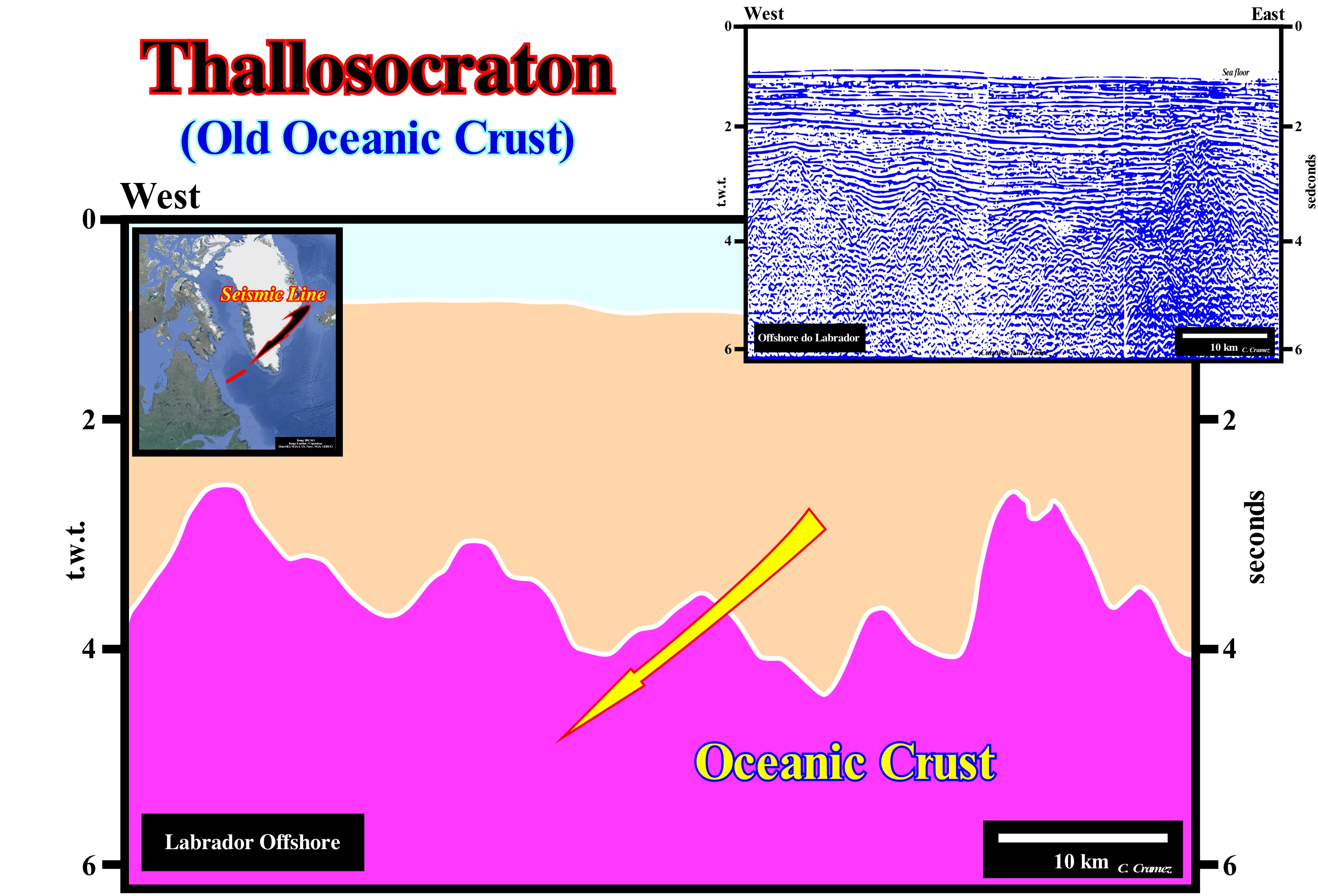
Before the advent of plate tectonics, the term thallasocraton was used to denote a stable, ancient area of the oceanic crust. The oceanic crust, illustrated on the tentative geological interpretation of this Canvas auto-trace of a Labrador offshore seismic line (not migrated, shot in 1970s), was considered as a thallassocraton. Since the plate tectonics paradigm has suggested that the oceanic crust is neither stable nor too old, which is not the case for a large part of the continental crust, there is no reason to consider a thallasocraton as the oceanic equivalent of an epirocraton (stable and ancient continental area). According to plate tectonics theory, since a supercontinent breaks and individualizes several continents, they are separated by breakup lines along which the material of the mantle comes to the surface and solidifies (oceanic crust) moving away, progressively, the newly formed continents from each other. The first phase of the sea floor spreading (oceanic expansion) is subaerial (expansion centres are not under water, which allows the volcanic material to flow and form huge packages of volcanic lava). However, quickly, i.e., more or less, 10 My, the expansion centres submerge and the volcanic material solidifies, immediately, forming pillow-lava deposits in the oceanic crust (the volcanic material can not flow under water). As the new oceanic crust forms, it pushes the oldest crust sideways and as well as the lithospheric plates with the continents . Over time, the oceanic crust cools, increases in density and, sooner or later, plunges beneath a lighter oceanic crust or continental crust, forming a subduction zone, along which it will be consumed by the mantle. By this mechanism, almost all the oceanic crust created during the oceanic expansion disappears during the agglutination of the continents, forcing the seas to close until a new supercontinent is formed. Thus, theoretically, today, it may be said, practically, all the Paleozoic oceanic crust was consumed.
Thallasogeneous (Process).......................................................................................................................................................Talassogénique
Talassogénico / Talassogénico / Thalassogenishe / Thalassogeneous(过程) / Талассогенный (процесс) / Thalassogénique (processo) /
Marine process, such as marine or submarine erosion.
See: « Deposition (clastics) »
&
« Deposition (carbonates) »
&
« Submarine Erosion »
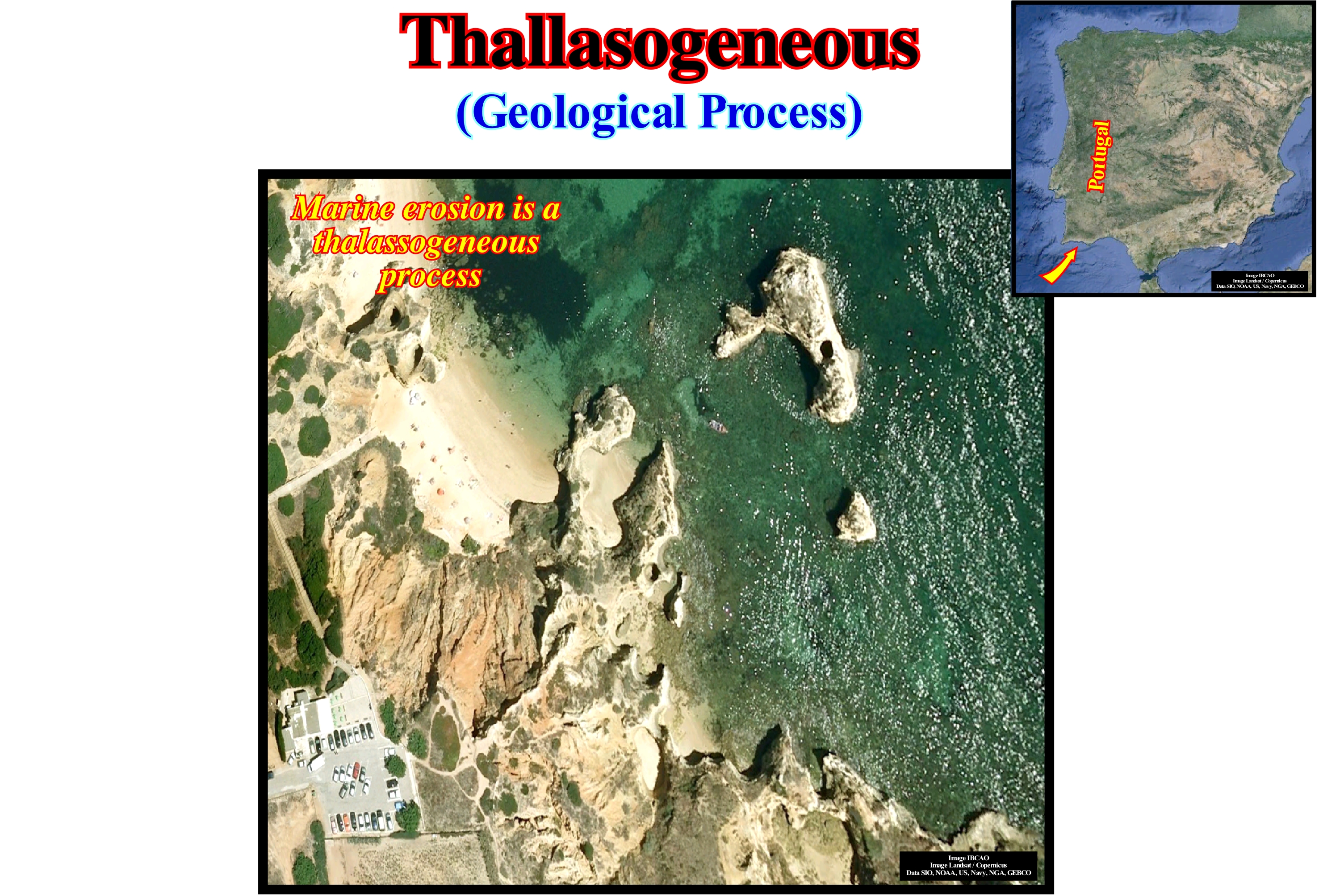
Erosion is the destruction of soil and rocks and their transport, usually made by rain-water, wind or by the action of ice, when it acts by expanding the material in which the water infiltrates and freezes. Erosion destroys the structures (sands, clays, oxides and humus) that make up the soil. These are transported to the lower parts of the reliefs and, in general, will silting the streams. Erosion destroys the soil and deteriorates the waters, which is a very serious problem for the whole world. Soil conservation practices should be adapted to minimize this important problem. In forest-covered soils, erosion is very small and almost non-existent, but it is a natural process that is always present and important for the formation of reliefs. The problem occurs when man destroys forests for agricultural use and leaves the soil exposed, because erosion becomes severe and can lead to desertification. Marine erosion is a long process of friction of sea-water with the rocks that turn into grains. This work is constant and acts on the coast, transforming the reliefs into the lowlands, due mainly to the action of two factors present in thermodynamics: (i) Heat* and (ii) Cold, responsible for the appearance of waves, currents and tides. Thallasogeneous processes occur both on rocky coasts and on sandy beaches. In the former the erosive action of the sea forms the cliffs. In the second occurs the retreat of the beach, where the sediments removed by the waves are transported, laterally, by the currents of coastal drifting. On sandy beaches, erosion is a serious problem for coastal populations. The damage can range from the destruction of homes and infrastructure to serious environmental problems. In order to delay or solve the problem, various protection measures can be taken, the main ones being coastal defensive constructions (rock-fills and spurs) and beach feedback. In Portugal, in the region of Aveiro, there is currently a worrying situation. The narrow coastal strip that separates the sea from the lagoon is dangerously close to the break. If this occurs, in addition to the populations affected, there will be a drastic change in the salinity of the lagoon, affecting the whole ecosystem that resides there.
(*) Neither the heat nor the work is an energy form. Both are methods to transfer energy from one place to another. Work is a method, heat is another. The energy can be transferred either through work or heat. Energy is conserved in the field of dynamics (movement of individual objects and the reciprocal conversion of kinetic energy and potential energy) and the thermodynamics of the reciprocal conversation and heat conversation.
Thalweg...............................................................................................................................................................................................................................................Thalweg
Talvegue / Thalweg, Vaguada / Talweg / 河道深泓线 / Тальвег / Fondovalle, Talweg /
The continuous and deeper line along a valley or a water-course. It corresponds to the line connecting the lowest points along a valley or the bed of a water-course. In geomorphology, the thalweg is the continuous line that follows the points of greatest dip or maximum descent. In a topographic map, the thalweg is always perpendicular to the contours lines.
See: « Point Bar (fossil) »
&
« Depositional Dip »
&
« Slope »
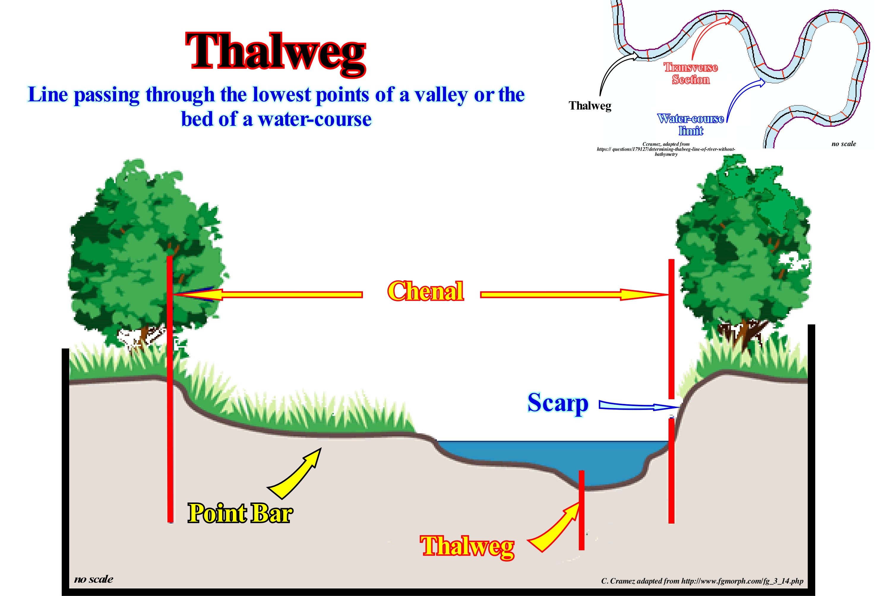
In this transversal profile of an active meander, the position of the thalweg relative to the river channel is perfectly individualized. The thalweg corresponds to the deepest part of the river-bed. Longitudinally, from the source to the mouth, the thalweg is marked by the line that passes through the deepest points of the river-bed. On the other hand, as shown, the thalweg does not always divide the channel of a water-course in half and symmetrical parts. In this particular case, it is much closer to the outer escarpment (erosion zone) of the meander than to the point bar. The river channel encompasses not only the active part (where the stream flows), but also the submerged area during floods. The term thalweg comes from the German term "thalweg," which means a path of a valley, i.e., the line of intersection of the two sides of a valley, along which a stream of water flows. Currents or water-courses have different names depending on their size and behaviour. A river, for instance, is an important water stream. A brook is a stream of water of little importance. A stream is a water-course smaller than a brook. A torrent is a stream of water that disappears during the dry season. In the deserted areas, torrents that incised bottoms more or less sub-horizontal flanked by cliffs are called arroyos (from the Spanish "arroyos") and which the Arabs call "widian" ("wadi" in the singular).
Thanathocenosis...............................................................................................................................................................................Thanathocénose
Tanatocenose / Tanatocenose / Tanathozönose (alle lebenden Fossilien in der gleichen Umgebung) / Tanathocoenosis (在同一环境中所有的活化石) / Tanathocoenosis (все живые ископаемые в тех же условиях) / Tanathocoenosis (tutti i fossili viventi nello stesso ambiente)
Association of carcases and or skeletons of organisms that lived in different or similar environments, but which, after death, were transported and accumulated in calm environments (deep-water, for instance), where, by diagenesis, they were transformed into biogenic rocks, such as diatomites, radiolarites and others.
See: « Detritus, Debris (geology) »
&
« Carbonate Sedimentation (principes) »
&
« Reservoir-Rock »
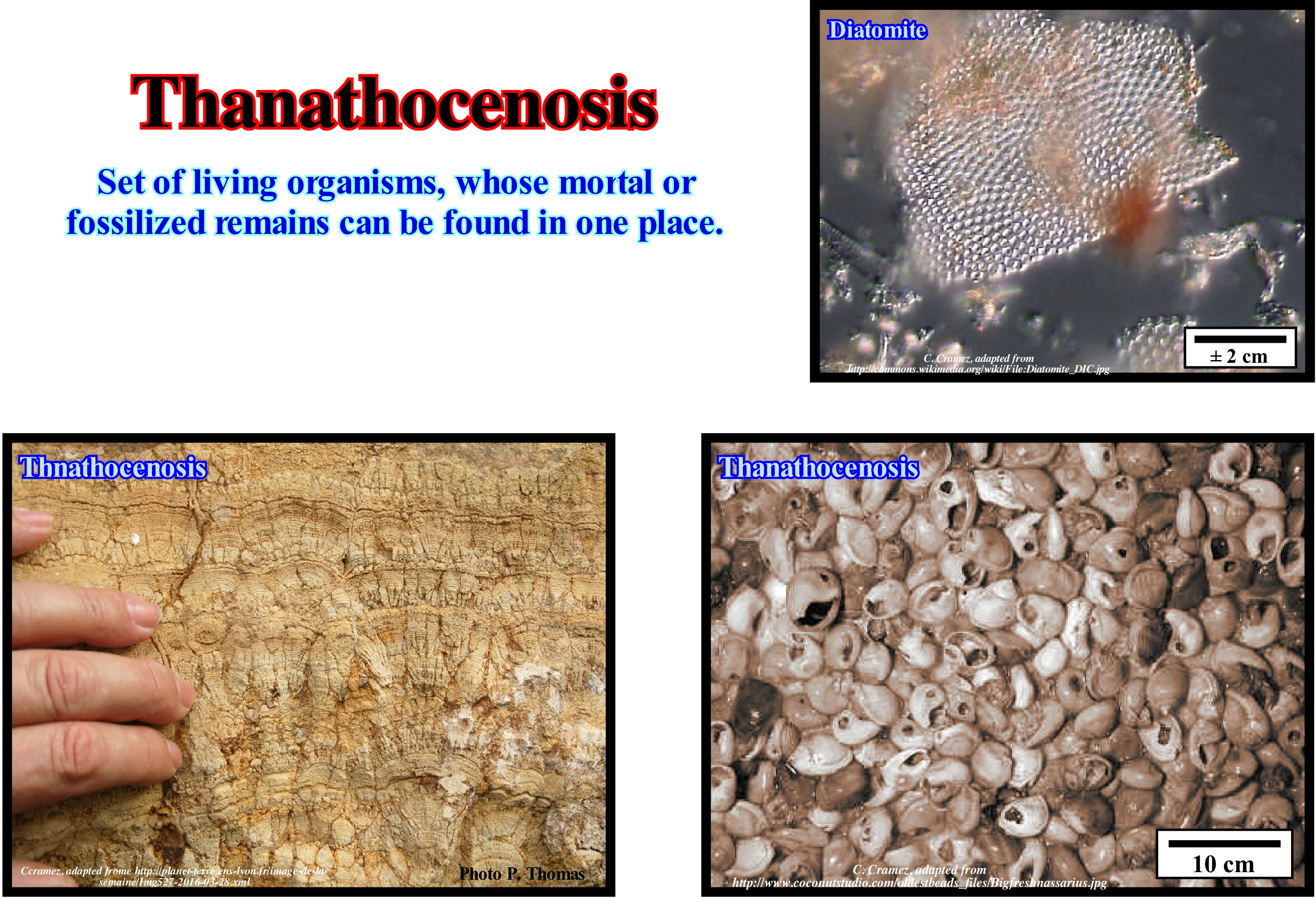
A thanathocenosis is often, but not always, the image of the biota of a site, namely, by the natural accumulation of the corpses of the animals that live there. However, circumstances may alter the accumulation of the remains, and lead to disturbances of the thanathocenosis, which reflect no more than an imperfect original biocenosis (set of living beings or populations occupying a natural area and the relations that are established between them). Certain types of remains may be the subject of wild predators, for example, which may, totally, deplete the maturation of one or more species or a variable proportion of individuals. Certain thanathocenosis are the result of particular phenomena of accumulation and do not reflect, as well, a part of the biocenosis. A thanathocenosis can be formed by a set of remnants of the meal of a carnivorous species, for example, or by an accumulation of corpses, as due to certain underwater currents. Natural pitfalls, such as tar pit, or network of wells and caves, may constitute thanathocenosis, particularly species rich, as carnivorous, because of the attraction may, for them, represent a natural accumulation of bodies. As in many other phenomena, man's action can lead to thaphocenoses (a set of living beings, i.e. individuals and species fossilized in the same rock or environment, which allows for the reconstitution of paleoenvironments), since it is one of the unique species to bury their dead, sometimes in the presence of remains of other living beings, which leads to original associations. The remains contained in a thanathocenosis may, according to environmental characteristics, be so intrinsic (fragility of bodies, presence or absence of soft tissues, bones, shells, etc.) to undergo the fossilization process to create a thaphocenoses, which reflects a altered thanathocenosis.
Theory of Evolution.................................................................................................................................................Théorie de l'évolution
Teoria da evolução / Teoría de evolución / Theorie der Evolution / 进化论 / Эволюционная теория / Teoria dell'evoluzione /
Life on Earth seems to have arisen through physical and chemical reactions and has developed through natural selection processes.
See: « Life »
&
« Homeostasy »
&
« Earth »
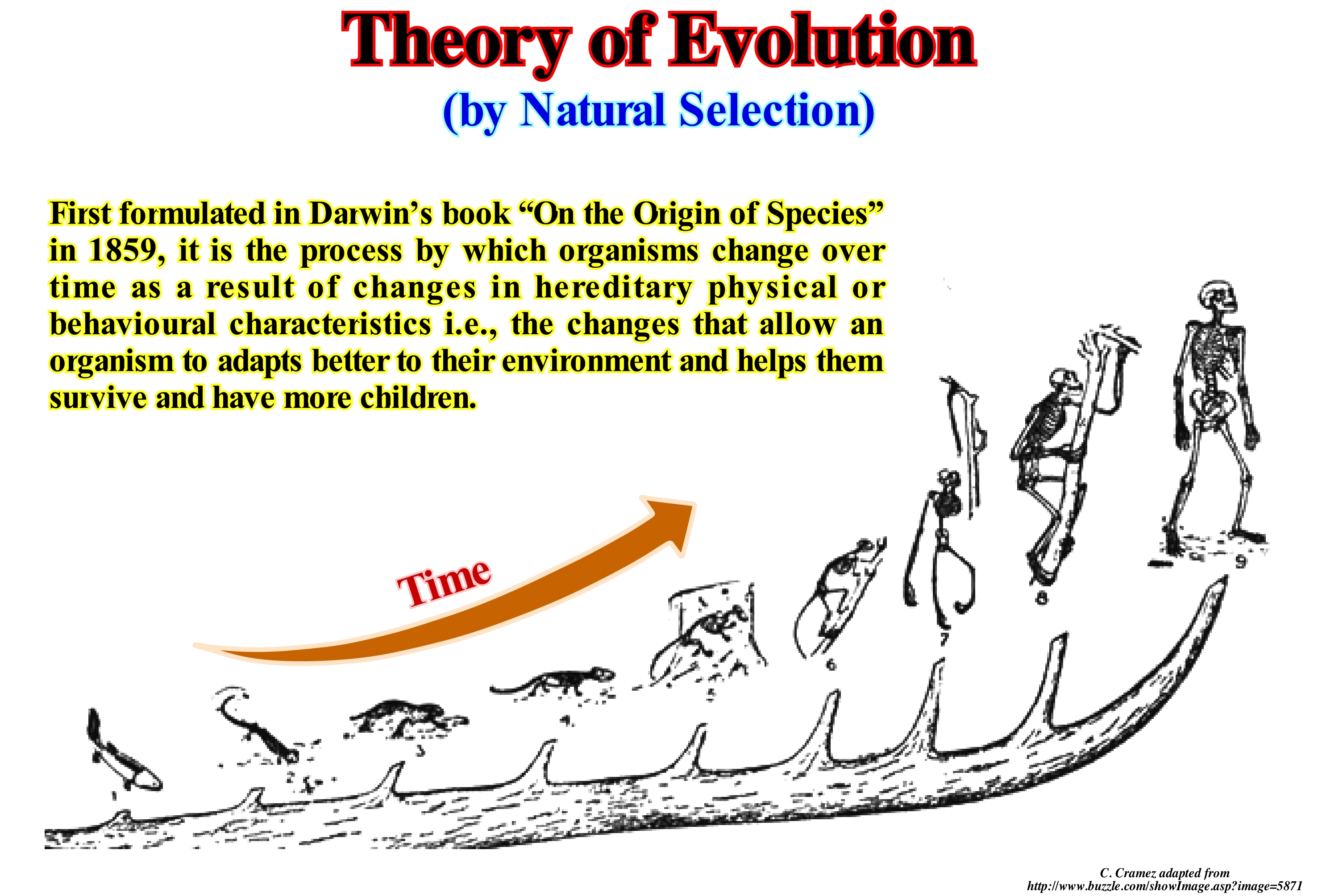
The theory of evolution explains the change in the hereditary characteristics of a population from one generation to another. This process causes the populations of organisms to change over time. One of the most interesting aspects of this theory is natural selection, which can be defined as the process by which genetic mutations, that improve reproduction, become or remain, more common in successive generations of a population. This mechanism has often been called "self-evident". It is probably the consequence of three main factors: (i) Existence of hereditary variations in populations of organisms ; (ii) Organisms produce more offsprings than they can survive ; (iii) These descendants have a variable ability to survive and reproduce. These conditions generate competition between organisms for their survival and reproduction. Organizations with characteristics that bring them some advantage over their competitors convey these advantageous characteristics, while features that confer no advantage are not passed on to the next generation. The central concept of natural selection is the evolutionary fitness of an organism, which measures the genetic contribution of one organism to the next generation, which is not the same as the total number of offspring. Aptitude measures the proportion of subsequent generations that carry the genes of an organism. If an allele (a sequence of a gene-DNA molecule located at the same locus and corresponding to different versions of the same gene) increases the aptitude more than other alleles of the same gene, then in each generation of hat allele will become more common within the population. These characteristics are said to be "selected for" or "positively". Examples of characteristics that may increase fitness are, for example, improved survival and increased fecundity. On the contrary, a lower ability caused by a less beneficial allele results in a decrease in the frequency of this allele: they are "selected against" or "negatively". The fitness of an allele is not a fixed characteristic. If the environment changes, the characteristics that were previously neutral or harmful may become beneficial or vice versa.
Thermal Anomaly (Wilson's cycle)................................................................................................................Anomalie thermique
Anomalia térmica / Anomalía térmica (ciclos de Wilson) / Thermische Anomalie / 热异常 / Термальная аномалия (аномальный перепад температур) / Anomalia termica /
Anomaly that produces the lengthening (extension, rifting) of the sediments of a supercontinent in a Wilson's cycle. The tectonic-stratigraphic phases of a Wilson 's cycle are: (i) Stable Continental Craton ; (2) Thermal Anomaly (hot spot) and Lengthening (rifting), which induces the formation of rift-type basins (usually halgrabens with opposite vergence on each side of the thermal anomaly) ; (3) Breakup (rupture) of the lithosphere, with creation of new oceanic crust and formation of two divergent margins and an ocean between them ; (4) Sea Floor Spreading that gradually transforms the young continental margins into mature margins due to the cooling and increasing density of the oceanic crust ; (5) Subduction, since the density of the oceanic crust becomes higher (the crust is divided into two parts and one of them plunges under the other creating a convergent margin and forming a volcanic arc and a mountain range on the overriding lithospheric plate) ; (6) Divergent Margin/Volcanic Arc collision and formation of a mountain range ; (7) Peneplanization and new subduction of the oceanic crust with the twin margin creating another convergent margin ; (8) Continent / Continent collision and closure of the ocean created between the two divergent initial margins and (9) New Stable Continental Craton.
See: " Wilson's Cycle "
Thermal Flow.................................................................................................................................................................................................Flux thermique
Escoamento térmico / Flujo termal / Wärmestrom / 热通量 / Тепловой поток / Flusso termico /
Heat flow rate through a unit area (J.m-2.s-1). The thermal flux is a vector quantity, i.e., a mathematical object that has both a length (or magnitude, norm or modulus) and a direction in space.
See: « Source-Rock »
&
« B-Type Subduction (Benioff) »
&
« Oil Window »
The profile of the thermal flow along this geological section of the island of Java (Indonesia) shows, clearly, maximum values to the vertical of the volcanic-arc associated to the subduction of the oceanic crust under the continental crust. North of the volcanic-arc, in the Bogor depression and in the Ardjuna geographic basin, the values of thermal flow are higher than in the south, either in the basin, accretion prism or oceanic crust. It is for this reason that in the north of the arc, the organic matter* of the potential source-rocks of the forearc basin (Bogor and Ardjuna) has matured and generated hydrocarbons, whereas in the south, in the backarc basin, the organic matter is immature (did not generate hydrocarbons). The geological context, illustrated in this section, allows one to understand, easily, the variations in thermal flow. Let us not forget that we are on a convergent margin, characterized by a B-type subduction zone, along which the dense, ancient oceanic crust dips under the continental crust of the overriding lithospheric plate. Since the oceanic crust of the plunging plate (Indiana plate) reaches a certain depth it is, largely, assimilated by the asthenosphere forming an ascending magma, which creates the volcanic-arc of the overriding plate. Subduction of the oceanic plate (cold and dense) induces in the asthenosphere of the overriding plate opposite convection currents that lengthen (normal faults) and thin overlying continental crust (overriding plate). The volcanic-arc and the thinning of the continental crust explain, without great difficulty, the values of the thermal flow. The position of the volcanic-arc is directly connected to the angle of the subduction zone. The more dipping is the subduction zone the nearer will be the volcanic arch of the oceanic trench. The thinning of the continental crust, which is the cause or effect of the thermal anomaly (uplift of the isotherms) is responsible for the differential subsidence, which characterizes the rifting or lengthening phase of the backarc basin. It is this subsidence that creates the halfgrabens, which form the rift-type basins, where the potential source-rocks of the region (lacustrine shaly rocks) are, usually, deposited.
(*)The organic matter present in sediments and rocks is of two types: (i) Kerogen, which is the fraction insoluble in common organic solvents and (ii) Bitumen which corresponds to the soluble fraction. Kerogen is not an organic substance with a well-defined chemical composition, it includes organic matter derived from continental and marine environments, which have different chemical compositions. Bitumens are secondary organic products derived from kerogen transformations induced by temperature and pressure variations induced in particular by burial.
Thermodynamic's Laws..........................................................................................................Lois de la thermodynamique
Leis da Termodinâmica / Leyes de la termodinámica / Hauptsätze der Thermodynamik / 热力学定律 / Закон термодинамики / Leggi della Termodinamica /
Basically, in classic physics* there are three laws of thermodynamics: (i) 1st Law: Energy can neither be created nor destroy ; it can only change forms ; in any process, the total energy of the universe remains the same (the net heat supplied to a system equals the net work done by the system) ; (ii) 2nd Law: the entropy of an isolated system not in equilibrium will tend to increase over time, approaching a maximum value at equilibrium ; (iii) 3rd Law: as temperature approaches absolute zero, the entropy of a system approaches a constant minimum. A fourt law can be considered: If two thermodynamic systems are each in thermal equilibrium with a third, then they are in thermal equilibrium with each other.
See : « Systems' Theory »
&
« Arrow of Time »
&
« Absolute Zero »
In science, in work is accomplished every time object is displaced by a force. More the object is displaced the greater is work, greater is the force more the work is important. Energy is the ability to do a work. Neither the heat nor the work is energy forms. Both are methods to transfer energy from one place to another. Work is a method, heat is another. Thermodynamics refers to heat and work dynamics. Basically, in classic physics the Thermodynamics (how heat moves), is governed by three laws. However, certain geoscientists consider another law (0th Law): If two thermodynamic systems are each in thermal equilibrium with a third, then they are in thermal equilibrium with each other (http:// physicsforidiots.com/physics/thermodynamics/). The first law says that heat is a form of energy and energy is conserved (we can not create or destroy energy, but only change one form of energy in another). This law in the form of an equation can be expressed as DU = Q-W, where DU is the internal energy change of the system, Q is the heat energy received by the system, and W is the work produced by the system. The energy can neither increase nor decrease without interference from outside. The universe itself is a closed system, so the total amount of energy in existence has always been the same. The forms that energy takes, however, are constantly changing. The second law of thermodynamics, due to Rudolf Clausius, says heat does not spontaneously flow from a cold body to a warmer body (there are many more or less equivalent statements of this law, which are proposed by different scientists in different times). It is impossible to convert heat to work at 100% efficiency, the entropy of a closed system can not decrease. The third law of thermodynamics says it is impossible to cool an object to the absolute zero temperature (-273.15 ° C), at which all natural processes cease to occur and entropy reaches its minimum. Science fiction writer John W. Campbell described the laws of thermodynamics as follows : "(i) You can not get out of the game (first law of thermodynamics) ; (ii) You can not win (second law) and (iii) You can not tie (third law). In relativity, gravity is negative energy, and matter and photons are positive energy. Because negative and positive energy seem to be equal in absolute total value, our observable Universe appears balanced to the sum of zero. Our universe could thus have come into existence without violating conservation of mass and energy (with the matter of the universe condensing out of the positive energy as the universe cooled, and gravity created from the negative energy.) When energy condenses into matter, equal parts of matter and antimatter are created, which annihilate each other to form energy. However there is a slight imbalance to the process, which results in matter dominating over antimatter. Thermodynamics is, usually, viewed as a theory of large scale macroscopic processes. In view of the trend toward miniaturization, J. von Neumann set the foundation for quantum theory on a probabilistic footing relevant for a single particle enabling thermodynamical ideas to be applicable on any scale. (Atkins, Peters, 2003- Le doigt de Galilée -Dix grandes idées pour comprendre la Science-. Dunod, Paris 2004. ISBN 2 10 007338 9). In this figure these laws are expressed as follows: (A) Energy can not be created or destroyed ; (B) The total entropy (measure of the disorder of one system) of the Universe (system plus surroundings) must increase in each spontaneous process** ; (C) The entropy (S) of a pure, perfectly crystalline material at a temperature of -273.15 ° C (-459.67 ° C) F *** or 0 ° Kelvin) is zero. Ice has a small entropy, but its entropy increases when the ice turns into water and increases much more when the water is heated and turns into steam. The entropy of irreversible system must increase, so it is very possible that the entropy of the Universe will increase.
(*) Physics before the advent of quantum physics.
(**) When building a house, locally, the entropy decreases, but it is evident that, overall, the entropy increases, it is enough to see the regrettable state in which the contractors leave the careers where they go to fetch the limestone to manufacture the cement.
(***) The Fahrenheit scale can be determined from the Celsius scale by the ratio T (° F) = 1.8 T (° C) + 32.
Thermocline...............................................................................................................................................................................................................Thermocline
Termoclina / Termoclina / Thermalverwitterung / 跃层 / Термоклин (граничная зона морских вод разной температуры) / Termoclino /
A relatively thin layer of water within which the temperature changes rapidly with depth.
See: « Accommodation »
&
« Upwelling Current »
&
« Relative Sea Level Change »
Since the water is not perfectly transparent, almost all sunlight is absorbed in the upper part of the water-bodies, which in turn is heated. The wind and the waves circulate the water near the surface, which distributes the heat and tends to homogenize the temperature, in the first tens of meters. As illustrated, under the interval of mixed water, where the temperature is, relatively, uniform, the temperature decreases very rapidly, sometimes more than 15° C per 100 meters of additional depth. It is this zone of rapid temperature decrease that is called the thermocline. Under the thermocline, the water temperature continues to decrease, but much more gradually. In the diagrams illustrated in this figure, by simplification, the temperature of the water above and below the thermocline is considered constant, which is not very rare. The vast majority of ocean water, that is, about 90% of the water, is under the thermocline. In the deep part of the oceans, the water, which is very little mixed, forms a level of density almost constant and with very cold temperatures (between 0° and 3° C). Of course, the thermocline varies with seasons and with latitude. It is almost permanent near the tropics, but very variable in temperate areas (thicker and shallower in summer than in winter). Next to the polar regions, the thermocline is, practically, nonexistent, since the water column is very cold from the surface to the bottom. The variation of the water temperature with the depth also implies a variation of the salinity in depth. The water of the oceans circulates vertically (thermohaline circulation), unlike the surface circulation induced by the winds. In fact, ocean water is subject to four types of movement, well known to geoscientists: (i) Surface Currents ; (ii) Deep Currents ; (iii) Tidal Currents and (iv) Tsunamis. The energy source of surface currents and deep currents is solar energy. The energy source of tidal currents is gravity, while that of tsunamis is the internal energy of Earth.
Thermohaline (Circulation)..............................................................................................................................................................Thermohaline
Termohalina / Termohalina / Thermohalinen Zirkulation / 温盐环流 / Термохалинная циркуляция / Circolazione termoalina /
Circulation of ocean water induced by density differences created by variations in temperature and salinity. The greater the salinity of the sea water the greater its density. Increasing the density of water on the surface of the oceans causes it to sink and displace the deep water. Initially, it is a vertical flow of surface water that plunges to depth which produces a horizontal flow in which the newly sunk water displaces the old residents. Three very common processes can change the salinity of sea water and thus its density: (i) Evaporation (excess evaporation over precipitation); (ii) Cooling and (iii) Freezing.
See: « Upwelling Current »
&
« Density Current »
&
« Gulf Stream »
In this map, which illustrates the path of the thermohaline circulation, the black arrows represent the deep currents and, the yellow ones, the surface currents. The denser water, which dips into the deep parts of the ocean basins, forms in specific areas of the oceans. Near the polar regions, the water of the surface of the oceans is, strongly, cooled by the winds, as these produce a strong evaporation (cooling by evaporation). On the other hand, since evaporation removes only the molecules of pure water, it increases, strongly, the salinity of the water and thus its density. A portion of the hot water from equatorial regions, as it moves into the North Atlantic Ocean, evaporates and becomes saltier and colder as it mingles with the cold waters of the north. The formation of ice also contributes, significantly, to the increase in salinity, although the increase in ice decreases the freezing temperature. In the northernmost regions, sea-water becomes, sufficiently, dense to be able to dive into the deeper parts of the ocean basin. Since the water, more dense and salty, plunges to the bottom of the sea, it carries with it the CO2 that it contains. This water only emerges (resurgence), about a thousand years later, and very far from the diving area (see figure). The descending water flows very slowly, along the Atlantic abyssal plain towards the South Atlantic. Later, in the South Atlantic, it runs parallel to the Antarctica (Weddell abyssal plain) towards the Pacific Ocean, is heading north, towards the Bering Strait, where it resurfaces. It is this cold descending current, which the vast majority of geoscientists call thermohaline, and which seems to be a major cause of the relatively temperate climate of Europe. However, it is very likely that about 18,000 years ago, when the glacier cap fell on a large part of Europe, thermohaline had an opposite direction. Thermohaline allows the atmospheric gases to be transported in solution to the abyssal plains, which renews the oxygen content of the deep environments making life possible in these environments.
Third Order Eustatic Cycle...........................................................................................................Cycls eustatique de 3a ordre
Ciclo eustático de 3a ordre / Ciclo eustático de 3° orden / Dritter Auftrag eustatischen Zyklus / 三阶海平面周期 / Эвстатический цикл третьего порядка / Ciclo eustatiche (3°ordine) /
Eustatic cycle with a time-duration between 0.5 and 3-5 My (millions of years).
See: « Eustatic Cycle »
&
« Supercontinent »
&
« Stratigraphic Cycle »
Just as first order eustatic cycles are formed by a set of second order eustatic cycles, these are formed by 3rd order eustatic cycles, which have a time-duration ranging from 0.5 to 3 My (P. Vail). Other geoscientists admit that eustatic cycles of the 3rd may last up to about 5 million years, since a geological event with a time-duration of less than 6 My is considered an instant geological event. However, taking into account that the deposition of the sequence-paracycles occurs during stability periods of relative sea-level (local sea level referenced to any point on the Earth's surface, which can be the base of the sediments or the sea floor and which is the result of the combined action of tectonics absolute or eustatic sea level), the completeness of a sequence-cycle is always less than 1, which means that the actual time of deposition of all the sequence-paracycles, forming a sequence-cycle. is less than the total time of the eustatic cycle. Third-order eustatic cycles, which are, probably, induced by the combination of glacio-eustasy (variations in absolute sea level due to the storage and release of ice water from glaciers and ice caps) and tectonic variations (subsidence or uplift of the sea floor), are determined from the relative sea level variations curve. The 3rd order eustatic cycles are the most important eustatic cycles in sequential stratigraphy. They induce the deposition of the stratigraphic cycles called sequence-cycles which are the building blocks of sequential stratigraphy. Each of these eustatic cycles is limited between two significant relative sea level falls (of the same order of magnitude). The exact boundary corresponds to the inflection point of the relative sea level changes curve (maximum derivative of the curve), which underlines the maximum rate (velocity) of the fall. Within an eustatic cycle, four sectors can be distinguished: (i) Decelerating descent sector (in relation to which the submarine basin floor fans and submarine slope fans) until the sea level does not descend further (derivative zero) and start to rise ; (ii) Acceleration ascendant sector (lowstand prograding wedge and transgressive interval deposits) that goes, more or less, until the inflection point, which marks the maximum rate of rising ; (iii) Decelerating rising sector (in relation to which the highstand prograding wedge is deposited, LPW) that goes, more or less, until the point where sea level does not rise anymore (derivative zero) and (iv) Sector of relative sea level fall, in which the bordering prograding wedge (BPW) can be deposited, goes until the point where the falling of the relative sea level put it below the basin edge (unconformity) corresponding to, more or less, to the inflection point marking the limit of the eustatic cycle. In mathematical terms, it can be said in sector (i) the curve of relative sea level changes is characterized by having 1st derivative negative and 2nd derivative positive (concave decreasing geometry) ; in sector (ii), the 1st derivative is positive and the 2nd is positive (concave increasing geometry) ; in sector (iii), the 1st derivative is positive and the negative second (convex growing geometry) and in sector (iv) the derivative is negative and the 2nd derivative negative (convex decreasing geometry). Thus, it can be said in a stratigraphic cycle, to have sedimentation, the relative sea level must always rise, to create or increase the available space for sediments (shelfal accommodation), except, obviously, for the submarine fans (basin and slope), since they are deposited under a large water-column (space available for sedimentation). The relative sea level does not rise or fall in continuity. In a relative sea level rise there are always periods of stability of varying duration between eustatic paracycles. When a geoscientist says the relative sea level rises in acceleration, it means, for example, that there was: a) Relative sea level rise (1st marine ingression) of 2 m ; b) A period of stability ; (c) A relative sea level rise (2nd marine ingression) of 5 m ; (d) A relative stability or even a small fall ; (e) A relative sea level rise of 8 m ; (f) stability ; (g) A relative sea level rise of 10 m and finally a relative sea level decrease, for instance, of 7 m, etc. In this example, globally, it can be said the relative sea level rose 25 meters due to four eustatic paracycles of 2, 5, 8 and 10 meters, before starting to fall. The associated sequence-paracycles are deposited during the stability periods of relative sea-level between the marine ingressions (eustatic paracycles).

