
Biomass............................................................................................................................................................................................................................................Biomasse
Biomassa / Biomasa / Biomasse / 生物质能 / Биомасса / Biomassa /
Material rich in organic carbon of biological origin, including animals and plants (living or dead). Biomass contains stored solar energy (energy of electromagnetic radiation transported from the Sun to Earth). Plants absorb solar energy via photosynthesis and it passes to animals, including man, by the energy they consume (throug chemical energy). Biomass when burned releases the chemical energy in the form of heat. The best example of biomass is firewood, which burns in the stoves to warm the environment. An important source of biomass in industrialized countries is the garbage.
See: « Carbon »
&
« Source-Rock »
&
« Organic Matter (types) »
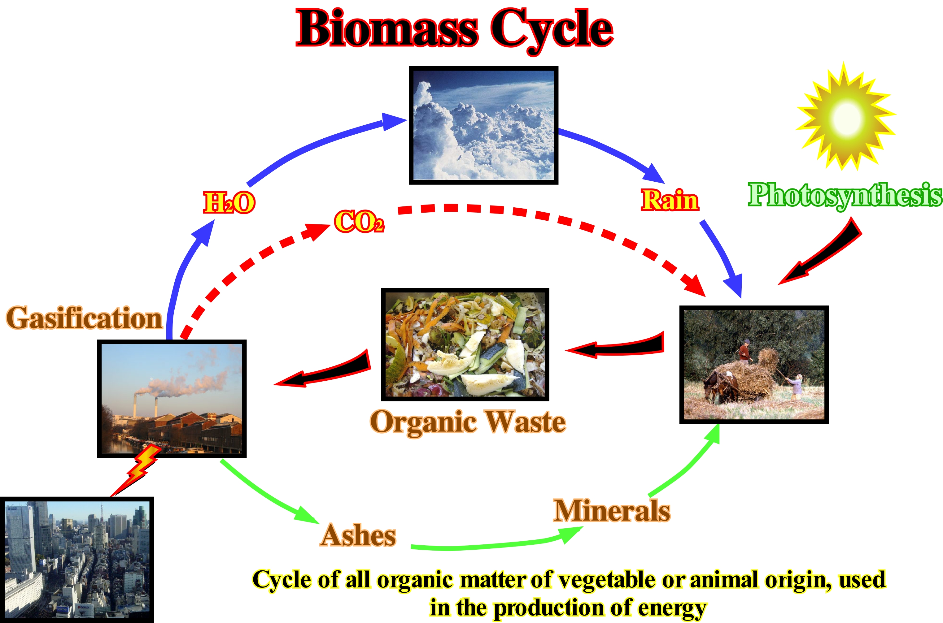
Biomass is a renewable energy source* that is dangerous to the environment if it is not used, since garbage produced by industrialized countries accounts for a large part of the Earth's pollution. Overall, the biomass energy capacity is about eight times (8 times) the annual energy consumption of mankind in all its forms. This, means, clearly, biomass is an important source of energy. At present, however, the world's population uses only about 7% of the annual biomass production, which means that we are using very little of an abundant energy source. Biomass can be burned as a fuel, but it can also be used to: (i) Condition and Fertilize soils ; (ii) Produce methane by anaerobic digestion and (iii) Produce ethyl alcohol by fermentation and distillation. Thus, burning biomass is not the only way to release your energy. Biomass can be converted into other forms of usable energy, such as methane or liquid fuels such as ethanol or bio-diesel**. By more complicated processes the biomass may be gassed, i.e., partially oxidized at high temperatures and converted to carbon monoxide (CO) and hydrogen (H), which may be used as fuel or transformed into petroleum. Basically, there are three types of gasification: (i) Pyrolysis, (C6H10O5 = 5CO + 5H2 + C) ; (ii) Partial Oxidation (C6H10O5 + O2 = 5CO2 + CO2 + H2) and (iii) Vaporization (C6H10O5+ H2O = 6CO + 6H2). The amount of gas energy produced from biomass gasification varies on average from 4 to 11 megajoules per cubic meter (4-11 MJ/m3).
(*) Energy from natural resources such as sun, wind, rain, tides, geothermal energy, biomass, etc., which are naturally renewable, which is not the case for oil, gas, coal, uranium and natural resources exist in limited quantity. Attention to the expression "renewable energy". Energy cannot be produced. It can just be transformed. What is renewable are the transformation processes not the energy.
(**) Bio-diesel, which can be mixed with traditional or pure diesel fuel, is synthesized from oilseeds (rapeseed, palm oil, soy-bean, sunflower, seaweed, animal fats, used vegetable oils, etc.). Production from these vegetable oils is carried out at 64 ° C by a chemical process and with the addition of 10% methanol.
Biopelite.............................................................................................................................................................................................................................................Biopelite
Biopelito / Biopelita / Biopelite (Schwarzer Schiefer) / Biopelite (黑色页岩) / Биопелит (органический пелит) / Biopelite /
A clayey rock (compact clay), finely, laminated and rich in sulphides, such as pyrite or organic material deposited under anaerobic conditions (in more or less isolated basins). Synonym of black shale (black clay for many geoscientists, although the term clay designates a sedimentary particle and not a rock) or ampelites (from the Latin ampelide) that certains geoscientists define as "oil shale"*
See: « Shale »
&
« Ingressão Marinha »
&
« Black Shale »
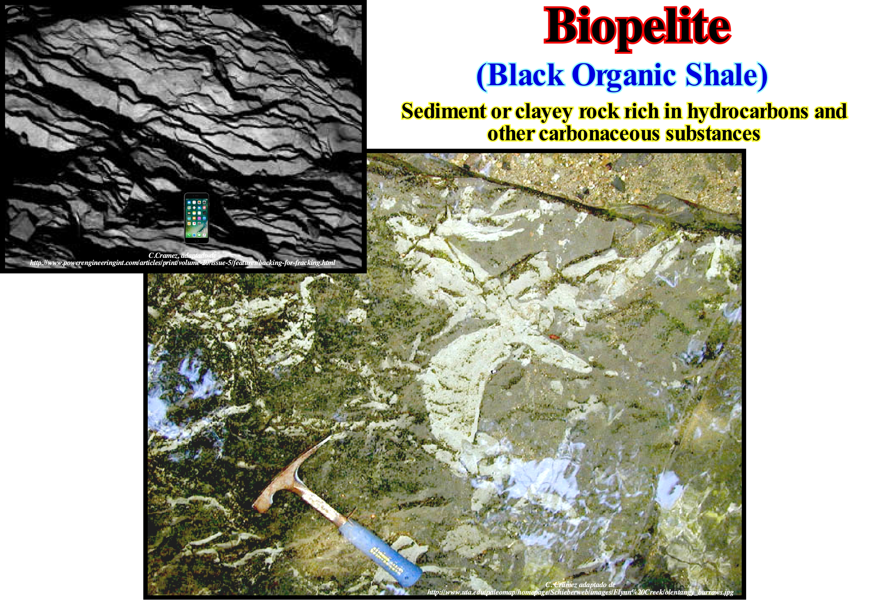
According to certain dictionaries a bio-pelite* is a, finely, laminated clay, which some geoscientists prefer to call shale (non metamorphic fissile clayey rock), dark, carbonaceous, exceptionally rich in organic matter (5% or more of carbon content) and sulphides (especially iron sulphide, in general, pyrite), as well as with an unusual concentration of certain trace elements (such as, U, V, Cu, Ni). In general, as illustrated in this figure, bio-pelites contain fossils (mainly planktonic forms), which are, usually, preserved by a graphite or carbon film or by replacement pyrite. The process of forming a bio-pelite is, mainly, compaction (the sediments are compressed by the action of the overlying sediments, the spaces between the grains, i.e., the porosity is reduced at the same time that a large part of the water is expelled). In fact, once the sand grains have settled down, the fine, less dense particles that make up the bio-pelites are suspended for a long time in the water. This means that the clay deposits settle down in very slow water flows, with little transport capacity. They are, often, found in lagoon deposits, river deltas, flood plains, and in certain beach deposits. Bio-pelites** can also be deposited on the continental shelf (in relatively deep, calm waters), as well as, in the deep parts of the sedimentary basin. Within a sequence-cycle, these conditions are frequent during the transgressive interval (TI), since the marine ingressions are in acceleration (relative sea level rises or eustatic paracycles without relative sea level falls between them), the shoreline is, successively, displaced continentward. However, during stability periods of the relative sea level, which occur between eustatic paracycles, regressive intervals increasingly smaller are deposits (sedimentary regressions). The marine ingressions increase, significantly, the extension of the continental shelf and create geological conditions of the starved basin (low deposition rate), in the distal parts, where bio-pelites, finely-laminated and rich organic, deposit. Bio-pelites, thus deposited, have, naturally, a dark colour. The carbon of the organic matter is not oxidized, since the sedimentary environment is, relatively, anoxic (poor in oxygen). When an upwelling marine current (cold and rich in oxygen and nutrients) is present, in the distal part of the continental shelf (usually during the transgressive interval of a sequence-cycle) an important flora and fauna producing organic matter develops. Due to a strong biological activity, which consumes more oxygen than what is formed as a residue of photosynthesis, near the sea-floor, an oxygen-depleted zone develops, allowing the preservation of organic matter. The formation and preservation of organic matter are typical conditions sina qua non of sedimentary environments where potential source-rocks can be deposited, i.e., rocks that can generate hydrocarbons. Hydrocarbon-generating bio-pelites may be mentioned : (i) Kimmeridgian black shales with an organic carbon content of up to 8%, in which dinoflagellates, spores, pollens and tasmanaceae (Tasmanite algae of the class Prasinophyceae) are abundant and whose radioactivity is mainly due to uranium ; (ii) The Lower Cretaceous black shales of the West African margin has a dark brown colour with interbedded of foraminifera rich sparitic limestone, containing 2 to 10% organic carbon ; (iii) The Upper Permian "schisty marls" of the North Sea, which are, actually, dolomitic laminated shales, sometimes, sandy and ferroginous, as well as (iv) The Silurian radioactive shales of the Sahara and Libya, not to mention the organic shales of the Vaca Muerta Formation (Argentina), Maykop, etc., etc.
(*) Oil shale is an organic-rich fin -grained sedimentary rock containing kerogen (a solid mixture of organic chemical compounds) from which liquid hydrocarbons, called shale oil (not to be confused with tight oil- crude oil occurring naturally in shales), can be produced. https://en.wikipedia.org/wiki/Oil_shale
(**) Many geoscientists divide clastic sedimentary rocks between three large groups: (i) Conglomerates or Rudites (Psephites) ; (ii) Sandstones or Arenites (Psammites) and (iii) Pelites (Lutites). The conglomerates (psephites) are made up of fragments of different size common rocks that in the Wentworth scale are greater than 2 mm in diameter. The sandstones are the rocks whose constituents have a size between 2 and 0.062 mm in diameter (according to the Wentworth scale). The pelites (lutites), which certain geoscientists call ooze, include all rocks constituted by sediments smaller than 0.062 mm in diameter. Within the pelites (lutites), siltites can be differentiated, in which the grain sizes vary between 0.062 and 0.004 mm in diameter and the shales, whose particles have a diameter smaller than 0.004 mm. The siltites have very heterogeneous composition, with the predominance of quartz on fine rock residues, clays and other minerals of variable nature. Shales may contain a high percentage of clays of different origin. In the classification of Petttijohn, the terms of Greek root (Psephite, Psammite and Pelite) are applied mainly to the anchi-metamorphic and metamorphic rocks, whereas the terms of Latin root (Rudite, Arenite, Lutite) are mainly used for the non-metamorphic rocks.
Biostasy...............................................................................................................................................................................................................................................Biostasie
Biostasia / Biostasia / Biostasie / Biostasy (气候条件) / Биостазия / Biostasia /
Maximum development of organisms when, during a period of tectonic inactivity, residual soils are formed, extensively, on the surface of the Earth and calcium carbonate deposited, significantly, on the seafloor.
See: " Depositional System "
&
" Carbonate Compensation Depth
"
&
" Soil "
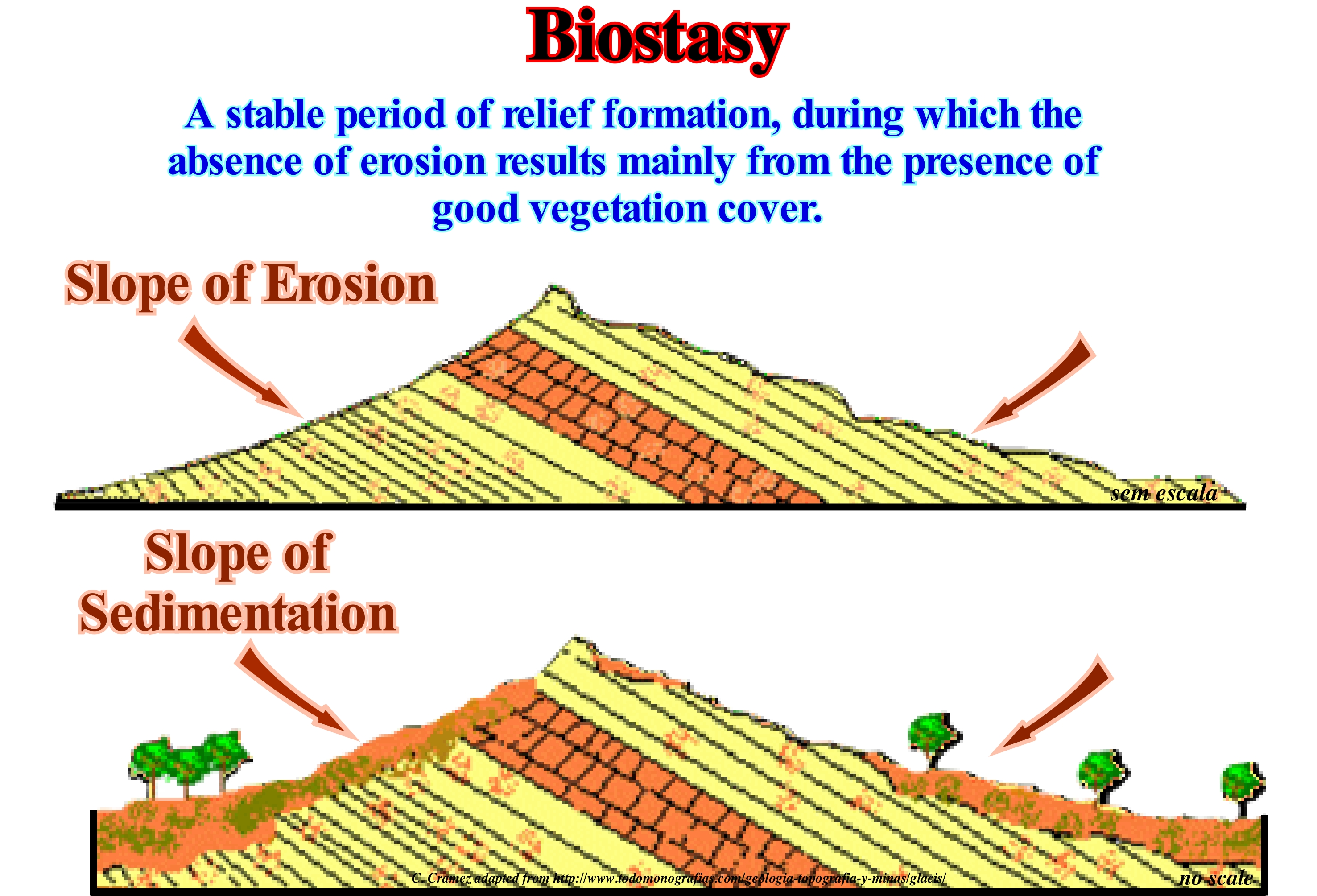
The role of climate* in the deterioration of rocks and soil formation led to the formulation of the biorhexistasy theory. This theory, which was proposed in 1951 by H. Erhart, describes the conditions necessary for alternating periods of soil formation (pedology) and periods of erosion. This theory defines two climatic phases: (i) Biostasy and (ii) Rhexistasy. In dry climates, rocks exposed to erosive agents are subject, above all, to mechanical disintegration, which produces coarse detrital material. The process or set of processes that originate this type of debris is known as rhexistasy. In humid climates, conditions are more favourable to the deterioration of rocks (mainly by chemical processes), vegetation development and soil formation. This period, very favourable to the development of life is called biostasy. During the biostasy periods, abundant and regular precipitation induces a strong pedogenesis due to chemical alteration of the original materials and intense eluviation, as well as an illuviation** of soil minerals not only on the surface, but also on the deeper layers of the subsoil. These processes contribute to the formation of eluvial and shaly horizons and increase the concentration of iron oxides, aluminium oxides and other sesquioxides in the subsoil. The favourable climatic conditions that protect the soil from physical erosion, with abundant rainfall, result in the loss of mineral ions and an increase in the concentration of these minerals in the water-bodies where the streams flow. In marine environments, a sufficient amount of calcium, naturally, induces the formation of limestones. During the rhexistasy, the protective vegetative cover is reduced or eliminated as a consequence of the dry climate. However, the intensity of the rains is greater. A dry climate delays pedogenesis. Soils do not contribute to the formation of limestones (biostasy). Unprotected soil and wind, which expose the soil, favour erosion. The glacial conditions increase the particle size of the debris.
(*) Climate refers to the long-term physical state of the atmosphere, in particular its temperature, with a special interest in the water it contains in the form of vapour, liquid (clouds, fog, rainfall) and solid (hail, snow) and a focus on the lower part of the atmosphere (troposphere). It is the periods considered that differentiate meteorology, weather science (weak periods of time) and the science of climate or climatology (long periods of time).
(**) Accumulation of soil materials dissolved or suspended in an area or horizon as a result of eluviation, i.e., as a result of material displacement (clays, sesquioxides, carbonates, etc.) along a soil profile, from one layer to another, by the action of rainwater.
Biostratigraphic Unit................................................................................................................................Unité Biostratigraphique
Unidade biostratigráfica / Unidad biostratigráfica / Biostratigraphische Einheit / 生物地层单位 / Биостратиграфическая единица / Unità biostratigrafica /
Set of strata characterized by their fossils, which were deposited at the same time or by their paleontological characteristics, which differentiate them from the adjacent strata. A biostratigraphic unit may have a chronostratigraphic or environmental meaning.
See: « Stratigraphy »
&
« Chronostratigraphic Unit »
&
« Lihtostratigraphic Unit »
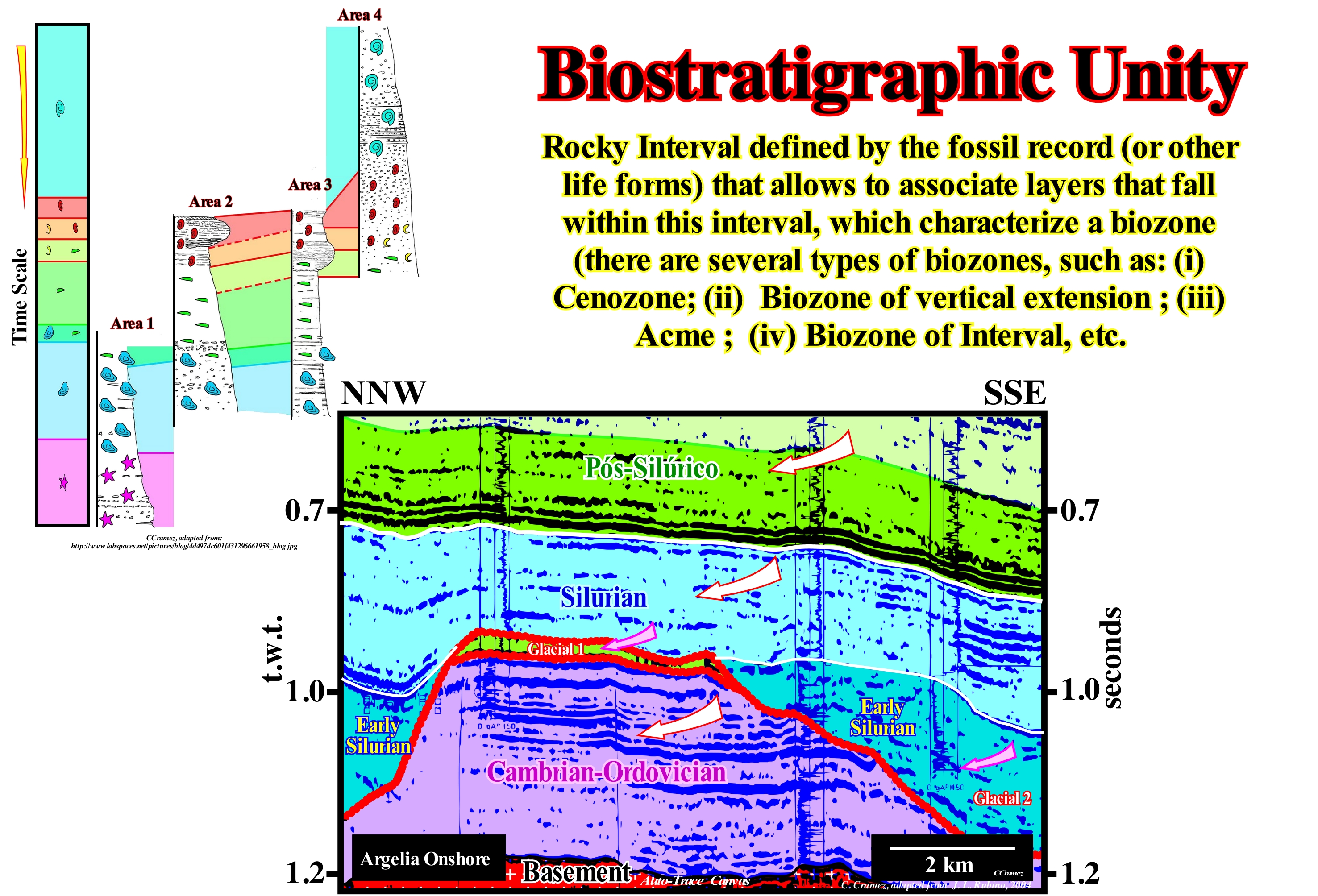
The strata can be subdivided according to their physical characteristics, independently of the fossils they contain and their spatial relations. Three major types of stratigraphic units can be considered: (i) Lithographic Units; (ii) Biostratigraphic Units and (iii) Chronostratigraphic Units. A lithostratigraphic unit can be formed by sedimentary rocks, igneous, metamorphic and in some cases by an alternation of these types of rocks, which means that a lithostratigraphic unit corresponds to a three dimension rocky body, since the concept of lithostratigraphic unit is applied vertically and laterally. A chronostratigraphic unit measures the geological time, whose scale is based on the time-series of the main geological events that have occurred on Earth since its formation about 4.6 Ga. The main chronostratigraphic units are Era, Period, Epoch and Age, which correspond, respectively, to the chronostratigraphic units, Group or Erathem, System, Series, and Stage or Sub-stage. The biostratigraphic units, as illustrated on this tentative interpretation of a Canvas auto-trace of a detail of an onshore seismic line from Algeria, and as defined above, are sets of rocks or strata unified by their fossils or paleontological characteristics, which differentiate them from rocks or adjacent strata. A biostratigraphic unit can be defined: (a) Simply by the presence of fossils ; (b) By the type of fossils it contains or, just, by the fossils of a certain type ; (c) By a taxon, which is a taxonomic unit, essentially, associated with a scientific classification system, which may indicate a unit at any level: (i) Kingdom (superior category of the scientific classification of organisms introduced by Linus in XVIII century, (ii) Genus (a grouping of living organisms/fossils that includes a set of species that share a very wide set of morphological and functional characteristics, a genome with a high degree of community and a very great phylogenetic proximity, reflected by the existence of common ancestors next) and (iii) Species (a group of organisms similar to each other, able to cross and generate fertile offspring) are taxa, just like any other unit of a classification system of living beings ; (d) By a particular association of fossils ; (e) By the distribution of taxon or fossil taxa ; (f) The abundance of certain species of fossils ; (g) By the morphological characteristics of the fossils ; (h) By the way of life and habitat of fossilized organisms ; (i) The stages of evolutionary development of fossils ; (j) By the variations of other factors related to the fossils that the strata contains, etc. On this tentative geological interpretation of a Canvas auto-trace of a detail of an onshore seismic line from Algeria, the Cambrian/Ordovician, Silurian and post-Silurian intervals correspond to biostratigraphic units, since they were characterized mainly by fossils recovered during drilling wells. The basement and glacial intervals 1 and 2 are, mainly, lithostratigraphic units. They were individualized on the basis of a certain lithological type and, independently, of the fossils that they may contain. The unconformity that limits the basement corresponds to a surface of erosion, which in this particular case was induced by a significant fall of the absolute or eustatic sea level associated with breakup of the supercontinent Proto-Pangea, whereas the unconformity underlined in red and that limits, superiorly, the Cambrian/Ordovician interval Is associated with a significant fall of the relative sea level (local sea level, referenced at any point on the Earth's surface and which is the result of the combined action of absolute or eustatic sea level and tectonics), which put the sea level lower than the basin edge, which is the last continental edge of the preceding sequence-cycle. This fall in relative sea level was, chiefly, induced by the glacio-eustasy associated with the great Ordovician glaciation. The vast valleys visible on this auto-trace, each side of the Cambrian / Ordovician paleohigh are glacial valleys, which were filled in the Early Silurian, during the deposition of lowstand prograding wedges (LPW), before the sea level flooded the coastal plain. This means that before the pre-existing topography (Ordovician) was covered by the sea, the glacial valleys were flooded creating restricted sedimentary environments appropriate to the development of potential source-rocks.
Biostratigraphic Zone..............................................................................................................................Zone Biostratigraphique
Zona biostratigráfica / Zona biostratigráfica / Biostratigraphische Zone / 生物地层区 / Батипелагическая зона / Zona biostratigrafiche /
Set of strata that are defined on the basis of the characteristics of a fossil taxa. Synonym of zone (stratigraphic). The time (geological) represented by a biostratigraphic zone is the biochron.
See: « Biostratigraphy »
&
« Relative Age »
&
« Lithostratigraphy »
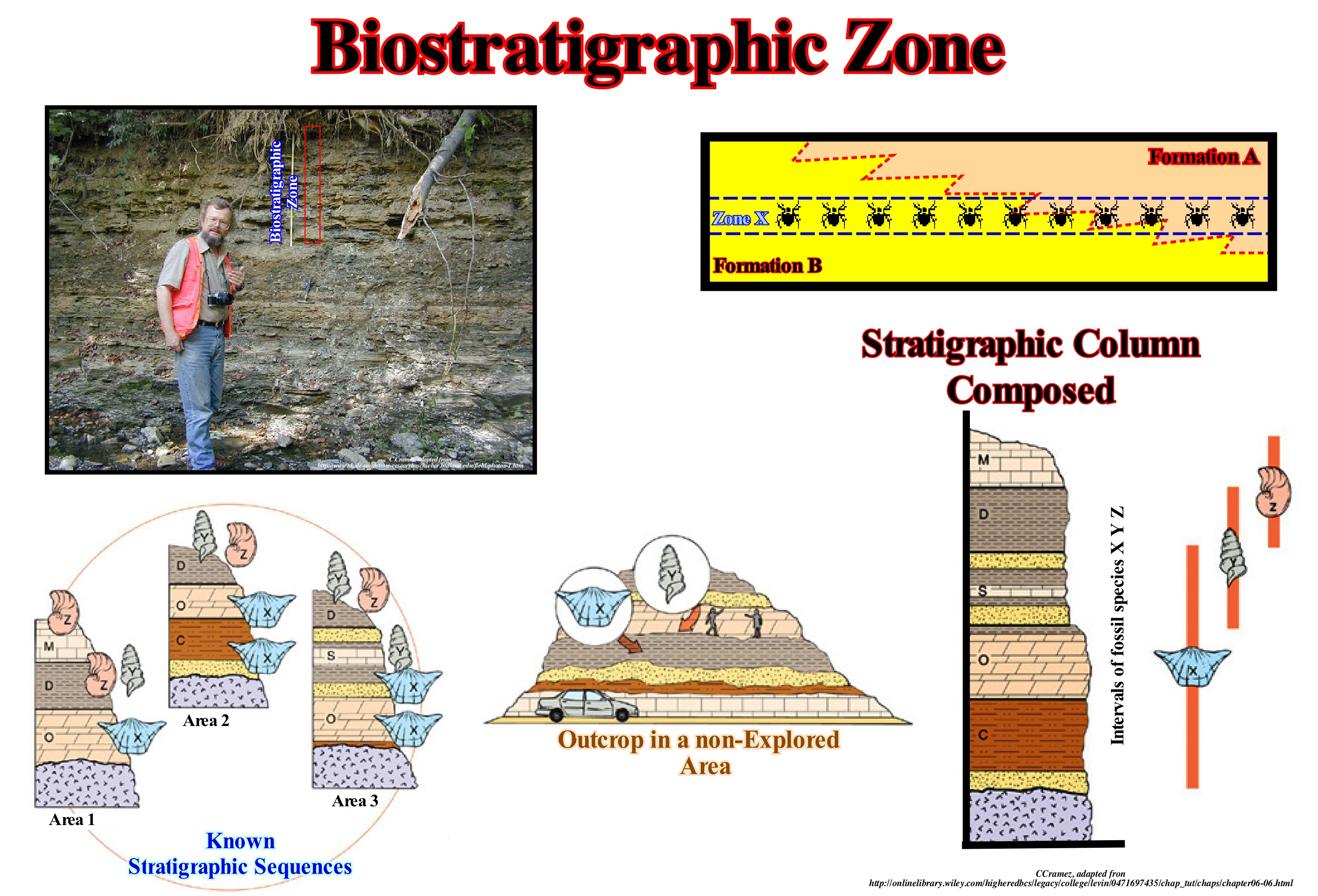
A stratigraphic zone or biozone or simply zone is a general term, which geoscientists use to designate any type of biostratigraphic unit. As there are many ways to sub-divide the strata into biostratigraphic zones or biozones, some geoscientists distinguish different classes of biozones: (i) Assemblage Biozone, which is a stratigraphic interval, distinguished by having a natural set characteristic of all fossil forms present or of certain types or types of forms present (the set zones are environmental indices but also indicate age, although they are not defined on the basis of the total extent of the rate) ; (ii) Biozone of Extension (both vertical and horizontal), which is the grouping of strata, representing the stratigraphic extension of a certain element of the total set of fossil forms present; there are several types of extension zone (taxon extension zone, coincident extension zone, lineage zone or phylogenetic zone) ; (iii) Apogee Biozone (acme), which is a set of strata based on the abundance or development of certain forms, whatever their association or extension ; apogee or acme zones, also called culmination or flood zones, are valuable indexes of the stratigraphic position ; (iv) Interval Biozone, which is the stratigraphic interval between distinct biohorizons ; the interval zone is neither an extension zone of a given taxon (an entity that regroups all living organisms that have certain well-defined characteristics in common), nor coincidence of several taxa, nor have distinct fossil associations or peculiar biostratigraphic features. The denomination of the interval biozone uses the biohorizons that limit it starting at the lower horizon, such as, for example, the biozone of interval Globigerinoides sicanis/Orbukina sutuiralis (Hedberg, H.D., 1980). Function of the circumstances, other types of biozones, such as those based on the ichnofossils (tracks), re-deposited fossils, morphological changes of certain communities, etc., can be considered. Set of layers containing specific types of fossils both horizontally and vertically are biostratigraphic units. Cenozones are set of layers in which the fossiliferous content, constitutes a natural set, distinguishing them from the adjacent layers. This biostratigraphic unit is useful for use as an indicator of the environment and for the establishment of correlations. They do not present great temporal meaning and their limits are defined in the extremes of occurrence of characteristic set. Acrozones are biostratigraphic sub-divisions used to refer to the zone of duration of a taxon. In this figure, the famous biozone Foerstia (pelagic algae of the late Devonian) is illustrated in the clay of Chagrin (Columbus, Ohio State, USA). It should be remembered that the strata can be sub-divided according to the physical characteristics, the fossils they contain and the spatial relationships between them, and that three types of stratigraphic units are generally considered: (i) Lithographic Units; (ii) Biostratigraphic Units and (iii) Chronostratigraphic Units. A lithostratigraphic unit can be formed by sedimentary rocks, igneous, metamorphic and in some cases by an alternation of these types of rocks, which means that a lithostratigraphic unit corresponds to a rocky body to three dimensions, since the concept of lithostratigraphic unit is applied vertically and laterally. There is no specific geographical extension for lithostratigraphic units, which always depends on the continuity and extension of the characteristics that are verified. A biostratigraphic unit is a set of rocks or strata unified by their fossils or paleontological characteristics, which differentiate them from adjacent rocks or strata, which can be defined: (a) By the presence of fossils ; (b) By the type of fossils it contains or, just, by the fossils of a certain type ; (c) A taxon, which is a taxonomic unit, essentially associated with a scientific classification system, which may indicate a unit at any level ; (d) By a particular association of fossils ; (e) By the distribution of taxon or fossil taxa ; (f) The abundance of certain species of fossils ; (g) By the morphological characteristics of the fossils ; (h) By the way of life and habitat of fossilized organisms ; (i) The stages of evolutionary development of fossils ; (j) By the variations of other factors related to the fossils that the strata contains, etc. A chronostratigraphic unit measures geological time, whose scale is based on the ordering, in time, of the main geological events that have occurred on Earth since its formation about 4.6 Ga. The main chronostratigraphic units are Era, Period, Epoch and Age, which respectively correspond to chronostratigraphic units, Group or Erathem, System, Series, and Stage or Sub-stage.
Biostratigraphy......................................................................................................................................................................................Biostratigraphy
Biostratigrafia / Bioestratigrafía / Biostratigraphie / 生物地层学 / Биостратиграфия / Biostratigrafia /
Science of dating rocks using the fossils they contain. The purpose of biostratigraphy is the correlation*. Sediments of the same age may have completely different lithologies due to lateral variations of the sedimentary environment. If two stratigraphic sections, formed by shaly rocks, marls and limestones have the same fossils, the two sedimentary intervals are considered to be synchronous, which means that they were, probably, deposited at the same time, but in different environments.
See: « Stratigraphy »
&
« Index Fossil »
&
« Sedimentary Environment »
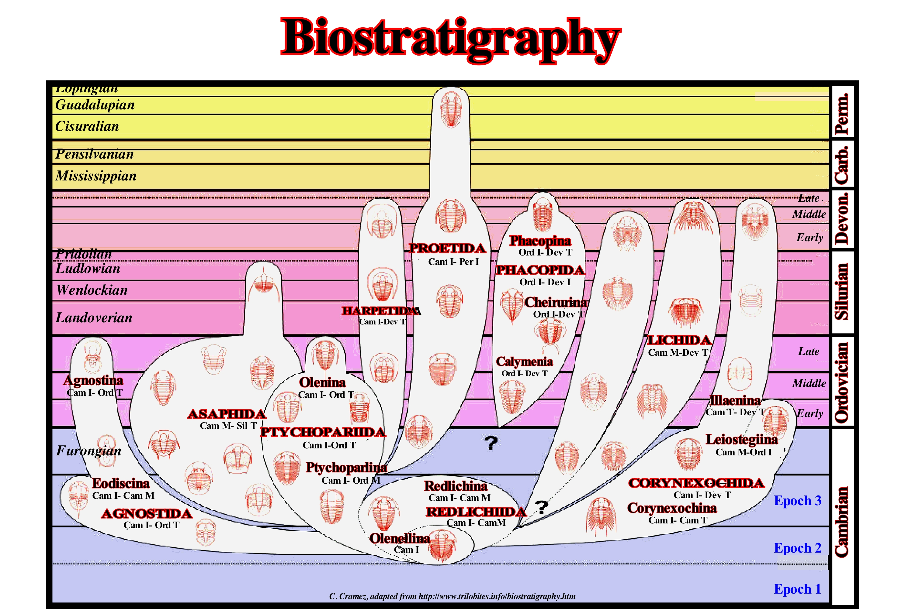
Biostratigraphy is a sub-discipline of stratigraphy in which the evolution of living organisms can be considered an irreversible marker of time. That is why fossils are used in geological layers to define time units (biozones) as short as possible. Biostratigraphy contrasts with biochronology that attempts to correlate, in time, biological events from fossils (remains or traces of animals or plants that existed in past geological times and were preserved or imprinted on rocks) and which corresponds to a geological time according to the irreversible process of continuous organic evolution. Biostratigraphy is iterative, since it is based on the observation of successions of overlapping fossils without their own chronological significance. An inverted biology or with many gaps through no deposition is, perfectly, useful as long as it is consistent. In reality, it is the arrangement and temporal correlation of the biostratigraphies that make up the often devalued role of biochronology. Let us remember (https://en.wikipedia.org /wiki/Biochronology) that biochronology is the time correlation of biological events from fossils from the use of fossil clusters that are not linked to stratigraphic sections (in contrast to the biostratigraphy, where they are). Collections of terrestrial mammal ages have been defined for all continents, except for Antarctica, and most are interrelated, indirectly, through known evolutionary lineages. A combination of argon/argon dating and magnetic stratigraphy allows for a direct temporal comparison of terrestrial events with climatic changes and mass extinctions. Although the dinosaurs (a group of several animals belonging to the clade Dinosauria, originated from a single common ancestor) are perhaps the most well-known fossil forms, the trilobites (extinct class of primitive arthropods), which existed at about 300 Ma, in all continents. Trilobites, which are characterized by a hard carapace that protects the body, formed by several segments and with articulated feet, are probably the favourite fossils of paleontologists. In biostratigraphy, as shown in this figure, trilobites (a class composed of ten orders, about 150 families, more or less 5000 genera and more than 20,000 species described) are the fossils most used to determine the order and relative age of the strata of the Paleozoic Era (era of the Phanerozoic eon comprised approximately between 542 Ma and 245 Ma). The trilobites covered almost all of the Paleozoic Era, with very varied forms in the stratigraphic records and occupied, practically, all continents (new species of trilobites are discovered every year by paleontologists). Certain species occupied distinct areas and within very restricted stratigraphic limits, what makes them characteristic fossils or guides, that is, those that serve to characterize a certain era of the geological history. In addition to the trilobites, other fossil groups are used in the Paleozoic biostratigraphy: (i) Graptolites, which are colonies of marine invertebrates with a distinct skeleton ; (ii) Foraminifera, which are tiny unicellular eukaryotes protected by a shell ; (iii) Conodonts, which are elements of the hard parts of the mouth of primitive marine vertebrates; (iv) Archaeocyathids (ancient cups) that were a phylum of extinct, solitary or colonial organisms, with internal skeletons of calcareous nature, whose fossils are mainly found in carbonate facies of the Early Cambrian and whose existence lasted only until the Middle Cambrian), etc. The biozone is the fundamental biostratigraphic unit. It is defined by the biological content of the sediments. The biozones are characterized by the appearance and disappearance of taxa (plural of taxon). Thus, it is possible to distinguish: (i) Assemblage Biozones or Cenozones; (ii) Distribution or Existence Biozones (acrozones), which may be of concomitant, consecutive (lineage zone) and Oppel** distribution ; (iii) Abundance Biozones or Apogee Biozones and (iv) Interval Biozones. An assemblage biozone is a set of layers in which its fossil content or certain types of fossils, in their entirety, constitute a distinct set of adjacent layers. A distribution biozone is the set of layers that represents the total extent of a given fossil. A biozone of abundance is the set of layers characterized by the maximum abundance of a given taxon. An interval biozone is the set of layers located in the different rate range.
(*) Corroboration that a horizon of a geological section has been deposited at the same time as another horizon of the same section.
(**) The name of the Oppel interval biozone, named after the German geoscientist Albert Oppel (1831-1865), is a biozone in which the taxa are selected to be a good geochronological criterion. The boundary of this zone coincides with that of the next, so that there is a geological time division.
Biostrome.................................................................................................................................................................................................................................Biostrome
Biostroma / Biostroma / Biostrom / 生物层 / Биостром / Biostrome /
Horizontal accumulation of skeletal remains. The terms biostrome and bioherm were used by Cumings (1932). Bioherm has become, lprogressively, synonymous of reef due to its discreet mounded or lenticular geometry in vertical section. The phrase "reefs and biostromes" is very common in the literature. It underlines the fact that biostromes, unlike bioherms, are not, normally, regarded as reef structures due to the absence of topographical relief and structure.
See: « Fossil »
&
« Bioherm »
&
« Reef »
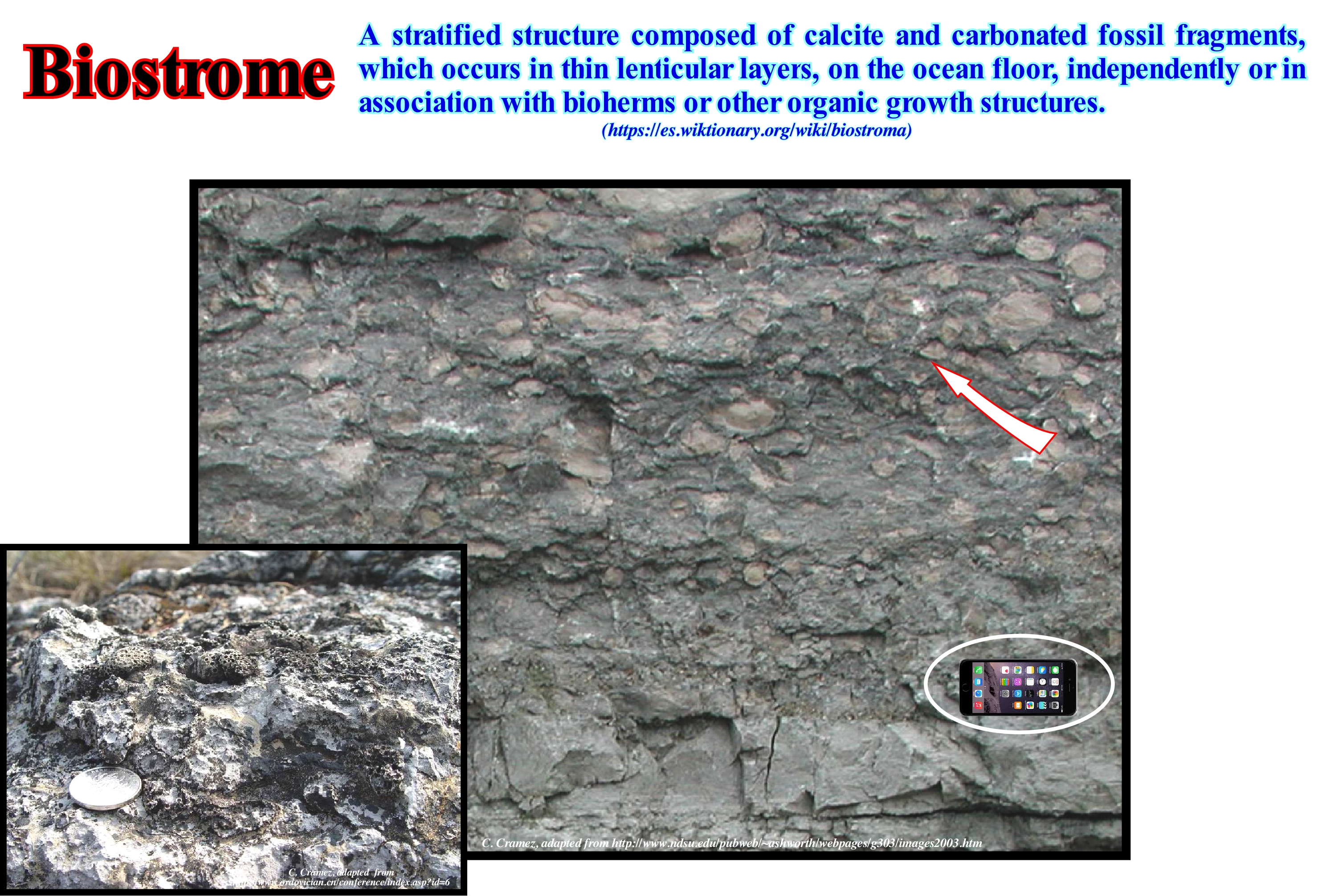
This figure illustrates two biostromes. The lower outcrops near Zhuzhai (NE province of Jiangxi, China) and the upper one in Iowa (USA). As can be seen, a biostrome is a stratified structure or stratigraphic level (bioclastic stratum) composed of calcite and calcoarenitic fossil fragments, which are here, more or less dolomitized, deposited on the sea-bed independently, or in association with bioherms or other organic growth structures. When talking about organic growth, in situ, one must take into account that most times it is a simple hypothesis of work, which has to be tested, that is to say, criticized. Crinoid limestones (commonly known as sea lilies), for example, result, obviously, of the accumulation of millions of decomposed pieces of pedunculated echinoderms*, which are often accompanied by debris of briozaria (animals living in colonies with a skeleton of calcium carbonate and superficially similar to corals). Normally, however, it is almost impossible to determine whether the debris has fallen vertically (centimeters or meters) through the water column, as dead organisms (essentially as in situ deposits), or if they have been stacked mechanically by the currents of the sea. The same can be said for the coquinas** of many other conchiferous levels, such as those of the briozarias, brachiopods and trilobites. Not all biostromes are deposited horizontally. Biostromes with slopes of 25°-30° are not rare, in particular, on the flanks of organic constructs. In fact, these biostromes, which cover fixed organisms living just above the deposition domain, deposit as sedimentary avalanches on the flanks of organic constructs.
(*) Marine invertebrate animals with no head which have a radial symmetry and the body divided into 5 similar sectors. They have a hydrovascular system formed by an internal network of channels and reservoirs where an aqueous fluid under pressure flows, filtered from the water of the which enters through a special opening (mother board). Echinoderms have a fragile epidermis that covers an endoskeleton consisting of several calcareous plaques attached by muscles and a special tissue whose consistency can vary rapidly, allowing them to move, defend themselves or simply divide them into two. Echinoderms that have existed since the Paleozoic (there are more than 500 Ma) are found between the equator and the poles (from the abyssal zone to the intra-tidal zone).
(**) Carbonated sedimentary rock, formed by shells or shells of marine organisms.
Biota (Taxonomy)........................................................................................................................................................................................................................................Biota
Biota / Biota / Biota / 生物群 / Биота (флора и фауна определённого района) / Biota /
Set of fauna and flora of a region at a particular moment in geological history. The total set of organisms of a certain area at a given time. The Earth's biota lives in the biosphere, i.e., the part of the Earth that includes air, earth and water, in which life develops, changes and transforms by biotic processes (influence of organisms).
See: « Fossil »
&
« Biostratigraphy »
&
« Facies »
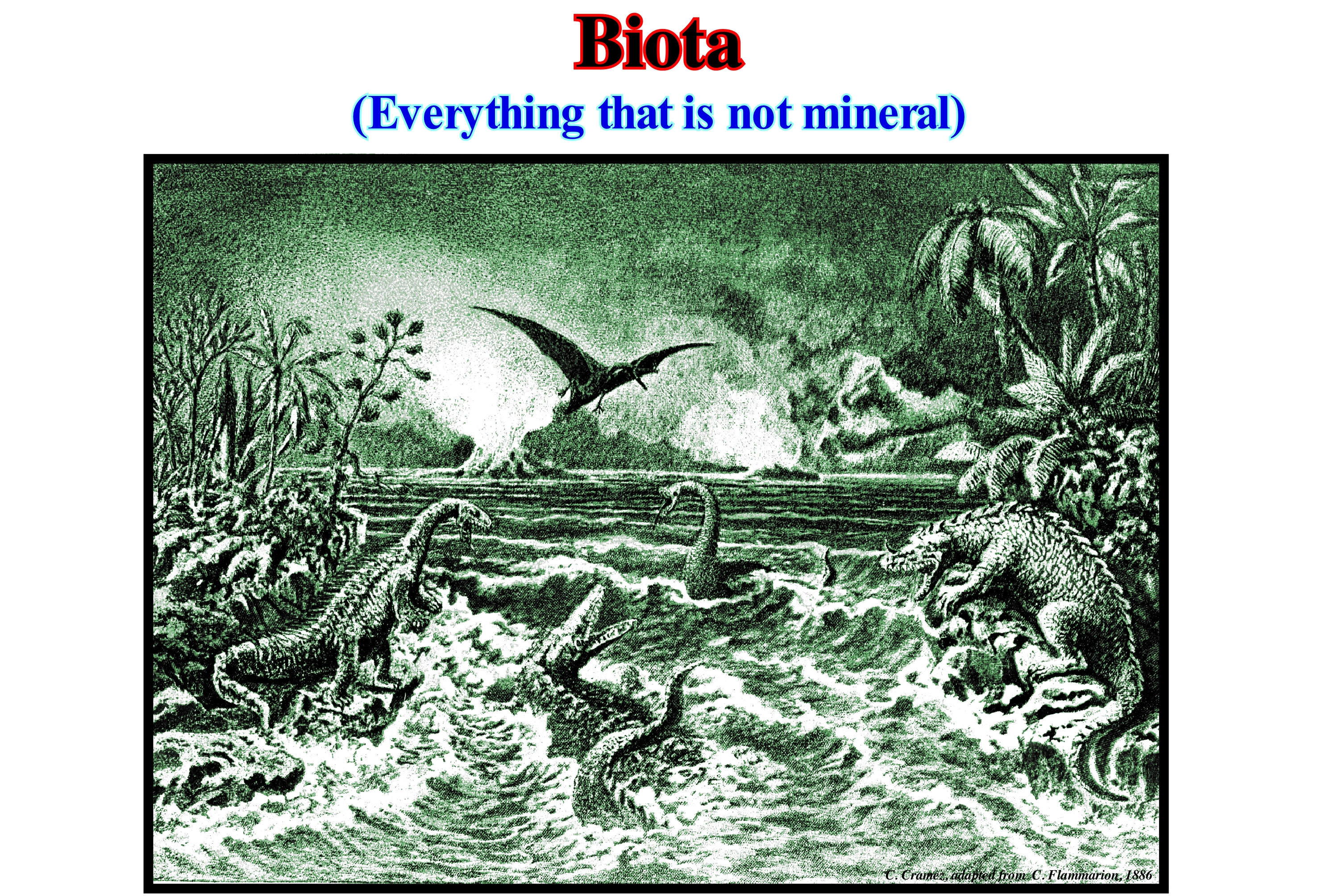
Biota is the set of living things in an ecosystem, which includes flora, fauna, fungi and other groups of organisms. A part of the Mesozoic-era biota, which is divided into three periods: (i) Triassic (between 248.3 Ma and 205.7 Ma) ; (ii) Jurassic (between 205.7 Ma and 144,2 Ma) and (iii) Cretaceous (between 144.2 and 65 Ma), it can be deduced from this scene of the primitive world (secondary), proposed by Camille Flammarion, in 1886, in his book "Le Monde avant la Création de l'Homme". In the Mesozoic (term meaning middle or intermediate animals), the Earth's fauna changed, drastically,, in relation to what was known in the Paleozoic era. Dinosaurs (one of the most successful animal groups in terms of longevity, of various sizes, shapes and lifestyles), which are perhaps the most popular organisms of the Mesozoic, developed gradually, in the Triassic but just in the Jurassic is that they have reached a great diversity, as it is verified in this image. The dinosaurs died out at the end of the Cretaceous. It seems the last dinosaurs are those that were found in the deposits of the Upper Cretaceous of Montana (USA). Birds, though descendants of dinosaurs, developed particular specializations to adapt to flight: (i) A unique way of breathing ; (ii) Light and hollow bones ; (iii) Skeletal suture ; (iv) Strong muscles and (v) Feathers, etc. The Mesozoic was, also, a period of great change of terrestrial vegetation. At the beginning of the Mesozoic, the ferns, cycadales (spermatophyte plants, i.e., vascular seed-producing plants), ginkgo*, benetitines (predecessors of angiosperms, similar to cycadales, with hermaphrodite floral structures with differentiated anophiles) dominated and other plants uncommon. Modern gymnosperms, such as conifers, appeared in their most characteristic form at the beginning of the Triassic. In the middle of the Cretaceous, the first angiosperms (spermatophytes whose main characteristic is the production of flowers for reproduction) made their appearance and began to diversify and become the group of plants preponderant.
(*) Gymnosperms, i.e., vascular plants with seeds not protected by fruits, are classified into four classes: (i) Cicadaceae; (ii) Ginkgoines; (iii) Conifers and (iv) Gnetophytes.
(**) Modified leaves that constitute parts of a flower.
Biothem.............................................................................................................................................................................................................................................Biothème
Biotema / Biotema / Biotem / Biotema (生物地层单位) / Биотема / Biotema (unità biostratigrafiche) /
Practical unit with definition and degree of refinement, solely, dependent on the quality and availability of biostratigraphic controls. Biothems represent conceptual stratigraphic hierarchies. In a decreasing hierarchy, generally, three types of biothems are considered: (a) Synthems ; (b) Mesothems and (c) Cyclothems. Ideally, each biothem and, particularly, the mesothems and cyclothems are interpreted as being deposited in relation, and probably equivalent, to a cycle of sedimentary transgressions / regressions (retrogradation of the coastal deposits and then seaward progradation).
See: « Mesothem »
Biotic Province.............................................................................................................................................................................................Biotique (Province)
Biótica (província) / Biótica (provincia) / Biotische Provinz / 生物省 / Биотическая провинция / Provincia biotica /
Geographic area that supports one or more ecological associations distincts from adjacent provinces.
See: « Biostratigraphy »
&
« Theory of Evolution »
&
« Systems' Theory »
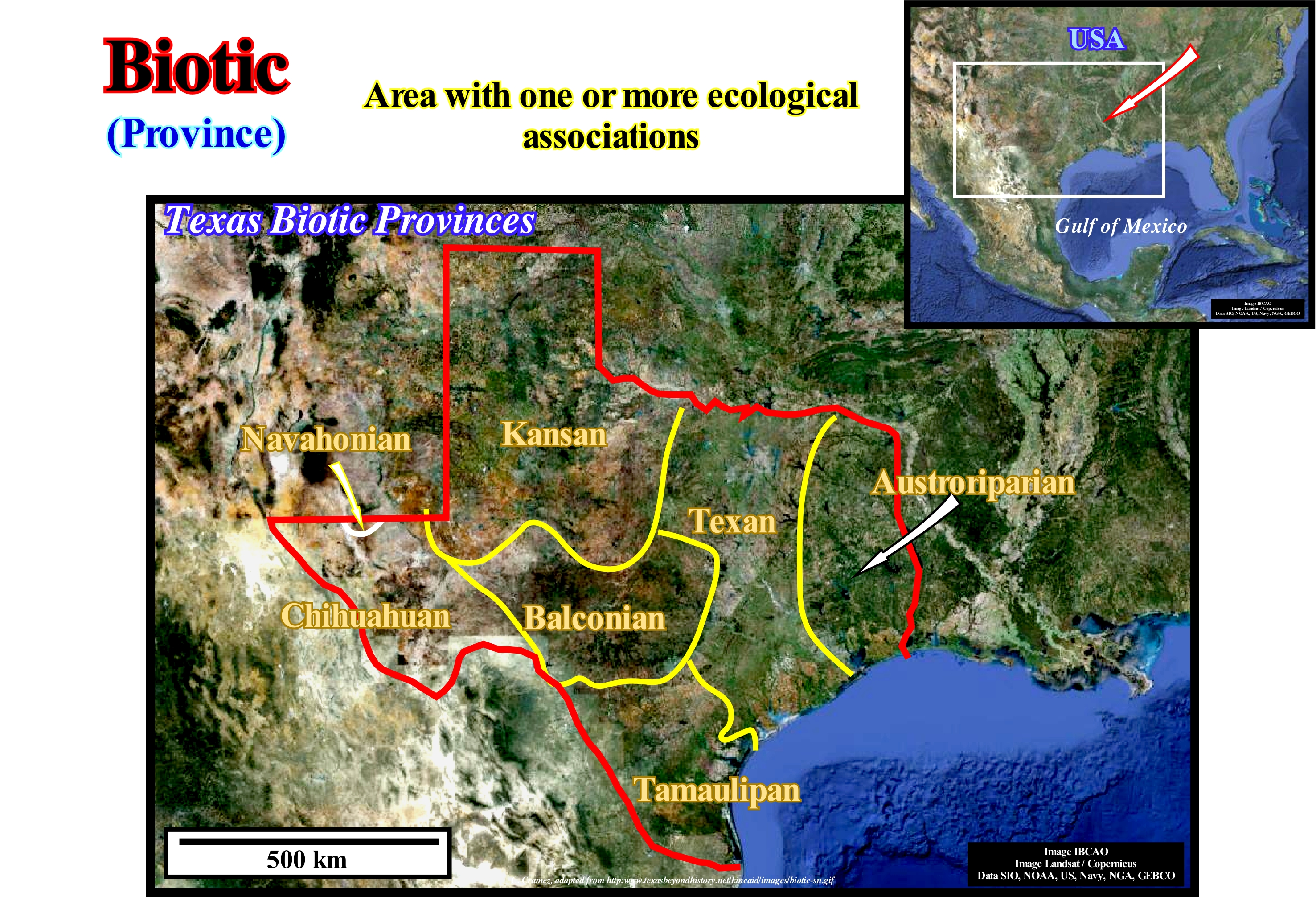
According to certain classification systems, a biotic province is a community, which occupies an area where the similarity of climate*, physiography and soils translates into the occurrence of similar combinations of organisms. Certain geoscientists have examined the usefulness of the concept of biotic province (proposed by Dice, 1943) as a tool for normalizing biogeographic studies. They argued that biotic provinces challenge standardization when attempts are made to delineate them on a statistical or empirical basis. In effect, they compare the boundaries of all species of amphibians and reptiles that occur within Mexico, with the boundaries of the province itself, and found important disagreements between the two. Therefore, they discouraged the use of the concept of biotic province as a normalizing index for biogeographical regions. They issued a warning to systematicians who describe a new taxon on the basis of its occurrence in a different locality, or that delimit the area of a little-known taxon, referring solely to the boundaries of the province in which it occurs. Recently, some geoscientists have tried to evaluate the value of the concept of biotic province in systematics. For them, the biotic provinces seem to be the main instrument of systemic zoology. Theoretically, biotic provinces help to: (i) Predict boundaries when available data are few ; (ii) Predict the differentiation of two or more similar population samples and (iii) Guess paleo-zoogeographic phenomena that may be obscured by ecological or spatial relationships. Above are illustrated the Texas biotic provinces, based on the distribution of plants and animal communities. Thus, the "Kincaid Shelter" (refuge cave on the limestone cliffs above the Sabinal River, where about 13,000 years ago a group of men protected themselves from the wind and rain as well as the great carnivores that travelled the area) were found in an ecotone (transition region between two biological communities), i.e., the transition zone between the semi-arid environment of the thorny shrubs of Tamaulipan province and the environment of the oak savannah of the Balconian province. This cartography of different environments with diverse features makes this area very attractive for hunters and collectors.
(*) The World Meteorological Organization defined climate, more or less, as follows: Climatology is the study of climate, its variations and its impact on various activities such as (not exhaustively) those affecting human health, safety and well-being. In a narrow sense, the climate can be defined as the time it does on average. In the broadest sense, it is the state of the climate system. The climate can be described in terms of a statistical description of the central tendency and variability of persistent elements such as temperature, precipitation, winds or through a combination of elements such as the time types characteristic of a place, region or for a given period of time (at least 30 years for many climatologists).
Bioturbated Trace........................................................................................................................................Empreinte de bioturbation
Marca de Bioturbação / Marca de bioturbación / Fußabdruck von Bioturbation / 足迹扰动 / Биотурбационное затопление / Tracia bioturbata, Impronta di bioturbazione /
Fossil trace of bioturbation preserved in poorly consolidated sediments or in the hardened substrates resulting from the activity of being alive. Bioturbation marks, known as ichnofossils, encompass traces and surface tracks, underground burrows and perforations, as well as, faecal matter and marks produced by the death of animals.
See: « Paleontology »
&
« Ichnofossil »
&
« Bioturbation »
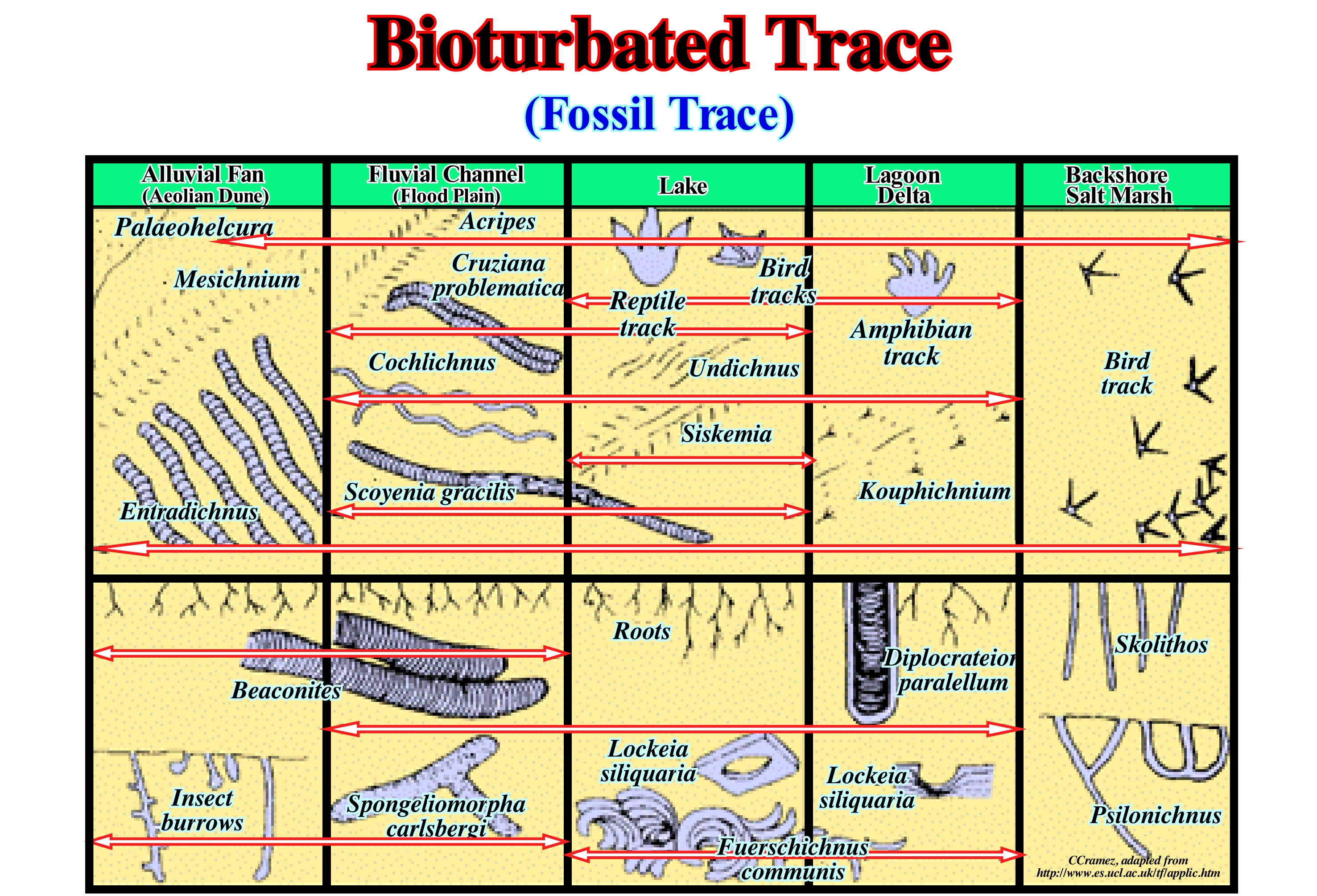
The earliest marks of bioturbation* fossils are simple trails and date from about 570 Ma. Before the Cambrian these traces are rare and very small (± 1 mm wide) and were, probably, formed by worms. Over time, however, fossil features, gradually, increased in complexity. Any animal, which lives in or on the sediments, digs holes and moves across the surface disturbing and deforming the sediments. Any kind of sediment disturbance is called bioturbation. However, this same term is used more, restrictively, to designate the rupture of sedimentary layers by excavating organisms. The sedimentary rocks of the Archaic and Proterozoic are characterized by an absence of textures induced by bioturbation. Fossil traces and bioturbation begin to appear on sedimentary rocks, from the end of the last great glaciation of the Proterozoic (Varanger/Marinoan ice age, between 600 and 590 Ma). The fossil or ichnofossil features underline the evidence of a bioturbation produced in soft sediments and hard substrates as a result of the life activities of organisms. They include traces and surface tracks, burrows and small underground wells, as well as, faecal material and marks produced by the death of animals. The factors that control the distribution of different types of fossil traits are environmental, not temporal, so most of the ichnofossils have a large stratigraphic distribution. In this figure there are illustrated Palaeophycus / Thalassinoides, which are flat and cylindrical burrows with a diameter ranging from 5-25 mm and which are, generally, rectilinear or branched in the shape of a Y. These marks of bioturbation, which can form very complex tangles, and are generally interpreted as traces of housing or crawling of crustaceans.
(*) Process of building sedimentary structures of biological origin (such as crab or earthworm holes, sandstone accumulations, paw marks, etc.) characteristics of specific environments, disturbing the sedimentary or pedogenic structure to which they overlap (http: // www. aprh.pt/rgci/glossario/bioturbacao.html).
Bioturbation.............................................................................................................................................................................................................Bioturbation
Bioturbação / Bioturbación / Bioturbation / 生物扰动 / Биотурбация / Bioturbazione /
Remobilization of sediments by organisms. The disturbance of the sedimentary layers by biological activity is, with the erosive action of the waves, the most important geological process on the sea-floor. Numerous animals, such as the annelids (body is divided into rings) live on the sea-floor, where they subsist by consuming the organic matter trapped between the sedimentary particles. Other animals, such as molluscs, pierce sediments to hide from predators that swim or crawl on the ocean floor. For various reasons, benthic animals, by bioturbation, destroy pre-existing sedimentary structures such as crossing stratification, ripples, etc.
See: « Sediment »
« Diagenesis »
&
« Shoreface »
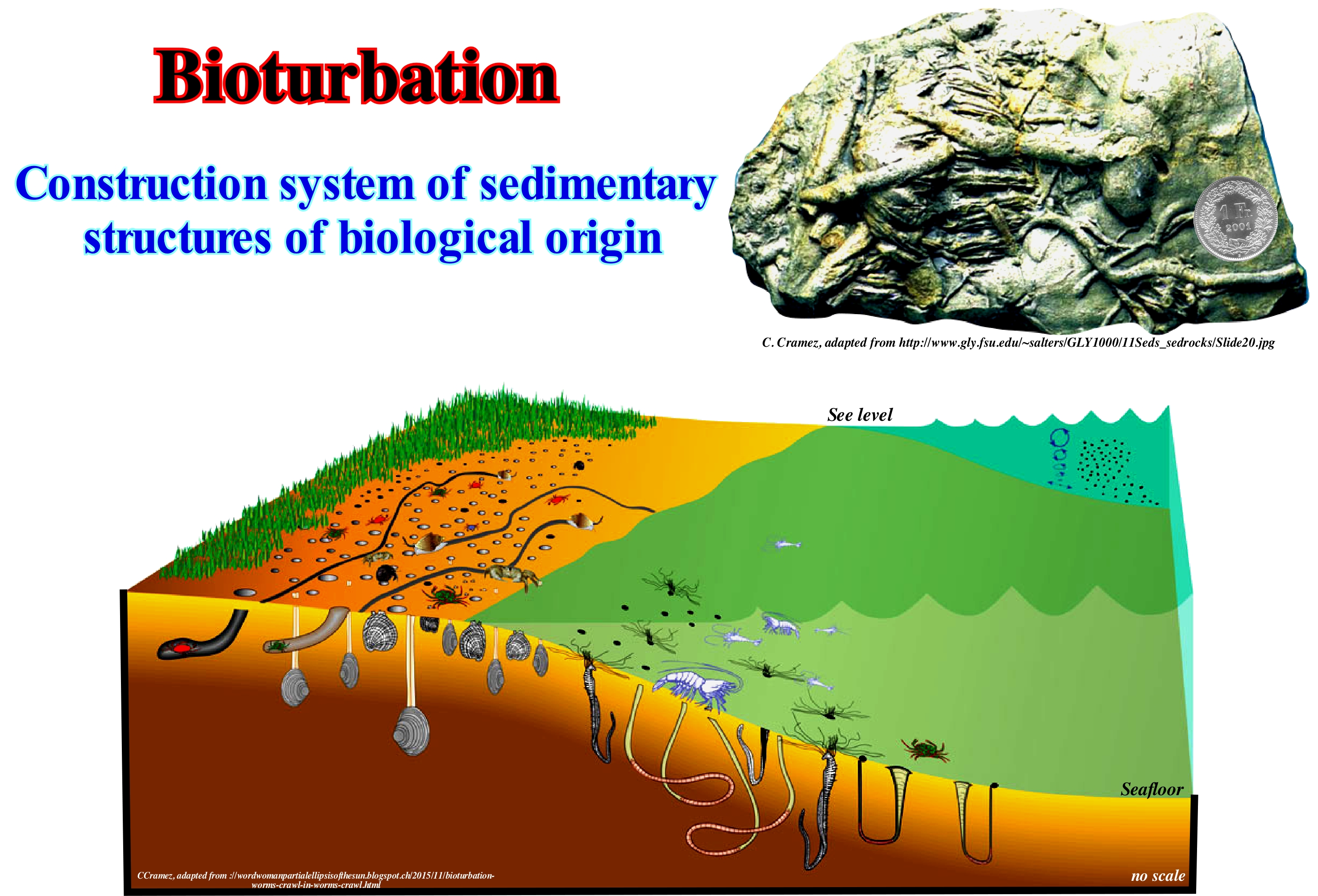
As illustrated in the ground sample, it can be said that bioturbation is a disorganization of the sedimentary layers deposited on the sea-floor by the activity of the organisms. Earthworms, ants, snails, centipedes, etc. are quite important in bioturbation. The importance of this bio-geological mechanism was first recognized by Charles Darwin who gave him his last book. In modern ecological theory, bioturbation is considered as the typical example of ecosystem engineering by modification of geochemical gradients and redistribution of food resources, viruses, bacteria, etc. From the point of view of evolution, recent works, strongly, support the idea that bioturbation played a very important role in the evolution of metazoa at the end of Precambrian. The bioturbation produced by the excavating animals neutralizes, largely, the compaction, since they modify the sediment properties, such as porosity, permeability and, above all, spatial homogeneity. In fact, these properties determine the number and diversity of the micro-environments, that is, the places available to the different organisms. In the aquatic sediments, the texture controls the diffusion of the soluble and resistance to the flow induced by currents and waves of the sea inside the sedimentary layer. In soils, texture controls the infiltration of rain-water, which is crucial for the biological functioning of soils, since they determine the ease with which plants extract the food and reagents available for microbial metabolism from water. Bioturbation also allows geoscientists to determine whether a sedimentary layer is in its original position or whether it has been inverted by tectonics.
(*) Earthworms, digging small holes to move inside the soil increase their porosity. In this way, rain-water can penetrate through these pores and can reach greater depths. For this and other reasons, the abundant presence of earthworms is, often, considered an indicator that the soil presents suitable conditions for the survival of the plants to be sown by the farmer (https://www.webartigos.com/artigos/bioturbacao- of-soil / 89524).
Biotype.......................................................................................................................................................................................................................................................Biotype
Biótipo / Biotype / Biotipo / Biotyp / 生物型 / Биотип / Biotipo /
Space where a biocenosis lives (set of living beings, animals or plants that coexist in a certain space). The biotype and associated biocenosis are in constant interaction. Both constitute an ecosystem, which can be defined as the set formed by an association or community of living beings (biocenosis) and its geological, edaphic (relating to soils that is the natural habitat of plants), hydrological, climatic, etc.
See: « Biostratigraphy »
Biozone....................................................................................................................................................................................................................................................Biozone
Biozona / Biozona / Biozone / 生物带 / Биозона / Biozona /
Elementary division of biostratigraphy based on the appearance or disappearance (extinction) of a certain species. Theoretically, the biozones are synchronous. They represent, laterally, the same time interval. In practice, the notion of synchronism is difficult to apply. A species may need thousands of years (even millions) to spread across the surface of the globe. Its occurrence in the stratigraphic records will not be done at the same time in the different points of the planet. The synchronism of the biozones is accepted for the ancient geological formations, but for the recent formations the notion of synchronism is controversial.
See: « Formation (geological) »
&
« Taxon »
&
« Biostratigraphy »
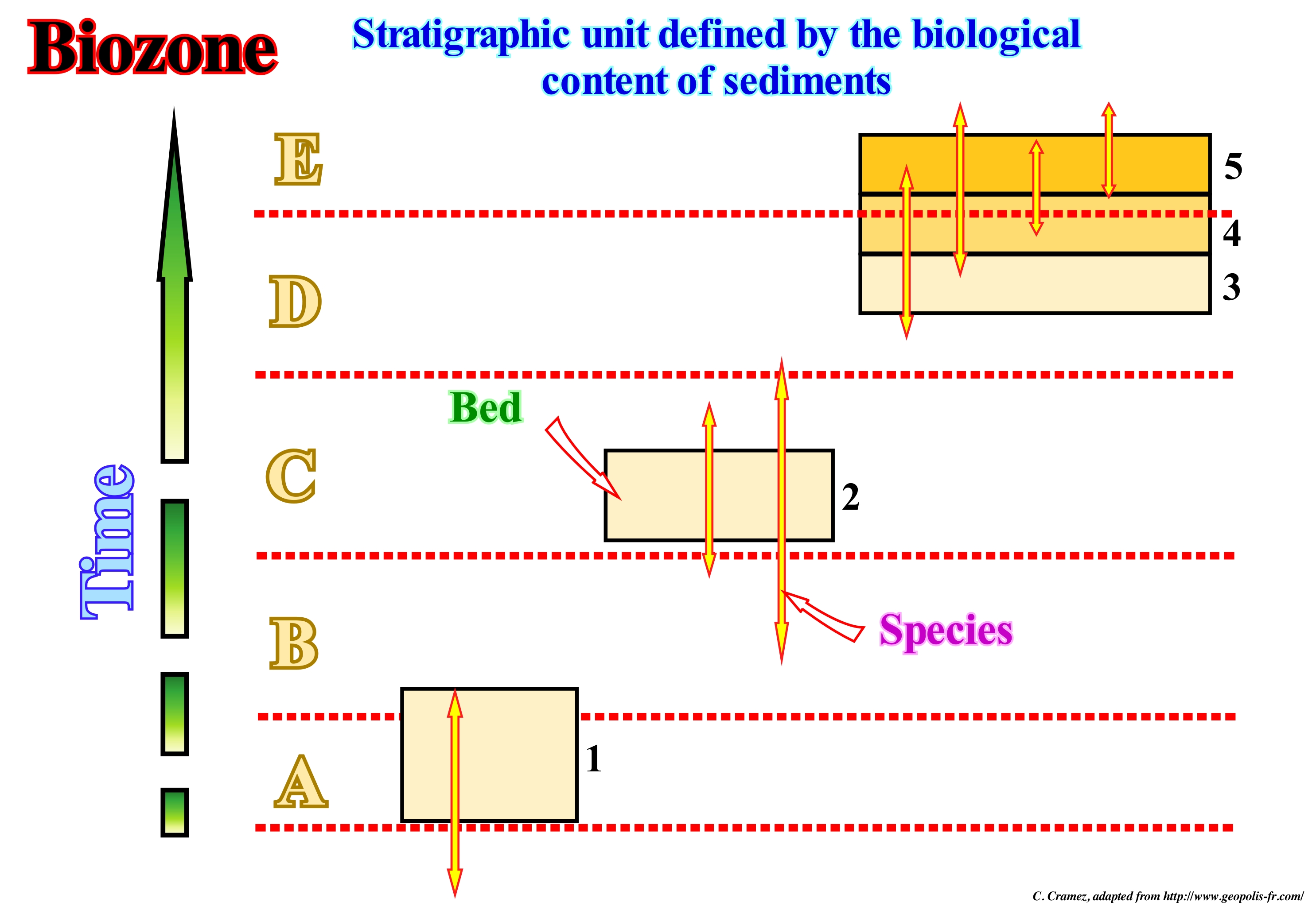
Fossils are remains or traces of animals or plants that existed in past geological times and were conserved by fossilization (a process by which the organic matter that makes up living beings is replaced by mineral substances) or printed on the rocks (usually in the stratification plans which correspond to more or less important non-deposition gaps). Fossils, in general, are used to define time units (biozones) as short as possible, to correlate with possibly heterogeneous lithological intervals. Biozones called, also, biostratigraphic zones or biostratigraphic units, are stratigraphic intervals (set of layers or groups of layers) defined on the basis of their characteristic fossils*. Depending on the group of fossils taken into account in the same sedimentary interval, different biozones, which often overlap: (i) Association (or cenozones) Biozones defined by the concomitant association of fossils of several taxa which form an association in such a way as to differentiate them from the adjacent layers (the distribution of a taxon may be greater than the biozone) ; (ii) Distribution, Extension or Existence Biozones (acrozones), as, in this example, layers (1), which are defined by the appearance and extinction of a species ; (3) Interlacing Biozones, such as layers (3), (4) and (5), which are delimited by the appearance of a species, until the next. In the distribution biozones can be considered several types: a) Biozone of Total Distribution ; b) Biozone of Concomitant Distribution or Biozone of Concomitance or Coexistence ; c) Oppel Biozone, in which taxa are selected so as to constitute a good geochronological criterion and its boundary coincides with that of the next biozone, so that there is a geological time division and d) Biozone of consecutive distribution or biozone of lineage or phylozone (constituted by the set of strata containing samples representative of a line segment or direction of evolution or development, limited by changes in characteristics). If different species belong to the same genus, it is called the "Phylozone" range zone. The Acme or Apogee Zone of a species, corresponds to the layers, which contains more representatives of this species. This zone can not be correlated over great distances, since the quantity of representatives of the species depends, mainly, on the ecological conditions. A biozone should not be confused with an ecozone or biogeographical domain, which is an area of the Earth's surface where plants and animals have developed, more or less, isolated for long periods of time and are separated from other plants and animals by geological elements such as oceans, deserts or mountains. The geological time represented by a biozone is a biochron, which is used in biochronology. It can be said that biostratigraphy is the segmentation of time in biozones, i.e., in volumes of rocks that underline the vertical and horizontal (geographical) extent of two or several taxa, which do not necessarily occupy the same space, assuming that the biozones are isochronous in all the places and that therefore one can make correlations between different areas. However, it should not be forgotten that: A) There must be preserved fossils, which is not the case, for example in the Precambrian, in the metamorphic rocks and especially in the igneous rocks ; B) It should be possible to separate different species, which is not always easy in particular when there is a continuous evolutionary slip ; C) The spaces occupied by the species are limited by the climate, natural barriers, etc. ; D) When a species migrates from one zone to another, the extension time is reduced where it migrates / place of origin. A biozone is not a unit of time and some bio-horizons are diachronic (http://www.juvenat.com/ admin / ent / uploads / docs / 1320354305.pdf). Recall that biochronology is the time correlation of biological events from fossils from the use of fossil clusters that are not linked to stratigraphic sections (as opposed to biostratigraphy, where they are). Collections of terrestrial mammal ages have been defined for all continents except Antarctica, and most are interrelated, indirectly, through known evolutionary lineages. A combination of argon-argon dating and magnetic stratigraphy allows a direct temporal comparison of terrestrial events with climatic changes and mass extinctions. (https://en. wikipedia.org/wiki/Biochronology)
(*) The characteristic fossils are remains or vestiges of living beings, contemporary to the genesis of the rocks in which they appear, whose populations had a short life span and a large area of dispersion. The characteristic fossils are also called guide fossils or index fossils, are of great chronostratigraphic interest and are fundamental for the study of stratigraphy because they date the relative age of the layers where they occur.
Biozone of Abondance........................................................................................................................................Biozone d’abondance
Biozona de sobreposição / Biozone de apogeo / Biozone Association (oder cenozone) / 生物区 / Biozone из Абонданс / Biozona di distribuzione concomitante /
Biozone holding several species. Synonym of Biozone of Coincident Extension.
See: « Biozone »
Biozone of Association.....................................................................................................................................Biozone d’association
Biozona de Conjunto (Cenozona) / Biozonas de conjunto (cenozone) / Biozone Association (oder cenozone) / 生物带协会(或cenozone) / Biozone ассоциация (или cenozone) / Biozona di associazione (o cenozona) /
Biozone defined by the concomitant association of fossils of various taxa that form an association in such a way that differentiate them from adjacent layers (the distribution of a taxon may be larger than the biozone). Synonym of Cenozones.
See: « Biozone »
Biozone of Extension..................................................................................................................................................Biozone d'Extension
Biozons de extensão / Biozona de extensión / Biozone Erweiterung / 生物带扩展 / Расширение Biozone / Zona di distribuzione totale o zona di distribuzione di un taxon /
Biozone defined by the appearance and extinction of a species, within which one can differentiate: a) The zone of extension of a taxon ; (b) The concomitant zone or zone of concomitance or coexistence ; c) The Oppel zone and d) The zone of lineage or phylozone (consisting of the set of strata containing specimens representative of a line segment or direction of evolution or development, limited by changes in characteristics).
See: « Biozone »
Biozone of Interval..............................................................................................................................................................Biozone of Interval
Biozona de intervalo / Biozone d’interval / Biozona de intervalo/ Biozone des Intervalls / 间隔BIOZONE / Biozone интервала / Biozona di intervallo) /
It is characterized by the absence of some or all of the taxa that define it. It underlies the interval in which a taxon has disappeared or another one has not yet appeared or another taxon is present, but it has already disappeared or no other distinct has appeared.
See: « Biozone »
Bird-Foot Delta (Finger delta, digitated delta)...................................................................................Delta em patte d'oiseau
Delta Digitado (em pata de ave) / Delta digitado / fingert Delta / 手指三角洲 / Пальцевидная дельта / Delta del piede di uccello /
When the delta plain extends through several narrow, long, finger-shaped lobes. Synonym of Finger Delta.
See: « Delta »
&
« Finger Delta, Digitated Dela »
&
« Delta Plain »
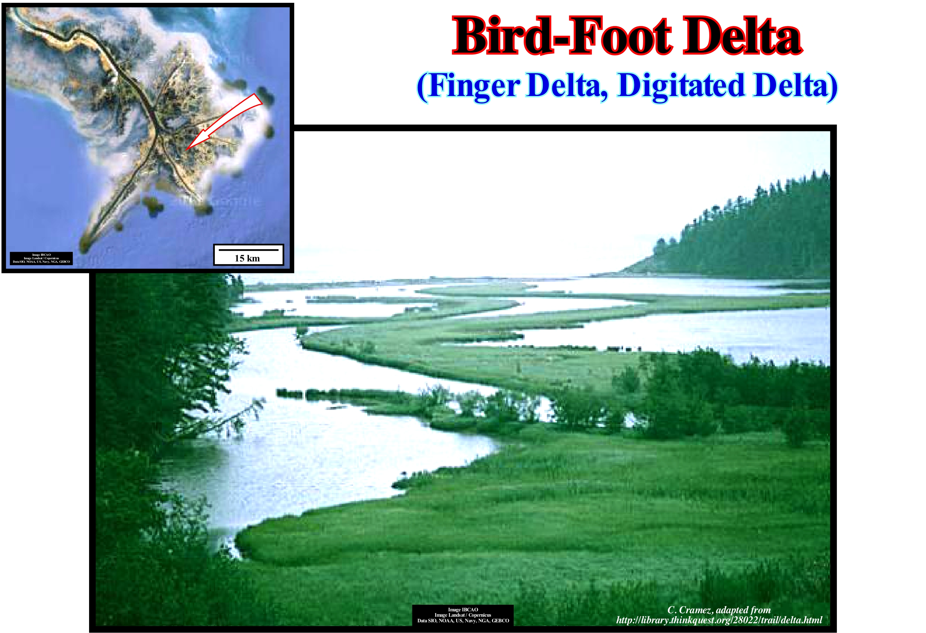
The shape of a delta depends on: (i) Amount of water and sediments transported by the river ; (ii) River water velocity ; (iii) Speed and force of the sea-waves (or of a lake), currents and tides. When a significant amount of sediment is transported to a calm water-body (sea or lake) a delta is formed in a bird's foot (or digitized), because the distributive can transport and form through the water-body long "fingers" (of the paws) of sediments, as illustrated in this photograph of the Delta Scotts RoboInfo (Canada). The most celebrated delta in bird's foot is, of course, the Mississippi delta building, which underlines the invasion of the Gulf of Mexico by remains of glacial deposits (upper left corner of this figure). The hydrographic systems of the Mississippi and Missouri rivers collect the eroded fragments of almost half of the United States and transport them to the Gulf of Mexico. Since the currents enter the Gulf of Mexico, the flow velocity decreases, abruptly, reducing their capacity to transport, in suspension, sludge and sand, causing their deposition. The formation of this delta building is well known to all geoscientists and can be summarized as follows: (a) When the glacier cap covered most of North America (about 18 ka), the Mississippi region was exposed ; (b) With the glaciations and deglaciations that caused eustatic variations, the Mississippi and its distributives created incised valleys (during the glaciations) and flooding plains (during the deglaciations) ; (c) The rapid flow and the important sedimentary influx from the glacial deposits, created a network of intertwined rivers and associated deposits ; (d) Since the discharge has decreased, the flow has become meandering with the formation of a meander belt ; (e) Sediments still carried by currents, particularly, in the form of loess (sediment-sediment transport from the north and west of the region), have been re-deposited in the Gulf of Mexico in layers (deltas) a few feet thick, which means that the Mississippi Delta delta is an overlap of layers (deltas) that are nothing other than the re-sedimentation of ancient glacial deposits.
Bitumen....................................................................................................................................................................................................................................................Bitume
Betume / Betume / Bitumen / 沥青 / Битум / Bitume /
Generic term applied to flammable natural substances of dark colour, with variable hardness and volatility and composed, mainly, by a mixture of free hydrocarbons and oxygenated bodies. When bitumen is associated with mineral matter, the non-mineral constituents are meltable and soluble in carbon disulfide. Petroleum, asphalt, natural mineral waxes and asphaltites are all considered as bitumen. For certain geoscientists, bitumen is, simply, the heaviest and most viscous form of crude oil which at room temperature has the consistency of a molasses and needs to be heated or diluted to be transported by pipelines.
See: « Asphalt »
&
« Petroleum »
&
« Hydrocarbon »
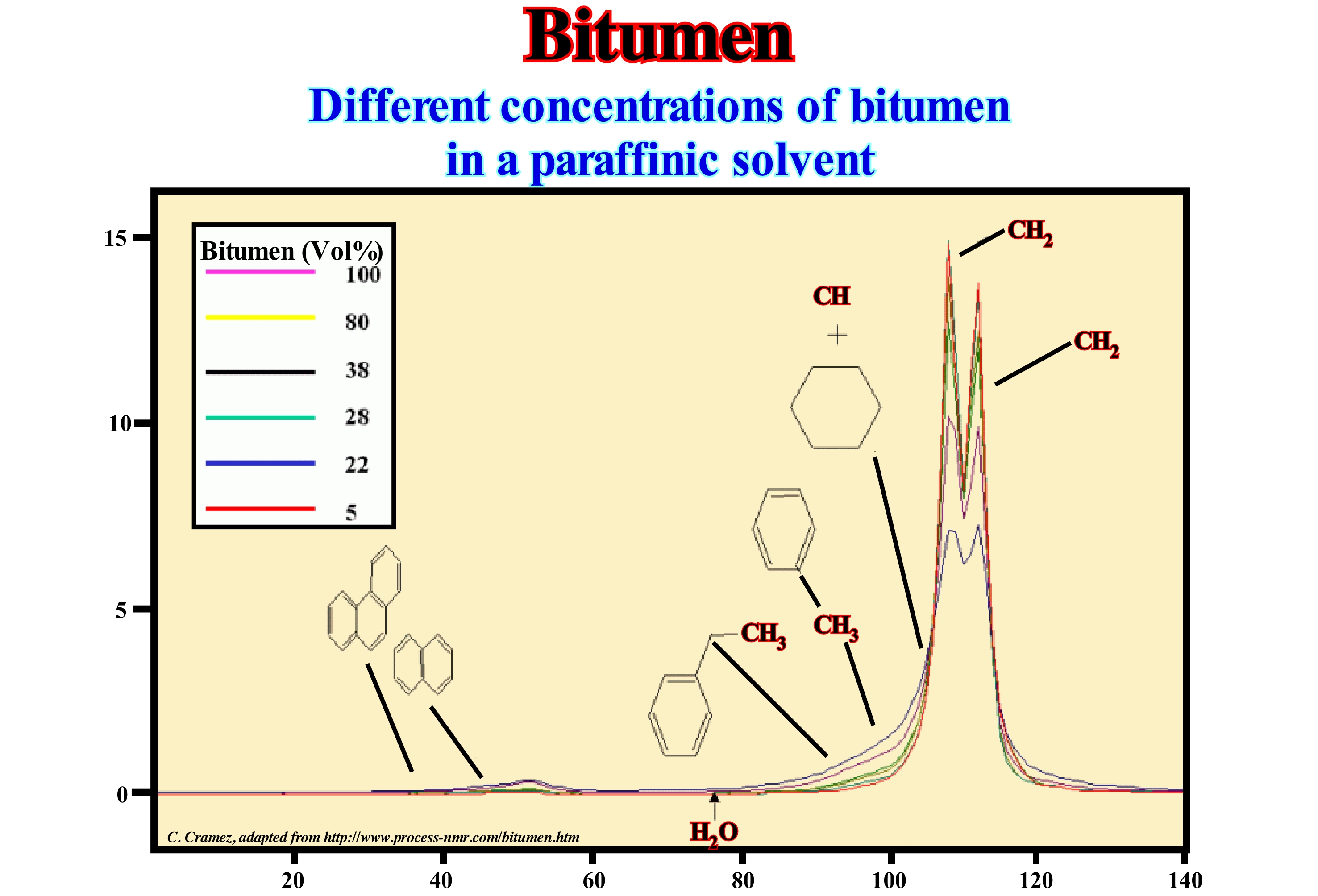
Bitumen is a category of highly viscous, black, sticky, and totally soluble organic liquids in carbon disulfide. Bitumen can occur, naturally, but can also be obtained from the refining of petroleum. In nature, deposits of bitumen are formed from the remains of algae and other living beings, which when they die are deposited in the sludge of the sea-floor and lakes. Since burial increases, pressure and heat transforms the organic remains into bitumen, kerogen* or petroleum. Bitumen is, mainly, used to coat the surface of the road and to insulate the roofs of houses, as well as for the caulking of wooden boats. The meaning of the term bitumen varies, widely, according to the nationality and profession of geoscientists. Canada has the world's largest reserves of natural bitumen. The tar sands of the Athabasca, which are exploited in the open air, extend for more than 140,000 km2 and are the second largest proven oil reserves in the world. Due to the rise in the price of a barrel of oil since 2003, oil production from bitumen is currently (2006) profitable. In 2006, in Canada, average oil production from bituminous sand was about 1.1 Mb (170,000 m3) per day and some geoscientists think it can reach 4.4 Mb (700,000 m3) per day, in 2020 (if the price of oil continues to rise). The total amount of oil that can be extracted from the bituminous sands of the province of Alberta (Canada) is estimated at about 310 Gb (50 x 109 m3), which means a daily production of about 4.4 Mb for about 200 years.
(*) Insoluble organic matter, which occurs naturally in source-rocks and can produce oil after heating. Kerogen is the portion of natural organic matter that can not be extracted using organic solvents. Typical organic constituents of the kerogen are algae and woody material from plants. Kerogens have a high molecular weight relative to bitumen, or soluble organic matter. The bitumen forms of the kerogen during the generation of petroleum. Kerogens are described as (i) Type I, consisting mainly of algae and amorphous kerogens and highly prone to generate oil ; (ii) Type II, mixed terrestrial and marine material that can generate oil with a lot of wax and (iii) Type III, land-based material that normally generates gas (http://www.glossary.oilfield.slb.com/ Terms / k / kerogen.aspx).
Bituminous Sand (Tar sand, oil sand)...........................................................Sable betumineux, Sable asphaltique
Areia Betuminosa / Arena bituminosa / Ölsand / 油砂 / Битуминозный песок / Olio sabbia /
A sandy deposit, poorly consolidated, containing organic matter impregnated with bituminous material consisting, mainly, of hydrocarbons from which oil can be extracted. Sands containing asphalt or bitumen, from which hydrocarbons may be, potentially, extracted by distillation. The term bituminous sand is synonymous with Asphalt or Petroliferous Sand, (combination of clay, sand, water and bitumen).
See: « Tar Sand, Oil Sand »
&
« Bitumen »
&
« Asphalt »
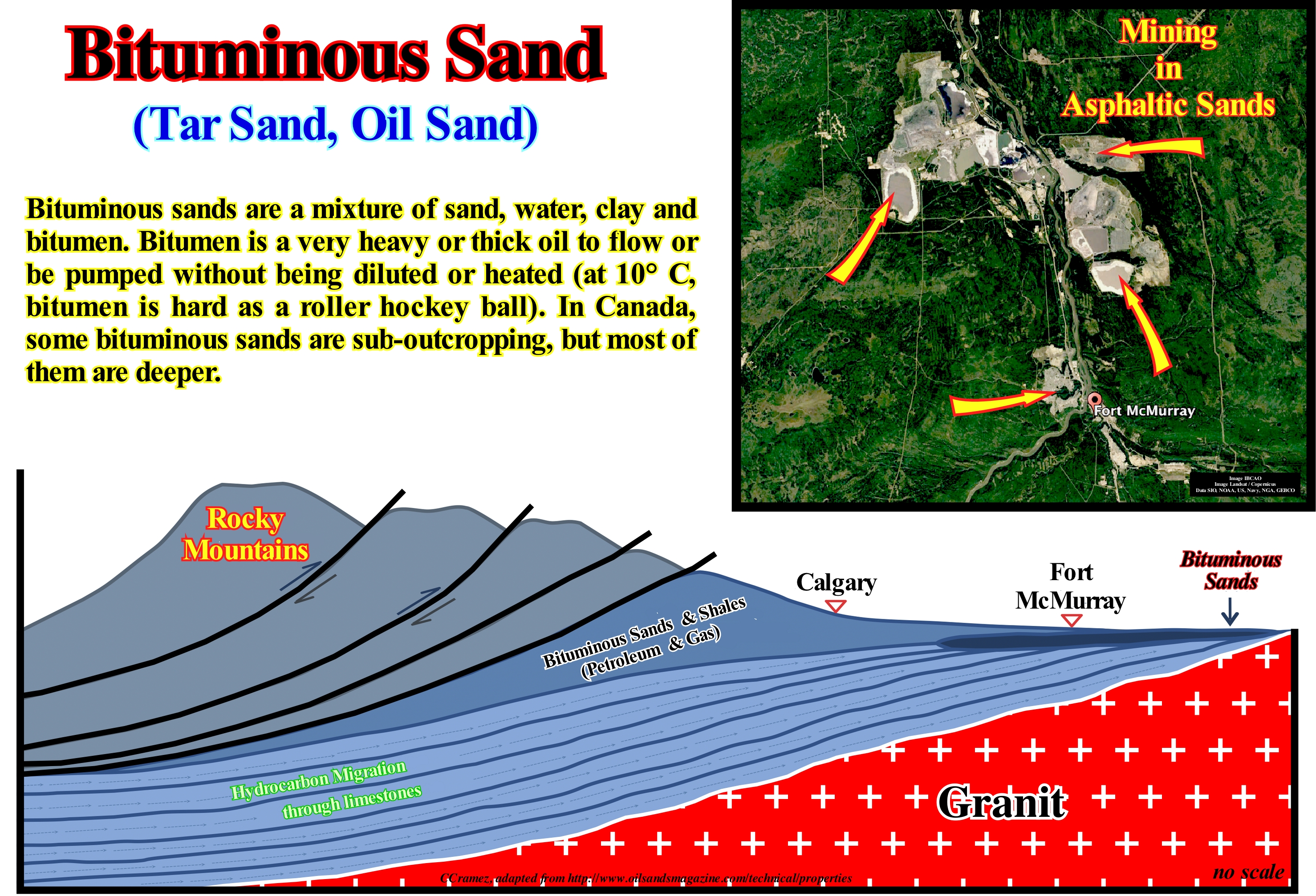
Bituminous sands (or oil sands) are geological formations, which contain heavy oil sometimes called bitumen. They are composed of approximately 80% sand and clay, 10% water and about 10% petroleum. Each grain of sand is surrounded by a film of water, which, in turn, is surrounded by an oil film. In general, the bituminous sands do not appear. They are covered by other sedimentary formations. However, in order to be economically viable, burial should not be too large (between 300 and 500 meters). The mobility of oil is an important factor in the profitability of a tar sands project. When the price of oil was around $ 20 per barrel (before the peak oil production was reached, if it was already, i.e. before the end of Lahererre cheap oil), the vast majority of the accumulations of sand were non-economic. With the price of a barrel around $ 80-100, which in terms of hours of work is still cheaper than in 1982, the exploitation of some of these accumulations just begins to be profitable. Note that in 1982, during the first oil shock, it took 11 hours of work by an average American to buy a barrel of oil against 8 hours between 2007-2008. The resources (not to be confused with reserves) of bituminous sands in the province of Alberta, Canada, are estimated at 1.7-2.5 Tb (tera = 1012), which is one of the largest in the world. However, it is unlikely that these resources can all be extracted economically, that is, they become reserves. Another country very rich in bituminous sands resources is Venezuela (Orinoco Belt).
(*) Resources means the quantity of a mineral or existing or undiscovered rock that may possibly be extracted, but which, for economic or technical reasons, can not currently be extracted, while reserves of a particular mineral or rock (such as petroleum) are the part that can now be extracted from the land at a profit. In other words, resources are all that could turn into reserves if there were no technological and economic constraints. Resources can turn into reserves when technology, financing, time and savings are favourable.
Black Shale........................................................................................................................................................................................................................Argile noire
Argilito negro / Arcilla negra / Schwarzen Schiefern /黑色页岩 /Чёрная глина / Scisto Nero /
Shale carbonaceous, sometimes, with carbonate, finely laminated (fissile), black in colour, rich in organic matter (5% or more carbon) and sulphides (especially iron sulphide, usually pyrite), with abnormal concentrations of certain trace elements (uranium, vanadium, copper, nickel, etc.) deposited in anoxic and reducing environments. Synonym of Biopelite.
See: « Asphalt »
&
« Petroleum »
&
« Clay »
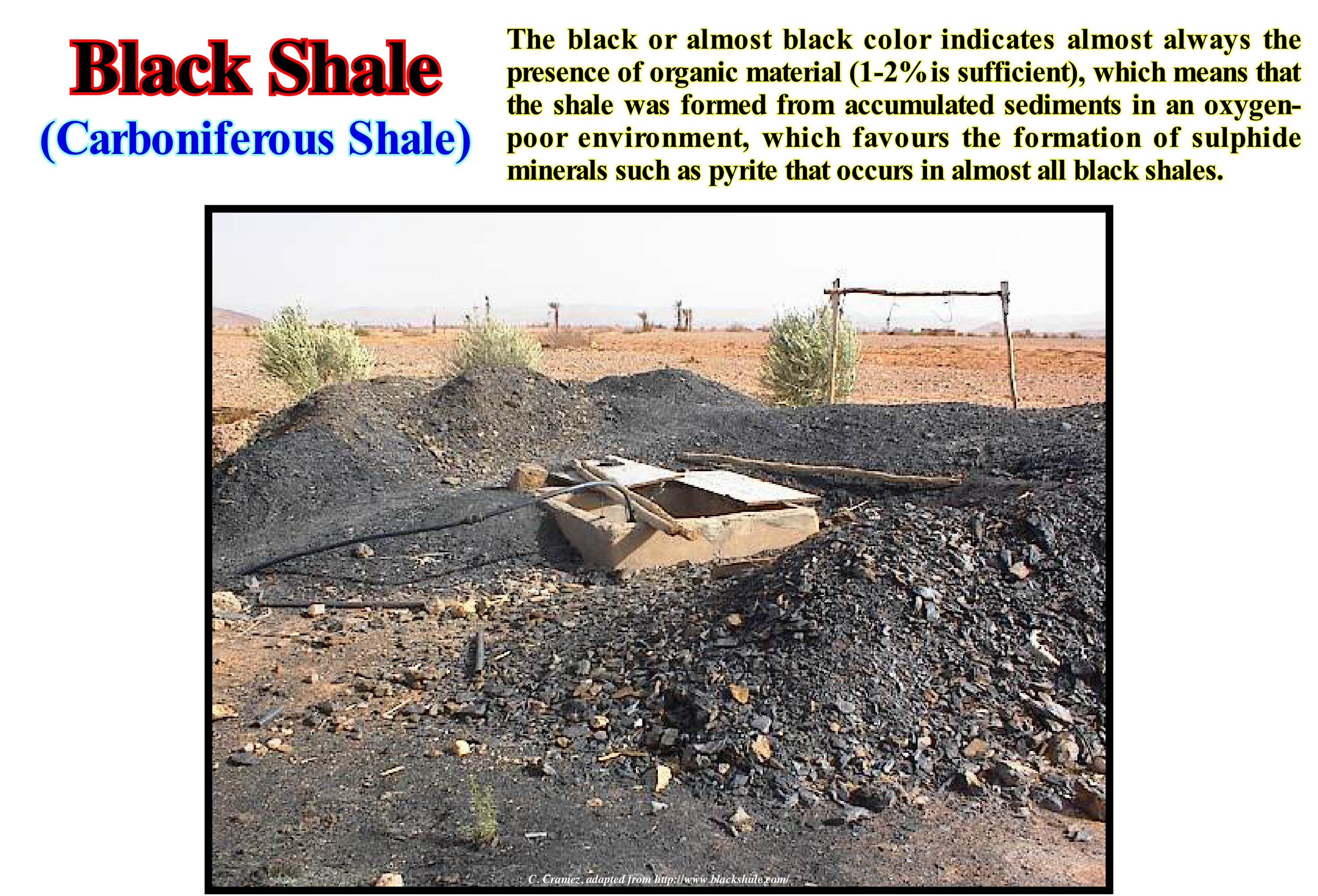
Some geoscientists call the black shales bio-pelites. In black shales fossils (mainly planktonic and nektonic) are generally preserved in the form of carbonate films, graphite or even by replacement pyrite. Black shales are very common in the Mesozoic and Paleozoic strata and they are very good oil source-rocks, when buried, sufficiently, so that their organic material can reach the oil window. In North Africa and Arabia, the Silurian's "hot shales" are black shales and certainly the main oil drivers, as is the case in Libya, in particular, in the Murzuq basin. These black shales of the Silurian were deposited in a very special way. They fossilize the glacial topography created by the great glaciation that occurred during the Ordovician. This topography corresponds to a series of glacial valleys, more or less, important, oriented North-South. When the absolute sea level began to rise, during the Early Silurian melting (Silurian ingression), the sea invaded the glacial valleys of the Ordovician creating anoxic and reducing environments very favourable for the formation and preservation of organic matter. It was during this initial phase of marine ingression that these black shales or "Hot Shales" were deposited, as they are known in the region and form the basis of the Tanezzuft formation (Llandoverian between 428-438 Ma). These black shales are illustrated in this photo. Black shales, which are the main source-rocks in the Murzuq basin, was not deposited throughout the sedimentary basin, but only at the bottom of the filling of the Ordovician glacial valleys. They are covered by retrogradational sediments (transgressive sediments as certain geoscientists say) that cover the entire sedimentary basin that pass, gradually, to siltstones and regressive sands in Late Middle Silurian (Akakus formation). Note that in geology the term sedimentary basin, generally, means a depression of the Earth's surface formed by subsidence of the lithosphere in which sediments are deposited. However, today, the term sedimentary basin or simply basin can have several meanings. That is why we advise to always specify in what sense such terms are used. For example, they may have only a geographic value (a set of sedimentary rocks of different ages that have settled in a particular geographic region), such as the Paris Basin (France), which does not correspond to any sedimentary basin or the Neunquen Basin (Argentina), which corresponds to a stacking of sedimentary basins. Likewise, a rift-type basin or back-arc basin designates a particular sedimentary basin of a given basin classification. In this glossary, for example, among the different classifications of sedimentary basins, we adopted the classification of sedimentary basins proposed by A. Bally and Snelson (1980), which is based on the origin of subsidence that created most of the space available for sediments (the other part is created by eustasy). In sequential stratigraphy, within a sequence-cycle, which is nothing other than the filling of a sedimentary basin during a 3rd order eustatic cycle (duration between 0.5 and 3-5 My), the term basin is, in general, used to express the area where the water column is most important.
Blind Valley (Steephead)..........................................................................................................................................................................Vallée Aveugle
Vale cego / Valle ciego / Reculée, Blind Valley / 盲谷 / Закрытая (слепая) долина / Valle cieco /
A steephead valley or blind valley is a deep, narrow, flat bottomed valley (often with reversing dip) with an abrupt ending. Blind valleys are created by a stream flowing within the permeable rock and eroding it from within, until the rock above collapses opening up a steep narrow valley which is then further eroded by the stream running across the impermeable valley floor. Often synonym of Dead Valley.
See: « Karst »
&
« Sinkhole »
&
« Dry Valley »
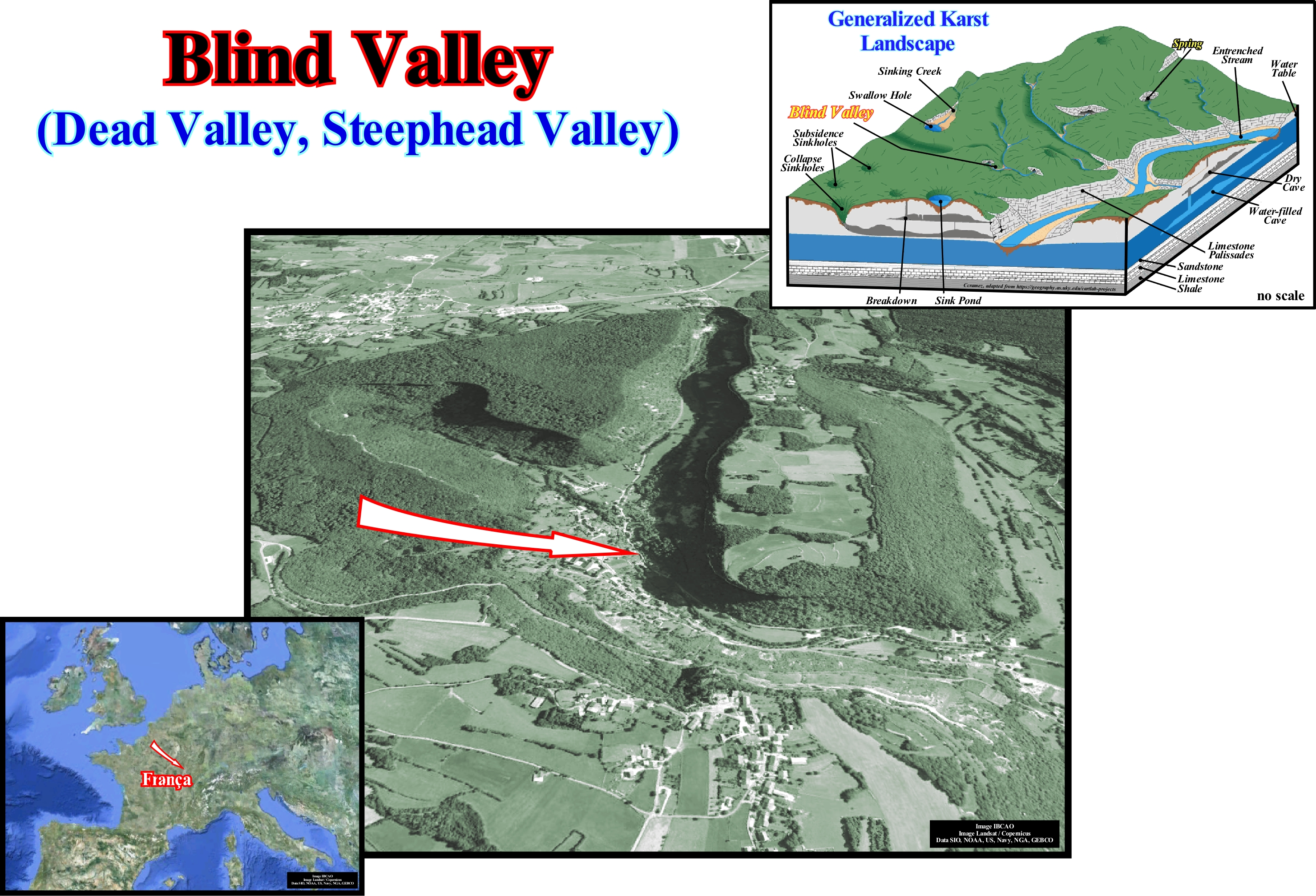
As illustrated in this figure, a blind valley or dead valley is a deep, narrow valley with a flat base that ends up abruptly upstream. Blind valleys develop in karstic calcareous regions, where a permeable layer of rock rests on a layer or set of impermeable layers such as marls (type of limestone containing 35-60% clay, light to dark gray, brownish or reddish with fine or very fine grains, some of which may be distinguished by the naked eye), which are considered as a substrate. Blind valleys are created by flowing streams within the permeable rock, which corrode the rock from within, until the underlying rock collapses opening a steep and narrow valley, which is later eroded by the stream running through the valley on the impermeable rock. At the head of a blind valley, that is, at the upstream end, as shown in this figure, the current emerges from the rock as a spring. Well-known examples of this type of valley occur in the French Jura, such as the "Reculée de Baume" and "Reculée d'Arbois*" illustrated above. In North America, blind valleys have been identified in many areas, particularly the Paleozoic Plateau, where the blind valleys, sometimes, have a complex origin, whether glacial or hydrological. They can be simple and short (a few kilometers), or rather long and branched with dead ends. The width is variable, but more, often, limited to a few hundred meters to a kilometer, with the lower edges, sometimes, asymmetrical, dominating imposing cliffs between 60/250 meters. A blind valley ("reculée" in French), as illustrated above, terminates upstream with a circus bounded by more or less vertical walls, at the base of which a stream is almost always born, which is sometimes the resurgence of a hydrological system, which is infiltrated through the subterranean caves much sought after by speleologists, since the system may have several kilometers.
(*) The Arbois blind valley is located on the territory of the towns of Arbois, Mesnay and Planches-près-Arbois. It is around 5 km long and 1 km wide. It is crossed by the Cuisance which has its source in the "Fer à Cheval" cique and in the Grotte des Planches. First north-oriented, it then branches westward at Mesnay towards the Bresse plain.
Blue Ocean...........................................................................................................................................................................................................................Océan Bleu
Oceano azul / Océano azul / Ozean Blau / 海洋蓝 / Открытый океан / Oceano blu /
Name used by certain geoscientists for the part of the ocean with a water-depth greater than 200 meters which, usually, having a blue colour. Contrary to what many people think, the blue colour of the ocean is not due to the blue colour of the sky, but, basically, to the absorption by the water molecules of the red photons of the sunlight.
See: « Physiographic (province) »
&
« Middle Sea Level »
&
« Major Storm Wave Base »
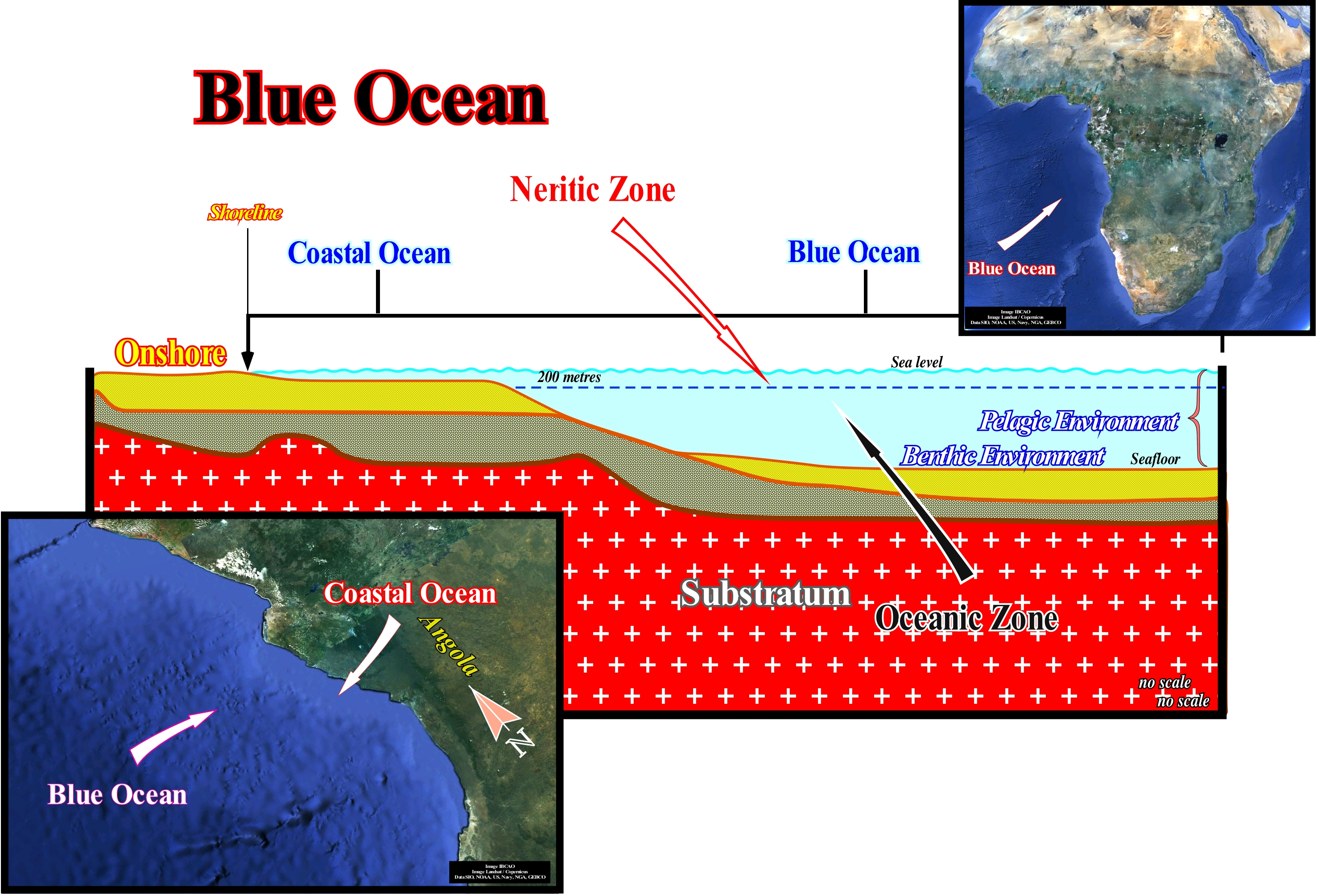
The ocean is immense. It covers more than 71 percent of the earth's surface. Of these 71%, 65% is considered blue ocean, that is, waters beyond the coastal shallows (coastal sea). There are several theories to explain the blue light of the oceans: (i) The wave-lengths of blue light are absorbed by the deep-water of the oceans and are scattered and reflected back into the eyes of the observers; (ii) The particles of water can help reflect the blue light and (III) The sea reflects the blue of the sky. Most of the time the sea seems to be blue because ,i.e., the colour our eyes see. But the ocean can be many other colours depending on the particles in the water, water-depth and amount of sunlight. The colours we see depend on the reflection of the wave-lengths of visible light in relation to our eyes. Wave-lengths of light pass through matter, differently, depending on the composition of the material. The wave-lengths of blue light are transmitted to the greatest depths of the ocean, while red wave-lengths are absorbed rapidly. Water molecules disperse blue wave-lengths and absorb light waves and quickly re-emit light waves in different directions. That is why there are, mainly, blue wave-lengths that are reflected to our eyes. Sometimes the oceans look green. This may be explained by an abundance of plant life or sediments from rivers flowing into the ocean. The blue light is more absorbed and the yellow pigments of the plants mix with the blue light waves to produce a green colour. Parts of the oceans appear milky, particularly, after a storm. This is due to the winds and currents associated with storms that shake the sand and sediments of rivers brought to the oceans. The ocean may also reflect the blue sky. However, this is only significant at relatively low angles and when water agitation is moderate.
Bluff......................................................................................................................................................................................................................................Falaise (Peu consolidée)
Arriba pouco consolidada / Acantilado (poco consolidado) / Cliff nur konsolidierten / 崖只是综合 / Отвесный берег / Scogliera (non consolidato) /
High bank or cliff, not very consistent, but very sloping, sometimes, rounded, facing either a plain or a water-body (sea, river or lake).
See: « Cliff »
&
« Yazoo-Type River»
&
« Talus, Slope »
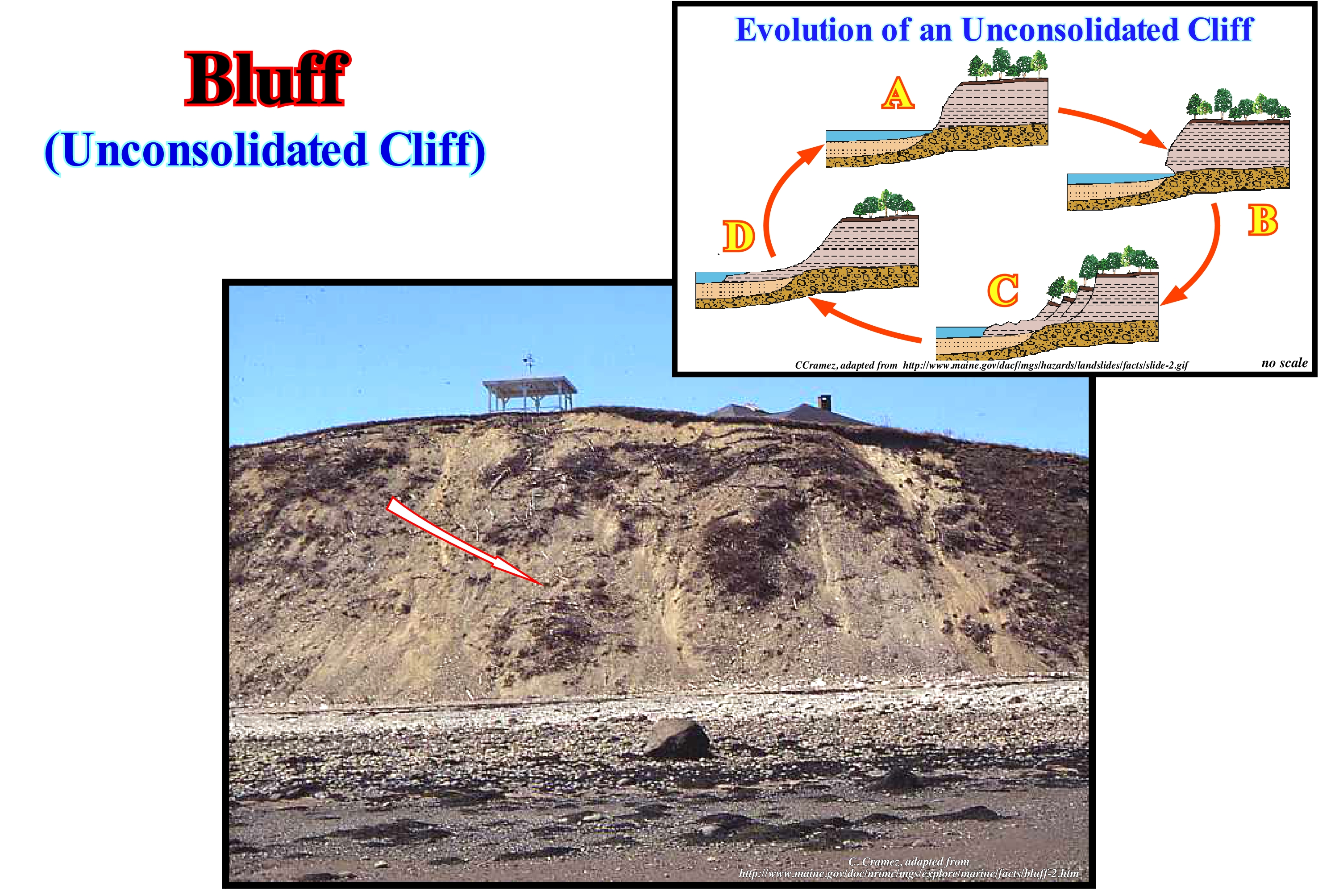
This photograph illustrates a unstable cliff, which borders a beach consisting mainly of gravel. The slope of the cliff is so unstable that it does not support any vegetation. The sediments that form it correspond to an old esker* (glacial environment) that is being, progressively, eroded by the sea-waves, which creates at the base of the bluff a mixture of sand and gravel. When a sedimentary basin does not have a continental shelf, which happens in a regressive interval, from a certain moment (shoreline coincident with the basin edge), a not very consolidated cliff can trigger gravity currents responsible of turbiditic deposits in deep-water. As suggested by E. Mutti, not all deep turbidite deposits are associated with a unconformity (P. Vail hypothesis), i.e., a significant relative sea level fall. An instability of the basin edge or shoreline (they are, coincident when the basin has no shelf) can create important gravity currents and the formation of submarine basin floor fans or slope fans in the deep-parts of the basin. When the amount of material removed from the basin edge, which may correspond to a bluff, since the basin has no continental shelf, it is large, which in general means that it is very rich in sand, are deposited the Mutti type I submarine lobes, which are, roughly, equivalent to the submarine basin floor fans of the P. Vail. When the amount of material take away from the basin edge is small (little sand and a lot of clay), are deposited the Type III submarine lobes (Mutti), which correspond, roughly, to the submarine slope fans of the Vail. When the amount of material carried by the turbidity stream is medium (Type II submarine lobes), submarine fans are deposited, which extend landward by turbidite channel-shaped deposits, which often correspond to the filling of the depressions between the lobes or to the retrogradational filling of the channels through which the turbidity current passed.
(*) An esker is a deposit of materials derived from the erosion caused by the melting of the glaciers, which appear, normally, at the bottom moraines and are made of clay, sand and gravel. The dimensions of the eskers are variable, reaching a few hundred meters wide and hundreds of kilometers long, as is the case in southern Algeria and Mauritania.
Blunt Delta (Cuspate delta)...............................................................................................................................Delta en croissant (Delta obtus)
Delta em crescente / Delta en media-luna / Stumpfdelta / 尖头三角洲 / Фестончатая (невыдвинутая) дельта / Delta mezzaluna (delta ottuso) /
When the delta plain, due to the erosive action of the sea-waves (or lake-waves), has a concave geometry towards the sea.
See: « Delta »
&
« Delta Front »
&
« Major Storm Wave Base »
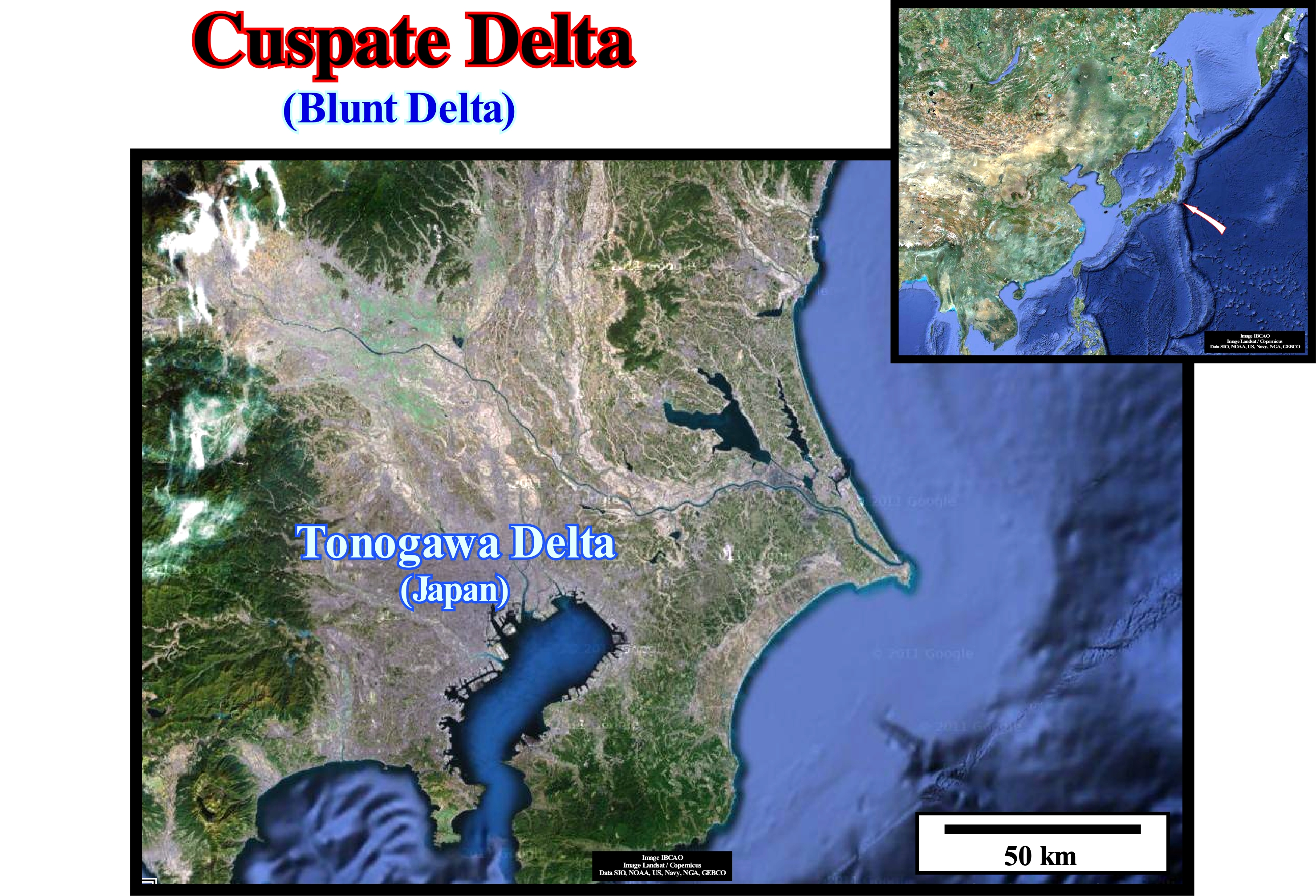
A cuspate delta is the delta that forms when a river drains in a shoreline, more or less, rectilinear subject to a strong swell, in such a way that sea-waves force the sediments to spread in two directions opposite from the mouth. An arrowhead is built, with crescent-shaped curves on each side. A blunt delta can not be confused with a rounded or arched delta (arcuate delta), since it forms when a river meets the sea in a place where the waves, currents and tides are strong, in the areas where the longitudinal currents maintains the edge of the delta trimmed and relatively smooth. These deltas are dominated by sea-waves and is the erosion of the waves that control the shape of the delta, since the vast majority of the sediments arriving from the mouth are diverted along the coastline. However, these deltas can have multiple energies. When the delta is tilted and with high energy, the sediment-deficient coastlines have little sand at the bottom and an offshore, relatively, deep. When the delta is, sightly, dipping with low energy, the shorelines are, usually, shaly with a fringe of coastal vegetation. In these deltas, the action of the incident wave is dissipated in a shallow-water offshore, which is not the case for most deltas. In general, deltas result from river and sea processes, and sediments transported by rivers are deposited when the stream enters a water-body without strong currents, such as a lake, lagoon, sea or ocean. The sediment deposition is enhanced when the water is salted, since the finer particles and, especially, the clayey ones, agglutinate in the salt water, forming larger particles. Other major factors that influence deposition are: (i) Type of sediment ; (ii) Local geological context ; (iii) Eustatic changes (absolute sea level, which is supposed to be global sea and referenced to the Earth's centre) and relative sea level (local sea level and referenced to any point on the Earth's surface and is the result of the combined action of absolute sea level and tectonics) ; (v) Plant growth ; (vi) Human Impact, etc. Typical examples of large delta buildings are associated with the Mississippi, Ganges, Bramaputra, Rhone, Rhine, Rhone, Danube, Nile rivers. The Ebro Delta in Spain, the San Francisco Delta, between Sergipe and Alagoas in Brazil and the Tonogawa Delta in Japan, are typical cuspate deltas. The Tonogowa delta, for example, illustrated in this figure, is a blunt delta (cuspate delta or delta in arrowhead), which forms when a river deposits sediments, which it transports, on a more or less straight coastline, but dominated by very strong waves that oblige the sediments to spread, perpendicularly, to the mouth of the river, but in opposite directions. Another well-known blunt delta is the Tiber delta (Italy), which began to form between 13,000 and 7,000 years BC, when the deep river valley (incised valley), which the river dug during the Wurmian glaciation* (characterized by having produced a significant falling of absolute or eustatic sea level, at least in the Northern Hemisphere), was, partially, flooded by the rising of the absolute level rise induced by the ice melting. Initially, during the marine ingressions, the delta was the bottom of a bay and its geometry, globally, retrogradational. About 8,000 BC, the delta began to prograde seaward (sedimentary regression) and transformed, gradually, to about 6,000 BC, in a cuspate delta (or in arrowhead), mainly due to the action of the waves. The interaction between sea level rise induced by the melting of ice caps, terrigeneous transport and wave energy, explains the evolution of the Tiber region over the last 18,000 years. Several types of delta can be considered as a function of the dynamics of the delta and the shape of the delta plain: (i) Abandoned Delta or Dry Delta ; (ii) Alluvial delta ; (iii) Arctic Delta ; (iv) Arcuate Delta ; (v) Atrophied Delta ; (vi) Complex shaped Delta or Polymorphic Delta; (vii) Fingers Delta or Digitated Delta ; (viii) Flow Delta ; (ix) Closed Delta ; (x) Gilbert-type Delta ; (xi) Lava Delta; (xii) Lobated Delta ; (xiii) Tidal Delta ; (xiv) Submarine Delta ; (xv) Storm Delta; (xvi) Wave Delta ; (xvii) Ebb Delta, etc.
(*) Last glacial period, also known as Ice Age, Wisconsian Glaciation, Würm Glaciation, Wurmian or Laurentian, is the designation given to the last episode of Earth's glaciation recorded during the present geological age. It took place during the last part of the Pleistocene, between 110 k and 10 ky before the Present and is the best known of recent glaciations. This cold period was followed by another warming that continues today and during which the glaciers are thinning. However, even in the Holocene there were variations in temperature and ice thickness, as suggested by the Little Ice Age between the 13 th and 19 th centuries. The Holocene is considered by most geoscientists to have a interglacial period within a large glacial age, since the poles and highlands of the mountain are still covered with ice. However, it can be said that since the end of the Little Ice Age, dating back almost 150 years, the thinning of the glaciers is almost continuous. They have lost about a third of their total volume which means that the average thickness has decreased by 30 cm / year over this period.
Bordeland (Continental slope)..................................................................................................................................................Talus Continental
Talude continental / Talud continental / Kontinentalalagfall / 陆坡 / Континентальный склон / Pendenza continentale /
Part of a continental margin, generally, divergent, located between the platform and the continental rise. The continental slope has a relatively strong slope between 3-6° and is mostly composed of deep-water sedimentary rocks, usually argilaceous rocks.
See: « Continental Shelf, Shelf »
&
« Basin Edge »
&
« Talus, Slope »
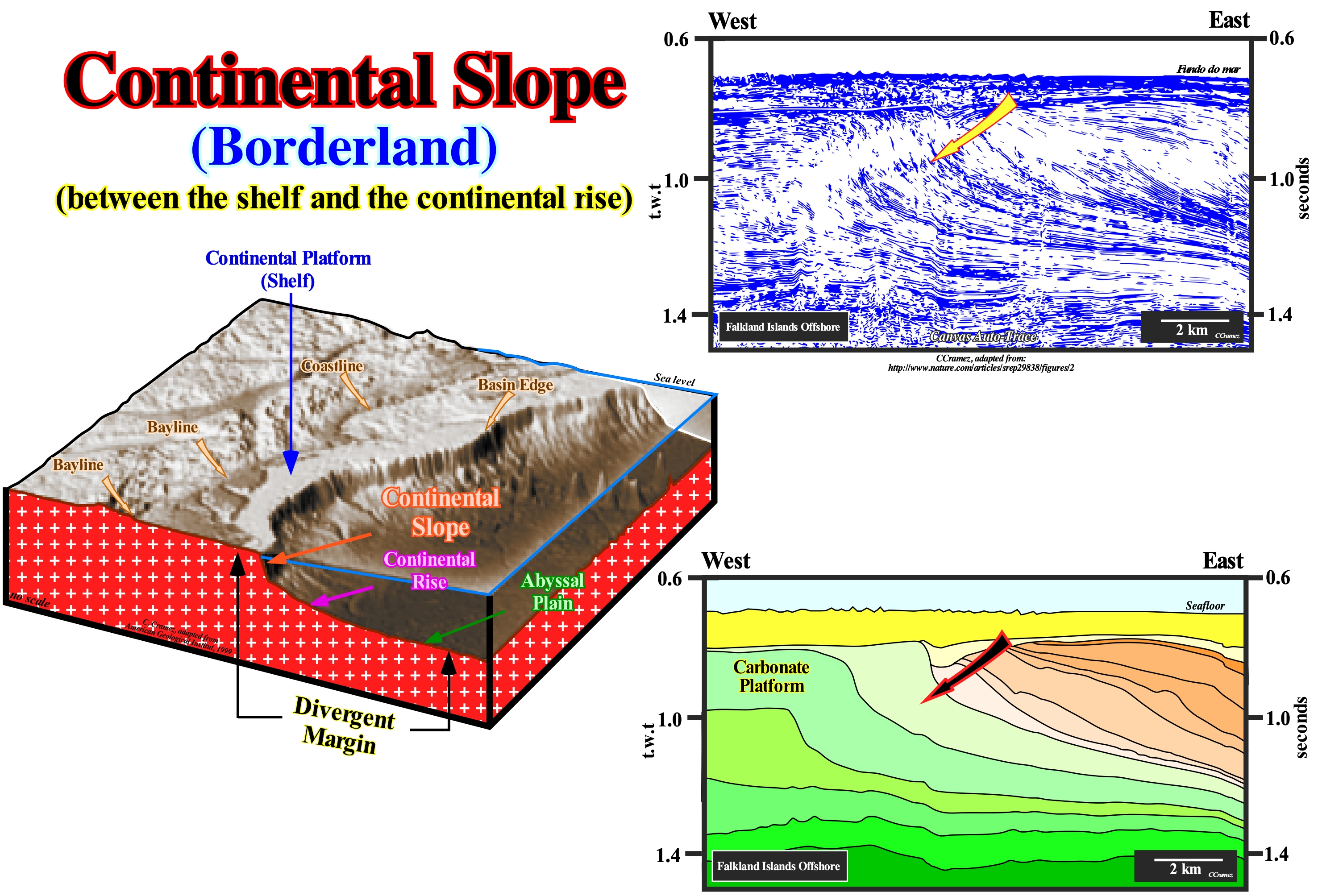
In this block diagram of a divergent continental margin, illustrated in this figure, it is easy to recognize the breaks (dip changes) of the deposition surface, which delimit the main sedimentary environments. From the continent seaward, we recognize: (i) The bayline, which separates the coastal plain from the alluvial plain, i.e., the line that limits, downstream, the fluvial from the paralic deposits (located near the coast and that have marine and continental features) ; (ii) The coastline, which limits the coastal plain of the continental shelf (separates the paralic from shallow water sedimentation) ; (iii) The basin edge, which in this case corresponds to the continental edge, since the basin has a platform, and marks the searward limit of the continental shelf (when, at the level of a sequential-cycle, a basin has no continental shelf, the basin edge is located upstream of the continental edge and is, in general, the last continental edge of the preceding sequence-cycle) ; (iv) The break at the base of the continental slope, which separates the continental slope from the continental rise and (v) The break of the base of the continental rise corresponding, more or less, to the continentward limit of the abyssal plain. The concept of bayline advanced by Posamentier and Vail, 1988 is still subject to controversy. It is based on conjecture that delta deposition occurs when a stream encounters a water-body, almost immobile, and its velocity decreases almost instantly, with which many geoscientists do not agree. In fact, Posamentier considers that: (i) The coastal plain is formed by progradation processes of sea-floor, rather than exhumation ; (ii) The sediments that accumulate in the coastal plain during the development of the coastline are part of the coastal wedge, which includes river and shallow water deposits ; (iii) The coastal wedge or coastal prism is wedge-shaped and extends continentward by onlapping over the pre-existing topography. Thus, it can be said that the bayline is the upstream limit of the coastal wedge, which can move upstream when the progradation of the shoreline is accompanied by aggradation and that it is the boundary between the coastal plain and the alluvial plain. Upstream of the bayline, relative sea level changes have do not influence the depositional systems. When, within a sequence-cycle, the shoreline coincides with the continental edge, the basin has no platform (no shelf). These geological conditions occur during regressive episodes, particularly, in lowstand geological conditions (when sea level is lower than the basin edge). In highstand geological conditions, during the second phase of development of highstand prograding wedge (HPW), the basin has no continental shelf (in this particular case the continental edge is also the basin edge). This is perfectly visible on the Canvas auto-trace of a detail of a seismic line from the Falkland Islands offshore, illustrated in the upper right part of this figure, in which continental slopes are predominant in the western part of the auto-trace, where they are, progressively, built by the sigmoid and oblique clinoforms (progradations) that move seaward the continental edge, which happens, when the basin, globally, has no shelf. The displacement of the continental edge was, several times, interrupted by significant relative sea level falls, which created erosional surfaces (unconformities) individualizing the various sedimentary packages recognized on this tentative interpretation that probably correspond to continental encroachment subcycles and not to sequence-cycles. A continental slope has, always, a height of more than 200 meters, so it can not be confused with a delta slope, which exceeds, rarely, 60 meters in height. However, when a deltaic building develops, i.e., when several deltas stacking, more or less, vertically, as in the Niger or Amazonas delta buildings, whose overall height can reach several thousands of meters, the continental slope can be considered as an stacking of delta slopes.
Bottomset (Chronostratigraphic line).........................................................................................Segment horizontal inférieur
Segmento horizontal inferior / Segmento horizontal inferior (línea cronostratigráfica) / Unteren horizontalen Segment / 底部的沉积段 / Придонный дельтовый слой / Segmento orizzontale inferiori /
One of the three segments that form a chronostratigraphic line: (i) Upper Horizontal Segment ; (ii) Seaward Dipping Segment and (iii) Lower Horizontal Segment. The lower horizontal segment (bottomset) represents, generally, sediments deposited in deep-water.
See: « Parallel Configuration »
Bottomset Bed..............................................................................................................................................................................................Couche de base
Camada Basal (de um delta)/ Estrato basal / Bondenschichten / 底积床 / Базальный слой / Strato basale (delta) /
Bed or group of sub-horizontal beds downstream, but in the natural continuation, of the deltaic slope (inclined layers or prodelta). Intercalated in the lower beds of a delta are, sometimes, sand lobes of turbidite origin (proximal turbidites). Sometimes called the Lower Beds of a Delta.
See: « Delta »
&
« Foreset Bed (of a delta) »
&
« Topset Bed (of a delta) »
As illustrated in the geological scheme of this figure, the thickness of a delta varies more or less between 10 and 60 meters. When certain people, even certain geoscientists, say, for example, that the Niger Delta is over 4,000 meters thick, they are confusing a delta with a deltaic building. It is the same as confusing the height of an apartment (delta), generally, about 2.40 meters high, with the total height of the building (delta building). A delta is a sedimentary systems tract (lateral association of depositional systems, i.e., of lithologies with a fauna, more or less, characteristic, synchronous and genetically associated) formed by three depositional systems, that is to say, that if a system disappears, usually, the other two also disappear. From the upstream, the depositional systems that make up a delta are: (i) Siltites, sands and clay rocks of the delta plain and the delta front sands ; (ii) Shaly rocks and very clayey sediments of the prodelta and (iii) Shales and, in certain particular cases, sands (proximal turbidites) at the base of the delta slope, i.e., on the base of the prodelta. All this means that in a delta, the chronostratigraphic lines have, in general, a sigmoid geometry. The sediments of the delta plain are deposited in the upper subhorizontal sector (upstream of the delta slope) and are often referred to as upper delta layers or upper beds. The sediments of the delta front deposited near the depositional coastal break, practically, on top of the delta slope are considered as forming part of the upper layers. The sediments of the prodelta deposit in the dipping beds (looking seaward), that is, in the delta slope, and are sometimes referred to as sloping layers of the delta (dipping beds). The distal sediments of the prodelta and the proximal turbidites deposit in the lower sub-horizontal sector (downstream of the dipping beds) are considered as lower layers of the delta. As a delta is a progradational sedimentary body, which deposits during the stability period of the relative sea level occurring after a marine ingression (displacement continentward* of the shoreline which is, more or less, coincident with the depositional coastal break coastal) the lower layers are very rich in clay and, generally, correspond to a vertical succession shales. As said before, sandy horizons of turbidite origin (Shell's distal turbidites) may be intercalated within the lower shaly beds, every time the delta front collapses due to an excessive slope increasing (when the critical angle, which is a function of the water-depth, is reached, the delta can no longer prograde seaward). A progradational geometry (when the depositional coastal break moves seaward and upward) implies a upward-coarsening and thickening succession. In general, in a delta depositional surface, three segments can be seen: (i) Upper horizontal segment (upper beds) ; (ii) Inclined segment (dipping beds) and (iii) Lower horizontal segment (lower beds). According to Walther's law, in continuity of sedimentation, these three segments succeed not only laterally (i, ii, iii), but also vertically (iii, ii, i). What is, usually, called the basal layer of a delta corresponds to the set of rocks that form the lower segment (iii), which as shown in the absence of proximal turbidites corresponds to a set of compact shaly rocks with levels of siderite (mineral composed of iron carbonate FeCO3 with traces of Mg, Mn, Ca, Co, Zn), fossils and bioturbation (process of construction of sedimentary structures of biological origin, such as crab holes, which are characteristic of specific environments, disturbing the sedimentary structure to which they overlap).
(*) Whenever the water-depth of a shelf is lower than the seismic resolution, it is evident that the geoscientist in charge of the interpretation of seismic data, naturally, considers that the basin has no shelf, that is to say, that the coastline, the depositional coastal break and the continental edge are coincident. Moreover, it is not possible to speak of the basin edge, since there is no shelf, it is the continental edge that serves as basin edge.
Boudinage..............................................................................................................................................................................................................................Boudinage
Boudinage / Boudinage / Boudinage / 石香肠构造 / Разлинзование / Boudinage /
A geological structure formed by extension (lengthening), in which a rigid tabular body, such as a sandstone layer, is stretched and deformed in the middle of less competent sediments. The most competent layer is broken, in such a way that in a vertical plane, the geometry is similar to an alignment of sausages and that in a horizontal plane, sometimes, its geometry is similar to that of a chocolate bar (C. E. Wegmann, 1932).
See: « Sandstone »
&
« Compaction »
&
« Slate »
The term boudinage was introduced in geology by Lohest in 1909. Lohest used it to designate the structures of a fractured horizon located between granite or schistous non-fractured rocks, since they reminded him of sausages ("boudin" in French). Each fragment of the (more competent) fractured rock resembles a sausage and the set of more or less separate fragments in a vertical section resembles a chain of sausages. As suggested by the photograph illustrated in this figure, boudinage was then found in almost all types of rocks, although the mechanism and the causes of development of these structures vary with the type of rock. More, generally, the term boudinage is now used in geology to refer to structures formed by an extensive tectonic regime, most often local, in a competent layer (sandstone, limestone, etc.) when it is sandwiched between two horizons or layers. The most competent horizon is stretched (traction) forming, more or less, cylindrical structures, as shown in the upper diagram of this figure. These cylindrical structures, which certain geoscientists call sausages or sausages, are characteristic of shear zones where, due to the extension (lengthening) along the sedimentary interfaces and the perpendicular shortening, the rigid horizons are broken. This type of structures can, also, be formed under conditions of ductile deformation. In three dimensions, as shown above, boudinage, function of direction and isotropy of extension, can be presented in two forms: (A) In sausage, as a lateral association of cylindrical fragments and (B) In chocolate bars, as a collection of more or less rectangular fragments.
Boulder..............................................................................................................................................................................................................................Bloc Erratique
Bloco errático / Bloque errático / blockieren Sie erratische / 阻止不稳定 / Эрратический блок (останец тектонического покрова) / Masso erratico /
Rock or grain size awith a diameter higher than 256 mm. The city of Boulder, in Colorado (USA), was thus called due to the large number of boulders that were found there. Huge blocks are deposited during the melting of the glaciers, since glaciers have, practically, an unlimited competence. As the boulders, which were transported by the glaciers, do not translate the lithology of the regions in which they are found, it is common to call them "erratic blocks".
See: " Granulometry "
&
“ Glacier ”
&
“ Erosion ”
The photograph in the centre of this figure illustrates a large granitic block fractured on Ffionphor beach in northern Scotland. Of course, this block is not an erratic block, since, as can be seen in the photograph, its granite lithology corresponds to that of the rocks that appear on the coastline. Although certain blocks can be moved manually, it is common to restrict the term block for those whose dimensions are so large that a person can not move them. An erratic block, as illustrated in the upper right figure, designates a piece of rock that has fallen from the surface of a glacier or has been torn from the ground by ice from a glacier and transported down the slope to the fluvio-glacial valleys. The erratic blocks corroborate the conjecture advanced by many geoscientists, that the fluvio-glacial valleys, as in the foreland of the Alps, have been, in the past, covered by glaciers. In the region of Lucerne (Switzerland), for instance, the erratic blocks are very large (some weigh more than 5 tons), which leads one to think (it is the opinion of most Swiss geoscientists) that the thickness of the ice of 1,000 meters. The idea of associating the erratic blocks with the glaciers was first invoked by a Swiss minister Bernard Kuhn (1787), but it was not welcomed by the scientific community of the time that continued to associate the erratic blocks with the Flood. It was only much later, in July 1837, during the meeting of the Geological Society of Neuchâtel (Switzerland), i.e., half a century later, that another Swiss Louis Agassiz (President of the Society), having adopted the ideas Jean de Charpentier*, also of Swiss nationality, convinced the international scientific community that erratic blocks had been transported by glaciers, which was the first stage of his theory on ice ages.
(*) According to Jean de Charpentier (1786-1855), in the eighteenth century, many of the inhabitants of the Alpine valleys associated the slickensides of rocks observed on the slopes of the valleys with glacial erosion. Such conjecture defended, orally, by Jean-Pierre Perraudin (1767-1858) in 1815 was, largely. accepted following the catastrophe that occurred in the valley of Bagnes in association with the Giétroz glacier. This glacier which was, already, known due to the rupture of an ice pack, which in May 1595 destroyed more than 500 houses and killed 140 people, created a natural dam following a landslide in the spring of 1818. The blocs of ice blocked the waters of the Dranse River, creating a lake about 60 meters deep and 3.5 kilometers long. Although in May 1818, cantonal engineer Ignaz Venetz ordered the excavation of a trench that allowed the evacuation of almost two-thirds of the volume of water retained by the lake, the summer heat weakened the ice dam, which ceded under the pressure of water on June 16, 1818, destroying hundreds of dwellings in the valley and killing 44 people.
Brackish Transgression (Gulf of Mexico)........................................................................Transgression Saumâtre
Transgressão Salobra / Transgresión salobre / Brackwasser Übertretung (Golf von Mexiko) / 咸水侵(墨西哥湾)/ Слабоминерализованная трансгрессия (Мексиканский залив) / Trasgressione salmastra (Golfo del Messico) /
Synonym of brackish ingression, when in the Gulf of Mexico, during the recent sedimentation processes (from 5,000 / 7,000 years ago), lakes, bays and lagoons covered the alluvial sediments of the deltaic plain (see Marine Transgression).
See: « Finger Delta, Digitated Delta »
Brackish Water..................................................................................................................................................................................................Saumâtre (Eau)
Salobra (água) / Salobre / Brackwasser / 咸水 / Горьковато-солёная вода / Acqua salmastra /
Water with an intermediate salinity between sea-water, normal and fresh-water.
See: « Juvenile Water »
&
« Depositional Environment »
&
« Hydrology »
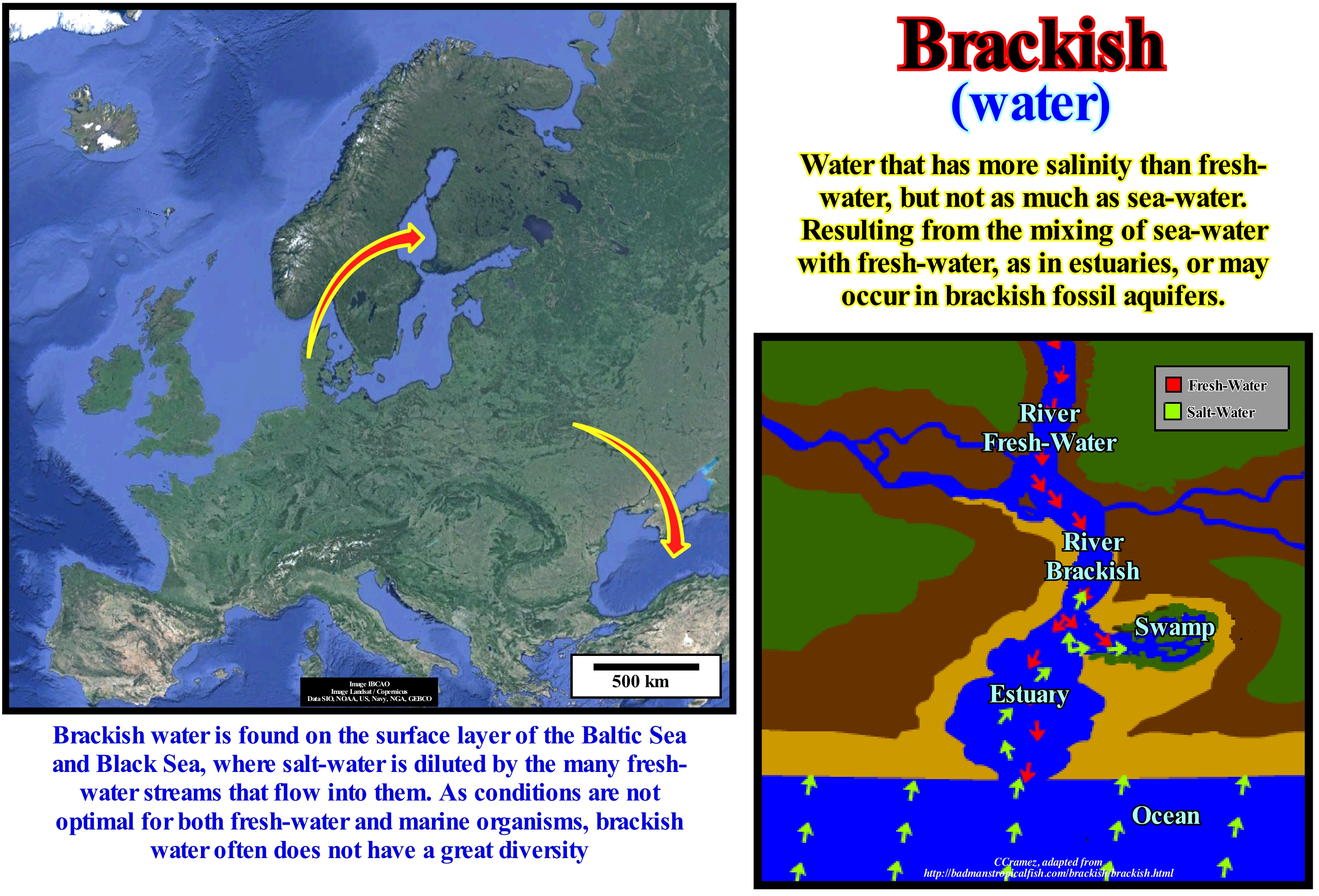
Water is said to be brackish when it has a poor salinity, which, in general, results from the contamination of the marine waters by fresh continental waters. Brackish waters are found near the mouths of rivers, lagoons or in the seas, more or less, closed and fed by the fresh- waters of the rivers or the melting of the ice of the glaciers. A brackish water is a mixture of sea-water with continental fresh-water. In an estuary, which is a water-body resulting from the combination of fresh-water and sea-water, the water is brackish. The estuaries, where rivers meet the sea, form very important brackish water environments where mangrove swamps develop very easily. That is why many mangrove swamps, though not all, embroider the estuaries and lagoons where salinity changes daily function of tidal currents. Certain lakes and seas may have brackish water. The Baltic Sea, illustrated in this figure, which communicates with the North Sea, is a sea with brackish water. Before the Pleistocene, the Baltic Sea did not exist. It corresponded to the confluence zone of the two great rivers. These rivers, even after the flooding of this area by the waters of the North Sea, as a result of the melting of the glaciers, continue to pour in the Baltic Sea a large quantity of fresh-water from the surrounding continental regions, so that the water of the Baltic Sea is brackish. Since salt water from the sea is denser than fresh-water coming from the continents, Baltic sea water stratifies, with salt-water in the bottom and fresh-water on the surface. This stratification is also, partly, due to the absence of significant tidal currents and storms. One of the consequences of the stratification of Baltic Sea water is the fauna. In this sea, fresh-water fish are frequent, close to sea level, while in the deeper parts, which are much saltier, fish in marine environments abound. Cod, for example, is only found in the deep-parts, while the cation is found on the surface at less salty levels.
Braided (Water-course)...................................................................................................................................................................................................En-Tresse
Anastomosado / Entrecruzado / Verwildert / 编织 / Многорусловая (разветвлённая) река / Anastomizzantisi /
River or water-course formed by a network of small channels separated by small temporary sandbars. The arms of the anastomosed or braided rivers have a, relatively, small depth and occur when the current has a strong slope and a great sedimentary load. This type of water-course is frequent in alluvial environments upstream of the bayline.
See: « River »
&
« Depositional Environment »
&
« Charge (stream) »
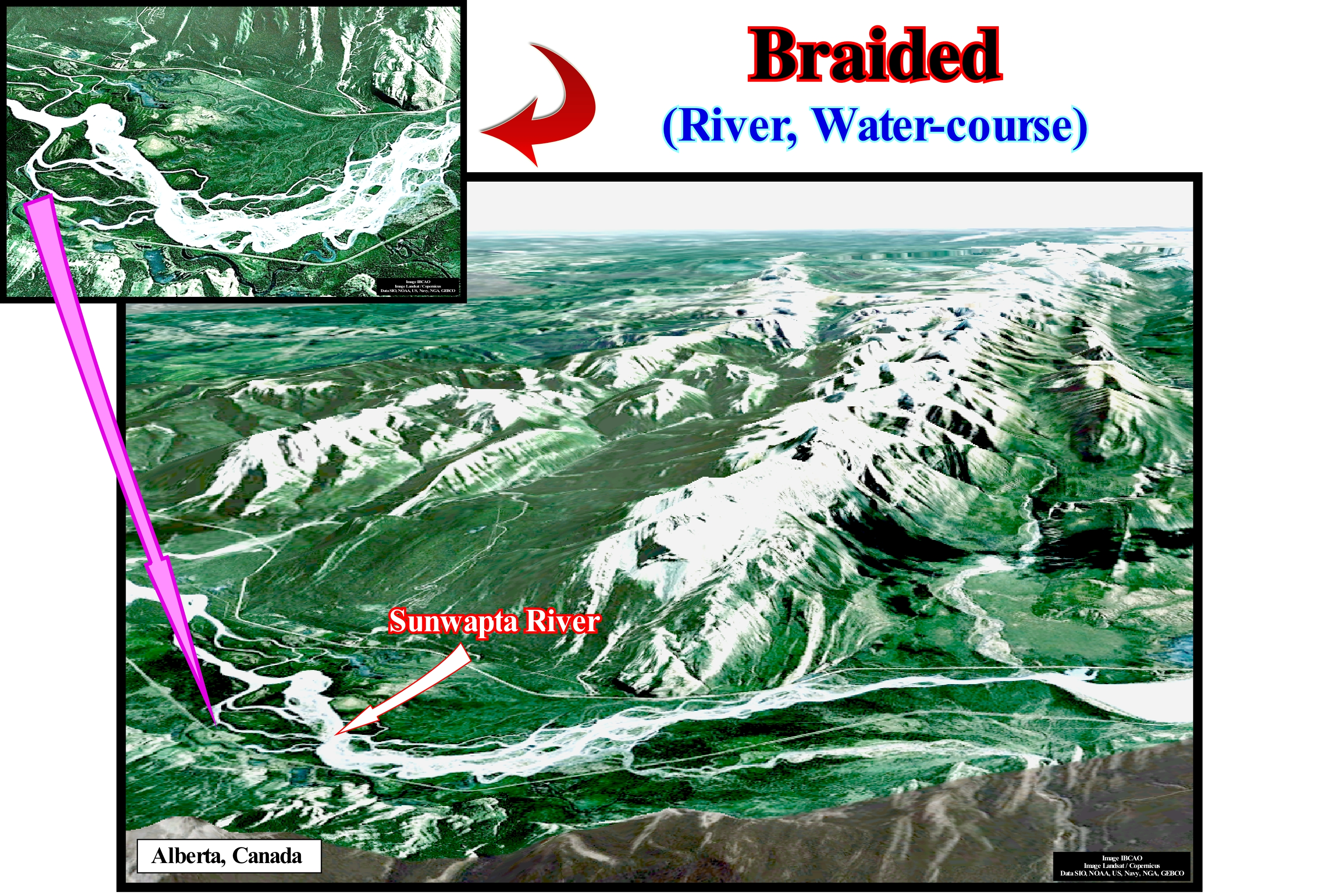
As shown in this figure, braided rivers or anastomosing river*, as certain geoscientists say, occur upstream of the bay-line, which corresponds to the slope rupture of a chronostratigraphic line delimiting alluvial (seaward) and fluvial deposits (continentward). In fact, along a chronostratigraphic line, which, by definition, underlines a depositional surface, there are several breaks (changes in dip). Seaward they are: (i) Bay-line break ; (ii) Depositional coastal break ; (iii) Delta break; (iv) Continental break and (v) Continental slope break (abyssal plain). The first break limits fluvial deposits, in which the influence of relative sea level changes are, practically, non-existent, from alluvial deposits (downstream), which are, partially, influenced by relative sea level changes. Do not forget that in sequential stratigraphy it is imperative to consider two types of sea level: (i) Absolute or Eustatic Sea Level, which is supposed to be global and referenced to the Earth's centre and (ii) Relative Sea Level that is local and referenced to the top of continental crust (bottom of sediments) or to the sea-floor. The absolute sea level is dependent on tectono-eustasy (controlled by the variation of the volume of the ocean basins), glacio-eustasy, which is controlled by the amount of ice, geoidal-eustasy (controlled by the distribution of ocean water caused by the variations of the terrestrial gravity field) and the thermal expansion of the oceans or steric sea level rise. The relative sea level is the result of the combination of the absolute sea level and tectonics (subsidence of the sea floor, when the predominant tectonic regime is extensional or uplift when the tectonic regime is compressional). The depositional coastal break corresponds, more or less, to the shoreline and so it can be said that it separates the marine deposits from the non-marine deposits. The delta break corresponds, more or less, to the boundary between the delta front sediments and the prodelta shales. The continental break corresponds to the shelf edge (shelf break), when the basin has a shelf (platform), or to the edge of the coastal plain when the basin has no shelf (lowstand geological geological conditions) and marks the passage of shallow-water deposits to deep-water deposits. The continental slope break marks the beginning of the abyssal plain. It is from this break that, within a sequence-cycle, the submarine fans (basin floor fans and slope fans) are deposited.
(*) An anastomosing river is composed of two or more interconnected channels that enclose flood-basins. This definition excludes, explicitly, the phenomenon of channel splitting by convex-up bar-like forms that characterize braided channels. In present definitions of anastomosing rivers, lateral stability of channels is, commonly, coupled with their multi-channel character. At the scale of channel belts, the terms 'straight', 'meandearing' and 'braided' apply, whereas at a larger scale, a river can be called anastomosing if it meets the definition given above.
Breaker (Surf)...................................................................................................................................................................................................................Déferlement
Quebra da Onda (rebentação) / Rompiente / Brandung / 冲浪 / Прибой / Onde che si infrangono /
Transformation of oscillation waves into translational waves, once, the depth of the sea becomes less than half of the wave-length. Also called Wave Surfing.
See: « Breaker, Surf, Breaking »
Breaking (Surf, breaker)................................................................................................................................................................Déferlement (De l’onde)
Rebentação (zona) / Rompiente / Brandung / 浪涌 (波浪) / Разрушающаяся волна / Mareggio, Rigetto, Cavalloni /
Transformation of oscillation waves into translational waves, once, the depth of the sea becomes less than half of the wave-length. Also called Breaker.
See: " Wave Base "
&
“ Beach ”
&
" Surf Zone "
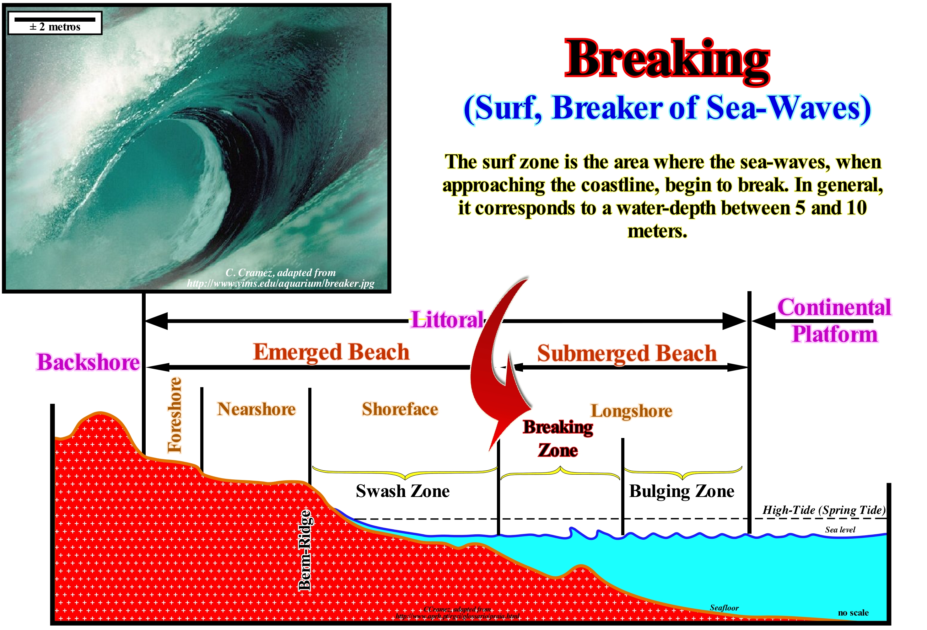
All mechanical waves, such as sound waves, the waves of a lake, the waves of the sea or the seismic waves, need a material medium to propagate. On the other hand, we all know that a mechanical wave does not carry matter, but only energy. However, in the sea-waves that propagate near the coast, this is in the zone of surf, this is not true. In fact, there are two types of sea-waves: (i) Oscillation waves, in the most distant areas of the beach, where water rises and falls (orbital motion, in which each particle of water describes an ellipse) ; and (ii) Translation or Breaking waves, near the coastline, where they loss velocity (decrease in wave-length), increase in amplitude and break (keeping the same frequency). When a wave approaches the coast, it becomes so abrupt that the water can no longer support itself and the wave breaks and falls into the surf zone (as illustrated in this geological scheme, landward of the zone of breaking, we find the swash zone and seaward the bulging zone*). The swashing zone is the area where the water moves to the mainland after the surf at a level higher than the mean sea level at that time. During this displacement, the remaining energy of the wave is converted from kinetic to potential. The upward movement of the water, whose direction is, strongly, influenced by the wind direction, transports sediments to the nearshore and shoreface, in a selective way, since as the flow loses energy, the sediments deposit function of their granulometry. The breaking of a wave corresponds to an increase of the curvature, with imbalance and collapse of the upper part of the crest of the wave. Indeed, since the energetic flux ** has to remain constant, the height of the wave (proportional to its energy) is progressively increasing. At very low water-depths, the velocity difference between the crest of the wave (where the depth is greatest) and the wave through (which propagates to the smaller depth) is significant and steadily increases, so that the wave crest advances over where there is no support and consequently, it breaks. The way a wave breaks depends mainly on two parameters: (a) Relation between the height and wave-length ; (b) Slope and roughness of the sea-floor. Three types of breaks are distinguished (Moreira, 1984): (i) Plunging Breaker, when the crest of the wave rises, it rounds, curling itself in volute, falling against its base (when the seafloor is inclined, regular and the ratio between the height and length of the wave is small) ; (ii) Spilling Breaker, when the crest of the wave becomes angular and breaks in the upper part, next to the apex, forming foam skeins, that slide in front of the wave (occurs when the bottoms are little inclined and whenever the ratio between the height and length of the wave is large) and (iii) Rolling Breaker, when the wave crest, rounded, increases the radius of curvature until it breaks in the upper or middle part, forming foam rollers (occurs when the bottoms are very steep and when the waves are very high and burst parallel to the shore to a large extent, as illustrated in this figure). When the seabed has a weak slope, the waves break away from the shore, whereas, when the sea-bed is, heavily, inclined, the waves break near the shore. When the back is rocky and the water of the deep sea, the waves blow, directly, on the rocks, with a force that can reach hundreds of tons per square meter, projecting the water into the air. It is therefore not surprising to find, along the coasts, cement walls (mole, pien, mound-dike) to protect the coast from the effects of waves and coastal currents. After the break in the surf zone, the waves, now much lower, continue to move and burst towards the coastline.
(*) The bulging zone is the zone where the waves interfere with the seabed and increase in height, since as they approach the beach. As the water-depth decreases, the propagation velocity also decreases, but as the energy flow is remained constant, the wave height increases progressively.
(**) Energy flux is the rate of energy transfer across a surface. The quantity is defined in two different ways, depending on the context: (i) Energy transfer rate per unit area ; this is a vector quantity, its components being determined in terms of the normal (perpendicular) direction to the measuring surface; sometimes called energy flux density, to distinguish it from the second definition; radioactive flow, heat flux, and sound energy flux are specific cases of energy flux density. (ii) Total rate of energy transfer, which is sometimes informally called energy current. (https://en.wikipedia.org/ wiki / Energy_flux)
Break-up of the Lithosphere (Wilson's cycle)..................................................Rupture de la lithosphère
Ruptura da litosfera / Ruptura de la litosfera / Aus der Lithosphäre / 岩石圈的分离 / Распадлитосферы, Порог (течение) / Rottura della litosfera /
One of the tectonostratigraphic phases of a Wilson's cycle: (i) Stable Continental Craton ; (2) Thermal Anomaly (hot spot) and Rifting Enlargement (lengthening) of the craton, with formation of rifte-type basins (usually half-grabens with opposite vergence on each side of the thermal anomaly) ; (3) Breakup of the lithosphere, with creation of new oceanic crust and formation of two divergent margins ; (4) Sea-floor Spreading (oceanic expansion, with progressively aging of the continental margins due to the cooling and increasing density of the oceanic crust) ; (5) Subduction, since the density of the oceanic crust is significant, it is divided in two parts and one of them enters in subduction (it submerges under the other one) creating a convergent margin, with formation of a volcanic arc and uplifting of a mountain range on the overriding lithospheric plate ; (6) Divergent Margin / Volcanic Arc Collision forming a mountain belt ( the twin divergent margin is at the other end) ; (7) Peneplantation of the Mountain Belt and new subduction of the oceanic crust with the twin margin creating another convergent margin ; (8) Continent / Continent Collision and closure of the ocean created between the two initial divergent margins and (9) End of the Wilson's Cycle with the formation of a new stable continental craton.
See: «Wilson's Cycle »
Break Unconformity.................................................................Discordance de rupture d’un supercontinente
Discordância BUU (ruptura de um supercontinente) / Discordancia de rutura de supercontinente / Breakup Diskordanz / 分解不符合, 差异打破了超大陆 / Распад несогласием, Расхождение преодолев суперконтинент / Discordanza di rottura di supercontinente /
Unconformity associated with breakup of a supercontinent. It is the upper boundary of the rift-type basins that lengthened the supercontinent prior to the break-up.
See: " Accretion "
Bright Spot (Seismic anomaly)............................................................................................................................................Anomalie sísmique
Anomalia Sísmica (bright spot) / Anomalía sísmica / Seismische Anomalie / 异常地震 / Сейсмическая аномалия ( аномалия типа "яркое пятно" ) / Anomalia sismica /
Strong and anomalous seismic reflection associated with lateral variations of the acoustic impedance. Sometimes, a bright spot can be induced by the presence of hydrocarbons in the reservoir-rocks. This kind of seismic anomaly appear in the seismic data because they are acquired and processed digitally (which preserves relative amplitudes) and not as a consequence or gain of the automatic control.
See: « Acoustical Impedance »
&
« Seismic Reflection »
&
« Diachronous (lithology) »
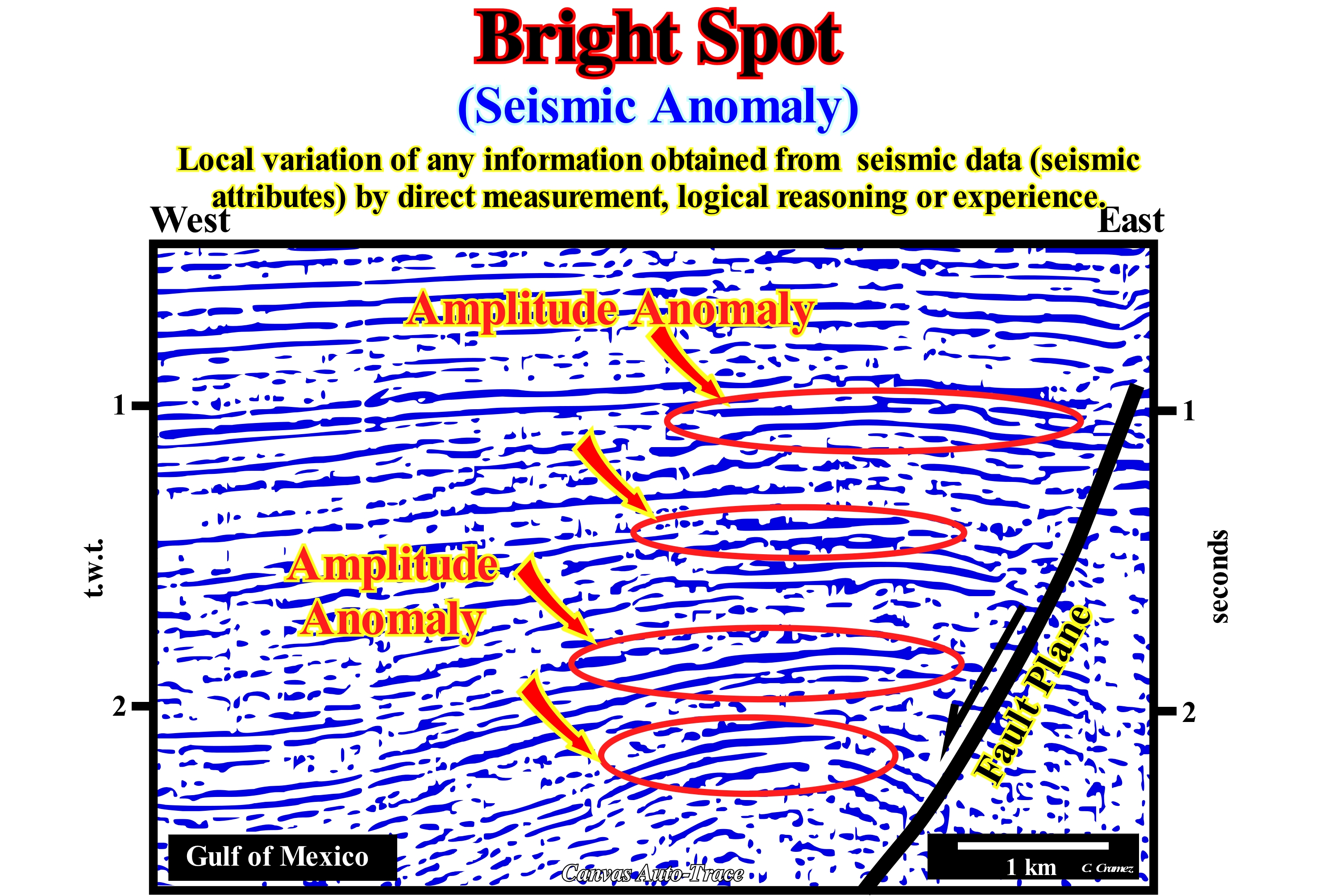
In this Canvas auto-trace of a Gulf of Mexico seismic line (Plio-Pleistocene), several seismic anomalies are identifiable in association with the top of an antiform structure (not to be confused with an anticline structure). An antiform is an extensional structure (lengthening) induced by an extensive tectonic regime (vertical σ1, i.e., the vertical maximum effective stress), whereas an anticline is a compressional structure resulting from the shortening of the sediments produced by a compressive tectonic regime (σ1 horizontal). In this auto-trace, the seismic anomalies are, probably, negative (change of polarity and amplitude due to the passage from an interval with greater impedance to another with smaller one) are induced by the presence of hydrocarbons (gas) trapped in an antiform trap. The tectonic structure, located in hangingwall (downward fault block) is an extensional structure. The sediments were lengthened by small normal faults (fault slip lower than seismic resolution), to respect Goguel's law, creating a non-structural trap (without self closure), which we call a morphological trap by juxtaposition*. In each potential reservoir horizon (in this example there are several), only the highest part, which is not affected by normal faulting, can be considered with a structural trap** with spill point, which corresponds to the intersection of the top of the reservoir-rock with the fault plane (note that normal faults, located at the top of the antiform are too small to be visible in the seismic lines). Apart from this small area, located in the highest trap part of each reservoir, the trap is non-structural. It is morphological by juxtaposition, which means that the reservoir-rock is closed vertically, but above all laterally (due to the fault movement) by an interval with a greater displacement pressure, that is, by a rock with characteristics of sealing-rock.
(*) In petroleum geology, petroleum traps can be (i) Structural, when they have their own closure, usually, associated with a sedimentary shortening and (ii) Non-structural. Among the non-structural traps different types can be recognized: a) Stratigraphic ; b) Morphological and c) Morphological by Juxtaposition. The latter correspond to what many geoscientists mistakenly call "traps against fault". In fact, a fault plane, which is an imaginary plane, which emphasizes the fracture zone, never prevents the hydrocarbons from moving laterally. What may, eventually, prevent hydrocarbons from lateral migration is the rock in juxtaposition to the reservoir-rock (in the opposing faulted block) if it has a higher displacement pressure.
(**) A structural trap is an unfaulted geological structure that plunges in all directions. Such geometry suggests that hydrocarbons under a horizon or impermeable layer (sealing-rock) may be trapped in a reservoir-rock of this structure. However, for this to happen it is necessary that the sealing-rock is, immediately, above the rock-reservoir and that they conform (without unconformity between them).
Brown Algae (Phaeophycea)......................................................................................................................................................................Algue Brune
Alga castanha / Alga castaña / Braunalgen / 褐藻 / Бурые водоросли / Alga marrone /
One of the constituents of the large group of marine algae. The brown algae (singular: alga), comprising the Phaeophyceae class, are a large group of multicellular algae including many seaweeds or macro-algae (several species of macroscopic, multicellular, marine algae) located in colder waters of the Northern Hemisphere. There are about 1,500 - 2,000 species of brown algae, some of which are of great commercial importance, such as Ascophyllum nodosum ("yellow tang" or "Knotentang" in German).
See: « Algae »
&
« Organic Matter (types) »
&
« Green-blue algae (Cyanobacteria) »
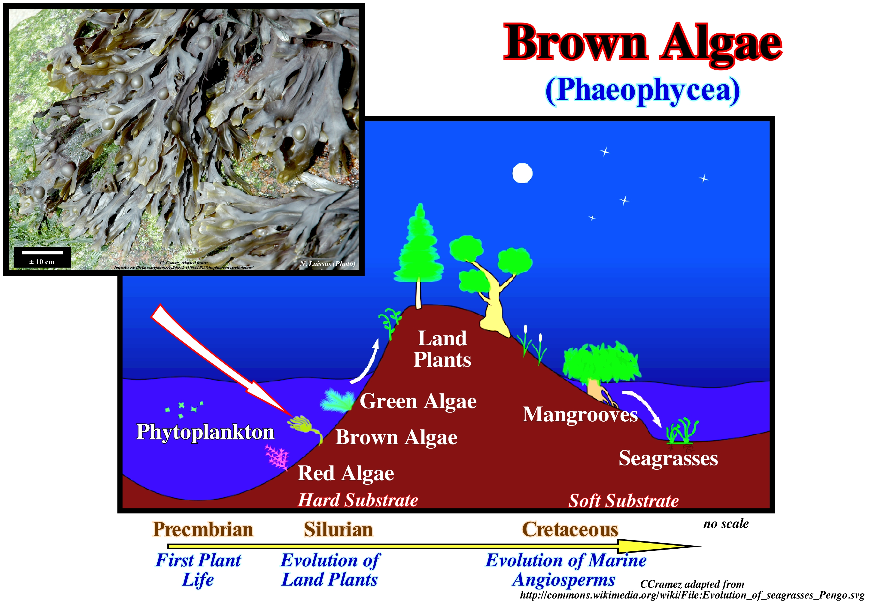
Brown algae are an important branch of algae, belonging to the large group of heterocontates, i.e., a group of eukaryotic or eukaryotic organisms (they have a true nucleus surrounded by a membrane with genetic material inside it) because they have chloroplasts (specific cells of the cytoplasm that lead to photosynthesis, since they contain chlorophyll* a & c surrounded by four membranes). This suggests that the group of the heterocontas** has a symbiotic origin between a primitive eukaryote and another eukaryotic organism. Many of the brown algae contain a pigment called phycoxanthin, which is responsible for the characteristic brown colour that most brown algae have. Brown algae are the only ones among heterocontates that originate multicellular forms with differentiated tissues, which reproduce by flagellated spores and gametes (a cell that fuses with another cell during fertilization, in organisms with sexual reproduction), that resemble other heteroconta cells. Brown algae or Phaeophyceas derived from the Phaeotaminiophyceas (species of the Chrisophyceas) between 150 and 200 million years ago. Some geoscientists think that the earliest fossils (Ediacaria) were brown algae that disappear over time. The lineages of brown algae, from the oldest to the most modern, are: (i) Dictyotales ; (ii) Esferacelariales ; (iii) Cutleriales ; (iv) Desmarestiales ; (v) Ectocarpals ; (vi) Laminarales and (vii) Fucales. Because of the limp of its body, the fossils of brown algae are rare, since only a few species deposit mineral salts around the wall of their cells. Do not forget that the dimensions of algae vary widely, ranging from the "vareque" or "sargaço" (multicellular algae), which can reach significant dimensions, to unicellular diatomaceas, which are the main components of the plankton. Some of the algae, such as certain stramenopilas, include Oomycetes, which are usually parasitic (Phytophthora, which attacks potatoes and Pithium that attacks the roots of plants), can be dangerous. As can be seen in the diagram shown on the left side of this figure, it can be said that the blue-green algae develop under a small blade of water and that as it increases the brown algae become preponderant to leave this preponderance the red algae under more important waterdepths. As indicated, the first plants appear during the Precambrian, the terrestrial plants during the Silurian and that the marine Angiosperms appeared during the Cretaceous.
(*) Group of photosynthetic pigments present in chloroplasts of plants. There are several types of chlorophyll. The chlorophyll of green plants has two forms, chlorophyll a, which is the main responsible of the green colour of plants and the realization of photosynthesis, and chlorophyll b. Chlorophylls are found mainly in algae and cyanobacteria. Chlorophyll a differs from chlorophyll b by having the -CH3 (methyl) radical in place of -CHO (aldehyde).
(**) The group of the Heterocontas or sub-kingdom Estramenopiles is monophyletic and covers the groups of oomicetas (they can exhibit from unicellular to filamentous, branched and cemetic forms that resemble the hyphae, which are characteristic of fungi, and for this reason, oomicetes were in the past, grouped together with them) and chrysophyceous algae (forming endogenous siliceous cysts that constitute a form of resistance), diatoms and browns, as well as other smaller groups. (http://www.criptogamas.ib.ufu.br/node/17)
Bucket (Carbonates, principle)..........................................................................................................................................Seau carbonaté (Principe)
Balde Carbonatado/ Balde carbonatado (principio) / Bucket-Carbonat (Prinzip) / 桶碳酸盐(原则) / Карбонатный ковш (принцип) / Secchio carbonato (principio) /
Growth architecture of a rimmed carbonate platform, with a geometry similar to that of an inverted bucket, since growth is, basically, determined by the potential growth of the rim.
See: « Reef Growth »
&
« Reef »
&
« Organic Production, Carbonate Function »
As shown in this figure, the growth architecture of a hardened carbonated platform resembles that of an inverted bucket or trunk with the mouth wider than the bottom. It is sustained either by rigid reef-like borders or by a rapid cementing of the shallow carbonate sands. It is filled by unconsolidated lagoon or tidal plain sediments. According to W. Schlager, three basic concepts have to be taken into account in carbonate sedimentation: (i) Carbonates are mainly of organic origin ; (ii) Carbonates build structures resistant to sea-waves and (iii) Carbonates undergo a very severe diagenetic change, since the original minerals are meta-stable. Each of these concepts has a number of important implications for carbonate registration, which are the result of an organic activity in a marine environment in which light and dissolved nutrients are available. Following the ideas of W. Schlager (1991), it can be said that: a) The higher the temperature the better, although there is a maximum limit for each group ; b) Tropical forms differ, greatly, from temperate forms ; (c) A strong concentration of small particles of organic matter damages carbonate-producing benthos (a community made up of organisms that inhabit the bottom of aquatic ecosystems and are distinguished from plankton and nekton, which are formed by organisms living in the water column) ; d) Very variable values of temperature and salinity reduce the diversity of carbonate producing benthos and, with extreme values, total carbonate production is, also, affected (restricted environments) ; (e) Carbonate production is maximal in the first 10-20 m of the water-slide but decreases, rapidly, downwards and upwards ; (f) Carbonate production is zero at the upper limit of the supra-tidal or splash zone (the area higher than the tide line and which is regularly sprinkled but not submerged by seawater, except during certain storms) and very weak in the aphotical environments or in the ocean ; g) Carbonate production follows the law of dynamic population growth (logistic curve) ; (h) Carbonated platforms die when carbonate-producing benthos are submerged beneath the photic zone, which occurs, sometimes, during relative in sea level rise. A set eustatic paracycles (marine ingression) that puts a carbonate platform under the photic zone underlines, according W. Schlager, an unconformity, whereas according to P. Vail it only underlines a ravinment surface. Vail considers that an unconformity is an erosional surface induced by a significant relative sea level fall that put the shoreline (depositional coastal break) lower than the basin edge. When the rain-water absorbs CO2 and attacks a limestone, it becomes HCO3 and Ca2 +, which means that CO2 is transferred from the atmosphere to the hydrosphere (CaCO3 + CO2 + H2O → 2 HCO3 - + Ca2 +). On the contrary, when the coral makes its exoskeleton, it removes 2 moles of HCO3- from the hydrosphere to form a mole of CaCO3 and a mole of CO2 that is used by symbiotic algae*, which means that CO2 will be, eventually, released into the atmosphere after the algae death. According to certain geoscientists (http://planet-terre.ens-lyon.fr/article /CO2-et-carbonates.xml) the precipitation/dissolution reactions of the carbonates, as described previously, are balanced in the short term, the which means that the balance is, practically, zero and that consequently they have no influence on the CO2 rate of the atmosphere. This suggests that variations in the geological scale of the CO2 rate in the atmosphere are, probably, associated with volcanism (which provides CO2) and weathering (which pumps CO2). Since the Earth's formation, about 4.5 Ga, surface carbonate development seems to have been slightly superior to deep destruction (by subduction and metamorphism), which probably contributes significantly to the decrease of CO2 atmospheric pressure during Phanerozoic (± 7,000 ppm during Cambrian, ± 367 ppm presently **).
(*) They associate with organisms of different species with mutual benefit.
(**) At present, the composition of the atmosphere consists of 78.1% Nitrogen, 21% Oxygen, about 0.9% Argon and traces of: (i) CO2 - 367 ppm ; (ii) Ne - 18 ppm ; (iii) He - 5 ppm ; (iv) CH4 - 1,8 ppm ; (vi) Kr - 1,1 ppm ; (vii) H2 - 0,5 ppm ; NO2, NO, N2O - 0,303 ppm ; (viii) CO- 0,1 ppm and (ix) Xe- 367 ppm (https://luispedro.wikispaces.com /file/view/Apresenta%C3%A7%C3%A3o+atmosfera.pdf)
Bypassing...............................................................................................................................................................................................Transit sédimentaire
Trânsito Sedimentar / Tránsito sedimentario / Umgehung / 绕过 / Осадочный переход / Scavalcamento /
Expression used for the first time by Eaton (1929) to designate a sedimentary transport through areas without deposit. Eaton used this expression for the displacement of a sedimentary particle that surpasses another, that is transported at the same time, or that continues its movement, whereas the first one has deposited. In sequential stratigraphy, sedimentary transit is used in a broader sense. It expresses, above all, the non-deposited areas traversed by sediments, especially during a relative sea level fall.
See: « Sequential Stratigraphy »
&
« Depositional Base Level »
&
" Turbidite "
In this model of Mutti (1993), in fluvio-turbidite systems, the bypassing (area without deposition crossed by sediments) is limited to the transfer zones of of the alluvial plain and upper part of the continental slope, where are initiated the turbiditic currents (gravity currents). In fluvio-deltaic systems, deposition takes place, above all, near the river mouths, where important delta buildings are formed. In fluvio-turbidite systems, the deposition takes place mainly in the deep parts of the basin, where the currents of turbidity lose speed and competence and, thus, deposit the sedimentary particles that they carry either in the form of submarine basin floor fans (SBFF) or in the form of submarine slope fans (SSF). For Posamentier and Vail (1988) deltaic deposition occurs when a current encounters a water-body, almost immobile and its velocity decreases nearly instantaneously. It was on the basis of this conjecture that they defined the bay-line, with which not all geoscientists agree: (i) The coastal plain is formed by processes of sea-floor progradation, rather than by exhumation ; (ii) The sediments that accumulate on the coastal plain during the progradation of the shoreline are part of what is called the "coastal wedge", which includes river and shallow-water deposits ; (iii) The coastal wedge or coastal prism has the shape of a wedge and extends continentward by onlapping over the pre-existing topography ; (iv) The upstream limit of the coastal wedge is the bay-line, which moves upstream when the seaward progradation of the shoreline is accompanied by aggradation ; (v) The bay-line is the limit between the coastal plain and the alluvial plain ; (vi) Upstream of the bay-line, relative sea level changes have no influence on depositional systems. As stated above, according to certain geoscientists, the encounter of a river with an almost immobile water-body that controls the (provisional) equilibrium profile occurs at the mouth of river, i.e., at the head of the deltas, and not at the bay-line as defined by Posamentier and Vail. From the point of view of sequential startigraphy, it is important to note that Mutti never denied the existence of submarine fans deposited at in lowstand geological conditions, as implied by Exxon's model (P. Vail, 1977). However, he admits and argues for the existence of submarine fans (on the basin or on the continental slope) deposited during highstand geological conditions, i.e., when, at the level of a sequence-cycle, the sea level is higher than the basin edge, which Vail has difficulty to admit. In highstand geological conditions, in particular, during the 2nd stage of development of the highstand prograding wedge (HPW), when the shoreline coincides, practically, with the continental edge (basin without platform), during large river floods. It is evident that large turbidity currents can be formed at the mouth of the great rivers which deposit submarine basin floor fans or submarine slope fans. On the other hand, instabilities and landslides on the continental edge that is, more or less, the shoreline (depositional coastal break) can cause debris flows and submarine deep-water fans. As illustrated in this figure, within a fluvio-delta system, downstream of the drainage basin or catchment area (the whole of the territory and of tributary rivers which drain the waters for that structural watercourse, which normally flows into the sea), seaward, the following deposition systems are recognized : (a) Alluvial Fans; (b) Braided or anastomosing Rivers (river without main channel, with the presence of several reliefs that lead the streams to divide and intertwine) ; (c) Rivers with Meanders (river that moves around the line of greater slope, passing alternately to the right and left of the axis around which it oscillates and (d) Mouth sand bars or wave delts (deltas of dimensions, relatively small, formed on the inner side of the opening of lagoons, bars and barriers, due to the accumulation of material transported by storm waves). Obviously interlocking rivers and meandering rivers are located in the transfer, which is limited downstream by the coastline. In a fluvio-turbidite system, after the alluvial fan, the transfer zone extends to the coast line, which passes downstream to the initiation zone of the marine gravitational currents, and then passes the deposit zone at the beginning of the abyssal plain where the submarine cones are deposited.
Bypassing Area (Clasts)................................................................................................................................................................Aire de transfert
Área de Transferência / Área de transferencia / Zwischenablage / 绕过面积 / Байпасирующая (обводная) зона / Area di trasferimento /
Zone without deposit along which the sedimentary particles are, usually, transported by gravity currents to the deeper areas of the basin. Sediment transfer zone or transit zones are frequent in both fluvio-deltaic and fluvio-turbidite systems.
See: « Sediment Influx »
&
« River-Delta System »
&
" Turbidite "
In this model of Mutti (1993), in fluvio-turbidite systems, the bypassing (area without deposition crossed by sediments) is limited to the transfer zones of of the alluvial plain and upper part of the continental slope, where are initiated the turbiditic currents (gravity currents). In fluvio-deltaic systems, deposition takes place, above all, near the river mouths, where important delta buildings are formed. In fluvio-turbidite systems, the deposition takes place mainly in the deep parts of the basin, where the currents of turbidity lose speed and competence and, thus, deposit the sedimentary particles that they carry either in the form of submarine basin floor fans (SBFF) or in the form of submarine slope fans (SSF). For Posamentier and Vail (1988) deltaic deposition occurs when a current encounters a water-body, almost immobile and its velocity decreases nearly instantaneously. It was on the basis of this conjecture that they defined the bay-line, with which not all geoscientists agree: (i) The coastal plain is formed by processes of sea-floor progradation, rather than by exhumation ; (ii) The sediments that accumulate on the coastal plain during the progradation of the shoreline are part of what is called the "coastal wedge", which includes river and shallow water deposits ; (iii) The coastal wedge or coastal prism has the shape of a wedge and extends continentward by onlapping over the pre-existing topography ; (iv) The upstream limit of the coastal wedge is the bay-line, which moves upstream when the seaward progradation of the shoreline is accompanied by aggradation ; (v) The bay-line is the limit between the coastal plain and the alluvial plain ; (vi) Upstream of the bay-line, relative sea level changes have no influence on depositional systems. As stated above, according to certain geoscientists, the encounter of a river with an almost immobile water-body that controls the (provisional) equilibrium profile occurs at the mouth of river, i.e., at the head of the deltas, and not at the bay-line as defined by Posamentier and Vail. From the point of view of sequential stratigraphy, it is important to note that Mutti never denied the existence of submarine fans deposited at in lowstand geological conditions, as implied by Exxon's model (P. Vail, 1977). However, he admits and argues for the existence of submarine fans (on the basin or on the continental slope) deposited during highstand geological conditions, i.e., when, at the level of a sequence-cycle, the sea level is higher than the basin edge, which Vail has difficulty to admit. In highstand geological conditions, in particular, during the 2nd stage of development of the highstand prograding wedge (HPW), when the shoreline coincides, practically, with the continental edge (basin without platform), during large river floods. It is evident that large turbidity currents can be formed at the mouth of the great rivers, which deposit submarine basin floor fans or submarine slope fans. On the other hand, instabilities and landslides on the continental edge that is, more or less, the shoreline (depositional coastal break) can cause debris flows and submarine deep-water fans. As illustrated in this figure, within a fluvio-delta system, downstream of the drainage basin or catchment area (the whole of the territory and of tributary rivers which drain the waters for that structural water-course, which flows, normally, into the sea), seaward, the following deposition systems are recognized : (a) Alluvial Fans ; (b) Braided or Anastomosing Rivers (river without main channel, with the presence of several reliefs that lead the streams to divide and intertwine) ; (c) Rivers with Meanders (river that moves around the line of greater slope, passing, alternately, to the right and left of the axis around which it oscillates and (d) Mouth sand bars or wave delta (deltas of dimensions, relatively small, formed on the inner side of the opening of lagoons, bars and barriers, due to the accumulation of material transported by storm waves). Fluvio-turbidite depositional systems explain, according to Emiliano Mutti, a large number of turbidite deposits, particularly those deposited during highstand geological conditions, which can not, easily, be explained by the model of Peter Vail. In fact, the EPR model (Exxon Exploration Production Research) or P. Vail model for deep turbidite deposits, as the vast majority of geoscientists say, assume that they are, directly or indirectly, associated with a significant relative sea level fall, which put the sea level lower than the basin edge* exhuming the shelf, if the basin had a platform, and the upper part of the continental slope.
(*) The term basin is used herein at the level of a sequence-cycle. Within a sequence-cycle, at the beginning of the deposition (lowstand systems tracts) the basin has no shelf. Then, during the deposition of the transgressive interval (TI) and the 1st phase of the highstand prograding wedge (HPW), the basin has a continental shelf. Finally, if the 2nd phase of development of the highstand prograding wedge was deposited, which is not always the case, the basin once again has a continental shelf. When a geoscientist says that the basin had a shelf, it is referring to the moment of deposition of the transgressive interval (TI) or the 1st phase of the highstand prograding wedge (HPW) of the considered sequence-cycle. Similarly, if he says that the basin has no shelf, he is referring to the time of deposition of the group of lowstand systems tracts or the 2nd phase of development of the highstand prograding wedge (if this if deposited) of a given sequence-cycle.

