
Hadal....................................................................................................................................................................................................................................................................Hadal
Hadal / Hadal / Hadal (Bathymetrie) / 超深渊(水深) / Глубоководный / Adale /
Area of the deep ocean environments, specifically, the oceanic trenches, that is to say, the zones with a waterdepth higher than 6,000 meters.
See: « Abyssal »
&
« Bathyal »
&
« Sedimentary Environment »
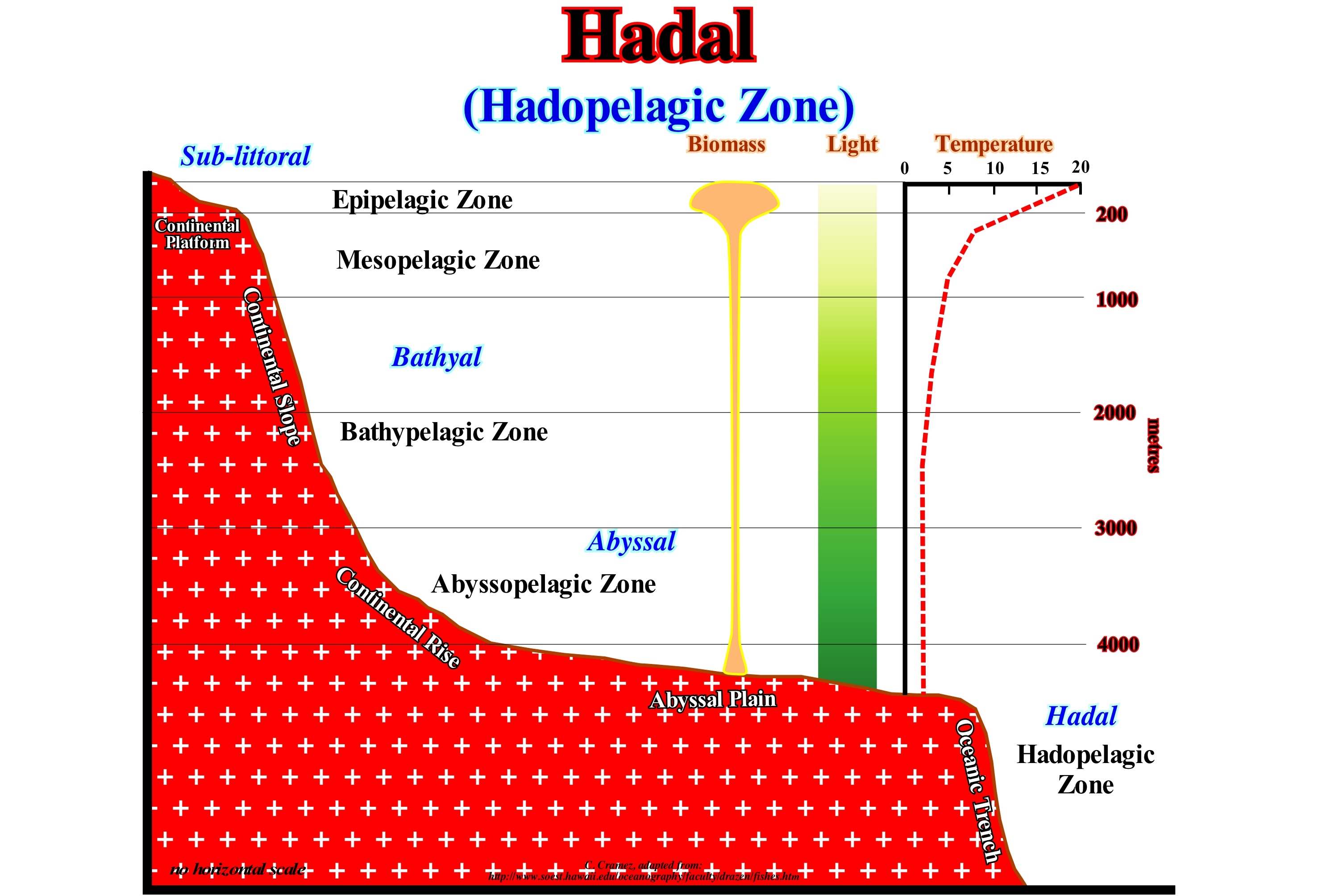
In this diagram, the epipelagic zone is the more familiar to the geoscientists. It is in these shallow waters, with lots of light, that phytoplankton, sardines, salmon, tuna and many other fish that we use in our food. Underneath this zone, which is, often, limited by a sharp drop in temperature (thermocline), lies the mesopelagic zone, where light still penetrates but is not strong enough to power photosynthesis. Most creatures living in the mesopelagic zone (deep-water community living in the shallowest part) have very fine eyesight to see in low light. In the bathypelagic zone there is no light. It has very low biomass (animal) and the temperature is very low. The border between the bathypelagic and abyssopelagic zone is not very clear. The abyssopelagic zone is considered as the water column that is, directly, above the continental rise and abyssal plain up to about 3,000 meters of water-depth. Certain geoscientists consider this region as part of the bathypelagic zone. In this diagram, we also have the hadalpelagic zone or hadal zone, that corresponds to the depths of the oceanic pits. Very little is known about this area, either with regard to the habitat or the creatures that live there. The benthic habitats are divided on the basis of the geology of the continental boundaries. Among the benthic habitats the most well-known is the sub-littoral zone, which is the shallow zone between the shoreline and the basin edge. Light penetrates, easily, into this environment, where a wide variety of corals, algae and fish live. The bathyal environment is the basis of the continental slope. It is, generally, little inclined and, often, dug by submarine canyons, sometimes, induced by significant relative sea level falls or initiated by upwelling currents. When the dip of the continental slope begins to decrease, it is the beginning of the continental rise, which finally passes into the habitat of abyssal plain benthic, where the submarine basin floor are deposited. The extreme benthic habitat corresponds to the oceanic trenches forming the hadal zone, whose maximum depth is 10,911 m.
Hadean.......................................................................................................................................................................................................................................................Hadéen
Hadeano / Hadeano / Hadaikum / 冥古宙 / Гадейский период / Adeano /
The oldest Eon in Earth's history. The Hadean extends from the origin of the Earth (± 4,5 Ga) until, approximately, 3,9 Ga.
See: « Geological Time »
&
« Eon »
&
« Geological Time Scale »
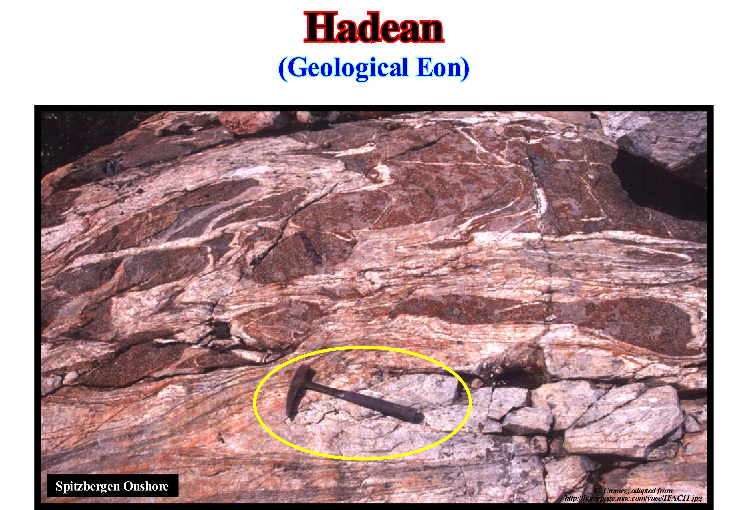
The rocks illustrated in this figure are, certainly, of the oldest of the Earth (Precambrian), but do not belong to the Hadean. This Eon, by definition can not be represented by rocks, as we define them today. In fact, the Hadean is the oldest geological Eon on Earth. Volcanic apparatuses were very abundant on the Earth's surface. Also, meteorites were very frequent and produced enormous scars of impact. Even today, some of them may be located, although, often, indirectly. Some geoscientists consider Hadean as the "zen" time period, once, it is defined by the absence of rocks. Its upper limit will always be receded each time older rocks are discovered. Practically, it can be said, that there are no fossils in Hadean time. Based on Earth's age estimations (February 2001), Hadean began around 4.56 Ga and ended around 4.03 Ga (taking into account the rocks) or about 4.40 Ga, taking into account the earliest crystals of zircon. Hadean is not yet a formal geological unit of the International Commission on Stratigraphy (ICS), since its definition, as said before, can not be documented and represented by rocks. Before the Hadean, the solar system (and its constituent bodies) coalesced from the matter of previous generations of supernovae. The Proto-Earth, i.e., the Earth in early stage of its development, was a combination of pieces of ice, rock, metal and viscous carbonaceous matter. During the Hadean, the Proto-Earth was differentiated in at least one metallic core and a rocky mantle. The heat for such a differentiation was, probably, created by the impact of meteorites, gravity and radioactive decomposition. On the basis of asteroid dating, this differentiation took place in some tens of millions of years. In the first 100 My after differentiation, the Proto-Earth collided with Theia (hypothetical planet with a size similar to the planet March). From this collision, a part of the mantle, stood out from the Proto-Earth and began to orbit (without water or other volatile elements). Some geoscientists think this is how the Earth's satellite, that is, the moon, was formed.
Hadley Cell s.l................................................................................................................................................................................Cellule de Hadley s.l.
Célula de Hadley / Célula de Hadley s.l. / Hadley-Zelle s.l. / 哈德利细胞 s.l. / Ячейка Гадлея s.l. / Hadley cell lato sensu /
Air circulation pattern, which predominates in the tropical atmosphere, with an upward movement, near the equator (flow towards the poles at about 10-15 km above sea level), and downward movement, in the sub-tropical regions, towards from the equator, near sea level. This air circulation is, closel,y linked to trade winds, tropical rain belts, sub-tropical deserts and jet streams.
See: " Atmosphere "
&
" Coriolis Effect "
&
" Climate "
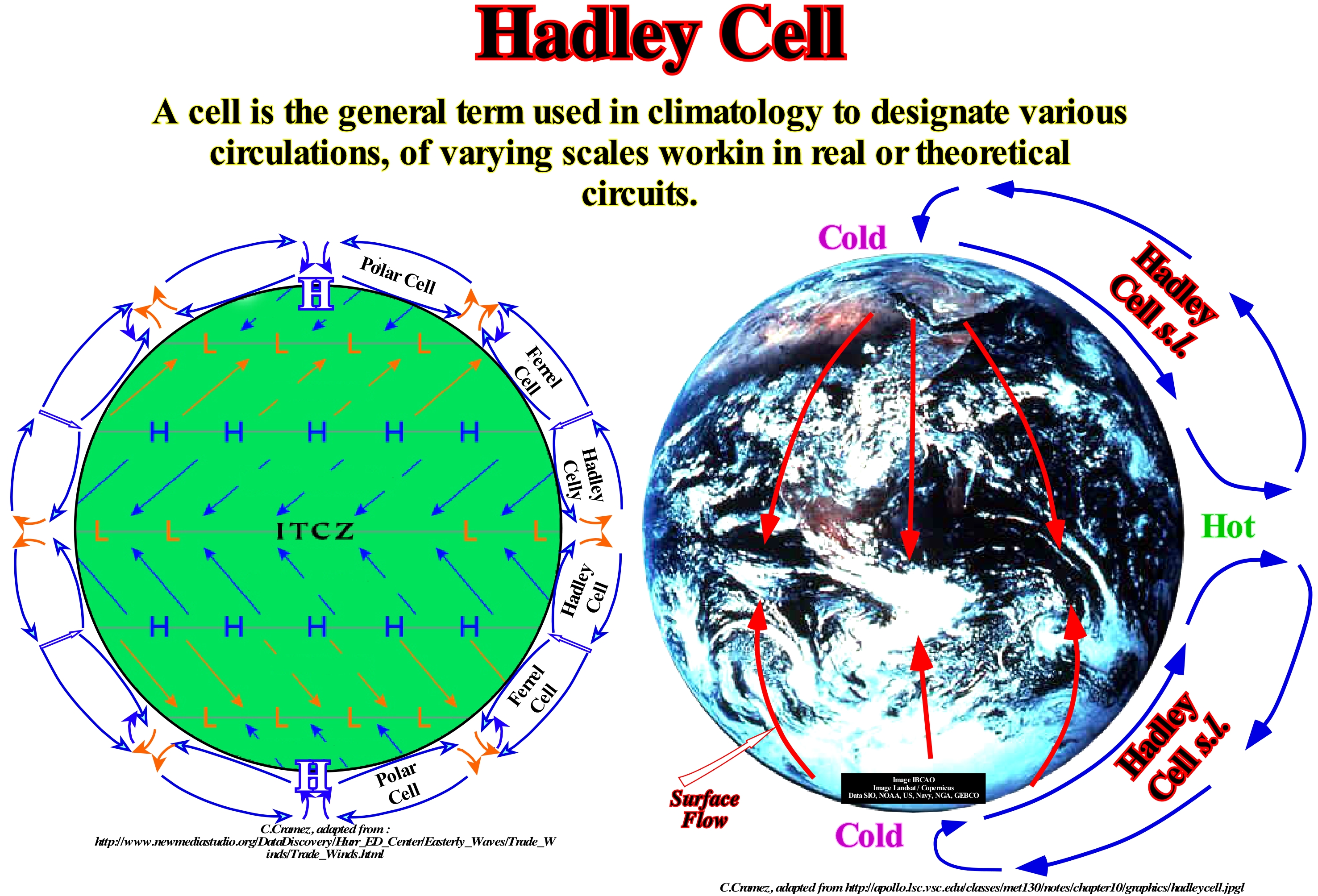
In this sketch are illustrated Hadley cells (lato sensu), i.e., air currents going from the equator to the poles and returning to the equator. In detail, the Earth is surrounded by several belts or prevailing wind cells, which are separated by narrow regions where the air moves down and up (descent and ascension). Many geoscientists consider a Hadley cell (equator - poles - equator) can be sub-divided into three secondary cells: (i) Hadley cell (strito sensu) ; (ii) Ferrel Cell and (iii) Polar Cell, with three types of trade winds: (a) Northeast; (b) West and (c) East Polar, to the northern hemisphere. Near the equator, where the average solar radiation is the strongest, the air is heated and begins to rise creating a low-pressure, centred in equator (ITCZ, Intertropical Convergence Zone). This zone, which begins to form in the sub-tropical regions, when it reaches the equator, it rises toward the upper atmosphere by convergence and convection. Since it reaches an altitude of about 14 km (top of the troposphere), it begins to flow, horizontally, towards the poles. The upward current corresponds to a circulation segment of the Hadley cell (strito sensu), which descends to the Earth's surface around 30° North and South. At these latitudes, the descending portion produces a high pressure air strip called subtropical high. From this zone, the air moves in two directions. As the air flows from the high to low pressure zone, the winds are generated between the subtropical high and the low pressure equatorial belt (ITCZ). These winds, as they travel towards the equator, are diverted from east to west by the Coriolis force. The other part of the air that moves from the subtropical high zone toward the poles is also deflected by the force of Coriolis, producing winds of the West.
(*) Coriolis force or Coriolis effect is a reference system in uniform rotation, in which moving bodies, when viewed by an observer in the same frame, appear to be subjected to a force perpendicular to the direction of its movement.
Haloclasty (Salt splitting).....................................................................................................................................................................................Haloclastie
Haloclastia / Haloclastia / Salzsprengung / 盐风化 / Расщепление соли / Sale splitting, Aloclastismo /
Process of mechanical fragmentation of the rocks due to the crystallization of salts from sea-spray* and sea-water. By evaporation of the salt water, which permeates the cracks of the rocks, the concentrated salt solution and the mineral salts increase in volume, which break-up the rocks.
See: « Sea-Spray »
&
« Halokinesis »
&
« Compensatory Subsidence »
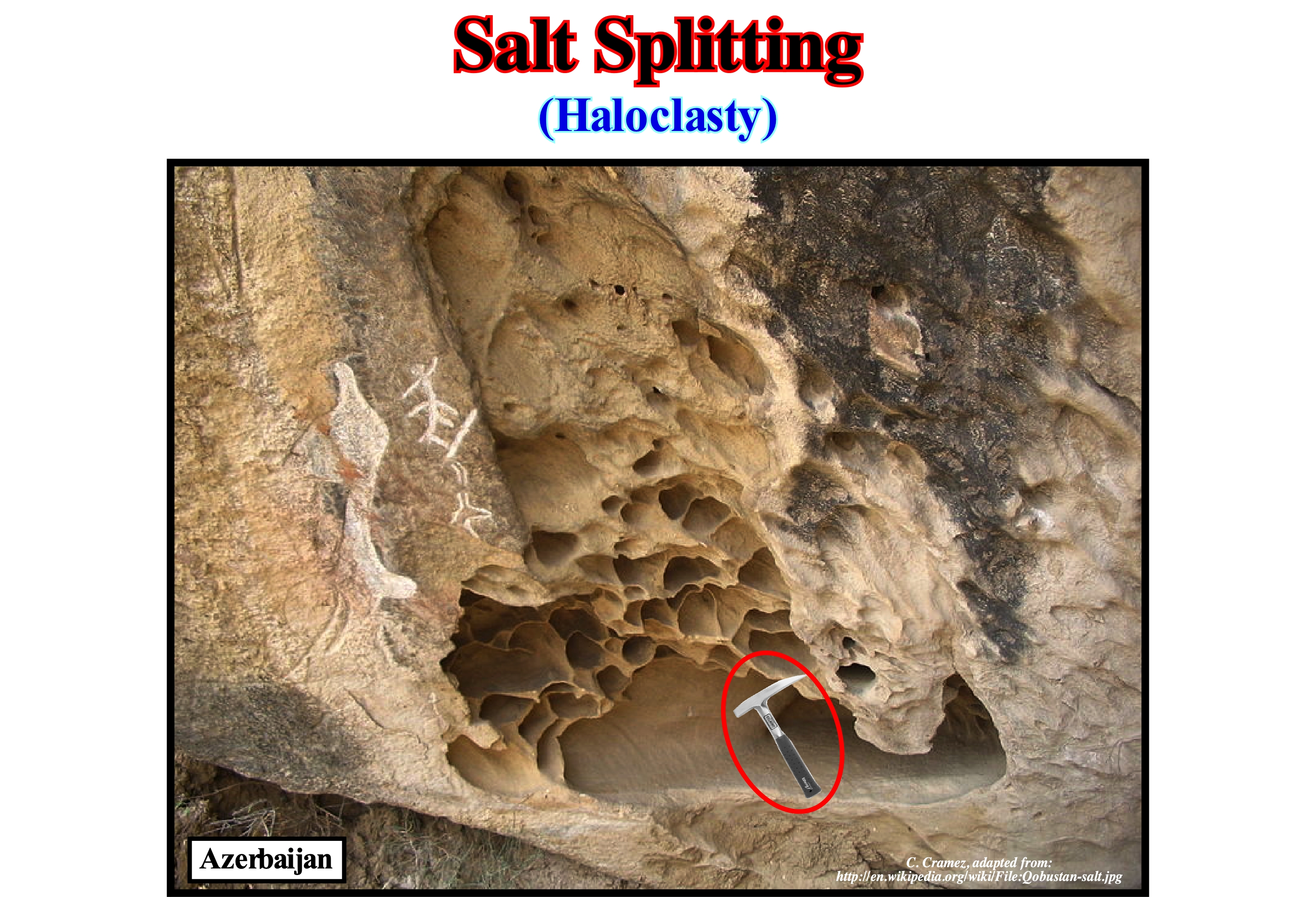
Haloclasty is often called salt splitting. However, what geoscientists call salt splitting has nothing to do with what the American authors call "salt splitting" in electrochemical weathering (when an electric current is applied to sea-water, which causes the separation of a solution, mainly hydrochloric acid, ClH, and a basic solution, especially sodium hydroxide, NaOH). Haloclasty is a type of physical weathering caused by the growth of salt crystals. The process is initiated when saline water enters fracture or fissures of the rocks and then evaporates leaving deposit of salt crystals. When the rocks are heated by the simple action of sunlight, the crystals increase in volume, which creates an important pressure on the rock, which with time, fractures into, more or less, large pieces. Salt crystallization can also occur when certain solutions break down rocks (such as limestone) to form saline solutions of sodium sulfate or sodium carbonate, which, if the moisture evaporates, deposit salt crystals. The most effective salts in disintegrating rocks are sodium sulfate, magnesium sulfate, and calcium chloride. Some of these salts can expand up to three times or more. Haloclasty is, usually, associated with arid climates, where the high temperature causes a strong evaporation and, therefore, the crystallization of the salt. As illustrated in this figure, haloclasty is, also, very common along the coasts in association with the sea-spray or salt-spray. The chemical weathering can be done by: (i) Solution ; (ii) Hydration ; (iii) Hydrolysis ; (iv) Oxidation ; (v) Sulfation (addition of sulfur dioxide to limestone produces gypsum - calcium sulphate - which is more soluble than calcium carbonate is easily dissolved and washed away by rain) and (vi) Biological processes. The most common weathering (a set of chemical, physical and biological phenomena that cause rocks and minerals to change) is the release of substances (such as acids) secreted by trees to disintegrate elements such as aluminium and iron in the surrounding soil.
(*) A foam cloud formed by droplets of sea water and bubbles enclosing saline microcrystals resulting from the breaking foam that is projected against the shore and transported inland by the wind. Salt spray is responsible for a characteristic corrosion modelling and the presence of certain biocenoses, that is, balanced associations of animals and plants in the same biotope (the physical environment where the living beings live in an ecosystem) and the formation of other (woody plants) (Moreira, 1984).
Halocline.........................................................................................................................................................................................................................................Halocline
Haloclina / Haloclina / Halokline / 盐跃层 / Галоклин (скачок солёности) / Halocline /
Zone of a stratified body of water in which the salinity varies, abruptly, in depth.
See: « Stratification (water) »
&
« Lake »
&
« Accommodation »
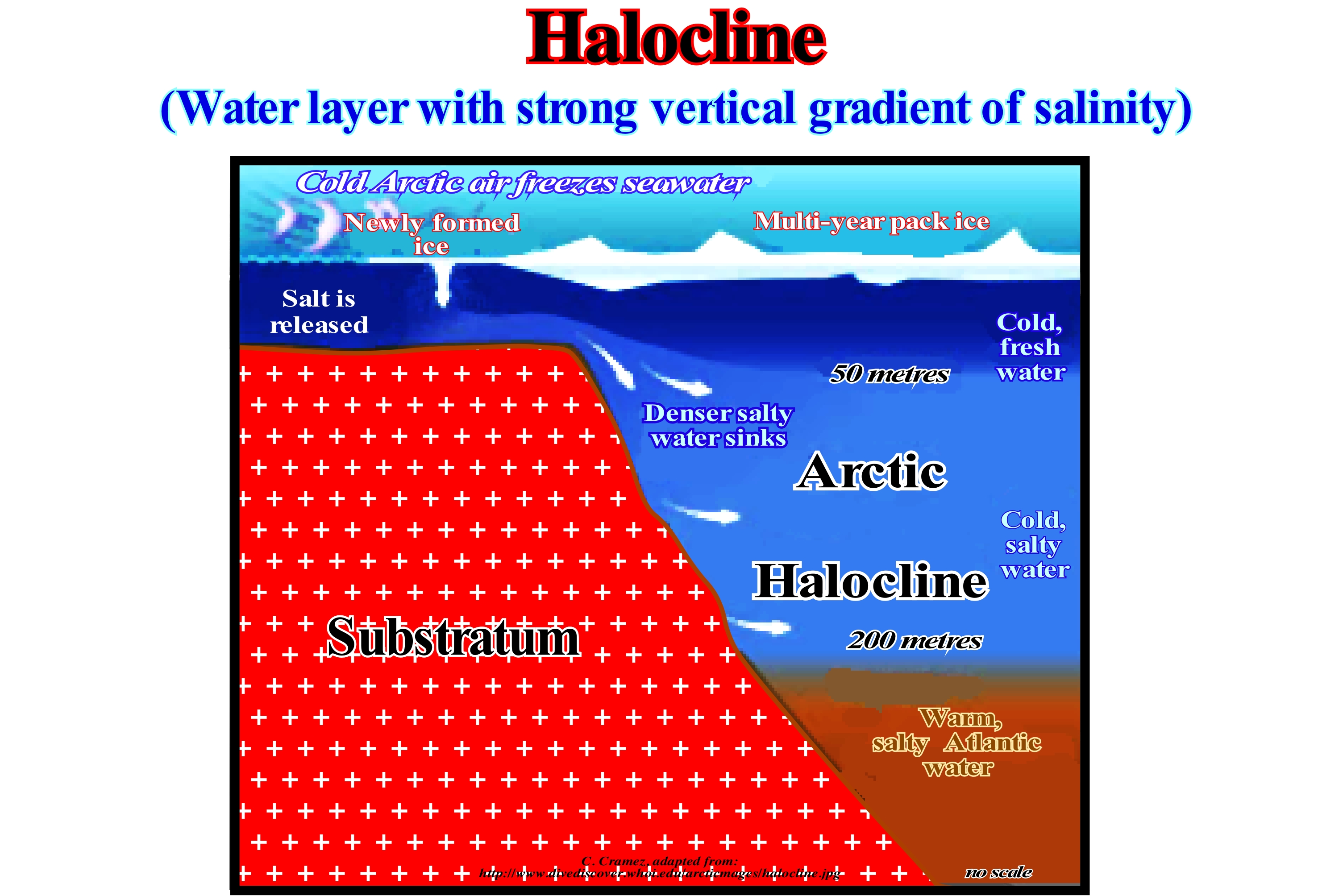
As shown in this sketch, the halocline is a strong vertical variation of the salinity of the water. An increase in salinity of seawater of 1 kg/m3 produces an increase in water density of about 0.7 kg/m3. It is the salinity that, in large part, controls the stratification of sea-water. A more salty water dives into a less salty one. This means saltier halocline are under the less salty ones. However, there is one important exception, which is illustrated in this figure, namely the Arctic Ocean halocline. It is colder and denser than the underlying warm water of the Atlantic. It may be said the Arctic halocline protects the melting of the polar cap induced by the Atlantic warm water. In the Arctic regions, when ice is formed from a, relatively, salty water, the salt is released and will contaminate the surrounding water making water surface much saltier and denser. These cold, salty, dense waters plunge beneath the less denser water below the ice cap (agglutinated blocks of ice) forming a halocline, i.e., a thick, cool, dense (salty) zone that acts as a barrier between the less salty and cold surface water and the deeper and warmer (less salty and less dense) Atlantic Ocean water. When the Atlantic water enters the Arctic through the Fram strait (passage from the Arctic Ocean to the Greenland Sea and the Norwegian Sea between Greenland and Siptzberg), it melts the ice, making the upper part of the Atlantic water less salty and more cold, which creates a lower halocline. In areas where evaporation is much more important than precipitation, i.e., in very hot regions, surface waters become saltier than deep waters destabilizing the halocline, since the stratification is inverted. Do not confuse halocline that is simply the region beneath the surface of a water-body where there is a significant increase or decrease in water density (due to salinity), with the thermocline that is the area within a water-body, which marks an abrupt increase in temperature.
Halohelophyte (Halohelophitic, organism)......................................................Halohelophyte, Halohelophytique
Halo-helófito / Halo-helófito / Halo-helophitisch, Geschöpf von Salz Schlämme / 生物的盐泥浆 / Халогелофит / Creatura di sale fanghi /
Organism that lives in a soil or salty environment, as, for instance, in marshes, mangroves, beaches, coastal dunes and sabkhas. In temperate regions, halohelophyte organisms inhabit the marshes and in tropical regions, they are common in mangroves. Synonym with Halophyte.
See: « Sabkha »
&
« Schorre »
&
« Soil »
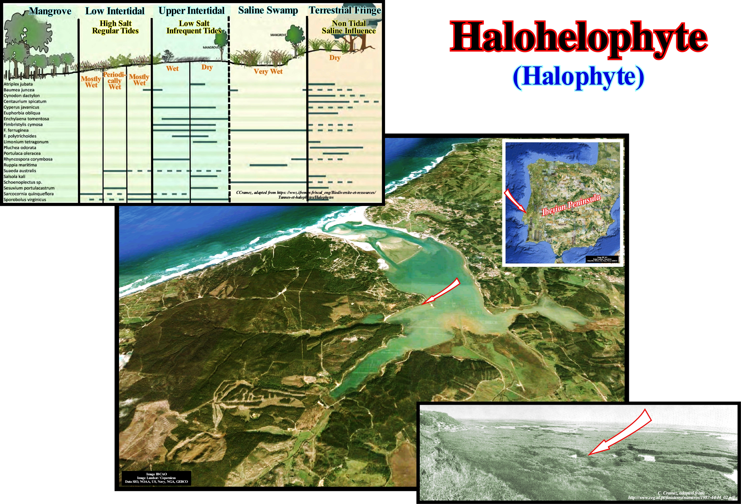
In botany, especially from the point of view of ecology, halophytes are called plants, which being, essentially, terrestrial, are adapted to live at or near the sea, since they are tolerant to salinity. Its tolerance can reach up to about 15 g of sodium chloride per litre, which is, roughly equivalent, to half of the concentration of sea-water. These plants absorb, for instance, sodium chloride at high rates and accumulate it in their leaves to establish an osmotic equilibrium with the low potential of water present in the soil. Halophytic plants live, often, in the mangroves. Some species of trees in this ecosystem have aerial roots that absorb oxygen from the air, for their respiration. Relatively few species of plants are halophyte (perhaps just 2% of all plant species). The vast majority of plant species are glycophytes, i.e., plants that are not, naturally, found in a saline substrate but tolerate, more or less, a certain amount of salt. They are, easily, damaged by the salinity of the water. The adaptation to saline environments by halophyte plants can be by salt tolerance (halotolerance) or by avoiding salt. Plants that avoid the effects of too much salt, despite living in a saline environment are called facultative halophyte plants, rather than true halophyte plants. A short-lived species that completes its breeding cycle during periods where the salt concentration is low (such as during the rainy season) avoids salt rather than tolerating it. Certain plant species may maintain an internal concentration of normal salt by excreting the excess salts through the leaves or through a concentration of salts in the leaves until they die and fall. In prehistoric times, the halophyte vegetation was burned to produce alkaline potash. Potassium and other foundries of the Chalcolithic period (4th century BC) were discovered in Tuleylat el-Ghassal, about 10 km northeast of the Dead Sea, suggesting an important settlement in this area. There is, relatively, little difference between a halophyte (living in an environment or saline soil, such as spits, mangroves, beaches and coastal dunes, desert areas of sabkha, etc.) and a halo-helophyte organism, which lives, preferably buried in the salty muds. Often, halo-helophytes live in marshes, estuaries and deltas where they form mudflats (a term given to alluvial formations periodically flooded by salt water and occupied by a halophyte vegetation or in some cases by salt crusts) or in mangroves intertropical ecosystems (coastal, transitional ecosystems between terrestrial and terrestrial and marine environments, i.e., a humid zone characteristic of tropical and subtropical regions). These organisms are, usually, aerobic microorganisms that live and grow in salt or salty environments. The salt content of a halophyte environment is, generally, 10 times that of sea-water, which corresponds, generally, to about 30%. Examples of environments where halophytes live include the Great Salt Lake of Utah, Lake Owens (California), the Dead Sea, etc. These organisms use osmotic pressure and chemicals such as sugars, alcohols, amino acids to help control the amount of salt in cells (osmotic pressure is the ratio of fluids inside and outside a cell). The healthy cells maintain the same pressure inside and outside the cells. These organisms are like other extremophiles. The proteins, inside them, play the most important role, allowing them to survive in a salty environment. These organisms are coated with a special protein layer, which allows only the entry into the cell of certain levels of saline solutions. Such a coating allows, by the diffusion process, the cell to maintain the salt content at an appropriate level, regardless of the weather.
Halohydromorphic (Sediment).......................................................................................................Halohydromorphe (Sédiment)
Halo-hydromorfo / Halohidromorfo (sedimento) / Halohydromorph, Sediment mit Sole / Halohydromorph (沙水与盐 ) / Осадок с соленой водой / Sedimenti con acqua salata /
Sediment, usually, a soil deposited in an engorged medium of saltwater periodically or permanently.
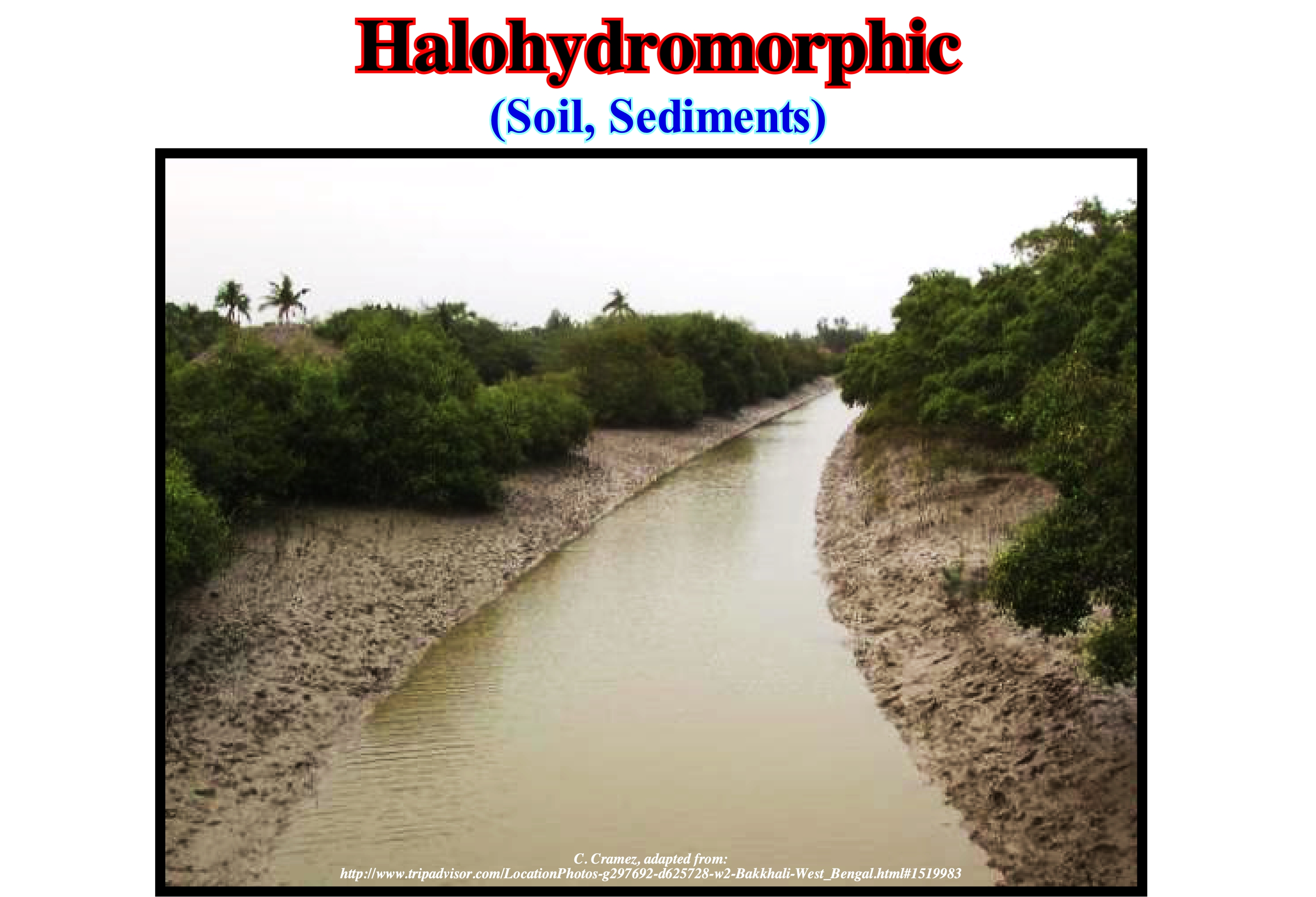
In the inter-tropical coastal area, the mangrove and halo-hydromorphic sediments associated, shown in this figure (Bakkhali, West Bengal), occupy the area, directly, subject to the influences of tide. They correspond to supra-littoral floors, inter-tidal and to the upper part of the infra-littoral floor system according to the zoning system, classically adopted in the marine environment. It is this area, with a salt content, more or less, variable and is, normally, colonized by Rhizophora mangle featuring the amphibious plant formation that Macnae (1968) called "mangrove", since it forms, generally, an specific ecosystem. Mangroves are ecosystems that comprise plant communities and animals typical of wetland environments, resistant to high salinity of the water and soil, colonizing the tropical and sub-tropical coasts of the Americas, Africa, Asia and Oceania. The plant species that constitute the mangrove are, physiologically, and morphologically adapted to the amphibian euryhaline (with a wide range of salt content), supporting high osmotic pressure (pressure that must exert about a solution to prevent the solvent of passing through a semi-permeable membrane), which are applied to aerial root and pneumatophores systems. Pneumatophoric roots, which are also known as respiratory roots, develop in wetlands, where the soil is, usually, very poor in oxygen. They are characterized by: (i) Starting from roots in the soil ; (ii) Grow vertically ; (iii) Emerge from the water and (iv) Having pores that allow the absorption of atmospheric oxygen. An animal that can survive in brackish water is euryhaline. An extremely euryhaline animal may be able to tolerate shorter or longer periods in freshwater. The term euryhaline is, also, used for fresh-water animals that can withstand considerable increases in the saline content of water without affecting their metabolism. A stenohaline organism, marine or freshwater, can withstand just a small variation in the saline concentration of the water where it lives. These animals use salinity regulation systems such as lachrymal glands, nasal cavities, etc.
Halokinesis (Salt tectonics)..............................................................................................................................................................................Halocinèse
Halocinese / Haloquinesis / Halokinese, Salztektonik / 盐构造 / Соляная тектоника / Tettonica del sale /
Kind of salt tectonics in which the salt flow is just due to its buoyancy, i.e., due to the release of the potential energy of gravity. Halokineseis is induced by the (lateral and vertical) flow of evaporite levels in the absence of any significant lateral tectonic stress, i.e., in the absence of a compressive tectonic regime.
See : « Salt Weld »
&
« Evaporite »
&
« Compensatory Subsidence »
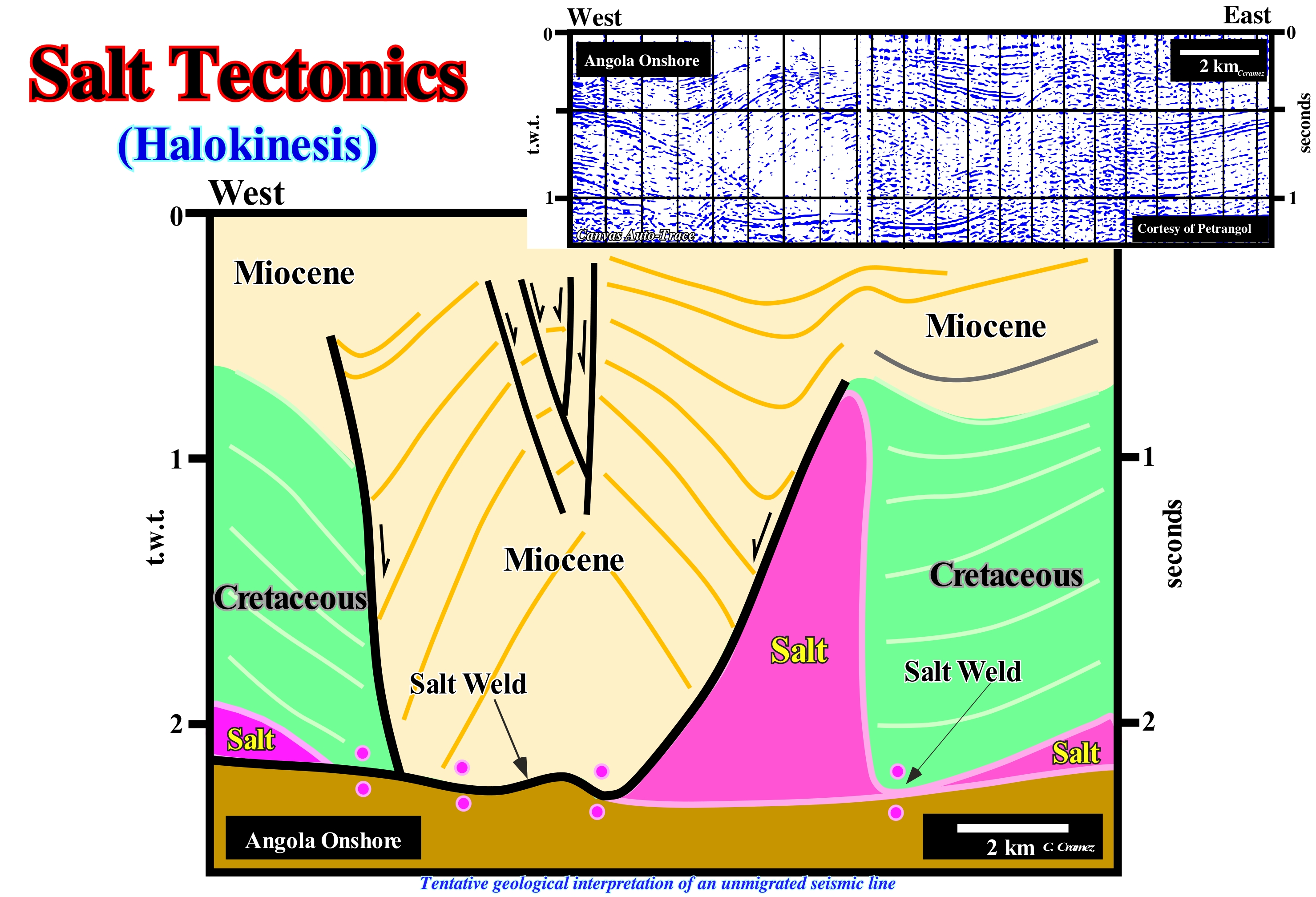
This tentative geological interpretation of seismic line from Angola onshore, shot in the 1960s (unmigrated line), is approximately the same as that proposed by the geoscientists of Petrangol (a subsidiary of the former Petrofina, which was later bought by Total). In the 1960s, Petrangol geoscientists working on the Angola onshore (Kwanza geographic basin) advanced the hypothesis that certain structures and the thickness variations in sedimentary observed on the field and on the seismic lines, could easier be explain by a lateral and vertical flow of salt interval, which had been crossed in the exploration wells (onshore). The salt interval (evaporites), which does not outcrop. The huge thickness variations of sedimentary intervals had already been described by the geologists of the American oil company Sinclair, which worked in the Kwanza geographic basin between 1904 and 1922. Brognon and Verrier (1966) and Masson (1972), explained the structure illustrated on this tentative interpretation (Quenguela Norte oil field), by a minimal extension (absence of tectonic regime) and a maximum reduction of salt (flow). In the 1990s, Duval, Cramez and Jackson (1992), taking into account the significant shortening (compression) of the sediments observed in the deep offshore area, proposed a completely different model, i.e., a model based on an maximum lengthening and minimum salt reduction. Locally<<<<8withoit taking into account the regional geological context, it can be said that: (i) The antiform structure of Quenguela ; (ii) The thickness variations of Miocene and (iii) The absence of Cretaceous in the core of the antiform structures, can be explained by the two models. However, taking into account the geological context of the basin, the compressive (shortening) structures observed in the deep offshore, can just be explained as a counterpart of the extent (lengthening) of the sediments observed in conventional offshore and onshore.
Halophyte (Halophytic, organism).................................................................................................................Halophyte, Halophytique
Halófito / Halófito / Halophitisch / 盐生植物 / Галофит, солончаковое растение / Alofita /
Organism that lives in a soil or salty environment, as for example in the marshes, mangroves, beaches and coastal dunes, as well as in sabkhas. Synonym with Halohelophyte.
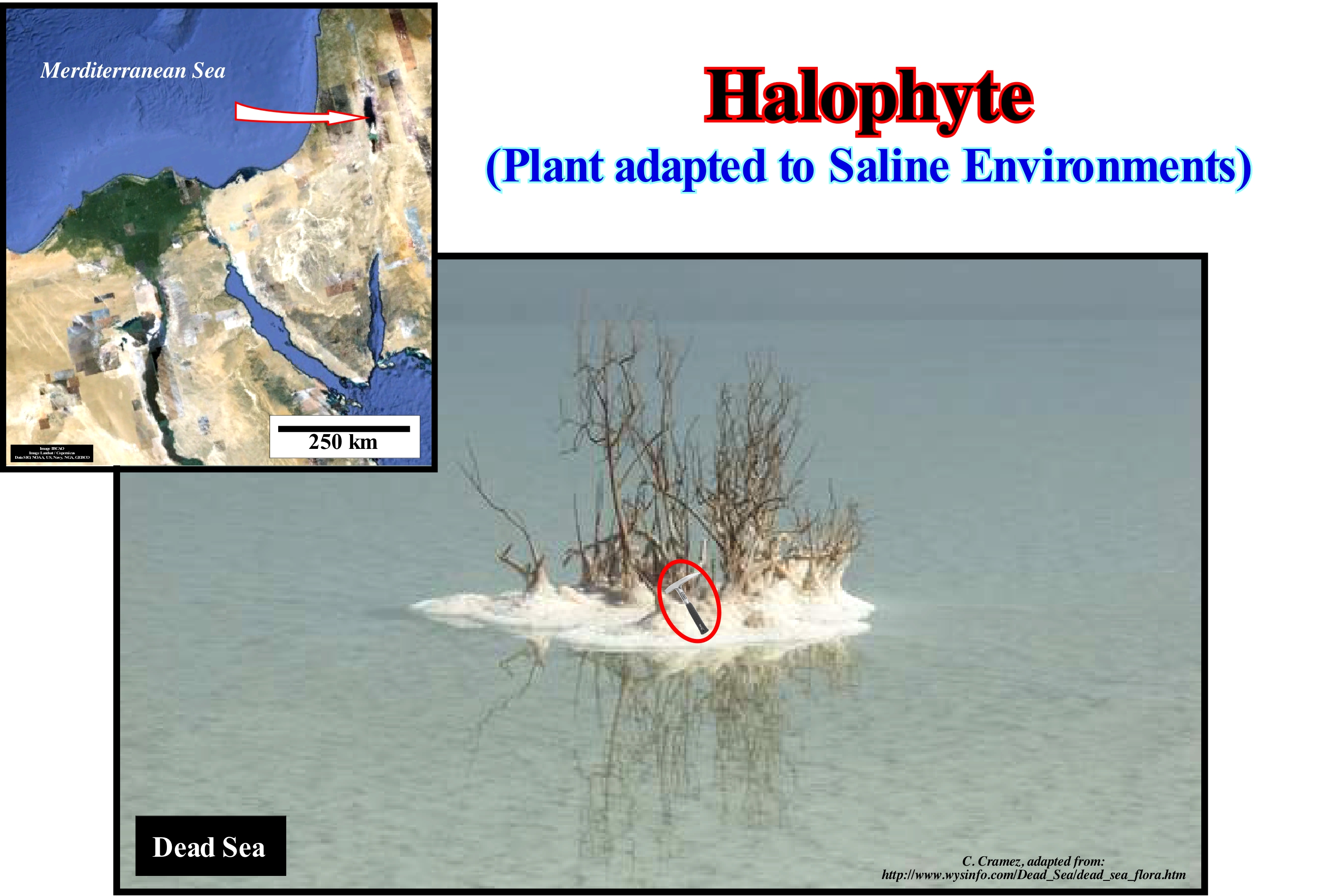
In botany, especially from the point of view of ecology, halophytes are plants, essentially, terrestrial adapted to live at or near the sea, because they are tolerant to salinity. Its tolerance can reach up to about 15 g of sodium chloride per litre, which is, roughly, equivalent to half of the concentration of sea-water. These plants absorb, for example, sodium chloride at high rates and accumulate it in their leaves to establish an osmotic equilibrium with the low potential of water present in the soil. Halophytic plants are those, for instance, that live in the mangroves. Some species of trees in this ecosystem have aerial roots that absorb oxygen from the air, for their respiration. Relatively few species of plants are halophyte plants (perhaps only 2% of all plant species). The vast majority of plant species are glycophytes (plants that are not naturally found in a saline substrate but tolerate, more or less, a certain amount of salt). They are, easily, damaged by the salinity of the water. The adaptation to saline environments by halophyte plants can be by salt tolerance (halo-tolerance) or by avoiding salt. Plants that avoid the effects of too much salt, despite living in a saline environment are called facultative halophyte plants, rather than true halophyte plants. A short-lived species that completes its breeding cycle during periods (such as in the rainy season), where the salt concentration is low avoids salt rather than tolerating it. Certain plant species may maintain an internal concentration of normal salt by excreting the excess salts through the leaves, or through a concentration of salts in the leaves that then die and fall. In prehistoric times, the halophyte vegetation was burned to produce alkaline potash. Potassium and other foundries of the Chalcolithic period (4th century BC) were discovered in Tuleylat el-Ghassal, about 10 km northeast of the Dead Sea, suggesting an important settlement in this area.
Halopsammophyte (Organism).........................................................Halopsamophyte, Halopsammophytique
Halopsamófito / Halo-psamófito / Halo - psammophitisch / Halopsammophite (身体的咸沙) / Халопсаммофит / Halopsammophite (Corpo di sabbia salata) /
An organism that lives in the salty sand of the beaches, coastal dunes or low sandy plains struck by sea-spray and where the water above the water table is salty or brackish.
See: « Sea-Spray »
&
« Halophyte »
&
« Brackish (water) »
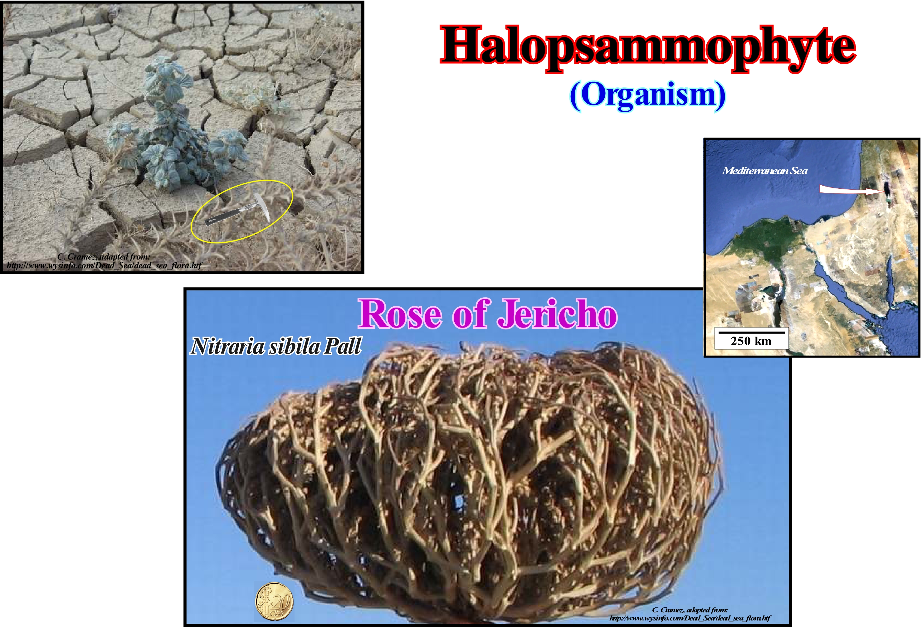
One of the typical examples of halopsammophyte organism is the Nitraria sibila Pall, illustrated in this figure, which is, preferably, found In Asia Minor and Central, in the Caucasus, Iran, Afghanistan is Syria. Nitraria sibila tolerates soils with salinity up to 30% of water soluble salts, mainly, in arenaceous soils, salt marshes, saline areas, riverside areas, etc. Nitraria sibila is a shrub that can reach two meters high and that lasts a long time (perennial), very branched and with many pimples. The leaves are alternate or in fascicles (1.0/2.5 cm long, 0.5/1.5 cm), large petioles (stem that lies between the hem and the leaf blade or limb of vascular plants), fleshy, oval-shaped with a narrow end at the base (ovobatecuneata), with rounded or obtuse apices, which have a shallow or notched central notch and small persistent stipules (scaly structures located on the stem of many vascular plants, together leaves). The flowers are biannual, 5 to 8 mm in diameter, actinomorphic (with radial symmetry), pentamers, i.e., they have five leaves at each whorl (stem point where leaves are inserted, commonly known as a knot) and with annual branches gathered in summits. The calyx is composed of five sepals (foliate structures, usually smaller and more consistent than the petals, which in most cases have the primary function of protecting the floral bud, closing on it before the anthesis, i.e., before opening of flowers). The calyx is persistent, with five petals (structures that form the corolla and which are usually membranous, broad, colourful and with many functions, among which the attraction of pollinators), free, hyspid (covered with hair or hard bristles) and with 15 or more stamens (leaves modified in male reproductive organs, producers of pollen grains) inserted in the margin of the floral disc. The fruit of the Nitrari sibila is eaten by all animals that live in the areas where it occurs. Nitrari sibila is a halophyte plant that accumulates salt and stabilizes sand from saline areas. It is used for the restoration of salt-affected soils and as a valuable source of potassium for soap making.
Haloturbation...................................................................................................................................................................................................Haloturbation
Haloturbação / Haloturbación / Haloturbation / Haloturbation, 体积变形(盐页岩) / Галотурбация / Haloturbation, Volume deformazione (sale scisti) /
Deformation of sedimentary structures, surface formations or soils due to the volumetric modifications of the saline clays of the marine and fluviomarine marshes and lagoon banks.
See: « Halokinesis »
&
« Haloclasty »
&
« Compensatory Subsidence »
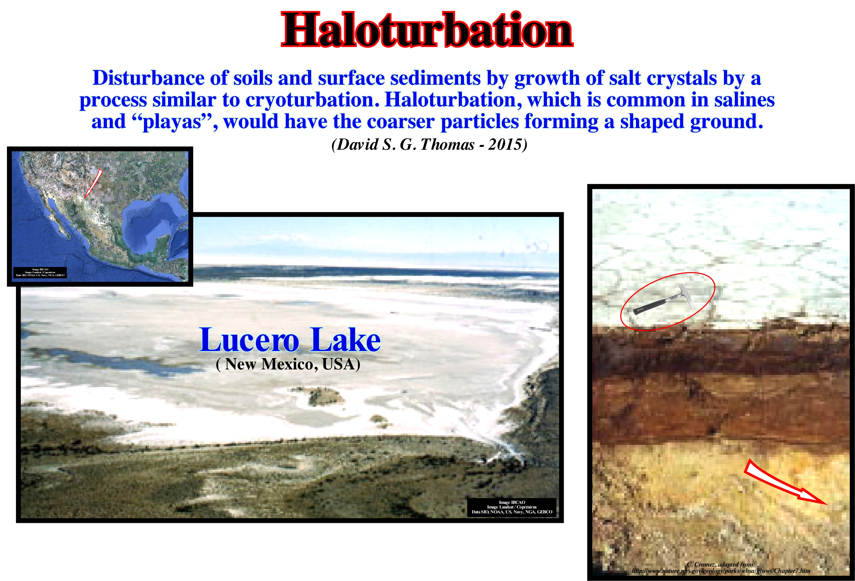
Haloturbation is an important deformation process, usually, involving gypsum or halite. In salines and tidal-plains plains, superficial cracks are very common, which, sometimes, they form very characteristic polygons. Likewise, carbonate crusts or other minerals are equally frequent. Flaking surfaces with a precipitation of gypsum are also common. In this photograph, sandy detritic muds came toward the coastal zone by surface runoff and were deposited on the beach surface at the mouth of the Andrecito stream in Lake Lucero. Desiccation fractures on the beach surface are evident. An interval muddy brown sand shows extreme haloturbation. The underlying sediments are gypse deposits, i.e., the surface that limits the brown mud and the white gypse marks the unconformity between Pleistocene and Holocene sediments. The evaporites inter-digitations and the sand beds observed in Grayburg formation (Texas) of the Palo Duro basin show magnificent examples of haloturbation (Nance, 1986). These deposits accumulated in a basin of 28,000 km2 epicontinental characterized by regional and episodic aridity, close to the influx of hypersaline marine waters. In each of the several recurrent progradational stratigraphic cycles a series of different sedimentary environments are developed, such as wind dunes, zones between dunes, sand mantles, salty mud and a large and shallow marine brine (saline). Siliciclastic sources were found at the west and north-west, while the brines were derived from the south and southwest. The deposits of fine-grained sandstone dunes exhibit cross-stratification with a medium to high angle (15-35°). In the areas between the dunes layers, more or less, horizontal or wavy sand of fine with illuviation structures were deposited. The sand mantles are characterized by well-calibrated horizontal deposits of very fine sandstones with illuviation structures. The sand mantles and the tidal flat muds are formed by sands and silts with graded bedding, ripples, structures in flaser*, etc. are deformed internally by haloturbation.
(*) In sedimentary rocks, "flaser" is an elongated lenticular clay structure formed by the deposition of mud in the depressions of the wave or current marks during phases decrease of the flow or the oscillations of waves and that are later covered by new depositions of sand covering these lenses and causing cross-laminations.
Hanging Glacier..................................................................................................................................................................................Glacier suspendu
Glaciar suspenso / Glaciar colgante / Hängende Gletscher / 挂冰川 / Висячий ледник / Ghiacciaio pensile /
Glacier that is in the high part of the wall of a glacier valley and that, generally, does not descend to the main glacier. Avalanches and ice falls are the transfer mechanisms of ice and snow toward the glacier valley.
See: « Glaciation »
&
« Milankovitch's Cycle »
&
« Glacier »
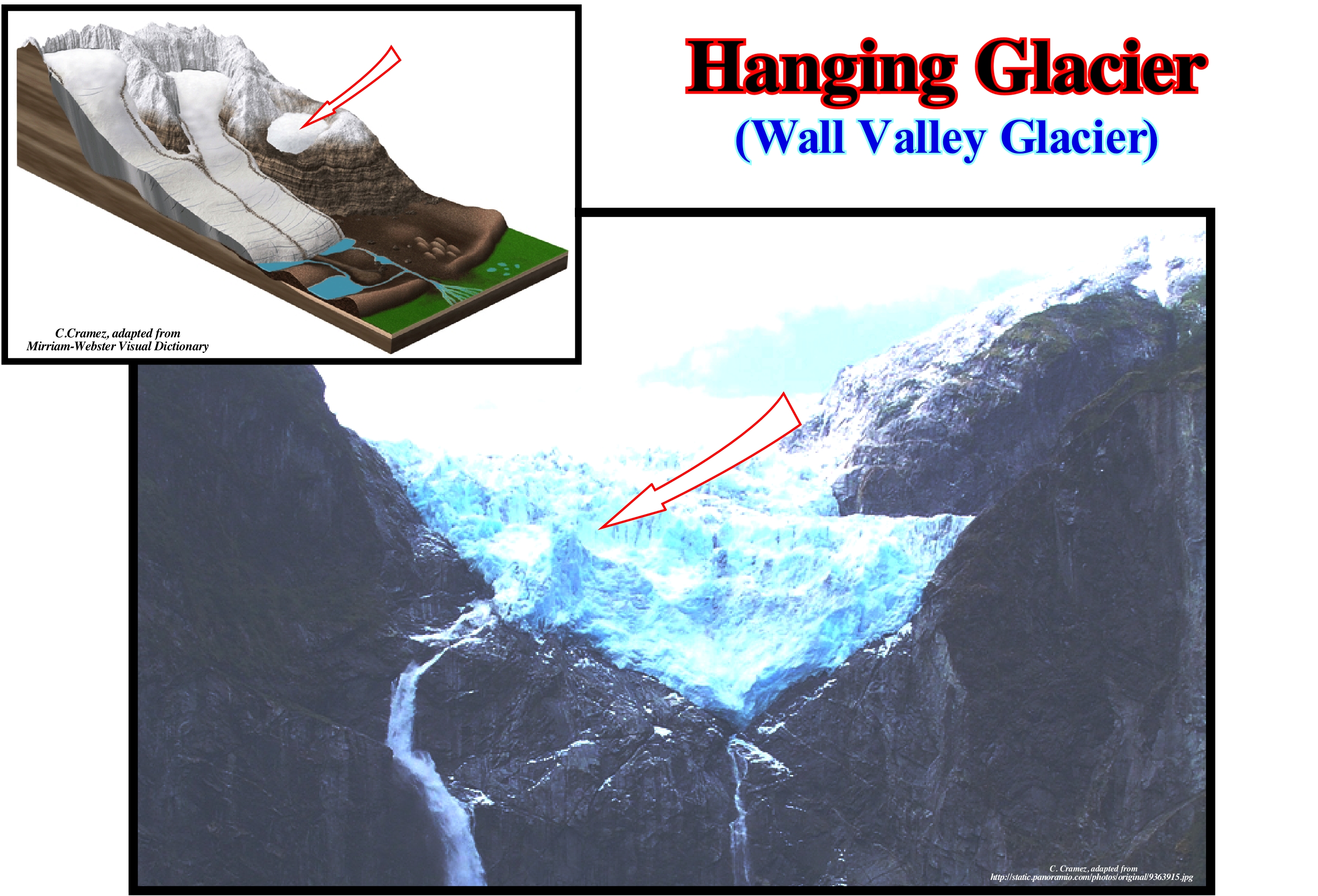
As illustrated in this photograph, a hanging glacier ends at, or very near, the top of the wall of the main glacial valley. The calving induced by the thickening of the glacier creates ice avalanches, towards the glacier valley as one can predict on this photograph. In the scheme of the glacial environment, from top to bottom, the following elements can be observed: (i) Bergschrund* ; (ii) Snowfield (firn) ; (iii) Glacial cirque ; (iv) Hanging Glacier; (v) Substratum ; (vi) Riegel (transverse crest of the bedrock exposed by glacial erosion) ; (vii) Medial Moraine ; (viii) Fissure (crevasse) ; (ix) Lateral Moraine ; (x) Serac; (xi) Glacial tongue ; (xii) Water Flow ; (xiii) Ground Moraine ; (xiv) Terminal moraine and (xv) Outwash plain. In a glacier there are several types of fissures (crevasses) : (a) Transversal ; (b) Marginal ; (c) Longitudinal ; (d) Bergschrund and (e) Calving** . The transversal fissures are the most common. They form in the zone of lengthening or extension (zone where the glacier accelerates its downhill movement). The transversal fissures are perpendicular to the direction of movement of the glacier and, generally, opened. The marginal fissures are, diagonally, oriented to the extremity of the glacier. They extend upstream, since the glacier's velocity is higher in the central part than in the margins. The longitudinal fissures or longitudinal crevasses form parallel to the movement of the glacier when the width of the glacier expands. Bergschrund (departure fissure) separates the part of the glacier that is in motion from the part that is stagnant (they can extend to the rocky substrate). Calving forms at the end of a hanging glacier. A glacier is like a stream of ice. It exists, just, as it flows, that is, while accumulation is balanced by ablation. If ablation is greater than accumulation, the glacier does not shrink, it continues to flow downhill, but thinning.
(*) A fissure behind the glacier, between the rocky wall and ice, parallel to the rocky wall, and induced by rotational motion of the glacier.
(**) Glaciofracturation, which represents the main form of ablation of a glacial system, corresponds to the individualization of ice blocks by fracturing, either in an iceberg or in the front part of a glacier.
Hangingwall............................................................................................................................................................................................................Bloc faillé supérieur
Bloco falhado superior / Bloque fallado superior / Hängende Mauer / 上盘 / Висячее крыло сброса / Hangingwall, Blocco di faglie superiore, Parete d’attaccatura /
Faulted block above of dipping fault plane. Also called Upper Faulted Block.
See: " Footwall "
&
" Fault "
&
" Seismic Line "
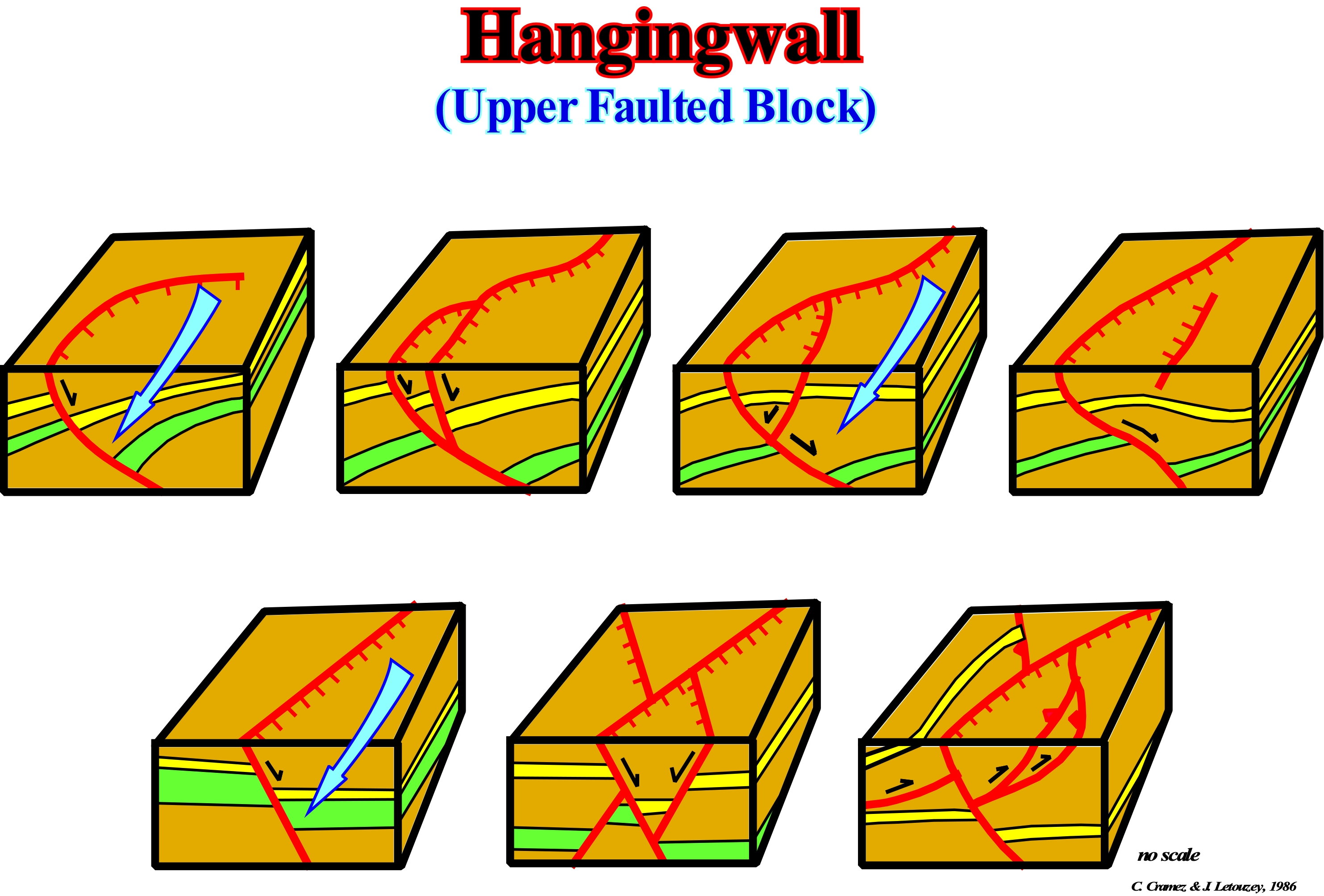
When walking on a fault plane, a geoscientist moves on the lower faulted block (foot-wall). In a normal fault, the upper faulted block (hangingwall) is always the block that has been lowered relative to the foot-wall. In a reverse fault, it is the opposite. The hangingwall is the faulted block that has risen relative to the foot-wall. These block diagrams, in which, for simplicity, the upper part was drawn flat (topography flat), illustrate different possible complications of the hangingwall and the trace of the fault plane. The geometry of the vertical and horizontal sections must correlate. The map of a seismic horizon must be consistent with the tentative geological interpretation of the different seismic lines of the region (vertical and transverse sections). In a seismic line (cross-section), generally, the dip of the fault plane of a normal fault decreases quite, rapidly, in depth (do not forget that there are no vertical normal faults). In a map (horizontal section), that is to say, in cartography with a flat topography, the trace of such a fault is curvilinear in harmony with the trace of the fault plane in the cross section. The lower diagrams of this sketch and, particularly, the first two (from the left), in which the traces and dips of the fault planes are, practically, rectilinear, illustrate the upper part of faults in which the dip of the fault planes are approach the vertical. In these cases, the fault plane becomes much less steep in depth, the traces in a map become curve. When two normal faults, of different ages, intersect (X faults), the cross-section and horizontal geometries are very characteristic. The cross-section is characterized by the overlap, more or less, in the same vertical, of a "graben" (upper levels) on a "horst" (lower levels). In the horizontal plane, i.e., in a map, the trace of the most recent fault plane cuts and displaces the oldest fault trace. However, if there is a significant topography on the horizontal plane, it can deform the geometry of the fault planes and suggest that it is the most recent fault plane that is displaced by the oldest fault.
Hardground........................................................................................................................................................................................................Surface enduré
Nível endurecido (superfície) / Superficie dura, Hardground / Oberflächen ertragen / 表面忍着 / Затвердевшая поверхность / Hardgound /
Zone at the bottom of the sea, which may later be fossilized, usually, few centimeters thick, in which the sediments are lithified and form a hardened, crusty and, often, discoloured surface. This surface implies a pause in sedimentation or a very weak deposition rate and thus can not, generally, be considered as an unconformity.
See: « Condensed Section »
&
« Downlap Surface »
&
« Transgressive Interval »
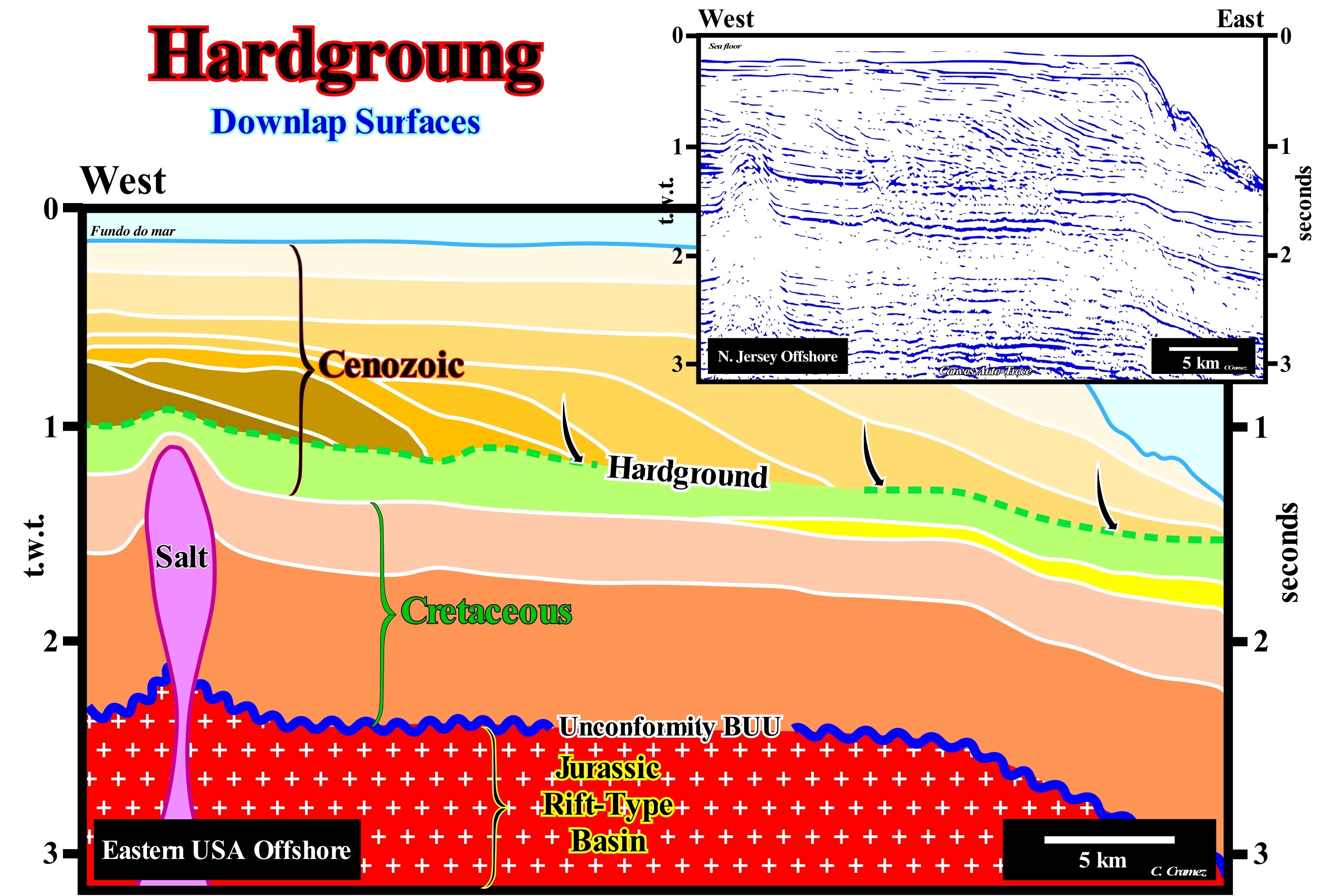
The eastern offshore of the United States corresponds to a stacking of different basins of the classification of the sedimentary basins ( Bally and Snelson,(1980). In a regional seismic line, generally, from bottom up, a geoscientist recognizes: (i) A basement or a Paleozoic mountain belt, that works like an infrastructure and corresponds to the Pangea supercontinent ; (ii) Rift-type basins that lengthened the supercontinent prior to the break-up of the lithosphere and (iii) An Atlantic-type divergent margin, formed above a thick accumulation of lava flows deposited during the volcanic sub-aerial expansion that pre-date the oceanic expansion. In divergent margin two sedimentary tectonic phases are recognized: (i) Transgressive Phase and (ii) Regressive Phase. The transgressive phase was deposited during a rise of absolute (eustatic) sea level (supposed global and referenced to the Earth's centre). The transgressive phase is covered by the regressive phase that was deposited during 1st order Mesozoic / Cenozoic eustatic cycle of the absolute sea level. Locally, the transgressive phase has a parallel geometry. However, globally, its geometry is retrogradational, since it is corresponds to a set of increasingly important marine ingressions and the associated increasingly smaller sedimentary regressions. During the regressive phase, whose geometry is progradational, as we can, easily, see on this tentative interpretation, marine ingressions are increasingly less important and the associated sedimentary regressions, increasingly important. As illustrated on this tentative geologically interpretation of a Canvas auto-trace of a Baltimore Cannon (US) seismic line, the hardground levels, which, generally, correspond to, highly, condensed stratigraphic sections, are, practically, always fossilized by downlap surfaces. Hardground levels represent periods of no deposition or periods with a very small sedimentation rate. These conditions occur, for instance, within a sequence-cycle (stratigraphic cycle), when the depositional centres are displaced upstream (continentward) due to a significant relative sea level rise in acceleration. Since the relative sea level (not to be confused with absolute or eustatic sea level) begins to rise in deceleration (marine ingressions increasingly smaller), the depositional centres move, progressively, seaward and the hardgrounds are, partially or totally, fossilized by the overlying progradational sediments. On this tentative to interpretation, the fossilization of the hardgrounds seems to have been more complex. It was not done during the deposition of the highstand prograding wedge of a stratigraphic cycle (sequence-cycle), as said before, but by the deposition of a series of continental encroachment sub-cycles** with progradational geometry. These sub-cycles were deposited in association with successive absolute (eustatic) sea level falls that occurred during the Neogene**. A global sea level fall (more or less continuous fall of absolute or eustatic sea level) involves, necessarily, several relative sea-level rises, of a smaller hierarchy, which are the true responsible of the deposition). Due to their lithological characteristics, the hardground surfaces have strong acoustic impedances and, therefore, they can induce seismic reflections with strong amplitudes. In certain basins, several amplitude anomalies, initially, interpreted as being induced by the presence of hydrocarbons in reservoir-rocks, correspond rather to hardground surfaces. Many animals perforate the sediment forming the hardground (bioerosion). One of the best known examples is the lithophagous (sediment-eating) bivalve mollusc: Lithophaga Lithophaga. Many animals encrust hardground surfaces (oysters, bryozoans, barnacles and crinoids, etc.).
(*) Note that here we are speaking at the hierarchical level of continental encroachment stratigraphic cycle, induced by the first order eustatic cycle (Post-Pangea eustatic cycle), which is defined in relation to the absolute (eustatic) sea level and not by relative sea level changes is the case in a sequence-cycle.
(**) The geometry, more or less, sub-horizontal of the hardgrounds suggests these sub-cycles were conditioned, almost exclusively, by eustasy. The influence of the tectonic factor was, practically, non-existent.
Harpan (Calcrete).........................................................................................................................................................................................................................Calcrète
Calcrete / Calcreta / Calcret (Caliche) / 钙质结砾岩(硝酸钠), 砂砾层 / Кальцикрит (нитронатрит) / Calcrete (caliche) /
Level or hardened layer of a soil formed in calcareous terrain due to climatic variations in arid or semi-arid regions. The calcite dissolved in groundwater (under certain conditions) is precipitated when water evaporates. CO2 saturated rain-water acts as an acid and dissolves the calcite, which is then deposited on the surface of the particles that compose the soil. When the spaces between the grains of the soil are filled by calcite an impermeable crust is formed, that is, a calcrete.
See: « Soil »
&
« Incrusting Water »
&
« Calcite »
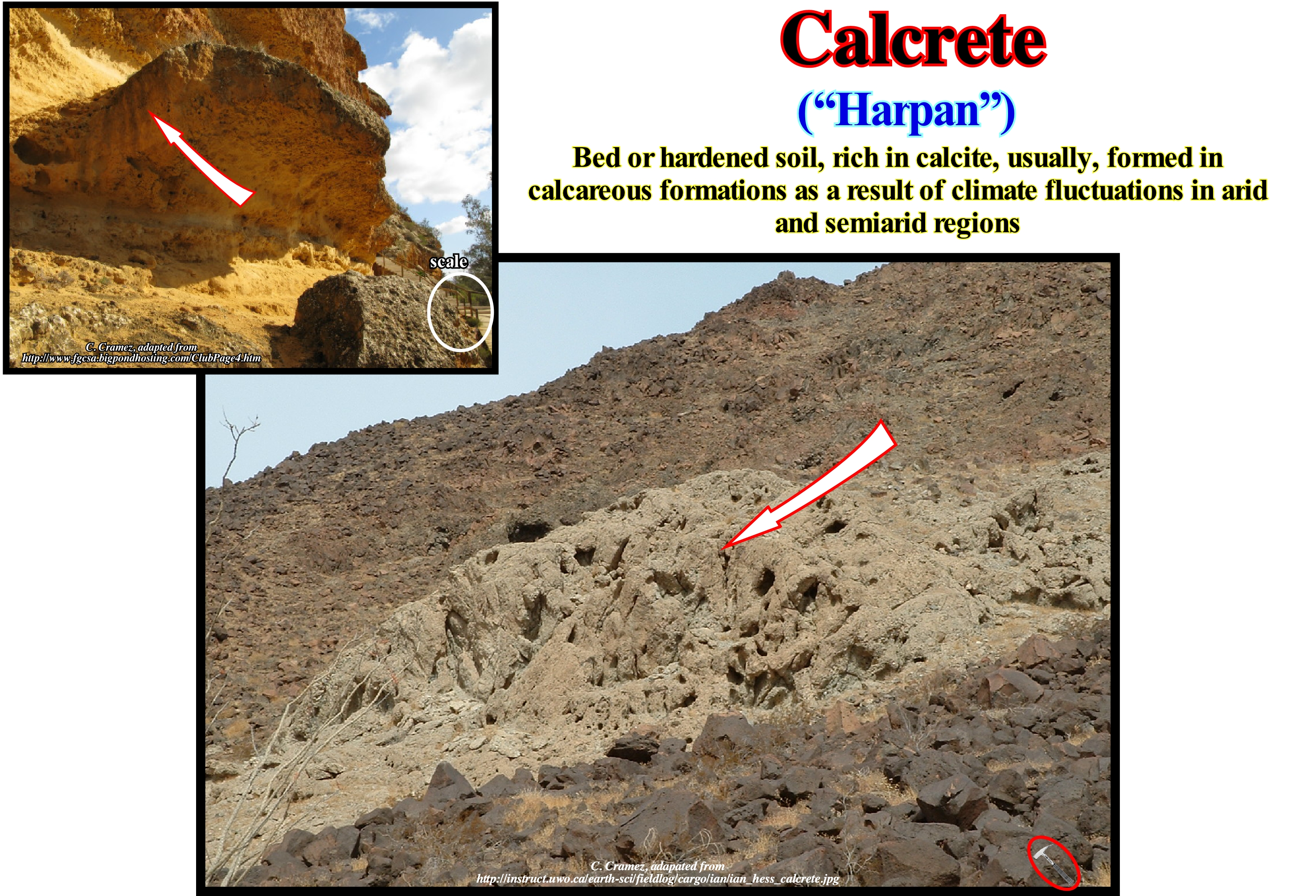
Hardpan is also called calcrete, which means lime in Spanish, "hardpan", "kankar" (India) or even hard crust, which corresponds to a deposit of hardened calcium carbonate, which cements other materials, such as, gravel, sand, silt and clay. This type of deposit occurs in almost every part of the world particularly in the arid or semi-arid, for example in central and western Australia, Kalahari and Sonoran deserts, as well as in the high plateaus of the western United States of North America. The hardpan is, generally, light in colour, but depending on the impurities its colour may vary from white to red/brown. The hardpan, generally, is to the terrestrial surface or near this surface, although also it can be found in deep undergrounds. As illustrated in these photographs, hardpan horizons can have very varied thicknesses (centimeters to meters) and several levels may exist in the same place. Hardpan is usually formed when the minerals of the upper part of the soil (horizon A *) are levied and accumulate at the level of the underlying soil (horizon B) at depths ranging from 1-3 meters. As stated above, hardpan or calcrete consists of carbonates in semi-arid regions, whereas in arid regions, less soluble minerals form calcrete horizons after all carbonates have been leached out of the soil. The deposited calcium carbonate first forms grains, which then form small groups, which, over time, form a more or less visible horizon, which finally forms a thick, competent layer. As a hardpan horizon, gradually, forms, its lower boundary becomes deeper and may even reach the rocky substratum.
(*) In a vertical profile of the soil, in addition to the consolidated rock, there are generally four horizons: (i) O ; (ii) A, which has two subdivisions: A1 and A2 ; (iii) B and (iv) C. The O horizon is mainly composed of deposits of dead organic matter. The A1 horizon is a humus-rich layer, consisting of partially decomposed organic material mixed with mineral soil. The A2 horizon is a region of intense leaching of soil minerals. The B horizon contains little organic material, whose chemical composition resembles that of the underlying rock (clay minerals and iron and aluminium oxides are leached out of the A2 horizon and eventually deposited in this horizon). The C horizon consists mainly of slightly modified material from the consolidated rock). Depleted eluvial (eluvium) horizons (E horizon of many geoscientists) in clayey particles are generally under the horizon A.
Heavy Crude Oil.................................................................................................................................................................................................Huile lourde
Óleo pesado / Petróleo pesado / Schweröl / 重油 / Необработанная нефть / Olio pesante /
Oil having a high wax content, i.e., with a viscosity greater than 10 cps (p=poise, the physical unit in the CGS system for viscosity). The differentiation between light and heavy oil is, purely, practical. An oil with a high viscosity (> 10 cP) is more difficult to pump and transport because it is heavier. The relative density of a liquid oil is given in API (American Petroleum Institute) degrees, which indicates whether the oil is lighter or heavier than water. When API> 10, the oil is light and floats in the water. When gravity API <10, the oil is heavy and seeps to the bottom of the water.
See: « Oil »
&
« Hydrocarbon »
&
« Light Oil »
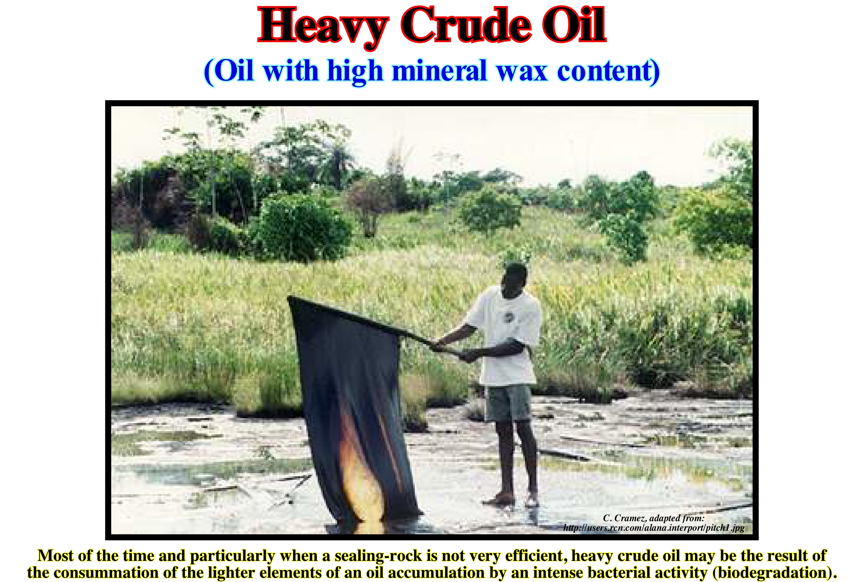
Heavy crude oil is, often, used as fuel in oil and transport vessels. Likewise, it is used in power plants, which use the combustion of petroleum as a source of energy. As shown in this figure, the heavy crude oil is thick, viscous and sticky. Its consistency makes it ideal for skimming and cleaning operations at sea, but it is much harder to treat and clean when it flows, either naturally or artificially, on the mainland and on animals. In this type of liquid petroleum, only about 5-10% evaporates in the first few hours after a stroke. Its specific gravity is very close to the gravity of the water, so that it can float, fall to the seabed or both. As the lighter oil evaporates it becomes heavier and darker. In case of heavy oil spillage in the sea, when it reaches the coast, it forms a large black polluting spot that must be quickly removed. Its rapid removal is necessary not only because the degradation of the heavy oil is very slow, which can take months or years, but also because: (i) It glues to the fauna that lives in the surface waters ; (ii) It kills intra-tidal animals and (iii) It pollutes the sediments. For marine organisms, heavy oil is not as toxic as light oil. In the event of a sea spill near the coast, the mortality rate can be very important for sea-birds, seals and ducks, especially for populations concentrated in small areas, such as during migration periods of birds and marine mammals.
Heavy Oil (Heave petroleum).........................................................................................................................................................................Huile lourde
Óleo pesado / Petróleo pesado / Schweres Rohöl / 重质原油 / Тяжелая нефть / Greggio pesante /
Oil with a high wax content, typically having a viscosity above 10 cP (the unit cgs for dynamic viscosity is poise (P), which is expressed, usually, in centipoise, cP) and with a high density. Considered, sometimes, as synonymous of Heavy Oil. Geoscientists reserve the term petroleum for a natural oil of mineral origin.
See: « Oil »
&
« Hydrocarbon »
&
« Light Oil »
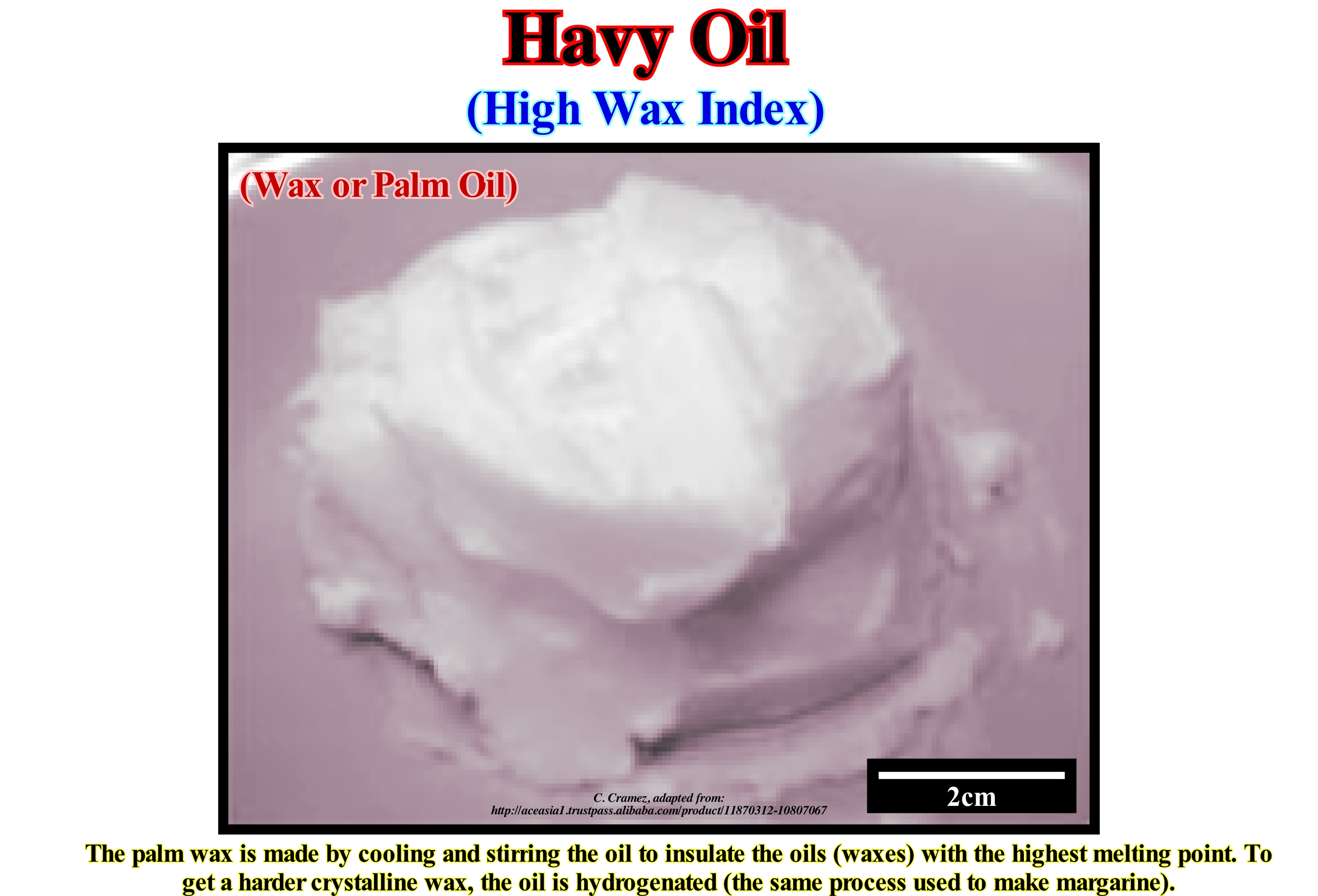
The distinction between "light" and "heavy" oil is, purely, practical. A heavy oil with a high viscosity (greater than 10 cP) is more difficult to pump and transport because it is heavier. Some geoscientists consider that a lipid (organic substance insoluble in water, soluble in benzene and ether and formed of fatty acids bound to other bodies), whether it is light or heavy, when it is liquid, is an oil and, when it is solid it's a fat. The scientific term for the oils, fats, waxes, cholesterol and other oily substances found in living things and their secretions is lipid. Lipids, ranging from waxes to steroids, are difficult to characterize. They form a group just because they do not dissolve in water (miscible in other lipid liquids) and because they are high in carbon and hydrogen and are relatively poor in oxygen. Physically, it can be said that the oils are liquid lipids at room temperature, while the fats are solid. Chemically, either one or the other is composed of triglycerides (glycerol molecule, i.e., an aliphatic alcohol with three oxidils in the molecule, combined with three fatty acids in each molecule) as opposed to waxes which do not have glycerine in their structure. Although many parts of the plants can be used to produce oil, in commercial terms, the oil is extracted, basically, from seeds. The distinction between oils and fats from the melting temperature is very imprecise, not only because the ambient temperature varies from one place to another but also because the oils do not have a single melting temperature, (it may vary within certain limits). Vegetable fats and oils can be edible. Examples of non-edible oils include linseed oil, vernice oil (Tung-oil), castor oil, etc. which are used as lubricants, paints, cosmetics and pharmaceuticals.
Helictite (Speleothem)...........................................................................................................................................................................Helictite (Spéléothème)
Helictite / Helictita (espeleotema) / Excentrique, Höle Ablagerung / Helictite (洞穴存款) / Сталактит скрученной формы / Helictite (deposito di grotta) /
Speleothem found in the caves of limestone rocks, which changes its vertical axis in one or more stages of its growth. The helictites have a curved or angular shape as if they grew in absence of the gravity field.
See: « Heligmite »
&
« Stalagmite »
&
« Cave »
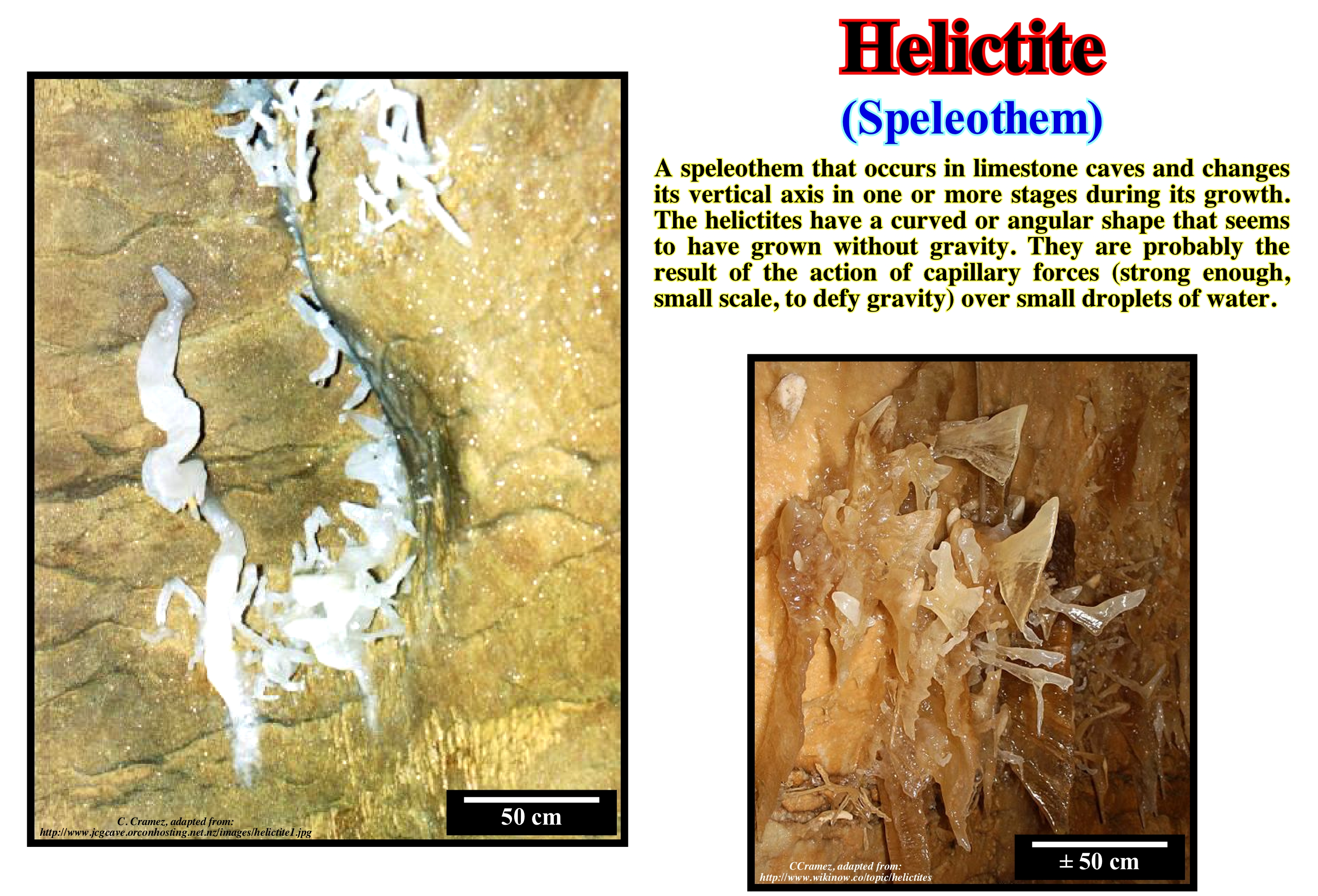
The helictites are perhaps the most delicate of the formations of the caves. They are, usually, made up of calcite and aragonite needles and can take many forms: ribbon, saw, bars, butterflies, hand shaped, etc. Usually, the helictites have a radial symmetry and can be, easily, broken by a light touch. Therefore, in caves open to tourists, they are, rarely, at reach of visitors. The most probable theory to explain the helictites invokes the capillary forces. Because the helictite has a thin central tube where water flows (as in straws used to drink refreshments), capillary forces carry water against gravity. This theory was inspired by hollow helictites. Most of the helictites are not hollow. The droplets can be drawn to the tips of existing structures and deposit their calcite load anywhere, which can create helictites in varied shapes. Another theory admits that the wind inside the caves is the main cause of the complicated forms of the helictites. The drops hanging on a stalactite are blown to one side, so the speleothem grows in that direction. If the wind changes, the direction of growth also changes. This theory is very problematic because the wind directions change very often. The wind in the caves depends on external air pressure changes, which in turn depend on the weather. The wind changes direction whenever the weather changes. But speleothems grow very slowly (a few centimeters in 100 years), meaning that the direction of the wind would have to remain stable for long periods of time, shifting to every one-millimetre fragment of growth. Another problem with this theory is that many caves with helictites do not have natural entrance through which the wind can wind in. Another theory proposes that a slow alteration of the geological pressure causes stresses at the base of the crystals which alters the piezoeletrostactic potential* and causes the deposition of oriented particles in relation to the prevailing pressure orientation.
(*) Piezoelectricity is the property that certain bodies have to electrically polarize under the action of a mechanical force and reciprocally to deform under the action of an electric field.
Heligmite (Speleothem)..................................................................................................................................................................Heligmite (Spéléothème)
Heligmite / Heligmita (espeleotema) / Heligmite (Höhlensinter) / Heligmite (石笋) / Хелигмит / Heligmite (speleotema) /
Helictite (speleothem found in caves of limestone rocks, which changes its vertical axis in one or more stages of its growth) that develops in the soil, instead of developing in a wall or ceiling, although there are exceptions. The heligmites are structures similar to the great stalagmites. The large heligmites (say 30 cm in height and 5 in diameter) have a central channel about 5 mm in diameter in the main part, which becomes microscopic at the tip.
See: « Helictite »
&
« Stalagmite »
&
« Speleothem »
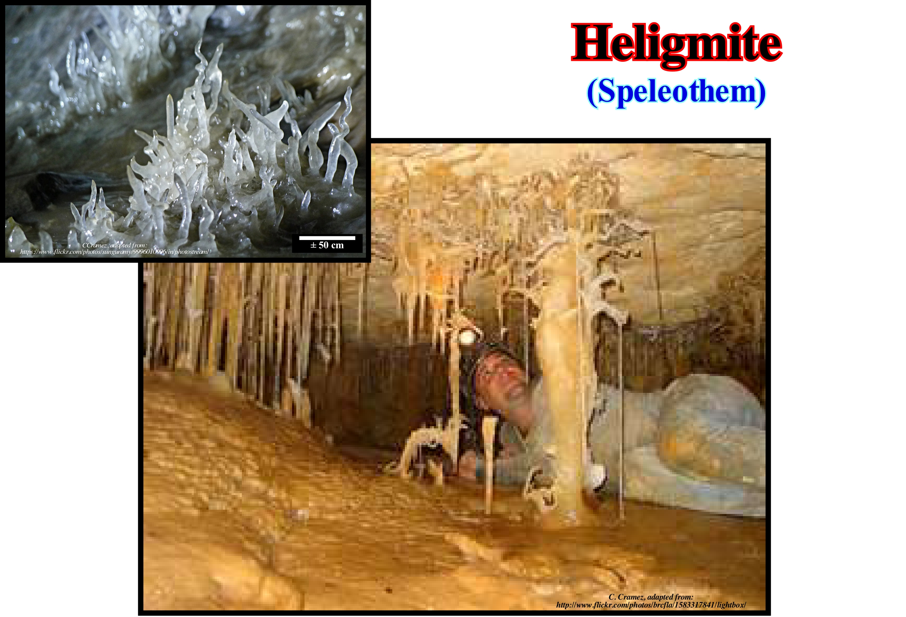
The heligmites are, generally, classified as helictites that simply develop on the floor instead of a wall or ceiling. There are some exceptions, in which heligmites have to be classified separately. In this case, the heligmites correspond to large speleothems similar to a stalagmite. They have a central channel. In large heligmites (say 30 cm in height and 5 cm in diameter), the central canal may be about 5 mm in diameter in the main part of the heligmite but be practically microscopic at the tip. In this type of heligmite, the central channel is filled with a thin sticky sludge. Great heligmites can be observed in the cave of Tantanoola (South of Australia), where of them they developed in a dolomitic cave. Other examples can be seen in the cellars of Jenolan Cave, where the heligmites may have lateral branches. Certain heligmites from the Jenolan cellars have a dark material, probably manganese dioxide which has been deposited together with calcite. In some heligmites of Tantanoola this dark material also seems to be present. Certain geoscientists argue that these large heligmites are, really, geysermites. However, the definition of geisermites specifies that they have thin sidewalls and a central hole, which is not the case for heligmites that have very thick sides and have no central holes. On the other hand, in both caves, speleothems are developed in an area that has no geysers (hot spring that erupts periodically, throwing a column of hot water and steam into the air) or hot springs. The upturned helictites (returned) have, usually, the form of a worm. Initially, they grow horizontally, and then vertically (upward). The horizontal development is usually only 5 cm in length, whereas, the vertical development may be several meters in length.
Helophyte...................................................................................................................................................................................................................................Helophyte
Helófito / Helófito / Helophitisch, Sumpfpflanze / 沼泽植物 / Галофит / Helophyte /
Organism that lives rooted or buried in the salty mud. Some geoscientists consider it as halohelophyte or helohalophyte (both forms of writing seem to be correct). Synonym with Halophyte.
See: « Halo-helophyte »
&
« Sea floor »
&
« Halophyte »
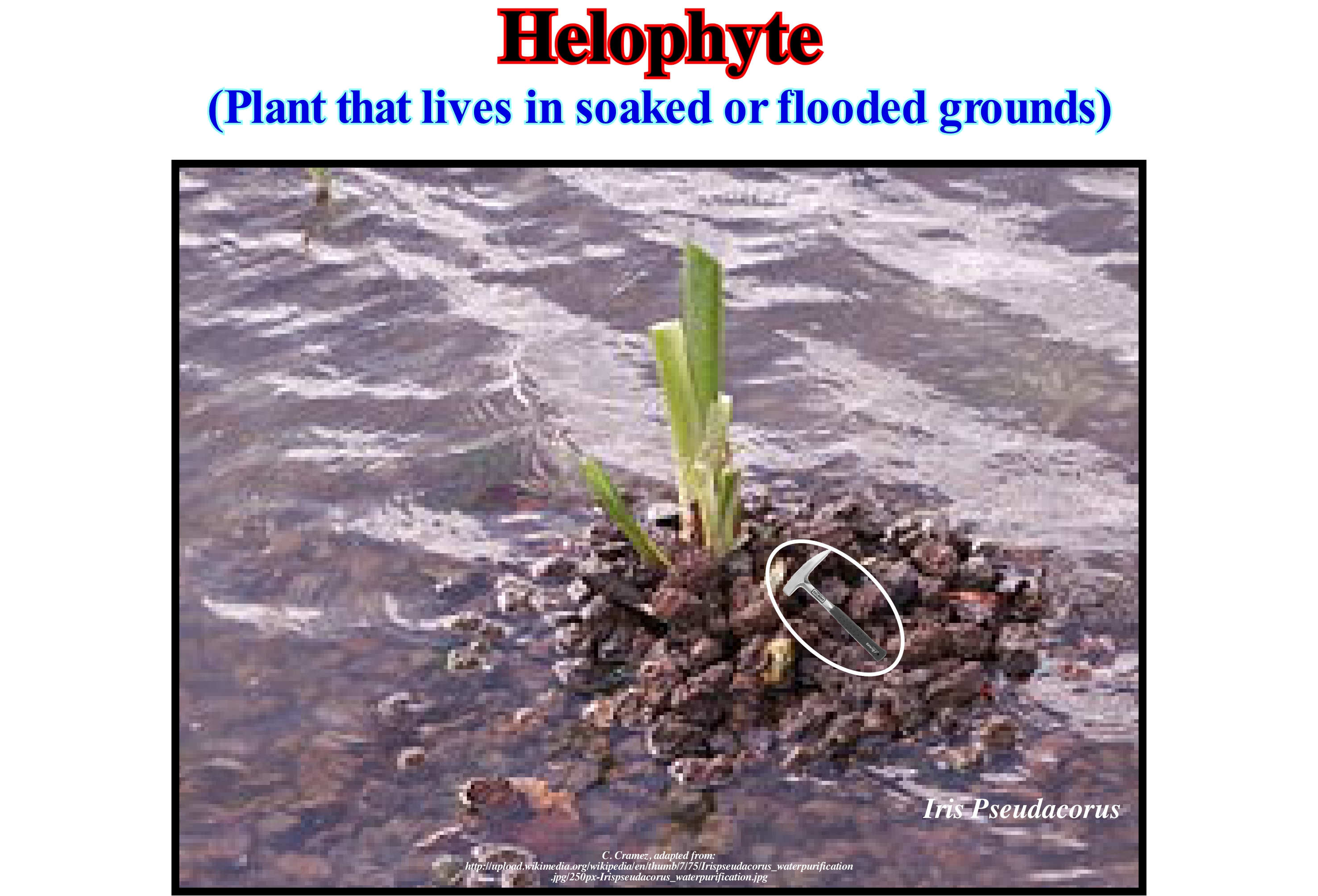
A halophyte organism has an absolute need for strong concentrations of salt to live. These organisms accumulate in the cytoplasm large amounts of salt, mainly KCl. They prevent the loss of water by osmosis. These organisms impose a cellular stress, which causes the insolubility and precipitation of the proteins. In helophyte organisms, proteins are not only soluble and functional at high concentrations of KCl, but are denatured when the concentration of salt decreases. Certain algae or continental bacteria introduced into the sea by the rivers secrete and accumulate in the cytoplasm solutions of amino acids, such as glycine betaine. At present, it is not possible to say with certainty whether helophylic proteins are the result of adaptation to extreme environments, or whether, on the contrary, they represent the survival of primitive living conditions with high salt content. The helophyte plant illustrated in this figure is Iris pseudacorus, which is often to purify rainwater on the roofs of collection so that it can be used for agricultural irrigation. There are two types of halophyte organisms: (i) Halo-tolerant and (ii) Halo-obligatory (unable to grow in non-hypersaline environments). A halotolerant organism is an organism that can adapt to very high salt concentrations. Most of these organisms are bacteria and halotolerant unicellular algae. They can adapt to these conditions by producing small molecules in large quantities, such as glycerol, molecules that accumulate in the nucleus of cells. The concentration of the dissolved molecules becomes equal to the sodium chloride (NaCl) concentration of the environment. Water no longer escapes the cells and biochemical conditions are not inhibited. Staphylococcus aureus is a Gram + bacterium (Gram is a methylene blue staining, the bacteria that colour in pink are Gram-, the violet-coloured bacteria are Gram +), which is halophytic. It can be grown in media with high salt concentration. Especially in a Chapman medium*, which is a concentration of 75 g NaCl / l, that is, equivalent to twice the sea level (37.5 g / litre).
(*) Chapman agar is the selective medium for halophilic bacteria and more particularly fermenting mannitol. It is a semisynthetic medium.
Hemera (Biocron)........................................................................................................................................................................................................................Héméra
Hemera / Hémera / Hemera / ヘーメラー / Гемера / Emera/
Particular case of biochron (vertical distribution of characteristic species within a zone), which is the maximum development duration or acme of a species or other taxon or the apogee biozone.
See: « Biochron »
Hemipelagic Mud................................................................................................................................................................Boue hémipélagique
Lama Hemipelágica / Lodo hemipelágico / Hemipelagischen Schlamm / 半深海泥 / Гемипелагический аргиллит / Fango Hemipelagic /
Mixture of biogenetic carbonate material and terrigeneous clayey sediments. The term mud is used to describe a loose, sticky, loose sludge deposited, often, on the coastal shorelines and at the mouth of water-courses due to flocculation* and the sedimentation that occurs during the high tides.
See : « Deep Seafloor »
(*) Process in which clayey particles in suspension, in contact with sea-water, coagulate and deposit rapidly.
Hemipelagic (Organism)............................................................................................................................................Hemipélagique (Organisme)
Hemipelágico / Hemipelágico (organismo) / Hemipelagischen / 半深海 / Гемипелагический организм / Hemipelagic /
An organism that lives in the hemipelagic region, which in oceanography is the region of the ocean extending from the border of the continental shelf (sometimes is the basin edge) to the pelagic environment, which corresponds, more or less, the zone bathyal, whose lower limit is between 200 and 1,000 meters of water-depth.
See: « Pelagic (deposit) »
&
« Hemi-pelagic (sediment) »
&
« Sediment »
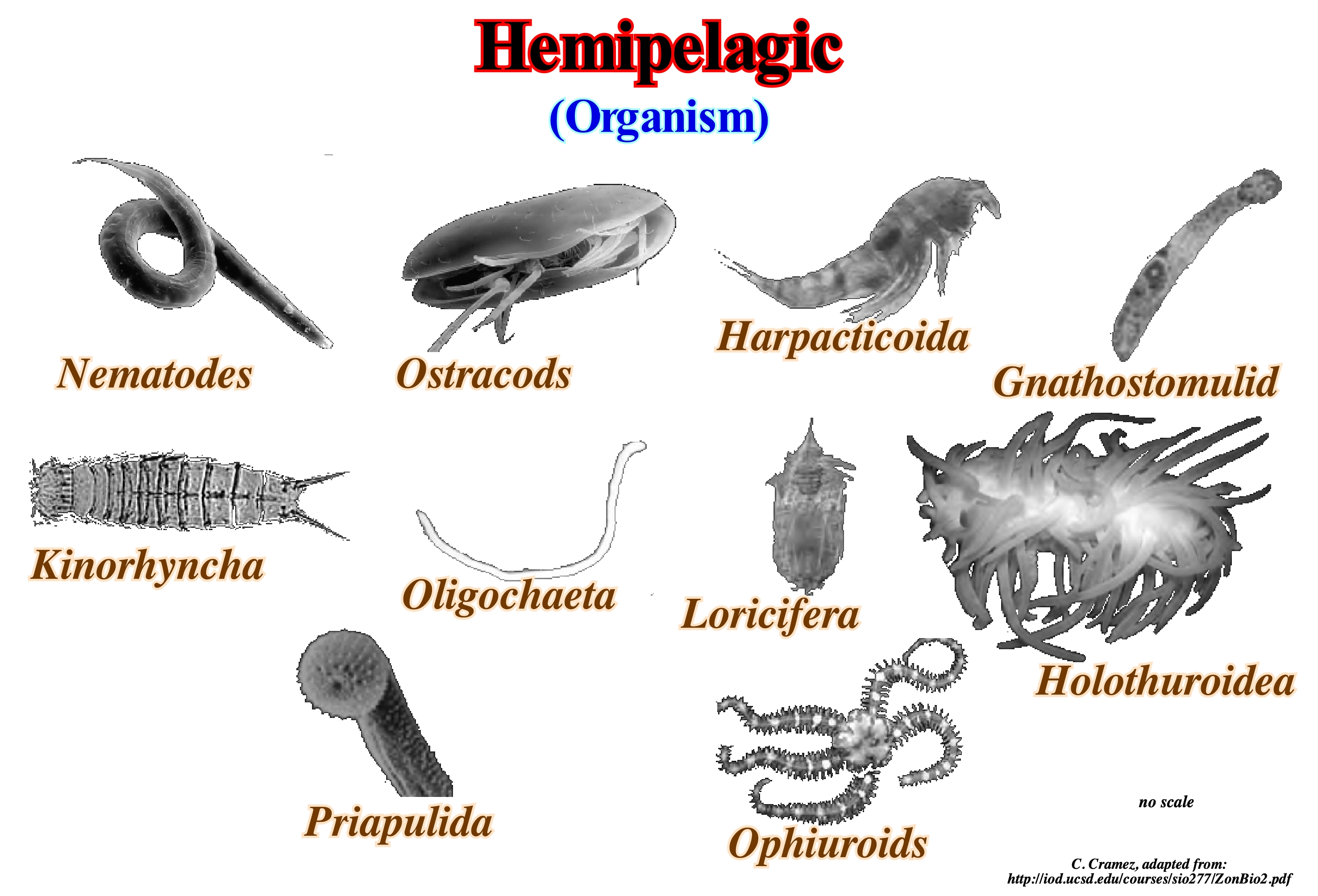
Modern marine sediments are, generally, classified as: (i) Terrigeneous; (ii) Hemipelagic and (iii) Pelagic, function of the distance between the coastline and the sampling site and the lithological characteristics. Similarly, many geoscientists classify organisms according to the environment in which they live: (a) Platform; (b) Hemipelagic and (c) Pelagic. One of the best examples to illustrate the difference between a fauna of a platform environment and hemipelagic is in the Lower Cretaceous in the Mediterranean region. In this region, in the Early Cretaceous, there were large (shallow) carbonate platforms, which passed laterally to very fine sandy sediments and very thick, dark-coloured marls that emphasize anoxic episodes, i.e., without oxygen, which deposited in a hemipelagic environment. The carbonate platforms were colonized by a benthic fauna (which lives near the bottom of the sea), in particular foraminifera, but also calcareous algae, corals, sponges and bivalves, such as rudists. The hemipelagic domain, where the black marls were deposited, provided the habitats indispensable to the ammonites, planktonic foraminifera (that move with the ocean currents, which means that the planktonic beings do not have the capacity of locomotion), that flourished from the Barremian Late, and calcareous nano-fossils. In the ocean, the following habitats can be distinguished: (1) Coastal and Intratidal; (2) Reefal ; (3) Open sea and (4) Deep-water and Trench. The open sea habitat (or wide sea) is immense and is where many species live. Contrary to what many people think, the "open sea" is not the habitat where most species spend their lives. Many species pass through the "open sea" to go to other habitats. They are mainly the larger species that inhabit the "open sea".
Hemipelagic (Sediment)...............................................................................................................................................Hemipélagique (sédiment)
Hemipelágico / Hemipelágico (sedimento) / Hemipelagischen Sediment / 半深海沉积物 / Гемипелагические осадки / Sedimenti hemipelagic /
Transitional marine sediment between fine pelagic and coarse terrigeneous sediments, such as the black vase (marine sediment, of organic origin, abyssal, formed mainly by silica carapace of diatoms, or foraminifera shells). According to some geoscientists, hemi-pelagic sediments have more than 5% biogenic grains and about 40% siltic terrigeneous material. Others think that at least 25% of the hemi-pelagic sediments have dimensions larger than 5 micrometers and that they are of terrigenous, volcanic or neritic origin. In general, hemipelagic sediments deposit near the continental margins.
See : « Sedimentary Environement »
&
« Abyssal »
&
« Basin Floor Fan »
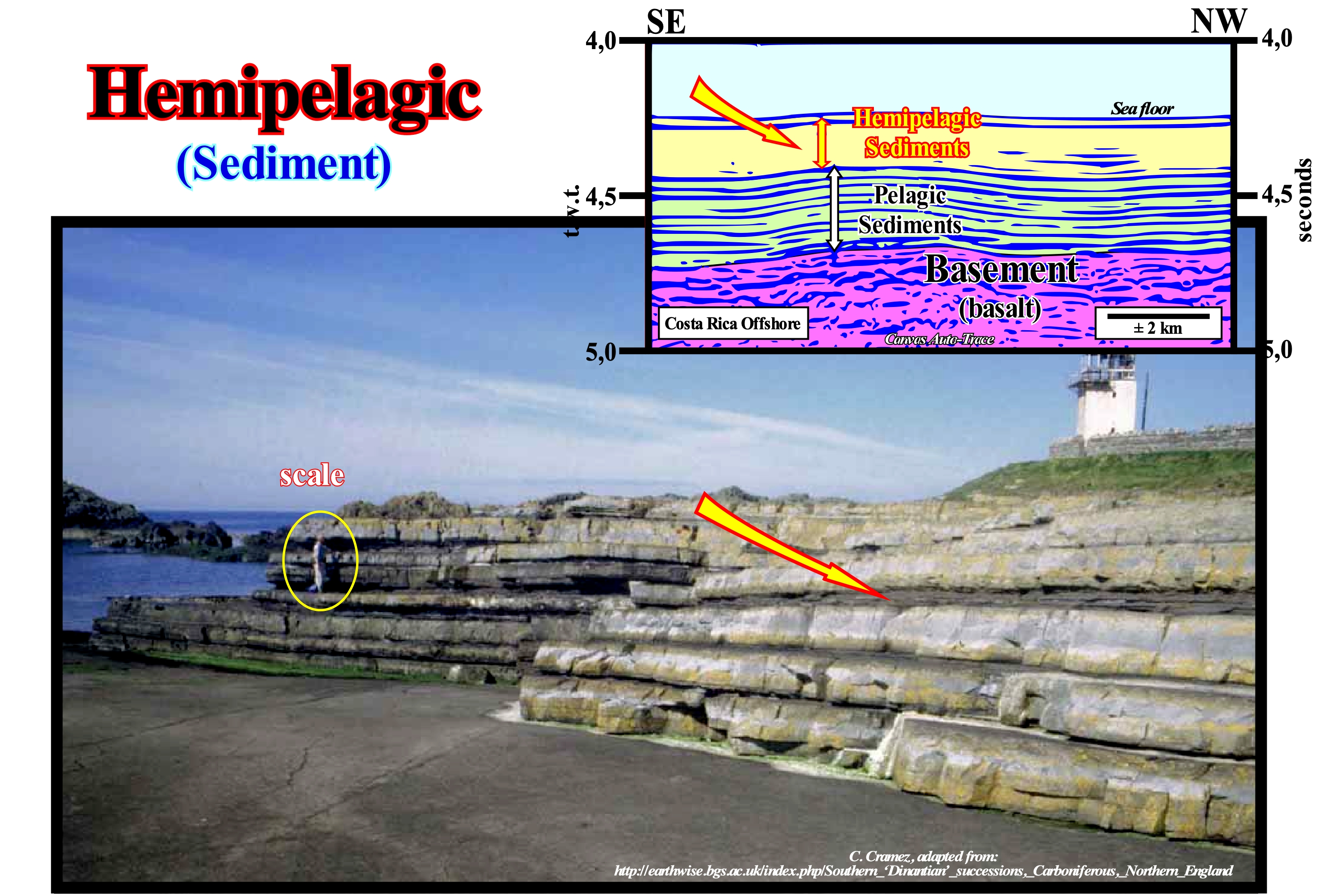
Pelagic sedimentation implies the absence of an influence of terrigeneous sediments. It corresponds to a slow, grain-to-grain, deposition of biochemically produced material in surface waters. Pelagic sedimentation is characterized by numerous hiatus, hardened surfaces, presence of fecal pellets, small-scale laminations, chalk and marl stratification cycles, ripples marks, etc. Hemi-pelagic sedimentation refers to these sediments but with an influence of fine grain material. it is characterized by a re-deposition of sediments by turbidite currents or submarine currents. For some geoscientists, hemi-pelagic sediments are those deposited on the continental shelf and slope. In general, they accumulate quickly, and do not react chemically with sea-water, which allows the grains to retain the characteristics of the areas in which they formed. Hemi-pelagic sediments deposited near reefs contain abundant carbonate material, as well as, those deposited near volcanoes contain many volcanic ash. For other geoscientists, such as Bates & Jackson (1987), a hemipelagic sediment is a deep water sediment containing a small amount of terrigeneous material and pelagic remains. The genesis of hemipelagic sediments is often associated with redeposition processes and includes finer pelitic material from the turbidite streams that spread on the abyssal plain near the continental foothills. As certain geoscientists say, hemi-pelagic deposits are, in fact, impure pelagic deposits. Obviously, it is always useful to specify in what sense the term hemipelagic is used. Unlike the hemi-pelagic sediments, the pelagic ones are deposited in the abyssal plain at a great distance from the continents, that is, away from the gross terrigeneous contributions and turbidity currents, from which the submarine cones of slope and the submarine cones of basin (relatively close to the continents, since the sediments that compose them are of terrigeneous origin). As in these areas, few clastic sediments reach the ocean floor, pelagic deposits are mainly formed by biogenic constituents, such as skeletal remains of marine organisms. When sea surface waters are fertile in radiolaria (single-celled organisms, colonizers of marine and planktonic aquatic habitats, which from the point of view of the food chain are primary herbivores or producers when in symbiotic association with microscopic algae), calcium carbonate (from the foraminifera, coccolithophores algae* and pteropod molluscs (with wing-like appendages for locomotion), opal (diatoms), they can be found in pelagic sediments. In the tentative geological interpretation of a Canvas auto-trace a detail of a the seismic of South Costa Rica offshore, the seismic interval formed by the hemipelagic sediments (upper interval) is much more transparent (practically without reflectors) than the underlying interval, which consists of pelagic sediments deposited above a substrate of basaltic nature, which is nothing other than the oceanic crust. The photograph illustrates the alternation of limestones and shales of the Bowland shaly formation on the Isle of Man (Scarlett Point), which are often considered as hemi-pelagic deposits. In fact, in the Isle of Man and in north of Lancashire, the succession from the Asbian to the Brigantian (in the British stratigraphy**, the Visean is sub-divided into five sub-stages, which from the bottom up: (i) Chadian, (ii) Arundian; (iii) Holkerian, (iv) Asbian and (v) Brigantian is, largely, composed of basal or prodelta facies with black, hemi-pelagic and limestone turbidite intercalations and is included in the shaly formation of Bowland. In the south of the Isle of Man, the lower part of the Asbian of this formation includes the Scarlett Point Member, where the hemi-pelagic clay is interbedded with coarse grain sediments, including large olystoliths of reef carbonate, introduced by chains of turbidity and undersea slides from the platform margin to the north.
(*) They are distinguished from other algae by having a shell consisting of about 30 calcite scales called coccoliths (± 3 μm, 3 × 10⁻⁶ m, 3 micrometers), which are responsible for the deposition of about 1.5 million tonnes of calcite in the oceans each year.
(**) http://earthwise.bgs.ac.uk/index.php/Southern_‘Dinantian’_successions,_Carboniferous,_Northern_England.
(***) Rocky bodies of consolidated sediments, generally large, that lie within a sedimentary succession following a gravitational slide along the continental slope of a sedimentary basin.
Hemipelagite (hypopycnal)....................................................................................................................................................................Hemipélagite
Hemipelagito / Hemipelagito / Hemipelagite (Tiefsee Schlamm) / Hemipelagite(深海泥) / Гемипелагит / Hemipelagite (fango marino profondo) /
Mud deep-sea deposit, in which more than 25% of the fraction of the particles are thicker than 5 microns and that is of terrigeneous, volcanic or neritic origin.
See : « Hypopycnal (flow) »
Heterotrophic (Organism)...............................................................................................................................Hétérotrophique (organisme)
Heterotrófico / Heterotrófico (organismo) / Heterotrophe / 异养 / Гетеротрофный организм / Eterotrofi /
An organism that can not synthesize its own food and is dependent on complex organic substances for nutrition, i.e., it needs organic components based on carbon and nitrogen for its food. The vast majority of animals are heterotrophic.
See: « Photosynthesis »
&
« Autotroph (organism) »
&
« Necrophage »
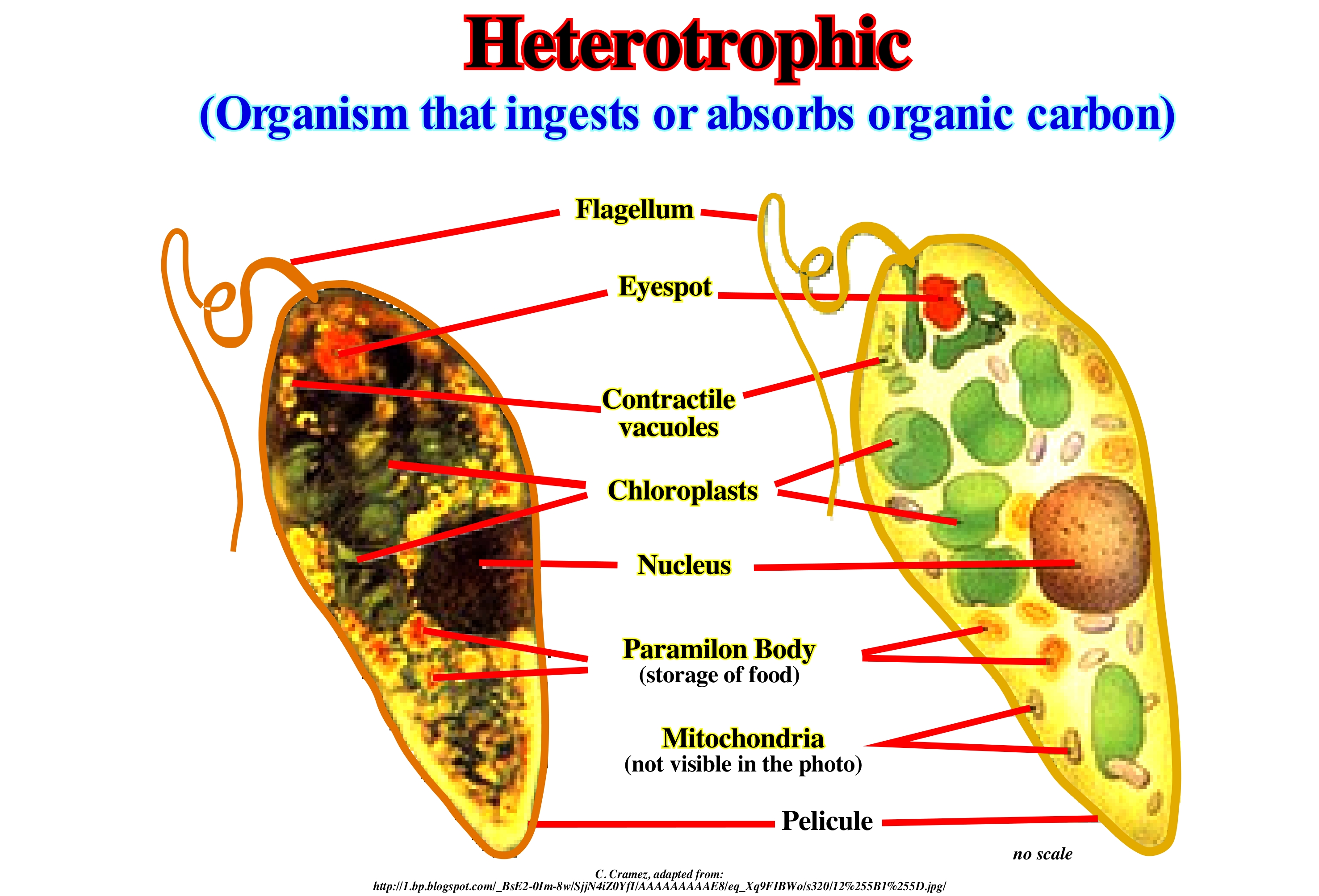
Heterotrophic organisms contrast with autotrophs, such as plants, which can directly use energy sources like sunlight to produce the organic substrates of carbon dioxide. Biologists distinguish two types of heterotrophic organisms: (i) Photoheterotrophs, which derive from the energy of light, the organic carbon and (ii) Chemoheterotrophs that they require an organic source of carbon as a source of energy and to grow. Certain types of bacteria are photo-heterotrophic (the plants are photo-autotrophic rather than heterotrophic). All animals and fungi are chemoheterotrophs. These terms refer to the chemical reactions that are involved in biosynthetic processes or breathing. Phototrophs and chemotrophs which may be either: (i) Lithotrophic or (ii) Organotrophic. Lithotrophs are, in general, bacteria that feed on minerals, often near deep underwater chimneys. Organotrophs feed on organic substances. All animals are organoheterotrophs. All plants are organoautotrophic. Heterotrophic organisms function as consumers in food chains. They get organic carbon by eating other heterotrophic and autotrophic ones. They decompose the complex organic compounds that are produced by autotrophic organisms. In the heterotrophic protozoan illustrated in this figure it is interesting to distinguish: (a) The locomotor flagellum; (ii) The eye spot ; (iii) The contractile vacuoles; (iv) The chloroplasts* ; (v) The nucleus ; (vi) The bodies of Paramilon, where food is stored ; (vii) Pelicule and (vii) Mitochondria**.
(*) Organelles with varied membranes, those of the upper plants being lenticular or ovoid, which are suspended in cytoplasm and which are of great biological importance since photosynthesis is performed there, a function essential in the living world.
(**) Organelles, or organelles, organelles, organelles or organdies, most important cell phones, especially for cellular respiration.
Hiatus................................................................................................................................................................................................................................................................Hiatus
Hiato / Hiato / Hiatus, Pause / 或裂孔 / Разрыв (расщелина) / Iato /
Geological time interval, which at a given location on a stratigraphic surface, is not represented by strata. If the gap covers a significant geological time interval, it may correspond to an unconformity. A hiatus by nondeposit is defined by stratal patterns (onlap, downlap and toplap) in their original positions and characterizes a time interval during which there was no deposit. An erosional hiatus is characterized by truncations. An erosional hiatus characterizes the geological time of the strata that were eroded rather than the age of erosion.
See: « Lateral Sedimentation »
&
« Diastem »
&
« Unconformuîty »
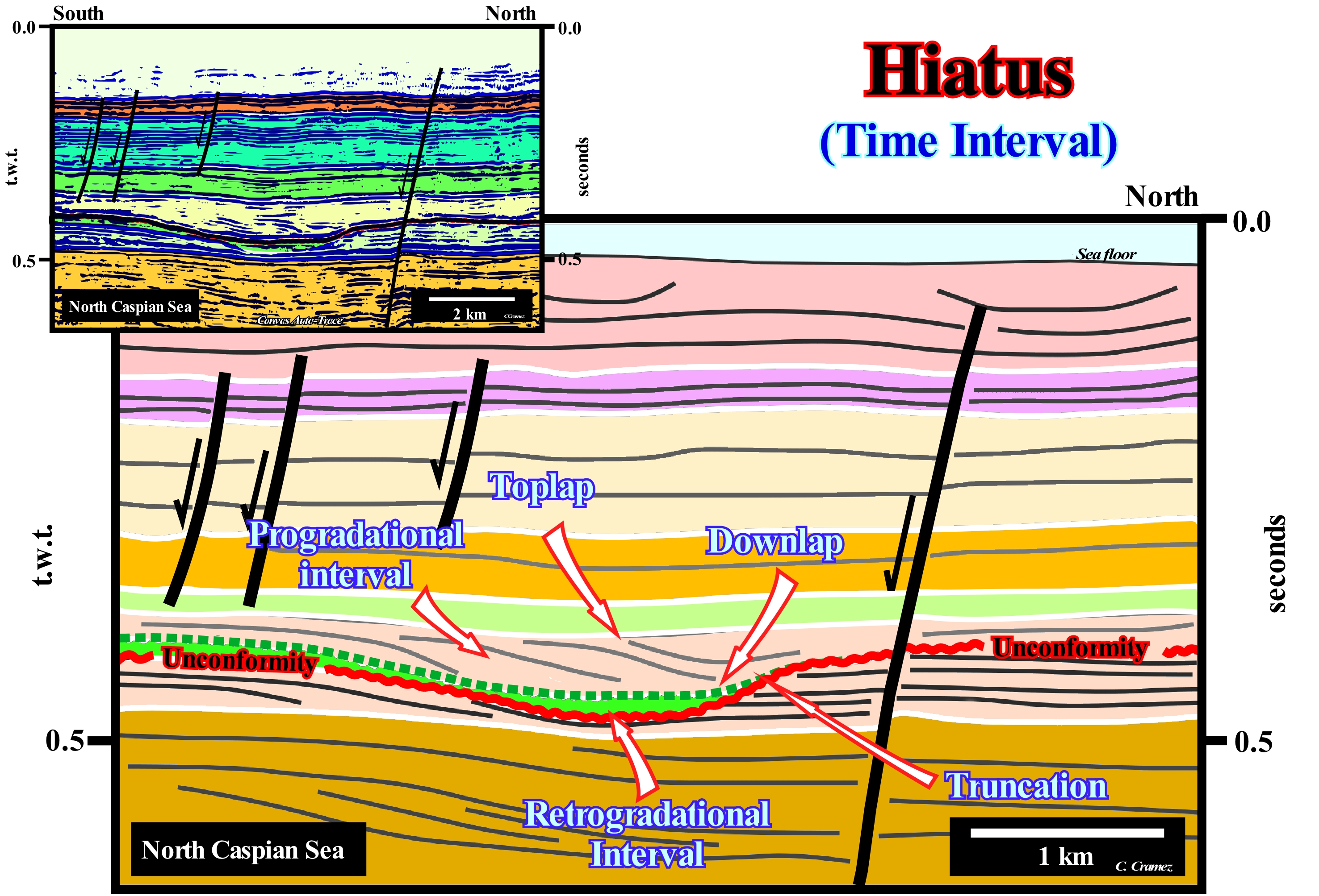
On this tentative geological interpretation of a Canvas auto-trace of a detail of a Caspian Sea seismic line, several types of hiatus can be recognized. In addition to the hiatus associated with the unconformity (underlined in red), which corresponds to an erosional surface induced by a significant relative sea level fall and which separates two stratigraphic cycles, probably sequence-cycles, there are other hiatus, which are not associated with erosion, but with an absence of deposition. On this tentative interpretation, the unconformities (there are several, but just one is coloured in red) are not tectonically enhanced (they separate reflectors, more or less, concordant). They are represented by white coloured horizons except for the unconformities underlined by a red wavy line. The reflectors that this unconformity separates are not parallel to each other. It is the only one (on this auto-trace), in which the associated relative sea level fall is quite evident (underlined by seismic surfaces emphasizing an erosion). Although an unconformity corresponds to an erosional surface, on seismic lines such a surface is, easily, recognized just when it has been enhanced by tectonics or in particular places in which the underlying sediments have been removed by a rejuvenated current. The erosion associated with not enhanced unconformities, which many geoscientists call cryptic unconformities, is just recognized, locally, by : (i) Incised valley fillings, near the basin edge and (II) Submarine canyons fillings near the upper continental slope. Since a geoscientist recognizes, locally, the erosional surface associated with the formation of an incised valley, induced by a significant relative sea level fall, it can, practically, extend it, upstream and downstream, following the first chronostratigraphic line that was not affected by the erosion. Such a surface will be the lower limit of a new stratigraphic cycle. In fact, not only the sediments underlying a incised valley are, partly, eroded, which creates toplaps by truncation, but also the sediments filling show onlapping or downlapping. At the level of the sequence-cycles, near the basin edge, it is, generally, easy to recognize the onlaps of lowstand prograding wedge (LPW) against the sediments of the underlying sequence-cycle (truncation toplaps), that the erosional surface (unconformity) separates. The terminations of the seismic reflectors (lapouts) underlying a submarine canyon emphasize, in most cases, the erosion associated with a relative sea level fall. The same happens with the reflector terminations of the sediments filling the submarine canyon. On this tentative interpretation, for instance, the progradational filling of an incised valley is recognized. The dark green coloured interval is, probably, a transgressive interval, since its geometry seems, globally, to be retrogradational. The incised valley is filled by a progradational interval, which fossilizes a non-depositional hiatus. All this means the incised valley is far from the basin edge. The sediments filling it belong to a lowstand prograding wedge. In fact, when an incised valley is formed near the basin edge, it is, generally, filled at the same time than the upper part of the lowstand prograding wedge (LPW) is deposited. Before of flooding the coastal plain, the sea level (marine ingression) floods the more distal incised valleys. Geoscientists do not forget that a hiatus by erosion corresponds to the geological time of the strata that were removed and not to the time during which erosion occurred. In other words, if in association with a significant relative sea level fall, which occurred during the Late Oligocene, an water-course dug an incised valley within Cretaceous sediments, the erosional hiatus is not Oligocene but Cretaceous. The eroded sediments are of Cretaceous age and not Oligocene. The rocks above a tectonically enhanced unconformity are younger than the rocks below (unless the sequence has been inverted), so it represents the time during which no sediments were preserved in the area. The local record of this time interval can be found in areas where the unconformity is cryptic. Erosion occurs in privileged places along water-courses. The geological time interval not represented is what geoscientists call a hiatus.
Hierarchical Level (Stratigraphic cycles)................................................................................................Niveau hiérarchique
Nível hierárquico / Nivel jerárquico (ciclos estratigráficos) / Hierarchieebene (stratigraphische Zyklen) / 分层级(地层旋回)/ Иерархический уровень (стратиграфических циклов) / Livello gerarchico (cicli stratigrafici) /
One of the four types of stratigraphic cycles that compose sequential stratigraphy, which obeys the theory of hierarchies. A seismic line, for instance, can be interpreted geologically at several hierarchical levels, function of the eustatic cycles considered. Conventionally, four major hierarchies of stratigraphic cycles can be considered: (i) Continental Encroachment Cycles ; (ii) Continental Encroachment Subcycles; (iii) Sequence-Cycles and (iv) Sequence-Paracycles. Sequence-paracycles, as its name suggests, are not stratigraphic cycles, since they are bounded by flooding or ravinment surfaces rather than by unconformities. Sequence-paracycles, which are induced by eustatic paracycles (without relative sea level falls between them), make up the sedimentary systems tracts that constitute the sequence-cycles.
See: « Eustatic Cycle »
&
« Stratigraphic Cycle »
&
« Sequential Stratigraphy »
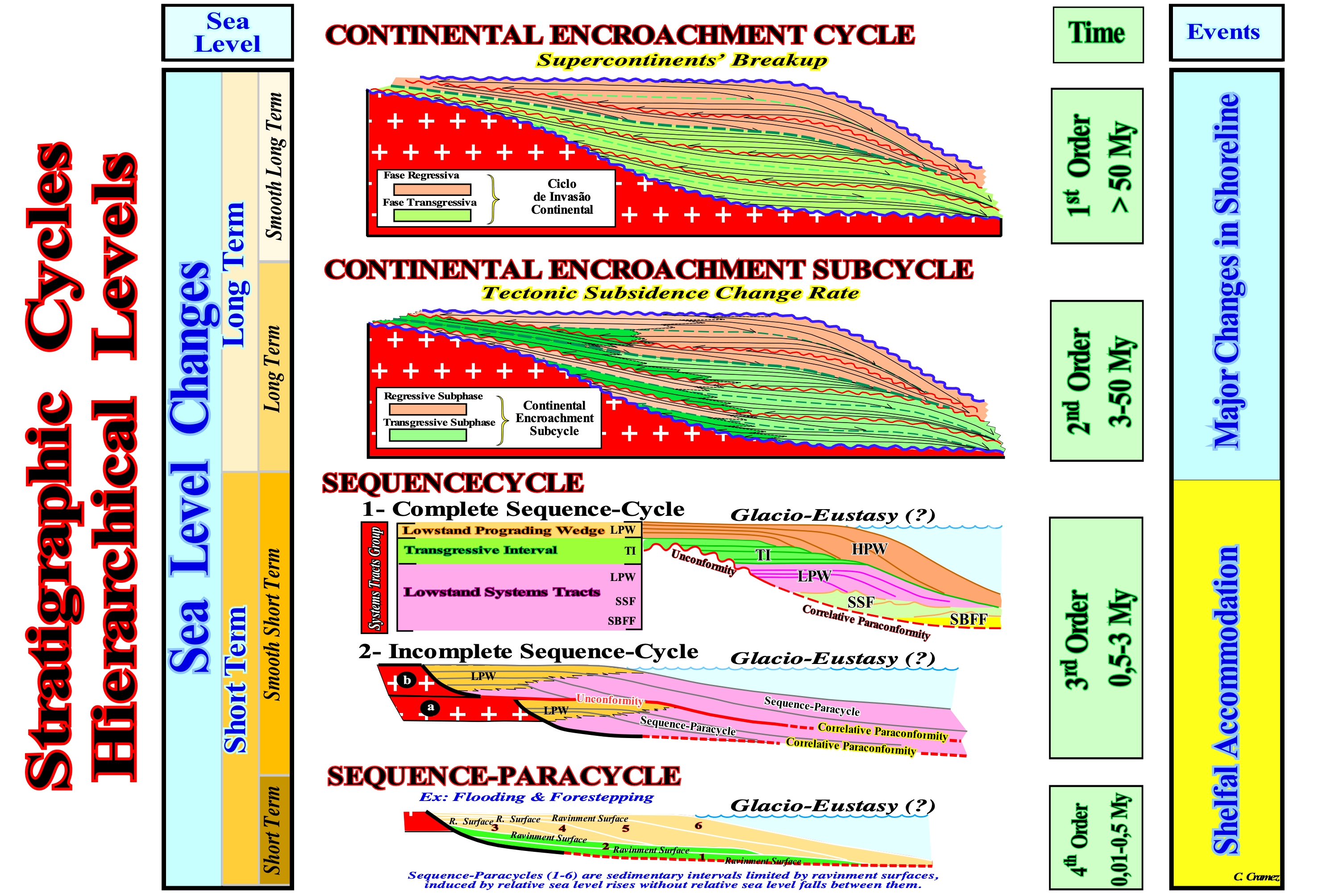
One of the basic principles of sequential stratigraphy is the conjecture that stratigraphic cycles are induced by eustasy* (absolute or eustatic sea level changes, which are supposed to be global and referenced to the Earth’s centre), which is the main responsible of the space created for the sediments to deposit (shelfal accommodation). The hierarchy of stratigraphic cycles depends on the hierarchy of eustatic cycles, which induced them. In general, in the sequential stratigraphy, made from seismic data (taking into account the seismic resolution), three main stratigraphic cycles are considered. They are deposited during 1st, 2nd and 3rd order eustatic cycles, i.e., eustatic cycles with durations, respectively, greater than 50 My, between 50 and 3-5 My, between 3-5 and 0,5 My : (i) Continental Encroachment Cycle ; (ii) Continental Encroachment Subcycle ; (iii) Sequence-Cycles. The continental encroachment cycles are associated with the breakup of supercontinents (Pangea, Protopangea, etc.). Continental encroachment subcycles are associated with tectonic subsidence velocity changes. Sequence-cycles are associated with glacio-eustasy. Sequence-paracycles, induced by eustatic paracycles (time-duration ranging from 0.01 to 0.5 My) are, probably, associated with glacio-eustasy. Eustatic paracycles are characterized by successive relative sea level rises (combined action of absolute or eustatic sea level and tectonics) without any relative sea level fall occurring between them. Between each eustatic paracycle there is stability period of the relative sea level during which the shoreline moves seaward as the deposition occurs. When the relative sea level rises (eustatic paracycle or marine ingression), the shoreline moves continentward, at the same time, that ravinment surface is formed the pre-existent topography. During the stability period of relative sea level following a marine ingression, as the sedimentary particles deposit, more or less, by progradations, the shoreline moves seaward until a new relative sea level displace again the shoreline landward and so on. Sequence-cycles are the building blocks of sequential stratigraphy. It is from the study of these stratigraphic cycles, which are composed by different sedimentary systems tracts, that lithological predictions can be advanced. The terminology presented here is less misleading than the one originally adopted by the Exxon geoscientists (Megasequence, Supersequence, Sequence and Parasequence), since it takes into account one of the basic characteristics of Geology: "All geological interpretation is dependent of the scale". For a long time, certain oil company geoscientists (the first to use sequential stratigraphy) interpreted Exxon's megasequences as "mega" sequence-cycles consisting of "mega" sedimentary systems tracts, which is totally wrong, and that led some geoscientists to predict "mega" turbidites, which the exploration wells have, totally, refuted. This hierarchy means, for instance, that the characteristics of a continental encroachment cycle (of a "whole" as the philosophers would say), can not be defined from the characteristics of the continental encroachment sub-cycles ("parts") that compose them. The "whole" is much more than the sum of the "parts". It is important not to forget that "a part" means anything fragmentary and incomplete, which itself does not have a legitimate existence. An isolated sequence-paracycle does not exist and makes no sense. However, a set of paracycles forms a sedimentary systems tracts and a set of sedimentary systems tracts forms a sequence-cycle. On the other hand, "a whole" is considered as something complete and, by itself, does not require further explanation. But "whole" and "parts" do not exist at all in the domain of geological structures, in the field of sequential stratigraphy, or in the realm of living organisms. What we normally find are intermediate structures at various hierarchical levels in ascending order of complexity. The "Subwhole" show, as we look at them, certain characteristics, generally, attributed to "Parts" (Abraham, 1999).
(*) For many geoscientists, absolute or eustatic sea level changes can neither be global nor uniform. Any cause of sea level also affects the Earth geoid. During the glacial melt defrosting, in response to the load of water added to the ocean basins, the sea level will be depressed, and in response to the removed load (where the ice caps melted), the continent will be lifted. Redistribution of material within the Earth is affected by overload and will force, further, the ocean surface changes (induced by gravity anomalies), and thus further water redistributions will be required to attempt to equalize gravitational potential. This continuous retroactive gravitational process between ice caps, ice seas, glaciers , oceans and the mainland is the process that ultimately determines the signature of the relative sea level, which is observed everywhere the continent and the ocean meet. However, only glacio-eustatic changes are both important (> 10 m) and fast (<1 My).
High Frequence Cycle..............................................................................................................................Cycle de Haute Fréquence
Ciclo de alta frequência / Ciclo de alta frecuencia / High-Frequenz Zyklus / - 频率高周期 / Высокочастотный цикл / Ciclo di alta frequenza /
Stratigraphic cycle induced by a 4th order eustatic cycle, or higher, i.e., an eustatic cycle with a duration of less than 0.5 My (million years). All sequence-cycles when induced by eustatic cycles with a duration of less than 0.5 My are considered as high frequency cycles.
See: « Stratigraphic Cycle »
&
« Eustatic Cycle »
&
« Sequence-Cycle »
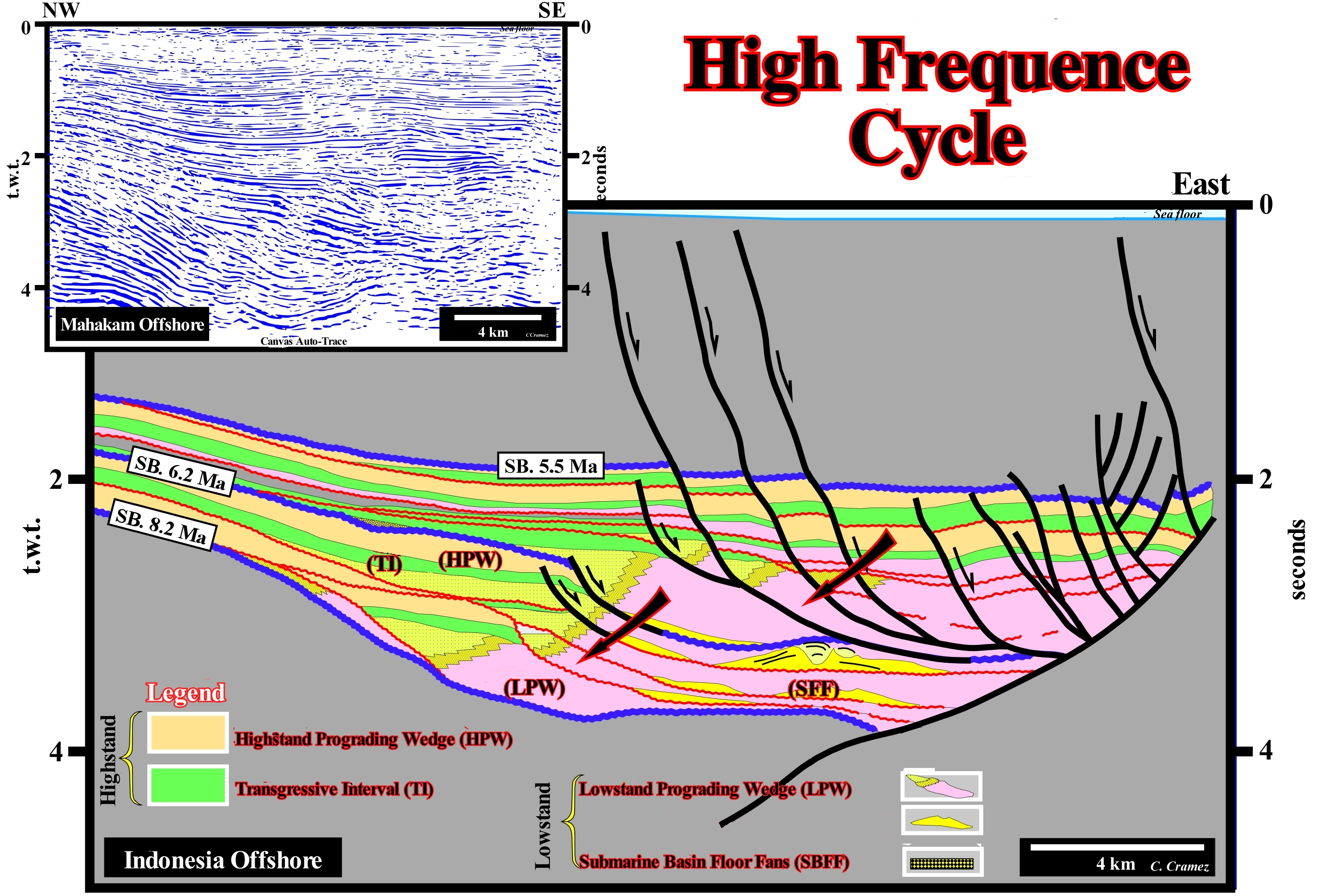
The Indonesia offshore and in particular the Mahakam offshore, in the eastern part of the Borneo island (Indonesia), correspond to the stacking of three types of basins of the classification of the sedimentary basins of Bally and Snelson (1980). On the large regional seismic lines of this offshore, from the bottom up, one recognizes: (i) A Basement or Paleozoic/Mesozoic flattened folded belt (folded and faulted mountain chain) ; (ii) A Mesozoic/Cenozoic backarc basin, in which two tectono-sedimentary phases can be individualized: (a) Rifting or Lengthening Phase and (b) Thermal Phase (cratonic or sag basin of some Anglo-Saxons geoscientists) and (iii) Cenozoic non-Atlantic type divergent continental margin. On this tentative geological interpretation of a Canvas auto-trace of a detail of a seismic line of this offshore (the uninterpreted auto-trace is at the top), it is easy to recognize, within the sequence-cycles* limited by unconformities SB. 5.5 Ma, SB. 6.2 Ma and SB. 8.2 Ma, the high frequency stratigraphic cycles, induced by 4th and 5th order eustatic cycles, whose time-duration is, in principle, less than 0.5 My. Within the SB. 8.2 Ma / SB. 6.2 Ma sequence-cycle, there are five high-frequency stratigraphic cycles. The duration of each of the associated eustatic cycles is difficult to determine, but is, certainly, less than that of a 3rd order eustatic cycle. Some of these high-frequency cycles are incomplete. They are not constituted by the two sedimentary systems tracts groups that, normally, form a sequence-cycle and in which several systems tracts sub-groups are differentiated (from the bottom up): (i) Submarine Basin Floor Fans (SBFF) ; (ii) Submarine Slope Fans (SSF) ; (iii) Lowstand prograding wedge (LPW) ; (iv) Transgressive Interval (IT) ; (iv) Highstand Prograding Wedge (HPW) and sometimes a Bordering Prograding Wedge (BPW). Submarine basin floor fans (SBFF), Submarine slope fans (SSF) and Lowstand prograding wedge (LPW) are the subgroups forming the Lowstand Systems Tracts Group (LSTG). The transgressive interval (TI) and the highstand prograding wedge (HPW) form the highstand systems tracts group (HSTG). In some of the high-frequency cycles illustrated on this tentative interpretation, just two sub-groups of the lowstand systems tracts group were deposited: (a) Lowstand prograding wedge (LPW), where delta systems with associated proximal turbidites (turbidites with a geometry similar to shingled turbidites) and (b) Submarine slope fans (SSF) with well-developed gull-wings structures. Submarine basin floor fans (SBFF) are not recognized. They were, probably, deposited further downstream. The term "high frequency cycle" is used, by convention, for stratigraphic cycles and not for eustatic cycles. For eustatic cycles geoscientists speak in time order. There are at least 5 orders eustatic cycles (time-duration). The 1st order eustatic cycles, in relation to which the continental encroachment stratigraphic cycles are deposited, have a timer-duration greater than 50 My. These cycles are created by the volume variations of the ocean basins induced by the oceanic expansion following the breakup of the supercontinents. The 2nd eustatic cycles, which induce stratigraphic cycles called continental encroachment subcycles, have a time-duration ranging between 3-5 and 50 My. They seem to be induced by variations in the thermal subsidence** of the lithosphere. The 3rd order eustatic cycles, which induce the deposition of the sequence-cycles, have a time-duration between 0.5 and 3-5 My. Eustatic cycles of the 4th and 5th order induce high frequency cycles and last, in general, less than 0.5 My. The 3rd and high-frequence eustatic cycles are defined by changes of relative sea level, i.e., changes of the local sea level referenced to any point on the Earth's surface, which may be the seafloor or the base of the sediments (top of the continental crust). The relative sea level is the result of combined action of absolute (eustatic) sea level changes and tectonics (subsidence or uplift of the sea floor). Absolute sea level is dependent of the glacio-eustasy, induced by changes in the amount of ice, thermal expansion of the oceans or steric sea level rise, tectono-eustasy induced by changes in volume of oceanic ridges and geoidal-eustasy induced changes in isostatic readjustments.
(*) Stratigraphic cycles induced by 3rd order eustatic cycles, whose time-duration, varies between 0.5 and 3-5 My.
(**) Forgetting what is the cause and what is the effect, it can be said that when there is a lengthening of the lithosphere, it becomes slim and the space thus created is filled by the hot asthenosphere, which causes the heating of the crust and a thermal expansion of the its materials. Over time, heat dissipates by radiation from the Earth's surface and the thermal gradient decreases. As the temperature drops, the lithosphere contracts, causing a surface subsidence that may be one of the causes of the second order eustatic cycles. At the scale of the lithosphere (± 100 km), isostatic effects have to be taken into account, since the hot asthenosphere tends to behave like a fluid at the geological time scale.
High Frequency Cycle (Example)........................................................................................Cycle de haute fréquence (Exemple)
Ciclo de alta frequência/ Ciclo de alta frecuencia (ejemplo sísmico)/ High-Frequenz Zyklus / - 频率高周期 / Высокочастотный цикл (сейсмический пример) / Ciclo di alta frequenza /
Stratigraphic cycle induced by an eustatic cycle of 4th order or higher (duration between 0.1 and 0.5 My). Like all other stratigraphic cycles, high frequency cycles are limited by unconformities (erosional surfaces), in shallow environments and, in deep environments, by the correlative paraconformities (non-erosional surfaces), which correlate, upstream, with the unconformities.
See: « Eustatic Cycle »
&
« Glaciation »
&
« Glacio-Eustasy »
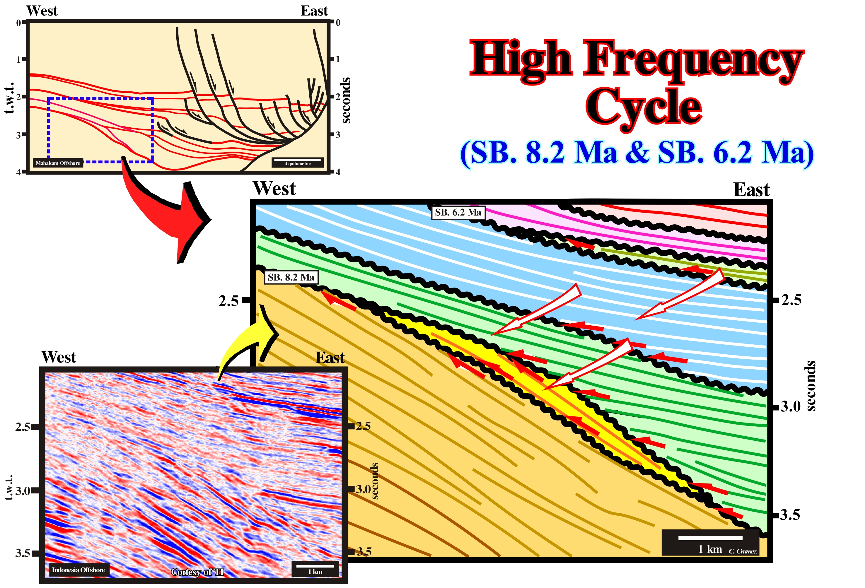
High-frequency stratigraphic cycles should not be confused with sequence-paracycles, although both are induced by 4th or 5th order eustatic cycles or sequence-paracycles. Eustatic paracycles, which induce the sequence-paracycles (periodic), do not imply, practically, any relative sea level fall. They are constituted by successive rises of the relative sea level, which alternate with stability periods. The eustatic cycles that induce high frequency stratigraphic cycles are true cycles. They are separated by relative sea level falls, which are followed by significant relative sea level rises, as illustrated in this detail of a tentative geological interpretation of an Indonesia (offshore East of the island of Borneo) offshore seismic line. On the tentative interpretation the entire seismic line (lower left corner), the basin edge during the Santonian (Upper Middle Miocene) was fossilized by the Messinian (Terminal Miocene) sediments. The unconformity SB. 8.2 Ma is, easily, recognized, not only by toplaps of the underlying interval, but also by onlaps of the overlapping interval. The unconformity SB. 6.2 Ma is easy to recognize. The sediments between these unconformities, whose age difference, determined from the study of the exploration wells along the seismic line, is 2 My, constitute a sequence-cycle, i.e., the associated eustatic cycle has a time-duration between 0.5 and 3-5 My. This sequence-cycle is well-marked in the P. Vail chart of the coastal onlaps. However, between these two unconformities, the lapouts of the reflectors allow to highlight two other unconformities limiting three high frequency cycles. These cycles are, certainly, local and induced by particular geological conditions of this region, reason why they are not marked in the curve of the sea level changes of Peter Vail (chart of the coastal onlaps).
High-Tide............................................................................................................................................................................................................................Marée haute
Enchente (maré-cheia) / Marea alta / Flut, Steigen / 涨潮 / Высокий прилив / Marea montante /
The part of the tidal cycle during which the sea level rises. Synonym with Rising Tide, Flood.
See: « Tide »
&
« Inter-tidal Beach »
&
« Shoreface»
The tide is caused by the gravitational pull of the Sun and the Moon. The influence of the Moon is much higher, because although its mass is much smaller than the Sun, this fact is compensated by the smaller distance to Earth. Mathematically the tide is a sum of sinusoids (constituent waves) whose periodicity is known and depends, exclusively, on astronomical factors. We can say the tide rises during the upper and lower meridian passages of the Moon. There is high-tide when the Moon passes over us and when the Moon passes beneath us, i.e., over our antipodes. The high-tides occur, regularly, with a mean interval of lunar noon (approximately 12h 25m) which corresponds mathematically to the semi-diurnal lunar constituent (M2). This is expressed by the people who state that "the tide, the next day, is an hour later" (in reality ± 50 minutes later). In turn, the time interval between a high-tide and the next low-tide is, on average, 6 h 13 m. The sea does not react, instantaneously, to the passage of the Moon, and for each site there is a greater or lesser delay of the high and low-tides. The time interval between the meridian passage of the Moon and the next high-tide is the so-called lunitidal interval. Watches are, currently, being marketed at which this value is requested, so they can provide a rough tide forecast. Although this value varies over time, in average terms this delay is about 2 hours in Portugal and less than 30 minutes in Madeira and the Azores. Another important aspect to take into account is the biweekly phenomenon of alternation between spring tides tides and neap tides. This phenomenon, mathematically explained by the constituent S2 (solar semidiurne), stems from the effect of the Sun as a "disturbing" element. When the Sun and Moon are in opposition (full moon) or conjunction (new moon), the influence of the Sun reinforces that of the Moon and the spring tides occur (mathematically the constituents add up). When the Sun and Moon are in quadrature (crescent and waning quarter), the influence of the Sun contravenes that of the Moon and the neap tides occur. (http://www.hidrografico.pt/glossario-cientifico-mares.php).
High-Tide Platform (Schore, tidal flat)...............................................Plate-forme de haute-marée, Schorre
Plataforma de preiamar / Plataforma de marea alta, Marjal de marea, Schorre / Plattform hoch-Flut, Schorre / 潮汐滩地 / Приливно-отливная отмель, Шоры / Piattaforma alta-marea, Piatta marea, Schorre /
Part of the pelitic strand that is uncovered in the neap tides and covered of water during the spring tides and storms. The term platform is misused here. Synonym with Schorre.
See: « Beach »
&
« Inner Neritic »
&
« Shelf »
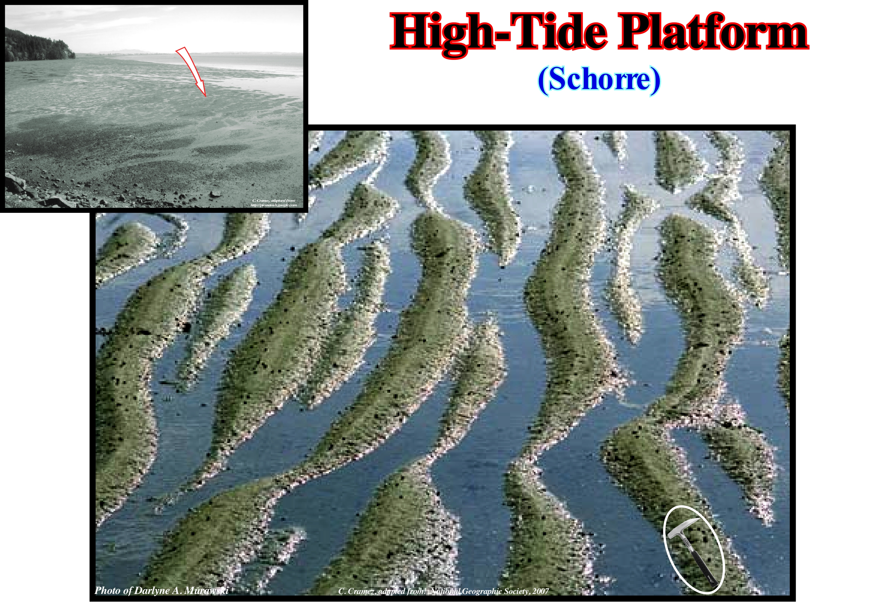
The high-tide platform is a shaly surface, consolidated surface and covered by a halohydromorph soil (temporarily or permanently saturated by an excess of salt water). Such a surface is often cut into convex islets by tidal channels, with pools and completely colonized by halohelophyte vegetation (rooted in the salty mud). The vegetation covering a high-tide platform can is herbaceous in the extratropical (Marshland) and shrub and or arboreal in intertropical (mangrove) regions. The high-tide platform or schorre is separated from the lower part of the strand by a step that can reach a few meters and corresponds to the step of the high-tide. From the ecological point of view, the main function of a high-tide platform (schorre or tidal-flat) is the conversion of plant biomass (usually in the form of debris) into animal biomass, which can be used by organisms with a higher trophic level,i.e., by organisms of the ecosystem with a more refined food. The presence on the high-tide platform of a whole set of coastal environments is very important, not only for the birds that inhabit the coast, but also for the birds of passage. The Laguna Madre high-tide platform (Texas, USA) represents a suitable habitat between the warm-growing habitats of the north and the distant habitats of South America for the birds of migration and hibernation. Most bird mortality is due to lack of resources during winter and migration areas. The invertebrates of the high-tide platforms provide, without a doubt, an abundant food source for the birds. When the tidal flats are totally flooded, the adjacent beaches may be a second or alternative source of food. The continent and adjacent habitats can be used as passage and feeding residences. The tidal flats are sources of nitrogen to the ecosystem, since the blue algae from the high-tide platform convert the atmospheric nitrogen into nitrogen that can be used by other plants. In the morphology of the high-tide platform (tidal flats or schorre) and downstream of the dunes and above the soft tidal flat channels and tide pools can be recognized. The whole of high-tide and low-tide platform is called marsh by many geoscientists. They consider it to be an ecosystem of great importance, since it plays a preponderant role in the equilibrium of the organic matter cycle from the perspective of primary producers. There are two types of marsh, one fluvial and one marine. The marine marsh consists of a diversity of anastomosed tidal channels, which alternate with small substrate rises. This region that has a certain regularity in the environmental conditions and in the animal and vegetal populations, is under the influence of several natural environmental factors. At the low-tide platform, biomass is abundant (up to several thousand organisms per square meter during low tide in temperate zones, at least 60 species of fish and crustaceans that feed all or part of their life there). During low-tide, there are thousands of birds that come there looking for molluscs or macro-zoobentos. In general, all geoscientists admit (http://www.ecosociosystemes.fr/ schorre.html) that the coastal waters of Europe are characterized by a very marked dichotomy: downstream of the high-tide platform (schorre) and upstream of the lower mud-flat (slikke). On the other hand, almost all geoscientists agree that: 1) Lower mud-flat or low-tide platform is characterized by halophilic vegetation (adapted to salt) that is distributed by floors ; (2) The lower part lower mud-flat is covered at every tide, except during neap tides and is colonized by plants such as soda (Suaeda maritima) and sea aster (Aster Tripolium) ; 3) The middle part of the lower mud-flat has a thick vegetation due to the obione (Portulacoides Obione) ; 4) The high part of lower tide-flat is composed of fennel (Salicornia sp.), Spartina (Spartina) and (Atropis), sea lavender (Limonium) or artemisia (Artemisia vulgaris) ; 5) The schorre is the part of the mud flat that is covered only when the great tides ; 6) The slikke is composed mainly of soft muds of smooth appearance and without vegetation, it contains a great quantity of bacteria that allow it to play an essential paper in the processes of assimilation and recycling of dead organic matter ; 7) The slikke shelters a variety of bivalve species (clams, cockles, etc.), small gastropods, green crabs and (mullet, squares, bars) ; 8) The slikke is frequented by species of waders, that is, that live in the mud (torches, knights, snipe, tailor), herons and other seagulls with black head and seagulls, chestnuts or mariners, but also by many terrestrial and marine invertebrates, like spiders (Lycosidae / Pardosa purbeckensis?), that since the tide is installed run on the surface of the water, to hunt prey, but also to find partners.
Highstand (Sea level)......................................................................................................................................................................Haut niveau (De la mer)
Nível Alto (do mar) / Nivel alto (del mar) / Höchststand, Über dem Meeresspiegel / 高位, 海拔 / Высокий уровень моря / Highstand, Alto livello del mare /
Time interval, within an eustatic cycle, during which the sea level is above the basin edge. At the beginning of a sequence-cycle (stratigraphic cycle), the reference basin edge is the last edge of the highstand prograduing wedge (HPW) of the underlying sequence-cycle. Since this edge is fossilized by the first sediments of the transgressive interval (TI), the new basin edge is the edge coasral plain of the lowstand prograding wedge (LPW).
See: « Sequence-Cycle »
&
« Lowstand (sea level) »
&
« Relative Sea Level Change »
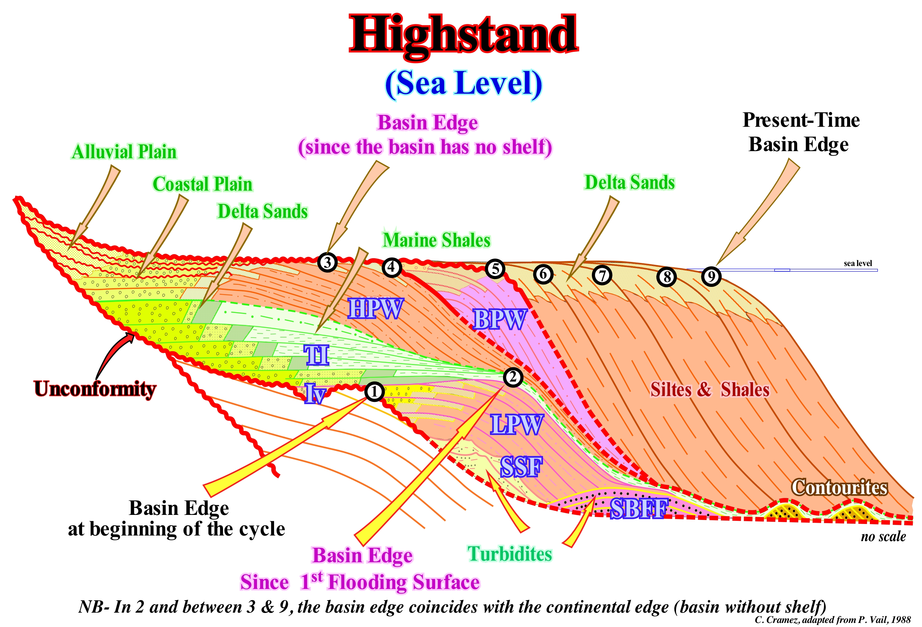
In this stratigraphic model (without scale), a sequence-cycle induced by a 3rd order eustatic cycle (time-duration between 0.5 and 3-5 My) is represented. The lower limit is a type I unconformity, since the relative sea level* fall below the edge of the highstand prograding wedge (HPW) of the underlying cycle. This unconformity is characterized by the terminations of the chronostratigraphic lines and the presence of the incised valleys fills (Iv). A type II inconformity (induced by an insufficient relative sea level fall to put the sea level is below the basin edge) is visible in the upper part of the cycle. This type II unconformity allowed the deposition of a bordering prograding wedge (BPW), which some geoscientists call the prograding bordering platform. Over time, geoscientists have realized that type II unconformities are either very rare or do not exist, especially when sequential stratigraphy is done on seismic data, which certain geoscientists call seismostratigraphy. At present, geoscientists prefer to speak of forced regressions which, in large part, correspond to the descending sedimentary systems tracts of P. Vail, which are nothing other than the bordering prograding wedges. Within a complete sequence-cycle, from bottom to top, two groups of sedimentary systems tracts may be evidenced: (i) Lowstand Systems Tracts Group (LSTG) and (ii) Highstand Systems Tracts Group (HSTG). Within the lowstand systems tracts group, three sub-groups of systems tracts are considered: (a) Submarine Basin Floor Fans (SBFF), with a planar or mounded geometry with contourites **, often, associated ; (b) Submarine Slope Fans (SSF), whose geometry is, more or less, mounded, with structures in gull wings structures and (C) Lowstand Prograding Wedge (LPW) with its typical progradational geometry. The highstand systems tracts group (HSTG) is composed of two sub-groups: (1) Transgressive interval (TI), characterized by an overall retrogradational geometry created by a succession of increasingly important marine ingression that induce sedimentary regressions increasingly smaller and (2) Highstand Prograding Wedge (HPW), which as the lowstand prograding wedge has a well-marked progradational geometry due to a succession of increasingly smaller marine ingressions that induce sedimentary regressions increasingly important. In the early days of sequential stratigraphy, a bordering prograding wedge (BPW) was, sometimes, considered in association with the highstand prograding wedge. Today, geoscientists talk, mainly, on forced regression. During the three sub-groups of lowstand systems tracts, i.e., during the submarine basin floor fans (SBFF), submarine slope fans (SSF) and lowstand prograding wedge (LPW), the geological conditions are lowstand. The sea level is, always, lower than the basin edge (the last continental edge of the highstand prograding wedge of the underlying sequence-cycle). From the moment that the sea level floods the coastal plain of the lowstand prograding wedge (LPW), i.e., since the first transgressive surface the geological conditions change and the transgressive interval (IT) of the highstand systems tracts starts to deposit. The basin has a new edge (the last continental edge of the lowstand prograding wedge), which is maintained until the progradation of the highstand prograding wedge (HPW) fossilize it and creates a new basin edge, much higher, corresponding roughly to the shoreline (the basin has no more shelf). At the hierarchical level of the sequence-cycles, when the sea level is high, the basin almost always has a continental shelf (platform), except during the 2nd stage of development of the highstand prograding wedge (HPW), since the shoreline coincides with the continental edge (at least seismically, i.e., taking into account the seismic resolution). During the deposit of the lowstand systems tracts group (LSTG), the basin has no shelf. All systems tracts subgroups deposit on the abyssal plain or onlap the continental slope (the basin edge is the last continental edge of the preceding sequence-cycle).
(*) Sea level local and referenced to the base of the sediments or the sea floor seabed and which is the result of the combined action of tectonics (subsidence or uplift of the sea floor) and absolute (eustatic) sea level, which is referenced to the Earth's centre.
(**) Deep-water deposits associated with submarine basin floor fans and, genetically, induced by contour currents created by the Coriolis force. Lithographically, the contourites are formed by thick packets of fine sand (without clay matrix), with progradational geometry and an ascending slope (climbing toplaps). Some geoscientists, such as Bouma, have called the contourites the deep-sea structures (channels filled by a lateral terrigeneous influx), found in the Swiss flysch, which are characterized by a significant abundance of heavy minerals such as zircon, allanite, etc.
Hinterland Sequence Cycle......................................................................................................Cycle séquence nonmarin
Ciclo sequência não-marinho / Ciclo secuencia no-marino / Hinterland - Sequenz Zyklus / 腹地序列周期 / Цикл тылового комплекса / Ciclo sequenza non-marine /
Sequence-cycle consisting entirely of non-marine deposits deposited upstream of the shoreline where deposition mechanisms are controlled indirectly or independently of sea level position (mainly upstream of the bayline).
See: « Stratigraphic Cycle »
&
« Sequence-Cycle »
&
« Bay-line »
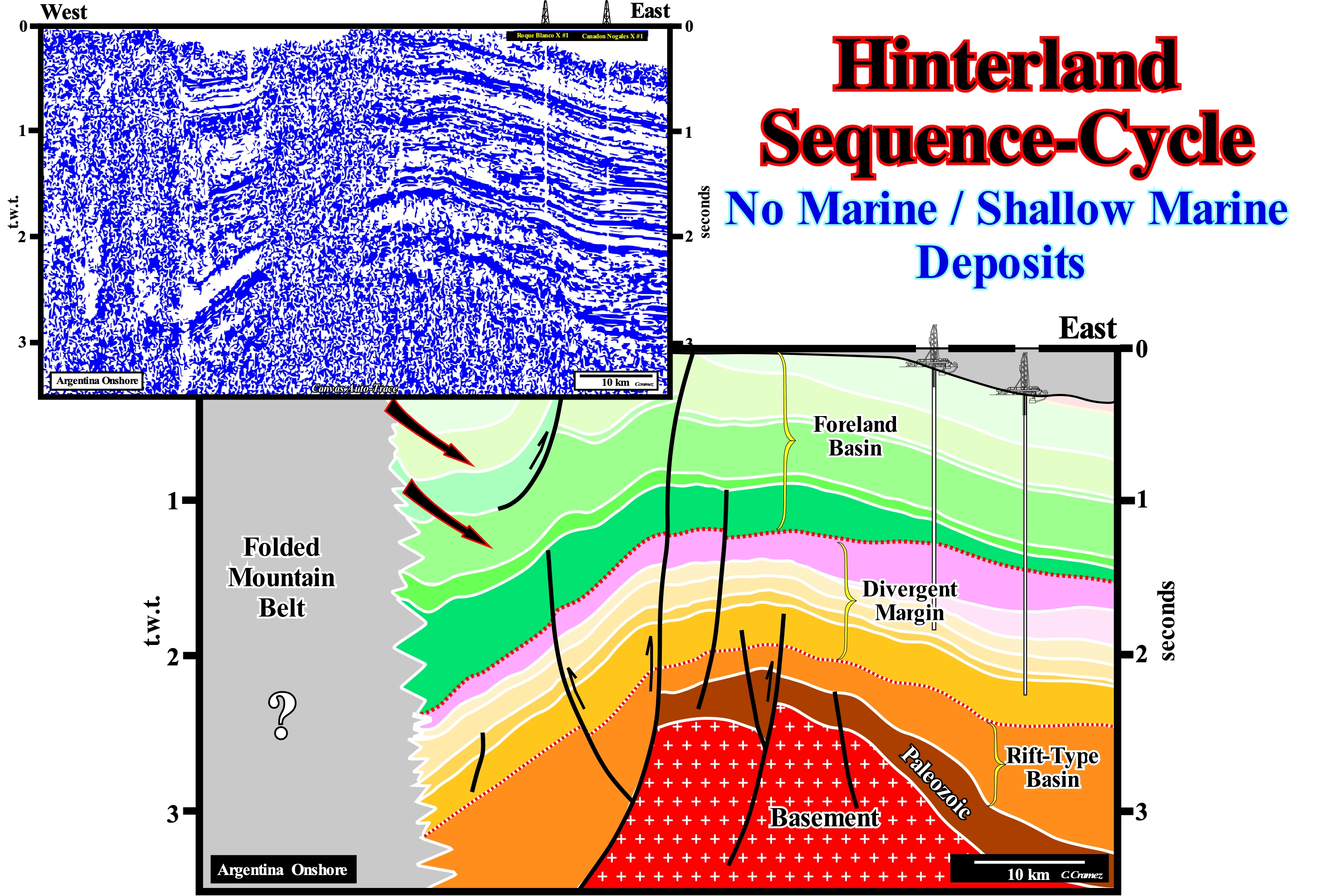
On this tentative geological interpretation of a Canvas auto-trace of a seismic line of the Neuquen geographic basin, located in the Argentina onshore, it is easy to see this onshore is constituted by the stacking of several types of sedimentary basins of different ages. Using the classification of the sedimentary basins proposed by Bally and Snelson (1980), it is possible recognize above a granitic basement (probably of Precambrian age): (i) A Paleozoic Folded Belt serving as substratum (coloured, on this tentative interpretation, in dark brown) ; (ii) Two Triassic (orange-coloured) rift-type (halfgrabens) basins ; (iii) A Early Mesozoic Divergent Margin (coloured in light brown and violet tones) ; (iv) A Cretaceous Foreland or Foredeep Basin (coloured in green) and (v) A Mountain Folded Belt, which on this tentative interpretation is no taken into account. All these sedimentary basins are individualized by unconformities, which many geoscientists call angular unconformities. In reality, they are just tectonically enhanced unconformities, i.e., erosional surfaces induced by significant relative sea level falls, which put the sea level lower than the basin edge, when the basin has a shelf, or lower than the continental edge, when the basin has no shelf. This is particularly obvious for the unconformity marking the base of the foredeep basin, underlined on this tentative interpretation by a red dashed line. Most of the sedimentary packages that form the foreland basin, which probably correspond to a continental encroachment subcycles (induced or associated with second order eustatic cycles) were deposited in nonmarine environments. The accommodation (space available for the sediments) was, mainly, created by subsidence of the sea floor. Probably, tectonics (shortening and lengthening) was the main parameter of the creation of available space for sediments. Eustasy (absolute or eustatic sea level changes) determined the cyclicity of eustatic cycles, i.e., eustasy that caused and localized the unconformities. In the foreland basin, the sequence-cycles, which may, eventually, be highlighted, are nonmarine. The predominant tectonic regimes were not only compressive, but the overload and migration of the thrust and the reverse faults sipping eastward were preponderant. In this type of sedimentary basin and contrary to what happens in all other basins, the rate of tectonic pulsations is, sometimes, faster than the rate of absolute (eustatic) sea level changes (sea level referenced to a terrestrial point which is, usually, the Earth's centre). In other words, in some foreland basins, not only the space available for sediment (shelfal accommodation), but also the sedimentary cyclicity can be controlled mainly by tectonics and not by absolute sea level changes (eustasy). From the relative sea level changes, which is the result of the combination of the absolute sea level and tectonics, geoscientists can determine not only the accommodation but also the temporal position of the unconformities and the different sedimentary systems tracts forming a cycle-sequence. On this tentative interpretation, at the beginning of the foreland basin, the source of the terrigeneous influx was at East, i.e., from the craton, but, to the extent of the sedimentary shortening, which implies, necessarily, an uplift, the terrigeneous influx coming from West became, progressively, preponderant. This tentative interpretation suggests not only that the normal faults bordering the half-grabens of the rift-type basins were probably controlled by Paleozoic fracture zones but also that a large part of the shortening of the foreland basin (eastward of the mountain range) is the result of the reactivation of the old normal faults, limiting Paleozoic paleo-highs and bordering the Triassic rift-type basins, in reverse faults. The tectonic inversion is quite significant, but it was not total. The null point is not located in the lower sector of the fault planes of reactivated faults but mainly in the middle sector **.
(*) Sea level referenced to any point on the land surface, which may be the sea floor or the top of the continental crust.
(**) Above the null point the fault has an inverse fault geometry, whereas below the null point the fault maintains its original normal fault geometry even though the vertical throw has decreased.
Highstand Deposit.................................................................................................................................Dépôt de haut niveau (De la mer)
Depósito de nível alto (do mar) / Depósito de nivel alto (del mar) / Anzahlung auf hohem Niveau (meer) / 存款高级别(海) / Отложение в условиях высокого уровня моря / Deposito di alto livello (mare) /
Sediments deposited in the coastal plain, platform, continental slope, or even in the abyssal plain, when the sea level is higher than the basin edge and when the equilibrium point and the bay-line are upstream of the depositional coastal break. Since the bay-line and the equilibrium point are downstream of the basin edge, the deposits are lowstand type. In a sequence-cycle, the highstand system tract group is formed by two sub-groups: (i) Transgressive interval (TI) and (ii) Highstand prograding Wedge (HPW). The transgressive interval (TI) is deposited when the 1st and 2nd derivative of the relative sea level curve (function) are positive, which means that the function (curve) is crescent with a concave geometry or, in other words, that the rate of relative sea level rise is in acceleration. In turn, the highstand prograding wedge is deposited when the curve is crescent with a convex geometry (1st derivative positive and 2nd derivative negative), which emphasizes a relative sea level rise in deceleration.
See: « Lowstand Deposit »
&
« Relative Sea Level Change »
&
« Highstand »
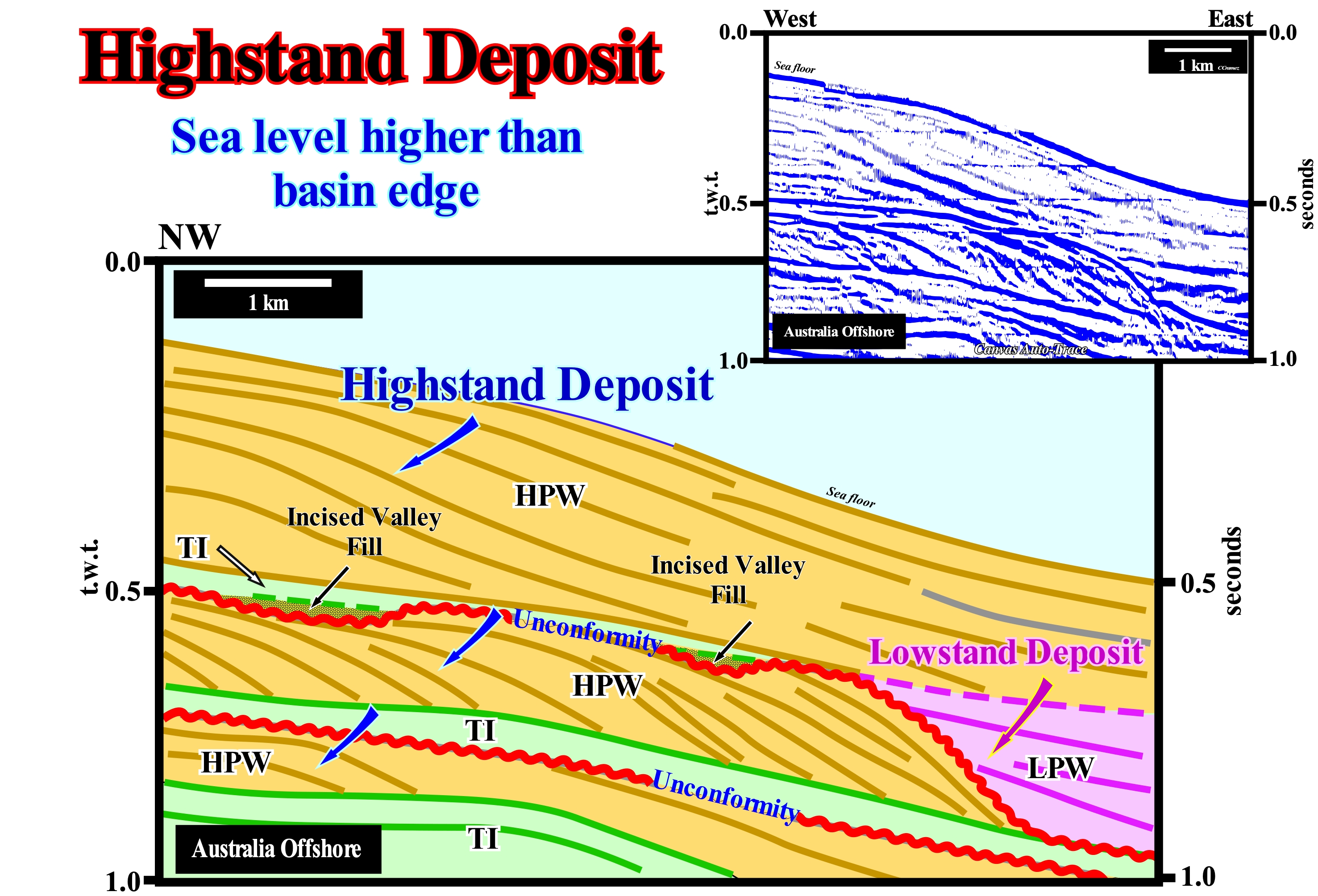
On this tentative geological interpretation of a Canvas auto-trace of a detail of an Australia offshore seismic line, three incomplete sequence-cycles, induced by three 3rd order eustatic cycles (time-duration less than 3-5 My) are obvious. These stratigraphic cycles are separated by unconformities, which are recognized without great difficulty by the reflector terminations: (i) Onlaps and (ii) Toplaps by truncation. With the exception of the lowstand prograding wedge (LPW) of the most recent sequence-cycle (coloured in violet), which is visible in the lower right corner of this tentative interpretation, and the incised valley fills, which underline the basal unconformity of the upper sequence-cycle, all stems tracts sub-groups, visible on this line, were deposited in highstand conditions. In other words, they were deposited when the level of the sea was higher than the basin edge (not to be confused with continental edge although, for sometimes they may be more or less coincident). On this tentative interpretation, transgressive intervals (TI) and highstand prograding wedges (HPW) are predominant. The transgressive intervals (TI), which are deposited in association with relative sea level rise in acceleration, have an overall retrogradational geometry and a parallel internal configuration. They correspond to sedimentary transgressions. Geoscientists call sedimentary transgressions or simply transgressions a the set of increasingly important marine ingressions and increasingly smaller sedimentary regressions. It such a set of marine ingressions and sedimentary regressions that, collectively, create a geometry, globally, retrogradational of coastal onlaps. On the other hand, it must always be borne in mind that during each incremental rise (eustatic paracycle), in acceleration of the relative sea level, there is no deposition but just a seaward displacement of the shoreline. At same time time that in the pre-existing topography a small ravinment surface is formed due to the erosive action of the sea-waves. The sequence-paracycle deposition of the sequence-paracycle takes place during the stability period of relative sea level (local sea level referenced to the sea floor or to the base of the sediment) that occurs after each marine ingression as the shoreline moves seaward. The sediments settle down along chronostratigraphic lines, more or less, progradational, since the sedimentary particles come always from the continent (remobilizations by coastal currents excluded). Highstand prograding wedges (HPW), which are deposited in association with relative sea level rises in deceleration*, have a progradational geometry and an internal sigmoid configuration (significant upbuilding, albeit small, in relation to outbuilding, as in the upper sequence-cycle) or oblique (insignificant upbuilding, as in the intermediate sequence-cycle). The downlap surface that separates the transgressive interval (TI) from the overlying highstand prograding wedge (LPW), corresponds to a boundary between two geometries: a) Progradational ; b) Aggradational. The progradational geometry overlies the aggradational geometry. Each sequence-paracycle forming the transgressive interval (IT) has a well-marked progradational geometry. It is more correct to say that the geometry of the transgressive interval is retrogradational, since it corresponds to a vertical succession of progradational sequence-paracycles smaller and smaller. A transgressive set is nothing more than a succession of smaller and smaller regressions. Many geoscientists group the transgressive interval and the highstand prograding wedge into a highstand systems tracts group (HSTG), to emphasize the fact that these deposits are highstand. Although the incised valleys are located upstream of the continental edge, their filling is done during lowstand geological conditions. In fact, the filling is synchronous with the upper deposits of the lowstand prograding wedge (LPW). That taking into account the vertical scale and the angle of the progradations, the predominant facies of these sequence cycles is probably carbonated.
(*) As in transgressive intervals (TI), the deposition of the sequence-paracycles that form the systems tract called highstand prograding wedge (HPW), takes place during stability periods of relative sea level, which occurs after each marine ingression which in this case are increasingly smaller, since the relative sea level rise in deceleration (reason why the ravinment surfaces are much rarer at the base of these sequence-paracycles).
Highstand Prograding Wedge (1st phase)...........................................Prisme de haut niveau (1ère phase)
Prisma de nível alto (1a fase) / Prisma de alto nivel (1ª fase) / Highstand progradierende Keil (1 Phase) / 高位prograding楔(1 期)/ Prograding клин высокого стояния (первая фаза) / Prisma alto livello (1° fase) /
When the depositional coastal break (more or less the shoreline) is individualized from the continental edge that coincides with the basin edge or, in other words, when in a sequence-cycle (SC), the highstand prograding wedge (HPW) has a shelf, which corresponds to its first phase of development.
See : « Systems Tract »
Highstand Prograding Wedge (2nd phase)........................................Prisme de haut niveau (2ème phase)
Prisma de nível alto (2a fase) / Prisma de alto nivel (2ª fase) / Highstand progradierende Keil (2 Phase) / 高位prograding楔(2 期)/ Prograding клин высокого стояния (2 фаза) / Prisma alto livello (2° fase) /
When the depositional coastal break, which corresponds more or less to the shoreline) coincides (at least on seismic lines, taking into account the seismic resolution) with the continental edge or, in other words, when the highstand prograding wedge has no continental shelf, which corresponds to its 2nd phase of development.
See : « Systems Tract »
Highstand Systems Tracts (Group)......................................................................Cortége de Haut Niveau (De la mer)
Cortejo de nível alto / Cortejo de nivel alto (del mar) / Prozession der High - Level (Sea) / 高层次的游行(海) / Тракт системы высокого уровня моря / Processione di alto livello (mare) /
One of the systems tract forming the set of the transgressive interval (TI) and the highstand prograding wedge (HPW), which are sub-groups of the group of highstand systems tract (HST). Within a complete sequence-cycle, the group of highstand systems tract is formed by two sub-groups: (i) Transgressive interval (TI) and (ii) Highstand prograding wedge (HPW). The highstand prograding wedge is deposited when the sea level is above the basin edge and when the relative sea level rises in deceleration, near the stabilization, or even when it begins to fall. The transgressive interval (TI) is deposited when the relative sea level rises in acceleration. In the curve of available space during a sequence-cycle, the segments during which the lowstand prograding wedge (LPW) and the transgressive interval (TI) are deposited have the 1st and 2nd derivatives positives (the function, i.e., the curve is crescent with a concave geometry, which means that the rate of relative sea level rise is in acceleration). The segment during which the highstand prograding wedge (HPW) is deposited has the 1st derivative positive, but the 2nd derivative is negative (the function is crescent with a convex geometry or, in other words, the rate of sea level rise is in deceleration). The deposition occurs during the period of relative sea level stability following each of the eustatic paracycles.
See : « Systems Tract »
&
« Sequential Stratigraphy »
&
« Highstand »
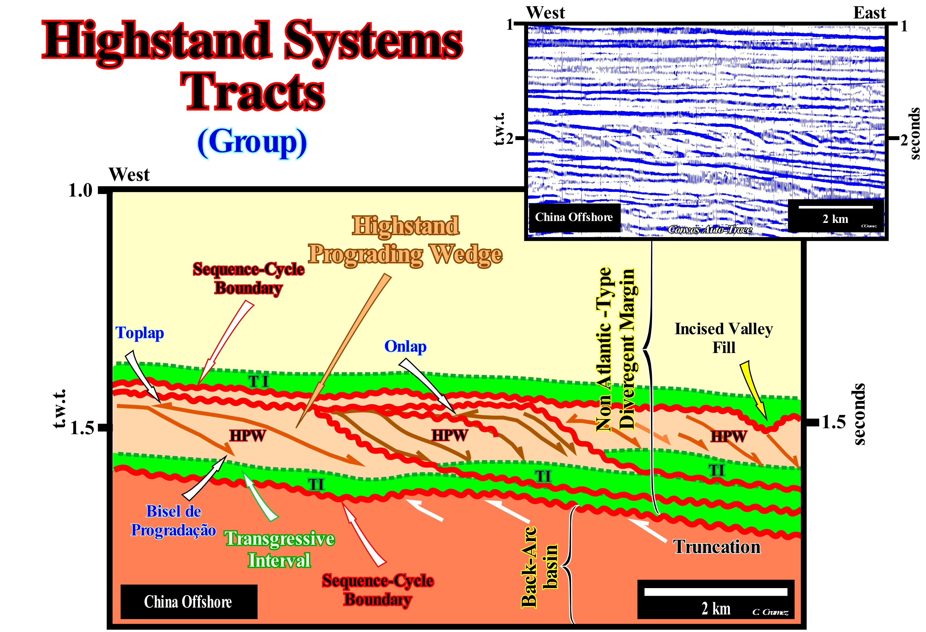
The China offshore, where the original seismic line of the Canvas auto-trace, shown in this figure, was shot, corresponds to the stacking of several basins of the sedimentary basin classification of Bally and Snelson (1980). In the vast majority of offshore regional seismic lines of this area, from the bottom to top, it is, easy, to recognize: (i) A Basement or a Folded Belt, more or less, flattened ; (ii) A Mesozoic/Cenozoic Back-arc Basin and (iii) A non Atlantic-type Divergent Margin, that developed in association with the oceanic expansion that occurred after the break-up of the backarc basin. On this tentative geological interpretation of a detail of the auto-trace of seismic line of this offshore, in non Atlantic-type divergent margin, it is possible to recognize the distal parts of several sequence-cycles. Each of these stratigraphic cycles, induced by an eustatic cycle (curve of the relative sea level changes), whose time-duration varies between 0.5 and 3-5 My, is bounded by two unconformities, i.e., by two erosional surfaces created by significant relative sea-level* falls. The age difference between two consecutive unconformities (red wavy lines on this tentative interpretation) is less than 3-5 Ma and greater than 0.5 My. The lower unconformity of each sequence-cycle is identified by the geometric truncation relations of the reflectors of the underlying sequence-cycle. The upper unconformity is, easily, recognized not only by the coastal onlaps of the overlying sequence-cycle, but by the toplaps of the highstand prograding wedge (HPW) as well. On this tentative interpretation, the last dotted unconformity (more or less, at a depth of 1.4 seconds, double time) is recognized by the occurrence of an incised valley filling. Within each sequence-cycle, only the systems tracts sub-groups of the highstand group are visible, i.e.: (i) The transgressive interval sub-group (TI), which is limited between the lower unconformity and maximum flooding surface (in dashed and coloured in green), and (ii) The highstand prograding wedge sub-group (HPW), that is, easily, recognized by its progradational geometry contrasting with the aggradational geometry of the transgressive interval (IT), which at large-scale is retrogradational. In order to avoid confusion, we prefer to use "highstand prograding wedge" to denominate the systems tract sub-group (HPW) and use the expression "highstand systems tract" to denominate the systems tracts group (HSTG). The transgressive interval (TI) sub-group belongs, also, to the high systems tract group (HSTG) as the highstand prograding wedge (HPW) . During transgressive intervals (TI), the relative sea level rises in acceleration, while during the deposition of the highstand prograding wedge (HPW), the relative sea level rises in deceleration. In other words, the marine ingression increments, which create the available space for sediments (accommodation), are increasingly important during the transgressive intervals and increasingly smaller during the highstand prograding wedges**. On the other hand, during the transgressive intervals, the sequence-paracycles are increasingly smaller, whereas during the highstand prograding wedges, they are increasingly important. The limit between the relative sea level rise in acceleration and in deceleration corresponds, more or less, to the inflection point of the curve of the relative sea level changes. It emphasizes the maximum flooding surface. The first flooding surface of the coastal plain (in lowstand geological conditions the basin has no shelf) marks the beginning of the transgressive interval (IT) and the instauration of a shelf (continental platform). The extent of the continental encroachments depends on the morphology of the lower unconformity (pre-existent topography). For the same relative sea level rise, the less seaward slopping is the lower unconformity, the greater is the continental encroachment (continentward displacement of the shoreline and associated coastal deposits).
(*) Local sea level referenced to any point on the Earth's surface, whether the sea floor or the base of the sediment. It is the result of the combination of absolute (eustatic) sea level, i.e., of the global sea level referenced to the Earth's centre, and tectonics (subsidence or uplift). Subsidence when the predominant tectonic regime is in extension, that is, when the sediment are lengthened or uplift, when the predominant tectonic regime is in compression, i.e., when the sediments are shortened.
(**) During the deposition of the lowstand prograding wedge (LPW), the marine ingressions, i.e., the relative sea level rises are also in acceleration. The associated segment on the relative sea level curve (eustatic cycle) is crescent with a concave geometry.
Hjulström Diagram........................................................................................................................................Diagramme de Hjulström
Diagrama de Hjulstrom / Diagrama de Hjulström / Hjulström - Diagramm / 尤尔斯特伦图 / Диаграмма Хелстрома / Curva di Hjulström /
Graph used in hydrology to determine if a river erodes, transports or deposits the particles and, for that, it takes into account the size of the sedimentary particles.
See: « River »
&
« Fluvial Deposition »
&
« Transportation (sediments) »
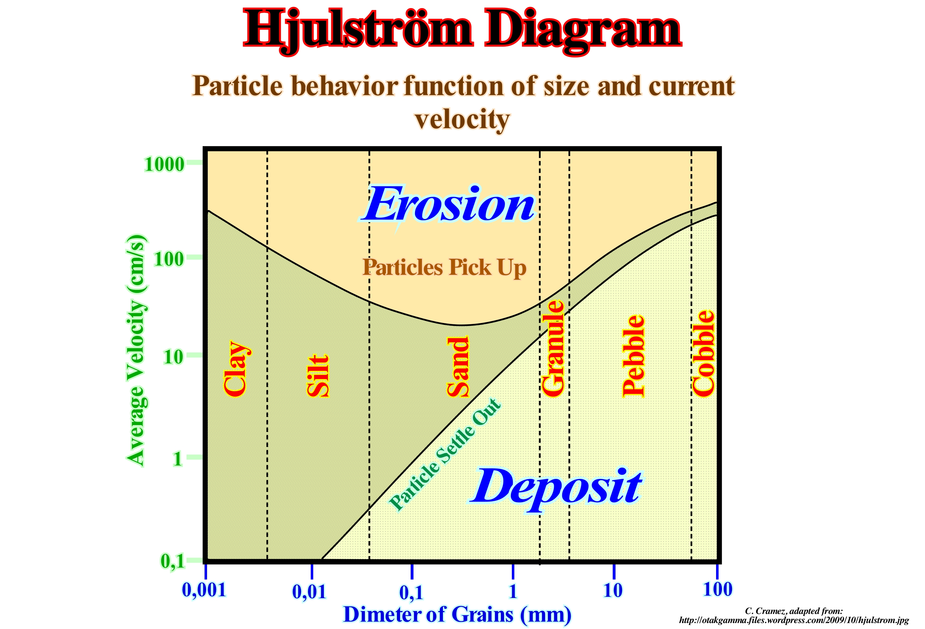
As can be seen in this figure, the Hjulström diagram takes into account the size of the sediments (abscissa axis) and the flow velocity of the water stream (ordinate axes). The scale on both axes is logarithmic*. The upper curve indicates the critical erosion velocity in centimeters per second (cm/s) as a function of particle size, which is expressed in millimeters. The lower curve indicates the rate of deposition as a function of particle size. This diagram describes several key concepts on the relationships between erosion, transport and deposition. In the right part of the diagram, that is, when the particle size is large (cobble, pebble, granule) or, in other words, when the friction is the dominant force that prevents erosion, the two curves are, more or less, parallel and relatively close one of the other, which means that the required velocity increases with the size of the particles. In the left part of the diagram, where the sedimentary particles are more cohesive (clay and silt) the erosion velocity increases as the particle size decreases, since the cohesion forces are, relatively, more important when the particles are more small. The critical velocity for deposition depends on the rate of sedimentation, which decreases with decreasing grain size. This diagram shows that sand particles having a size around 1 mm require a lower water stream flow rate to erode. All this means that the larger the particle size, the higher the flow velocity has to be, so that they can erode (in general, the bed of the stream) and that they settle down even when the flow velocity is significant. In contrast, when the particle size is small, practically, they do not settle even when the flow velocity is small. They just erode when the flow velocity is important. In other words, the maximum erosion for a minimum flow velocity is made by sedimentary particles having dimensions between 0.1 and 1 millimeters, that is, by the sands.
(*) A logarithmic scale is a measurement scale that uses the logarithm of a physical quantity instead of the quantity itself. In mathematics, the logarithm of base "b" of a strictly positive real number is the power at which the base "b" must be raised to obtain this number. A simple example of logarithmic scale shows divisions equally spaced on the vertical axis of a graph marked with 1, 10, 100, 1000, ... instead of 0, 1, 2, 3, ...


Send E-mails to carloscramez@gmail.com or to carlos.cramez@bluewin.ch with comments and suggestions to improve this glossary.
Copyright © 2009 CCramez, Switzerland
Last updated: August, 2019