

Prodelta...............................................................................................................................................................................................................................................Prodelta
Prodelta / Prodelta / Prodelta / 前三角洲 / Продельта / Prodelta /
Part of the delta that is below the effective depth of the erosion of the waves (in calm sea). The prodelta is located beyond the delta front and slopes to the deep part of the basin into which the delta progrades and where the clastic sediments transported by the current are no longer preponderant.
See: « Systems Tract »
&
« Delta »
&
« Delta Plain »
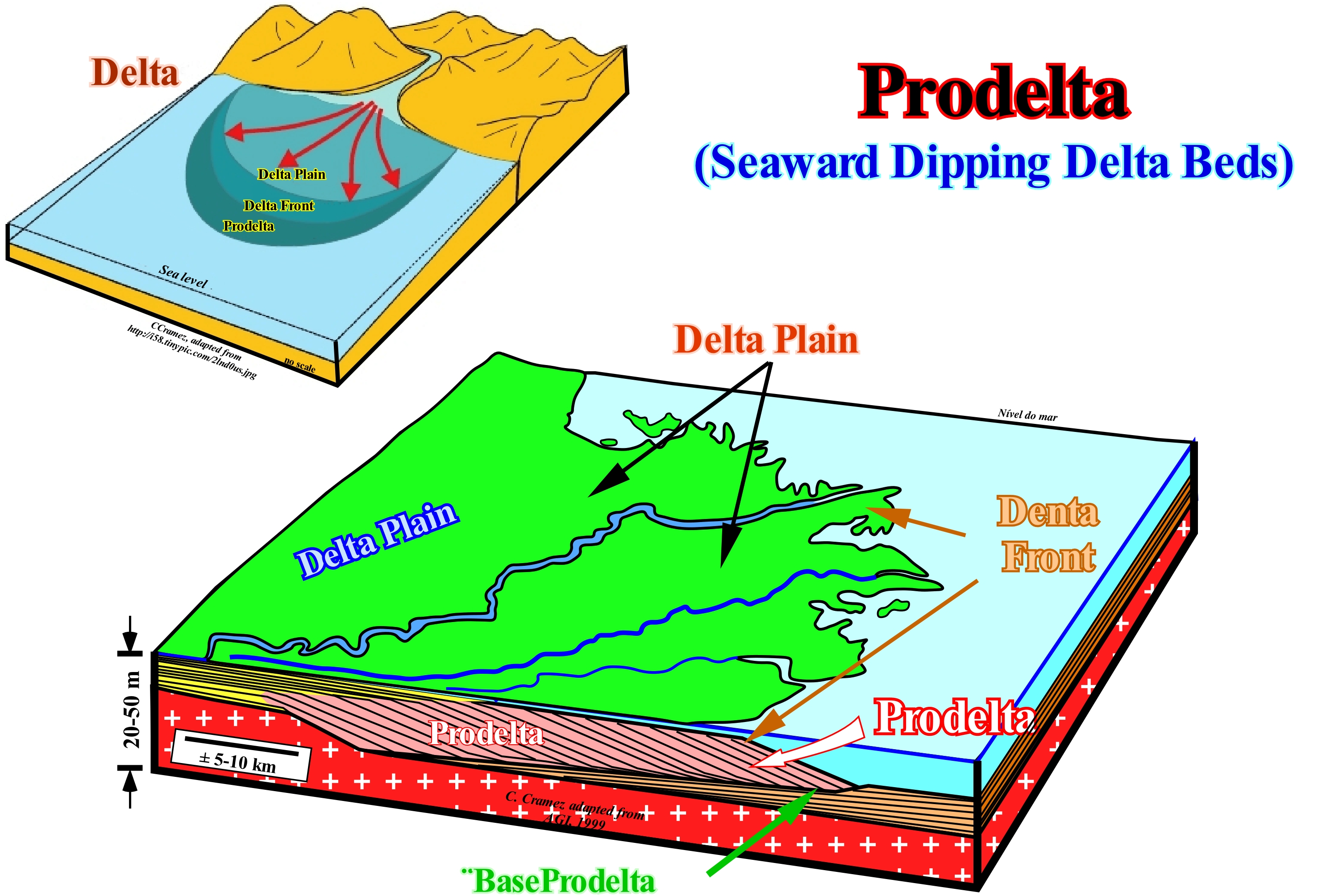
A delta is a sedimentary deposit, more or less, sub-horizontal, located in the mouth of a river and that has, generally, a triangular or fan-shaped morphology. A delta is crossed by numerous distributive rivers that, sometimes, extend seaward of the shoreline. When the mouth of a river is in a lake, lacustrine deltas are formed, which are as frequent as the marine deltas. A delta results from the accumulation of the terrigeneous influx carried by a current, which is not removed by tides, waves or marine currents. Three major sedimentary environments can be recognized in a delta: (i) Delta plain ; (ii) Delta front ; (iii) Prodelta and (iv) Prodelta Base. The delta plain, which is the upper part of the delta, where the, more or less, horizontal upper layers are deposited and which ends in delta front, which is the proximal part of the delta where the sandy sediments are deposited. The prodelta is the part of the delta that is, generally, under the erosive action of the waves and where the sloping or frontal canyons fills are deposited. At the base of the prodelta, lower horizontal layers are, often, deposited. Proximal submarine turbidite fans can be deposited , there. It is important not to confuse a delta with a delta building, which happens, very often, on tentative geological interpretation of the seismic lines. In the same way that a skyscraper is the vertical stacking of a set of floors whose average height is 2.40 m, a delta building is the, more or less, vertical stacking of deltas whose average thickness varies between 30 and 60 meters (this means that in most cases the thickness of a delta is lower than the seismic resolution). The thickness of a delta building can exceed 5-10 km, whereas the thickness of a delta, rarely, exceeds 60 meters. A prodelta or delta slope can not be confused with a continental slope. Although, in certain cases, when the basin has no continental platform (shelf), the upper continental slope may be formed by a delta slope. Thus, in this figure is not illustrated a delta, but a delta building. A delta is formed by the lateral association of several depositional systems or facies, i.e., by different lithologies with a fauna, more or less, characteristic deposited in sedimentary environments, more or less typical. A delta is a sedimentary systems tract, in which from the continent seaward, the following facies are, generally, recognized: (i) Delta plain silts; (ii) Delta front sandstone ; (iii) Prodelta shales and (iv) Basal prodelta shales with or without sandstone layers (proximal turbidites). All these facies or depositional systems are synchronous and linked, genetically, although in particular cases the upper and lower layers may be absent, which is not the case of the seaward dipping prodelta layers. A delta is induced by an eustatic paracycle, i.e., by a relative sea level rise, which is nothing other than marine ingression, which displaces the shoreline continentward, increases the space available for sediments (accommodation). This available space thus formed is filled during the stability period of relative sea level that occurs after an eustatic paracycle (there are no relative sea level falls between eustatic paracycles) as the shoreline line moves seaward. The fills of the available space, i.e., the deposition is, usuall,y made by sigmoid progradations (when the upper and lower horizontal layers of the delta are present) or by oblique progradations (when only the dipping layers of the delta have deposited). However, all intermediate cases are possible. In the sequential stratigraphy made from field observations, at the level of a sequence-cycle, it can be said a delta is a paracycle of a sequence-cycle, induced by an eustatic paracycle, either in a context of accelerating marine ingressions (marine ingressions increasingly important), that is, in association with a transgressive interval (TI), or in a context of decelerating marine ingression, that is, in association with highstand prograding wedge (HPW). In seismostratigraphy, taking into account the seismic resolution, most of the time, in a sequence-paracycle there area several sedimentary systems tracts (several deltas, in this particular case) and it is for this reason that geoscientists working with seismic data consider subgroups and groups of sedimentary systems tracts and not just sedimentary systems tracts as the geoscientists who work in the field.
Producer (Organism)......................................................................................................................................................................Producteur (Organisme)
Productor / Productor (organismo) / Produzent (Lebewesen) / 製作人(众生) / Продуцент (организм) / Produttore (essere vivente) /
Organism capable of synthesizing its own food from inorganic substances using sunlight or chemical energy. Green plants, algae and certain bacteria are autotrophic organisms. Synonym with Autotrophic.
See: « Autotroph (organism) »
&
« Algae »
&
« Euphotic Zone »
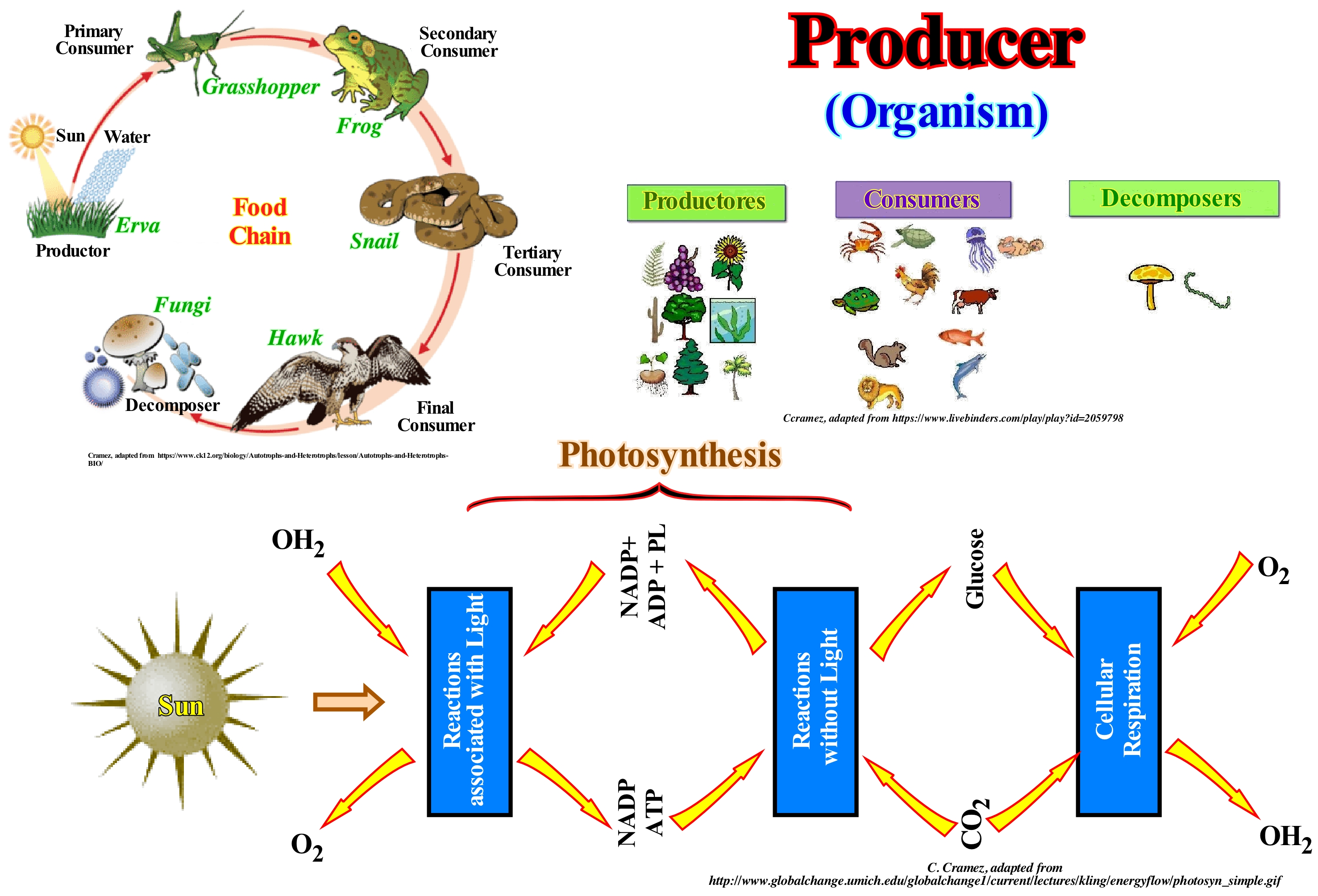
An autotroph, also called a producer, is an organism that produces complex organic compounds (such as carbohydrates, fats and proteins) from simple inorganic molecules using light energy (by photosynthesis) or inorganic chemical reactions (chemosynthesis). They are the producers of the food chain, such as plants in the ground or algae in the water. Producers are able to make their own food and can fix the carbon. They do not use organic compounds as a source of energy or as a source of carbon. Autotroph organisms can reduce carbon dioxide (by adding hydrogen) to make the organic compounds. Reducing carbon dioxide, a low-energy compound, creates a store of chemical energy. Most autotrophs use water as a reducing agent, but others can use hydrogen compounds, such as hydrogen sulfide. A producer can produce his own energy through photosynthesis via the inputs of light, carbon dioxide and water. Producers or autotrophs may be phototrophs or lithotrophs (chemoautotrophs). Phototrophs use light as a source of energy, while lithotrophs oxidizer inorganic compounds such as hydrogen sulfide, elemental sulfur, ammonia (NH4), iron oxide (FeO), etc. Lithotrophic phototrophs use a portion of ATP (Adenosine-5 triphosphate) produced during photosynthesis or oxidation of inorganic compounds to reduce NADP (Nicotinamide adenine dinucleotide phosphate) plus a NADPH to form organic compounds. Other organisms, called heterotrophs, use autotrophs as food to perform the functions necessary for their life. The heterotrophs, that is, all animals, almost all fungi, as well as the vast majority of bacteria and protozoa, depend on the autotrophs for the energy and raw materials they need. Heterotrophic cells derive energy from the breakdown of organic molecules (carbohydrates, fats and proteins) contained in food.
Proglacial Lake.......................................................................................................................................................................................Lac proglaciaire
Lago pró-glaciário / Lago proglaciar / Eisstausee / Proglacial湖 / Прогляциальное озеро / Lago proglaciale /
When the dam of the lake is formed by a moraine or by the ice of a glacier in phase of thinning (retrogradation). Lake formed by the melting water retained against an ice cap due to the isostatic depression of the crust created around the ice.
See: « Lake »
&
« Glacier »
&
« Depositional Environment »
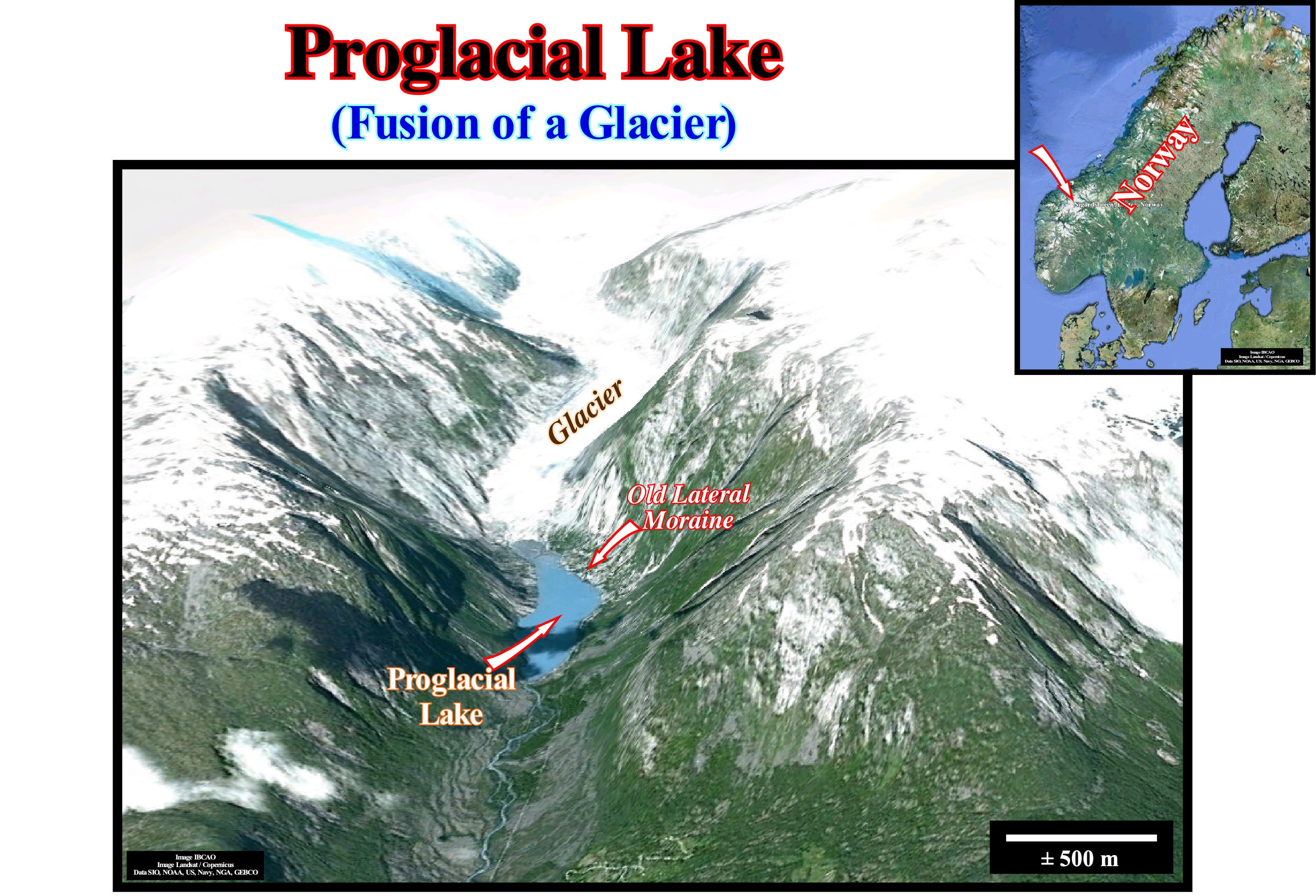
At the end of the last "Ice Age" (a period of geological time during which a prolonged drop in temperature of the surface and atmosphere of the Earth causes expansion of glaciers and glaciers), i.e., roughly 10,000 years ago, large proglacial lakes formed in the northern hemisphere. Even today, in association with the thinning (retreating to certain geoscientists) of the glaciers induced by the end of the Little Glacial Age (16th century until the middle of the 19th century), proglacial lakes are formed, as illustrated in this photograph (taken in 1987, this is before the so-called global warming that would have started according to certain geoscientists in 1990). Indeed, during the 1930s the rapid thinning of the Nigardsbreen glacier in Norway uncovered a rocky depression which was filled by the melting water of the glacier creating a proglacial lake. The lateral moraine of an ancient thinning phase of the glacier is visible above the lake (right corner of the photograph). Despite the presence of numerous proglacial lakes in Europe, such as: (i) Komi Lake ; (ii) Baltic Lake ; (iii) Ancylus Lake ; (iv) Harrison Lake ; (v) Lapworth Lake ; (vi) Orcadian Lake ; (vii) Pickerin Lake ; (viii) Gjende Lake and (ix) The endorheic (a closed drainage basin that retains water and does not allow any exit to other bodies of water, whether rivers or oceans) lake systems of the Ebro and Douro. In some cases, the proglacial lakes associated with the Quaternary Ice Age, progressively, evaporated and disappeared during the hot time interval that followed this glacial age. The proglacial waters, which form a proglacial lake, comprise not only the melting waters of the glacier, but also the rainwater that fell in the surrounding regions. The melting waters of the glacier drain along, more or less, important currents that surround the front of the glacier. It takes about 50 to 100 ky to make a glacial age and only about 10 ky to destroy it.
Progradation.........................................................................................................................................................................................................Progradation
Progradação / Progradación / Progradation / 前积 / Проградация / Progradazione /
Lateral overlapping of the sedimentary units that occurs when the sedimentary influx exceeds the rate of relative sea level rise, which forces the sediments to settle seaward. Seaward displacement of the shoreline or of the basin edge (generally, with upbuilding, i.e., with aggradation), due to deposition of sediments transported by rivers, accumulation of coastal material due to waves, coastal currents or organic constructions.
See: « Accommodation »
&
« Depositional Dip »
&
« Depositional Coastal Break »
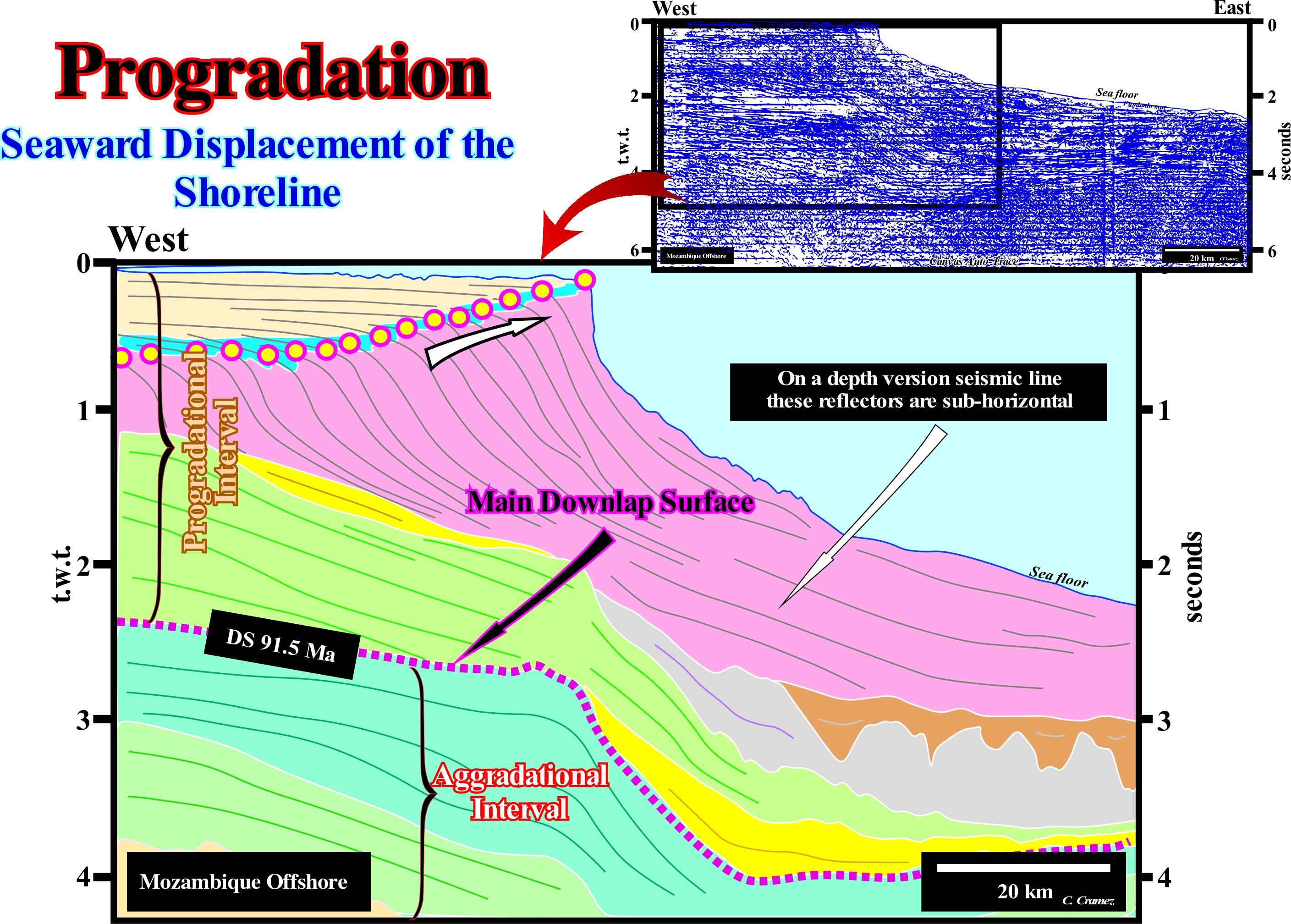
On this tentative geological interpretation of a Canvas auto-trace of a Mozambique offshore seismic line, it is necessary to remember that the very rapid lateral variation of the water-depth creates an important seismic pitfall. The distal segments of the reflectors, located eastward of the present continental edge, on a depth-version seismic line, are, probably, shallower than the western chronostratigraphic segments. The seismic waves spend less time crossing the water-depth than the sedimentary column. On a depth-version of this line, to which we have access, the reflectors located downstream of the continental edge are much less inclined seaward. It can even be said the deep horizons of this divergent margin dip continentward, where the subsidence was more important and where the depocenters are located (places of maximum deposition, where the stratigraphic unit considered has the greatest thickness). One of the major mistakes that we have seen until recently in many oil companies is that they consider that the substratum of divergent continental margins, whether they are of the Atlantic-type or not, dips seaward, which is in most cases is an error with consequences, sometimes dramatic, in petroleum systems exploration. Obviously, this error is the result of an uncritical, inductive scientific approach in which geoscientists often forget that seismic lines are not just profiles in time and not depth profiles. They are just simple approximations of geological reality. As P. Bak said there is a big difference between "Beeing and Observing". Practically, in all offshore, the substrate of the margin dips towards the continent, but as the water-depth increases seaward, in a profile in time, its inclination can be inverted. Two sedimentary intervals are easily recognized on this tentative interpretation: (i) An aggradational interval in which the reflector configuration is, more or less, parallel and (ii) A progradational interval in which the geometry of the reflectors is sigmoid. The lower interval corresponds to the transgressive phase of the post-Pangea continental encroachment cycle, while the upper progradational interval corresponds to the regressive phase of the same stratigraphic cycle. These two intervals are separated by a downlap surface (dashed line colored in violet). In the progradational interval two subintervals can be considered. In the lower subinterval, the geometry of the sequence-paracycle, limited between two consecutive chronostratigraphic, is poorly defined: the seismic line is not sufficiently long and the tentative interpretation is not calibrated in geological time. On the contrary, the sigmoid geometry of the paracycles or sequence-cycle (all depends on the age of the consecutive chronostratigraphic lines) of the upper subinterval, is perfectly defined. The sigmoid geometry is characteristic of the great majority of cycles or sequence-paracycles of the upper subinterval, defined by the chronostratigraphic lines, that the geoscientist calls progradations, mainly, when they have the form of a S backwards and, more or less, stretched. In this subinterval, taking into account the vertical scale (double time, i.e., t.w.t.), the upper slope break of each reflector corresponds to the continental edge and the break below corresponds to the boundary between the continental slope and the abyssal plain. Thus, it may be said in this subinterval, over time, the continental edge shifted, progressively, seaward and upwards, as underlined by the white circles. In the lower subinterval, the seaward displacement (progradation) seems more important than the vertical displacement (aggradation = upbuilding)), whereas in the upper subinterval, although the seaward displacement is preponderant, the vertical displacement (aggradation) is much more significant than in the lower subinterval. At the bottom of each of the subintervals of the regressive phase of the post-Pangea continental encroachment cycle, the geological conditions appear to be lowstand, since the sediments appear to have deposited lower than the basin edge. However, a more attentive observation shows that the great slope break of the seismic horizons probably corresponds to the seismic pitfall induced by the abrupt change in water-depth. This means that in a depth-version of this seismic line, the geometry and the geometric relationships between the reflectors would be very different, which forces, in a first stage of the tentative interpretation, the geoscientists to consider the geometrical relations between the reflectors eastward of the present-time platform (shelf) as, mainly, apparent.
Progradational Complex (late highstand prograding complex)................Complexe progradant (Haut niveau tardif)
Complexe progradant (haut niveat tardif) / Complejo progradante (nivel alto tardío) / Progradierenden Komplex (hohe spät), Späte Highstand progradierenden komplexen / 晚期高位prograding复杂, Prograding复杂(高晚) / Проградирующий комплекс системы высокого уровня моря / Complesso progradanti (alto livello del mare in ritardo) /
Upper part of the highstand prograding wedge (HPW) deposited when the relative sea level rise is very small and lower than the rate of terrigenous influx, which forces the sequence-paracycles to prograde,strongly, basinward. It corresponds, sometimes, to the second stage of development of the highstand prograding wedge (HPW) during which the basin has no shelf.
See: « Highstand (sea level) »
&
« Systems Tract »
&
« Lowstand Prograding Wedge »
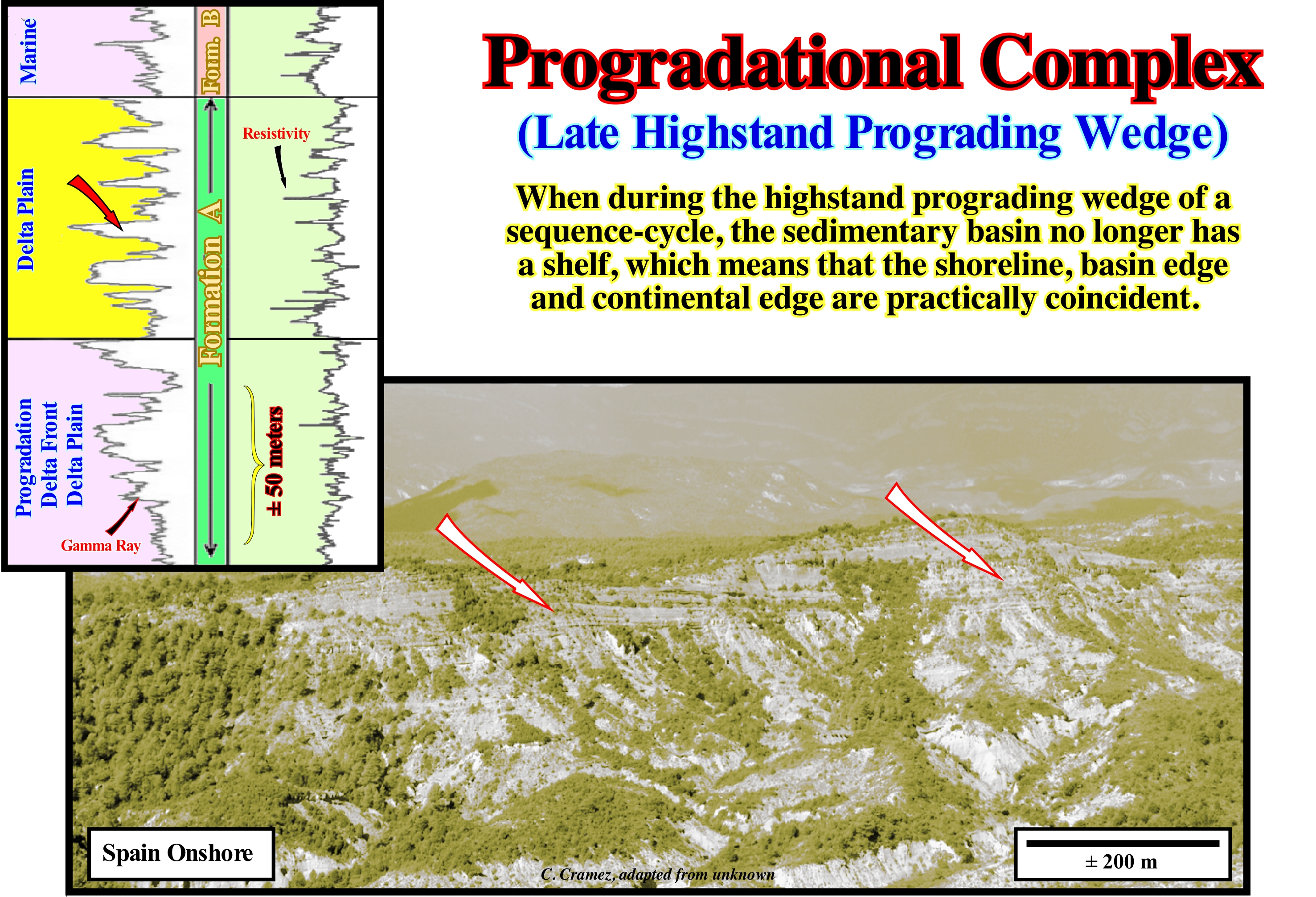
Aggradation (vertical deposition or upbuilding) and progradation or outbuilding (lateral deposition with a seaward displacement to the depositional coastal break of the depositional surface) of the sequence-paracycles (induced by relative sea level rises without descent between them, i.e., by paracycles) which form highstand prograding wedge (HPW) suggest the sedimentary particles have been deposited during a relative sea level rise*, in deceleration, with a relatively low terrigeneous influx. Taking into account the curve of relative sea level changes and where deposition has taken place, it is possible to recognize an early phase (1st phase) of development and a 2nd phase. The initial phase is deposited in the lower and middle part of the curve (above the inflection point), when the relative sea level rises, already, in deceleration, but still in a fast way (basin with shelf). During this 1st phase of deposition of the highstand prograding wedge (HPW), the basin has a continental platform (shelf): the shelf break of the depositional surface, which in the seismic lines, roughly, coincides with the shoreline, is the upstream basin edge (continental edge). Since the basin has no continental platform (no shelf), i.e., since the shoreline coincides, more or less, with the continental edge, which in these conditions becomes the new basin edge (taking into account the seismic resolution), begins with the development of the 2nd phase of the highstand prograding wedge, which certain geoscientists call the prograding complex or late highstand prograding wedge. The deposition of this 2nd phase of the highstand prograding wedge occurs at the top of the relative sea level change curve, when the relative sea level rise is decelerating (basin without continental platform or no shelf ). Since the relative sea level changes curve is, in mathematical terms, a function f (x), it can be said the lowstand prograding wedge (LPW) is deposited in association with the sector of the curve characterized by a positive 1st derivative and a negative 2nd derivative, i.e., when the function has a crescent convex geometry. During the 1st phase of the development of the highstand prograding wedge (HPW), the 1st derivative is, largely, greater than zero. Since it begins to approach zero, the 2nd phase of development starts, that is, the late highstand prograding wedge starts. In general, during the early phase of development, the terrigeneous influx rate is, more or less, equal to the relative sea level rise rate, which creates a significant aggradation of the sequence-paracycles. During the late phase, the rate of the terrigeneous influx is higher than the rate relative sea level rise, which forces the centre of deposition of the sequence-paracycles to move seaward, which gives it very accentuated progradational geometry. In certain cases, only the geometry of the base of sequence-paracycle allows them to be associated with a relative sea level rise and not a small relative sea level fall characteristic of forced regressions (type of regression that occurs during the base level fall, in which the shoreline is forced to prograde by lowering the base level, independently, from the terrigeneous influx). In the electrical logs (gamma ray and resistivity) illustrated in the lower right corner of this figure, it is, relatively, easy to recognize a progradational complex or late highstand prograding wedge, at the top of geological formation A, which underlines the delta plain (the filling the beds of the rivers is evident in gamma ray log), which fossilizes the delta front progradational deposits (take into account the Walther's law). The geometry of the gamma ray log of the delta front deposits is, as can be seen, typically coarsening and thickening upward (the thickness of the strata and the granulometry of the grains increases upwards). We recall that gamma ray log reflect the clay content in the sediments, since the minerals containing radioactive isotopes (most frequently potassium) tend to concentrate on shaly sediments.
(*) In sequential stratigraphy, sea level may be relative or absolute (eustatic). The former is local and referenced to any point on the Earth's surface, either the base of the sediments (top of the continental crust) or the floor. The second, i.e., the absolute or eustatic sea level is supposed to be global and referenced to a fixed point that is usually the Earth's centre. The relative sea level is the result of the combination of absolute or eustatic sea level and tectonics (subsidence or uplift of the sea floor).
(**) Walther's Law states that a vertical succession of facies (lithology, fauna, environment) also reflects a lateral succession. A lateral migration of facies implies a vertical succession.
Progradational Configuration (Reflectors).................................................Configuration progradante
Configuração progradante / Configuración progradante / Progradierender Konfiguration / progradational 配置 / Проградационная конфигурация / Configurazione progradazionale
Set of seismic reflectors interpreted as strata with a progradational geometry, sometimes associated with regressive intervals (TI) of a sequence-cycle.
See: « Stratal Patterns »
&
« Reflection Configuration »
&
« Continental Encroachment Subcycle »

A progradational configuration is a very general expression since an oblique, sigmoid, tangential oblique, etc. configurations are all progradational, i.e., the depositional coastal break of the depositional surface (which on the seismic lines almost corresponds to the shoreline) moves seaward. This is what, usually, happens within a sequence-cycle, during lowstand prograding wedge (LPW) or during the 2nd phase of highstand prograding wedge (HPW)*. The seaward displacement of the coastal deposits can be done upward, i.e., with a positive aggradation, or downward with a negative aggradation. In the first case there is continuity of sedimentation (rise of relative sea level **), while in the second no. The second case is associated with a significant relative sea level fall, which put the relative sea level lower than the basin edge, which exhumed the continental shelf (if the basin had one) and the upper part of continental slope, creating an erosional surface, that is, an unconformity. When within a sequence-cycle, the basin has no shelf, the depositional coastal break of the depositional surface (more or less the shoreline) of the progradational interval (globally regressive), corresponds, roughly, with the the continental edge, which coincides, practically, with the shoreline. On this tentative geologically interpretation of a West Australia seismic offshore seismic line, at least six progradational intervals, separated by unconformities (significant falls of the relative sea level, i.e., of a local sea level referenced to the sea floor or to the base of the sediments) were recognized above a substrate, which has a parallel internal configuration. These progradational intervals, probably, correspond to continental encroachment sub-cycles deposited during 2nd order eustatic cycles (time-duration 3-5/50 M). Within each of these intervals there is one or several relative sea level falls, which have obliged the coastal onlaps to move seaward. Therefore, one or more higher-order stratigraphic cycles (sequence-cycles) may exist within a continental encroachment subcycle. In general, the visible seismic reflectors within these intervals correspond to sigmoid progradations, since the three segments that form them are well represented. The upper horizontal segment represents shallow water deposits (platform deposits). The seaward dipping segment corresponds to slope deposits (continental slope, taking into account the vertical scale of the seismic line). The lower horizontal segment corresponds to deep-water deposits that may be of turbidite or pelagic origin. Take into account, in particular in the three upper seismic intervals, the seismic pitfall introduced by the abrupt change of the water-depth (passage from the platform to the continental slope). At these intervals, the sigmoid geometry of the reflectors is, largely, apparent, since it is induced to a large extent by lateral velocity interval change (water/sediments). The main internal progradational configurations of the seismic intervals are schematised: (i) Sigmoid, the progradations have a geometry of a S upside down, which means that the inclination in the upper and lower parts is relatively weak, whereas in the median part median is much stronger ; (ii) Oblique Tangent, in this pattern, the seismic reflectors or the associated strata have a decreasing dip toward the base ; (iii) Oblique Parallel, a set of seismic reflectors with an oblique/parallel pattern, in which the strata terminate downstream with a relatively high dip ; (iv) Sigmoid/Oblique, a particular case of the sigmoid configuration, in which the inclination of the median segment of the progradations is very strong and the presence of toplaps by truncation is frequent ; (v) Shingled, the arrangement of the reflectors where the progradations are obliques and almost lying down seeming to take turns one after the other and (vi) Hummocky or wavy, set of seismic reflectors with opposite dips, interpreted as strata associated with submarine slope fans (turbiditic natural marginal dikes or levels and fillings of the depressions between them or filling of channels, in case of evident erosion, where the currents have passed).
(*) During the 1st phase of the deposition of the highstand prograding wedge (HPW) ,the basin has a continental shelf (the shoreline is positioned upstream of the basin edge, which emphasizes the continental edge), while during the 2nd stage the basin has no shelf, since it was, totally, fossilized by the progradations.
(**) This automatically excluded the deposits, within the considered sequence, of the descending sedimentary systems tracts , that is, of forced regressions.
Progradational Filling (Seismic lines).............................................................................................Remplissage progradant
Remplissage progradant / Relleno progradante / Füllung progradierenden / 前积充填 / Наступление береговой линии / Riempimento progradante /
When the seismic reflectors, interpreted as strata, have a progradational geometry. In most cases, such a filling is associated with regressive sedimentary intervals (lowstand prograding wedge and high stand prograding wedge).
See:« Reflection Configuration »
&
« Progradation»
&
« Relative Sea Level Change »
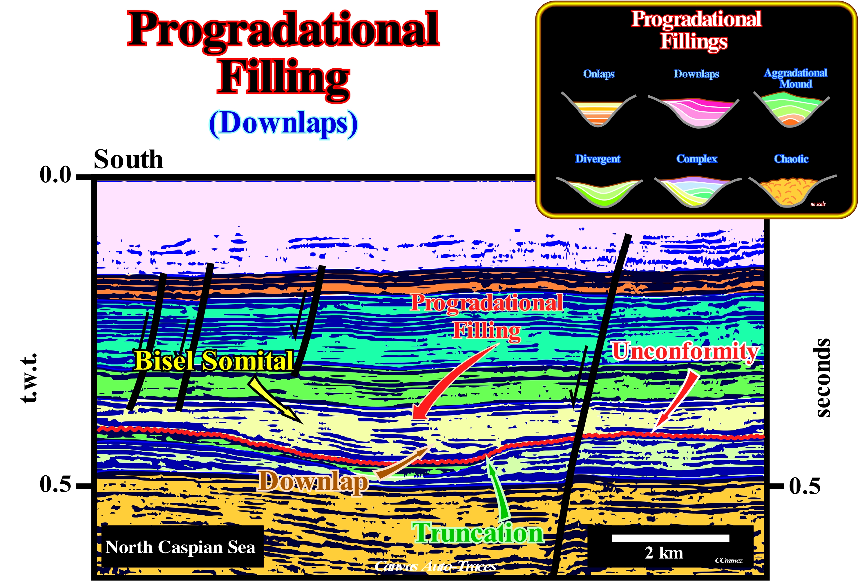
On this tentative geological interpretation of a Canvas auto-trace of a detail of a North Caspian Sea seismic line, an incised valley and an unconformity are, easily. recognized. The unconformity, which corresponding to an erosional surface, was created by the joint action between the tectonics (subsidence or uplift) and the absolute (eustatic) sea level (supposed global sea level, referenced to the Earth's centre. This combined action induces a significant relative sea level fall (local sea level, referenced at any point on the land surface, whether it is the base of the sediments or the sea floor), which put the sea level lower than the basin edge of the sequence-cycle. The sequence-cycle was complete, i.e., formed by all sub-groups of sedimentary systems tracts, which from below upwards are: (i) Submarine basin floor fans (SBFF) ; (ii) Submarine Slope Fans (SSF) ; (iii) Lowstand Prograding Wedge (LPW) ; (iv) Transgressive Interval (TI) and (v) Highstand Prograding Wedge (HPW). The basin edge was, certainly, the continental edge of the highstand prograding wedge (HPW). During the lowstand systems tracts group (SBFF, SSF and LPW) of the new sequence-cycle, the basin edge remained the same (last basin edge of of the preceding sequence-cycle) until the transgressive surface occurred. From that moment on, the basin has a continental shelf and, thus, the basin edge of the lowstand prograding wedge (LPW) becomes the new basin edge. Such a relative sea level fall not only exhumed the platform of the basin (if the basin had a shelf), but also displaced seaward and downward the river mouths. The provisional equilibrium profiles of the watercourses were broken, which forced the currents to incised deeper into their beds so that new provisional equilibrium profiles are reached. It is this excavation that creates the incised valleys, like what is illustrated on this tentative interpretation, south of the main normal fault. When the relative sea level began to rise in acceleration (increasingly important marine ingressions), probably, during the upper part of the lowstand prograding wedge (stacking of sedimentary systems tracts, i.e., of progradational sequences paracycles deposited under lowstand geological conditions) or during the lower part of the transgressive interval (retrogradational stacking of sequence-paracycles deposited under highstand geological conditions) the incised valley was filled. The completion is typically progradational. The downlaps suggest a terrigeneous influx coming from the south, which in turn indicates, more or less, the location of the continent. As these downlaps are, likely, to be apparent, the combination with reflections terminations found on other seismic lines that also cut the incised valley will give the true direction of the terrigeneous influx. A progradational geometry of the filling of an incised valley is not contradictory to its association with the lowstand prograding wedge (LPW) nor with the transgressive interval (TI) of the associated sequence-cycle. Indeed, although the transgressive interval (TI) of a sequence-cycle, which corresponds to a set of increasingly important marine ingressions and increasingly smaller sedimentary regressions, has, overall, a retrogradational geometry, within each paracycle-sequence bounded by two consecutive relative sea level rises without significant falls, the geometry of the sedimentary systems tracts (lateral association of synchronous and genetically linked deposition systems) is progradational, which means that the shoreline moves seaward as the sedimentation occurs (indicates the direction of the terrigeneous influx). Seismically, due to the resolution of the seismic lines, often, a sequence-paracycle may correspond to several sedimentary systems tracts, which, in general, is not the case, in the field, that is, at the natural 1: 1 scale.
Promontory................................................................................................................................................................................................................Promontoire
Promontório / Promontorio / Vorgebirge / 海角 / Структурный выступ / Promontorio /
Headland, usually, high, that extends into a water-body.
See: « Pinnacle »
&
« Littoral »
&
« Cliff »
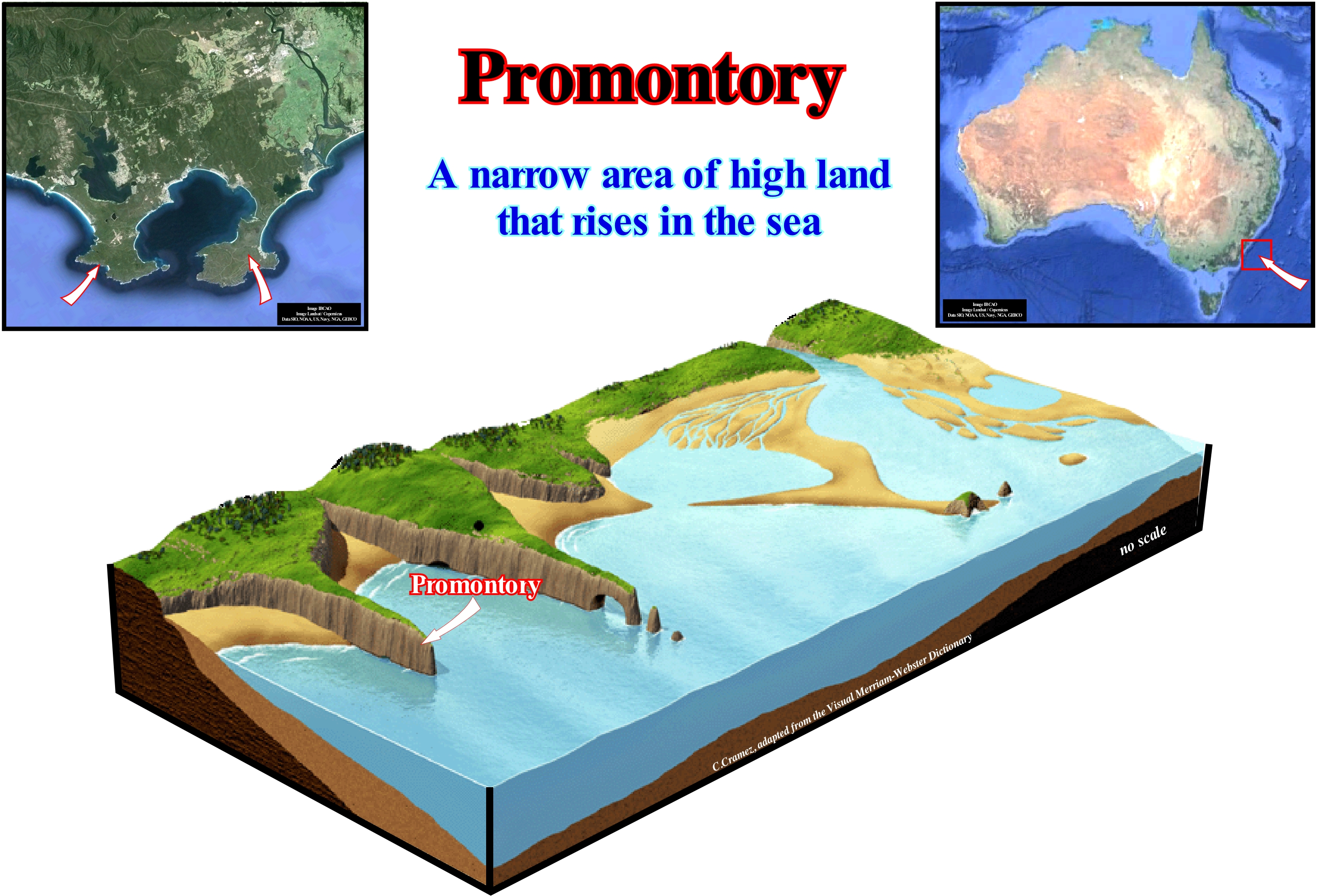
As illustrated in this figure, a promontory is a kind of peninsula or a generally high, earthy tip that extends into a water-body and therefore has three sides. In general, the side of the promontory parallel to the shoreline is much smaller than the other sides which are, more or less, perpendicular and may have significant lengths. In the Dictionary Priberam of the Portuguese Language, a promontory is defined as "cape formed by a high mountain", while cape is defined as "land that protrudes from the shoreline or forms the vertex of two coasts, synonym of tip". That means that according to this dictionary a cape and promontory are not synonyms. However, for many geoscientists, cape and promontory are considered as synonyms. In geography, a cape is defined as a geographic accident formed by a mass of land that extends in an ocean or sea that is adjacent to it. In general, a cape, which is a narrow peninsula, has more importance than a promontory and exerts, often, influence on coastal currents and other oceanographic characteristics of its environment. Some capes are, especially, famous denoting important points of the continents or islands in which they are located. The navigation between capes without losing visual contact with the coast is called "cabotage". In Europe, the Cape of Finisterra (Spain), the North Cape (Norway), the Cabo da Rocha (Portugal), the Cape of São Vicente (Portugal) are undoubtedly the most famous capes. In navigation (science, art, practice or technology, to plan and execute a voyage from a point of departure to its destination point) large cape or large promontory is the name given to the three main southern capes of the sea route through the Southern Ocean: (i) Cape of Good Hope in South Africa ; (ii) Australia's Cape Leeuwin and (iii) South America's Cape Horn.
Proterozoic...............................................................................................................................................................................................................Proterozoïque
Proterozóico / Proterozóico / Proterozoikum / 元古宙 / Протерозой / Proterozoico /
Geological eon between the Archean (2.5 Ga) and Phanerozoic (590 Ma), within which certain geoscientists consider various geological periods, such as: (i) Vendian ; (ii) Sturcianium ; (iii) Yurmatian ; (iv) Burzyan ; (v) Huronian and (vi) Randian. The denominations of these periods do not have international status.
See: « Eon »
&
« Geological Time Scale »
&
« Geological Time »
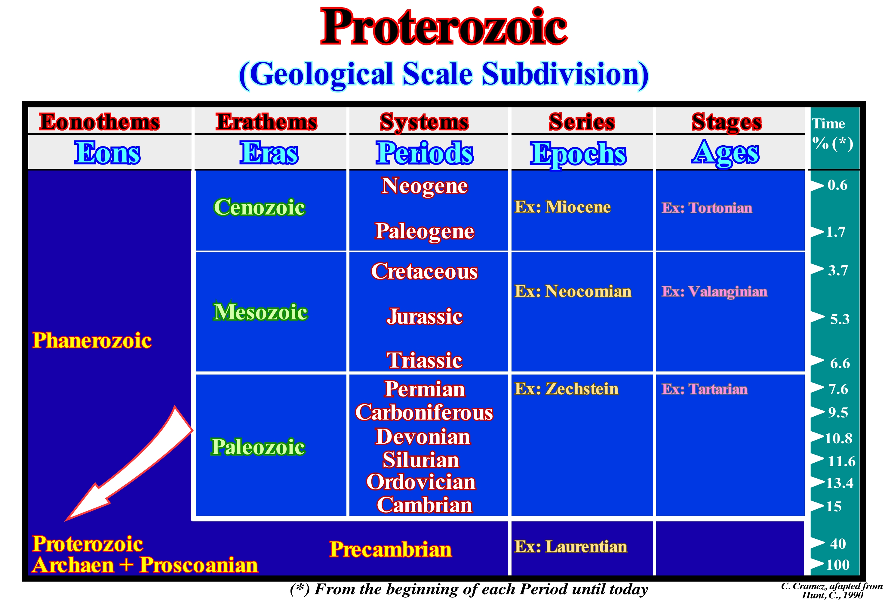
The Proterozoic lasted about 1,910 My, which compared to the Earth's age (4.5 Ga, that is, formed 4.5 billion years ago) represents about 40% of the geological history, as indicated in the column Time (%) of this figure. It appears that the Earth formed at about 4.5 Ga, but that almost 4.0 Gy (4 billion years) passed until the first animals appeared. It is this interval of time that the geoscientists call Precambrian. Some geoscientists avoid this term and prefer to consider, before the Phanerozoic, three Eons (Harland et al., 1982): (i) Proterozoic, between 590 and 2500 Ma ; (ii) Archaen, between 2500 Ma and 4000 Ma, and (iii) Priscoanian, between 4000 Ma and 4500 Ma (do not forget that Ma represents an age and My a time interval). In any case, speaking of the Precambrian as a mere time-interval is meaningless, since it represents about 86% of Earth's history. Contrary to the deep deposits of the Archaic, many of the sediments of the Proterozoic have been deposited in epicontinental seas and are much less metamorphosed. The study of sediments of the Proterozoic showed that during this era there was a rapid accretion of the continents (which seems not to have happened in the following aeons) and formation of several cycles of supercontinents, suggesting the presence of intense plate tectonics. During this era the first glaciations appeared, whose climax occurred during the Varangian period (± 670 Ma) with the formation of the "Snowball Earth*". One of the most important events during this era was the gradual increase of oxygen in the atmosphere. Although the oxygen was released by photosynthesis already during the Archean, it can only begin to accumulate, significantly, when the chemical absorbents, such as sulfur and iron, have saturated, which seems to have happened about 2.3 Ga , when the oxygen content in the atmosphere was about 1% or 2% of the actual value.
(*) Hypothesis proposing that during one or more of Earth's ice-houses climates, Earth's surfacebecame entirely or nearly entirely frozen at least once, sometime earlier than 650 Ma.
Protopangea............................................................................................................................................................................................................Proto-Pangée
Protopangeia / Proto-Pangea / Proto-Pangea / 原始的盘古 / Прото-Пангея / Proto-Pangea /
Supercontinent that formed at the end the Proterozoic. Synonym with Rodhinia*. The formation and breakup of supercontinents seems to have been cyclical throughout the Earth's history. There must have been several supercontinents before Pangea. Among them the Columbia (or Nuna) seems to have formed between 2.0-1.8 Ga. The Rodhinia seems to have lasted from about 1.1 Ga to 0.75 Ga, but its exact configuration and its geodynamic history are not as well known as those of the more recent supercontinents like Pannotia and Pangea.
See: « Continental Collision »
&
« Pangea »
&
« Supercontinent »
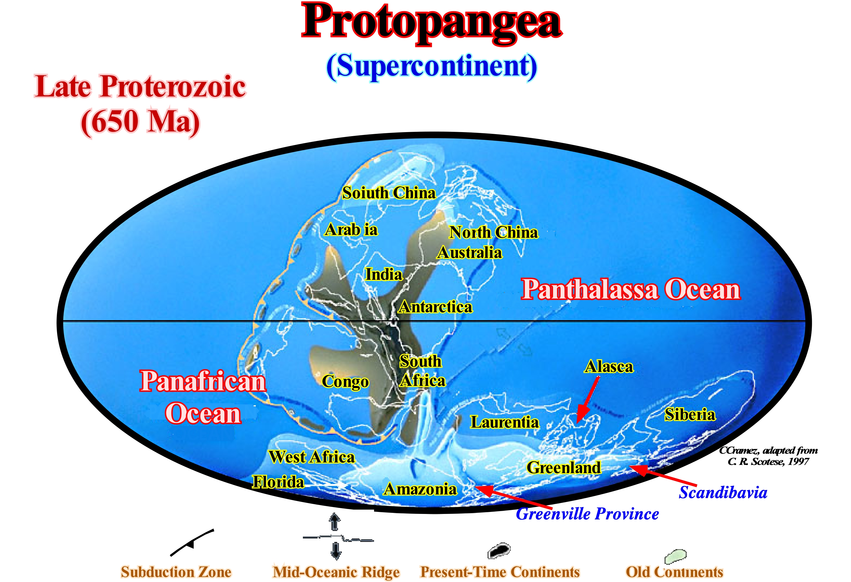
The geological record of consolidation and uplift of the crustal protolith (rocks from which new rocks were formed). identifies three large groupings of cratonic nuclei of Archean age (Rogers, 1996): A) Cratonic nucleus of Ur, which existed, more or less, about 3.0 Ga, and which included the cratons of Southern Africa, Western Australia ; B) Arctic cratonic nucleus, which existed, more or less, 2.5 Ga and which included the cratons of Greenland, Fenoscandia, Laurentia and Siberia and C) Cratonic nucleus of Atlantic, which existed for about 2,0 Ga and encompassing the craters of West and South Africa. Paleomagnetic and geological data suggest that Archean continental crust coalesced, probably, during the Middle Archean, into a crescent supercontinent that the geoscientists called Protopangea. The terms supercontinent and small supercontinent are the names given in geology to terrestrial masses which consist of one or more cratons or continental nuclei. The term supercontinent is generally used, for example, for the supercontinent Pangea and the term small supercontinent is used for the small supercontinents Gondwana and Laurasia that form, respectively, the South and North of the supercontinent Pangea, and which are constituted by several continents, such as Laurentia, Baltica, Siberia, etc. The list of supercontinents is quite extensive: (i) Supercontinent Vaalbara, which existed about 3,8 Ga ; (ii) Supercontinent Ur, which existed for about 3.0 Ga ; (iii) Kenorland Supercontinent, which existed for about 2.7 Ga ; (iv) Supercontinent Nena, which existed for about 1.8 Ga ; (v) Columbia supercontinent, which existed for about 1.8 Ga ; (vi) Atlantic Supercontinent, which existed for about 1.8 Ga ; (vii) Supercontinent Protopangea or Rodhinia, which existed for about 1.1 Ga ; (viii) Supercontinent Pannotia, which existed about 0.6 Ga ; (ix) Euramerican Supercontinent, which existed for about 0.4 Ga ; (x) Supercontinent Pangea, which existed for about 0.3 Ga. The small supercontinent Gondwana, which existed about 0.2 Ga, was formed by the following continents: 1) Antarctica ; 2) Africa ; 3) Madagascar ; 4) Seychelles ; 5) India ; 6) Australia ; 7) New Guinea ; 8) New Zealand and 9) New Caledonia. The small supercontinent Laurasia, which existed for about 0.2 Ga, consisted mainly of the following continents: a) Laurentia; b) Baltica ; c) Siberia ; d) Kazakhstan ; (e) Northern China ; f) East China. The supercontinent Proto-Pangea, which is considered by some geoscientists as the seventh continent, also called Rodhinia (which in Russian means motherland), seems to have existed between approximately 1,100 and 750 Ma. Unlike the supercontinent Pangea, which existed to the about 300 Ma, the exact configuration and geodynamic history of the Protopangea is still poorly known. Certain paleomagnetic data suggest paleolatitudes for certain portions of the continental mass forming the supercontinent, which geoscientists try to join together as illustrated in this figure. Most of the Protopangea was, probably, located to the south of the equator, with the central part formed by the North American craton (the last paleocontinent of Laurentia) and the SE by Eastern Europe (the last paleocontinent of the Baltica), Amazonia and Africa West. To the south were the cratons of Rio de la Plata and San Francisco. The positions of Siberia, North and South of China and the North American craton vary according to geoscientists. A global glaciation of the Proterozoic began at about 800 Ma in the Proto-Pangea and ended with the break-up of the supercontinent about 590 Ma. The conjecture that the Protopangea existed from 1,100 Ma to 700/750 Ma, without breakup of the lithosphere is contested by several geoscientists who say a supercontinent can not survive without breaking a period of 400 My due to the development of thermal anomalies in the asthenosphere that cause thinning of the lithosphere and probably its breakup. They advance, a period of, more or less. 100 My between the agglutination of a supercontinent and its breakup. Once the supercontinent breaks, the individualized continents disperse to, after reaching the maximum dispersion, gradually, begin to coalesce to form a new supercontinent. This supercontinent cycle, breaking, continents, agglutination, supercontinent, called the Wilson cycle, rarely lasts more than 400 My.
(*) Rodhinia supercontinent (from Russian "rodit"= growth was formed around 1.1 Ga as a result of the Grenville orogeny. The Rodhinia central part, on the equator, was occupied by Laurentia (North America and Greenland), surrounding Amazonia flanked by West Africa, Baltica, Siberia and the Indian craton Indian associated with four Australian cratons and the Chinese craton. After the Rodhinia break-up, between 600 and 560 Ma was reconstituted an ephemere Pannotia supercontinent Pannotia which, later, burst to form Laurentia and Siberia, then Baltica around 540, at the very end of the Proterozoic opening the Iapetus ocean.
Prototethys.....................................................................................................................................................................................................................Proto-Téthys
Prototétis / Proto-Tetis / Proto-Tethys / 原特提斯洋 / Прото-Тетис / Proto-Thetys /
Ancient ocean, predecessor of the ocean Paleotethys. It existed from the end of the Proterozoic to the Carboniferous (550/330 Ma). It was formed due to the fracture of the supercontinent Pannotia and the individualization of the continent Protolaurasia (Laurentia, Baltica and Siberia). The Prototethys ocean formed between these two supercontinents.
See: « Tethys Sea »
Protokaryota............................................................................................................................................................................................................Protocaryote
Protocariota / Protocariota / Protokaryote (ohne Zellkern) / Protokariote(无细胞核)/ Протокариот / Protokaryote (senza un nucleo cellulare) /
A term little used to designate a prokaryote, that is, an organism in which the genomic DNA is not enveloped by a nuclear membrane within the cells. As an example of protokaryotas, which form their own kingdom, called Monera or Prokaryota, we can mention bacteria and blue algae.
See: « Cyanobacteria »
&
« Eukaryota »
&
« Brown Algae (Pheophyceae) »
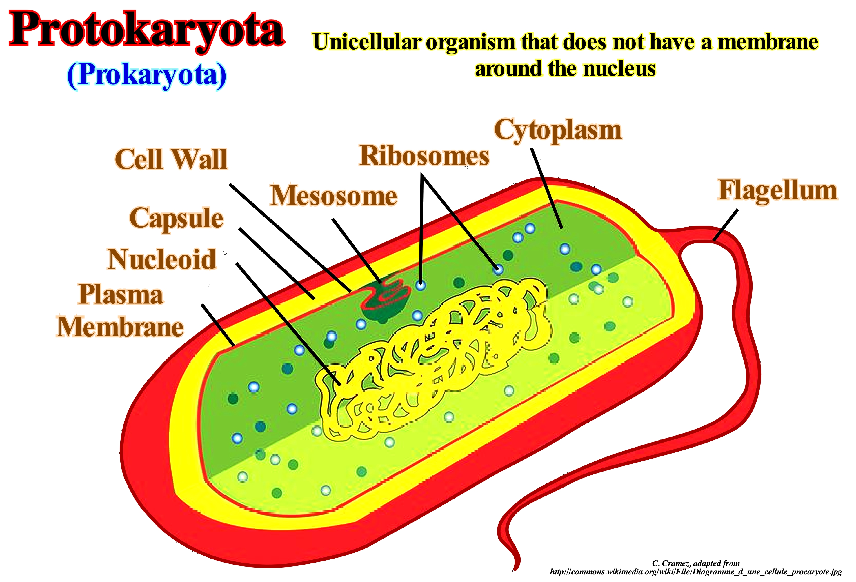
Protokaryotes, Prokaryontes, Prokaryotes, which are synonyms, are unicellular organisms that do not have their genetic material delimited by a membrane. These beings do not have any type of internal compartmentalization by membranes, being absent several other organelles, such as the mitochondria, the Golgi Complex and the mitotic spindle. This definition encompasses all organisms in the Bacteria and Archaea domains. Such cells have several other differences when compared to eukaryotic cells. They do not possess most of the organelles (the ribosome is present), their DNA is cyclic, the fluidity of their membranes are only controlled by phospholipids (and not by phospholipids and steroids as in eukaryotic cells), they do not join together to form multicellular organisms, since it does not have the capacity to form fabrics, etc. This name has Greek origin where karyon, means nut or nucleus, combined with the prefix pro-, which means anterior. Cells with a nucleus are called eukaryotes, where the prefix eu- means good or true. In some prokaryotic cells observed under the electron microscope, very little visible nuclear traces were observed. The prokaryotes have very diversified metabolisms, which is reflected in their ability to colonize different environments, such as digestive tract of animals, volcanic environments, brackish environments, etc. Although they do not have cellular organelles, they can conduct their metabolic processes in the cell membrane. Most have a cell wall, something that does not happen with certain types of eukaryotic cells (like those of animals). Protokaryotes are always single-celled organisms, reproducing asexually by binary fission. Other forms of DNA recombination between prokaryotes include transformation and transduction* (reproduction in which bacterial DNA is transferred from one bacterium to another by a virus, called bacteriophages).
(*) Transduction is the process by which foreign DNA is introduced into a cell by a virus or viral vector .An example is the viral transfer of DNA from one bacterium to another and hence an example of horizontal gene transfer. (https://en.wikipedia.org/wiki/ Transduction_(genetics)).
Protocontinent............................................................................................................................................................................................Protocontinent
Protocontinente / Proto-continente / Protokontinent / 原大陆 / Протоконтинент / Protocontinente /
One of the first continents of the Earth that formed during the Hadean and Archean eons in association with the movement of the tectonic plates. The protocontinents agglutinated into larger continents. As the protocontinents were geologically young, easily deformable, and subjected to intense geological processes, they are considered by many geoscientists to be unstable.
see: « Craton »
Protodolomite.................................................................................................................................................................................................Protodolomite
Protodolomite / Protodolomite / Protodolomite (Calcium-Magnesium mit Metallionen) / Protodolomite (与金属离子钙,镁) / Протодоломит / Protodolomite (calcio-magnesio con ioni metallici) /
This term is often applied to Holocene dolomites (a variety of double calcium and magnesium carbonate) which have formed during the last 10 ka and which are characterized by the fact that some calcium layers may contain magnesium and some magnesium layers may contain calcium .
See: « Diagenesis »
&
« Dolomitization »
&
« Porosity »
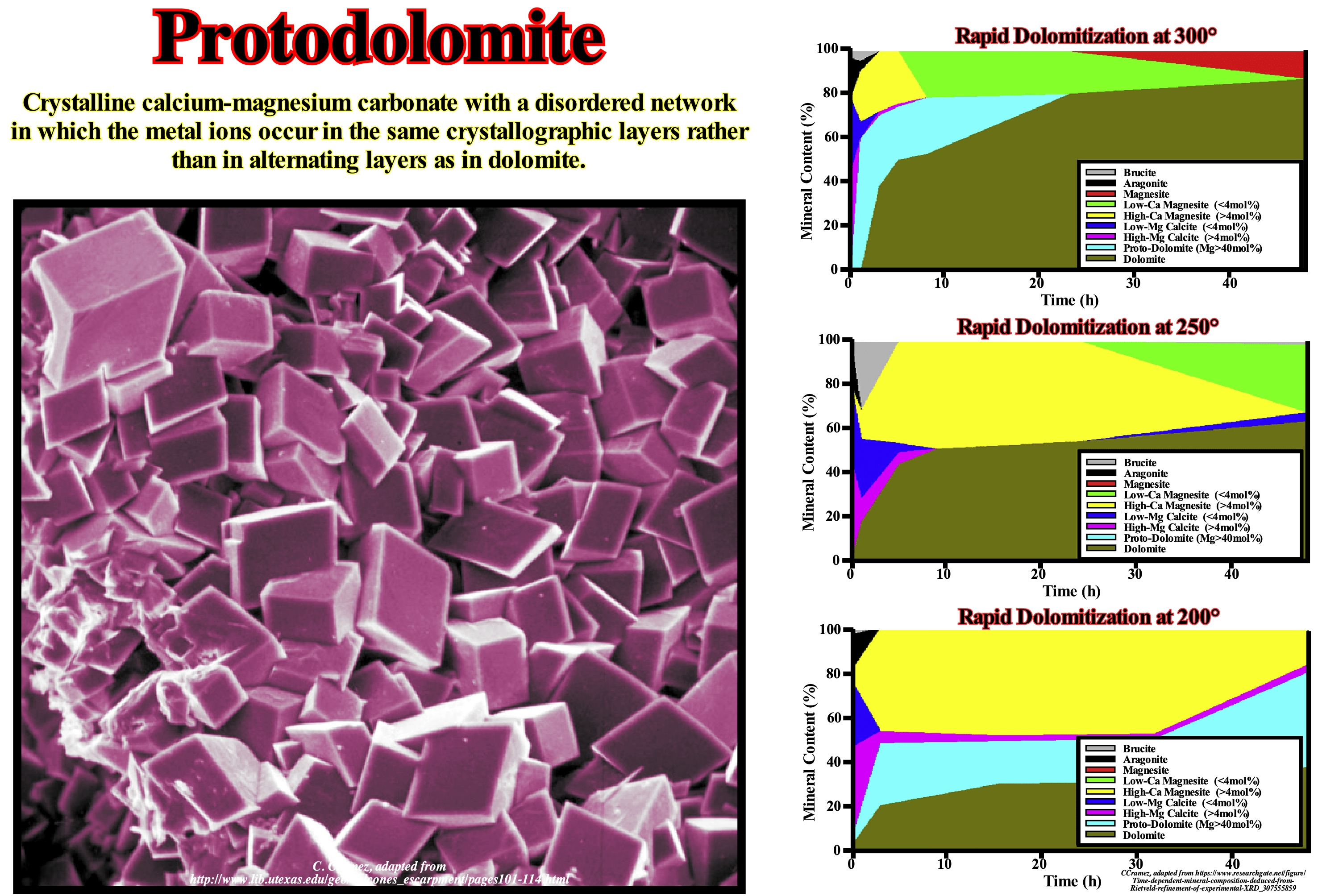
This photograph (240 microns) illustrates protodolomite crystals that have filled the cavity of a shell formed by leaching (a process by which water dissolves and transports the soluble components of a rock). Certain geoscientists describe protodolomite as a crystalline calcium and magnesium carbonate with a disordered structure in which the ions (atom, group of atoms or molecule that has lost its electrical neutrality by having lost one or more electrons, acquiring positive charge) same crystallographic layers instead of alternating layers as is the case in dolomite. In an approximate way, the structure of dolomite can be described as that of calcite, but with magnesium ions replacing calcium ions in each layer of cations (atom, group of atoms or molecule that has lost its electrical neutrality by having captured a or more electrons, acquiring positive charge). The structure of dolomite can be seen as having a calcium layer, a CO3 layer, a magnesium layer, another CO3 layer and so on. Although, in marine environments, dolomite is more stable than calcite, dolomite does not form directly in these environments, either inorganic or biologically, but by diagenetic processes. The mechanism of formation of sedimentary dolomites is poorly understood, which is one of the interesting problems of carbonate geochemistry. Many geoscientists have indicated the frequent occurrence of protodolomite in the Quaternary Dolomites. Protodolomite is relatively abundant in the inner part of the intra-tidal zone, since the evaporation and precipitation of aragonite (from the lagoons) and gypsum (under the carpet) increases the Mg/Ca ratio of pore water. Formation of protodolomite is also observed in the isolated ephemeral lakes and lagoons of the sea, where evaporation is very important, particularly during the summer, which produces brine-rich brines from which the aragonite and protodolomite precipitate.
Protogen (Sediment).............................................................................................................................................................................Protogène (Sédiments)
Protógeno / Protógeno (sedimento) / Protogene (abgeleitet vom alten Bergkristall klar) / Protogene(来自古老的岩石晶莹剔透) / Липоевая кислота / Protogene (derivato da cristallo di rocca antica chiaro) /
Sedimentary particle derived from primitive crystalline rocks is called protogen (by certain geoscientists), although this term is also used for a granite in which the talc supplants the mica.
See: « Sediment »
&
« Deposition (clastics) »
&
« Principle of Composition »
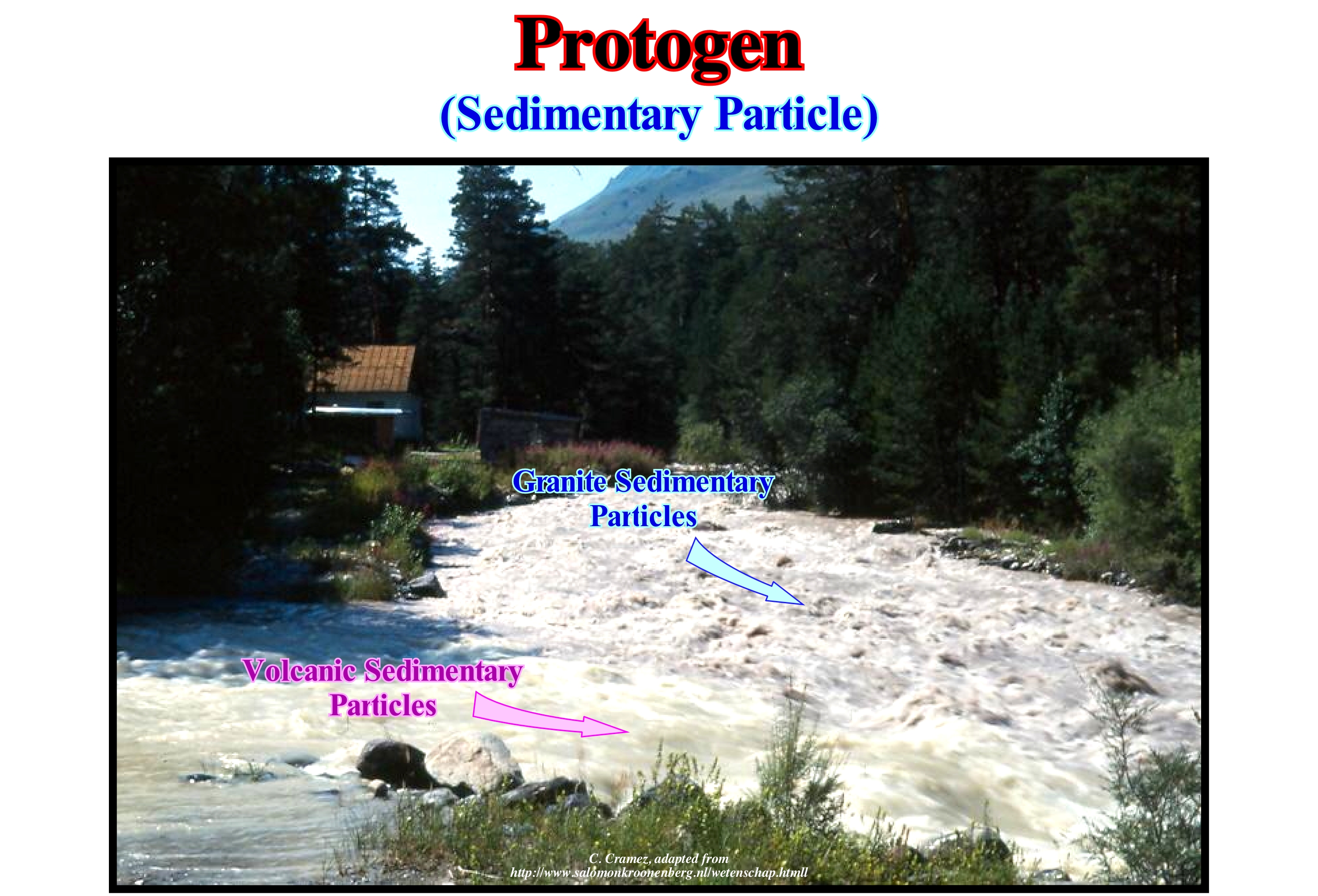
Although in certain languages the term protogene means very small or small, in Geology, it is used to designate two very different things. In Sedimentology, it is used to designate a particular type of sedimentary particle. In petrography* to designate a variety of granite. For example, in this photograph, the two streams come from different places with different drainage basins. The drainage basin of the central river, which is more turbulent, is located within a granite massif, while the drainage basin of the other river, which comes from the left, is located in volcanic terrain. In this way, according to the definition of protogene (sedimentology), it is possible to be said the central river transports, mainly, protogenes, as for instance, quartz, feldspars, zircons, micas, etc., and the other not. The use of the term protogene in petrography refers to a particular type of granite, which corresponds to a crystalline igneous, plutonic granular rock, generally, formed by a mixture of quartz, feldspar and mica, with no regular arrangement of the crystals and, usually, whitish, greyish or reddish. The mineral grains that form the granite range in size from a pinhead to almost a meter but rarely exceed two centimeters. When the grains are this size, or larger, it is said that the granite is coarse grain. A granite in which the mica is replaced by an hornblende** is called a syenite. When in a granite, mica and hornblende are present, geoscientists speak of a granite syenitic. The granite in which talc supplants the mica is called chlorite or talcose granite. A granite with a mixture of quartz, hypersthene and mica is said to be a hypersthenic granite. A graphic granite or pegmatite is the name given to a variety of granite composed of feldspar and quartz with a bit of muscovite (white mica).
(*) Petrology branch whose object is the description of the rocks and the analysis of its structural, mineralogical and chemical characteristics; it is distinguished from petrology, a discipline that interests itself by the physical, chemical and biological mechanisms that form and transform the rocks.
(**) Complex inosilicate series of minerals (ferrohornblende – magnesiohornblende). It is not a recognized mineral in its own right, but the name is used as a general or field term, to refer to a dark amphibole. (https://en.wikipedia.org/wiki/Hornblende)
Protolith (Rocks).................................................................................................................................................................................................Protolithe (Roche)
Protólito (rocha) / Protólito (roca) / Protolith (Lithologie vorherige) / 原岩(岩性以前)/ Протолит / Protolito /
Lithological track of a metamorphic rock. An argillite (sedimentary rock) is the protolith (precursor) of a shale (metamorphic rock).
See: « Slate »
&
« Xenolith »
&
« Meta-Argilite »
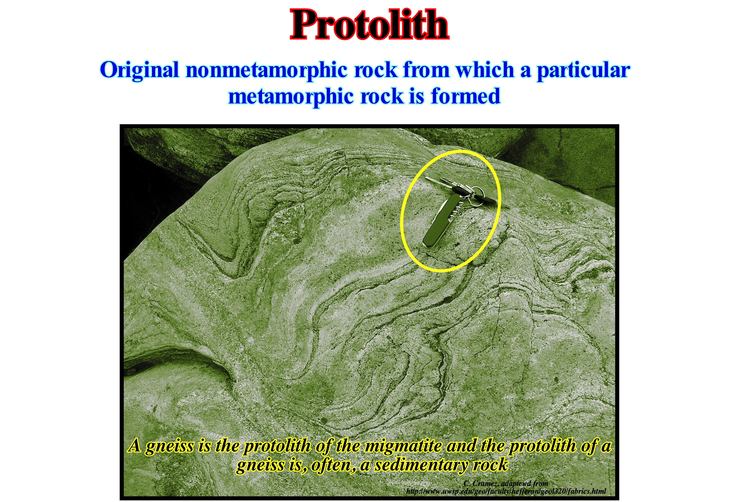
The term protolith refers to the precursor lithology of a metamorphic rock. The protolith of a shale is a clay. In fact, metamorphic rocks can be derived from any other type of rock due to changes in geological conditions (metamorphism), that is, due to variations in temperature, pressure and tectonic stress, and therefore have a large variety of protoliths. The identification of a protolith is one of the main objectives of metamorphic geology to better understand the history of a region composed of metamorphic rocks. Unlike metamorphic rocks, sedimentary rocks do not have protolith, because they are formed of sediments, whose origin is called provenance. In the same way igneous rocks do not have protoliths because they form from a magma. Do not forget that a metamorphic rock is the result of a protolith (of preexisting rock) that underwent a process called metamorphism. The term metamorphism means etymologically "change of form". During metamorphism, the protolith is subjected to high heat and high pressure (temperatures above 150-200° C and 1500 bar pressure), which causes profound physical and/or chemical changes. However, the protolith may be a sedimentary rock, igneous or an ancient metamorphic rock. Metamorphic rocks form a large part of the Earth's crust and are classified according to the texture, chemical and mineral assemblages that determine the metamorphic facies. The metamorphic rocks can be formed by simple burial, subjected to high temperatures and great pressures due to layers of overlying rocks. They can also form as a result of tectonic processes, such as continental collisions, which are at the origin of horizontal tectonic stresses, frictions and distortions. Metamorphic rocks can also form when heated by intrusions of a magma from the interior of the Earth. The study of metamorphic rocks (currently exposed to the Earth's surface following erosion and uplift) provides us with information on the temperatures and pressures that occur at great depths within the Earth's crust.
Proven Reserves (Hydrocarbons)............................................................................................................................Réserves prouvées (HC)
Reservas provadas / Reservas probadas (HC) / Nachgewiesene Reserven (HC) / 探明储量(慧聪) / Доказанные запасы (УВ) / Riserve dimostrate (HC) /
Quantities of hydrocarbons (P1) which from the analysis of geological data and engineering can be estimated in known reservoir-rocks with a certain degree of certainty and which can be, commercially, produced at a certain future date under the economic, production methods, and government regulation at the time of estimation.
See: « Reserves »
&
« Possible Reserves (HC) »
&
« Probable Reserves (HC) »
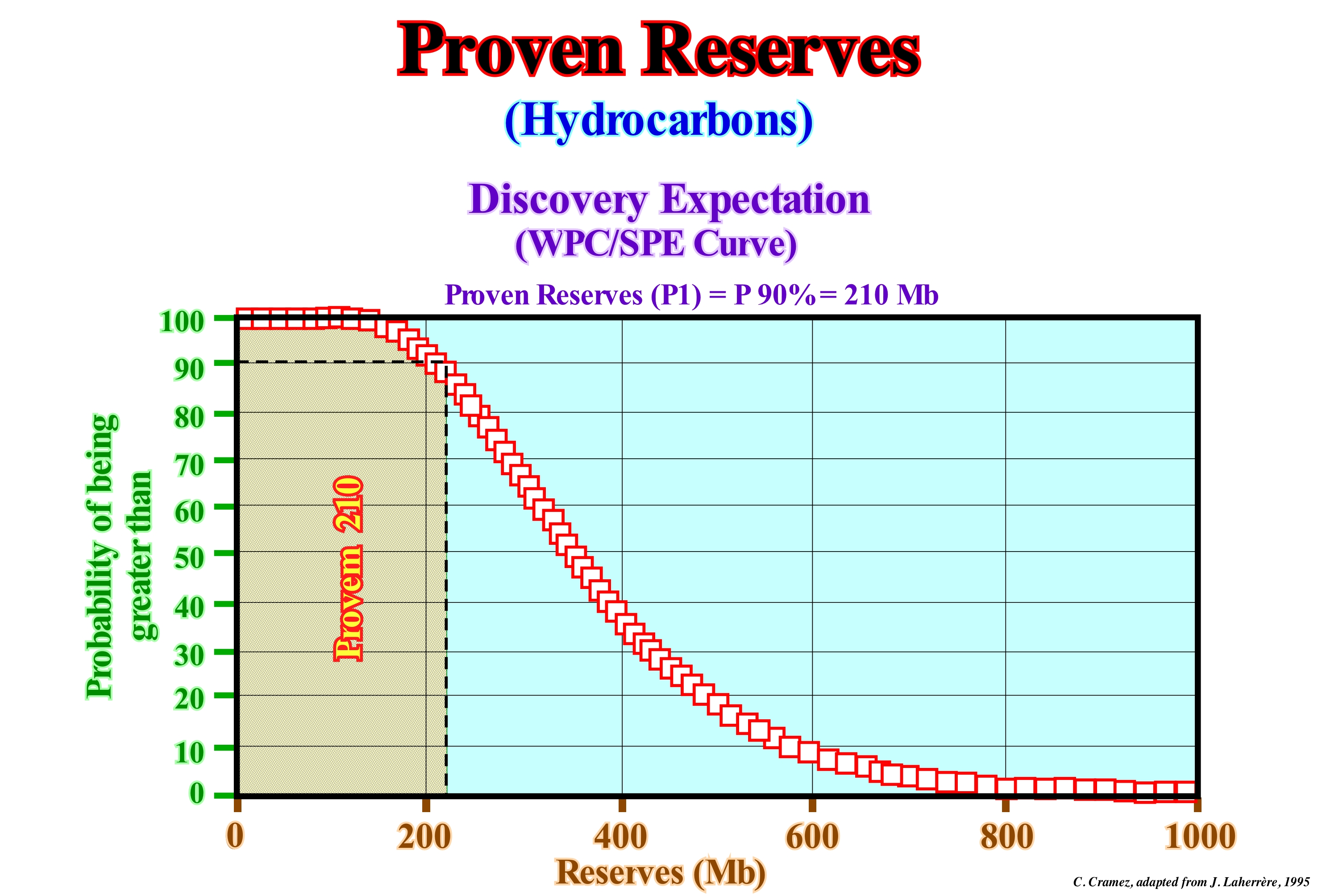
Proved reserves are quantified estimates of hydrocarbons (crude oil, natural bitumen, natural gas, natural gas liquids), that the geological and engineering analysis of a number of data has demonstrated with a certain degree of certainty that they can, from a certain date, be recovered, commercially, from reservoir-rocks known by methods profitable under present economic conditions. The expression "with a certain degree of certainty" implies that the probability of recovering the quantity, estimated as proved, is at least 90%. In this graph, proved reserves (for an exploration well), corresponding to a confidence level of 90%, are wax of 210 million barrels (210 Mb). Based on geological or seismic maps of the rocky reservoirs and without further research wells it is possible to add these other proven reserves (probable reserves and possible reserves), whose degree of certainty is evidently much smaller. It is important not to forget that in a petroleum company in 10 drilled wells, on average 6 to 7 are dry, meaning that geoscientists working in oil research have the right to make mistakes, since they bet always the least likely (a possibility of finding 30% oil, which is actually very good and rare, corresponds to a 70% chance of drilling a dry well). Of the ±50,000 oil fields (oil and gas) found to date, only ±500 fields are giants, corresponding to 1% of the fields. These 1% of the fields contain about 75% of the reserves. In oil exploration, geoscientists deal with uncertainty (probabilities) within a large domain (1-115,000 Mb), with large investments, large risks (great benefit) and large numbers, such as the boss of a casino and associated with same culture.
Provenance (Sediments)..................................................................................................................................................Provenance (Des sédiments)
Proveniência / Proveniencia (de los sedimentos) / Provenienz (Sediment) / 出处(沉积物)/ Происхождение (осадков) / Provenienza (sedimento) /
Place where the sedimentary particles originate or where the sediments originate.
See: « Sediment Influx »
&
« Progradation »
&
« Deposition (carbonate) »
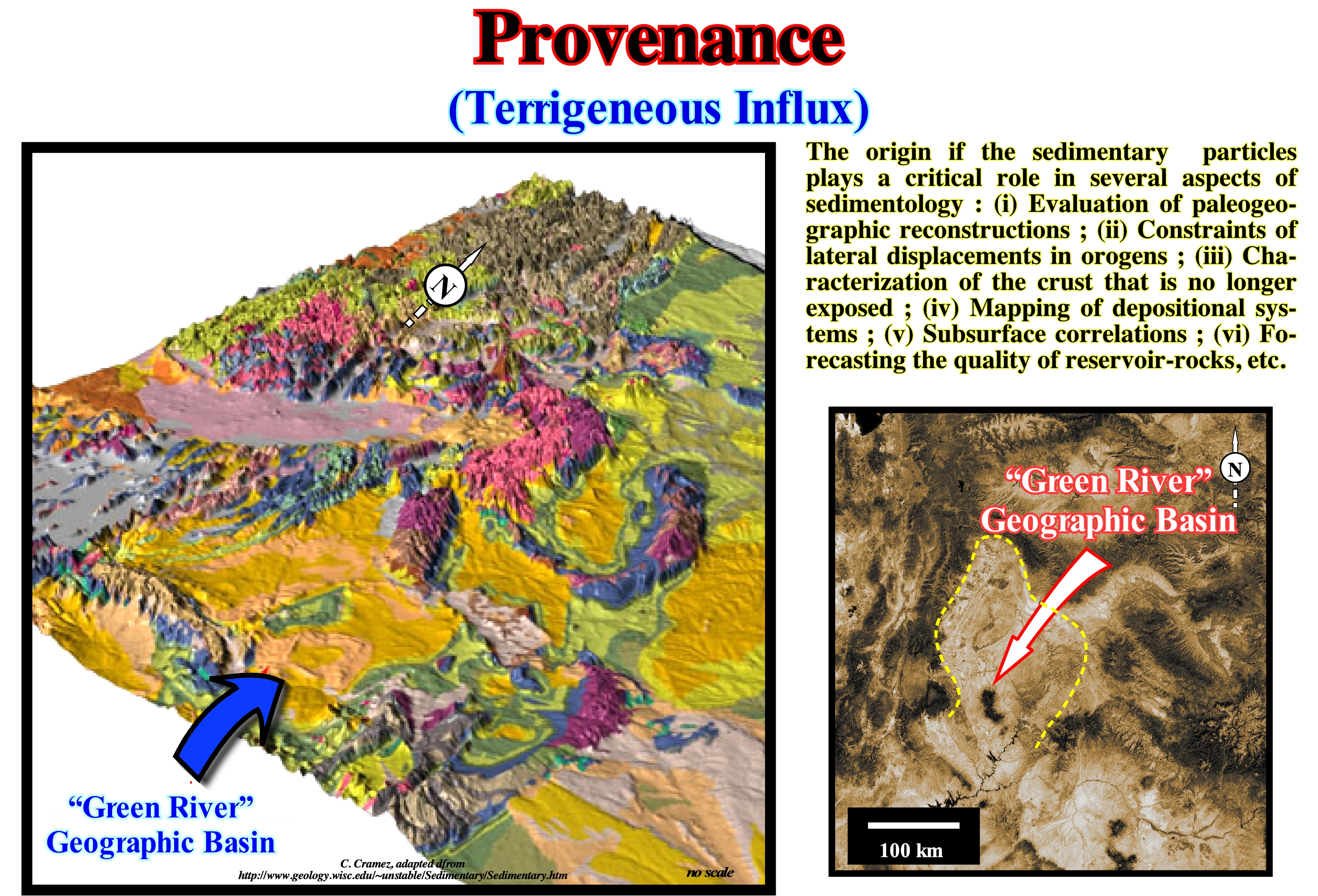
In geology, the concept of provenance, is the reconstruction of the origin of the sedimentary particles. As the Earth is not a static but dynamic planet and all rocks are subject to the transition between the three major types of rocks: (i) Sedimentary ; (ii) Metamorphic rocks and igneous rocks, which constitutes the "cycle of rocks". This cycle, which lasts for millions of years, is the main responsible for the renewal and transformation of the terrestrial lithosphere. Rocks exposed to the Earth's surface, sooner or later, are fragmented into sedimentary particles that are capable, under certain conditions, of providing evidence of the history of erosion of their source-rocks. The purpose of the sediment provenance study is to restore the geological history, whether it is tectonic, paleogeographic or paleoclimatic. This is, widely, used in conjunction with the study of exhumation histories, interpretation of drainage networks, and their evolution. In the geological language, "sedimentary provenance" refers, specifically, to the application of compositional analyzed to determine the origin of these sedimentary particles. This is, widely, used in conjunction with the study of exhumation histories, interpretation of drainage networks and their evolution, and forward modeling of paleoterrestrial systems (https: // en. wikipedia.org/wiki/Provenance_(geology). Taken together, these scientific studies help to characterize the trajectory between the source and the accumulation of clastic sedimentary particles within in a sedimentary basin. In recent years, the concept of provenance of the sedimentary sediment has undergone an authentic revolution due to the integration in the sedimentology of the isotopic methods that allow to better understand the origin of the sediments, not only those of detrital origin, but also of sediments of chemical origin. The first works in this sense were based on the geochronology of zircon grains by U-Pb (dating to uranium-lead, which is one of the oldest and most refined radiometric dating systems, which can be used to formed from about 1 million years ago to about 4.5 Ga with an accuracy of plus or minus 0.1 to 1 percent). These studies have shown that sediment recycling is much more complex and important than previously thought. Other isotopic systems have joined the U-Pb, which have the potential to determine different origins of sediments, which may overlap in age. The Eocene basin of the Green River (USA), for instance, illustrated in this figure, has been used for the study of the origin of the sediments, taking into account the effects of the climatic and paleohydrological changes, since this basin is surrounded by high the Archaean an Paleozoic high of the basement. Within the basin, as shown in the diagram block, tectonic uplift of the Late Cretaceous, which American geoscientists associate with the Laramide orogeny, can be differentiated. Among them are depressions (in yellowish tones) that represent the sedimentary basins, partially, filled by continental and lacustrine sediments. In this context, the origin of the sedimentary particles is, largely, dependent on the hydrographic network, i.e., on the river currents (energies and charges). On this subject, never forget that the whole body of moving water represents a certain energy, which is proportional to mass (flow) and to the square of its velocity. The faster a current, the greater the particle size carried by the suspended load (detrital material which has not been dissolved and is carried in suspension) and the bottom load (detrital material which has not been dissolved and is transported by mechanical forces of saltation, rolling or traction). The competence of a current is characterized by the dimensions of the particles it can carry. As the velocity of the current increases, the larger particles are transported as suspended load and larger quantities of bottom material begin to move, increasing the drag load. On the other hand, the larger the flow volume, the greater the amount of cargo it can carry, that is, the greater the capacity of the river.
(*) A natural cyclic phenomenon, continuous and infinite, involving the processes of transformation of rocks through time and occurring through erosion or weathering.
(**) The Laramide orogeny was a mountain-building process (orogenesis) that occurred in western North America and began at the end of the Cretaceous about 70/80 million years ago and ended between 20 and 55 million years ago. The cause and exact duration of this orogeny are controversial. The orogeny was produced by a series of pulses, alternated with periods of inactivity. The main result was the formation of the Rocky Mountains, but evidence of this orogeny is found from Alaska to northern Mexico, being the most eastern mountain of this Black Hills orogeny of South Dakota. (Https://es.wikipedia.org / wiki / Orogenia_Laramide)
Provisional Equilibrium Profile (River)....................................................Profil d'équilibre idéal (Fleuve)
Perfil de equilíbrio provisório / Perfil de equilíbrio ideal (río) / Ideal Gleichgewicht Profil (Fluss) / 理想的平衡剖面(河) / Идеальный профиль равновесия (река) / Profilo di equilibrio ideale (fiume) /
When the slope of the river is such that it allows, only, the water to flow and that all the sedimentary transport has disappeared. Under these conditions, the river has reached what can be called its definitive or ideal equilibrium profile.
See: « Regradation »
Proximal Onlap....................................................................................................................................................Biseau d'aggradation próximal
Bisel de agradação proximal / Bisel de agradación proximal / Proximale Onlap, Bevel Verlandung Proximal / 近端上超 / Ближнее подошвенное налегание / Onlap prossimale, Bisello d’aggradazione prossimale /
Onlap oriented in the opposite direction of sedimentary influx. Generally, a proximal onlap is oriented upstream. When a geoscientist speaks of a onlap, he is almost always referring to a proximal onlap.
See: « Distal Onlap »
&
« Continental Encroachment»
&
« Aggradation »
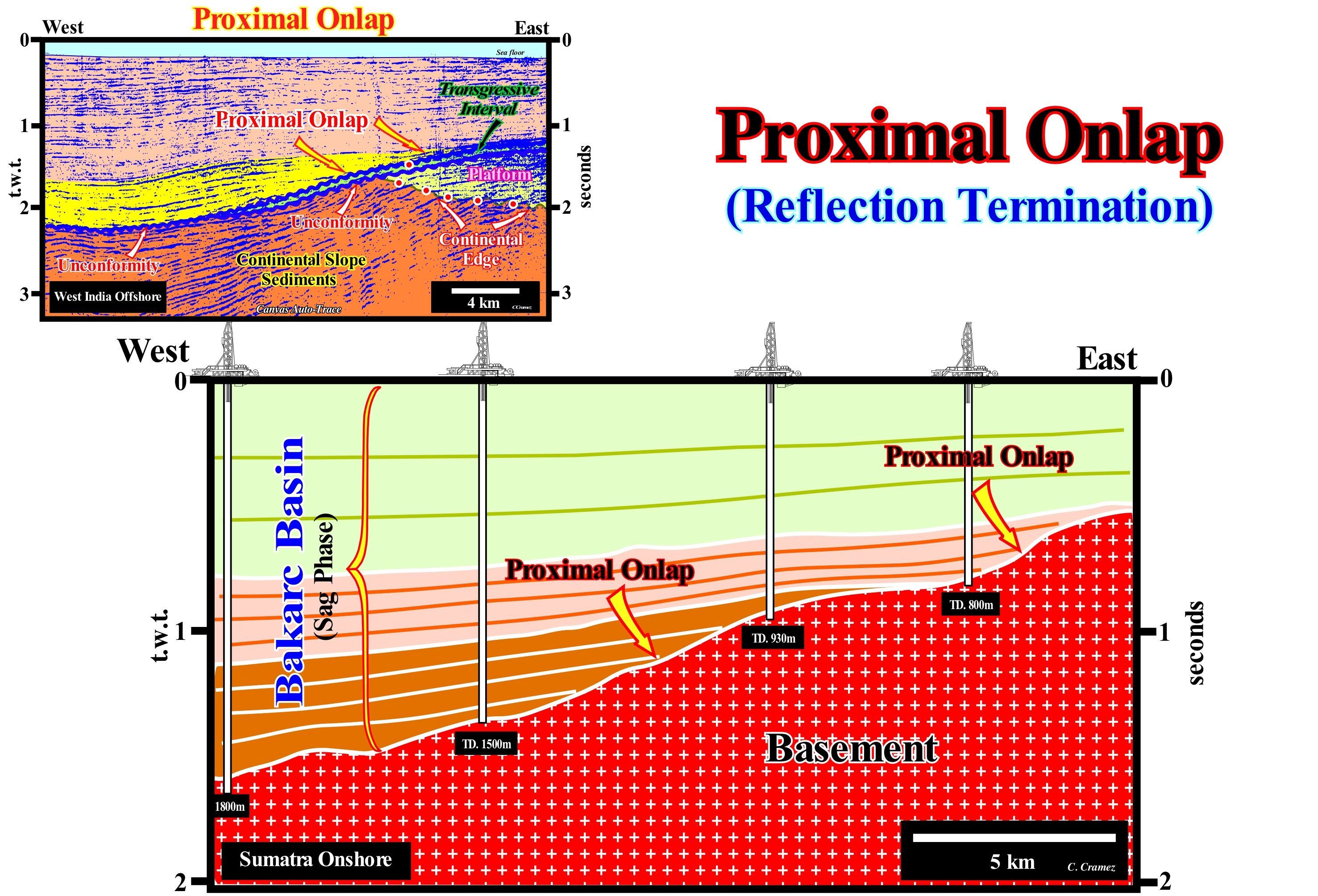
The Sumatra onshore (Indonesia), where the seismic line of this Canvas auto-trace was shot, from which the tentative geological interpretation was made, corresponds to a backarc basin of the classification of the sedimentary basins of Bally and Snelson (1980 ). Locally, above the basement, halfgrabens of the rifting phase can be evidenced. They were are covered by marine sediments of the sag phase. During the rifting phase, the subsidence, probably, due to the lengthening of the lithosphere, while during the sag phase, the subsidence was thermal. Obviously, this onshore developed within the Mesozoic/Cenozoic megasuture, which means that it developed in a geological context in which compressional tectonic regimes were and are still prevalent today. In the area of this tentative interpretation (where the rift-type basins are not visible), the sediments of the sag phase fossilized the basement (granite-gneiss) by onlapping, which in this case are proximal onlaps, once, of the terrigeneous influx came continent (located to the East). Taking into account the location of this onshore, it is evident that the sediments have been deposited in an back-arc basin and, in a regional line, a geoscientist should try to recognize the halfgrabens (rift-type basins) that developed during the lengthening of the lithosphere, in which, a priori, there must be a known generating petroleum subsystem*. As K. Popper (1934) said, "Theory precedes Observation". This is, particularly, true in the geological interpretation of seismic lines. If the interpreter does not know, a priori, i.e., starting from cause to effect, which is a backarc basin, he can spend months looking at the seismic lines, but he will never recognize it. Indeed, we do not see with the eyes, but with the brain (the eyes only serve to bring the light waves to the brain, where they are treated and analyzed). A geoscientist, like anyone else, to recognize anything, needs to know it. On the tentative interpretation of this Sumatra onshore Canvas auto-trace, three sedimentary intervals are considered in the sag or thermal phase. The lower has a, more or less, parallel internal configuration, in which proximal onlaps are obvious. They belong, probably, to two transgressive sedimentary intervals, deposited in association with marine ingressions induced by relative sea level rises (local sea level, referenced to any point on the Earth's surface, which may be the top of the continental crust or the sea floor). This means that relative sea level is the result of the combined action of the tectonics (subsidence, when the predominant tectonic regime is in extensional or uplift, when the predominant tectonic regime is in compressional) and absolute (eustatic) sea level, which is supposed to be global and referenced to the Earth's centre. The upper interval is regressive and was, probably, deposited during a continental encroachment subcycle, when the eustatic or absolute sea level fall. On the regional seismic lines, the reflectors of the upper interval should correspond to the low sloping progradations, which corroborate the conjecture that the post-Pangea regressive phase of continental encroachment cycle was deposited during an eustatic falling. On the tentative interpretation of a Canvas auto-trace of a detail of a West India offshore seismic line (divergent Atlantic-type margin), shown in the upper left corner of this figure, proximal onlaps are evident within the yellow colored interval. This onlaps fossilize the upper blue unconformity which, according to the stratigraphy patterns, was induced by a significant relative sea level fall, which put the sea level lower than the basin edge exhuming the continental platform or shelf (if the basin had a platform) and the upper part of the continental slope and with which are associated deep-water turbiditic depositional systems, which initiate a new sequence-cycle.
(*) In the petroleum systems classification of Magoon, L. B, and Dow, W. G., 1994, which describe the genetic relationship between the source-rock of an area and the associated oil and gas accumulations, three large families are considered as a function of the level of uncertainty: (i) Known Petroleum Systems (.), when there is a good geochemical correlation between the parent rock and the accumulations of oil or gas; (ii) Hypothetical Petroleum Systems (.), when geochemistry identified a source- rock, but there is no geochemical correspondence between the source-rock and oil accumulation and (iii) Speculative oil systems (?), where the existence of a source-rock or oil is postulated entirely on the basis of geological or geophysical evidence.
Proximal Turbidite.........................................................................................................................................................Turbidite proximale
Turbidito proximal / Turbidita proximal / Proximale Turbidit / 近端浊流沉积 / Проксимальныйтурбидит / Torbiditici prossimale /
One of the gravitational deposits of sand induced by the gliding of the delta front sands to the base of the delta slope, when it reaches a slope of more than 3° (the stability of the slope depends, among other things, on the water-depth), what prevents the delta from advancing seaward. The deposition of proximal turbidites decreases the delta slope angle, which allows the delta progradation to resume.
See: « Submarine Basin Floor Fan »
&
« Submarine Slope Fan »
&
« Lowstand Systems Tract »
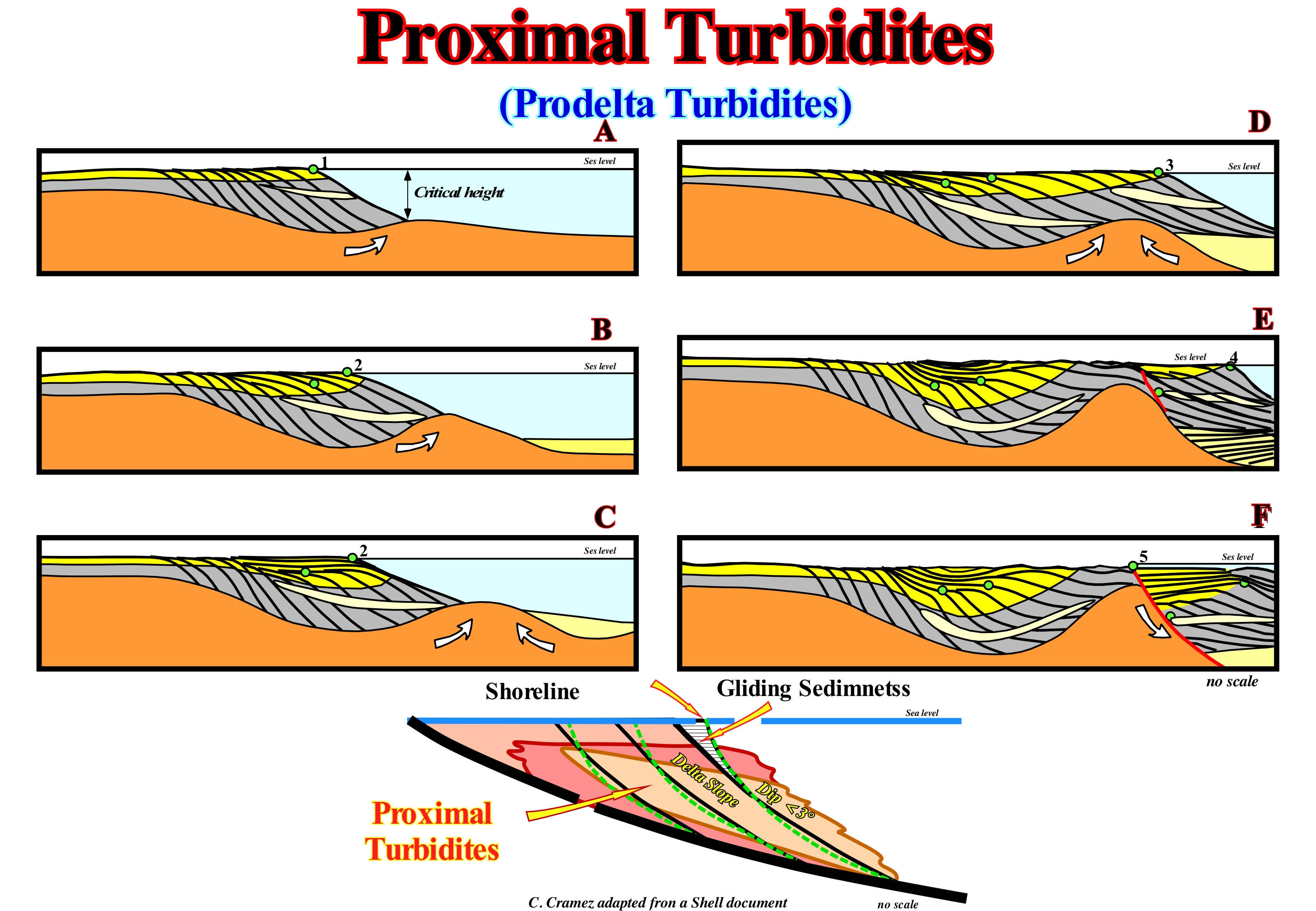
Turbidite deposits are induced by turbidity currents, which can be defined as sedimentary particles laden currents, which move rapidly down the coast (continental slope, delta or other) through water or other fluid. A turbidite current moves because it has a higher density than the fluid through which it flows. The driving force of a turbidity current derives from its sediment load, which makes the turbid water denser than the overlying water. Turbidity currents are examples of density or gravity currents, which include: (i) Ocean fronts ; (ii) Avalanches or landslides ; (iii) Lahars ; (iv) Pyroclastic flows, etc. The formation of proximal turbidites is associated with the development of delta systems, generally, developed under lowstand geological conditions, i.e., the lowstand prograding wedge (LPW) of the sequence-cycles, can be summarized as follows: (1) During the more or less long stability period of relative sea level, which occurs after a marine ingression (continentward displacement of the shoreline), the depositional coastal break of the depositional surface (green circle in this figure), which is more or less the shoreline, progrades seaward on a movable shaly substrate (stage A, in this figure), with a stable delta slope (certain cases may settle down on the upper part of the slope continental, when the basin has no continental shelf) ; (2) The bayline*, the sediments of the delta plain and the shoreline, prograde seaward, at the same time, as the prodelta shales are deposited ; (3) In the depocenter, the sediment thickness increases, due to local formation of a compensation subsidence induced by the lateral and vertical flow of the moving substrate (cause or effect of the vertical pressure σv, i.e, of the geostatic or lithostatic pressure σg minus the hydrostatic or pore pressure σp) ; (4) As σ3 is horizontal** and perpendicular to the shoreline (parallel to σ2), the mobile shaly substrate flows vertically and laterally seaward, which creates a mounded anomaly ; (5) The formation of this positive anomaly on the sea floor increases the angle of the delta slope, which, for a certain column of water, becomes unstable (critical angle) ; (6) Since the critical angle is reached, the sediments can no longer prograde seaward once the slope is unstable ; (7) As the delta slope is unstable, the sediments that reach the shoreline and a part of the delta front lose cohesion and collapse seaward, by gravity currents, to the base of the delta slope where they settle-down since the currents are decelerating ; (8) Since these proximal turbiditic lobes settle down at the base of the delta slope, the dip of the slope decreases, as the water-depth decreases (relative sea level is assumed to be in equilibrium) ; (9) Since the water-depth is less than the critical angle, the inclination of the delta slope again allows the sediment to prograde seaward as well as the shoreline (green circle) ; (10) This mechanism, which certain geoscientists designate, in Latin, "Agradate ut Progradamus" to emphasize the fact that onlapping allows an overlying progradations, is repeated several times until a significant relative sea level variation change the deposition conditions. In summary, it can be said within the three subgroups of sedimentary systems tracts forming the lowstand systems tracts group (LSTG), different turbidite types and facies can be recognized: (A) Within the lowstand prograding wedge (LPW: (a) Proximal turbidites ; (b) Shingled Turbidites ; (B) Within the submarine slope fans (SSF): (a) Submarine Canyon fills ; (b) Natural marginal dykes (levees) ; (c) Distal shaly facies of overbank deposits ; d) Channels or depressions fills ; e) Fine-stratified submarine slope fans ; (C) Within the submarine basin floor fans (SBFF) : a) Turbidite lobes b) Amalgamated turbidites ; c) Non-amalgamated turbidites; d) Channelling facies and e) Contourites.
(*) The concept of the bayline, which is the boundary between the coastal plain and the alluvial plain, was introduced in the sequential stratigraphy by Posamentier and Vail. They conjecture that delta deposition occurs when a stream of water, usually a river, encounters a water-body, almost motionless, and its speed diminishes almost instantaneously. For them the coastal plain is formed by seafloor progradation processes rather than by exhumation, which is well illustrated in this sketch. The sediments that accumulate on the coastal plain during shoreline progradation are part of what they called coastal wedge or coastal prism, which includes fluvial and shallow-water deposits. This prism has wedge shape and extends continentward by onlapping on the pre-existing topography. The upstream boundary of the coastal prograding wedge is the bayline, which can move upstream when the progradation of the shoreline is accompanied by aggradation.
(**) σ1, σ2, σ3, s are the axes of the deformation ellipsoid of the effective stresses.
Proxy (Program).......................................................................................................................................................................................................................................Proxy
Proxy / Proxy / Proxyserver / 代理服务器 / Прокси / Proxy /
An interpreter program that serves as an intermediary between two other programs to facilitate or control the exchange of information, as an interpreter that allows two people, who do not speak the same language, to communicate between them. In science, it is sometimes necessary to study a variable that can not be measured directly. This can be done by a proxy method, in which a variable, which correlates with the variable that interests us, but which we can not determine, is measured and then used to infer the value of the variable we are interested in. Proxy methods are particularly used in the study of the geological past and etyasia of the past, since direct measurements of temperature and sea level are not possible.
See: « Climatology »
Psammite....................................................................................................................................................................................................................................Psammite
Psamito / Psamita / Psammite (Sedimentgestein) / Psammite (沉积岩) / Псаммит / Psammite (roccia sedimentaria) /
Sedimentary rock resulting from sand consolidation. Synonym with Sandstone.
See: « Sand »
&
« Arenite »
&
« Granulometry »
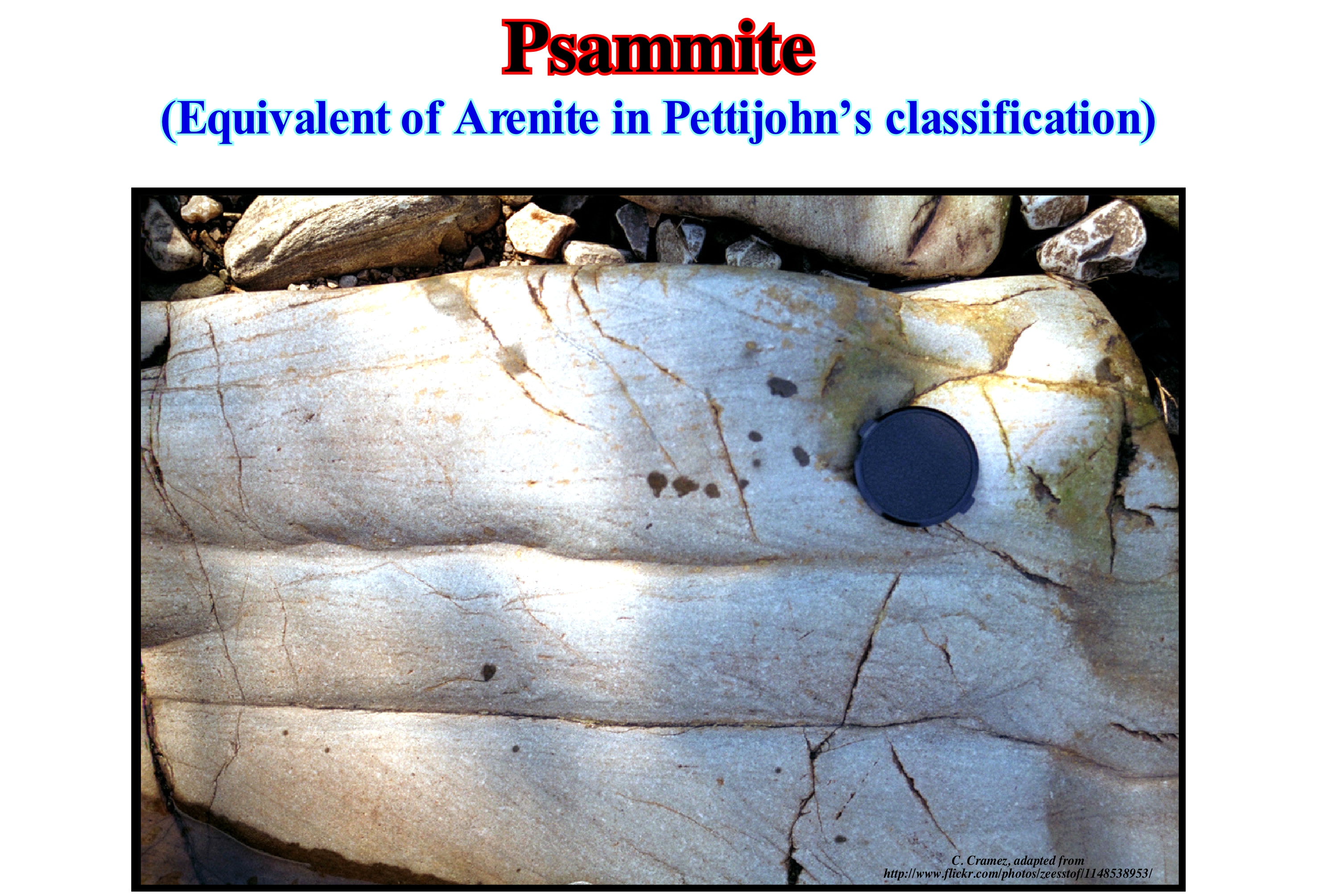
When a granite massif is subjected to erosion, a sandstone forms. Certain sandstone minerals during transport through water will undergo a hydrolysis, meaning that feldspar and biotite (black mica) will be dissolved, whereas quartz and muscovite (white mica) will remain intact. More a rock contains feldspar and biotite, plus its transport was short (feldspar > 25% it is an arkose), whereas, on the contrary, when transport is long there will be no feldspar and biotite and the final rock is psammite. The term psammite, which comes from the Greek "psammos" meaning sand, is a general term for a sandstone, often, designated to describe a metamorphosed rock unit with a sandstone protolith. An alternative term, more often used for nonmetamorphic sediments, is sandstone. Pettijohn, based on the size of the grains and avoiding the terms argilaceous and clay, which imply a chemical composition, proposed the following terms: (i) Pelite, which is a term of origin Greek, which is, usually, used for nonmetamorphic sediments, which form a clastic rock, in which the grain size is less than 1/16 mm (the Latin equivalent of lutite and term vulgar is muddy or clayey) ; (ii) Psammite is a general term for a sandstone, most often used to describe a metamorphic rock with a protolith, primarily, arenite; the equivalent term of Latin origin is sandstone and the term vulgar or common is sandy ; (iii) Psephite, which is a clastic rock with a particle size greater than 2 mm, such as a conglomerate or a breccia ; the equivalent Latin equivalent term is rudite and the common term is conglomerate. In the classification of Petttijohn, the terms with Greek origin (Psephite, Psammite et Pelite) are applied to metamorphic or anchi-metamorphic rocks, whereas the terms with a Latin root (Rudite, Arenite, Lutite) are mainly used for nonmetamorphic rocks.
Psammophile (Psammophitic, organism).............................................................................................................................Psammophile
Psamófilo / Psamófita / Psammophitisch / Psammophyle (或居住在沙) / Псаммофилы (организмы) / Psammophyle (che vivono sulla o nella sabbia) /
An organism living in a soil or in a sandy environment. The terms arenophilic and amophilic are, for some geoscientists, synonymous with the psamophile, though in the scientific literature they are more often used to designate environments and not organisms.
See: « Sand »
&
« Arenite »
&
« Sedimentary Environment »
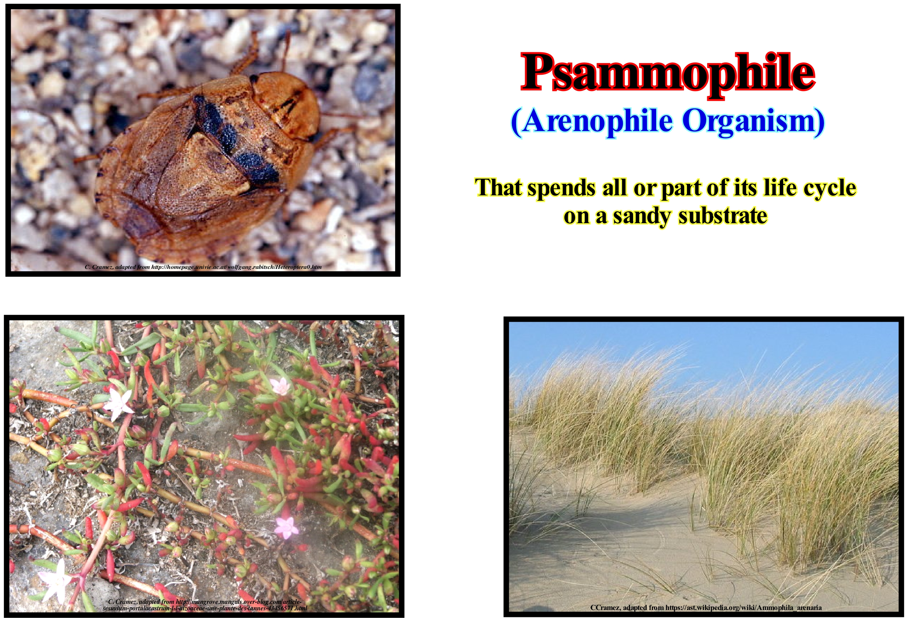
The psammophile organisms (arenophile or amophile) are among the most representative of the fauna of the desert. The only conditions of existence of psammophile organisms are created by the properties of sandy soils: (i) Their friability and mobility ; (ii) Their rapid heating during the day and the abrupt fall in temperature at night ; (iii) The dry (false water) of the upper layers and (iv) The concentration of humidity in certain deep areas. As a result of these conditions, psammophile organisms have a number of typical characteristics. The ability of psammophile organisms to move quickly (running, flying, jumping) is an important adaptation to food acquisition and defence against enemies, and it also allows them (animals) to have access to water points that many times, are at significant distances. Certain psammophile animals may bury themselves rapidly in the sand, for example, the Phrynocephalus or sand snake (a species of lizard in the Agamidae family) and others may even move within the sand or sandy sediments such as members of the suborder Polyhalite (containing most beetles, with about 300,000 species described). All psammophiles are xenophiles (adapted to lose little water). The most typical psammophiles are the beach fleas (Sarcopsylla penetrans), dark beetles, Polyphaga, Solifugae, spiders, scorpions, certain Eremias, Phrynocephalus, sand snake, sand cat, etc. In this figure (on the right) this succulent plant with small violet flowers was initially classified by Carl von Linné in the genus Portulaca. Its salt tolerance makes it a better adapted to very salty soils. She is also a psammophile and she supports temporary floods. The Menaccarus arenicola (right photograph) is a typical psamophyta known only in one place in Austria (in the Marchfeld sand mountains, was no longer found since 1959).
Psephite.....................................................................................................................................................................................................................................................Pséfite
Psefito / Pséfita / Psephite (Sediment oder Sedimentgestein) / Psephite (沉积物或沉积岩) / Псефит / Psephite (sedimenti o roccia sedimentaria) /
Term of Greek origin designating a clastic rock with a particle size greater than 2 mm, as a conglomerate. This term is equivalent to rudite (term of Latin origin), although psephite is more, commonly, used to designate one that underwent a certain metamorphism.
See : « Alluvial Fan »
&
« Arenite »
&
« Granulometry »
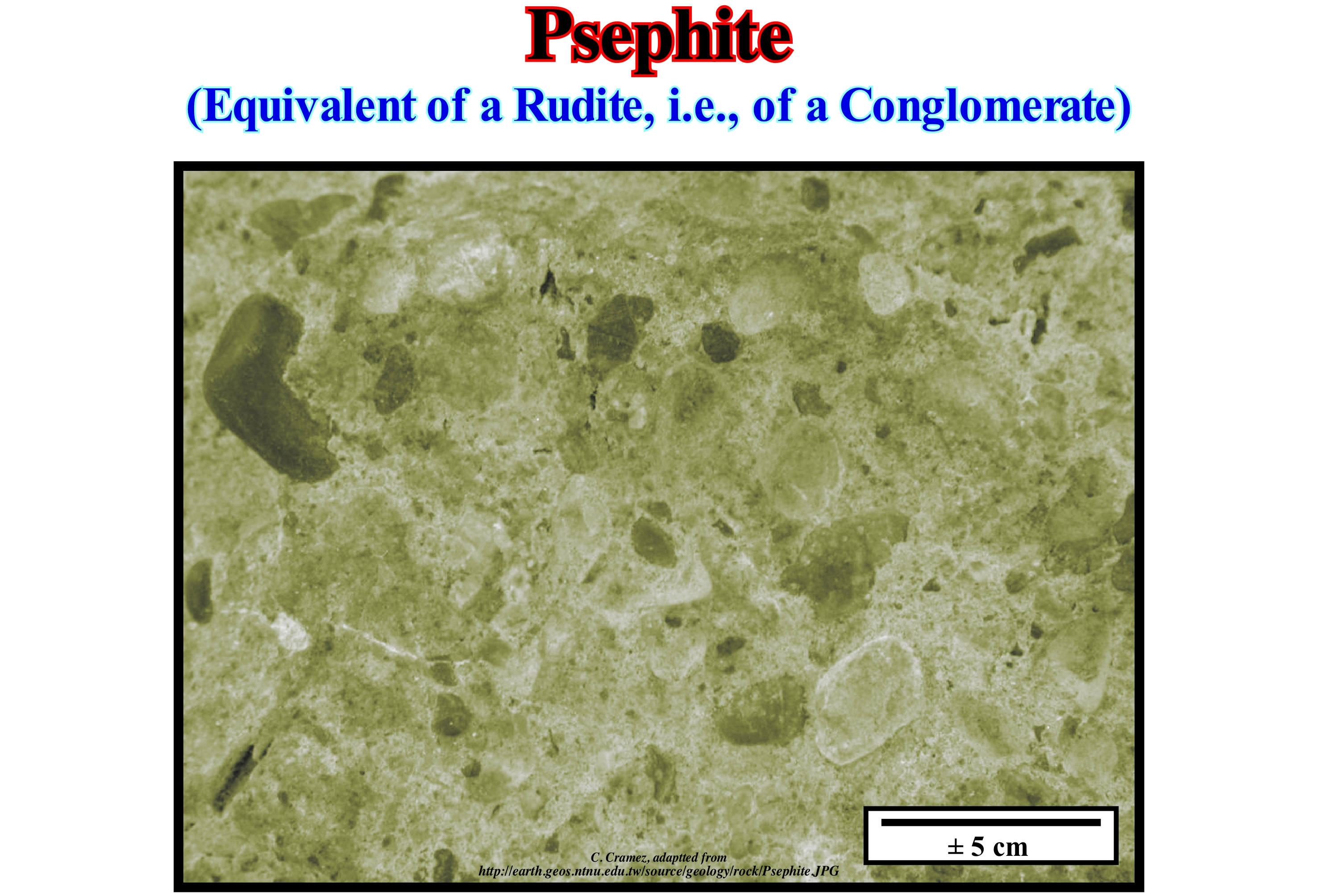
Pettijohn proposed a classification of clastic sedimentary rocks in which, to avoid confusion, avoided the terms, usually, used to designate the sedimentary particles such as clay. In fact, it is enough to read an article on sedimentology to verify that most geoscientists use the term "clay" in a wrong way to designate a rock, when that term designates either a mineral or a sedimentary particle (clay is a family of hydrated, silico-aluminous minerals with very low crystallinity and very small dimensions less than 1/256 mm or 4 μm in diameter, such as kaolinite, smectite, montmorillonite, illites, etc.). Pettijohn, based on the size of the grains and avoiding the terms argilaceous and clay, which imply a chemical composition, proposed the following terms: (i) Pelite, which is a term of Greek origin, which is usually used for non-metamorphic sediments, which form a clastic rock, in which the grain size is less than 1/16 mm (the Latin equivalent term of lutite and term vulgar is muddy or clayey) ; (ii) Psammite is a general term for a sandstone, most often used to describe a metamorphic rock with a fundamentally arenite protolith (the equivalent term of Latin origin is sandstone and the term vulgar or common is sandy) ; (iii) Psephite, which is a clastic rock with a particle size greater than 2 mm, such as a conglomerate or a breccia (the equivalent Latin equivalent term is ruddy and the common term is conglomerate). In the classification of Petttijohn, the terms with Greek origin (Psephite, Psammite et Pelite) are applied for metamorphic or anchimetamorphic rocks, whereas the terms with a Latin root (Rudite, Calcarenite, Lutite) are, mainly, used for nonmetamorphic rocks. The anchimetamorphic zone, as proposed by Kubler (1967 and 1968), corresponds to an increase in the crystallinity of the illite.
Pteropod......................................................................................................................................................................................................................................Ptéropode
Pterópodo / Pterópode / Thecosomata / 有殼翼足亞目 / Крылоногие моллюски / Thecosomata /
Small marine gastropod of the subclass Opisthobranchia (Mollusca phylum), characterized by having a modified foot to form a pair of parapods used for swimming. Pteropods, most of which are less than 1 cm long, live at or near the surface of the sea.
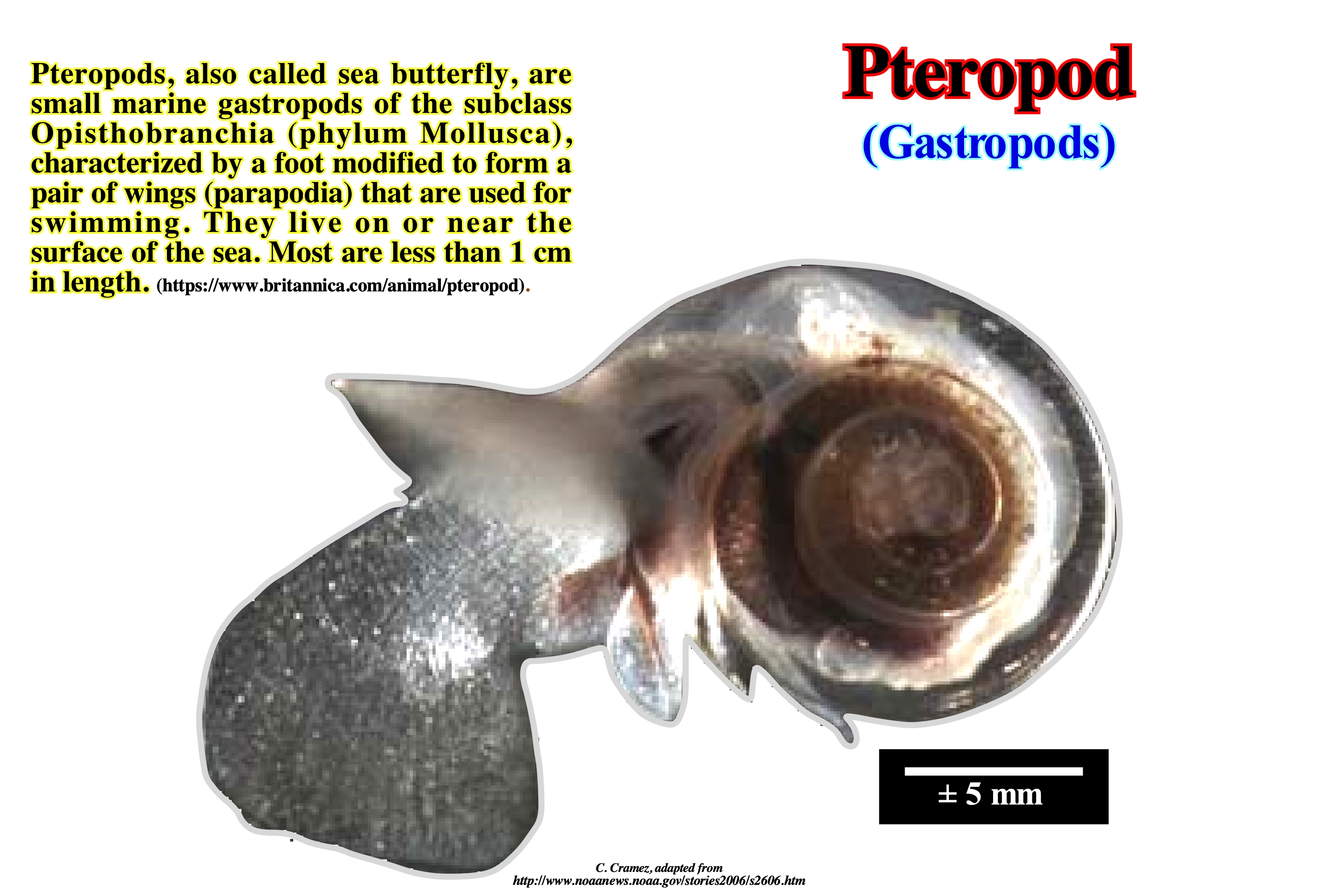
The term pteropod, which comes from a Greek word meaning "wing-foot", is currently applied to denote two different taxonomic groups of marine pelagic swim snails, sea slugs, opisthobranch marine gastropods (characterized by having a very small shell or non-existent and an absent mantle). The term "Pteropoda" no longer has a scientifically accurate use, but the vernacular name "pteropod" is still often used. This term is applied either to designate the butterflies of the sea of the clade Thecosomata and Gymnosperm (sea angels). The Thecosomata have a shell, while the Gymnosomata ("naked body") do not. The two clades are, in fact, not very closely related, despite a superficial resemblance. Both are pelagic, small and transparent, and both swim with wings in the form of feet (parapodia) that leave their bodies. The Pteropoda group was proposed by George Cuvier in 1804. However François Peron and Charles Alexandre Lesueruri consider that the group was not very big included the opisthobranch rate, the rate Heteropoda and even the rate Ctenophora. Finally, in 1810, the same authors divided the whole group into two separate groups: (a) Those with a shell and (b) Those without a shell. This figure illustrates pteropods (Hellenic Lamacina), by definition swimmer, which has a shell made up of aragonite, which is an important source of food for young salmon in the North Pacific. These snails float in the water freely, and are drawn by the sea currents. This led to a series of adaptations of their bodies. The shell and gills disappeared in several families. Its feet took the form of two wing-lobes, or parapodia, which propel this creature through the sea by slow movements like the wings. They are quite difficult to observe, since the shell (when present) is largely colourless, very brittle and generally less than 1 cm in length.
Push Moraine...................................................................................................................................................................................................................Moraine Poussée
Moreia de Impulso / Morena de empuje / Thrust Moräne / 推力碛 / Морёна напора / Morena di spinta /
Moraine formed by the glaciers that thin and that thicken again. The presence of an impulse moraine brings out a climate that becomes colder after a, relatively, warm period. The material that had been deposited is pushed and piled up as the glacier advances (thickens). As most of the material of the push moraine is deposited by gravity, there are important differences in the orientation of the fragments of the rocks within the moraine. An important feature that allows the identification of a push moraine is that the fragments have been pushed and lifted from their original horizontal positions.
See: « Moraine »
&
« Glacier »
&
« Ground Moraine »
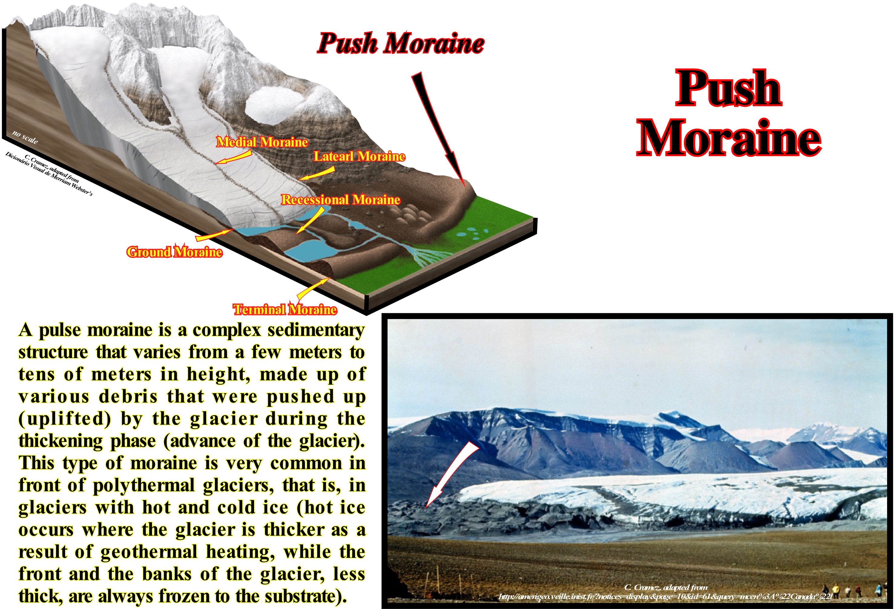
This photograph, taken by B. F. Molnia, illustrates the impulse moraine that blocked the mouth of the Russel fjord (Alaska). This moraine is composed of sediments that were transported along the base of the glacier, although some of these sediments may be in direct contact with the rocks of the fjord wall. The vast majority of impulse moraines are found in the, more or less, horizontal plains located at great latitudes and formed during the different phases of the Quaternary glacial age. They are found in the plains of North America, Siberia, and Northern Europe. They formed during the cold periods (glacial phases), when glaciers thickened and advanced, covered a large part of North America and Europe. This type of moraine is best developed in front of polythermal glaciers, that is, in glaciers with hot ice (when ice is thicker due to geothermal heat) and cold (ice below melting point pressure or dry ice). In some regions, impulse moraines may be recognized with more than one glacial phase or different generations, formed during a single glacial phase. Once the glaciers advance (thicken) and recede (thin), some of these moraines are destroyed as the glacier advances. Most of these moraines, which reach more than 100 km in length and several hundred meters in height, were formed during the last or the penultimate phase of advancement of the glaciers, i.e., between 110 and 100 ka and between 238 and 128 ka respectively.
Pyroclast (Material)............................................................................................................................................................................................Pyroclastique (Matériel)
Piroclástico / Piroclástico (material) / Vulkankrater / 火山碎屑 / Пирокласт / Piroclastico /
General term for all particles ejected by volcanoes. Synonym with Tephra.
See: « Tephra »
&
« Vulcanism »
&
« SDRs (seaward dipping reflectors) »
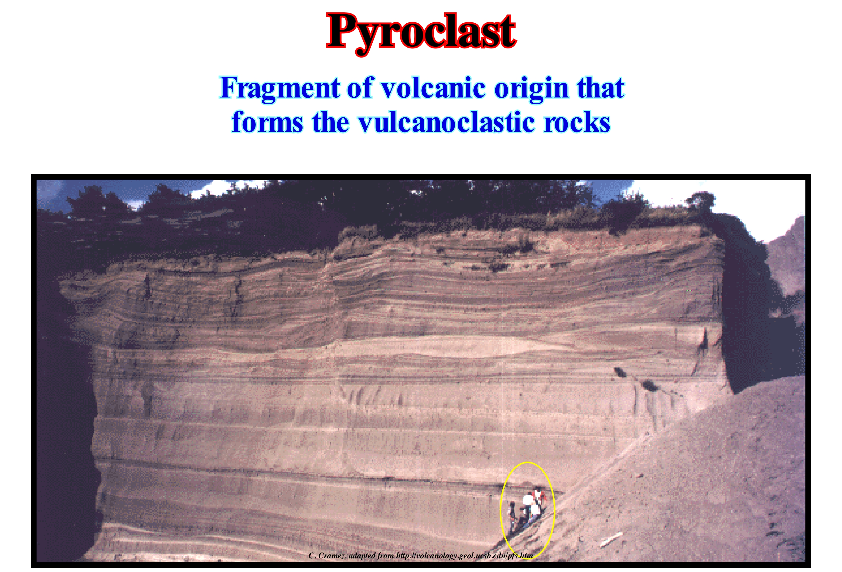
This photograph was taken during a tour of Prof. Schmincke with his students in 1980. It is interesting as it shows the pyroclastic flows (the thicker and more massive layers exhibiting wavy geometry with crossing stratification) in the pyroclastic quarry of the "Laacher See" volcano in Germany. Pyroclastic flows are a very particular type of gravitational gravitational flow. They are very special fluids, which have certain properties such as density and viscosity that change as they move, unlike other fluids like, water or air, in which the density and viscosity vary very little, if not at all, when they move. The driving force of a gravitational sediment flow is, of course, the action of gravity on the sedimentary particles. The movement of the sediments displaces the interstitial fluid (gas or liquid mixed with the particles), which together with them form the flowing mass flowing under the action of gravity. Particles with different velocities behave, differently, within the flow. The small particles tend to couple with the gas phase due to the drag effects, and thus they tend to increase the transport capacity of the flow. The matrix of the gas-particle phase is almost always turbulent and traverses the most important fragments. Fragments with higher velocities tend to migrate to the flow base, which increases the concentration of the particles and causes a significant increase not only in the total density, but also in the viscosity. In the seismic lines, the sub-aerial pyroclastic deposits, that accompanied the break-up of the supercontinents, in particular of the Pangea and Rodhinia are recognize without difficulty. They form very thick seismic intervals formed by packages with internal configurations divergent towards the sea. This means that the pyroclastic flows and, above all, the sub-aerial lavas gradually thin out continentward as they move away from the expansion centres. On the other hand, due to the overload of more recent flows, they incline, progressively, seaward.
Pyton...........................................................................................................................................................................................................................................Piton abyssal
Espigão Abissal / Espigón abisal / Piton abyssal / 冰锥深海 / Глубинный пик / Piton abissale /
Peak or mountain that rises from the abyssal plain but does not reach the surface of the sea (sea level), i.e., that does not form an island. Typically, abyssal pytons are extinct volcanoes that emerge, abruptly, from the abyssal plain and are, usually, under a water-depth between 1,000 and 4,000 meters. Synonym with Submarine Abyssal Mount.
See: « Abyssal »
&
« Abyssal Plain »
&
« Mid-Oceanic Ridge »
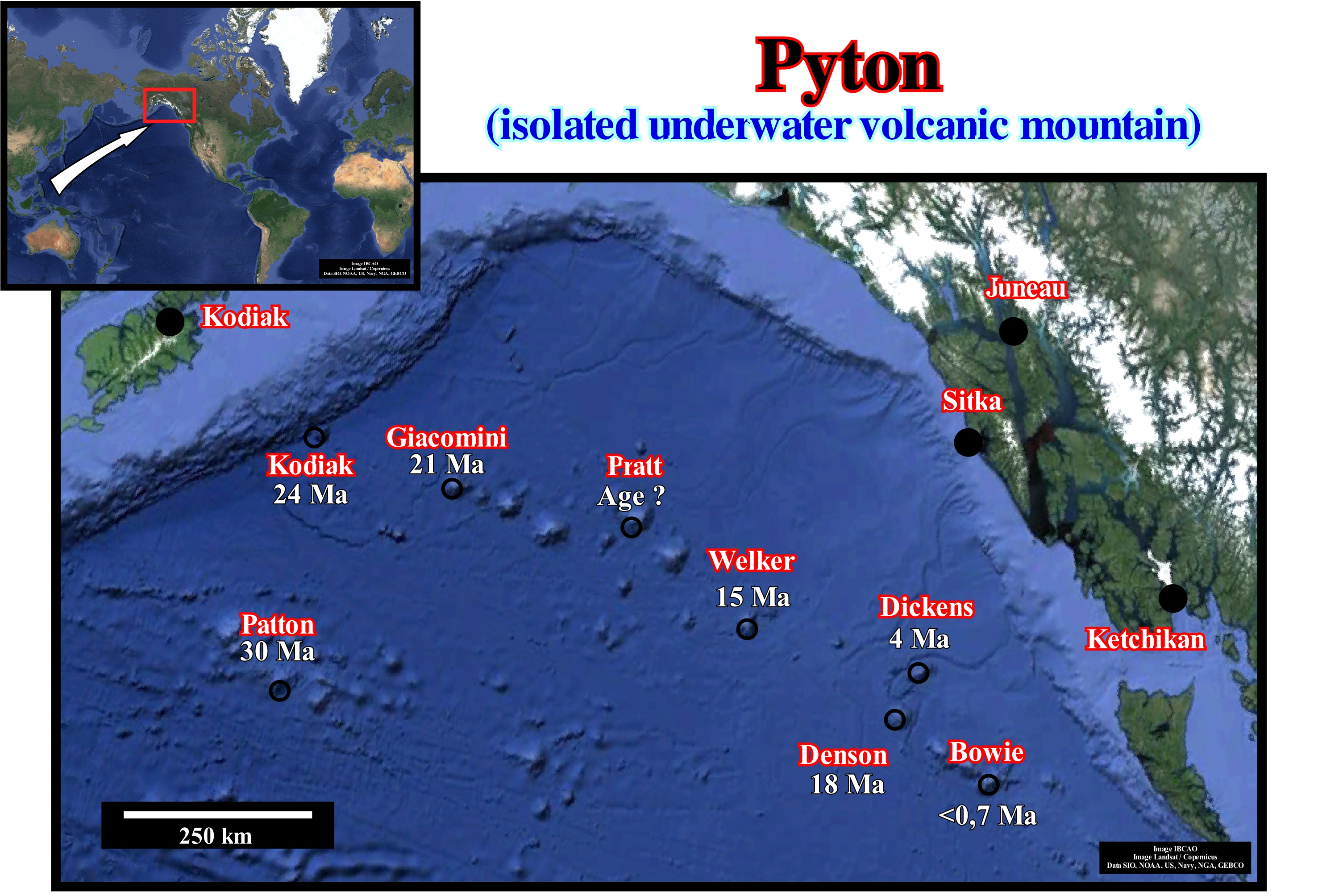
Peak-ending high hills and mountain ranges are not found only in continental areas. Contrary to popular belief, some of the world's tallest and highest mountains occur in the oceans. The mountains that lie under water are called submarine mountains that rise above the ocean floor. The more or less isolated mountains that rise from the abyssal plain and which, generally, have a conical shape, such as those illustrated in this figure, are called by some geoscientists abyssal python. Many of these spikes are extinct volcanoes, which formed above hot spots*. As illustrated in the Gulf of Alaska, many abyssal pytons have risen from the seabed, some of which are about 30 Ma. Among them the Patton pyton, which is about 3,000 meters high and 30 km wide, almost the sea level, since its top is under a water slide of about 180 meters. This python was formed as an submarine volcano about 30 million years ago, off the coast of Washington state not far from where it is today. Over time, the Patton pyton was moved out (west) from the hot spot that originated it, by the movement of the Pacific lithospheric plate. Other volcanoes formed above the same hot spot, which today form a chain of spikes whose age decreased from west to east. One of the spikes, the Bowie, which is the latest one is about 700 ky. Although they have been created by hot spots, they have characteristic sizes, shapes and volcanism. Deep corals, sponges, fish and many marine species inhabit the abyssal pythons, which was totally unknown a few years ago.
(*) Currents of rising magma, rising from the deep parts of the Earth and flowing through the crust to erupt on the surface or on the sea floor.
