Coastal Onlap Curve...................................................................................Courbe des biseaux d'agradation côtiers
Curva dos biséis de agradação costeiros / Curva de los biseles de agradación costera / Costal Onlap Kurve, Gebogene Fasen von Küsten Verlandung / 沿海超覆曲线 / Кривая береговых подошвенных налеганий / Curve delle variazioni eustatiche del livello del mare, Curva di bisellos d’aggradazione costieri
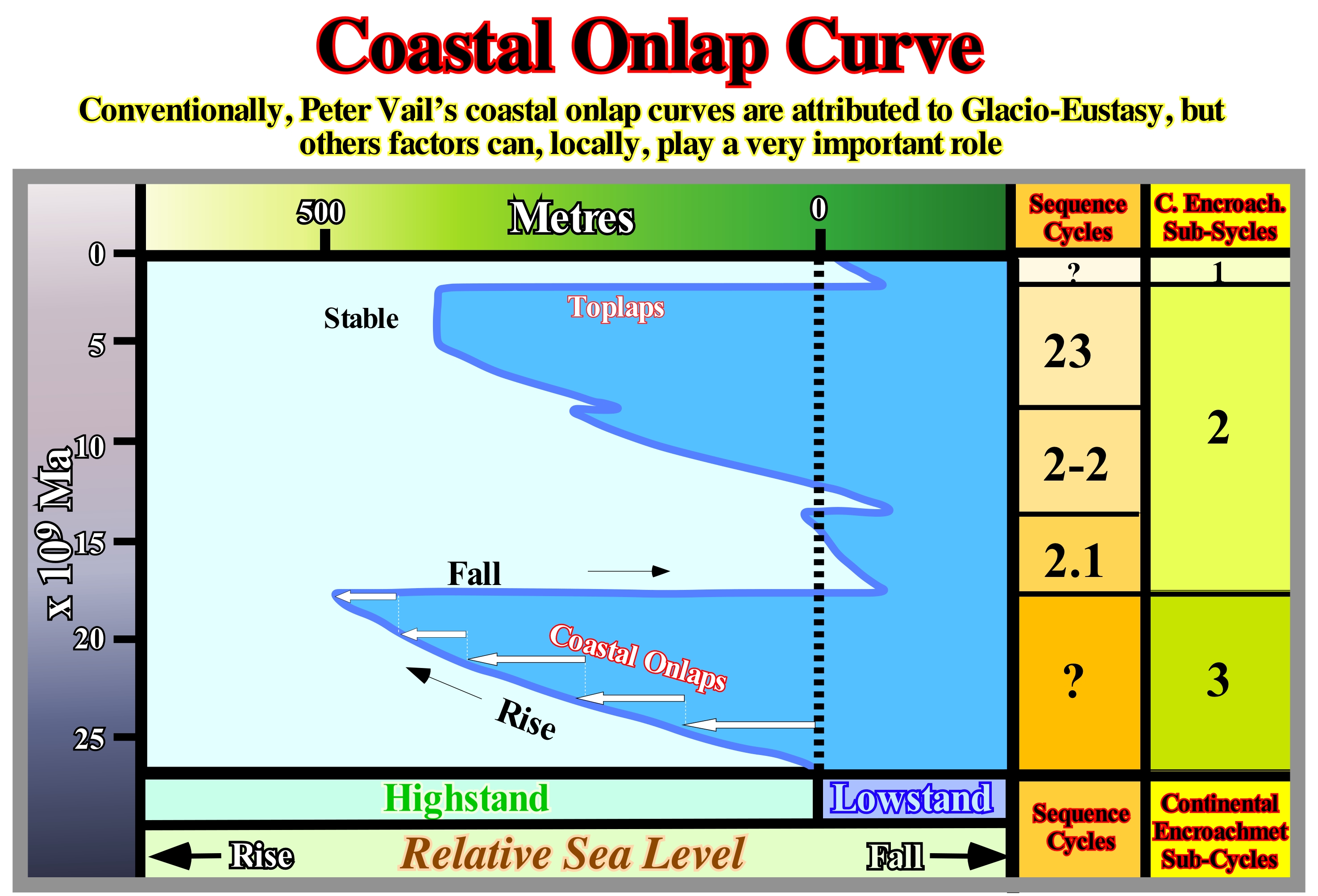
Chronostratigraphic diagram of coastal onlaps. It expresses the temporal succession of stratigraphic events. A relative sea level rise implies a migration of the coastal onlaps continentward. In this type of diagram, hiatus and intervals characterized by a starved sedimentation correspond to triangular zones pointing towards the continent.
See: « Aggradation »
&
« Relative Sea Level Rise »
&
« Onlap »
In a coastal onlap curve, the vertical scale is geological time (in millions of years, i.e., 109 Ma) and the horizontal scale is metric. This type of diagram (chronostratigraphic) stresses, particularly, the continental encroachment (coastal or marine), when relative sea level rises (local sea level referenced either to the sea floor or the base of the sediment and which is the result of combined action of tectonics and the absolute or eustatic sea level supposed global and referenced to the Earth's centre). Onlaps (coastal or marine) with aggradation and positive continental encroachment underline a marine ingression, i.e., a relative sea level rise. When a marine ingression (relative sea level rise) is in acceleration, i.e., is, increasing increments of the sea level, the aggradation between coastal onlaps (deposited during the stability period of relative sea level occurring after a marine ingression) is increasing, as is the case during the transgressive interval (TI) and the lowstand prograding wedge (LPW) of a sequence-cycle. When the marine ingression is in deceleration (increments smaller than the previous one), as is the case in the marine ingressions inducing the deposit of the highstand prograding wedge (HPW) of a sequence-cycle, the aggradation between each coastal onlap is, progressively, smaller. Toplaps (by no deposition or by erosion) underline relative sea level rises in deceleration (presence of aggradation and progradation, although the progradation is predominant) or even small relative sea level falls, that do not put the sea level lower than the basin edge. A marine ingression produces, mainly, a continentward displacement of the shoreline. Such a displacement is function not only of the amplitude of relative sea level rise, but also of the pre-existing topography. This means that there is, practically, no deposition during a marine ingression. On the other hand, it can also be said that a marine ingression does not create any unconformity (erosional surface) but just a small ravinment surface (reworking by the waves of the pre-existing topography with small residual deposits). During stability periods of relative sea level occurring after marine ingressions in acceleration (transgressive interval and lowstand prograding wedge) or in deceleration (highstand prograding wedge), there is, mainly, deposition of outbuilding depositional systems that displace seaward the shoreline, which corresponds, roughly, to the coastal break-,up of the depositional surface. Aggradation is well visible in the transgressive intervals (TI), but relatively small and often under seismic resolution in the lowstand and highstand prograding wedges. In this coastal onlap curve (South Labrador offshore), four significant relative sea level falls are evident. They induced basinward and downward displacements of the coastal onlaps (negative aggradation). Such displacements have caused exhumation of the shelf and of the top of the continental slope, creating erosional surfaces (unconformities) that limit the stratigraphic cycles, in particular, of the sequence-cycles. In the area in which this diagram was constructed, there are at least four stratigraphic cycles, induced by four eustatic cycles. Most geoscientists consider the following orders of eustatic cycles: (i) 1st order, duration greater than 50 My ; (ii) 2nd order, duration between 50My and 3-5M ; (iii) 3rd order, duration between 3-5 My and 0.5 My ; (iv) 4th order, duration between 0.5 M and 0.08 M ; (v) 5th order, duration between 0.08 My and 0.03 My and (vi) 6th order, duration between 0.03 My and 0.01 My. Since the order of eustatic cycles is determined, stratigraphic cycles may be sequence-cycles, when the duration of each associated eustatic cycle varies between 0.5 My and 3-5 My or continental encroachment sub-cycles if the duration of eustatic cycles varies between 3- 5 and 50 My. The results of exploration wells drilled in this area corroborate the interpretation illustrated here: (i) Three continental encroachment sub-cycles (1, 2, 3) ; (ii) Within the continental encroachment subcycle n°2, three sequence-cycles are evident ; (iii) Within the continental encroachment sub-cycles n°3 and n°1, the resolution of the coastal onlap curve does not allow to show the sequence-cycles composing it.
Coastal Plain.......................................................................................................................................................................Plaine côtière (Plaine littorale)
Planície costeira / Planicie litoral, Planicie costera / Litoralebene, Küstenebene / 沿海平原 / Прибрежная равнина / Pianura costiera /
Depositional surface upstream of the shoreline whose altitude is near the sea level.
See: « Shoreline »
&
« Depositional Coastal Break »
&
« Bayline »
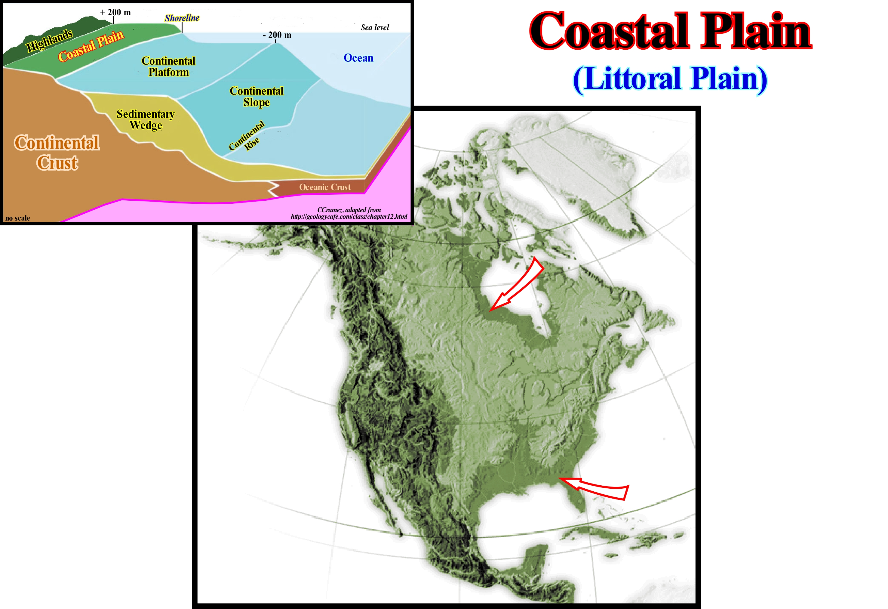
In this particular case (United States), between New Jersey and Texas, the coastal plain that has here a width of about 300 km, corresponds to a low and broad plain adjacent to the ocean, in which the strata are horizontal or, slightly, inclined seaward. It is made up of recent sediments that prograde seaward or were exhumed during the fall of the absolute (eustatic) sea level fall (supposed global and referenced to the Earth's centre), induced by the Quaternary glaciations. The sediments were, progressively, submerged by the absolute sea level rise as the ice melted. The sea level can be absolute (eustatic) or relative. The relative sea level is local and referenced to the base of the sediments (top of the continental crust) or to any other point on the Earth's surface, as the sea floor. The relative sea level is the result of the combined action of absolute (eustatic) sea level and tectonics (subsidence of the sea floor when the sediments are lengthened by an extensional tectonic regime, or uplift of the sea floor when the sediments are shortened by a compressional tectonic regime). In the northern part, the isostatic uplift (uplift of the land, previously, buried by the weight of the ice caps deposited during the last glacial period, since the ice melted) also contributed to the formation of the coastal plain. In sequential stratigraphy, the position of the inner boundary (upstream) of the coastal plain, which corresponds to the bayline , limits the coastal plain from the alluvial plain. The outer limit of the coastal plain is, practically, the shoreline, which allows to define many different sedimentary contexts. For the followers of sequential stratigraphy, the coastal plain is formed by processes of progradation of the sea floor rather than by exhumation. The sediments that accumulate in the coastal plain during the progradation of the shoreline are part of what is called "the coastal wedge or coastal prism" (Posamentier & Vail), which includes fluvial and shallow-water deposits. The coastal prism is wedge-shaped and extends continentward by onlapping on the preexisting topography till the bayline. In general, when the geological conditions are of highstand (sea level above the basin edge), the outer limit of the coastal plain is very far from the basin edge (which in such conditions coincides with the continental edge): the basin has a shelf. This is true, particularly during the transgressive interval (TI) of a sequence-cycle (lower subgroup of the upper highstand systems tracts group), since the relative sea level rises in acceleration. That means the successive increments of a marine ingression are increasingly important and the associated sedimentary regressions are increasingly smaller. In fact, a significant marine ingression is not done in continuity, but by steps (increments) separated by stability periods of relative sea-level: (i) Relative sea level rises ; (ii) Relative sea level stabilizes, (iii) Relative sea level rises again, etc., etc. However the steps may be in acceleration or deceleration. In the first case, the steps are increasingly important, while in the second, they are increasingly smaller. On the other hand, during the steps of a marine ingression, the shoreline moves continentward with the formation of a ravinment surface on the pre-existing topography. During the stability period of relative sea level between steps, the coastline moves seaward (outbuilding) as sedimentation is done by progradations with a, more or less, dipping clinoform. During the deposition of a highstand progradating wedge (HPW), which is the upper sub-group of highstand systems tracts group, the relative sea level rises but decelerating, which means that the increments of marine ingressions are increasingly smaller and the associated sedimentary regressions increasingly important. If, at the beginning of the lowstand prograding wedge (LPW), the shoreline (outer limit of the coastal plain) is too far from the basin edge, it will, gradually, move seaward. This displacement reduced the distance between the coastal plain and the basin edge. The size of the continental shelf decreases until be, completely, fossilized by the progradations of the highstand prograding wedge. Since then, the basin has no shelf and the outer limit of the coastal plain becomes the new basin edge, which corresponds to the continental edge. A significant relative sea level fall changes the geological conditions from highstand to lowstand with formation of an unconformity and deposition of turbidite systems in the deep part of the basin starting a new stratigraphic cycle.
Coastal Plain Edge (Sequence-cycle)...........................................................................................Rebord de la plaine côtière
Rebordo da planície costeira / Borde de la llanura costera / Rand der Küstenebene / 沿海平原边缘 / Внешний край континентального шельфа / Bordo della pianura costiera /
The outer limit of the coastal plain. It coincides. roughly, with the depositional coastal break of the depositional surface. Within a sequence-cycle, the edge of the coastal plain coincides with the basin edge when the basin has no shelf. This is the case: (i) During the deposition of the lowstand prograding wedge (LPW) and (ii) Since the progradations of the highstand prograding wedge (HPW) fossilized the shelf created during the transgressive interval (TI), i.e., during the 2nd phase of development of the highstand prograding wedge (HPW). On the contrary, during the transgressive interval (TI), the edge of the coastal plain is, always, landward of the basin edge, sometimes, several hundred kilometers.
See: « Depositional Coastal Break »
Coastal Prism (Coastal wedge).........................................................................................................................................................Prisme côtier
Prisma costeiro / Prisma costero/ Küsten Prisma / 沿海棱镜/ Прибрежные призма / prisma costiero /
Set of sediments that accumulate in the coastal plain during the progradation of the shoreline including fluvial and shallow-water marine deposits. The coastal prism (Posamentier and Vail, 1988) is wedge-shaped and extends continentward by onlapping on the pre-existing topography. The landward limit of the coastal prism (coastal wedge) is the bayline.
See : « Provisional Equilibrium Profile (river) »
Coastal Rise (Rasa).......................................................................................................................................................Banquette d’érosion (Rasa)
Plataforma de erosão / Plataforma de erosión / Sitz (Plattform) Erosion (Rasa) / 沿海崛起 / Прибрежный подъем / Piattaforma di abrasione
Coastal surface, located above sea level, along certain coastlines, beginning at the base of a cliff (generally, a visor cliff) and resulting from the cliff retreat caused by erosion.
See: « Erosion »
Coastal Toplap..........................................................................................................Biseau supérieur de progradation côtier
Bisel superior de progradação costeiro / Bisel superior de progradación costera / Coastal toplap, Bevel-Superior-Coastal Progradation, Bevel up Küsten Progradation / 海岸顶超 / Прибрежное кровельное прилегание / Bisello superiore di progradazione costiera /
Toplap of coastal deposits of a stratigraphic cycle or seismic interval. A toplap is a lapout occurring along the upper boundary of a stratigraphic cycle, particularly, in a sequence-cycle, which is induced by a 3rd order eustatic cycle (lasting between 0.5 and 3.0 My). A toplap can be created by: (i) Erosion (erosional toplap) or (ii) No deposition (hiatus toplap).
See: « Downlap »
&
« Negative Coastal Aggradation »
&
« Depositional Coastal Break »
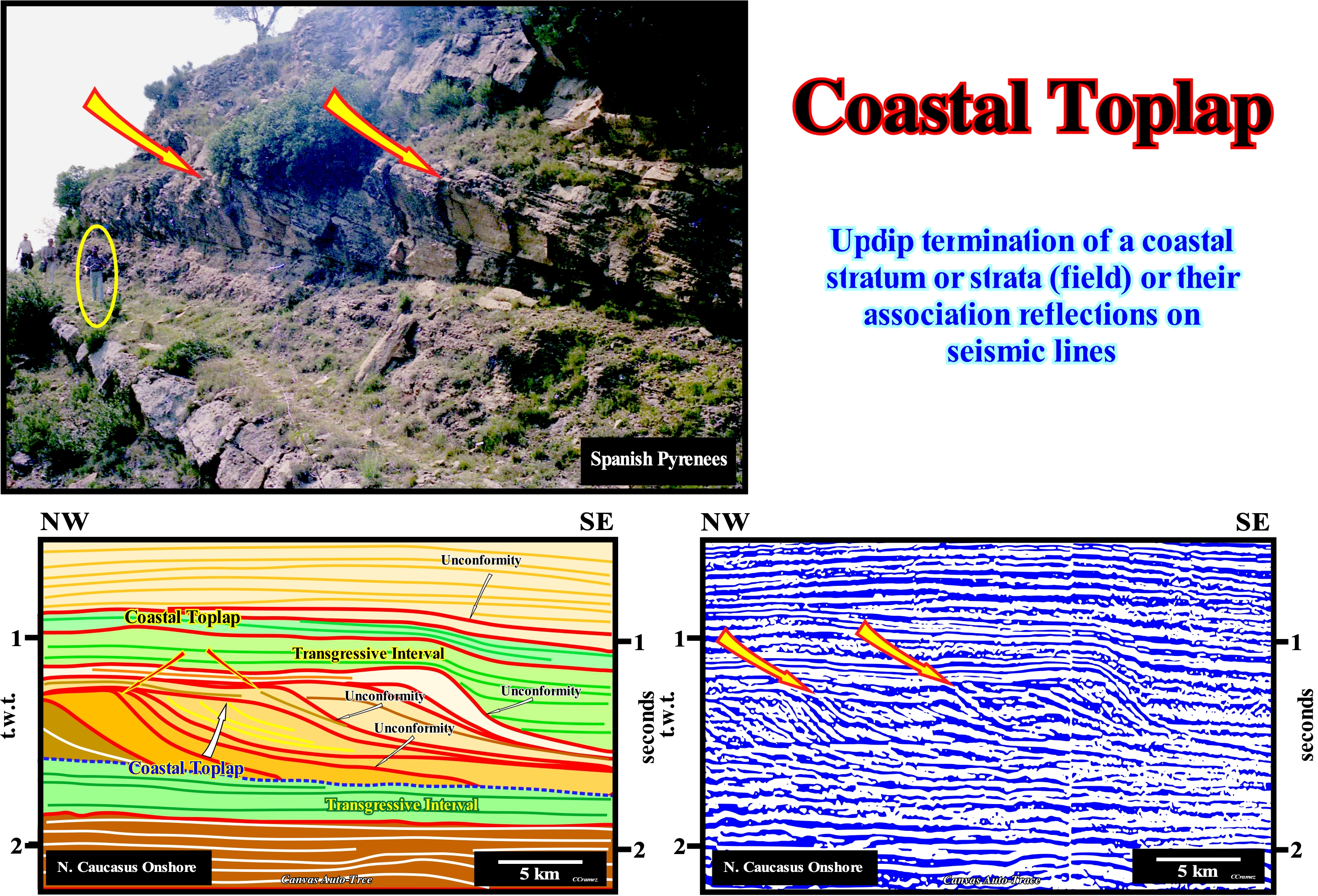
In the classification of the sedimentary basins of Bally and Snelson (1980), the northern Caucasus onshore corresponds to a folded mountain range. This folded mountain chain is the result of the collision between two divergent Atlantic-type margins. One is located northward of the Tethys Sea* and the other southward. Here, the term collision does not correspond to a transformation of kinetic energy into "deformation" energy, but to a simple resistance loss of the sediments to deformation. On this tentative geological interpretation of a Canvas auto-trace of a detail of a seismic line of North Caucasus onshore, the coastal toplaps are associated with regressive sedimentary intervals and, most of them, fossilized by the unconformities (erosional surfaces) limiting the different stratigraphic cycles (probably sequence-cycles). When the age difference between the unconformities bounding a seismic interval is greater than 3-5 My and less than 50 million years, the interval is considered to be a continental encroachment subcycle. If the age difference of the discordances ranges between 0.5 My and 3-5 My, the sedimentary interval is considered to be a sequence-cycle, induced by a 3rd order eustatic cycle. A sequence-cycle is composed by a stacking, more or less, vertical of sedimentary systems tracts, which can be are arranged into two groups. The sedimentary systems tracts of the lower group deposit in lowstand geological conditions (sea level lower than the basin edge), while the systems tracts of the second group are deposited in highstand geological conditions. Above the lower transgressive interval (coloured in green), which is characterized by a retrogradational geometry (poorly visible on this tentative due to the small longitudinal extension of the auto-trace) and by a parallel internal configuration. The progradational geometry of the overlapping regressive intervals is evident. Each regressive interval corresponds, probably, to an incomplete sequence-cyle (in which certain sedimentary systems tracts sub-groups have not been deposited). Within the regressive intervals, limited between two transgressive intervals (coloured in green), the internal configuration is either oblique or sigmoid. When the internal configuration is oblique (with little or no visible aggradation), more likely, the toplaps are associated with a non-depositional area. However, it can not be excluded that they have been formed by erosion. Conversely, when the internal configuration is sigmoid, i.e., when the aggradation (upbuilding or vertical deposition) is seismically recognized, most likely the toplaps mark the depositional coastal break of the different chronostratigraphic lines or they underline a facies change (sometimes, also, a sedimentary environment change). Under these conditions, it is possible that a small relative sea level fall occurred, but it was, certainly, not enough to change the highstand geological conditions into lowstand, i.e, to meagre to bring the sea level lower than the basin edge. On the auto-trace of a detail of an Australia offshore seismic line, a regressive interval and coastal toplaps are, easily, recognized. The deposition of successive regressive intervals (practically without aggradation between) fossilized an old continental shelf (underlying transgressive interval). At the hierarchic level of the sequence-cycles, from a given moment the shoreline coincided, more or less, with the continental edge, which allows to say, at least seismically, that since then the basin has no shelf (since a new continental edge is coincident with the shoreline).
(*) The Tethys Sea separated the Gondwana and Laurasia small supercontinents , when the Pangea supercontinent brokeup. This sea has nothing to do with the Paleo-Tethys Sea which is the Paleozoic sea situated between the small Gondwana and Euramerica supercontinents, which began to form in Late Ordovician, about 450 Ma, replacing the ancient ocean Proto-Tethys and which disappeared at the end of the Triassic about 200 million years ago, being replaced by the Tethys Sea.
(**) At the level of a sequence-cycle, the continental edge individualizes since a continental shelf is formed, i.e., since the transgressive interval (TI) begins to deposit. During the highstand systems tracts group (HSTG), the basin edge is the continental edge. The lowstand deposits fossilize the continental slope of the preceding sequence-cycle and, therefore, they can only define a continental edge when a platform forms over them. During the deposition of lowstand systems tracts, as the basin has no shelf, the basin edge is the last continental edge of the previous sequence-cycle.
Coastline (Shoreline).............................................................................................................................................................................................Ligne de côte
Linha da costa / Línea de costa / Küstelinie / 海岸线 / Береговая линия / Costa, Litorale /
Line separating land from sea. The position of the coastline is function of relative sea level changes. The shoreline or coastline, as certain geoscientists say, is the boundary between land and sea that is constantly subject to changes caused by the action of the waves, coastal currents, tides and relative sea level changes. Movements of the crust (subsidence or uplift) induce the formation of (i) Emersion or regression coasts (uplift) and (ii) Immersion or ingression coasts (subsidence).
See: « Shoreface »
&
« Coastal Plain »
&
« Coastal Plain Edge »
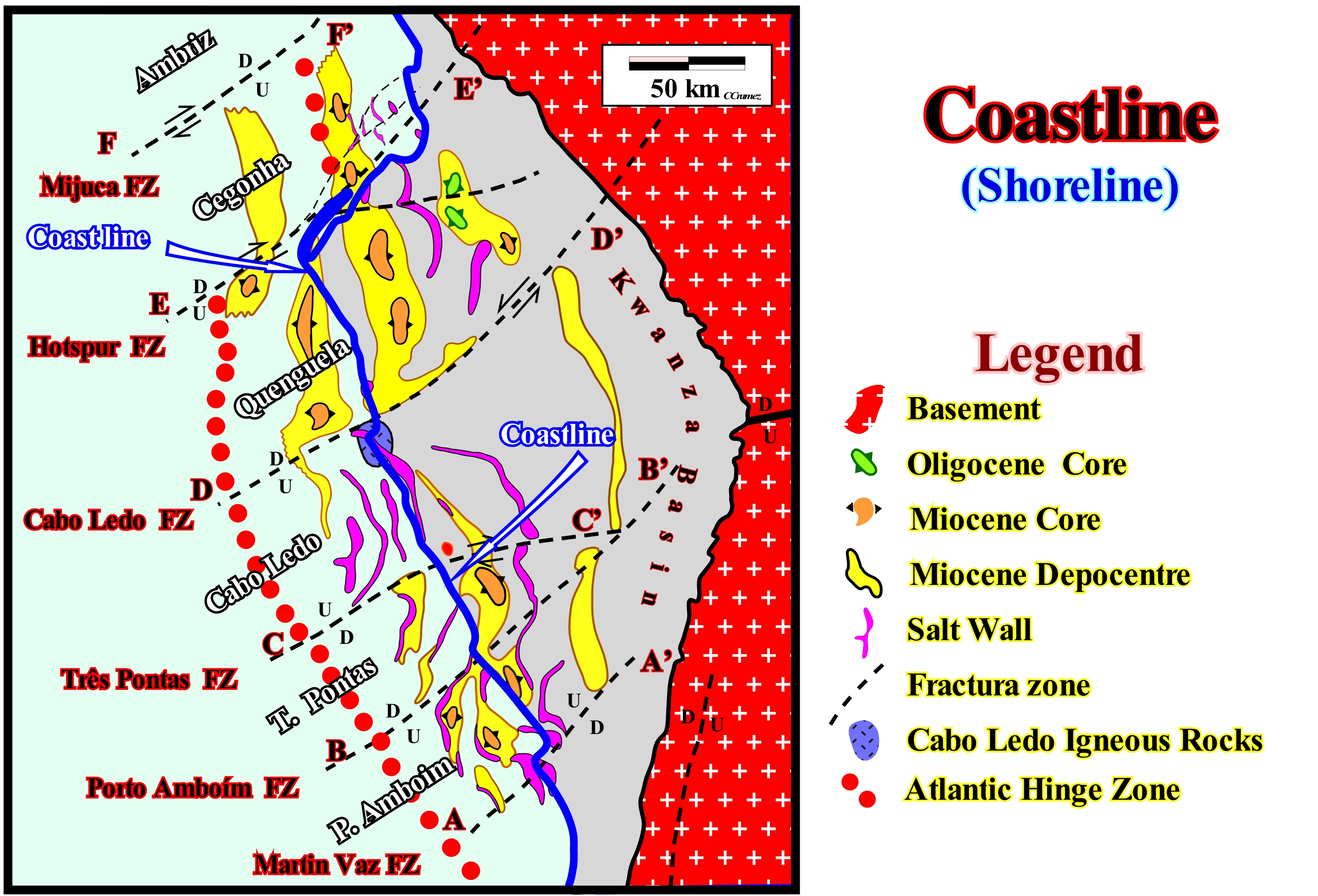
When the relative sea level rises (sea level referenced to the base of sediment or to the sea floor), by the combined action of eustasy (global sea level, referenced to a fixed point, which, generally, is the Earth's centre) and tectonics (subsidence or uplift of the sea floor), the coastline moves to the mainland (marine ingression) and on the preexisting topographic surface, under the action of waves, is formed a ravinment surface. A relative sea level rise (marine ingression) is done in steps (increments), separated by stability periods of relative sea level during which deposition occurs. Each step or each increment of relative sea level rise corresponds to an eustatic paracycle and the sediments deposited during the associated stability periods of the relative sea level are the sequence-paracycles that emphasize sedimentary regressions. As the relative sea level rises in acceleration (increasingly important marine ingressions and increasingly smaller sedimentary regressions), the coastline, globally, shifts landward forming the transgressions of Cesare Emiliani (1992). However, in areas with large terrigeneous influx, such as in certain delta areas, even when the relative sea level rises, in acceleration, the coastline and the associated deposits can rest in the same place, or even move seaward. Within a sequence-cycle, when the relative sea level rises in deceleration (in several steps), globally, the coastline and the coastal deposits move seaward (sedimentary regressions). When, globally, the coast line moves continentward, geoscientists speak of sedimentary transgressions (increasingly important marine ingressions and increasingly smaller sedimentary regressions). When, globally, the coastline moves seaward, they speak of sedimentary regressions (increasingly smaller marine ingressions and increasingly important sedimentary regressions). However, at the hierarchical level of sequence-cycles, do not forget three important things: (i) In both cases, i.e., during sedimentary transgressions or sedimentary regressions, the relative sea level rises (during sedimentary transgressions it rises in acceleration and, in deceleration, during sedimentary regressions) ; (ii) In order to have deposition up-dip of the basin edge (whether or not the basin has a shelf), it must, always, occur an increase in shelfal accommodation, i.e., an increase in the available space for the sediments ; (iii) The terrigeneous influx, as its name implies, always comes from the continent. Collectively, sedimentary transgressions are a succession of increasingly smaller sedimentary regressions, among which the relative level of the sea rises in acceleration (ingression or eustatic paracycle). During sedimentary transgressions, the coastline does not coincide with the basin edge, even if before (lowstand prograding wedge deposition), the coastline and the basin edge were, more or less, coincident. At each increment of relative sea level rise (eustatic paracycle), the extension of the shelf increases (distance between the basin edge, which is more or less fixed, and the coastline). At the beginning of a sedimentary regression, the coastline is at the maximum distance from the basin edge. However, as the sedimentary regression progresses, the shoreline approaches the basin edge and the extent of the shelf decreases. After a certain moment, the basin no longer has a shelf, and since then the coastline coincides with the basin edge, which corresponds to the continental edge. Although the position of the coastline is controlled by relative sea level changes, as illustrated in this map (Kwanza Basin, Angola), tectonics plays an important role. In this area, the coastline, which, overall, has a NO-SE orientation (in blue) is several times shifted eastward by the movement along the fracture zones (extensional movement), which divide the Kwanza geographic basin* and, mainly, the onshore, in different tectonic provinces. Each of these provinces has characteristics petroleum systems (genetic relation between a source-rock and an oil pool, characterized by a trap, a rock-reservoir and a sealing-rock).
(*) The Kwanza geographic basin corresponds to a stacking of sedimentary basins that in the classification of Bally and Snelson (1980), from the bottom to top, are: (i) A more or less flattened Paleozoic Fold Belt ; (ii) Late Jurassic / Late Cretaceous / Late Cretaceous rift-type basins and (iii) A Mesozoic / Cenozoic Atlantic divergent margin.
Cobble..................................................................................................................................................................................................................................................................Galet
Calhau / Guija, Guijarro / Kiesel - Stein / 凑齐 / Валун, галька / Ciottolo /
Rock or rock fragment with a diameter ranging from 64 to 256 mm or with a φ {φ = -log2 (diameter in mm) between -6 and -8 on the Krumbein scale (phi).
See: « Granulometry »
&
« Gravel »
&
« Sand »
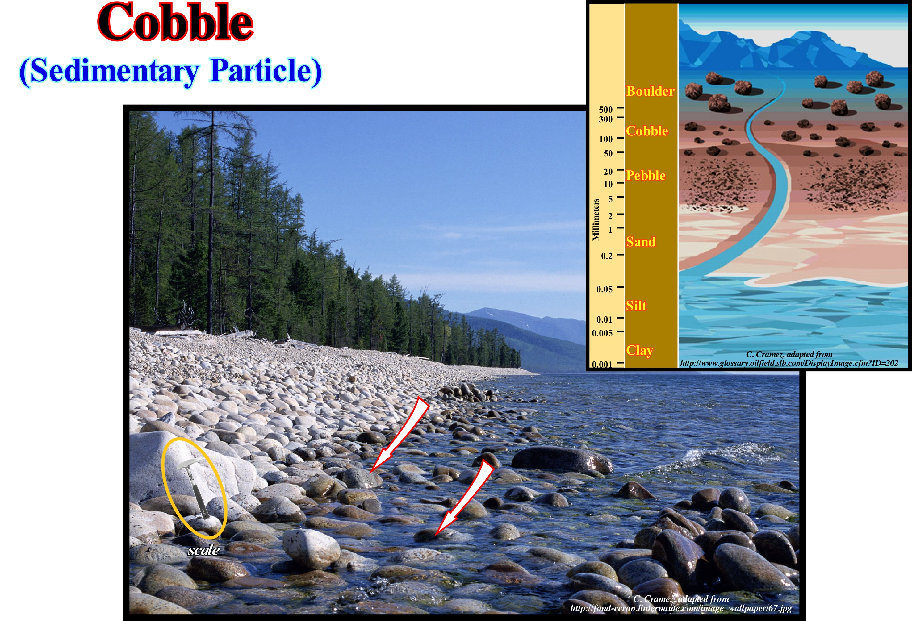
In this photograph, the cobbles of a beach are washed by the uprush and backwash currents. Krumbein's phi (φ) scale, which is a modification of the Wentworth scale, is a logarithmic scale computed by the equation φ = - Log2 D/D0. In this equation, φ is the Krumbein phi scale, D the diameter of a particle,D0 is the reference diameter, equal to 1 mm to make the equation consistent from the point of view of the dimensions. Using φ, the equation φ = - Log2 D/D0 can be transformed into: D = D0 x 2-φ. In the Krumbein classification: (i) When φ is less than -8 (greater than 256 mm) the particle is called a Block or Boulder ; (ii) When φ is between -6 and -8 (diameter between 64 and 256 mm) it is a Cobble ; (iii) When φ is between -5 and -6 (32 and 64 mm), the particle is also called Pebble ; (iv) When φ is between -4 and -5 (16-32 mm) it is Gravel Gravel; (v) φ between -3 and -4 (8-16 mm) is Medium Gravel; φ between -2 and -3 (4 and 8 mm) is Fine Gravel; (vi) When φ is between -1 and -2 (2 and 4 mm) it is very fine gravel; (vii) When φ is between 0 and -1 (1 and 2 mm) it is Very Thick Sand; (viii) When φ is between 1 and 0 (0.5 and 1 mm) it is Thick Sand; (ix) When φ between 2 and 1 (0.25-0.5 mm) it is Medium Sand; (x) φ between 3 and 2 (125 - 250 μm) are Fine Sand; φ between 4 and -3 (62.5-125 μm) is very fine sand; (xi) When φ is between 8 and 4 (3.9 and 62.5 μm) it is a silt; (xii) When φ is greater than 8 (diameter less than 3.9 μm) it is a Clay; (xiii) When φ is less than 10 (1 μm) it is a Colloid. The USCS (Unified Soil Classification System) classification, used to describe soil texture and granulometry, is simpler: (a) Ballast, when more than 50% of the particles are retained in a 4.75 mm mesh net; (b) Sand, when 50% of the particles are retained in a 4.75 mm mesh net; (c) Silt and Clay, when more than 50% of the particles pass through a 0.075 mm net. In this classification the letters G ("gravel") for ballast are used; S ("sand") for sand; M ("mud") for lime; C ("clay") for clay and O ("organic") for colloid.
Cobble (Pebble)......................................................................................................................................................................................................................Galet -Bloc
Calhau (cascalho) / Grava gruesa / Kiesel - Stein / 凑齐 / Булыжник (галечник) / Ciottolo /
Particle or fragment of a rock with a diameter around 265 mm, especially when it is rounded (between a cobble and a boulder).
See: « Clay »
&
« Granulometry »
&
« Cobble »
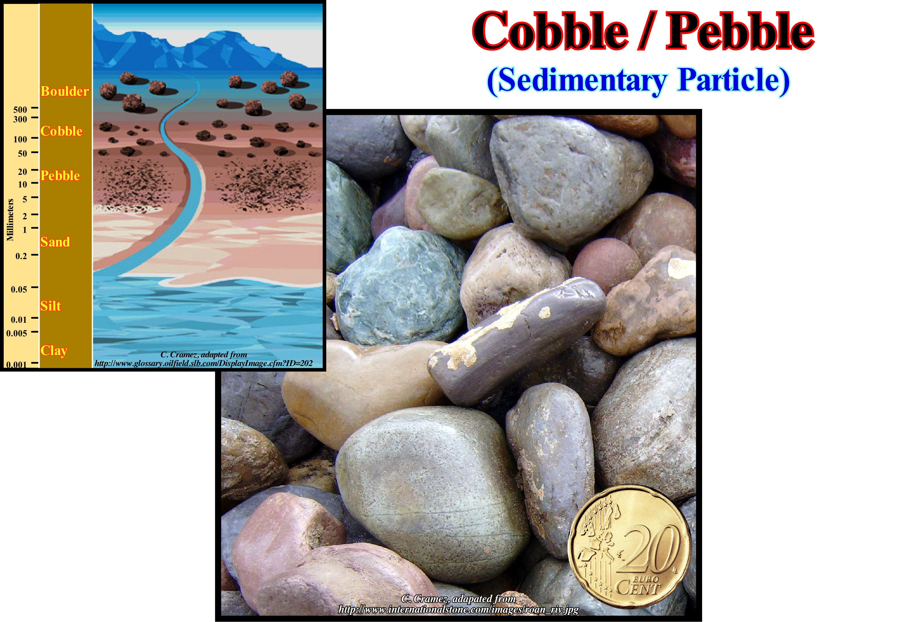
The sedimentary particles or debris de rocks with a granulometry lower that a pebble are : (I) Gravel, i.e. any debris of unconsolidated or consolidated rock, whose particles are larger than 2 mm and smaller than 64 mm, and (ii) Sand whose grains range between 0.0625 and 2 mm. Some geoscientists divide the gravel into thick gravel (grains larger 2-4 mm) and small gravel when the grain size varies between 4 and 64 mm. According to some standards, such as those of the Brazilian Association of Technical Standards, a "Boulder" is a soil composed of mineral or rock particles with a diameter between 2.0 and 60 mm, which when rounded or semi-rounded are referred to as pebbles or gravel, which means that the terminology and boundaries between individual particles vary according to geoscientists. The most widely used granulometric grades are those of Atterberg and Wentworth. The divisions in the Atterberg scale are: (i) Block / Pebble (diameter between 20 mm and 200); (ii) Gravel (diameter between 2 and 20 mm); (iii) Thick Sand (diameter between 2 and 0.2 mm); (iv) Fine sand (diameter between 0.2 and 0.02 mm); (v) Silt (diameter between 0.02 and 0.002 mm) and (vi) Clay (diameter <0.002 mm). In the Wentworth scale, there are four main divisions: (a) Ballast (diameter greater than 2 mm); (b) Sand (diameter between 2 and 0.062 mm); (c) Silt (diameter between 0.062 and 0.003 mm) and (d) Clay (diameter <0.001 mm). On the Wentworth scale, Silt is divided into: (1) Coarse silt; (2) Medium silt ; (3) Fine silt and (4) Very fine silt. In the same way, the sand is divided into: (i) Very coarse sand; (ii) Coarse sand ; (iii) Medium Sand; (iv) Fine Sand ; (v) Very Fine Sand. Four subdivisions are also included in the ballast: (A) Block (diameter> 200 mm); (B) Pebble (diameter between 50 and 200 mm); (C) Gravel (diameter between 50 mm and 4) and (D) Sand (diameter 4 mm and 2). To avoid misunderstandings, when grain size is used in a given study, it is always better to schematize the scale and terminology. On the other hand, it is always good to say when we a talking about a rock or about a particle. A conglomerate, a breccia or a rudite are sedimentary rocks constituted by a gravel formed by blocks, cobbles, pebbles or gravel. In the same way, a sandstone or an arenite are sedimentary rocks formed by sand-like particles, whereas a siltite and a shale are sedimentary rocks constituted by sedimentary particles of mud- type composed, respectively, by silt and clay.
Coccolith.......................................................................................................................................................................................................................................Coccolithe
Cocólito / Cocolito / Coccolith / 颗石藻 / Кокколит / Coccoliti /
Calcium carbonate plates formed by simple alga, such as "Emiliana huxlei" (coccoliphores) that are arranged around it in coccospheres*. Coccoliths are formed inside the cell in vesicles from the body or Golgi apparatus (organelle found in many eukaryotic cells). When the coccolith is complete, the vesicles fuse with the cell wall and the coccolith is incorporated into the coccosphere.
See: « Algae »
&
« Calcrete »
&
« Fossil »
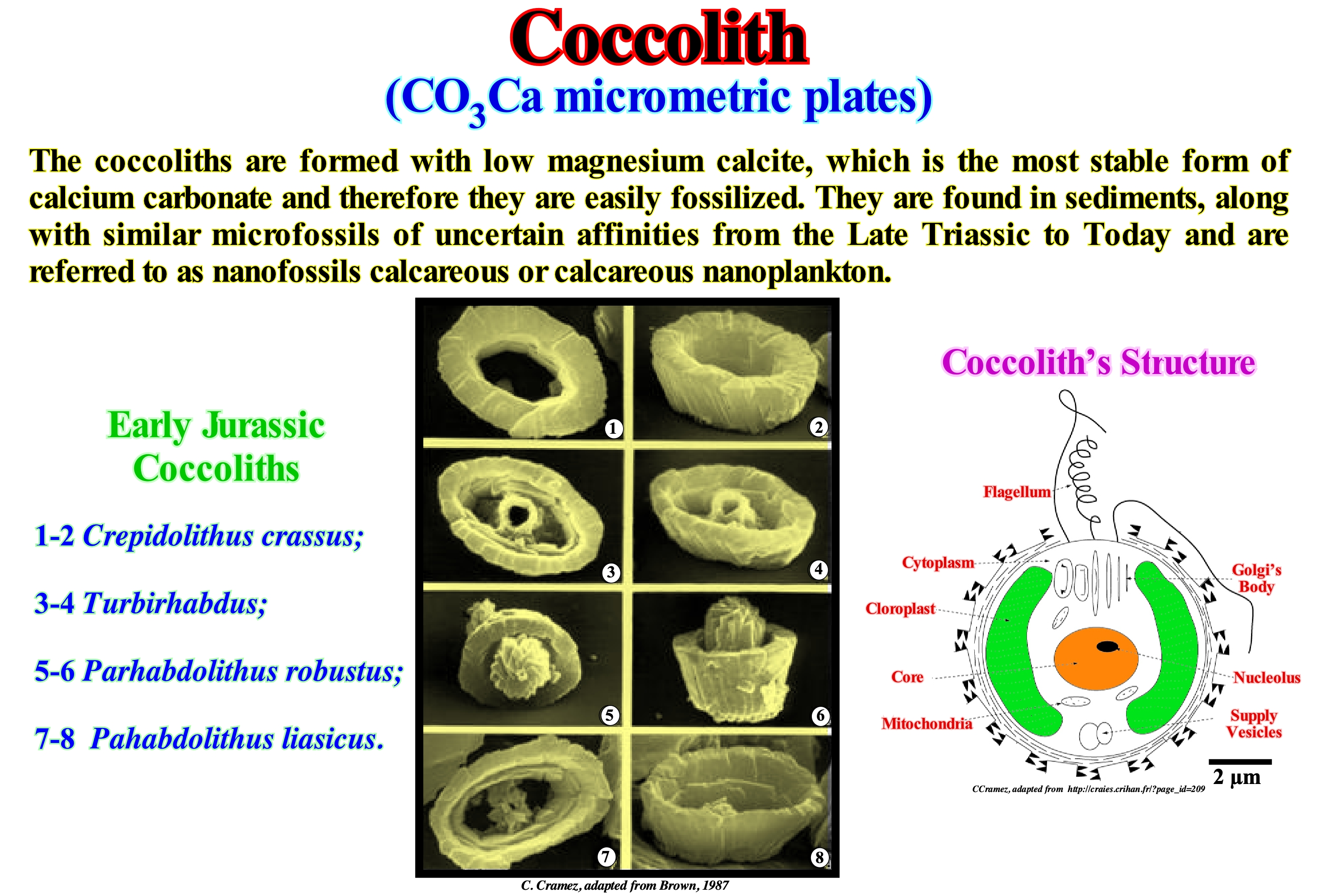
Thomas Huxley was the first geoscientist to observe the coccoliths in modern marine sediments. It was Huxley who named them this way. Coccoliths are formed within the cell in vesicles derived from the Golgi's apparatus (or body), which is part of the cellular endomembrane system (membranes that divide, internally, the eukaryotic cells) and whose main function is to process and pack macro-molecules, such as proteins** and lipids***, after their synthesis. When the construction of a coccolith ends the vesicles fuse with the cell wall and the coccolith is incorporated into the coccosphere. After the death of the coccosphere, the coccoliths are split and dispersed. The coccoliths sink through the water-column to form an important part of the deep-water sediment. There are two main types of coccoliths: (i) Heterococcoliths and (ii) Holococcoliths. The former are formed of a radial matrix of crystalline units. Holococcoliths are formed by small rhombohedrons of calcite (about 0.1 micrometers) arranged linearly. Initially, it was thought that these two types of coccoliths were produced by different families of coccolithophores (organisms that have coccoliths). Today, it is thought, that they are produced by the same species, but at different stages of the life cycle. Heterococcoliths are produced in the diploid life cycle phase (when chromosomes are present in pairs) and holococcoliths in the haploid phase (when chromosomes are present in a single specimen). Because the coccoliths are formed from calcite with a low Mg content (the most stable form of calcium carbonate), they are easily fossilized. They are found in sediments with micro-fossils of similar uncertain affinities from the Triassic to the Recent. Coccoliths and related fossils are referred to as calcareous nano-fossils or calcareous nano-plankton.
(*) External skeleton of the Haptophytes that are marine unicellular algae characterized by having two flagella, a contractile appendix and bare cells or covered with carbonate plates or scales (coccoliths) which contribute, significantly, to the oceanic sedimentation.
(**) Large biomolecules or macromolecules consisting of one or more long chains of amino acid residues.
(***) Bio-molecules that are soluble in nonpolar solvents ( hydrocarbons used to dissolve other naturally occurring hydrocarbon lipid molecules that do not dissolve in water). Lipids store energy, signalling and acting as structural components of cell membranes.
Coevolution......................................................................................................................................................................................................................Coévolution
Coevolução/ Coevolución / Koevolution / 协同进化 / Коэволюция / Coevoluzione /
Change of a biological object caused by the change of a related object. Process where the simultaneous evolution of two or more species that have a close ecological relationship takes place. In biology, coevolution can occur at various levels. It may be microscopic (for instance, mutations between amino acids of a protein) or macroscopic, as the covariant characteristics between different species within a given environment.
See: « Theory of Evolution »
&
« Sedimentary Environment »
&
« Animal Kingdom »

The image illustrated in this figure suggests how two species, in this case a fly and an orchid, can influence the evolution of each of them. But the story says may not be what you think. Coevolution, as this process is now called, was one of Darwin's most important ideas. Scientists today recognize coevolution in almost all types of species from ants to microbes in our own gut. Darwin conjectured coevolution by observing the bugs and flowers in the vicinity of his own residence in England. Darwin's conjectures about coevolution began with a simple question: How do flowers have sex? Typically, in a flower both sex organs exist, but Darwin doubted that a single flower could fertilize itself often. Flowers, like other organisms, show variations. Darwin advanced the only way the flowers had to vary was if each couple fertilized themselves to blend their characteristics (sex seems to be non-essential for creating variations, but does a good job in that regard). To fertilize, plants can not move to find partners. Thus, pollen has to go from one flower to another, which must happen at least in a member of its own species. The wind may be sufficient for some plants. Darwin knew, for example, that bees visit many flowers to collect the nectar. He observed how the bees landed on the petals of certain plants to reach their nectar, and found, the precise place to brush the pollen to the back of the bees, then travel to other plants of the same type where they discharge the pollen they carry. Thus, it can be said bees rely on flowers to feed themselves and that flowers depend on bees for sexuality. Without others, they could not survive. Coevolution is fundamental to the survival of many species.
Colluvium......................................................................................................................................................................................................................................Colluvion
Coluvião / Colluvium / Kolluvium / 崩积层 / Коллювий / Colluviale /
Inconsistent sedimentary body deposited or accumulated at the base of a hillside or against a barrier in a slope, whose sedimentary particles were transported by gravity (without the action of water). Often, colluviums are interconnected with alluviums (deposits transported by descending water).
See: « Alluvium »
&
« Alluvial »
&
« Alluvial Delta »
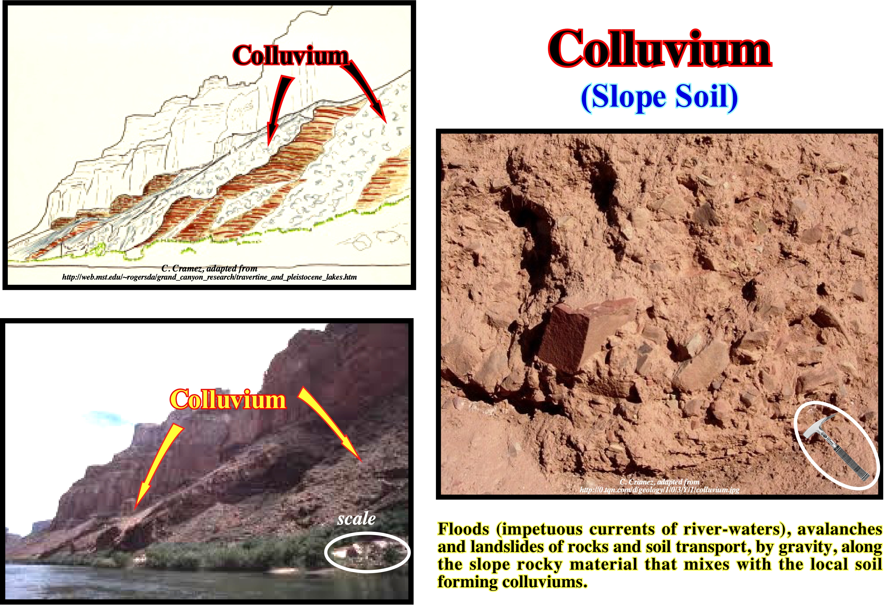
A colluvium is a set of sediments that travels down the coast to the base of a slope without the help of streams. Gravity in the form of sliding (slow process associated with humidification / drying or freezing / thawing cycles, whose evidence is sometimes marked by the inclination of trees and telephone poles) and laminar runoff* during heavy rains are the predominant agents. The process of accumulating a colluvium is colluvionation, which produces undifferentiated sediments of all sizes, but, relatively, little abraded by abrasion: the particles are angular. Avalanches and landslides are the most frequent processes in the formation of a colluvium. A coarse colluvium located at the base of a cliff is sometimes called a slope, which when lithified is called the slope-breccia. As shown in this figure, colluviums, typically, form rounded protuberances at the base of the mountains or fan-like deposits that cover the ancient rock substrates. This sedimentary process is a very important phenomenon in archaeology and pedology. Many colluvial soils** tend to have an associated fragipan***, which, fundamentally, corresponds to a clay-rich subsoil horizon. One of the theories that tends to explain the formation of fragipan is the lubrication of the soil during a colluvium phase, in which the clay deposits seal the interface between the movable and stationary part of the soil along which the moving part slides. Ancient archaeological sites are, sometimes, preserved under colluviums, when later alterations of the terrain, such as deforestation, favour the sliding of the shoreline material.
(*) Geomorphological process in which a thin layer of mobile water flows to the surface of a slope and transports sediments.
(**) The soil is the set of more or less horizontal layers on the surface of the earth composed of mineral and organic matter that constitutes the support of terrestrial life and that functions as an interface between biosphere and lithosphere. The part of the soil, especially rich in organic matter, is called humus.
(***) Layers of altered underground soil that reduces water runoff and penetration into roots.
Column of Cave (Speleothem).............................................................................................................................................Colonne de grotte
Coluna de gruta / Columna de gruta (de caverna) / Column Höhle (Hölensinter) / 柱窟, 柱洞(石笋 ) / онна-сталактит (сталагмит) / Colonna di grotta (speleotema) /
Calcareous rock, more or less, cylindrical, resulting from the junction of a stalactite with a stalagmite.
See: « Sinkhole »
&
« Stalactite »
&
« Dissolution »
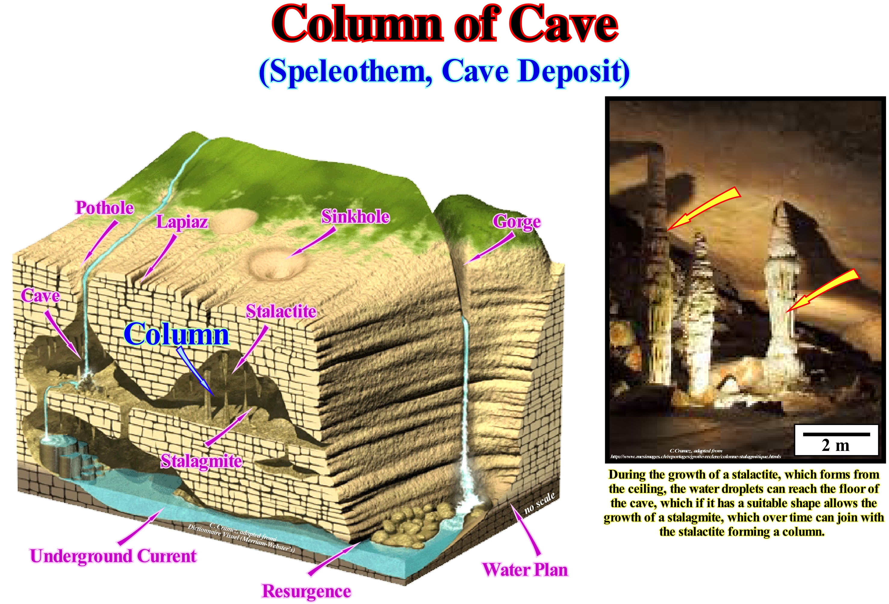
The columns of a cave are formed by the union of stalagmites* and stalactites **. Caves are formed by the action of acids on limestone or other rocks with a content of 80% or more of calcium carbonate (CO3Ca). Other conditions must be fulfilled. The rocks should be: (i) Highly fractured ; (ii) Near the surface ; (iii) Located in an area with abundant rainfall (more than 500 mm per year) and (iv) Covered by thick vegetation, which greatly increases the probability of acid production. Other factors, such as: (1) Moisture ; (2) Temperature and (3) Aeration of the basement favour the formation of speleothems (stalactites, stalagmites, columns, etc.). Associated caves and speleothems are formed when rainfall enters the fractures and cracks of rocks (usually, limestones or dolomites), since rainwater combined with carbon dioxide (CO2) forms an acid, although active carbon, called carbonic acid (H2CO3). This acid, once in contact with the limestone rocks, begins to dissolve the calcium carbonate, a process by which, progressively, the fractures and cracks widen. In addition, carbonic acid is, usually, enriched. It gets more active due to the absorption of carbon dioxide (CO2) from neighbouring plants and organic soils. The more limestone is dissolved, the sooner a network of tunnels and underground fractures forms, which form, gradually, a small cave with a whole array of associated geological bodies. The columns are formed after thousands, if not millions, of years of stalagmites and stalactites. Only when a stalagmite and a stalactite, finally, grow against each other does a cave column form. The formation of columns implies that there are no important environmental changes inside and outside the cave.
(*) Crystalline carbonate rock created by the evaporation of water droplets falling on the floor of a cave developed within a limestone geological formation.
(**) Crystalline carbonate rock created by the partial evaporation of water droplets falling from the ceiling of a cave inside a limestone formation. Unlike the stalagmites that grow from the floor of the grotto, the stalactites grow from the roof of the grotto.
(***) Carbonate formations produced by a slow precipitation of calcium carbonate (CO3 Ca). The term speleothem comes from the Greek "spelaion" (cave) and "thema" (deposit).
Commensalism........................................................................................................................................................................................Commensalisme
Comensalismo / Comensualismo / Kommensalismus / 栖 / Комменсализм / Commensalismo /
Biotic relationship between the two organisms, in which one benefits without the other being affected. There are three types of association between two organisms: (i) Mutualism (both organisms benefit) ; (ii) Competition (both organisms are harmed) and (iii) Parasitism (one organism benefits and the other is harmed).
See: « Biota »
&
« Theory of Evolution »
&
« Epifauna »

Commensalism is a relationship, between two species living together and in which one species benefits without harming the other, is much more difficult to demonstrate than mutualism*. In a true commensalism, one species must not be affected by the presence of the other. A detailed study of the relationship between the two species shows that the former always have a small effect on the latter. In the case of commensalism between barnacles (crustaceans that cling to scallops, rocks and ship's hooves) and scallops (bivalve molluscs of the pectinidae family - Penpecus maximus Lin.), Scallops may be affected by the presence of barnacles. Scallops feed, essentially, on the same planktonic plants and animals as barnacles. Therefore, there may be food competition between them. Moreover, it is difficult to prove that the weight of the barnacles on the scallop shells does not disturb the movements of the shells. On the other hand, the presence of barnacles on scallop shells can reduce predation** on scallops by marine gastropods (molluscs) that pierce the shells to reach the interior of the scallops. As illustrated in this figure, clown fish or anemone fish live between the anemone tentacles and are protected against potential predators that are not immunized with an anemone bite. These fish are protected against the bite of the tentacles of anemones by a substance contained in the mucosa of their skin. The exact nature of the protective substance is not known, but is probably a combination of a natural secretion of fish and chemicals acquired by friction against the tentacles of the anemones. Either way, anemones treat clown-fish as part of themselves and do not sting them. Some geoscientists consider this relationship is a typical case of mutualism, saying that clown-fish, in turn, chase away other fish that can attack anemones.
(*) Biological interaction between individuals of different species, where both benefit and improve their biological fitness.
(**) Type of interaction between living beings in which the predator feeds on prey.
Common Depth Method (Seismic).............................................................................................Méthode du CDM (Sismique)
Método do CDM / Método do CDM (sísmica) / CDM-Verfahren (Seismik) / 清洁发展机制方法(地震) / МОГТ (метод общей глубинной точки) / Metodo CDM (sismica) /
Displacement of the source and its trace of a certain distance below the line of fire, in order the reflections of the same layer are captured by the geophones in slightly different positions. Common depth method (CDM) improves the signal-to-noise ratio of a seismic shot. By repeating the shots and measuring them from slightly different positions along a linear transverse profile, the signals are recorded several times and can thus be added. This amplifies the signals and reduces, partially, the noise once the noise has no regular configuration along the line of fire. Then, all profile signals are grouped together, examined by computer and printed as a seismic profile.
See: « Reflection Seismic »
&
« Seismic Line »
&
« Seismic Reflection »
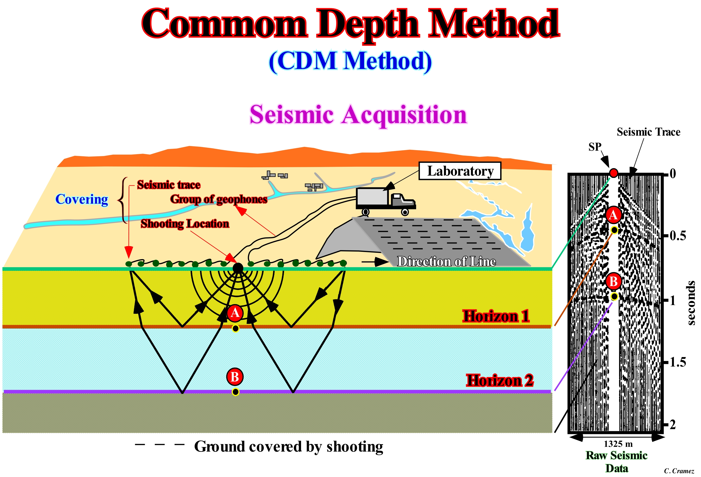
In simple terms, reflection seismic is the process of making a big bang and listening to the echoes. It is a process similar to the sonars of ships that picks up the echo to determine the depth of the sea floor. On land, the bang is, usually, produced by an explosion, usually, buried dynamite, but can also be produced mechanically (Vibroseis). In the sea, in general, the noise of the explosion of bubbles of gas under water is used. Sound waves travel in all directions, but only those that travel almost, directly, downward can be reflected by the interfaces underneath the explosion. The acquisition and treatment of seismic data goes through several stages. This diagram illustrates the acquisition. The source* (emitter) creates a low-frequency signal (explosion) that is reflected by the sedimentary layers. A series of geophones** connected to the laboratory, placed on the surface of the ground, captures the reflected waves under different angles of the source. The source and geophones are then shifted to allow each geophone to pick up the reflections from various angles. The reflections are recorded on a magnetic stripe and the records affixed. A large part of the noise of the seismic traces*** is withdrawn by electronic treatment and the reflection signals are grouped at the common depth point. Indeed, through proper correction, the strokes can be added (stack), which increases reflected energy and reduces noise (anything other than desired signal, which includes disturbances in seismic data caused by any unwanted seismic energy, such as shot generation ground roll, surface waves, multiples, effects of weather and human activity, or random occurrences in the Earth). In multi-channel seismic acquisition where beds do not dip, the common reflection point at depth on a reflector, or the half-way point when a wave travels from a source to a reflector to a receiver. In the case of flat layers, the common depth point is vertically below th common mid-point. In the case of dipping beds, there is no common depth point shared by multiple sources and receivers, so dip moveout processing**** is necessary to reduce smearing or inappropriate mixing of the data. (https://www.glossary.oilfield.slb.com/en/Terms/c/common_depth_point.aspx)
(*) A device that provides energy for acquisition of seismic data, such as an air gun, explosive charge or vibrator (an adjustable mechanical source, mounted on large trucks, that delivers vibratory seismic energy to the Earth for acquisition of seismic data.
(**) Devices that have a box with a spring mounted on a magnetic coil so that when vibrating the box also vibrates.
(***) A seismic trace represents the response of the elastic wave-field to velocity and density contrasts across interfaces of layers of rock or sediments as energy travels from a source through the subsurface to a receiver or receiver array.
(****) Alteration of seismic data to suppress noise, enhance signal and migrate seismic events to the appropriate location in space. Processing steps, typically, include analysis of velocities and frequencies, static corrections, deconvolution, normal move-out, dip moveout, stacking, and migration, which can be performed before or after stacking. Seismic processing facilitates better interpretation because subsurface structures and reflection geometries are more apparent. https://www.glossary .oilfield.slb.com/Terms/p/processing.aspx)
Compacted Clay..................................................................................................................................................................................Argile compactée
Argilito compactado / Arcilla compactada / Verdichtete Ton / 压实粘土 / Уплотненная глина / Argilla compattata /
Claystone that lost a large part of the interstitial water due to the load of the overlying sediments. Its volume decreseas and the claystone becomes more consistent and dense, i.e., more compacted.
See: « Clay »
&
« Argillite »
&
« Compaction »
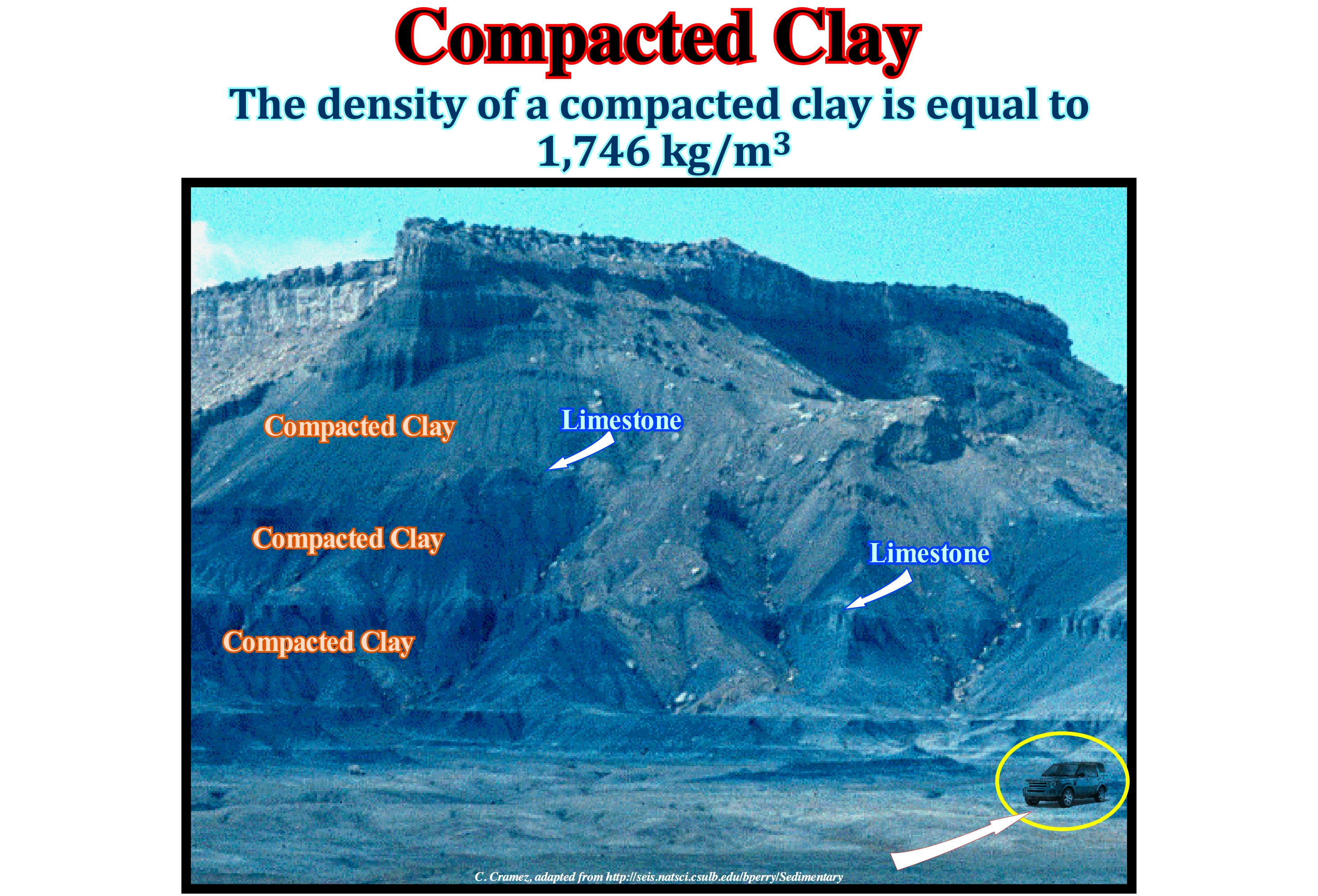
This mountain, in the State of Utah, is formed, mainly, of compacted clay, i.e., by the detrital (or clastic) sedimentary rock most commonly exposed at the Earth's surface. The clay (sedimentary particle) is, formed, from the residual and corroded grains of pre-existing rocks and deposited in layers in depositional areas such as valleys, lakes or marine basins. A clay becomes compacted due to precipitation on the surface of the grains, by loss of interstitial water, of authigenic minerals (minerals forming during sedimentation or early diagenesis), which form a natural cement. Compaction is a geological process in which a set of sediments loses their porosity (progressively) due to loading (weight of overlying sediments). Compaction is part of lithification*. When a layer of sediment is deposited, at first the space between the grains is filled with water. As more sediments deposit overhead, the loading increases the stresses between the particles which results in the reduction of primary porosity due to more efficient packaging of the particles, i.e., an increase in the elastic compression and dissolution of minerals in the contact between the grains (as, for instance, the formation of stylolites in the carbonates). The initial porosity (percentage of pore volume in relation to total volume) of the sediments depends on the lithology. The clayey rocks start having porosities higher than 60%, while the sandy rocks have about 40% and the carbonates, sometimes, more than 70%. However, with burial, as suggested by exploration oil wells, the porosity decreases sharply. When there is a significant lateral variation of the thickness and compactability of a sedimentary interval, the weight of the overlying sediments induces spatial variations of the compaction, which produces a variation of the thickness and structure in the overlapping interval, even in the absence of any tectonic activity, just due to differential compression of the lower interval.
(*) A set of geological processes (dehydration, compaction, cementation, recrystallizations, etc.) that convert the sediments i.e., rock particles or debris resulting from erosion, chemical precipitation from oceans, valleys or rivers, or biological deposition on the Earth's surface in layers of loose particles when it decreases the energy of the fluid (water, ice or wind) which carries it in consolidated rocks.
Compaction......................................................................................................................................................................................................................Compaction
Compactation / Compactación / Verdichtung / 压实 / Уплотнение (напр. горных пород) / Compattazione, Costipamento /
Volume or thickness reduction of sediments, usually, of fine grain, due to increased sediment load or tectonic pressures.
See: « Differential Compaction»
&
« Tectonic Subsidence »
&
« Porosity »
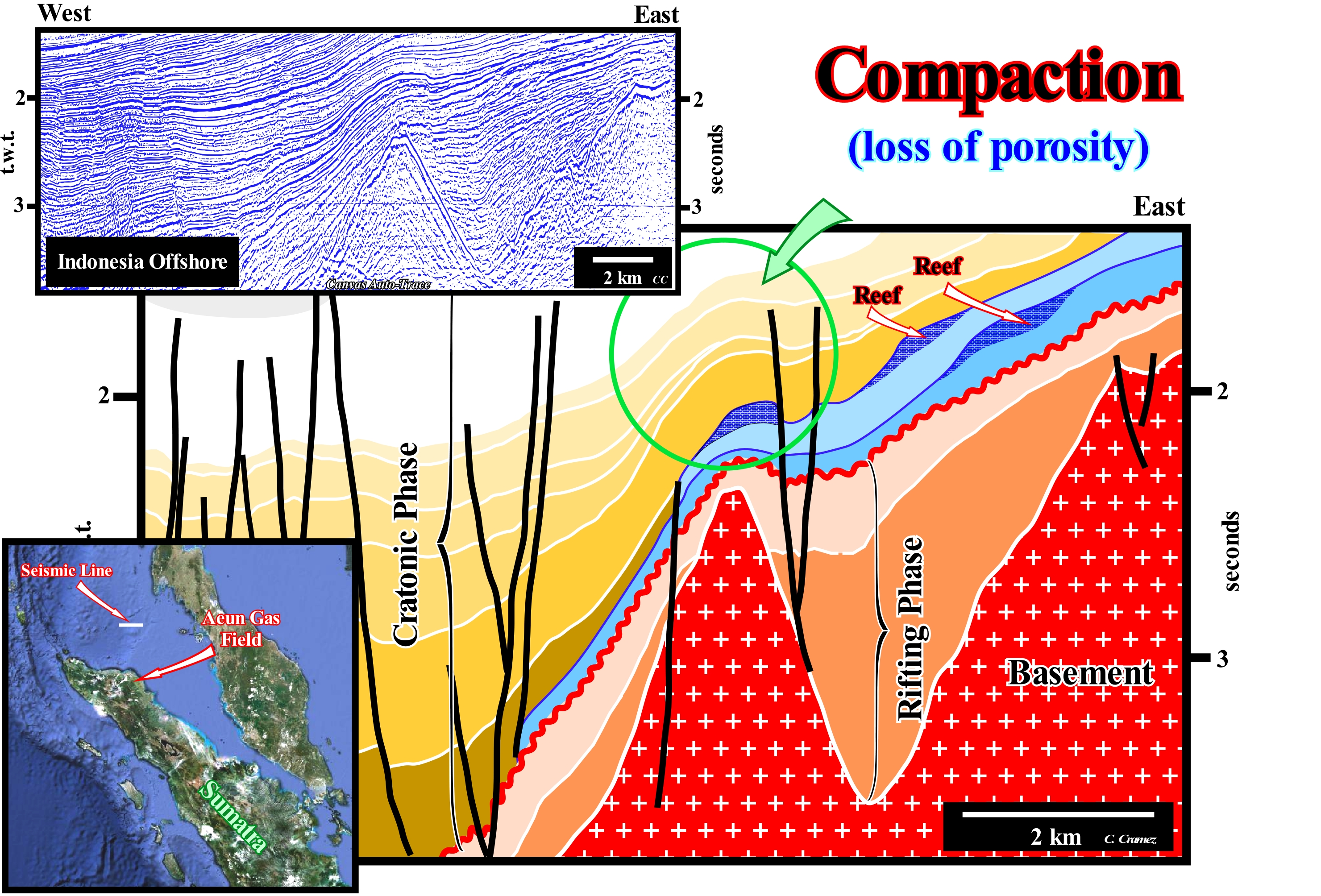
This figure illustrates a tentative of geological interpretation of a Canvas auto-trace of a offshore seismic line from eastern Sumatra Island, i.e., of a seismic line shot in a back-arch* sedimentary basin (inside the Sumatra volcanic arch), where a compressive tectonic regime shortened the sediments, mainly, by reactivation of the old normal faults, formed during the lengthening or rifting phase, as reverse faults. In this type of sedimentary basin, the continental crust behind the volcanic arch is, in a first stage, lengthened by normal faults in association with a differential subsidence (rifting or lengthening phase). The halfgrabens on the base of this tentative interpretation were formed during this tectonic phase. Later, in association with a thermal subsidence (cratonic phase), marine sediments were deposited. They contrasted with the non-marine nature of the sediments of the rifting phase. The thickness reduction of sediment intervals, deposited during the cratonic phase, above the high points of the basement (buried-hills), bordering the rift-type basins (halfgrabens), is the result of differential sedimentary compaction. Cratonic sediments are more compacted above the basement buried-hills than above the sediments of the rifting phase. The sedimentary compaction is, also, responsible for the deformation of the fault planes, i.e, by the changes of the dip of the fault planes. Initially, prior to compaction, the fault planes are, more or less, rectilinear. However, during compaction, the sedimentary intervals, which correspond here to an alternation of sandy and shale horizons, do not compact in the same way. The shale horizons are much more compacted (the initial thickness decreases much more), while the sandy horizons are, practically, not compacted (the initial thickness remains, more or less, constant during compaction). Thus, the dip of the fault planes within a sandy (less compactable interval) will be greater than within a shaly interval, since the initial thickness of this interval has been reduced.
(*) In the basin classification Bally and Snelson, one could consider the back-arc basins formed on an oceanic crust (marginal seas) and those resting on a continental or intermediate crust. As an example of the second type, we can mention the Sumatra back-arch basin, Brunei back-arch basin, and of the first type , the circumpacific back-arch basins.
Comparative Lowstand........................................................................................................Bas niveau comparatif (De la mer)
Nível baixo comparativo (do mar) / Nivel bajo comparativo (del mar) / Niedrige vergleichende Ebene (SEA) / 相对低水位(海)/ Сравнительно низкий уровень (моря) / Basso livello comparativo (mare) /
Expression used by certain geoscientists to designate a geological situation determined by a relative sea level fall which has brought the sea level lower than the depositional coastal break of the depositional surface (more or less the shoreline), but higher than the basin edge. During a comparative lowstand geological situation just a part of the shelf is exhumed, which is not the case during a lowstand situation, in which the entire shelf is exhumed.
See: « Sequence-Cycle »
&
« Lowstand (sea level) »
&
« Relative Sea level Change »
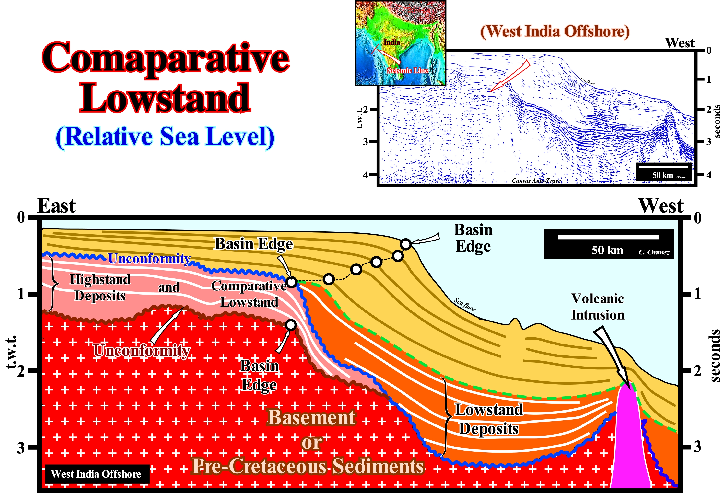
This tentative geological interpretation of a Canvas auto-trace of a regional seismic line of the West India offshore, is proposed at the hierarchical level of continental encroachment sub-cycles, i.e., the considered seismic intervals were, probably, induced by second order eustatic cycles, that is to say, eustatic cycles with a time-duration more than 3-5 My and less than 50 My. Theoretically and a priori, this offshore corresponds to a stacking of different basins of the classification of Bally and Snelson (1989). From bottom to top, on the lithosphere of the small Gondwana supercontinent, rift-type basins were deposited, during the lengthening of the lithosphere and before its break-up. Since the break-up of the lithosphere occurred, a divergent Atlantic-type margin was deposited. Its base is composed, mainly, of thick lava flows deposited in association with a sub-aerial volcanic spreading that preceded oceanic expansion or sea floor spreading. Within the divergent margin, two large sedimentary intervals can be highlighted: (i) A transgressive phase at the base, which is fossilized by (ii) A regressive phase. The transgressive phase has a retrogradational geometry (global continentward displacement of the shoreline and associated coastal deposits), which emphasizes a set of increasingly important marine ingressions and increasingly smaller sedimentary regressions. The regressive phase* has a progradational geometry (global seaward displacement of the shoreline and associated coastal deposits) which is the result of increasingly smaller ingressions and increasingly important sedimentary regressions. On this tentative interpretation, one can compare a stratigraphic interval, formed by rocks deposited under lowstand geological conditions (sea level lower than the basin edge), with an interval formed by rocks deposited at highstand geological conditions (sea level higher than the basin edge), but during which comparative lowstand periods are likely. It is important to note that the comparative lowstand conditions are in fact highstand, since the sea level is higher than the basin edge. In relation to the previous geological conditions, the sea level fell, but just a part of the shelf was exhumed (P. Vail type II unconformity). The unconformity underlined on this tentative, limits stratigraphic cycles that are not associated with 3rd order eustatic cycles, but with 2nd order cycles : (i) The age difference between the relative sea level falls that induced the two unconformities, is greater than 3-5 My ; (ii) The sedimentary intervals, as said above, correspond to continental encroachment sub-cycles and not to sequence-cycles ; (iii) The internal geometry of these sedimentary intervals is very different from that of the sequence-cycles, although each one consists of a stacking of a certain number of complete or incomplete sequence-cycles. The position of the basin edge at the level of the lower unconformity (coloured in brown) is, more or less, as indicated, which means that the overlapping interval is, basically, an interval that has been deposited during highstand geological conditions. The results of the exploration wells drilled in this offshore and the tentative geological interpretations of the detail seismic lines suggest the relative sea level fell, several times, exhuming part of the shelf (the resolution of the seismic lines is insufficient for recognize the different positions of the shoreline). On the contrary, the lower interval (in orange colour) the sediments overlying the upper unconformity (colored in blue) were always deposited in lowstand geological conditions. Keep in mind the seismic pitfall induced by the abrupt variation of the water-depth. The geometry of the reflectors on the right side of this tentative is apparent. In an depth version (in meters rather than seconds) the reflectors are much less dipping eastward. The deepest can even plunge westward.
(*) At this hierarchical level, marine ingressions are, above all, induced by rises of the absolute (eustatic) sea level, i.e., global sea level referenced to the Earth's centre and not of relative sea level (local sea referenced to the bottom of the sediments or to the sea floor), which is the result of the combined action of eustatic sea level and tectonics.
Compensation Current (Rip current)........................................................................................Courant d'arrachement
Corrente de compensação (corrente de compendação) / Corriente de desgarre (de las rompientes) / Ripströmen / 瑞普电流, 目前RIP / Сильное обратное течение / Corrente di ritorno, risacca /
Transverse or oblique current to the coastline flowing seaward (open sea). It affects surface and deep-water. Beyond the wave surf zone, in the direction of the open sea, it opens in fans, dividing into branches returning to the coast with the uprush current.
See: « Stream »
&
« Surge Current »
&
« Rip Current »
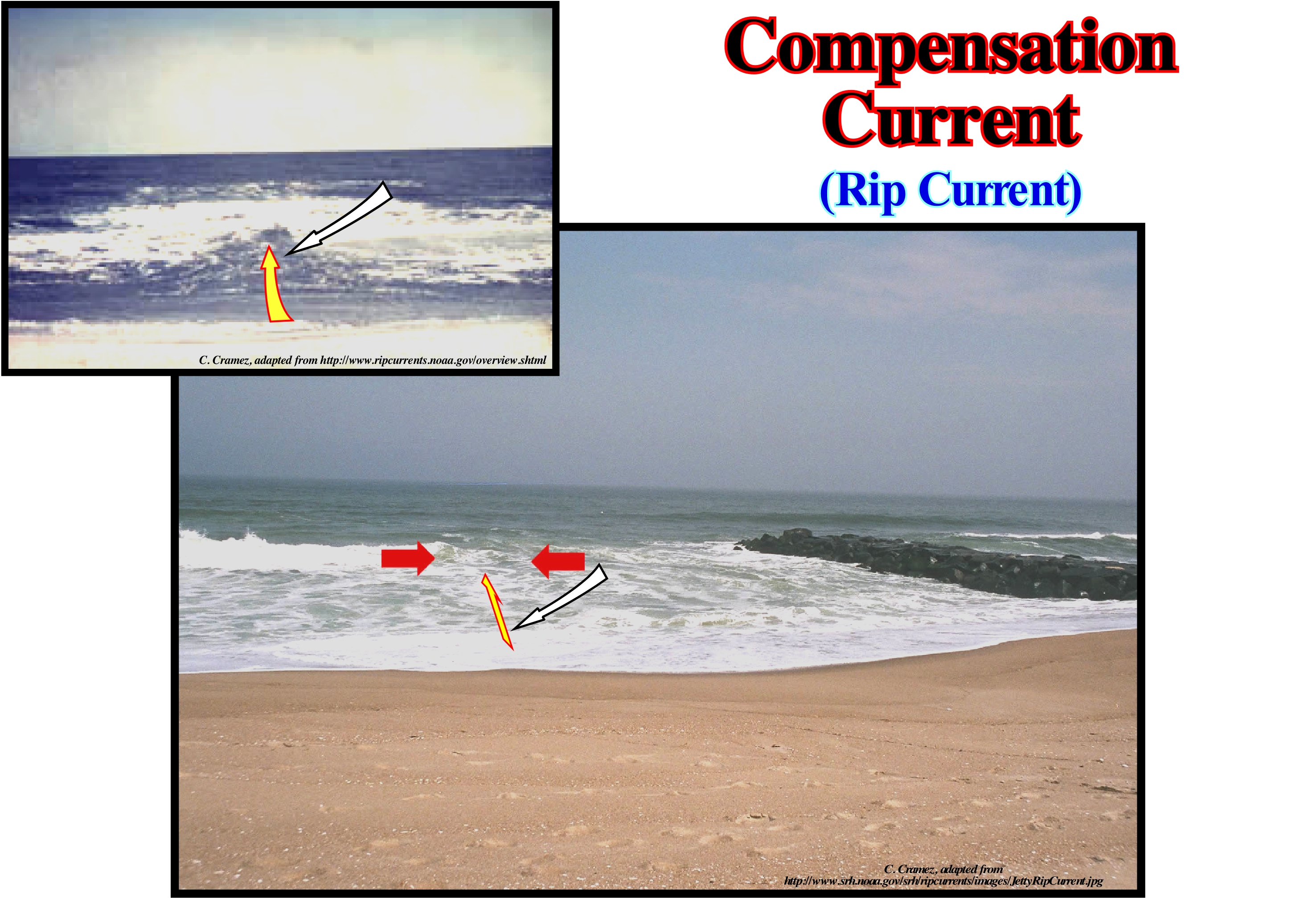
As the waves propagate from deep to shallow-waters, they break-up near the shoreline. When they are broken, strongly, in certain regions, and, sweetly, in others areas, circulation cells are formed as the compensating currents, which, as shown in this figure, are strong and narrow currents flowing seaward. These currents are dangerous for people who swim, badly, and, particularly, for those who can not swim. Although the velocity of a compensation current is, generally, relatively weak (± 30 to 50 cm/s). However, there are cases where they reach more than 3 m/s, i.e., a speed greater than that of an olympic swimmer. Compensating currents can, almost always, be found in the surf zone. Under normal sea conditions, and in most tides, the velocity of the compensating currents is relatively small. However, in special conditions of waves, tides and the slope of the beach, the speed of the compensation currents can increase rapidly, and in these conditions, they are very dangerous for anyone in the surf zone. The force and velocity of a compensation current increases with the height and period of the wave. This type of current is, easily, recognizable by: (i) A shaken water channel with a great deal of ripple ; (ii) A region where sea-water has a different colour ; (iii) A line of foam, algae or plant remains, moving, rapidly, seaward, and (iv) A break in the wave approaching the coast. If one day you get caught by this kind of current, keep calm to conserve energy and think clearly. Do not try to fight the current. Let it take you away from the shore line or swim sideways until you are out of its influence. Out of the flow, swim calmly toward the beach.
Compensation Depth (Carbonates)..................................................Profondeur de compensation (Carbonates)
Profundidade de compensação / Profundidad de compensación (carbonatos) / Carbonate Entschädigung Tiefe / 补偿深度 / Компенсационная глубина (карбонаты) / Profondità di compensazione (carbonati) /
Depth-water below which the calcium carbonate, produced in the ocean, is dissolved,completely. Depth-water below which there is no deposition of calcium carbonate.
See: « Deposition (carbonates) »
&
«Stratification (water) »
&
« Depositional Model (carbonates) »

Under the carbonate compensation depth (CCD), the rate of calcium carbonate (calcite and aragonite) and dissolution rate are compensated, i.e., no calcium carbonate is deposited. Calcium carbonate is, practically, insoluble in the superficial levels of sea-water. Calcareous plankton* shells falling into deep-water are, practically, intact until they reach lysocline (a term used in geology to indicate the depth of sea-water from which the rate of dissolution of calcite increases,dramatically). When they reach the depth of compensation of calcium carbonate, all of the calcium carbonate dissolves. Plankton and limestone sedimentary particles are just found in the water-column above the compensation depth. If the sea floor is above the compensation depth of the calcium carbonate (CCD), the sediments of the sea bottom may be limestone sediments. If the sea floor is lower than the depth of compensation, all limestones particles are dissolved before reaching the bottom. The solubility of calcium carbonate depends on the temperature, pressure, chemical composition of the water and the amount of carbon dioxide (CO2) dissolved in the water. Calcium carbonate dissolves more easily, at low temperature and high pressures. The sketch illustrated in this figure shows the morphology of the ocean floor and the mid-oceanic ridge, partially, control the nature of the sediments deposited there. When the oceanic crust is above the carbonate compensation depth (CCD), most of the deposited sedimentary particles are organic in nature (organic ooze). When the oceanic crust reaches greater depths, just terrestrial detrital sedimentary particles settle down on the ocean floor (fine levels of abyssal shales). As the oceanic crust cools, it becomes heavier and sinks more. This subsidence combined with eustasy (variations of absolute or eustatic sea level, which is supposed to be global, referenced to the Earth's centre) changes the available space for the sediments, which allows the deposition of the sedimentary wedge on the banks of the ocean basin, which, obviously, are postdate the rift-type basins formed and filled before break-up of the lithosphere of the associated supercontinent. A Mesozoic/Cenozoic sedimentary prism corresponds to the post-Pangea stratigraphic cycle of continental encroachment deposited in association with second 1st order Phanerozoic eustatic cycle. Such an eustatic cycle lasts over 50 million years and was induced by the volume variations of the ocean basins created by the dispersion (seafloor spreading) and agglutination of the continents (formation of a supercontinent), assuming that the amount of water, under all its forms, is constant since the Earth's formation (around 4.5 Ga). On this subject it can be read (https://www.ebah.com.br/content/ABAAAANHMAJ/a-analise-sedimentar-conhecimentos-dos-sistemas-marinhos?part=5): "There is a constant exchange of CO2 between the atmosphere and the hydrosphere. In regions rich in phytoplankton (wetlands) the excess CO2 is released into the atmosphere, while in arid zones CO2 is removed from the atmosphere by oceanic waters. Globally, and due, mainly, to biological activity, CO2 is removed from the ocean in the form of carbonates, which are incorporated into the marine sediments. The vertical zoning of carbonated pelagic sedimentation was observed for the first time during the Challenger expedition (1872 to 1876). Indeed, the solubility of CaCO3 increases with pressure (increasing depth) and decreasing temperature and salinity. Ocean water is, progressively, less saturated in carbonates as the depth increases. At depths of 2,000 to 4,000 meters the water is unsaturated. In the shallow part of the ocean, the saturation isolines are, directly, related to the hydro-chemical conditions and have, in general, winding tracing, which softens as the depth increases. In the Atlantic, the 100% saturation isolate is located at depths of the order of 4,000m (in the Pacific it is only 2,000m), becoming, progressively, shallow to north and south. Outside the carbonated sedimentation zone, that is, north and south of 60° latitude, the 100% saturation insulation in calcite reaches the surface. The differences between the oceans, with regard to carbonate sedimentation (and consequent dissolution of the particles), are related to characteristics of the circulation. In the northern hemisphere, where continents make circulation more complex, these differences are greater, being very small in the so-called austral ocean, where disturbances in circulation by the continental masses are minimal. "
(*) Plankton is composed of uni or pluricellular organisms, mostly microscopic, that float with little capacity for locomotion in the oceans and seas, on the surface of brackish waters, sweet or lakes. Some invertebrates, jellyfish and krill are examples of macroscopic plankton.
Compensation Point (Compensation depth, phytoplankton)..... ..Point de compensation (Phytoplancton)
Ponto de Compensação / Punto de compensación (fitoplancton) / Kompensation Punkt / 补偿点 / Компенсированная точка / Punto di compensazione /
Water-depth, in the ocean, where oxygen uptake and production compensates, i.e., the maximum depth at which phytoplankton (which produces oxygen) may exist. The compensation point corresponds, usually, to the base of the euphotic zone.
See: « Phytoplankton »
&
« Euphotic Zone »
&
« Photosynthesis »
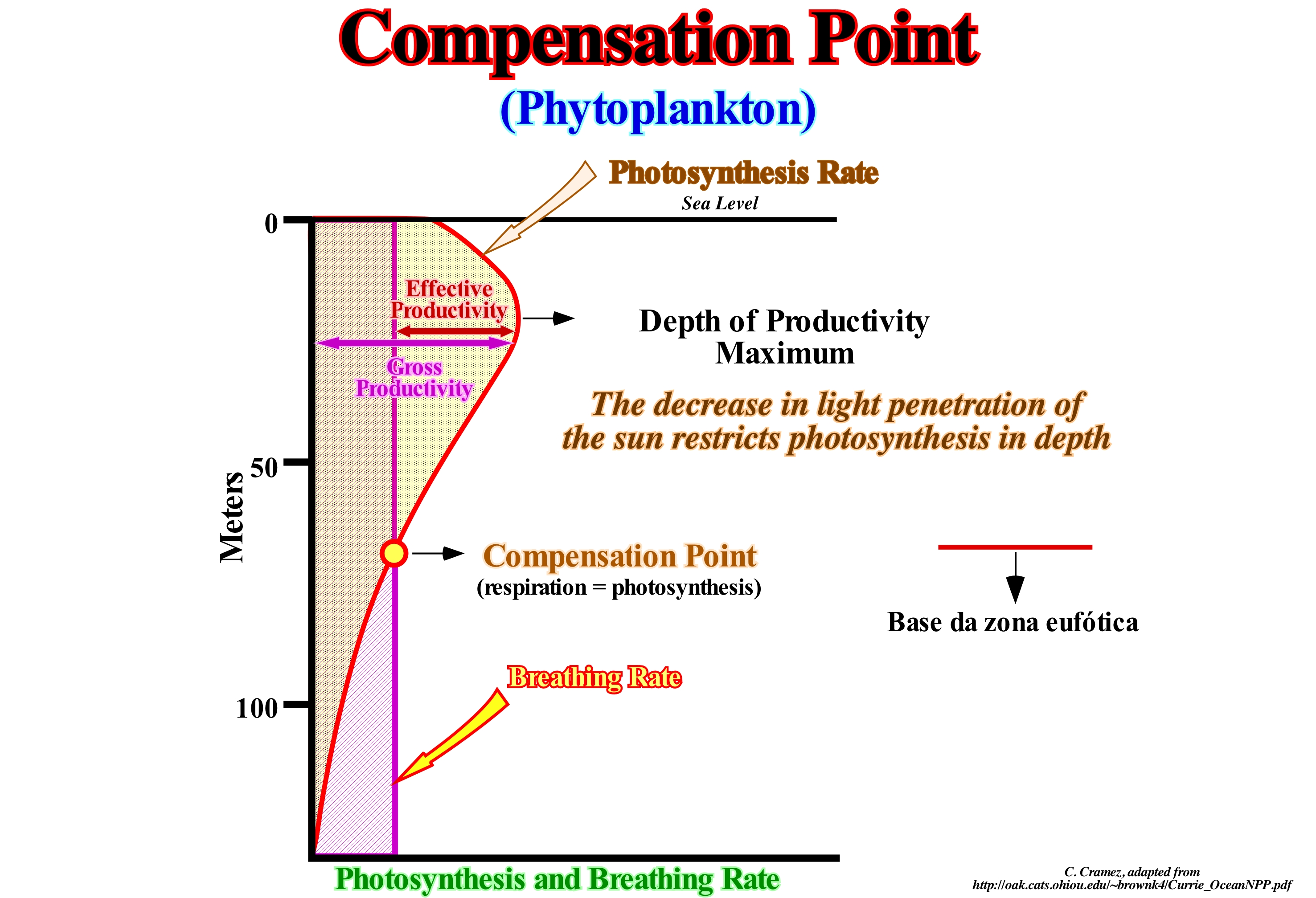
As shown in this figure, the compensation point, which depends on several factors, is the value of the light intensity in the light profile, in which the photosynthesis* rate matches, exactly, the respiration rate of the phytoplankton (autotrophic components of the plankton community and a key part of oceans, seas and freshwater basin ecosystems). At this point the absorption of CO2 via the photosynthetic processes is exactly equal to the release of carbon dioxide by respiration** and the absorption of O2 by respiration is exactly equal to the photosynthetic release of oxygen. In the process of photosynthesis, it is clear that carbon dioxide, water and light are the reactants, whereas glucose and oxygen are the products. This is the same for breathing, but in reverse. The difference between respiration and photosynthesis is that for photosynthesis sunlight is important, whereas for respiration it is not necessary. In darkness, tree leaves, instead of photo-synthesizing, breathe using oxygen at the same time as they release carbon dioxide. At dawn and dusk, when light is present but with low intensity, the oxygen from the photosynthesis is released in small quantity, at the same time breathing also occurs in leaves and other plant metabolising cells. The main factors affecting photosynthetic productivity are: (i) The availability of nutrients, such as nitrates, phosphates, iron, etc., and (ii) The amount of sunlight that varies daily and with the seasons in the ocean (generally, under 100 meters of depth the sunlight is insufficient for photosynthesis). The synthesis of organic material from inorganic substances is the primary productivity. This productivity is measured in grams of carbon of organic matter per square meter of ocean surface per year, or more simply: g C / m2 / year (grammes de carbon by square meter by year). Recent studies suggest that total ocean productivity is between 75 and 150 g C / m2 / yr. The compensation point depth is not fixed. It varies from one place to another, and in the same place, it varies with the hours of the day.
(*) Process used by plants and other organisms to convert light energy into chemical energy that can later be released to fuel the organisms' activities. This chemical energy is stored in carbohydrate molecules, such as sugars, which are synthesized from carbon dioxide and water.
(**) Gas exchange resulting from the inspiration and expiration of the air (CO2 discharge and O2 absorption) and the cellular respiration which allows, by degrading glucose (C6H12O6) thanks to O2, to get energy.
Compensatory Subsidence.....................................................................................................Subsidence compensatoire
Subsidência compensatória / Subsidencia compensatoria / Kompensatorische Subsidenz / 补偿性沉降 / Компенсационное оседание / Subsidenza compensativa /
Space available for sediments (accommodation) created by a lateral or vertical flow of a moving stratigraphic horizon. The most frequent moving horizons are clays and evaporites. Compensatory subsidence is, more, frequent in saline basins, in association with halokinesis, than in shaly basins.
See: « Eustasy »
&
« Halokinesis »
&
« Relative Sea level Change »
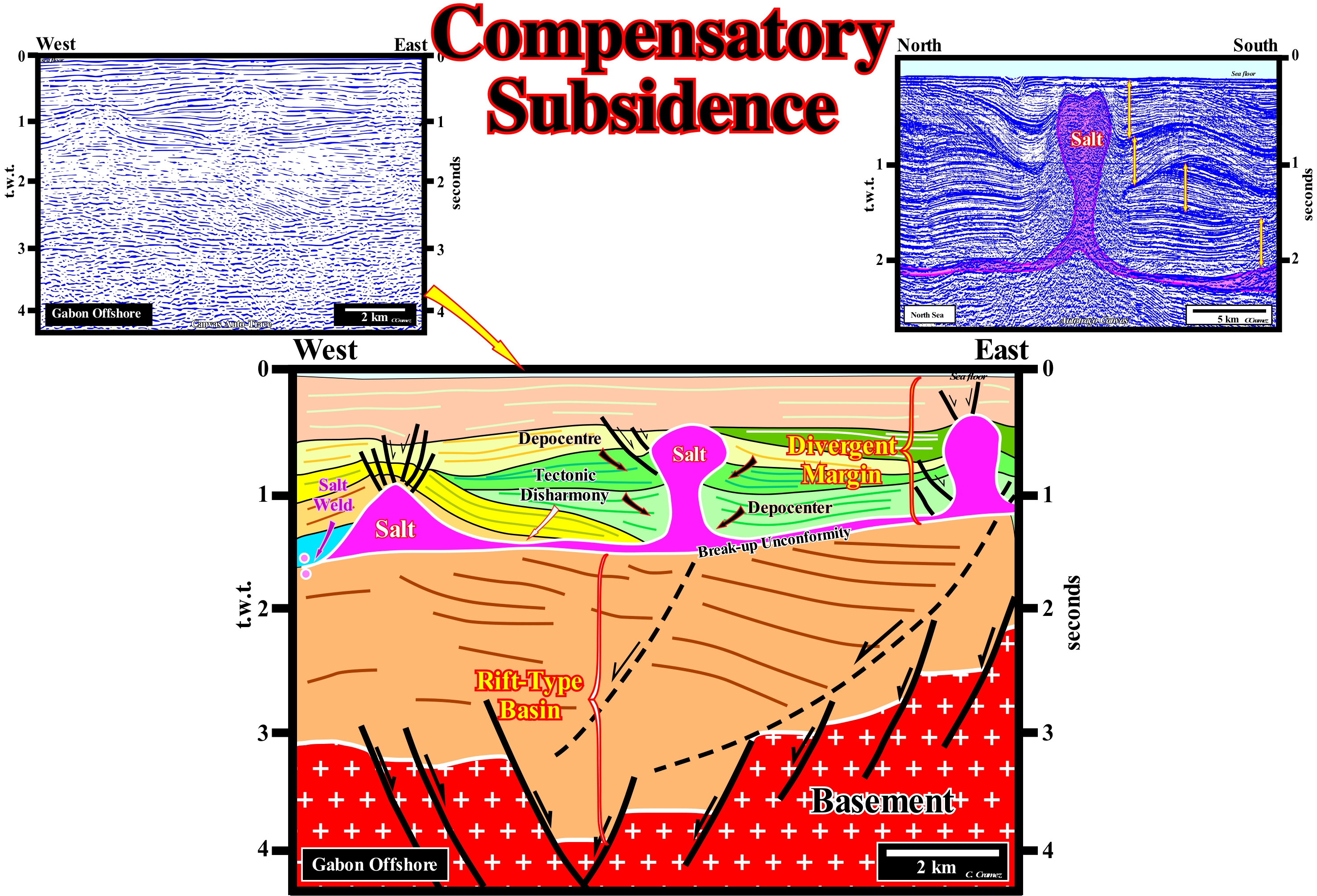
The Gabon offshore corresponds to the stacking of several basins of the classification of the sedimentary basins of Bally and Snelson (1980). On the regional seismic lines of this offshore, from bottom to top one can recognize: (i) A basement that, generally, corresponds to Precambrian rocks, or, locally, to a Paleozoic folded mountains belt ; (ii) Late Jurassic/Early Cretaceous rift-type basins, which lengthened the lithosphere of the Gondwana small supercontinent before it broke-up on several continents ; (iii) An Atlantic-type divergent continental margin in which a thick salt interval was deposited near the base of the margin. On this tentative geological interpretation of a Canvas auto-trace of an offshore seismic line, it is easy to understand what is a compensatory subsidence, which is here, created by the lateral and vertical flow of the evaporitic horizon. In this area, above the rift-type basin, whose upper limit is marked by the unconformity induced by the break-up of the lithosphere, a sandy interval of thickness less than the seismic resolution was deposited. This interval, which is not discernible in this auto-trace, as well as in most seismic lines, has been found in all petroleum exploration wells, which have reached the infra-salt sediments, may have petrophysical characteristics of reservoir-rocks. In this particular case, it can be said the unconformity induced by the breakup of the lithosphere of the Gondwana small supercontinent corresponds, seismically, to the base of the salt interval, which inclines slightly toward the deep part of the offshore. This slope underlines the obliquity of the divergent margin seaward. This geometry, as well as that of the rift-type basins, strongly contrasts with the geometry of the sediments postdating the deposition of the evaporites. The variations of thickness and internal configuration of the different post-salt intervals can only be explained by a compensatory subsidence created by salt flow. At the west end of this tentative interpretation (seaward of the last salt dome), the salt level disappeared, completely, creating a suture or salt weld (underlined by circles). When the salt flows (basinward or upward but not reaching the seabed), the overlying sediments collapse, creating available space for the deposition of new sediments (accommodation), which thicken towards the more subsiding zones that are, obviously, located around the salt domes. It is the halokinese, i.e., the movements of salt, independently, of all tectonic vector, which creates the tectonic disharmony between the infra- and supra-saliferous sediments. It is, perfectly, visible in this tentative interpretation. Salt movements are, mainly, induced by the density contrast between the salt (2.15/2.17) and the sediments, and by the fact that, conversely, to the sediments the salt does not compact in depth. This implies, in depth, a density inversion point, below which the salt is less dense than the sediments, which is not the case, above the point of inversion. This means that, theoretically, a salt dome can not have a cylindrical geometry (vertical walls). In fact, as above the inversion of density point, the lateral pressure, which the salt exerts against the sediments, is greater than the lateral pressure, which the sediments exert against the salt. It is why the salt flows, laterally, forming protrusions or salt overhangs, more or less, developed. Likewise, under density inversion point, the pressure exerted by the walls of a salt dome against the sediments is greater than the pressure exerted by the sediments against the salt. The salt flows vertically, in such a way that the walls of the salt dome take on a, more or less, accentuated biconcave geometry. At the same time, the depocenters of the surrounding sedimentary intervals, contemporaneous with the salt movements, approach the salt dome, due to a compensatory subsidence induced by the salt flow. In extreme cases, the upper part of the salt diapir may be, completely, disconnect from the lower part forming an inverted salt drop which is separated from the lower part of the old dome and the salt mother rock (autochthonous salt interval) by a secondary suture. Obviously, the formation of a drop or salt bulb promotes the formation of morphological traps by juxtaposition (against salt) at the bottom of these salt structures.
Competence (Stream).........................................................................................................................................................................................Compétence
Competência / Competencia / Kompetenz / 能力 / Несущая способность (течения реки) / Competenza (di una corrente) /
Ability of a stream or wind to carry debris. Competence refers more to the size of the transported particles than to the amount of particles. Competence is, generally, measured as a function of the diameter of the largest carried particle.
See: « Sedimentary Supply »
&
« River »
&
« Granulometry »
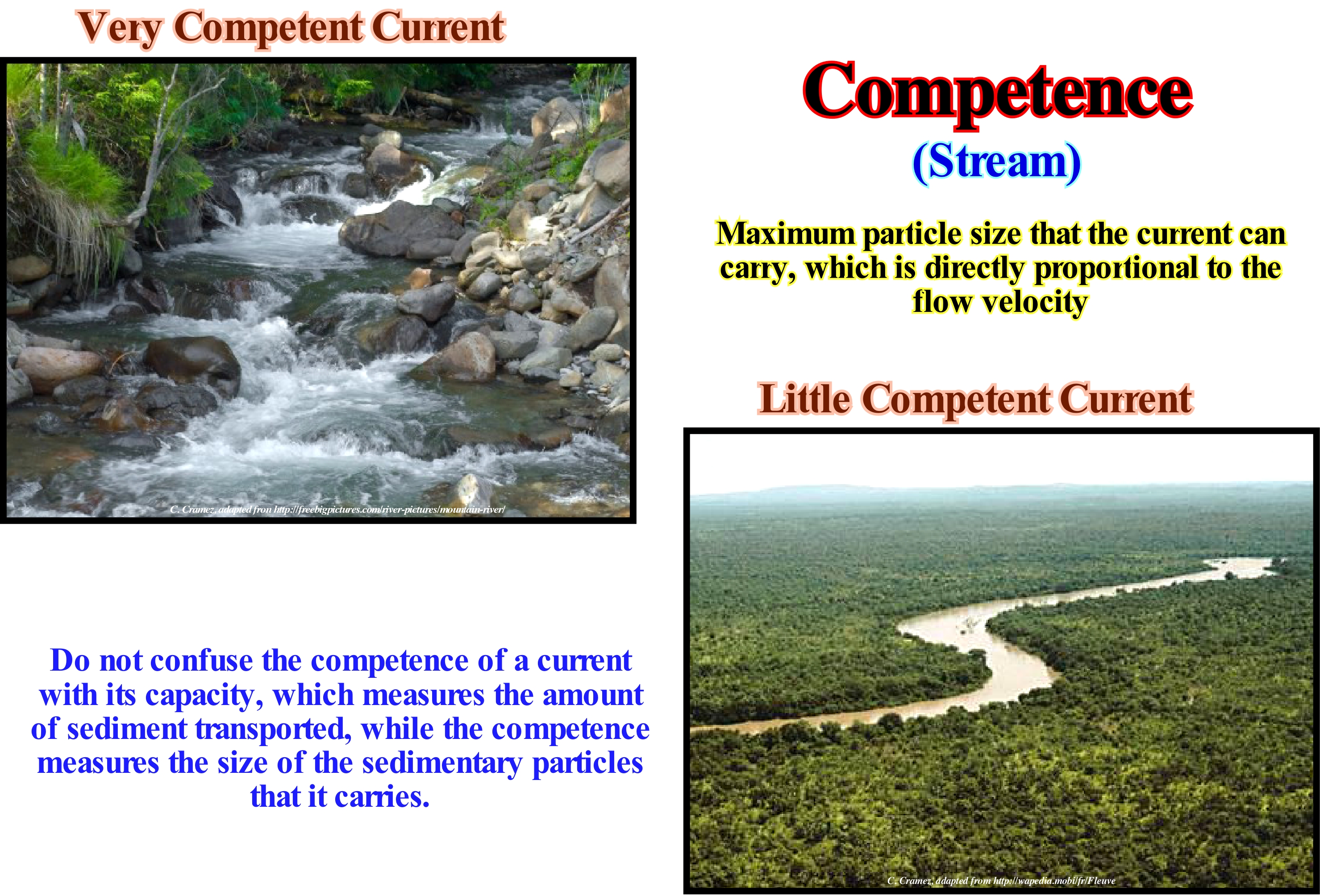
As shown in this figure, the diameter of the transported particles during flood periods, strongly suggests, these two water-courses have different competencies. All water-courses flow downstream due to gravity. The competence of a current reflects the possibility that it has to carry a particular size of sedimentary particles. With regard to the calculation of the capacity and competence of a current, all water movements have to be taken into account. Under normal conditions, the main factor controlling the competence and capacity of a water-course is the slope of the channel (also called the current gradient), which is the difference in altitude of the current divided by the distance between the two measuring points. The water flow velocity* is, directly, controlled by the inclination of the current bed (corresponds to the inclination of the thalweg). The greater the slope the greater will be the flow velocity. An increase in water flow velocity increases the current competence. In the present-time Mississippi delta, near the river's mouth, the competence and capacity of the current are minimal. In contrast, the Colorado River, whose bed descends through the Grand Canyon (where the thalweg inclines approximately 20 meters per kilometre), has a flow velocity that gives to the current a great capacity and competence. The channelling of water of a stream is, also, a critical parameter that affects, greatly, your ability and competence. This means that when the channel or bed of the current (where the current flows) is very narrow, the speed increases. When it is too wide the capacity and competence decrease. The amount of material carried by a stream is proportional to the velocity and gradient of the stream, which relates the amount of material transported through a point for a certain time. The higher the speed of a current the greater the amount of material carried. However, the velocity of a current is not constant. It maximizes a little below the surface, in the middle plane of the current and minimum in the bottom of the bed near the edges.
(*) The energy developed by a water-course, i.e., its erosional potentiality, is proportional to its flow (discharge or volume of the current at a given point) and to the square of its velocity: e= 1/2 m v2.
Competition (Organisms)..............................................................................................................................................................................Compétition
Competição / Competención (organismos) / Wettbewerb, Konkurrenz / 竞争 / Конкуренция (борьба) / Competezione, Concorrenza /
Negative interaction between two or more organisms that require the same limited resource. All organisms need resources to grow, reproduce, and survive. Animals, for instance, need food (eat other organisms) and water. Plants need soil nutrients (nitrogen, phosphorus, etc.), light and water. Organisms can not acquire a resource when others consume and defend it. Competition may reduce the likelihood of growth, reproduction and survival of competitors.
See : « Theory of Evolution "
&
« Commensalism "
&
« Clade "
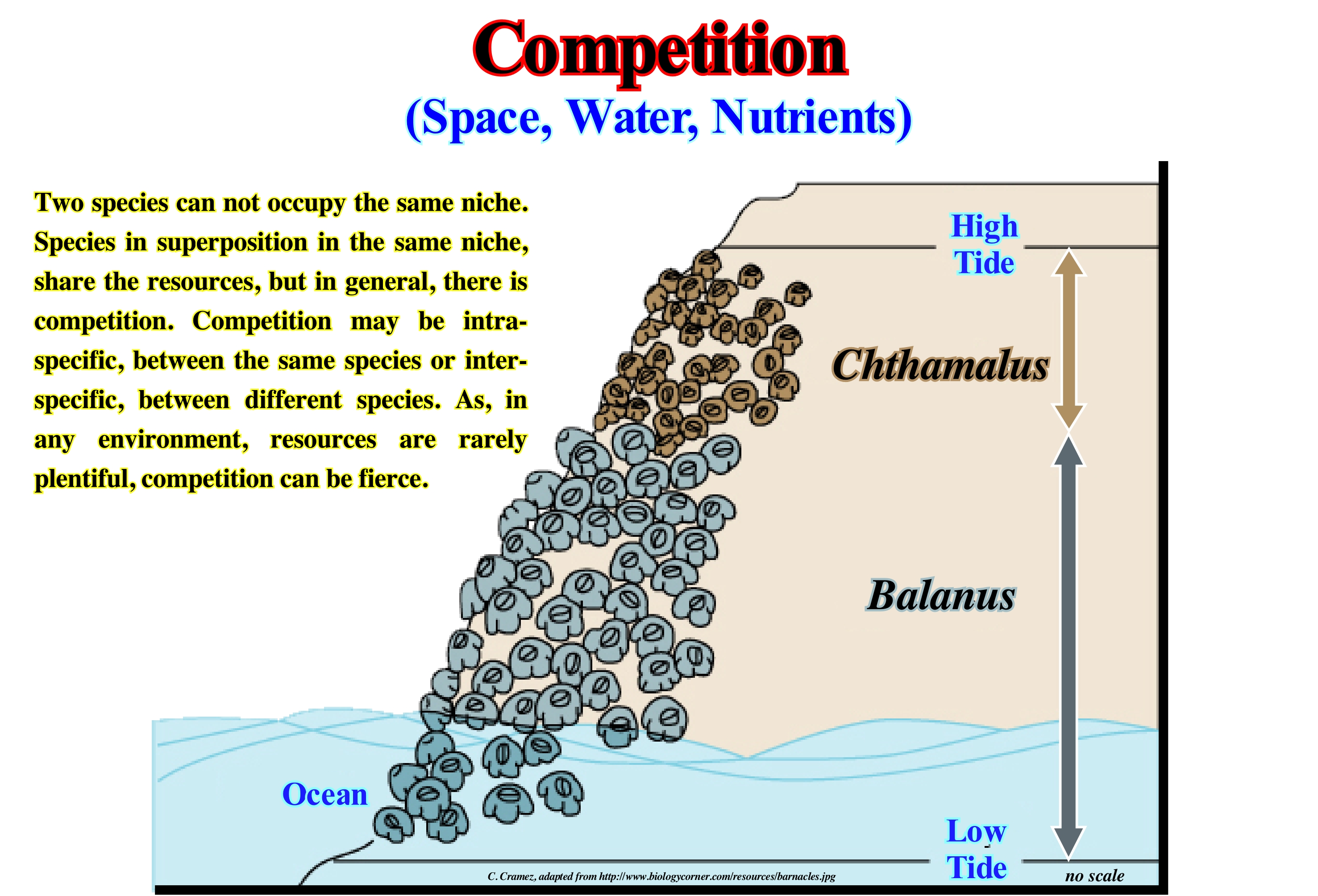
In ecology and biology, competition is the rivalry between living species to the access of environmental resources. Competition among members of a (intra-specific) species is the driving force behind evolution and natural selection*. Competition to natural resources, such as food, water, space, sunlight, etc., in the final survival is the domain of the species that best adapted to the survival. Competition exists, also, among species (inter-specific). If a limited amount of resources is available and several species may depend on these resources, each species competes with the others to gain access to those resources. As a result, species less adapted to obtain the resources or adapt or die. According to evolutionary theory, such competition plays a critical role in natural selection. So, for instance, if in a rainforest a small tree receives less sunlight than another tree that is beside it, the larger tree competes with the smaller tree for sunlight. Competition has been studied in a variety of fields, including psychology, sociology, and anthropology (a science that studies the reality of the human being through a holistic approach, i.e. the whole determines the behaviour of the parts). Psychologists, for instance, who study the nature of competition, investigate the natural desire for competition and their circumstances, and study, also, group dynamics to detect how competition arises and what its effects are. Sociologists study the effects of competition on society as a whole. Anthropologists study the history and prehistory of competition in various cultures and also investigate how competition has manifested itself in the past in various cultural contexts and how competition has developed over time.
(*) The concept of natural selection is one of the conjectures advanced by C. Darwin to explain the evolution of species that suggests populations have been able to evolve in their successive generations thanks to a mechanism (natural selection) in the reproduction of genotypes (set of genes inherited by a individual from their parents) according to environmental conditions, which hinder or benefit reproduction according to the characteristics of the organism.
Completeness................................................................................................................................Integralité sédimentaire (Complétude)
Integralidade sedimentar (Completude)/ Integralidad sedimentaria / Vollständigkeit / 完整性 / Осадочная целостность / Completezza /
Relation between the effective time of deposition and total geological time. If the time between two consecutive unconformities is, for instance, 3.0 My and the effective deposition time is 1.0 My, the sedimentary completeness is 0.3. In turbidite systems, the completeness is small, but the preservation is great. The deposition time of a deep turbiditic lobe (basin floor fan or slope fan) is practically instantaneous (in geological terms), while the time span between two consecutive lobes, during which, practically, nothing happen (from the point of view of deposition), can be thousands of years or more. The knowledge of completeness is essential to determine the sedimentation rate of a given sedimentary interval.
See: « Basin Floor Fan (submarine) »
&
« Delta »
&
« Geological Time »
Three questions come, always, to the spirit of geoscientists: (1) How long is a sedimentary layer deposited? ; (2) How long does a given stratigraphic section deposit? and (3) In comparison to the total deposit duration of a stratigraphic section, how long is there, actually, deposition? The answers to the first two questions are relatively easy: a) A beach deposit lamination is deposited in about one second ; b) A layer of HCS ("cross-stratification"), characteristic of storm deposits, is deposited in a few minutes ; c) A turbidite layer is deposited in a few hours ; d) Flood deposits, such as the Scablands (deposits and erosions associated with flooding caused by the behind retention rupture of lakes associated with the Pliocene/Pleistocene glaciers of Canada, are deposited in a few weeks ; e) The glacial varves deposit in 1 year ; f) One centimetre of pelagic sediments deposits in about 103 years ; g) A continental encroachment sub-cycle deposits in 10/20 x 106 years ; h) A continental encroachment cycle deposits in 100-200 x 106 years. In 1982, on this subject, P. M. Sadler showed that the duration of a deposit is inversely proportional to the sedimentation rate, that is to say, higher is the sedimentation rate, shorter the deposition period. From this, it can be deduced that most periods of no deposit escapes us, which led Ager to consider that sedimentary records correspond to short periods of terror separated by long periods of calm, where nothing happens. As all geoscientists know, in all stratigraphic systems, whether they are Silurian or Cretaceous, deposits are episodic, incomplete, and with numerous erosion and non-depositional hiatus. The deposits do not translate in any way the equivalent duration of geological time. In the stratigraphic sections, whether they are deep-water or not. The time of no deposition and erosion is almost always greater than the actual deposition time of the preserved sediments. As illustrated in this figure, this is particularly true in turbidite deposits and coastal deposits. In the upper part of this figure, in the stratigraphic models (progradational shoreline, i.e., during sedimentary regressions and turbidite depositional systems) it is important to note in the upper part of each section the duration of the periods of non-deposit is largely higher to the periods of deposition. Most of the geological events that occurred during these periods were not preserved. The completeness or sedimentary integrality of a deposit is given by the ratio of the deposition time to the total time (depositional time plus hiatus). Turbidite deposits and, in particular, submarine basin floor fans have a very small completeness. The deposition time of each turbidite layer is, geologically, instantaneous, but the time between two consecutive turbidite currents, during which the pelagic shales are deposited, is very large, sometimes more than 1 My. If in a submarine basin floor fan, composed of 100 turbidite layers and pelagic shales in which each turbidite layer has a thickness of 20 cm and each pelagic layer has a thickness of 5 cm, the total thickness is of 2500 cm. As the average deposition rate of pelagic shale is, say, 5 cm/1,000 years and the turbiditic currents are instantaneous stratigraphic events, it can be deduced: a) Total deposition time was 100,000 years and b) The frequency of turbiditic currents is 1,000 years, which means that two-thirds of the sedimentary interval has been deposited by instantaneous events, the frequency of which is one event every 1,000 years. On the other hand, it is important not to forget most of the sediments associated with the different geological events occurring during the deposition periods are not preserved. In fact, the preservation of the stratigraphic sections is related to: (i) Amplitude; (ii) Frequency of stratigraphic events and (iii) Depositional environment. The stratigraphic events most represented in the stratigraphic records are those that have normal or low frequency,i.e., those that occur sporadically. In terms of frequency. As said above within a sequence cycle, the basin and submarine slope fans are very significant since the turbidite levels contrast sharply with pelagic intervals between them. Pelagic stratigraphic intervals are events of normal frequency, whereas turbidite intervals are associated with events, geologically, instantaneous.
Complex Filling.................................................................................................................................................................Remplissage complexe
Preenchimento complexo / Relleno complejo / Füllung Komplexe / 复杂的填充 / Комплексное заполнение / Riempimento Complesso /
When an interval between two unconformities or a bathymetric anomaly is filled by sedimentary packages with an disordered and non-concordant internal reflection configurations between them.
See: « Onlap »
&
« Reflection Configuration »
&
« Relative Sea level Change »
On this tentative geological interpretation of a Canvas auto-trace of a detail of a Texas offshore seismic line, the external pattern of a channelling structure is obvious. The unconformity (in red) can be evidenced by the underlying truncation and overlying downlaps and onlaps. The geometry of the discontinuity* is concave upward and resembles the shape of a channel. The sedimentary intervals, overlying the discontinuity, have very varied internal configurations and the relations between them are discordant. Therefore, it can be said the sedimentary filling of this channelling anomaly is complex. However, this disconformity does not appear to be, directly, associated with a relative sea level** or with the absolute sea level*** fall, as are the unconformities (erosional surfaces) bounding the different stratigraphic cycles. The unconformities limiting the stratigraphic cycles correspond to erosional surfaces, along which, by definition, there is no deposition but erosion. However, at the sequence-cycle hierarchical level, this is not true, in the deep-part of the basin, where turbidite depositional systems can be deposited over the correlative deep-water para-conformity of the unconformity. Indeed, within a sequence-cycle (induced by 3rd order eustatic cycle, i.e., an eustatic cycle with a duration between 0.5 and 3-5 M), during the period of relative sea level fall (decreasing in accommodation), just in the deeper part of the basin, submarine basin floor fans (SBFF) and submarine slope fans (SSF) are deposited, which underline the minimum hiatus between the sequence-cycles separated by the unconformity. In practice, the age of the submarine basin floor fans gives, with a minimum of error, the age of unconformity with which they are associated i.e., the age of relative sea level fall. In this particular case, taking into account the coastal plain context where the original seismic line was shot and the reflector terminations visible on this tentative interpretation, the most likely is that this disconformity was induced by a fluvial incision in association with the curvature of a meander. The progradations, visible in the upper left part of this tentative interpretation, were deposited at same time that the point bar (in the convex part of the meander). Similarly, in the opposite concave part, where the river water flowed with more energy, there was erosion. This means that the onlaps can not be interpreted as induced by relative sea level rises. Likewise, the boundaries between the different sediment fill packages (clay-plugs) do not correspond to unconformities. These packages do not emphasize stratigraphic cycles. Clay-plugs correspond to the partial sedimentary fillings of the different abandoned meander lakes, every time, the main bed of the water-course has changed trajectory. In this type of deposits, as in others, when deposition and erosion are coeval and interconnected, in terms of sequential stratigraphy, one should not speak of unconformities, i.e, more or less, generalized erosional surfaces, at least, at the level of a sequence-cycle.
(*) A discontinuity designates a transition or contact between different density intervals, such as Mohorovičić, discontinuity or different sedimentary facies (lithologies) or even between intervals separated by a hiatus (absence of significant deposition). That is to say, that there are several types of discontinuities: 1- Stratigraphic ; 2- Sedimentary ; 3-Lithological ; 4 - Tectonic, etc., Among the lithological discontinuities, which are the most important in sequential stratigraphy, we can recognize: (i) Concordant discontinuities, when there is continuity between successive intervals ; (ii) Paraconform Discontinuities or Para-conformities, when there is no difference in attitude between overlapping intervals, but there is a hiatus due to the absence of significant deposition between them ; (iii) Non-Conform Discontinuities or Non-conformities (which certain authors call Heterolithic Discordances), when there is a contact between a sedimentary interval and an older igneous body ; (iv) Disconform Discontinuities or Disconformities, when the layers of the hiatus are parallel on either side of the contact surface which does not conform to the regional stratification ; (v) Discordant Discontinuities or Unconformities when the two intervals are separated by an erosional surface induced by a relative sea level fall ; (vi) Enhanced Discordant Discontinuities or Tectonic Enhanced Unconformities, when the sediments of the interval underlying an unconformity were deformed by tectonics (shortened or lengthened ; (vii) Intrusive Discontinuities, when an igneous body traverses a sedimentary series ; (viii) Mechanical Discontinuities, when they are induced by faults, etc. (https://estpal13.wordpress.com/2013/06/04/descontinuidades-sedimentares-e-estratigraficas/)
(**) Local sea level referenced to any point on the Earth's surface (sediment base, sea bed, etc.)
(***) Global sea level referenced to the Earth's center.
Complex Mound........................................................................................................................................................................Monticule complexe
Montículo complexo / Montículo complejo / Komplexe Hügel / 复合丘 / Комплексный холм / Monticello Complesso /
A mound-shaped structure, in a geological or seismic section, in which the internal configuration of the associated stratification planes or reflectors has a very complex geometry.
See: « Climbing Toplap Mound »
&
« Reflection Configuration »
&
« Chaotic Mound »
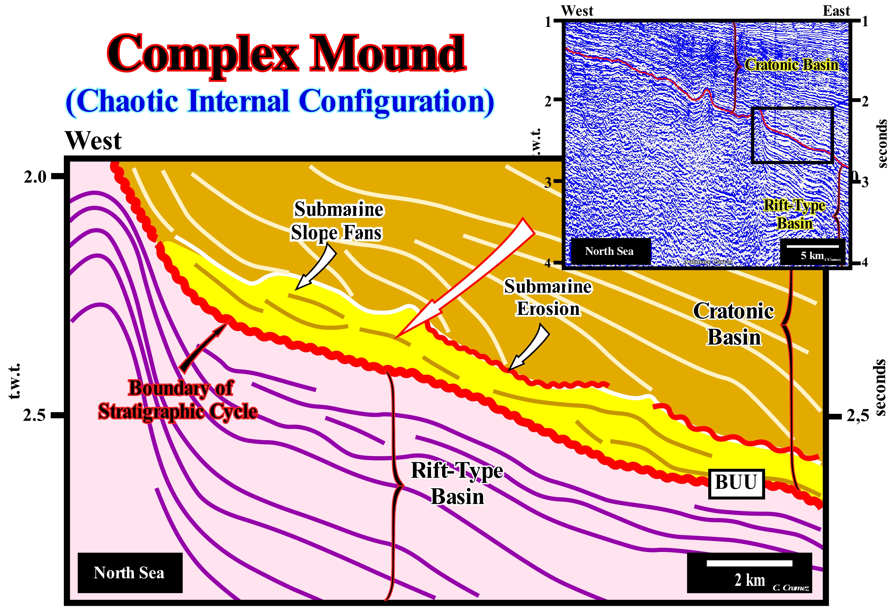
On this tentative geological interpretation of a Canvas auto-trace of a detail of a North Sea regional seismic line, sedimentary anomalies located at the base of the cratonic basin (which developed on the ancient continental crust and which is, generally, created by a regional thermal subsidence) suggest, strongly, turbidite deposits on the continental slope. The morphology of these anomalies and the internal configuration allow them to be considered as examples of complex mound structures. As suggested on this tentative interpretation, these anomalies are, probably, submarine slope fans (SSF) that have been slightly eroded by contour currents (narrow, well-defined intense water currents flowing off the western continental margins of ocean basins). The formation of these structures has been well described in the literature. In this particular case, these anomalies fossilize, largely, the BUU unconformity (correlates, laterally, with the true breakup of the lithosphere of the Pangea supercontinent), which separates a rift-type basin from the North Sea cratonic basin. This unconformity (erosional surface or its correlative deep-water paraconformity) corresponds to a change in the type of subsidence. In the rift-type basin, subsidence was differential (lengthening of the continental crust of the supercontinent lithosphere, which can just be done, in a significant way, by normal faulting). During the cratonic basin subsidence was thermal (re-balancing of isotherms). Subsidence may correspond to a cooling of the Earth's surface. The origin of subsidence may be a sedimentary load, a tectonic activity or a thermal contraction during the crust cooling. Actually, sedimentary basins are not produced by sedimentation, but by tectonic and thermal processes. When a basin forms, by lengthening, normal faults force sedimentation into the basin, but this does not seem to be enough to form a sedimentary basin. A deep lithospheric cooling (thinning of the isotherms) induces a thermal contraction to recover the isostatic equilibrium, which causes, naturally, a thermal subsidence that plays, normally, the main role in the evolution of the basin after the tectonic subsidence ceases. In the North Sea, the westward displacement of the thermal anomaly of the lithosphere of the Pangea supercontinent, responsible for the lengthening of the continental crust ("rifting" or lengthening phase), had several consequences in this area: (i) Rift-Type Basins (end of the lengthening) ; (ii) Westward displacement of the lithosphere's break-up of the Pangea supercontinent ; (iii) BUU unconformity (break-up unconformity) induced by lithosphere's breakup ; (iv) Absolute (eustatic) sea level rise, since the volume of the ocean basins increased (formation of oceanic ridges) ; (v) Formation of a cratonic basin by thermal subsidence to balance the isotherms, by cooling and thermal contraction of the deep lithosphere in order to recover the isostatic equilibrium broken by the thermal anomaly and the associated differential subsidence ; (vi) Deposition of submarine basin floor fans and submarine slope fans, immediately, above the BUU unconformity*, probably, under highstand geological conditions (Mutti's deposition model) in association with landslides and failures of continental edge and continental slope, as well as, with periods of river flooding. These submarine slope fans can be considered as sedimentary anomalies of the complex mound type. As can be seen on this tentative interpretation, the upper limit of the submarine slope fans, which at the time of deposition was, more or less, continuous, later, was eroded, probably, by contour currents. These contours currents carried the erode sedimentary particles, not very far, to deposit them as contourites (sandy bodies, generally re-deposited by contour currents, which may contain a large amount of heavy minerals such as allanite, zircon, tourmaline etc.), which in this area are characterized by a deposition angle of about 10-15°, which strongly contracts with the dip of the submarine basin floor fans.
(*) On this tentative interpretation, in deep-water, it is better to say over the lower stratigraphic cycle boundary, since the unconformity passes, laterally and in depth, to its correlative paraconformity.
Complex Shaped Delta (Polymorphic delta)...................................................................................................Delta complexe
Delta complexo/ Delta complejo / verwickelt Delta / 复杂形三角洲 / Дельта со сложным строением / Delta complesso /
Delta characterized by a large extension of the delta plain, in which the dynamic irregularities produce a great variety of morphologies. Locally, in a complex shaped delta, lobate, arcuate, atrophied or cuspate delta morphologies can be find.
See: « Delta »
&
« Deltaic Plain »
&
« Foreset Bed (delta) »
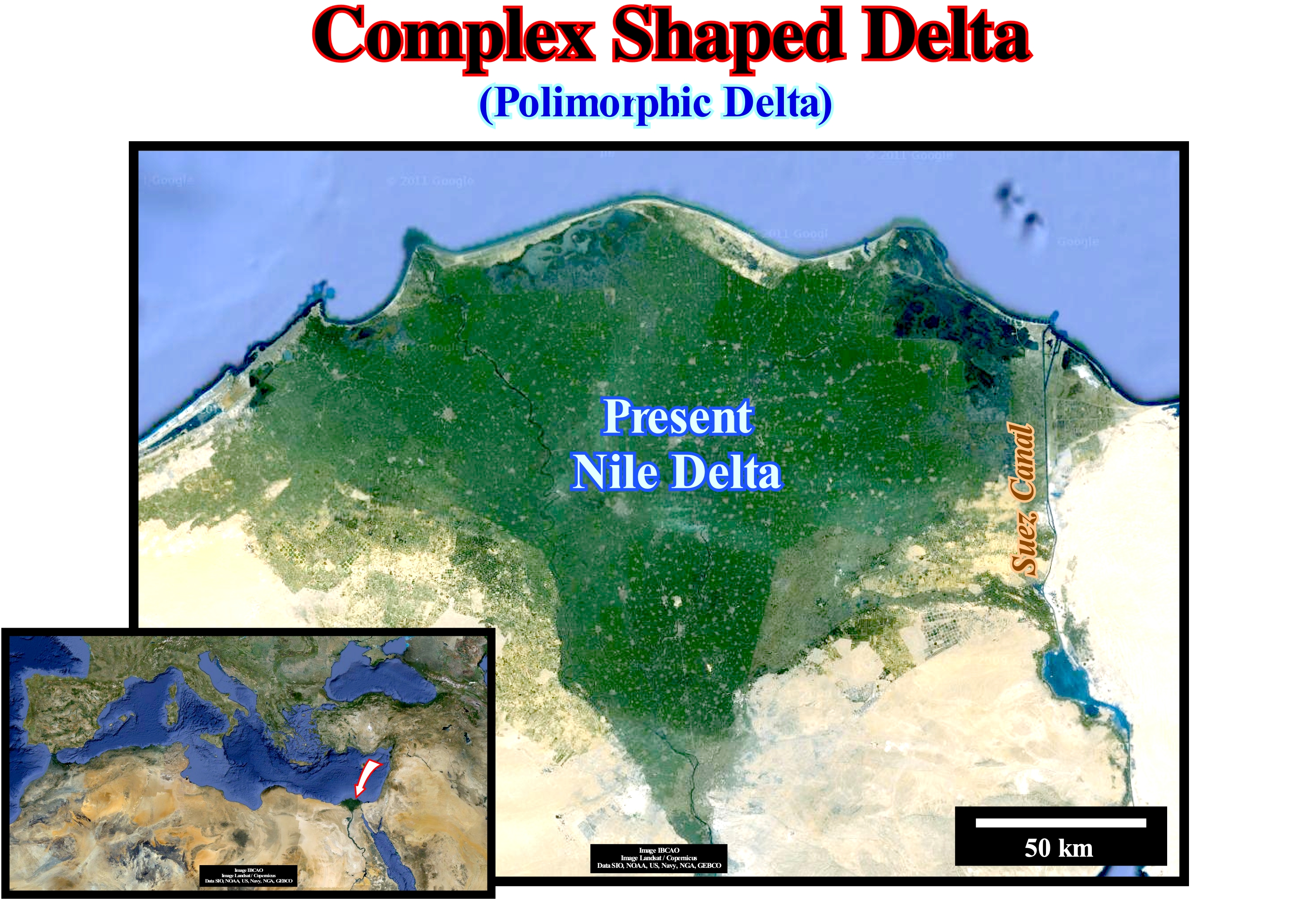
The Nile delta is located in the north of Egypt, where the Nile River deposited a huge delta building, as its mouth advanced seaward. This delta building is one of the largest in the world. It begins a little south of the Cairo city, where the delta apex is located (the point of the diffluence* of the fluvial channel, which is more upstream and which marks the upper limit of the delta) and extends until to the Mediterranean Sea over a distance of about 160 km and with a thickness of several kilometers. The deltaic shoreline is about 240 km, between the cities of Alexandria, at West, and Port Said, at East. The delta building is, basically, of complex type. In fact, locally, in association with the different distributives (streams that flow out of the main channel of the river), which compose it, several morphologies can be observed, as the suggests the geometry of the coastline. The fluctuations of the river always exerted a strong influence on the development and morphology of the delta building and, subsequently, on the location of the settlements and plantations. In the time of Herodotus (between 484 and 420 BC), the Nile delta had five branches, which from West to East were: (i) Canopic Branch from the name of Canopo city (near the Abukir city) ; (ii) Saitic Branch, from the name of the fifth name of Sais or Sa el-Hagar ; (iii) Sebenitic Branch, in honour of the name of Sebenitos ; (iv) Mendesian Branch, named after the gulf of Djedet (now Tell El-Ruba) and (v) Pelusiac Branch, named after the city of Pelusio. At present time, there are just two branches that are known as the Roseta (about 65 km east of Alexandria) and Damietta branches. For thousands of years, the settlements, in Lower Egypt, protected from the floods and variations of the Nile's flow, settling on the sand mounds (turtle backs* of the Egyptians), which are geological remnants, that the pre-Nile formed around15,000 years ago. Unfortunately, since the Aswan dam was built, in upper Egypt, which aimed to regulate floods, irrigate millions of square kilometers of desert and obtain cheap energy for the country's industrialization, the delta no longer receives any nutrient and sedimentary influx from the water-courses upstream of the dam, which has disastrous consequences for the environment: (i) The flood-plain soils have become almost barren, requiring populations to use huge quantities of fertilizers with all the consequences that this entails ; (ii) The arable layer of the soil, which before the dam could reach a thickness of about 2 meters, is now much smaller, which inevitably has produced a rise and contamination of the water-table ; (iii) The erosion of the delta has increased in a frightening way (several tens of km2 per year), which leads some geoscientists to believe the Nile delta will, probably, not survive this millennium. To make matters worse, Ethiopia is planning to build a dam (Renaissance) to stockpile water, produce energy and irrigate its crops. Until very recently, according to the agreements signed with Sudan and Ethiopia, Egypt receives about 55 million cubic meters of Nile water. However, times have changed, populations have grown and the region's energy needs as well. The war for water is intensifying and must be further aggravated in the future. As most geoscientists say, mankind can live without oil, but without water is another history. Other types of delta can be considered as a function of the dynamics of the delta and the shape of the emergent plain: (i) Abandoned Delta or sub-delta ; (ii) Alluvial delta ; (iii) Arctic Delta ; (iv) Rounded Delta; (v) Atrophied Delta ; (vi) Cuspate Delta ; (vii) Finger Delta; (viii) Flood Delta; (ix) Closed Delta ; (x) Gilbert-type Delta ; (xi) Lava Delta ; (xii) Lobated Delta ; (xiii) Tidal Delta; (xiv) Submarine Delta ; (xv) Storm Delta ; (xvi) Wave Delta ; (xvii) Ebb Delta.
(*) Diffluence is when a water-course splits into two or more arms that do not join downstream. The diffluent (tend to flow off or away) is, generally, distinguished from the main stream. The term is also used in glaciology. The typical case of diffluence is with the different arms of a delta.
(**) These topographic anomalies called "turtle-backs" have nothing to do with the tectonic inversion structures induced by lateral and vertical movement of the salt interval, such as those found in the Kwanza geographic basin (Angola) that the geoscientists of Petrangol (a subsidiary of the former petroleum company PetroFina) denominate "turtle-backs".
Complex Sigmoid Oblique Configuration.................................Configuration sigmóide oblique complexe
Configuração sigmóide oblíqua complexa/ Configuración compleja sigmóide oblícua / Komplexe Sigmoid-schräge Konfiguration / 复杂乙状肠-斜配置 / Комплексная Сигмообразно-наклонная схема / Configurazione Complesso sigmoidale-obliquo
Particular case of a sigmoid configuration, in which the inclination of the median sector of the progradations (seaward dipping sector) is very high and the presence of truncation toplaps is frequent.
See: " Stratal Pattern "
&
« Reflection Configuration »
&
“ Marine Regression ”
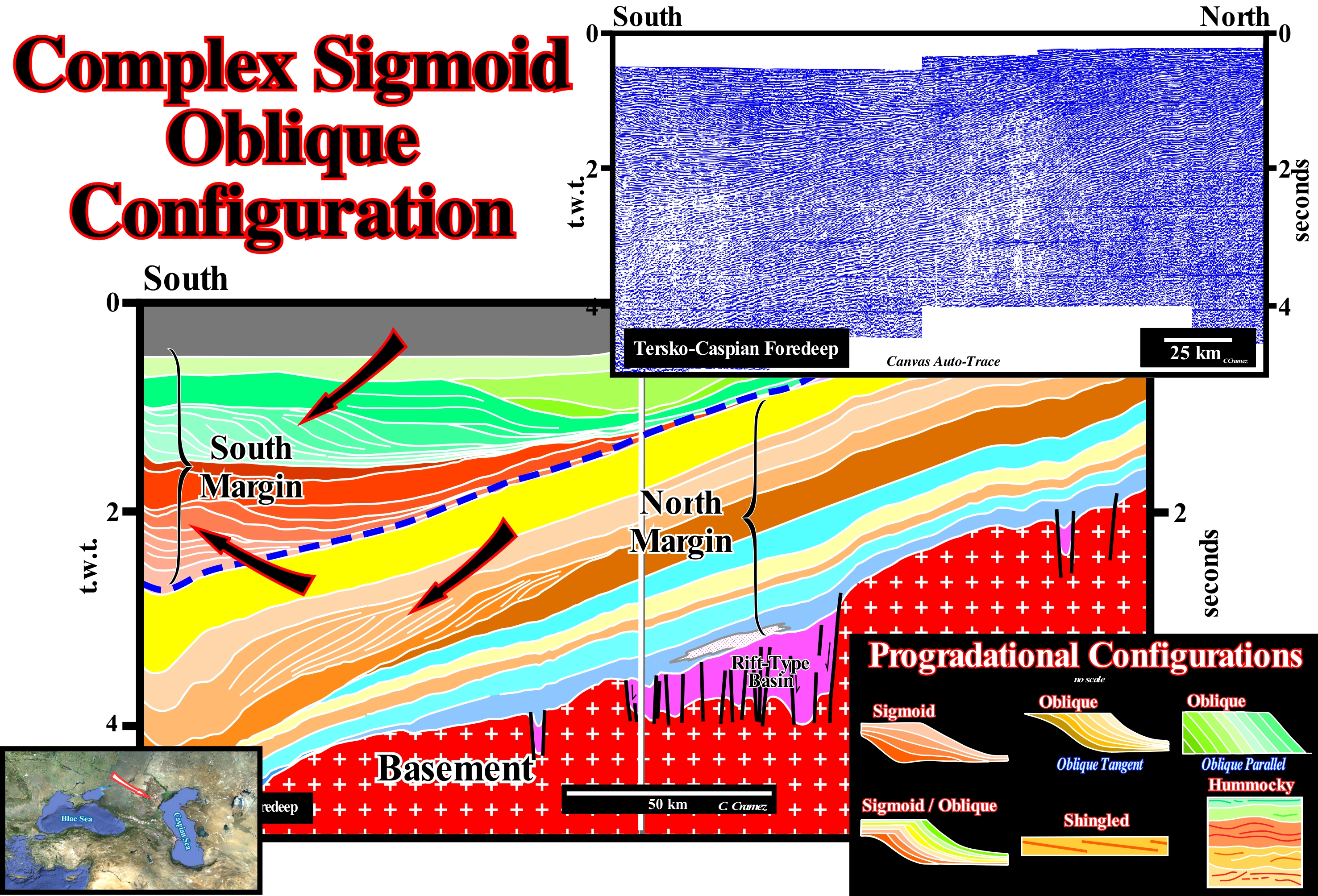
The onshore NW of the Caspian Sea corresponds, in the classification of the sedimentary basins of Bally and Snelson (1980), to a folded belt resulting of the collision of two Atlantic-type divergent margins. On this tentative geological interpretation of a Canvas auto-trace of a regional seismic line of this onshore, complex and oblique tangential progradations are. easily, recognized. Theoretically, this type of progradation can be interpreted as clinoform surfaces constituted by the lateral accumulation of a certain number of oblique layers ending upstream, by toplaps (by non-deposition or by erosion) and downstream (towards an old sea) by downlaps. Certain progradations do not exhibit any aggradation (pure oblique progradations) and terminate, downstream, abruptly (practically without lower sector). The progradations are constituted, just, by the oblique segment that corresponds, taking into account the scale, to a continental slope. In sequential stratigraphy, it is often said a progradational sedimentary interval has a complex internal configuration, when the oblique and sigmoid progradations alternate in a, more or less, disordered manner. As can be seen, in this tentative interpretation, there are two main sedimentary intervals with this type of internal configuration. These intervals are separated by sedimentary intervals of, more or less, constant thickness with a parallel internal configuration (not shown in this tentative). Each of these progradational intervals represents the northward displacement (upper interval) and the southward displacement (lower interval) of the continental slope of two continental divergent margins with opposite polarities (opposite slopes). At each of these intervals there are several limits of stratigraphic cycles, i.e., several unconformities induced by significant relative sea level falls that have displaced seaward and downward the coastal onlaps (negative aggradation). As a result of the collision between the divergent margins, the sea between them closed, gradually, as the two continental margins (different lithospheric plates) approached one another. Finally, when the two plates collided, the sea closed completely. The sea between the margins was the Tethys Sea, which corresponded to an enormous gulf of the Pangea supercontinent separating two large continental masses: (i) The Laurasia small supercontinent to the north and (ii) The Gondwana* small supercontinent to the south. As in plate tectonics kinetic energy plays no significant role, the term collision, used here, has a very different meaning from that used in everyday language. The sediments of the lithospheric plates are deformed because they have lost resistance to deformation and not because they collide against each other (such as the collision between two automobiles, in which kinetic energy is transformed into "deformation" energy). Throughout a tectonic plate, effective stresses are constant. It is the resistance of the sediments to the deformation that changes. The internal progradational configurations of the seismic intervals are schematised in the lower left corner of this figure: (i) Sigmoid Configuration, when the progradations have a geometry of a S upside down, that i.e., the slope in the upper and lower parts is relatively small, while in the median sector it is much stronger ; (ii) Oblique/Tangent Configuration, in this pattern, the seismic reflectors have a decreasing slope basinward ; (iii) Oblique/Parallel Configuration, which corresponds to a set of seismic reflectors with a parallel/oblique pattern, in which the progradations end up, downstream, with a relatively important dip ; (iv) Sigmoid/Oblique Configuration, which is a particular case of the sigmoid configuration, in which the dip of the median sector of the progradations is very strong and the presence of toplaps by truncation is frequent ; (v) Shingled Configuration, when the progradations are oblique and almost lying down, seeming to take turns one after the other and (vi) Hummocky or Wave Configuration, that corresponds to a set of seismic reflectors with opposite slopes, interpreted as strata associated with slope turbidite deposits (levees or natural turbiditic marginal dikes and the fillings of depressions between them or of channels, in case of obvious erosion, where currents have travelled).
(*) In the palinspathic reconstitutions of the continental masses, geoscientists often consider supercontinents, which designate large land clusters that encompass most of the Earth's emerged land, such as Vaalbara, Kenorland, Columbia, Rodhinia, Pannotia, Pangea. Supercontinents are formed by small supercontinents such as Laurasia or Gondwana. The small supercontinents are made up of continents, such as the Baltica or Siberia.
Concentration Current (Rip current)......................................................................................Courant de concentration
Corrente de concentração (corrente dos agueiros) / Corriente de resaca (de las rompientes) / Ripströmen / 離岸流 / Разрывное течение / Corrente di ritorno, Corrente di risacca, Corrente di risucchio /
Transverse or oblique current to the shoreline, flowing seaward, affecting the superficial and deep-water mass. Beyond the surf zone, the concentration current opens into fans, dividing into branches that return to the shore, in the surfing area, with the uprush current. Synonym of Rip Current.
See: « Uprush Current »
&
« Surge Current »
&
« Rip Current »
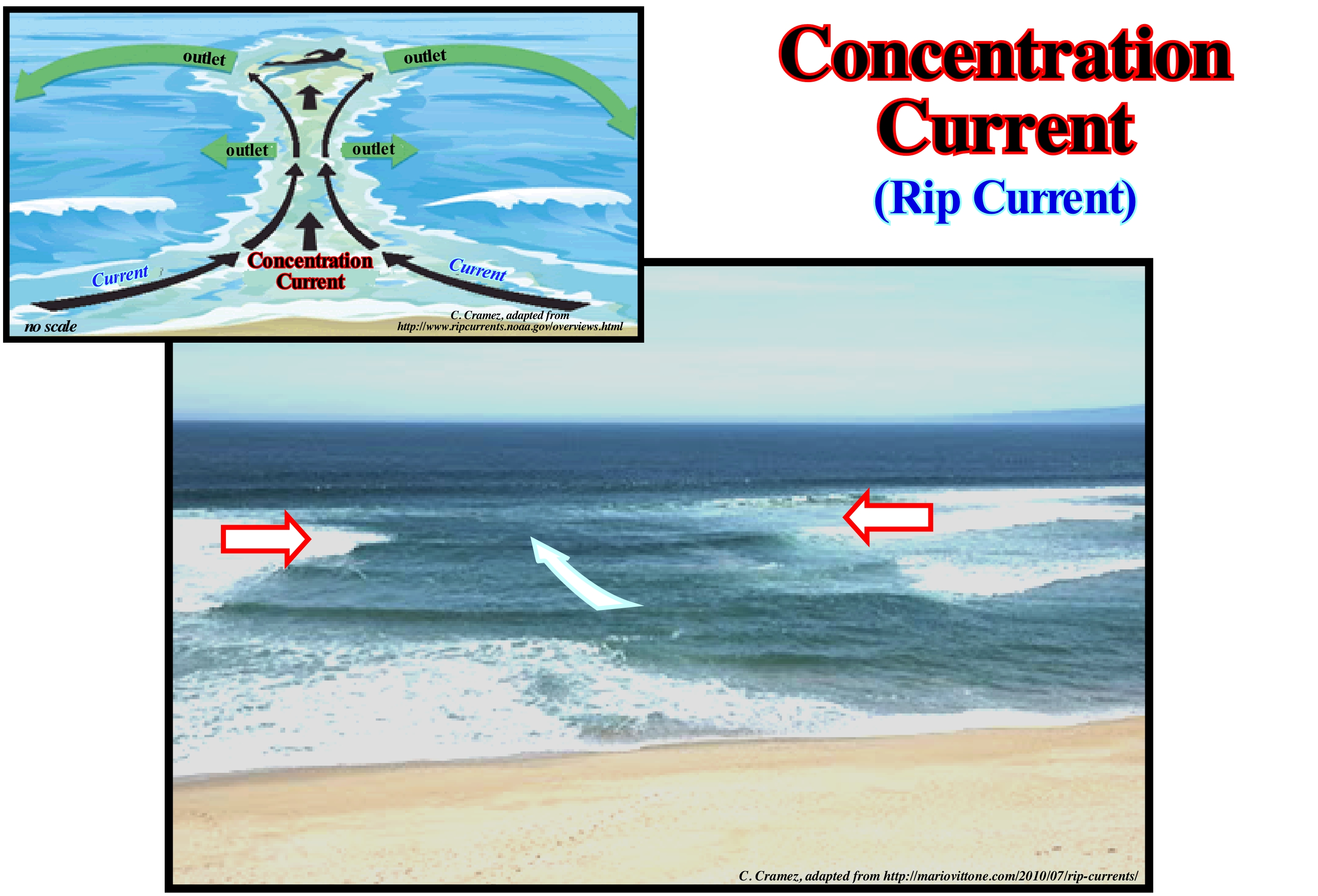
As shown in this photograph, a current of concentration is a horizontal current that should not be considered as a undertow current (current, which for some geoscientists flows out as the backwash current). Contrary to an idea that many people advance, a concentration current does not take people to the bottom of the water, but rather away from the coast. Drowning deaths occur when people who are taken away from shore are not able to keep floating and swim to the coastline, which is, usually, due to the combination of: (i) Fear ; (ii) Panic ; (iii) Exhaustion and (iv) Mediocre swimming qualities. Concentration currents are, especially, frequent after the storms. Some of these currents occur just for a few hours, while others may be, more or less, permanent. To avoid a concentration current, do not forget that it is recognized by: (a) A channel of agitated water ; (b) An area perpendicular to the coast where the colour of the sea is different and where the foam, algae and plant remains move, rapidly, seaward and (c) Above all, a break in the wave approaching the coast. On the other hand do not forget to: (1) Learn to swim ; (2) Never swim alone ; (3) Always pay attention, especially, when swimming on unsupervised beaches ; (4) Swim, whenever possible, on the beach with surveillance. If you are still caught in a concentration current, remain calm, conserve your energy, and do not try to fight the current. Swim out of the stream parallel to the coastline (these currents reach, rarely, more than 10 meters wide) and when out of the stream swim in the direction of the coast. If you are not able to swim out of the current, let yourself float or swim in the direction of the current until you get out of it. Once you are out of the current, swim, calmly, towards the coastline.
Concordance.............................................................................................................................................................................................................Concordance
Concordância/ Concordancia / Konkordanz / 和谐 / Согласное залегание / Concordanza /
When a stratum or a seismic reflector is parallel to a stratigraphic cycle boundary or when there is no evidence of a stratum or reflector termination against it. A concordance does not imply, necessarily, an absence of erosion. A certain amount of erosion occurs at the limits of a stratigraphic cycle. The time-span associated with an unconformity or a non-conformity may represent a, more or less, prolonged periods of sub-aerial exposure with a minimum of erosion, such as in incised valleys and submarine canyons, which can be, often, smaller than the seismic resolution.
See: « Unconformity »
&
« Sequence Boundary »
&
« Relative Sea Level Fall »
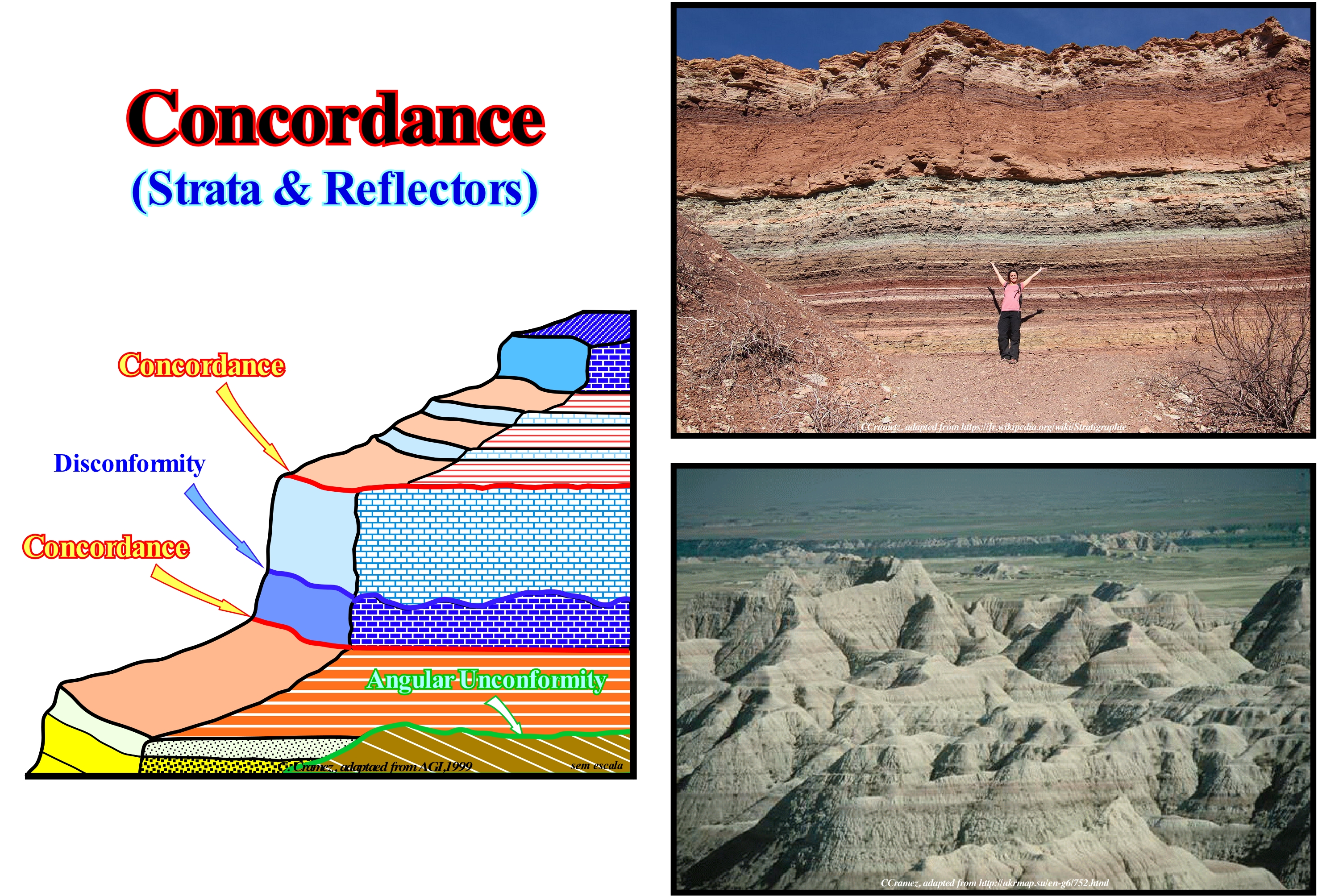
Two sedimentary intervals are concordant when they have the same direction and dip and when the deposits follow each other, without interruptions or significant changes in the lithology of the strata or the fossils they contain. A concordance assumes uniform sedimentation conditions following a normal sequence of geological time. Discordant deposits occur when the sedimentation processes are interrupted by a period of erosion. If a deposit of new rocks is deposited on a series of older rocks having undergone a process of erosion and transport, the most recent deposit is discordant and emphasizes a rupture in geologic time. Their stratification plans are not parallel to the stratification plans of the older rocks. It may be said that an unconformity is induced by a relative sea level fall, produced by the combination of absolute (eustatic) sea level and tectonic (uplift or subsidence of the sea floor). A concordance implies a relative sea level rise followed by a stability period of of the relative sea level during which deposition occurs. The surfaces associated with a hiatus are bedding plans when the gap is small and unconformities or discontinuities (disconformities), when the gap is important. The unconformities which, in the vast majority of cases, are induced by significant relative sea level falls, which put the sea level lower than the basin edge, may in some cases be tectonically enhanced ("enhanced unconformity"). In this case, they are, often, referred as angular unconformities and recognized, easily, either in the field or on the seismic lines, by the terminations of the associated strata or reflectors. When unconformities are not reinforced by tectonics, they are relatively well recognized on the basin edge, either by the coastal onlaps of the lowstand prograding wedge of the overlying sequence-cycles or by the erosion associated with the incision of the submarine canyons (when present). Landward of the basin edge, when the basin has a shelf (highstand geological conditions) or in the coastal plain, when the basin has no shelf (lowstand conditions), the unconformities (erosional surfaces induced by a significant relative sea level fall) may be evidenced by the filling of the incised valleys and submarine canyons. In all other cases, the unconformity identification is, relatively, difficult, especially on the seismic lines. The difference between a discontinuity or nonconformity (wavy disconformity), which may or may not correspond to an unconformity, and a concordance is very subtle and practically impossible to do on seismic lines due to the limit imposed by the seismic resolution, which ranges, generally, between 30 and 50 meters. For many geoscientists, a discontinuity denotes a transition or contact between intervals of different densities, as in the case of A. Mohorovičić's discontinuity or with facies (lithology with a more or less characteristic feature deposited in a particular sedimentary environment) or a contact between intervals separated by a hiatus (absence of major deposition). Several types of discontinuities can be considered: (1) Stratigraphic ; (2) Sedimentary ; (3) Lithological ; (4) Tectonic, etc. Within the lithological discontinuities, which are the most important in sequential stratigraphy, we can recognize: (i) Concordant Discontinuities, when there is continuity between successive intervals ; (ii) Paraconform Discontinuities or Paraconformities, when there is no difference in attitude between overlapping intervals, but there is a hiatus due to the absence of significant deposition between them ; (iii) Nonconform Discontinuities or Nonconformities (Heterolithic Discontinuities of certain geoscientists), when there is contact between a sedimentary interval and an older igneous body ; (iv) Discontinuous Discontinuities or Disconformities, when the layers of the different intervals are parallel on one side and the other side of the contact surface which is not in accordance with regional stratification ; (v) Discordant Discontinuities or Unconformities when the two intervals are separated by an erosional surface induced by a relative sea level fall ; (vi) Enhanced Discordant Discontinuities or Tectonically Enhanced Unconformities, when the sediments of the interval overlying the discontinuity were deformed by tectonics (shortened or lengthened) ; (vii) Intrusive Discontinuities, when an igneous body traverses a sedimentary series ; (viii) Mechanical Discontinuities, when they are induced by faults, etc. (https: // estpal13. wordpress.com/2013/06/04/ discontinuities-sedimentary-and-stratigraphic /)
Concordant (Conformable).............................................................................................................................................................................Concordant
Concordante / Concordante / übereinstimmend / 谐和 / Согласно залегающий / Concorde /
Geometric relationship between strata or seismic intervals along which there is no evidence of erosion or no deposition and therefore no evident hiatus associated with the strata in question. Depositional surfaces with a low depositional rate during significant geological time intervals are represented by, more or less concordant, condensed or quite thin stratigraphic sections. Within a sequence-cyle, condensed sections (hardgrounds) occur with frequency, between the transgressive interval (TI) and the highstand prograding wedge (HPW).
See: « Concordance »
&
« Unconformity »
&
« Downlap Surface »
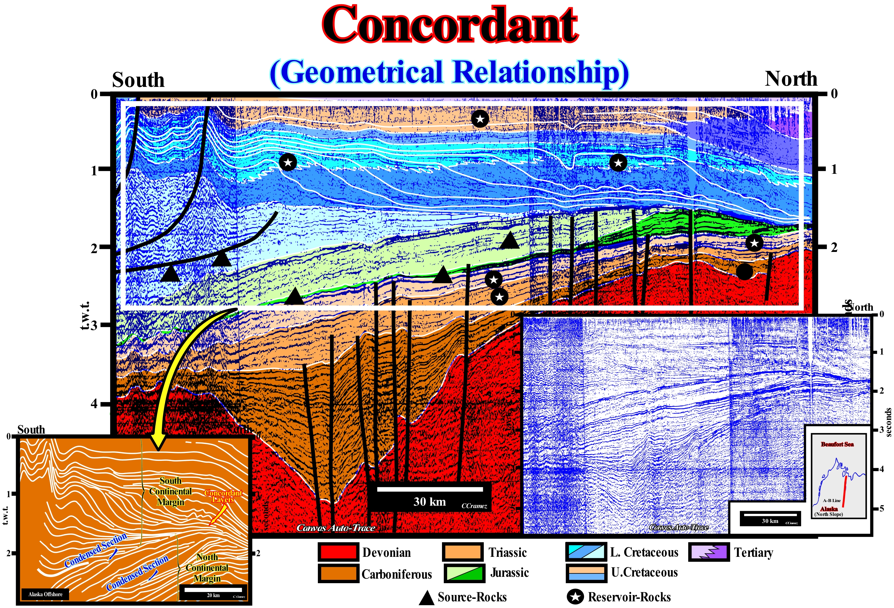
Goguel in his Treaty of Tectonic (1952) considered that from the structural point of view, it is common to contrast the tabular (sub-horizontal) regions with the folded regions. This distinction depends on the age of the layers observed in relation to the age of deformation. The layers after the deformation rest on the layers prior to deformation by an angular unconformities (tectonically enhanced unconformity) whose prominence is of fundamental importance. Grabau adopted the term "nonconformity" or "nonconcordant" for angular unconformities and the term "disconformity" to designate a rupture in sediment succession in which there is no apparent angular unconformity. The term non-conformity indicates a stratigraphic hiatus (lacuna), that for Grabau emphasizes an ingression. Orbigny used the terms "real unconformity" for angular unconformities and "isolation unconformity" for the stratigraphic hiatus between two concordant intervals, which can be observed on the Alaska offshore. This onshore corresponds to a mountain belt in the classification of the sedimentary basins of Bally and Snelson (1989), i.e., the result of the collision of the divergent continental margins of two lithospheric plates with the closure of the sea which between them. The collision term used here is a bit misleading. In fact, in Plate Tectonics the transformation of kinetic energy into "deformation" energy, such as when a car crashes into a wall, has no place. What really happens, is that due to the increase of the temperature and pressure of the sediments, these reach limit of resistance to the deformation and, therefore, are deformed. On this tentative geological interpretation of a Canvas auto-trace of a seismic line of the Alaska onshore, two downlap surfaces, more or less, concordant are visible under two progradational complexes with opposite vergence. These downlap surfaces, which are associated with the Post-Pangea continental encroachment cycle, suggest two opposite directions of terrigeneous influx. That means that each of them is associated with a divergent continental margin with opposite vergence. The lower downlap surface (Jurassic) is associated with a margin looking southward, while the upper one (Cenomanian/Turonian) is associated with a margin looking northward. The main unconformity between two divergent margins, which underlines the collision of two continental masses, is mainly defined by the toplaps of the upper interval and by the toplaps by no deposition or truncation of the top of the lower margin. It underlines the closure of the sea that existed between them. This unconformity is, locally, tectonically enhanced. The lower downlap surface (with a southward vergence) suggests a major continental mass, probably, a continent, existing in the North or Northeast. On the contrary, the upper progradation looking northward, suggest the presence of a continent southward. The continent, probably, corresponded to the west margin of the Interior Cretaceous Sea and the other to the eastern margin. In the most distal part of a downlap surface there is an almost a perfect concordance between the progradational and retrogradational reflectors, which on the seismic lines is translated by a, more or less, continuous reflector, that can be a sedimentary interval with potential marine source-rocks. According to the plate tectonics paradigm, such geometry translates the closure of a sea between the continental masses and the collision between them. In this particular case, the sea between the continental masses was the Cretaceous Interior Sea (Niobraran Sea or Inland Sea of North America). This sea was created when the plates of the Pacific and North America collided (Farallon plate subduction under the American plate during the Cretaceous), creating the Rocky Mountains to the West. As throughout the Cretaceous, the absolute sea level (sea level referenced to the Earth's centre) was high, the waters of the north (Arctic Ocean) and the south (Gulf of Mexico) were united in the lowlands of the continent, forming the Niobraran Sea* that grew and decreased along the Cretaceous. This large inland sea that existed during the Middle Cretaceous and Late period, as well as the Early Paleogene, divided the North American continent into two landmasses: (i) Laramidia to the west and (ii) Apalatian to the east. At its peak, this sea extended from the Rocky Mountains to the Appalachians (its width reached about 1,000 km for a length of 3,300 km) with a depth of 800 / 900 meters. At the end of the Cretaceous, the continuous uplift of land shrank the sea that in the long term withdrew completely.
(*) The first phase of the development of the Niobraran Sea began in the Middle Cretaceous, when the sea rose creating an arm of the Arctic Ocean that connected the West with North America, which created the Mowry Sea. In the south, the Gulf of Mexico, which was an extension of the Sea of Tethys, merged with the Mowry Sea during the late Cretaceous to completely form the inland sea of North America (Niobraran).
Condensation (Sedimentary).............................................................................................................................Condensation (Sédimentaire)
Condensação / Condensación (sedimentaria) / Kondensation (Sediment) / 缩合 / Конденсация (осадочная) / Condensazione /
Decreasing in the rate of accumulation of a deposit. Stratigraphic starvations may occur due to a lack of terrigeneous influx at the site of accumulation or when the terrigeneous influx, at a given site, is balanced in relation to the rate of displacement of deposits. When sediment accumulation rates are low, a large variety of, more or less, rare sedimentary deposits may form: (i) Bioturbated Horizon ; (ii) Anomalous Shell Accumulations; (iii) Authigenic Minerals (such as phosphate, pyrite, siderite, glauconite, etc.) ; (iv) Early Cementation ; (v) Hardgrounds, as well as (vi) Enriched Horizons in rare sedimentary components, such as volcanic ash, micrometeorites, etc.
See:« Downlap Surface »
&
« Starvation Interval »
&
« Transgressive Interval »
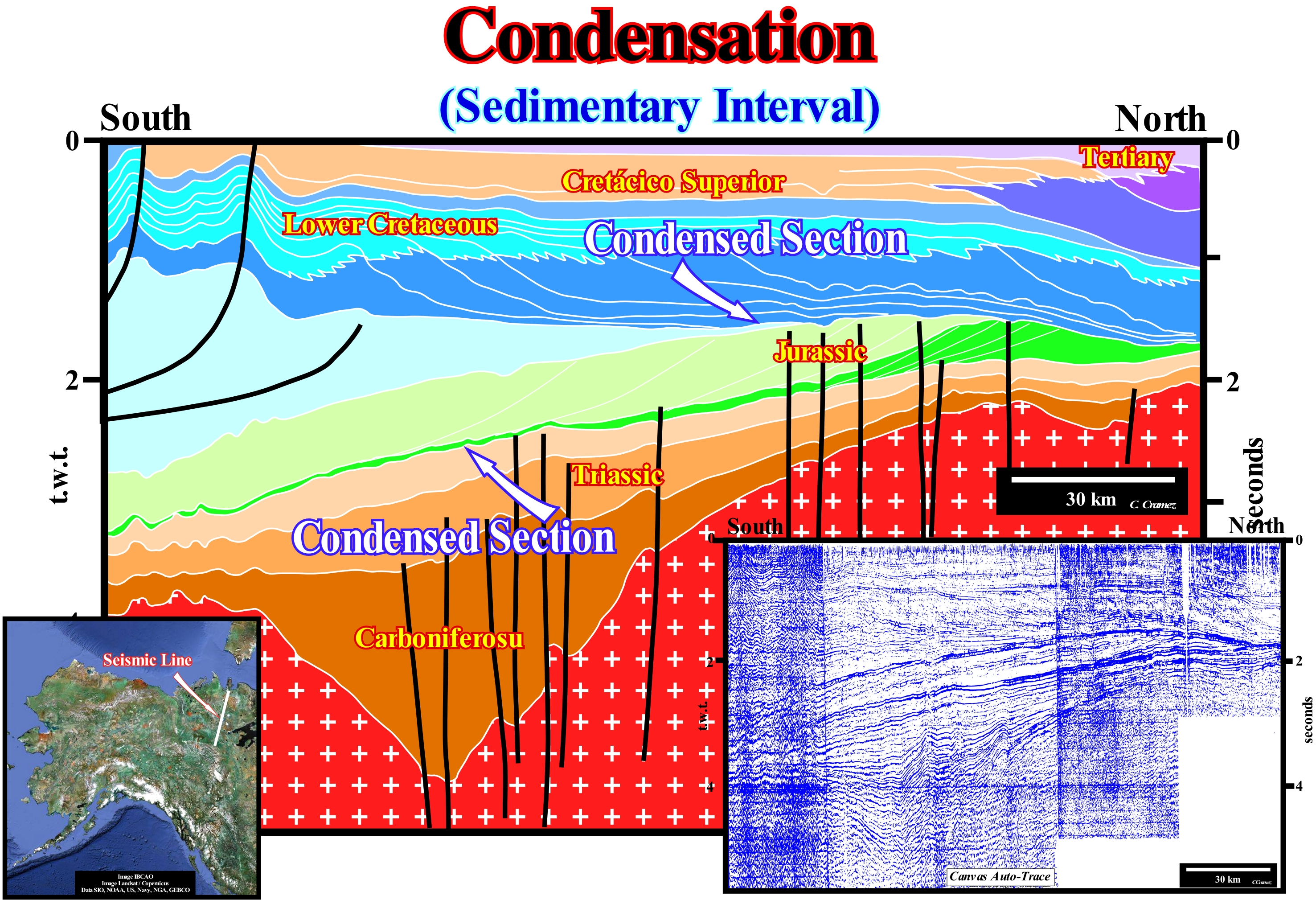
For Vail et al. (1984), a condensed section is a thin marine stratigraphic interval characterized by a very slow deposition rates (<1-10 mm / year). Within a sequence-cycle, a condensed stratigraphic section consists, generally, of hemipelagic and pelagic sediments, without autochthone materials, deposited on the platform (external/middle), on the continental slope and in the deep part of the basin, during the maximum acceleration of the relative sea level rise, in which the coastline upward displacement is maximum. As clastic sedimentation rates are deprived of continental margin sediments, skeletal remains of pelagic fauna accumulate, preferentially, to form condensed levels of fauna, which are often used as time-paleomarkers. Within a sequence-cycle, at the beginning of the transgressive interval (TI), the condensed sections accumulate in the basal and dipping portions of the continental slope. However, as the coastline moves landward, following increasingly important marine ingressions, condensed sections can, gradually, be deposited on the shelf as well. From the moment that the marine ingressions begin to decelerate, i.e., since a marine ingression is smaller than the previous one (beginning of deposition of the highstand prograding wedge), the diachronic surface emphasizing the top of the transgressive interval begins to to be fossilized by the highstand prograding wedge (HPW). As the condensed stratigraphic sections are rich in organic matter and deposit in, more or less, anoxic sedimentary environments, when fossilized they constitute magnificent potential marine source-rock, as is the case in the onshore of Alaska illustrated in this figure. This onshore, geologically, corresponds to a mountain belt of the classification of the sedimentary basins of Bally and Snelson (1980). It is the result of the collision of the divergent continental margins and the closing of the Niobraran Sea that existed between them. The term collision here is a bit misleading. In Plate Tectonics, the kinetic energy of geological bodies (not of the atoms) does not play a significant role. The transformation of kinetic energy into "deformation" energy, such as when a car strikes a wall, does not exist in plate tectonics. What happens in reality is that the rocks of the lithospheric plates when subjected to high temperatures (increase of the kinetic energy of the atomic particle) and pressures, lose resistance to deformation and, therefore, they deform easily. On this tentative geological interpretation of a Canvas auto-trace of a regional seismic line of this onshore, two sedimentary condensation surfaces are easily recognized. Each of them is associated with downlap surface with opposite vergences. These condensed surfaces are very important in oil exploration. They indicate the most likely position of the marine source-rocks. The progradations, which here correspond to continental slopes, associated with these downlap surfaces testify to the closure of the sea that existed between the two divergent continental margins. This sea is probably the Cretaceous Inland Sea or Niobraran Sea, which existed during the Middle /Late Cretaceous to Early Paleogene and which divided the North American continent into two large land masses: (i) The Rocky Mountains to the West and (ii) the Appalachians to the East. The Niobraran Sea, which is a consequence of the Farallon plate subduction under the American plate, during the Cretaceous, stretched from the Gulf of Mexico to the Arctic Ocean. The lower progradations (within the green colored intervals), which are mostly oblique (aggradation is negligible) and probably of Triassic / Jurassic age. They correspond to the old continental slope of the landmass (continent) that was located northward. The higher progradations, between 1 and 2 seconds (t.w.t.) are, in particular, sigmoids (aggradation is significant) and probably of Cretaceous age. They correspond to the continental slope of the former continent located to the southward. The Prudhoe Bay oil field (Alaska / USA) is located in the paleohigh visible in the northern part of this tentative, which was fed by the hydrocarbons generated by the organic matter of source-rocks deposited deposited in association with the formation of the two condensed surfaces visible in this tentative interpretation (see also previous figure).
Condensed Section..........................................................................................................Section stratigraphique condensée
Secção estratigráfica condensada / Sección estratigráfica condensada / Kondensierte stratigraphischen Abschnitt / 致密地层剖面 / Сжатый стратиграфический разрез / Sezione stratigrafica condensata /
Marine stratigraphic interval, generally, not very thick, characterized by a very low sedimentation rate, between 1/10 mm per 1,000 years. A condensed stratigraphic section is composed of hemipelagic and pelagic sediments (almost without terrigeneous influence). A condensed sections is developed in the distal part of the shelf, slope or abyssal plain, during highstand periods and maximum continentward displacement of the shoreline. A condensed stratigraphic section can be recognized by the abundance of pelagic fossils, authigenic minerals and hardgrounds.
See : « Transgressive Interval »
&
« Transgression »
&
« Retrogradation »
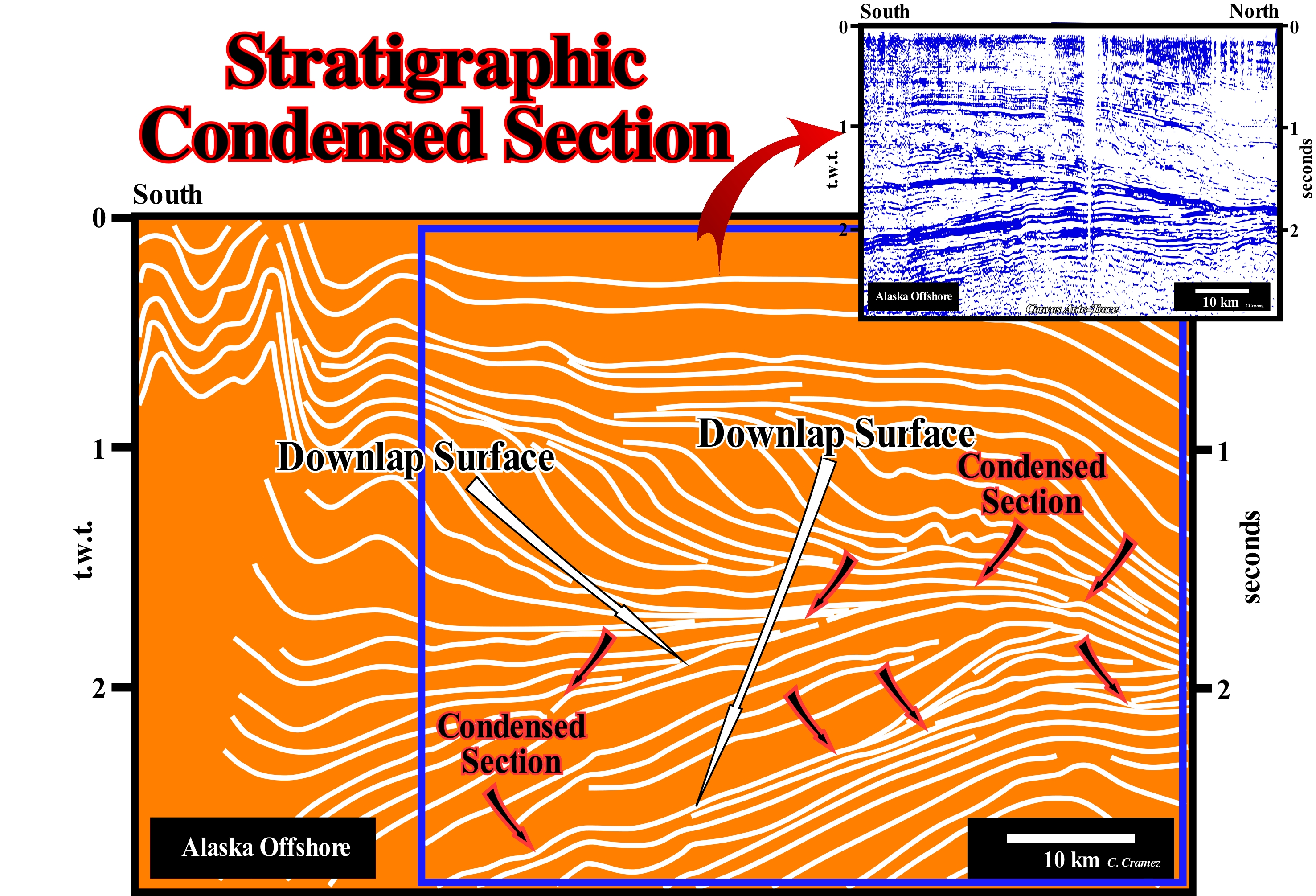
On this tentative geological interpretation of a Canvas auto-trace of a regional seismic line of Northern Alaska, downlaps, with opposite slopes, create two major downlap surfaces and two associated condensed stratigraphic sections. This geometry, characterized by two large progradational intervals with opposite vergences, underlines the closure of an ocean due to a collision between the two divergent continental margins. Attention to the term collision, which in the current language means the transformation of kinetic energy into energy of deformation, like when a car crashes against a wall. However, in Pate Tectonics, the kinetic energy plays no role. The rocks are deformed when they lose their resistance to deformation, usually by increasing temperature and pressure. The lower downlap surface, along which the downlaps are oriented southward, and the condensed stratigraphic section, which is the fossilized by the progradations, suggest the presence of a continent northward and an ocean southward. On the contrary, the upper downlap surface and the associated condensed section, which are fossilized by the progradtions with a northward vergence North, suggest the presence of a continent southward and an ocean northward. This ocean was probably the Niobraran Sea (Interior Sea of North America) that existed between the Middle and Late Cretaceous (Early Paleogene to certain geoscientists). It divided the North America continent into two great continental masses: (i) Laramidia to the West and Appalachia to the East. Laramidia was an island continent that existed during the Late Cretaceous (more or less between 99 Ma and 65 Ma), when the Niobraran Sea divided the North American continent into two. During the Mesozoic, Laramidia was a large island separated from the Appalachia by the Niobraran Sea, which later sub-divided into two sectors (North and South) and then retired to the south (Gulf of Mexico) and to the north (Hudson Bay), while the continental masses came together to form the North American continent. The Appalachia is the name given to the Appalachian Mountains during the Mesozoic (between about 252 Ma and 66 Ma), which formed an island separated from Laramidia in the West by the Niobraran Sea. This ancient sea that was more than 750 m deep and more than 900 km long, extended between the Arctic Ocean and the Gulf of Mexico through what is now the United States and Canada. The substrate of most of the ocean between these two continental margins consisted of old oceanic crust and the presence of an mid oceanic ridge was plausible. Over time, the oldest oceanic crust (close to the continents) became so dense that, by contrast of density with the continental crust, subdued under one of the continents creating an abyssal trench and a B-type subduction zone (Benioff). As the rate of subduction of the oceanic crust was much greater than the rate of formation of new oceanic crust, in the mid oceanic ridge, the ocean began, progressively, to close as the margins approached. In a first phase, the mid-oceanic ridge* was swallowed up by the subduction zone, which accelerated the closure of the ocean. In the final phase, the margins came into contact completely closing the ocean, which created visible geometry in this tentative interpretation. The closures of the Rheic Sea** (created a zone of suture of more than 10,000 km, that goes from Mexico to Turkey and that contributed to the formation of the Pangea supercontinent) and the Iapetus Sea***, are well known examples, that , as shown above, can be brought out by the stacking of significant condensed stratigraphic sections.
(*) Submerged mountain ranges that resulted from the slow removal of tectonic plates with an average height of 2,000 to 3,000 meters above the surrounding oceanic bottoms and which has axial groove running longitudinally the dorsal, along which emitted the new oceanic crust arising from the magma rise of the sublithospheric mantle.
(**) Sea between the small supercontinent Gondwana and the Laurentia continent in the Early Cambrian created a zone of suture of more than 10,000 km, that goes from Mexico to Turkey and that contributed to the formation of the Pangea supercontinent .
(***) Sea between the continents Laurence, Baltic and Avalonia, which disappeared with the Acadian, Caledonian and Taconic orogenesis, when these three continents joined together to form a large continental mass called the small supercontinent Euramerica.
Cone Alluvial (Fan delta entering in the sea)..............Cône ou Éventail alluvial (aboutissant dans un plan d’eau)
Leque aluvial / Abanico aluvial (que termina en el mar o lago), Abanico aluvial / Schwemmkegel (zum Meer, See) / 扇三角洲 / Аллювиальный конус выноса / Conoide alluvionale (che porta al mare, lago) /
Fan delta* deposited, directly, into the sea (when the shoreline is situated near the bay.line), which forms progradational geological bodies that certain geoscientists call alluvial-type deltas. Synonym for type-Gilbert Delta.
See: « Fan Delta »
(*) A fan delta is a depositional feature formed where an alluvial fan develops, directly, in a body of standing water from some adjacent highland.