
Littoral (Shore).................................................................................................................................................................................................................................Littoral
Litoral / Litoral / Küstengebiet / 滨海 / Прибрежный / Litorale /
Range of the continent that is in contact with the sea or with phenomena characteristic of that area.
See: « Inter-tidal Beach (between tides) »
&
« Fair Weather Wave Base »
&
« Shoreline »
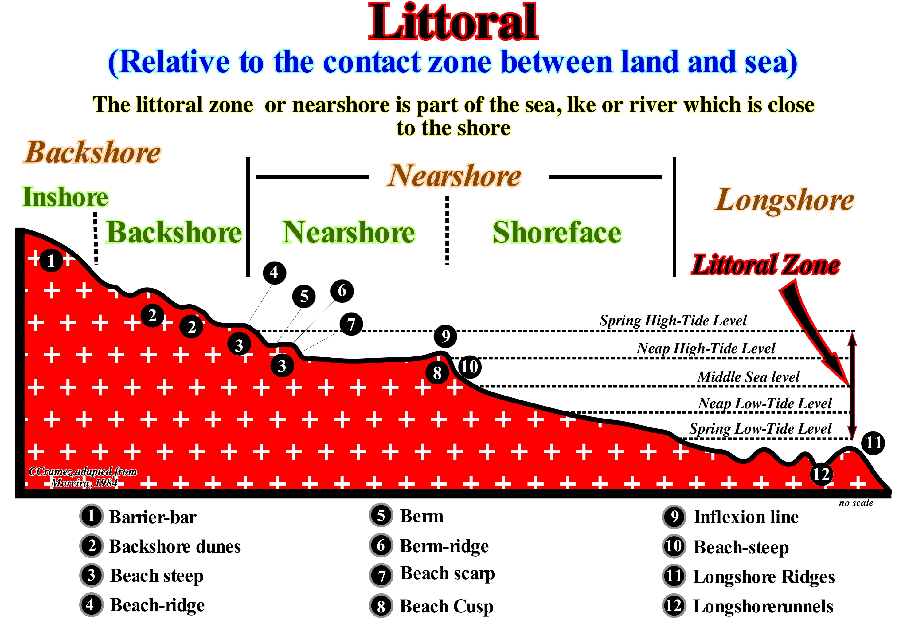
As illustrated in this sketch, some geoscientists restrict the littoral to the intertidal range. Others extend it to the interior, by a space whose limits are not, always, easy to define and, also, seaward to the surf wave line. Other consider the littoral synonym of the coastline, i.e., the strip of land that separates the area between a maritime area and the mainland, or the hinterland. Based on the distribution of the coastal biocenoses (balanced relation of the living beings with the natural environment), depending on the times of emersion, the littoral (coastline) can be divided into bands or zones, parallel to the shoreline: (i) Supralittoral ; (ii) Mesolittoral and (iii) Infralittoral. The supralittoral zone comprises the space reached directly by the sea-spray above the spring high-tides level (always emerged), and which, in turn, can be sub-divided into: (a) Upper, which is the part struck only by small bubbles of air with crystals saline and (b) Lower, which is the part reached by the sea-spray and directly by the foam of the surf in the high-tide. The meso-littoral zone, which corresponds to the intertidal range, can also be sub-divided into: (a) Upper, which is the area between the middle sea level and the spring high-tide level, and (b) Lower, which is the part between middle sea level and the spring low-tide level. The infra-littoral zone, which is below the spring low-tide levels (always immersed), can be sub-divided into: (a) Upper, i.e., the part between the spring low-tide levels and the breaking zone and (b) Lower, i.e., the part that corresponds to the strip of surf (Moreira, 1984). It should be remembered that the tides are oscillation waves of low amplitude (few meters), great wave-length (several hundred kilometers) and a very large period (30-300 seconds). They are formed in the high sea due to the attraction of the Moon and Sun over sea-water. Along the coast, these waves change and are extended by waves of translation that give rise to the tidal currents : (1) Flood (High-tide, Rising tide, Flow), that goes towards the coast and causes an accumulation of water whose maximum is called high-tide and (2) Ebb or Falling tide, which is directed seaward, draining the water accumulated along the coast during the high-tide, and whose lowest level is the low-tide. When the Sun and Moon are in conjunction or opposition the tides are spring tides (with great amplitude). When the Moon is in waning or crescent (quadratures), the tide is neap tide, that is with minimum amplitudes.
Littoral Current (Longshore drift, offshore drift)...........................................................Courant de dérive littorale
Corrente de deriva litoral (longitudinal) / Corriente de deriva del largo / Litoralströmung / 沿岸漂, 陆上漂移 / Дрейфовое прибрежное течение / Longshore deriva, Corrente littorale /
Mass of water moving along the coast, outside the breaking range, from the accumulation of the waters of the uprush and backrush currents, when the surf is oblique to the shore. It has an important morphogenic action, due to its transport capacity. This current is sometimes also called Zigzag Current or Beach Drift Current or Coastal Current.
See: « Stream »
&
« Beach Drifting »
&
« Swash Currents »
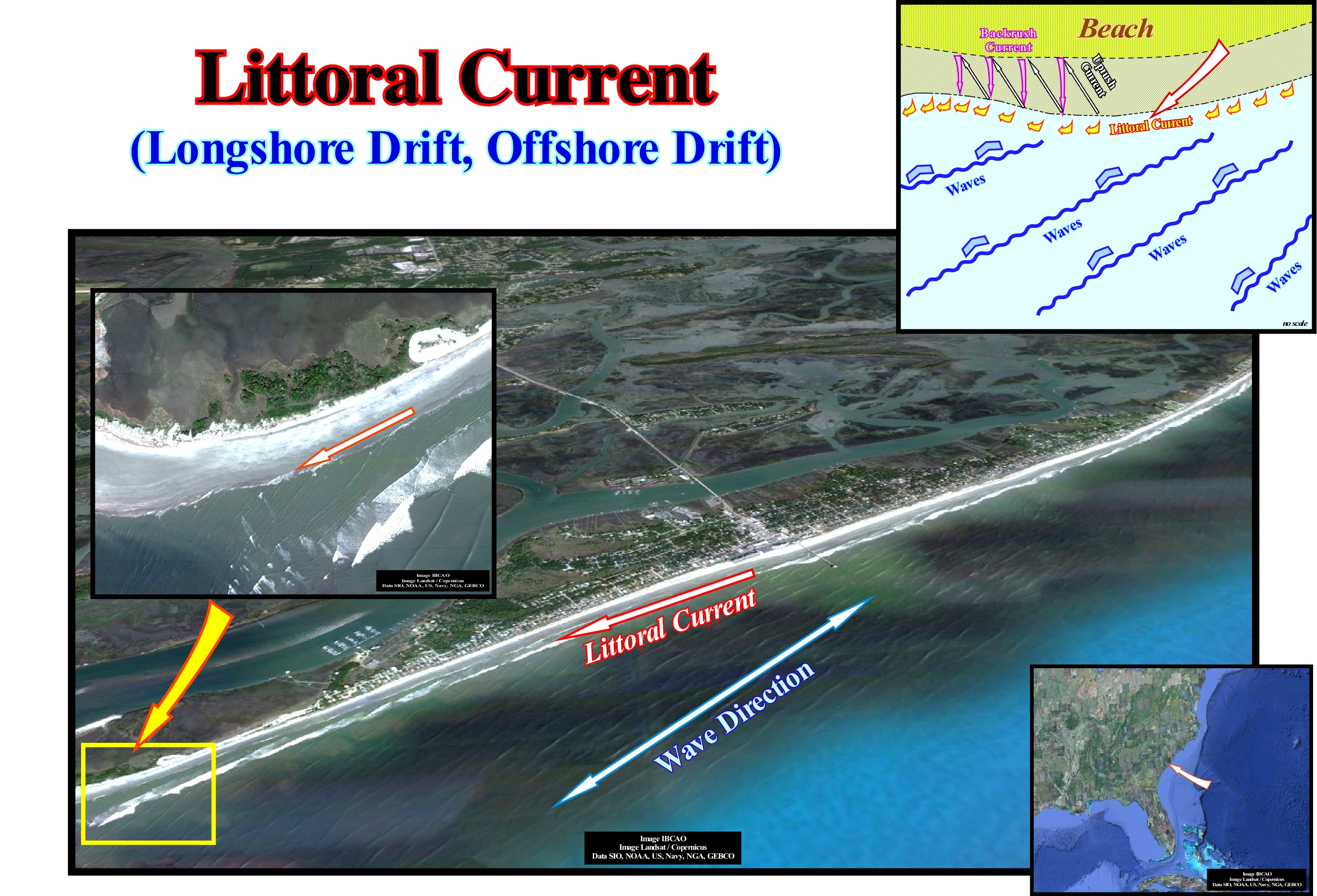
Under the circumstances, marine currents can build or destroy the coast. Two main types of currents model the beaches: (i) Backwash current and (ii) Littoral current (longshore or onshore drift). Backwash or backrush currents form when the sea-waves are, roughly, perpendicular to the shoreline. The water hits the coastline and has to escape to anywhere. It tends to flow through narrow streams off the beach (often by rip currents). These currents, sometimes called rip currents can be extremely dangerous. They move perpendicularly to the beaches toward the sea. They can be very strong, but they are relatively narrow (one or two tens of meters). They can carry, seaward, large quantities of sand offshore. If you are in the middle of one of these currents, proceed as follows: (a) Remain calm and conserve your energy ; (b) Do not try to fight the current ; (c) Swim parallel to the coast line (as stated above they, rarely, reach a width of 10 meters) and when you are out of the stream swim in the direction of the coast ; (d) If you are not able to swim out of the stream, allow yourself to float or swim in the direction of the stream until you leave it (this type of sea currents are, rarely, more than 100 m long), and then swim calmly to the shoreline. As illustrated in this sketch, a littoral or coastal drift forms when the sea-waves are obliques to the shoreline and therefore, they form stretched beaches and, more or less, rectilinear, since they carry the sand along the coast and deposit it in less mobile areas. It is these currents that deposit the sand against the beach spurs on the side where they oppose the direction of the current.
Littoral Plain (Coastal plain)............................................................................................................................Plaine côtière (Plaine littorale)
Planície litoral / Planicie litoral (costera) / Litoralebene, Küstenebene / 沿海平原 / Прибрежная равнина / Pianura costiera /
Flat continental surface or very low slope, low (altitude less than 200 meters, for certain geoscientists), of sedimentary origin, with a coastal position.
See: « Coastal Plain »
Littoral Pothole..............................................................................................................................................................Mare, Marmite littorale
Marmita litoral (ouriçanga) / Marmita costera / Schlagloch / 在地质 / Котловина / Pothole /
Pothole formed by dissolution that is found in the bottom of the solution benches or between the coastal clints. They have a more or less cylindrical shape, with a smooth bottom and, in general, with a deposit of sand, pebbles and shells. The walls are smooth and often covered by living beings characteristic of the infratidal floor (Moreira, 1984). Synonym with Waterpockets.
See: « Erosion »
&
« Kettle »
&
« Pothole »
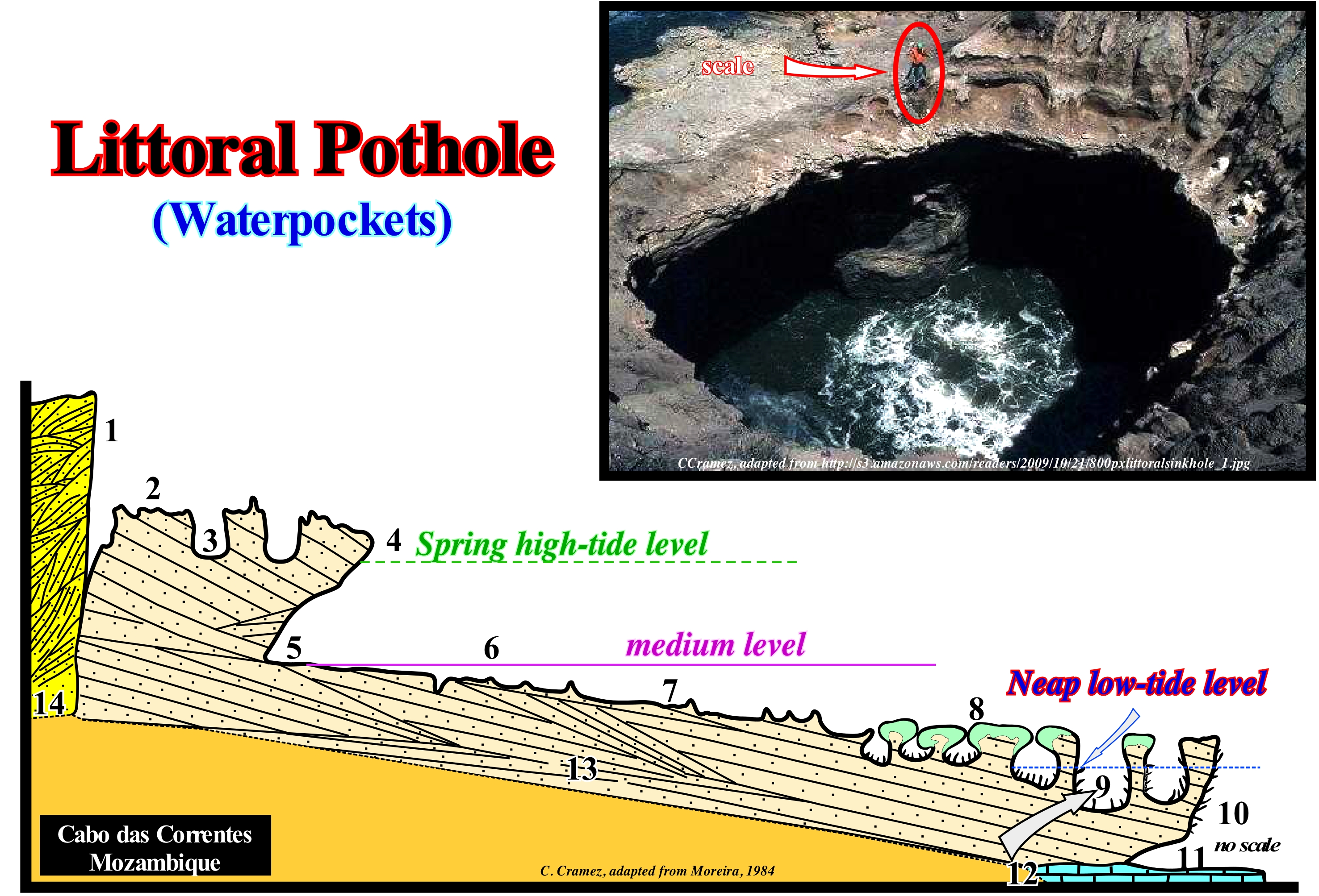
In certain Central American islands, the broader forms of the littoral potholes are called water-pockets. As illustrated in this sketch, the geometry of the littoral potholes suggests a mechanical, swirling reinforcement similar to that produced by the giant kettles and drilling kettles. Littoral potholes may have a border or not, which may be elliptical or even lobed, when the water-pockets result from the coalescence of simple forms. Sometimes they retain, among them, remains of the coalescing walls, made up of rocky septa. The depth of the littoral potholes varies between 5-6 and 10 meters, being the deepest ones in the lower part of the strand. The dissolution processes are, essentially, biochemical and each water-pocket corresponds to an ecological niche. The geological section of the Cabo das Correntes (Mozambique), illustrated above, shows a characteristic zoneography of the main types of micro-forms of the coastal karst in aeolianites and sandstones. From the mainland to the sea, the following micro-forms are recognized: (1) Alveolized dead cliff ; (2) Platform with pointed littoral clints; (3) Upper littoral potholes, i.e., located above the spring high-tide level ; (4) Visor cliff ; (5) Undercut (notch, groove) ; (6) Platform with solution benches and embryonic water-pockets (below middle sea level) ; (7) Platform with solution benches encrusted by calcareous algae ; (8) Tubicolous bioconstructed platform (above spring low-tide level) ; (9) Lower littoral potholes, more or less, located at the spring low-tide level ; (10) Overhanging surface cornice due to wave surfing ; (11) Submerged undercut (notch, groove) ; (12) Dead coral reef. Sandstones (13) and aeolianites (14) are the rocks that make up this coast. The levels of high-tide and low-tide, which correspond to the tides during the syzygies (full moon and novilunium), are characterized by large amplitudes. The equinoctial tides, which occur on the equinoxes, have maximum amplitudes.
Littoral System (Depositional)................................................................................................................................................Système littoral
Sistema litoral (deposição) / Sistema litoral (depositación) / Litoralen System / 滨海系统 / Прибрежная система / Sistema di Litorale /
Depositional System between the dunes and the depositional coastal break. It is one of several non-marine deposition systems: (i) Low Fluvial Systems ; (ii) Wind Systems ; (iii) Delta Systems (certain parts) ; (iv) Coastal Systems (barrier bars) ; (v) Beach Systems (certain systems). As all these depositional systems are located near the coastline, they are directly influenced by relative sea level changes, which are the main factor of the cyclicity of the paralic deposits.
See: « Coastal Non-Marine Deposit »
Loam (Mud).......................................................................................................................................................................................................................................................Boue
Lama / Lodo / Kot, Schlamm / 泥 / Буровой раствор / Fango /
Mixture of clay and / or sludge and water. The coastal mud is often called mudflat (soft or hard).
See : « Clay »
&
« Shale »
&
« Ooze »
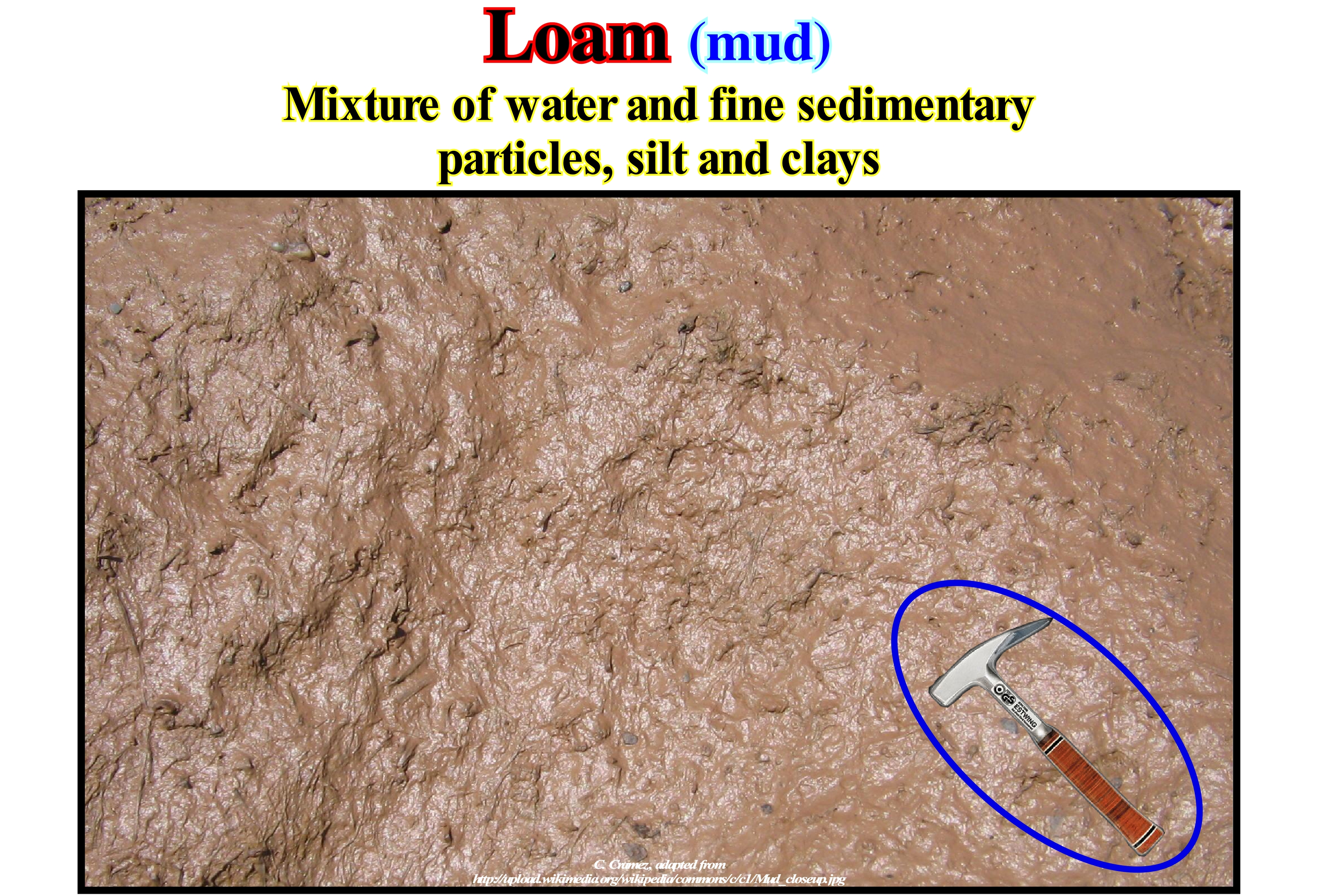
The term loam, for many geoscientists, is synonymous with mud, slime or clay. The muddy bottom of the rivers, lakes or sea, as well as, the deep pelagic mud of the oceans, which is formed of skeletal remains of floating microscopic organisms (<30 percent) is considered a loam. Certain types of mud, such as the pelagic clay, are formed, mainly, in the furthest areas of the continent, so that the slow but continuous deposition of dead micro-organisms is not obscured by the sedimentary particles coming from the continent. These muds and slimes are normally sub-divided into: (i) Limestone Muds, when containing calcium carbonate skeletons and (ii) Siliceous Muds, when they contain skeletons formed of silica. They can also be sub-divided according to the predominant type of skeleton. The term mud is currently used to designate sewage sludge (municipal or industrial), i.e., products used in effluent treatment plants. These muddy sedimentary particles consist mainly of dead bacteria and mineralized organic matter. A treatment plant produces, on average, more than 40 g of dry matter per day per inhabitant. There are different types of sludge purification function of the treatments used to purify the water: (A) Primary Purification Sludge - are deposits recovered by simple decanting of waste water, which has high concentrations of mineral salts but also organic matter ; (B) Physico-Chemical Purification Sludge - resembles primary sludge, except that a reagent (salts of iron, aluminum and other flocculates) is added during the treatment of waste water to agglomerate fine particles and improve sedimentation ; (C) Biological Purification Sludge, also called secondary sludge, which comes from biological purification (activated sludge, biological disks, bacterial beds, etc.) are poor in concentration (± 10 g / l) and very organic, because they consist, mainly, of bacterial bodies and their secretions ; (D) Mixed Purification Sludge - consisting of a mixture of primary and organic sludge from most treatment plants ; (E) Prolonged Aeration Purification Sludge without primary settling obtained with highly ventilated pollutants (these sludge are very concentrated, less organic and less hazardous).
Lobated Delta..................................................................................................................................................................................................................Delta lobé
Delta lobado / Delta lobado / gelappt Delta / 叶状三角洲 / Лопастная дельта / Delta lobate /
When the deltaic plain has a convex geometry towards the sea. This type of delta can be mono or multi-lobate.
See :« Delta »
&
« Bottomset Bed (delta) »
&
" Closed Delta »
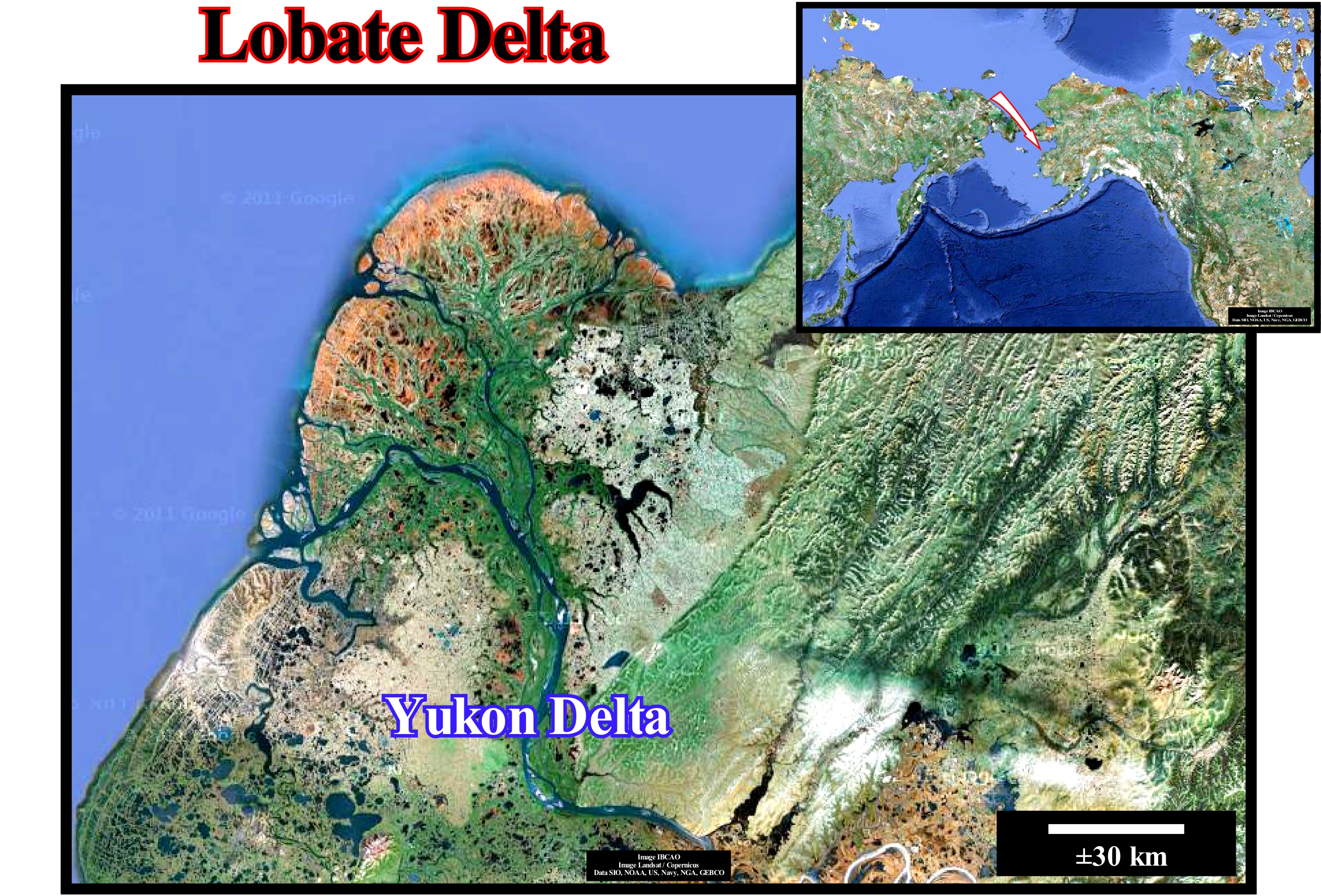
Taking into account the dominant forces in the formation process, geoscientists, such as Galloway, classified the deltas into three main types: (i) River-Dominated ; (ii) Wavy-Dominated and (iii) Tidal Dominated. The river-dominated deltas are those dominated by the terrigeneous influx of rivers. The wavy-dominated deltas are dominated by the activity of the sea-waves. The tidal-dominated are those where by tidal activity and tidal-currents are predominant. The river-dominated deltas are cut and have many distributaries with marshes, bays or tidal flats in the inter-distributary regions. They occur when the water-course and sedimentary particles transport are strong and other effects, such as rework by waves or tides, are smaller. These deltas tend to form large delta lobes in the sea, which may have little more than the distributary channel and have a natural marginal dykes (levees) exposed above sea level. Due to their resemblance to a bird's foot, they are, often, referred to in the geological literature as a "bird's foot delta", as is the case of the Mississippi River Delta Building*. When much of the floodplain between the distributary channels is exposed above sea level, the delta displays a lobate form. Wave-dominated deltas are more regular, exhibiting curved and arched shapes with frequent beach ridges, such as in the Nile delta or Niger delta buildings. In these deltas, the surf of the waves causes a mixture of fresh and salt water so that the flow, immediately, loses its energy and deposits all its load along the coast. Tidal-dominated deltas occur in areas with high tides or with high velocity tidal currents. Such deltas, often, resemble to an estuarine bay filled with many elongated islands parallel to the main tidal stream and perpendicular to the shoreline, such as the Brahmaputra Delta or the Mahakam Delta buildings. The deltas of the Mississippi River and those of the Yukon River are typical deltas dominated by the terrigeneous influx carried by the rivers. The deltas associated with the Senegal and San Francisco (Brazil) rivers are dominated mainly by the activities of the sea-waves, while the deltas associated with Fly river (Papua New Guinea) are dominated by the tidal action and tidal currents. The deltas dominated by the influence of the rivers may have an elongated or lobular geometry. Lobated deltas, such as those of the Yukon delta building, have, generally, many distributive (current flowing out of the main channel of the river), some of which may be inactive for some time. The bays between the distributives are very small or may not even exist. On the contrary, marshes and peat bogs (peat deposits, which are the fuel formed by vegetable matter, more or less, carbonized) almost always exist between the channels. The sand is deposited at the mouth of the distributives, around the delta front, which creates a, more or less, continuous planar sandy body, which, downstream, passes to a silty barrier bar and then to prodelta shales. The progradation (seaward displacement or outbuilding and, generally, upward (upbuilding), i.e., with aggradation) of the coastal onlaps of a lobate delta is, relatively, slow. This type of delta was, predominantly, in the former Mississippi Delta, with fairly thick (20/30 m) sandy delta fronts. After a period, more or less, long of growth, the main current of the Mississippi, it turned aside, laterally, and created another lobed delta. This pendulum effect allowed the formation of several delta lobes up to about 1,500 years BC when the modern delta on bird's paw began to form. The development and, above all, the enormous thickness of the modern Mississippi Delta Building was possible due to the strong subsidence created by compaction of the sediments (reduction of volume or thickness of sediments, usually of fine grain, due to the increase of the sedimentary load or the tectonic pressures), which has caused, several times, the flood of the delta by the marine waters. A great number of coarsening upward sedimentary intervals were formed by the successive growth and abandonment of the lobate deltas. This photograph illustrates the lobate geometry of the modern Yukon Delta (Alaska), which is one of the largest deltas in the world. It developed where the Yukon and Kuskokwima rivers (or Kusko, south of the Yukon) discharge into the frigid Bering Sea on the western coast of the state of Alaska. With about 129,500 km2 in size, the Yukon Delta is one of the largest deltas in the world. It is larger than the modern Mississippi Delta and comparable in size to the entire state of Louisiana in the United States. The geometry of the delta suggests the influence of the terrigeneous contribution of the river is predominant, although the Arctic climate plays an important role in the construction and lobular geometry of the delta. Other types of delta that can be considered, as a function of delta dynamics and the shape of the lowland surface, are: (i) Abandoned Delta or Sub-delta ; (ii) Alluvial delta ; (iii) Arctic Delta; (iv) Rounded Delta; (v) Atrophied Delta; (vi) Complex or Polymorphic Delta ; (vii) Cuspate Delta ; (viii) Finger Delta ; (ix) Flood delta ; (x) Closed Delta ; (xi) Gilbert type Delta ; (xii) Lava Delta ; (xiii) Rising-Tide Delta ; (xiv) Tidal Delta ; (xv) Submarine Delta ; (xvi) Storm Delta ; (xvii) Wave Delta ; (xviii) Ebb Delta.
(*) A delta building is a, more or less, vertical stacking of several deltas. A delta is a sedimentary systems tract composed, mainly, by three depositional systems (lithological unit with an associated fauna) : (i) Deltaic plain, (ii) Delta front and (iii) Prodelta.
Loess......................................................................................................................................................................................................................................................................Loess
Loess (limo) / Loess (limo) / Löss / 黃土 / Лёсс / Löss /
Wind sediment formed by the accumulation of silt carried by the wind and, to a lesser extent, by variable fractions of sand and clay.
See : « Clay »
&
« Sand »
&
« Silte »
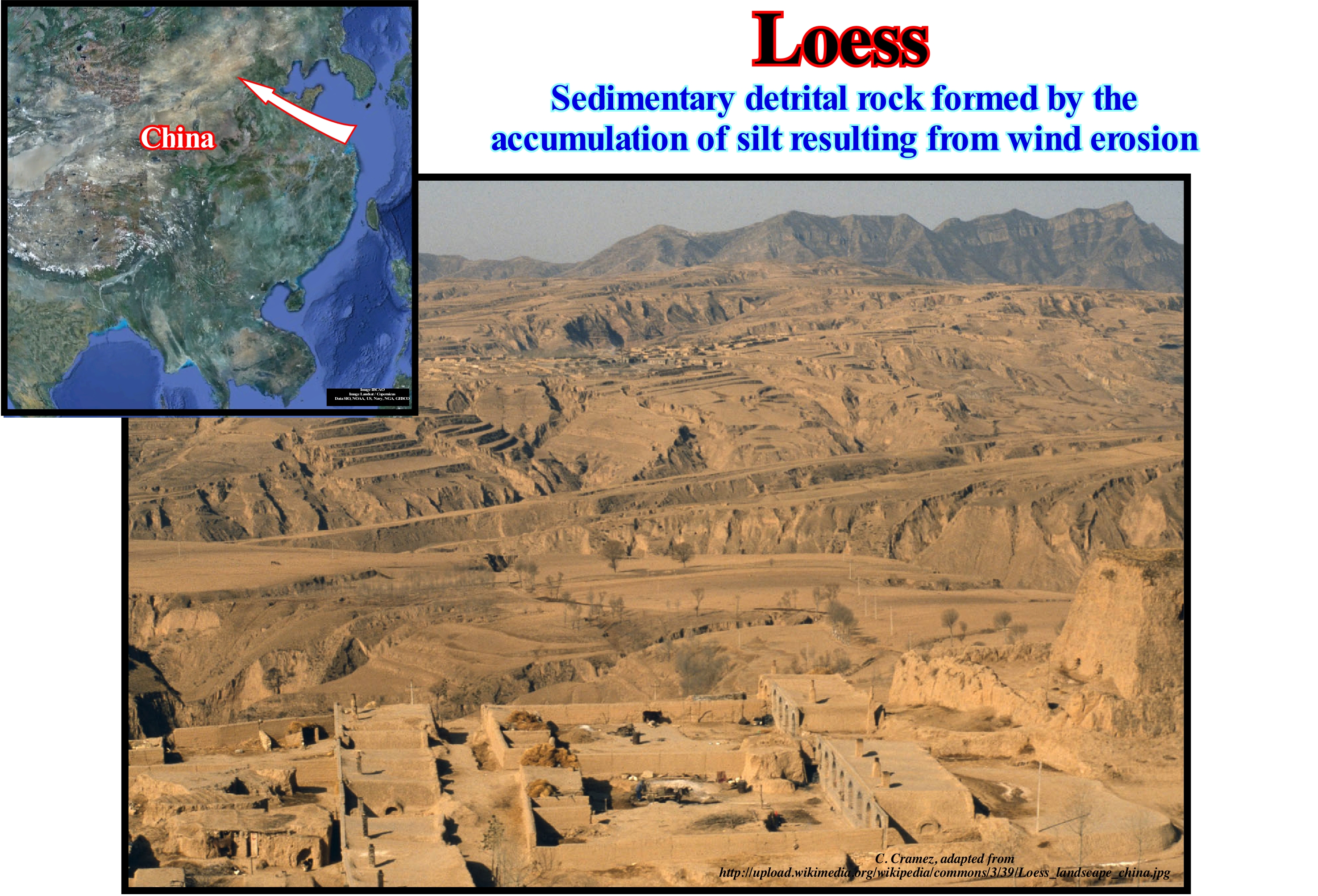
Loess (from the German Löss, loose) is a fertile soil of yellow coloration, formed by sediments deposited by the wind. The loess is found in part of Europe (France and Netherlands) and mainly in China, especially, along the Yellow River, where it is, widely, used for rice cultivation. The definition of loess is twofold: (i) Lithological (calcareous silt) and (ii) Genetic (wind deposit). The loess is, mainly, formed of silica (detrital quartz) and calcium carbonate (CaCO3), but it contains, to a lesser extent, feldspar, biotite (two minerals that, with the quartz, enter in the sand composition) and clays, often kaolinite (these clays can be agglomerated and form fine silt grains). In terms of its structure, the loess is characterized by a good grain size calibration due to its wind origin, with grains between 10 and 50 micrometers (a size between 2 and 50 microns, which corresponds to what certain geoscientists call slime). The loess is homogeneous, without stratification, but has a very high porosity resulting from the traces of roots and a carbonated cementation of the grains. During the Pleistocene, the loess is the result of soil accumulation under cold and dry conditions of wind-blown silts from the source zones (alluviums, outwash or fluvio-glacial deposits, coastal and estuarine sediments, arid zones, etc.) subjected to wind deflation. A grain size drift (sandy loess) may be due to the proximity of the loess area of origin and thus due to less advanced wind screening. In Belgium, an area of "sandy loess" separates the wind sands of the Campine sands from the Hesbaye loess. A grosser granulometry may also be due to an enrichment of available local materials in abundance. As shown in this figure, when loess formations are plentiful, they tend to create a specific morphology, either because of their deposition (poorly marked topography of small hills and disorganized river network) or because of their sensitivity to erosion (plateaus Chinese loess, lands, etc.) (http://fr.wikipedia.org/wiki/Loess).
Log Patterns (Turbidites).............................................................................................Morphologie des diagraphies (Turbidites)
Morfiologia das diagrafias / Morfología de perfiles (diagrafías, turbiditas) / Morphologie der Stämme (Turbiditen) / 侧景区线形态(浊流沉积)/ Морфология каротажных схем / Morfologia dei log (torbiditi) /
In the electrical logs, the different types of turbidite deposits have a, more or less, typical signature. Recall that the lowstand systems tract (LST) is composed of three sub-groups. From bottom to top, it is recognized: (i) Submarine Basin Floor Fan (SBFF) ; (ii) Submarine Slope Fan (SSF) and (iii) Lowstand prograding wedge (LPW). In each of these subgroups, reservoir-rocks, usually of sandy facies, either in the form of lobes or in the form of channel fills or elongated depressions between the turbiditic levees can be developed. The morphologies of spontaneous potential (PS) and Gamma Ray (RG) logs are the most characteristic. It can be said the gamma ray log of the basin floor fans (BFF) are, generally, cylindrical in shape and that the lower and upper limits are abrupt. The lower limit corresponds to an unconformity (erosional surface) and the upper limit to a downlap surface (with opposite vergence) of the base of submarine slope fans. The contourite morphology log is similar to that of the submarine basin floor fans (SBFF), since the internal configuration is parallel and the dip of the contourites has no influence on the logs. The morphology of the submarine slope fans (SSF) is characterized by a succession of increasing and decreasing morphologies, which are typical overbank deposits (turbidite levees) and depressions between them (sometimes channels when there is erosion). The lower limit may correspond to an unconformity (in the absence of submarine basin floor fans), but the upper limit corresponds, almost always, to a downlap surface associated with the progradations of the lowstand prograding wedge. Finally, the morphology of the shingled turbidites corresponds to a vertical succession of cylindrical morphologies, like the submarine basin floor fans.
See: « Slope Deposit »
&
« Turbidite »
&
« Marker Bed »
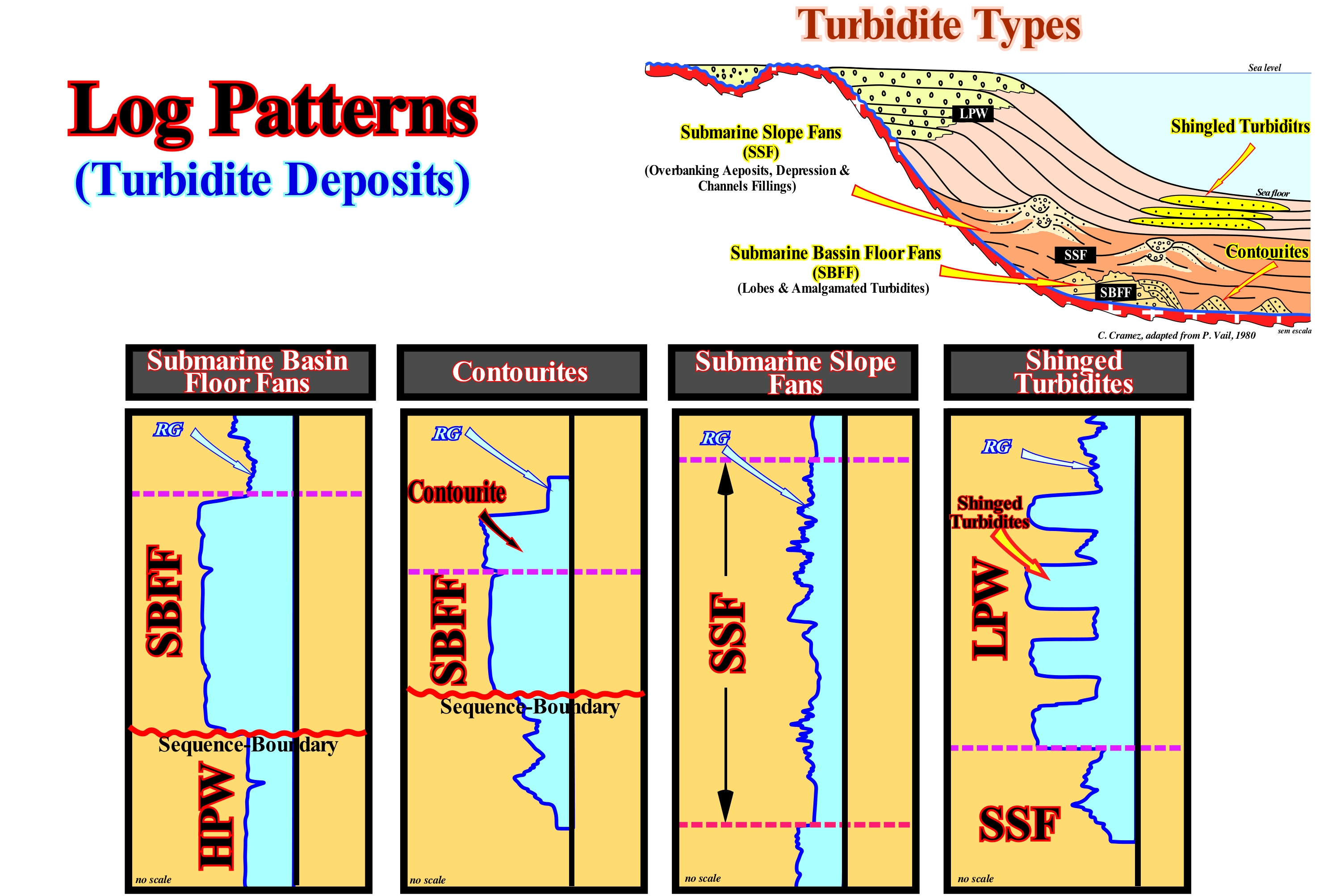
In this sketch, the most frequent morphologies of the gamma ray (RG) log of the main turbidite deposits of the lowstand systems tracts group group (LSTG), that is to say, of the (i) Submarine Basin Floor Fans (SBFF) ; (ii) Submarine Slope Fans (SSF) and (iii) Submarine fans cones associated with the lowstand prograding wedge ( LPW), i.e., "shingled turbidites". As shown in this figure, the lowstand systems tracts group (LSTG) of a sequence-cycle, when complete, is composed of three sedimentary systems tracts subgroups, which from bottom to top, are: A) Submarine basin floor fans (SBFF), sometimes with associated contourites* ; B) Submarine slope fans (SSF), with their characteristic "gull-wings" structures and (iii) Lowstand prograding wedge (LPW), sometimes, with shingled turbidites associated. In each of these subgroups can be deposited reservoir-rocks, generally. of sandy facies, either in the form of lobes or in the form of channel fills or elongated depression fills between the turbiditic levees (natural marginal dykes). The morphologies of the spontaneous potential (PS) and gamma ray (RG) logs of lowstand systems tracts subgroups are the most characteristic. From this figure, it can be said gamma ray log of the submarine basin floor fans (SBFF) are, generally, cylindrical in shape and the lower and upper limits are abrupt. The lower limit corresponds to the lower unconformity (erosional surface) of the sequence-cycle to which the submarine basin floor fans belong. The upper limit corresponds to the downlap surface of the of the submarine slope fans (SSF), whose progradations have almost always opposite vergence (gull-wings structures induced by de deposition of turbiditic natural marginal dikes, i.e., levees). The morphology of these logs in the contourites is similar to that of the submarine basin floor fans. The internal configuration of the contourites is parallel. However, the seaward depositional slope of the contourites, which has no influence on these logs, except in the "dipmeter"**, may be greater than 10°, which contrasts sharply with the horizontal behaviour of the submarine basin floor fans. In the submarine slope fans (SSF), the log morphology is characterized by a succession of increasing and decreasing upward intervals, which are typical of the overbanking deposits (natural turbiditic marginal dykes) and the depression fillings, between them, that sometimes, correspond to turbidite channels, when there is erosion. The lower limit may correspond to an unconformity (in the absence of submarine basin floor fans), but the upper limit almost always corresponds to the downlap surface of the progradations of lowstand prograding wedge (LPW). Finally, in shingle turbidites, which are, generally, deposited on the base of the progradations of the lowstand prograding wedge (LPW), above the submarine slope fans (SSF), the logs correspond to a repetitive vertical successions of cylindrical morphologies, i.e., with abrupt limits, like that of the submarine basin floor fans (SBFF). However, the limits of each of these lobes do not correspond to unconformities, but to simple nondepositional hiatus. Under certain conditions, submarine shingle turbidites at the base of progradations of the highstand prograding wedge (HPW), without any unconformity between them and the deep shales of the progradations associated with instabilities of the continental edge or to repeated flooding periods of coastal plain water-courses (landward of the depositional coastal break of the depositional surface).
(*) Deep-water deposits associated with the submarine basin floor and, genetically, induced by contour currents created by Coriolis force. Lithographically, the contourites are formed by thick packets of fine sand (without clay matrix), with a progradational geometry and an ascending slope (climbing toplaps). Some geoscientists, such as Bouma called contourites to the deep sea structures (channel filled by a lateral influx), found in the Swiss flysch, and characterized by a significant abundance of heavy minerals such as zircon, allanite, etc.
(**) The determination of the dip angle and the direction of a planar surface requires the elevation and geographical position of at least three points. The dipmeter accomplishes this by measuring sensitive parameters of a geological formation by means of three or more identical sensors mounted on the calliper arms in order to sweep in detail different sides of the wall of the bore. A bedding plane plane crossing the well, at a certain angle, would generate anomalies at each sensor, and these anomalies are recorded at slightly different depths in the surface register. The relative displacements and radial and azimuthal positions of each sensor are then used to compute the slope relative to the probe. Micro-resistivity has been the traditional training parameter recorded. Modern dipmeters log, generally, have more than three sensors (the latest version has six arms).
Logistic Curve.........................................................................................................................................................................................Courbe logistique
Curva Logística / Curva logística / Logistische Kurve / 曲线 / Логистическая кривая / Curva logistica /
When the initial growth (of any set) is exponential for later (competition or scarcity), decrease and, finally, in a maturation phase, become zero. This type of function was investigated by the Belgian mathematician Pierre François Verhulst, who deduced it when studying the growth of the human population. The growth rate of a population, for example, the rate of growth of oil production, is proportional to the existing population and the quantity of remaining resources (in the case of oil, the fraction of oil that has not yet been produced), the which tends to limit population growth.
See: « Hubbert‘s Peak, Oil Peak, Hubbert’s Law »
&
« Hubbert's Law »
&
« Oil Peak, Hubbert's Peak , Hubbert's Law »
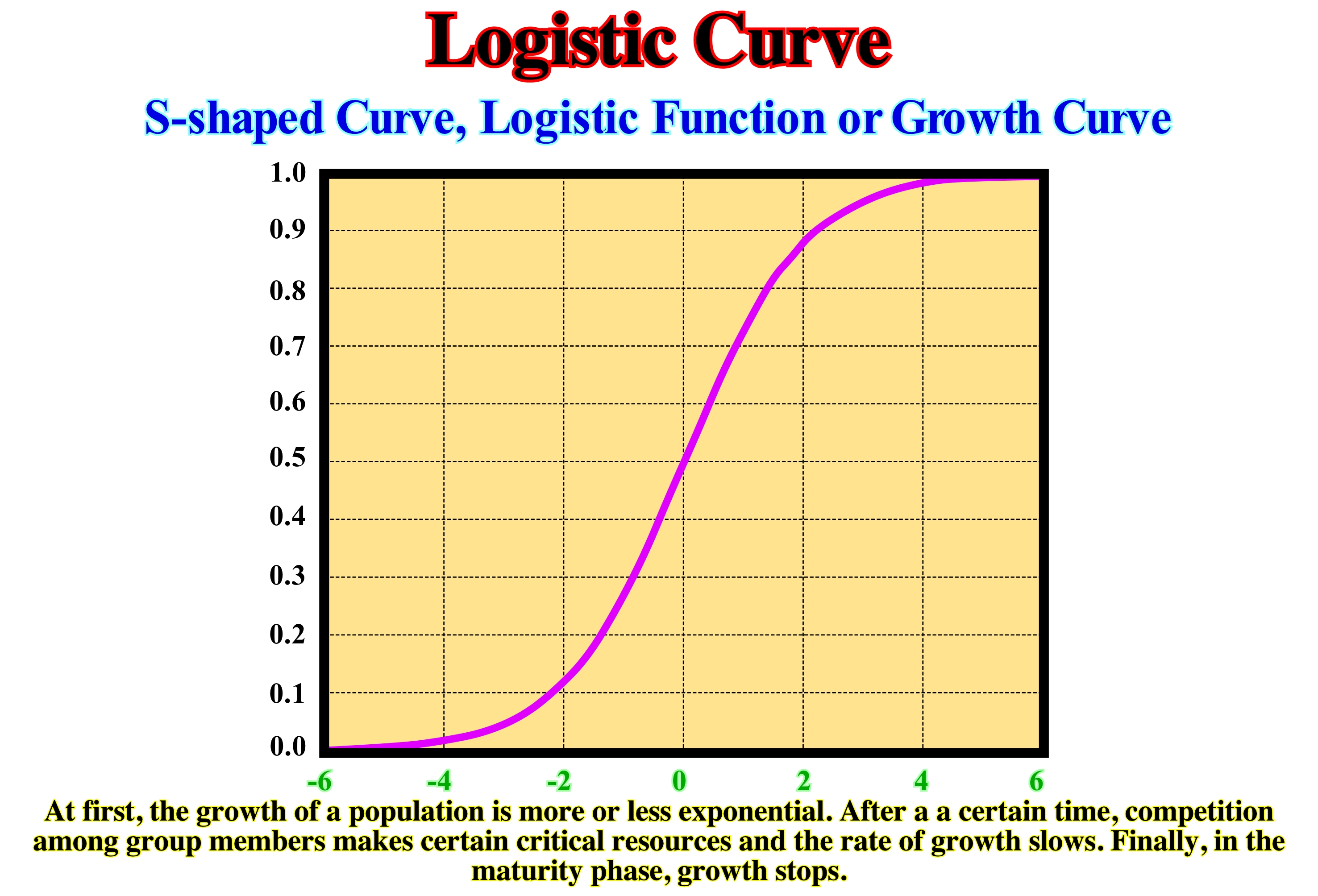
A logistic growth curve (Verhulst model) or just a logistic equation as shown in this figure is, essentially, a human population growth model. It was first published by Pierre Verhulst in 1845. Currently, it is used to model the growth or development of a wide variety of populations: (i) Sunflower height ; (ii) Length of railway lines ; (Iii) Development of infections; (iv) Oil production rate, etc. As illustrated above, the logistic function or logistic curve is the most common sigmoid curve. It models the S-growth curve of a series of sets. During the early phase, growth is almost exponential. Then, as saturation begins, growth slows, and in maturation, growth, virtually, disappears. Mathematically, a simple logistic function can be defined by the following formula: P (t) = 1/1 + E-T, where the variable "P" indicates a population and the variable "t" the time. The history of all oil fields, in the absence of external factors such as wars, strikes, economic problems, etc., can be, perfectly, represented by a logistic curve. In all fields, the rate of oil production after growing exponentially decreases, sometimes very rapidly, until the field is depleted. Constructing a curve derived from a logistic curve is very simple, since the derivative at each point of the logistic curve is tangent at this point.
Logistic Curve (Example).....................................................................................................................................Courbe logistique (Exemple)
Curva logística / Curva logística (ejemplo) / Logistische Kurve / 曲线 / Логистическая кривая / Curva logistica /
When the initial growth (of any set) is exponential, for later (competition or scarcity) to decrease and to become null in a phase of maturation. In some cases, a logistic curve, which is an S-curve, is often best illustrated by the curve of its bell-shaped derivative (Hubbert's Curve). The growth rate of a population, such as the growth rate of oil production, is proportional to the initial population and the amount of remaining resources (the fraction of oil that is yet to be produced).
See: « Hubbert‘s Peak, Oil Peak, Hubbert’s Law »
&
« Hubbert's Law »
&
« Oil Peak, Hubbert's Peak , Hubbert's Law »

The curve of the rate of oil production, which depends, linearly, on the amount of oil that still exists on the ground to be produced, i.e., the oil still remaining underground, is a function of time and can represent by a logistic curve or by its derivative as shown in this figure. The scales of the derivative curve are: (i) Time, in general, years in abscissa and (ii) Remaining Reserves in ordinates. In this example, it can be said that the technical data (expected value at the time of discovery) strongly suggest that from the year 1980, more reserves were produced than were discovered. However, the various oil companies and international organizations continued to say (these curves were made by J. Laherrere in 2003) that more reserves were discovered than were produced. Of course, all geoscientists knew and know, that was a lie. The vast majority of oil companies, but not all of them, in order to pass on such a message included in the remaining reserves not only unconventional reserves (e.g., reserves of the oil shales) but also what might be called the reserves (purely speculative reserves) to justify production quotas. Anyway, in the oil industry, whatever the curve is presented, there is always a maximum point of production based on the rate of discoveries, rate of production or cumulative production. At the beginning of the curve (before the peak) the rate of production increases, due to the rate of discoveries and the development of infrastructure. In the final part of the curve (after the peak) production decreases due to depletion of resources.
Logistic Function.....................................................................................................................................................................Fonction logistique
Função Logística / Función logística / Logistische Funktion / Logistic函数, 后勤功能 / Логистическая функция / Equazione logistica /
When the initial growth (of any set) is exponential, for later (competition or scarcity) to decrease and, finally, in a phase of maturation, become null. This type of function was initially studied by the Belgian mathematician Pierre François Verhulst who deduced it from the population growth. The rate of growth of a population, eg, the rate of growth of oil production is proportional to the existing population and the amount of resource remaining (in the case of oil, the fraction of oil still to be produced), which tends to limit population growth.
See: « Logistic Curve »
&
« Oil Peak »
&
« Hubbert's Law »
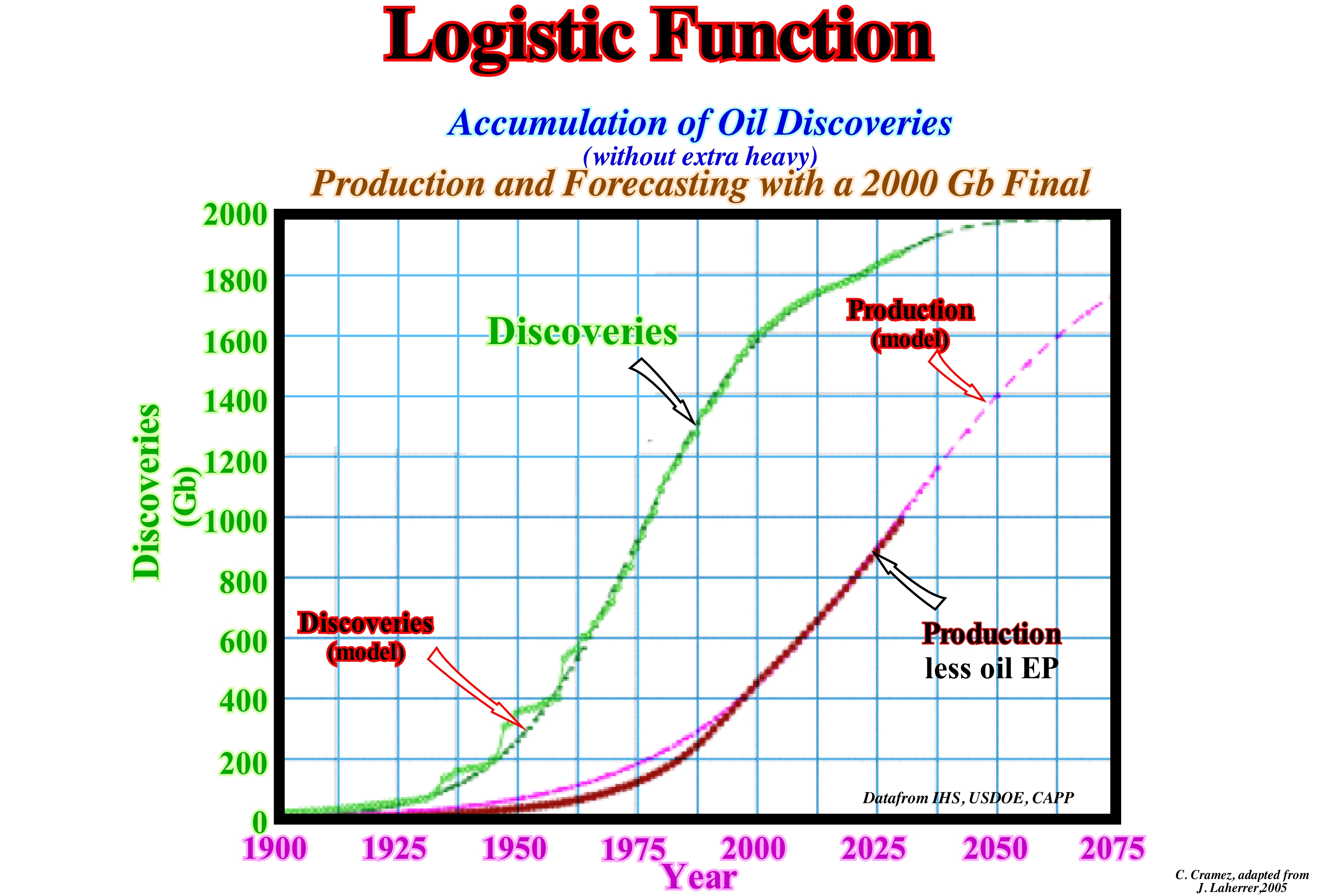
Logistic functions combine, in a single diagram, two characteristic types of exponential growth. The first type of exponential growth is the familiar increasing curve with a rising rate, that is, how growth is exponential: the growth rate is proportional to the amount of the function value (curve with the parabola half-face up) concave upwards. The second type of exponential growth is usually called limited exponential growth. This type of growth is decomposed into parts that are subtracted from a fixed limit. As the exponential decomposition tends to disappear, the differences at the fixed limit increase up to this limit (curve with a half parabola facing downwards). This type of function models a growth that is limited by certain fixed capacities. Logistic functions combine the first type of exponential growth (when values are small), with the second type of exponential growth (when values are close to capacity). Logistic functions model features with limited exponential growth. Logistic functions, which have a characteristic S form , apply to population studies, bacterial development, plant growth with seeds, analysis of fossil fuel reserves and production, etc. This figure that cumulated oil discoveries (extra-heavy excluded), production (lower curve), which is smaller than the cumulation of the discoveries (upper S curve) and forecasts until 2075 (for last reserves of 2000 Gb). As can be seen, the maximum derivative (inflection point) of the production curve (lower S curve) strongly suggests that the peak of production, if it has not already been reached, will be between 2010/2020.
Longitude...................................................................................................................................................................................................................................Longitude
Longitude / Longitud / Geographische Länge / 经度 / Долгота / Longitudine /
Angular distance, in degrees, minutes, and seconds, from a point east or west of the Greenwich meridian. Longitude lines are often referred as meridians.
See: « Latitude »
&
« Contour Map »
&
« Earth »
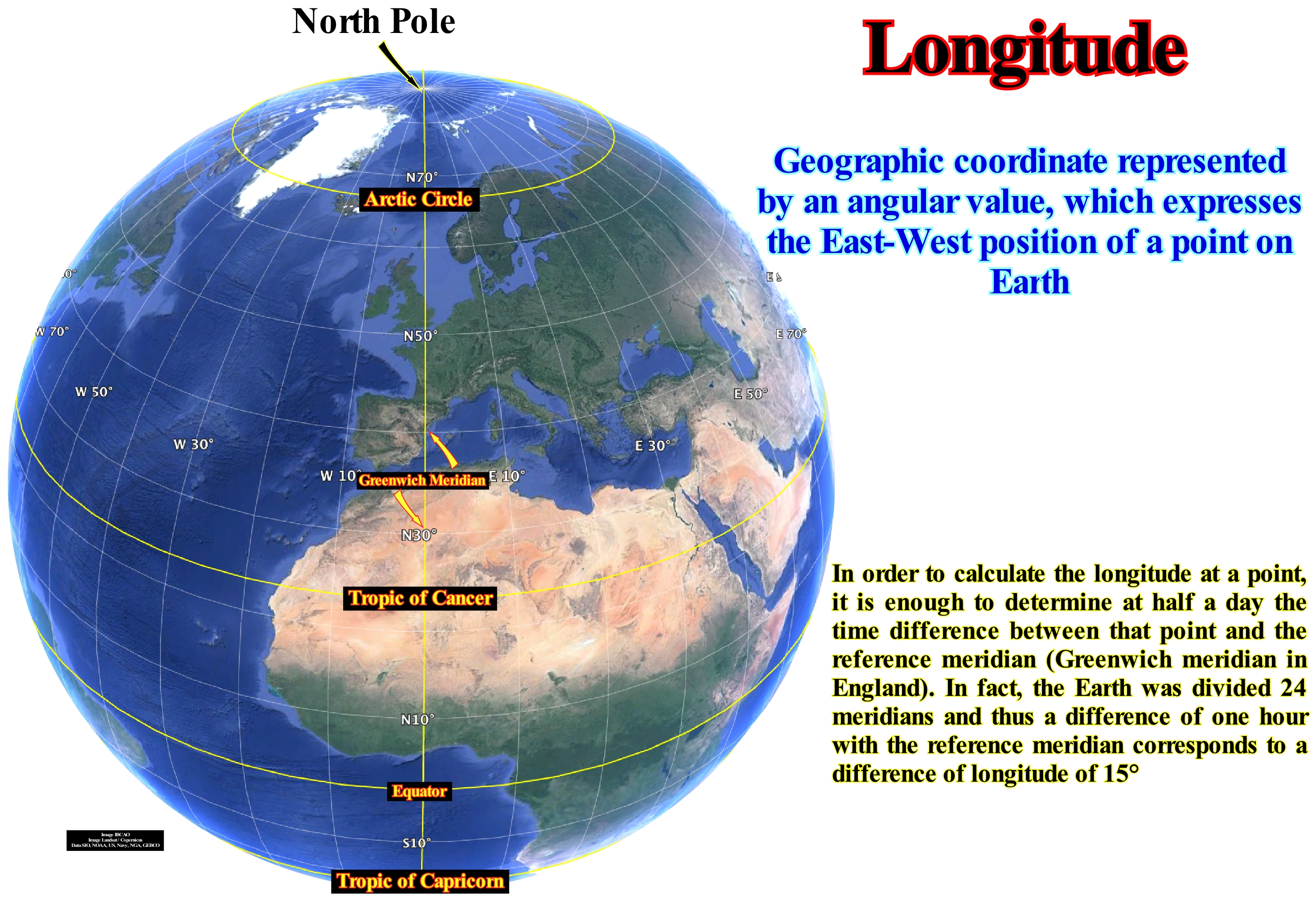
The longitude, which is, sometimes, represented by the Greek letter λ (lambda), describes the location of a place on Earth measured in degrees, from zero to 180 to East or West from Greenwich Meridian (it is the meridian which passes over Greenwich at the Royal Observatory on London surroundings, UK) and, by convention, divides the globe into the west and east. Unlike latitude, which has the equator line as a natural starting point, there is no natural starting position to mark the longitude. A meridian of reference had to be chosen. While British cartographers used the Greenwich Meridian long ago, other references were used as: El Hierro, Rome, Copenhagen, Jerusalem, St. Petersburg, Pisa, Paris, Philadelphia and Washington. In 1884 at the International Meridian Conference the Greenwich Meridian was adopted as the first meridian of the world. Each degree of longitude is subdivided into 60 minutes, and these in 60 seconds. A longitude is specified in degrees (°) degrees minutes (') 'seconds (''). If the locality is in the west a negative sign (-) is placed in front of the longitude. Instead of using the negative sign, you can also use the letters E and W to indicate "East" and "West", respectively. A longitude can be combined with a latitude to give a precise position of a place on Earth. Unlike a degree of latitude, which always corresponds to a distance of 111.12 km, a degree of longitude varies from 0 to 111.12 km if the distance is measured in a circle of the same latitude, the distance is 111.12 km times the cosine of latitude. If the distance is measured in a maximum circle, the distance is slightly smaller. The length of a point can be determined by calculating the time difference between the locality and Coordinated Universal Time (UTC). As one day has 24 hours and a circumference has 360 degrees, the Sun moves through the sky at a rate of 15° per hour (360° divided by 24 hours = 15° per hour). To perform this calculation, you need a clock by checking UTC, and determining the local time through astronomical observations (http://en.wikipedia.org/wiki/Longitude).
Longitude of Ascending Node.........................................................................Longitude du noeud ascendant
Longitude do nó ascendente / Longitud de nodo ascendente / Argument des Knotens / 升交點黃經 / Долгота восходящего узла / Longitudine del nodo ascendente /
Angle between a reference direction, called the origin of the longitude, and the direction of the ascending node (point where the orbit of the object passes through the plane of reference), measured in a reference plane.
See: « Orbit »
&
« Precession »
&
« Ecliptic »
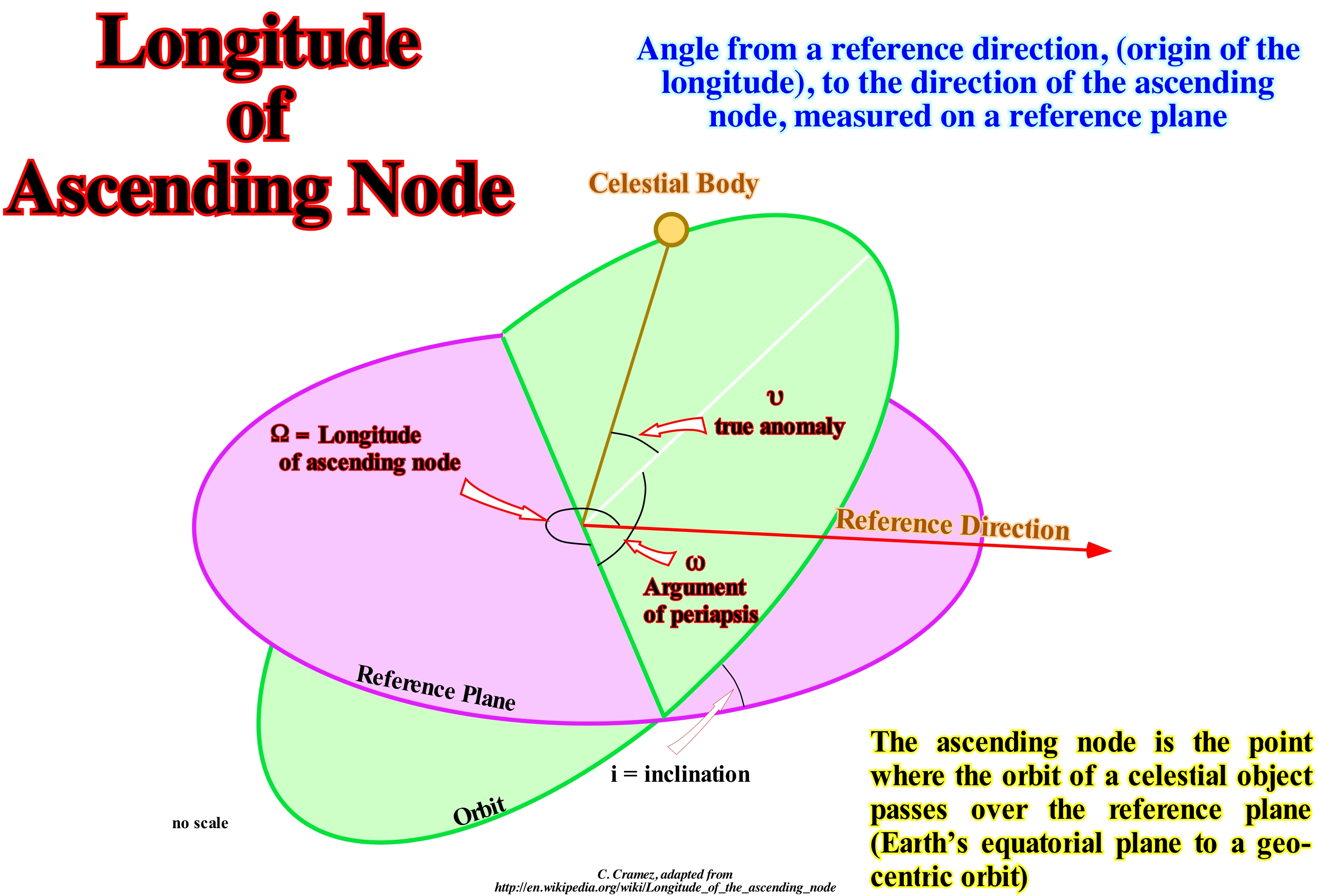
The longitude of the ascending node (Ω) is one of the orbital elements of the orbit of a celestial body. In addition to the longitude of the ascending node or other orbital elements of a celestial body are a set of six numerical values that allow to define its orbit around the Sun or any other celestial body of totally, univocal form. These six quantities are: (i) Orbital Inclination (i) ; (ii) Argument of the Perihelion (ω) - if it is not the Sun, we call it periapsis argument ; (iii) Larger Semicircle of the Orbit (a) ; (iv) Eccentricity of the Orbit (ε) and (v) Mean Anomaly of the Time (M0). The orbital elements of real objects tend to change over time. The evolution of the orbital elements takes place mainly due to the gravitational force of the other bodies. In the case of satellites, due to lack of primary sphericity, or to friction with the atmosphere. This is fundamental in the Earth's artificial satellites or other planets. In the case of comets, the expulsion of gas and the pressure of the radiation, or the electromagnetic forces introduce small non gravitational forces that must be considered to explain their movement. For an object that orbits around the Sun, it is the vertex angle in the Sun, which goes from the Aries Point (or vernal point) to the ascending node of that orbit, measured on the reference plane of the ecliptic (plane of Earth's orbit around the Sun, or the orbit described in this plane; the name comes from the fact that eclipses are only possible when the Moon is very close to this plane), in the direction of the translation of the body. The following are the lengths of the ascending node of the 8 planets of the Solar System: (a) Mercury = 48.331° ; (b) Venus = 76.67029° ; (c) Earth = 348, 73936° ; (d) Mars = 45.562° ; (e) Jupiter = 100.492° ; (f) Saturn = 113.64281° ; (g) Uranus = 73.98982° ; (h) Neptune = 131.79431°. Do not forget that the slope and the longitude of the ascending node indicate the plane of the orbit, that the perihelion argument guides the orbit within its plane, that the larger semi-axis (or the period, indistinctly) determines the size of the orbit, that the eccentricity determines its shape and that the time of passage through the perihelion (or the average anomaly) allows to locate the object in its orbit.
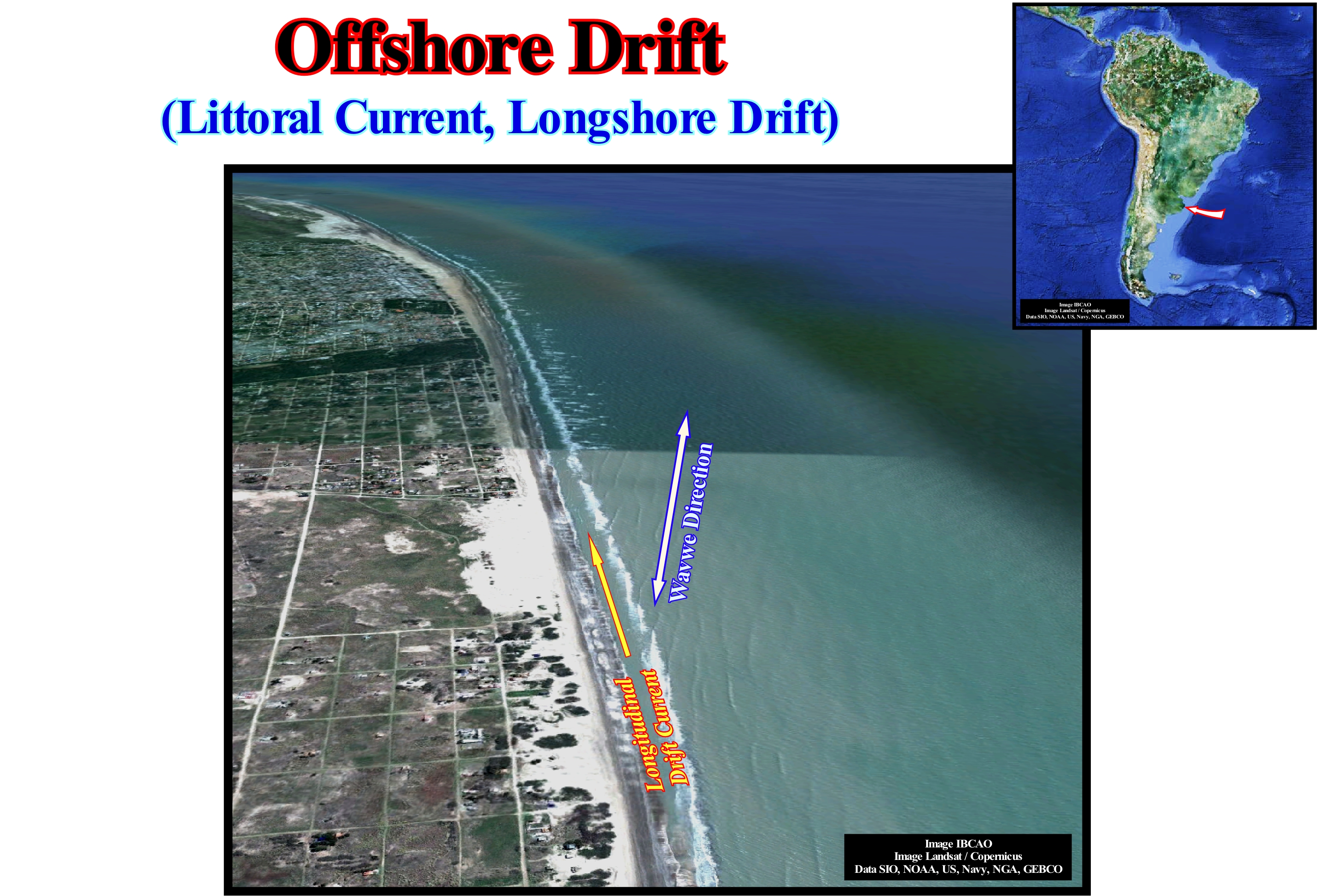
Longitudinal Drift Current (Offshore drift).......................................................Courant de dérive littorale
Corrente de deriva longitudinal (litoral) / Corriente de deriva del largo / Litoralströmung / 沿岸漂, 陆上漂移 / Дрейфовое продольное течение / Deriva littorale, Corrente longitudinale /
Accumulation of sand or gravel that forms on the backshore (a form of relief that constitutes the inner limit of the beach, which can be a cliff or a barrier insulated or not an internal lagoon), due to the concentration of sediments by the waves and wind.
See: « Beach Drifting »
&
« Shoreline »
&
« Swash Currents »
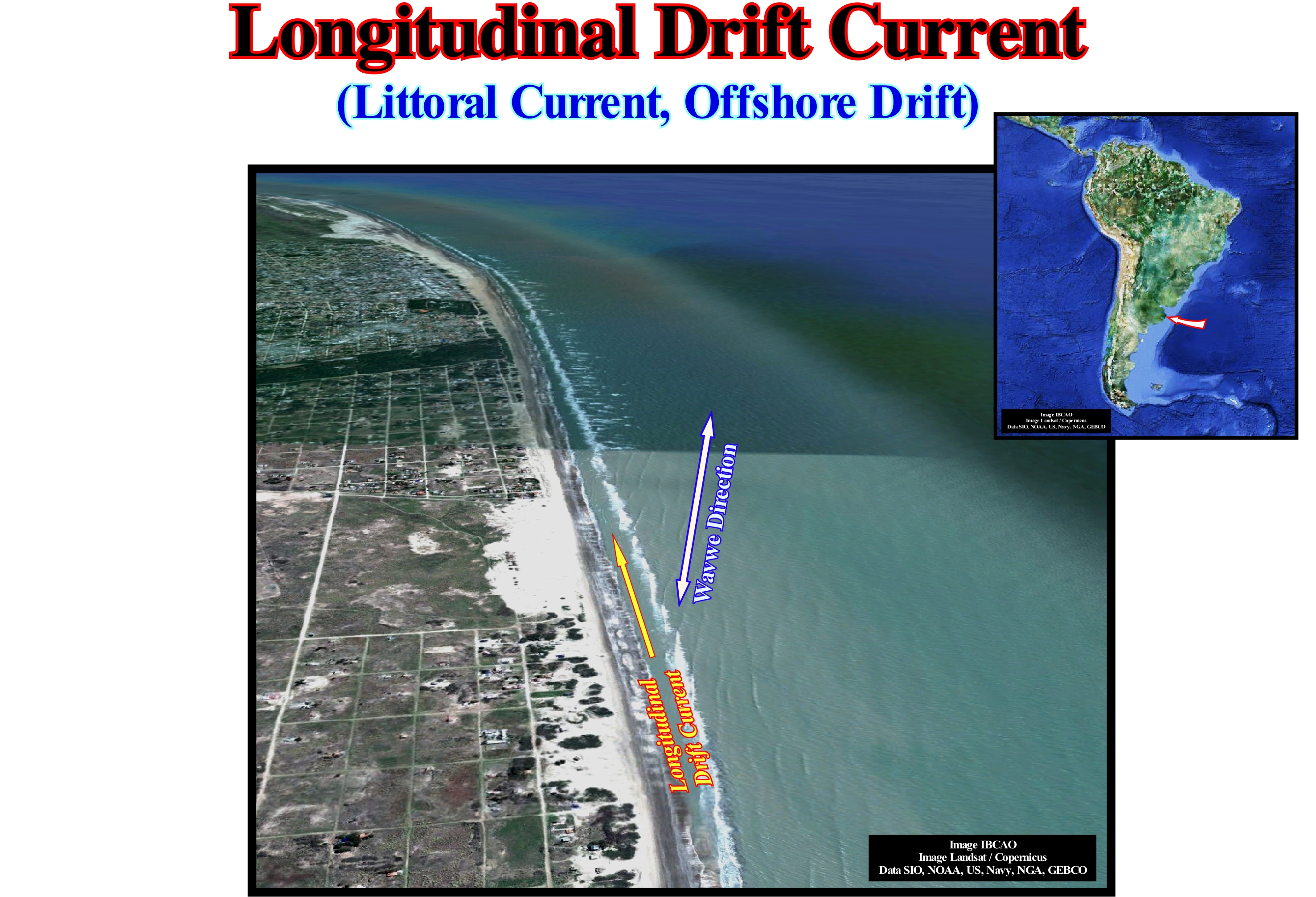
In this photograph of the east coast of Argentina, the dominant direction of the sea-waves is, clearly, visible (perpendicular to the blue arrow). The aggregation of the coastal strands that form the successive coastlines can be explained as the result of the longitudinal drift current. In fact, as soon as the waves break, in the surf zone, a current flows towards the beach. It flows, perpendicularly, to the direction of the wave crest (perpendicularly to the blue arrow drawn in the photograph). Such a current is called uprush current ( one of the two swash currents). Gradually, this up-dip current loses energy and, eventually, reverses itself, that is, it starts to lean seaward, following the slope of the sea floor. This current is the second swash current or backrush current. Thus, the uprush and backrush currents have not only an opposite direction, but also different flow directions. The interaction of these currents forms what some call geoscientists, a zigzag current, whose final result is the formation of a current, more or less, parallel to the coastline, called longitudinal drift current or littoral current or offshore drift, which is responsible for the erosion of the beach, in certain places, and for the deposit of sand in other places. In this example, the beaches are eroded in the south, along the agglomeration of San Clemente del Tuyu, and the sand is transported and deposited in the north, in the form of barrier bars. Often, to protect the shores of the coastal drift, populations build piers (quays or piers) perpendicular to the coastline. Once these protective structures are built, the width of the beach varies greatly on each side of the piers. The wider beach is the side of the jetty which offers a resistance to the offshore drift current, which loses transport competence deposits the sediments that it carries. When the wave direction is NO-SE, as in this example, and the NNO-SSE coastline, if a quay is constructed perpendicular to the coastline, the broadest beach will be located to the south of the quay.
Longitudinal or Dip Seismic line..........................................................................Ligne sismique transverse
Linha sísmica longitudinal / Línea sísmica transversal / Längs seismischen Linie / 纵向地震测线 / Продольный сейсмическая линия / Linea sismica longitudinale /
Seismic line whose orientation is more or less parallel to the direction of the terrigeneous influx (longitudinal line).
See: « Non-Marine Onlap »
Longshore..................................................................................................................................................................................................................Bord de la côte
Pré-praia / Pre-playa, Borde de costa / Longshore, Pre-Strand / 沿岸 / Береговой / Pre-spiaggia /
Part of the beach that is always submerged tha extendst from the limit of the lower tides to an undefined space (surf or bathing area for some geoscientists) at the bottom of which are the longshore bars and the longshorerunnels. The longshore is also known as ramp or edge of the coast ("bord de la côte" of French geoscientists).
See : « Shoreface »
&
« Littoral »
&
" Wave Action Level "
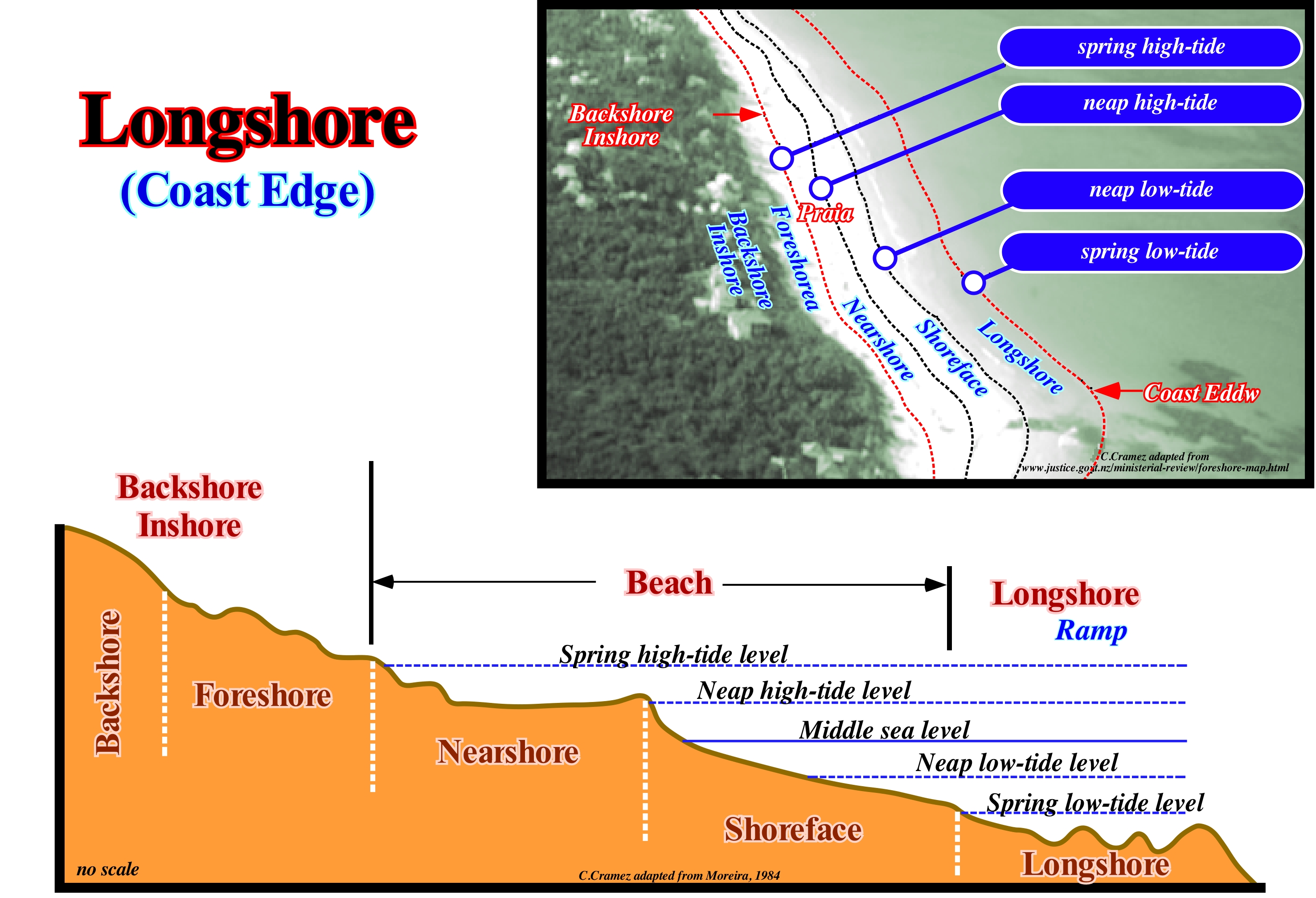
As shown in the diagram and on the tentative geological interpretation of the photograph, where the houses give the scale, in a beach (stricto sensu), according to the tides we can differentiate several zones: (i) Longshore ; (ii) Shoreface ; (iii) Nearshore ; (iv) Foreshore and (v) Backshore/Inshore. The longshore is the region that is always covered with water. It extends seaward from the spring low-tide level to a not very well defined outer boundary. It is considered by many geoscientists to be equivalent to the breaking zone, in which the sea floor shows longshore ridges (longshore bars) and longshorerunnels, whose amplitude can be higher than 1 meter. The shoreface, which corresponds to the lower part of the strand, that is, between the limits reached by the spring and neap low-tide levels, has a very weak slope, although higher than that of the longshore. It is, generally, formed by fine sediments, despite the fact that it may contain coarse sedimentary particles transported longitudinally. The nearshore is the part of the beach that extends in the space reached by the swash currents, between the neap and spring high-tide levels. It is separated from the foreshore by the beach berm and from the shoreface by the inflection line. The foreshore is the upper part of the beach. It has a very steep slope and it is hit by sea-waves just during the spring high-tides and storms. When well developed, the foreshore has dome obstacle dunes (foreshore dunes) because of vegetation. The surface reached by the waves is modelled with berms formed by a platform (berm) and an abrupt (small escarpment). The inflection line between the berm and the abrupt of each berm is the berm crest. The highest berm crest is called the beach-crest. All these forms are modified according to the situation of the tide and the height of the waves. The backshore (inshore) is relief with abundant vegetation (inner boundary of the beach). Th backshore can be a cliff or barrier bar, isolating or not an interior lagoon. As shown in the photograph, it is in the backshore that buildings (usually secondary homes) are generally built.
Longshore Drift (Littoral current, offshore drift)...........................................................Courant de dérive littorale
Corrente de deriva longitudinal / Corriente de deriva del largo / Litoralströmung / 沿岸漂, 陆上漂移 / Дрейфовое продольное течение / Deriva littorale, Corrente longitudinale /
Accumulation of sand or gravel that forms on the backshore (a form of relief that constitutes the inner limit of the beach, which can be a cliff or a barrier bar insulated or not an internal lagoon), due to the concentration of sediments by the waves and wind.
See: « Beach Drifting »
&
« Shoreline »
&
« Swash Currents »
In this photograph of the east coast of Argentina, the dominant direction of the sea-waves is, clearly, visible (perpendicular to the blue arrow). The aggregation of the coastal strands that form the successive coastlines can be explained as the result of the longitudinal drift current. In fact, as soon as the waves break, in the surf zone, a current flows towards the beach. It flows, perpendicularly, to the direction of the wave crest (perpendicularly to the blue arrow drawn in the photograph). Such a current is called uprush current one of the two swash currents). Gradually, this up-dip current loses energy and, eventually, reverses itself, that is, it starts to lean seaward, following the slope of the sea floor. This current is the second swash current or backrush current. Thus, the uprush and backrush currents have not only an opposite direction, but also different flow directions. The interaction of these currents forms what some call geoscientists, a zigzag current, whose final result is the formation of a current, more or less, parallel to the coastline, called longitudinal drift current or littoral current or offshore drift, which is responsible for the erosion of the beach, in certain places, and for the deposit of sand in other places. In this example, the beaches are eroded in the south, along the agglomeration of San Clemente del Tuyu, and the sand is transported and deposited in the north, in the form of barrier bars. Often, to protect the shores of the coastal drift, populations build piers (quays or piers) perpendicular to the coastline. Once these protective structures are built, the width of the beach varies greatly on each side of the piers. The wider beach is the side of the jetty which offers a resistance to the offshore drift current, which loses transport competence deposits the sediments that it carries. When the wave direction is NO-SE, as in this example, and the NNO-SSE coastline, if a quay is constructed perpendicular to the coastline, the broadest beach will be located to the south of the quay.
Longshore Ridge (Longshore bar)................................................................................................................................Crête pré-littorale
Crista pré-litoral / Cresta prelitoral / Strandwälle / 沿岸脊 / Береговой хребет / Prelitorale cresta /
High point of large-scale beach ripples (up to 1 meter), which form at the outer boundary of the shoreface (longshore). The low points or troughs are called longshorerunnels. These undulations are induced by the drainage of the swash currents, particularly, by the backrush current which is the swash current which is directed towards the sea.
See: « Karst »
&
« Littoral »
&
« Intertidal Beach »
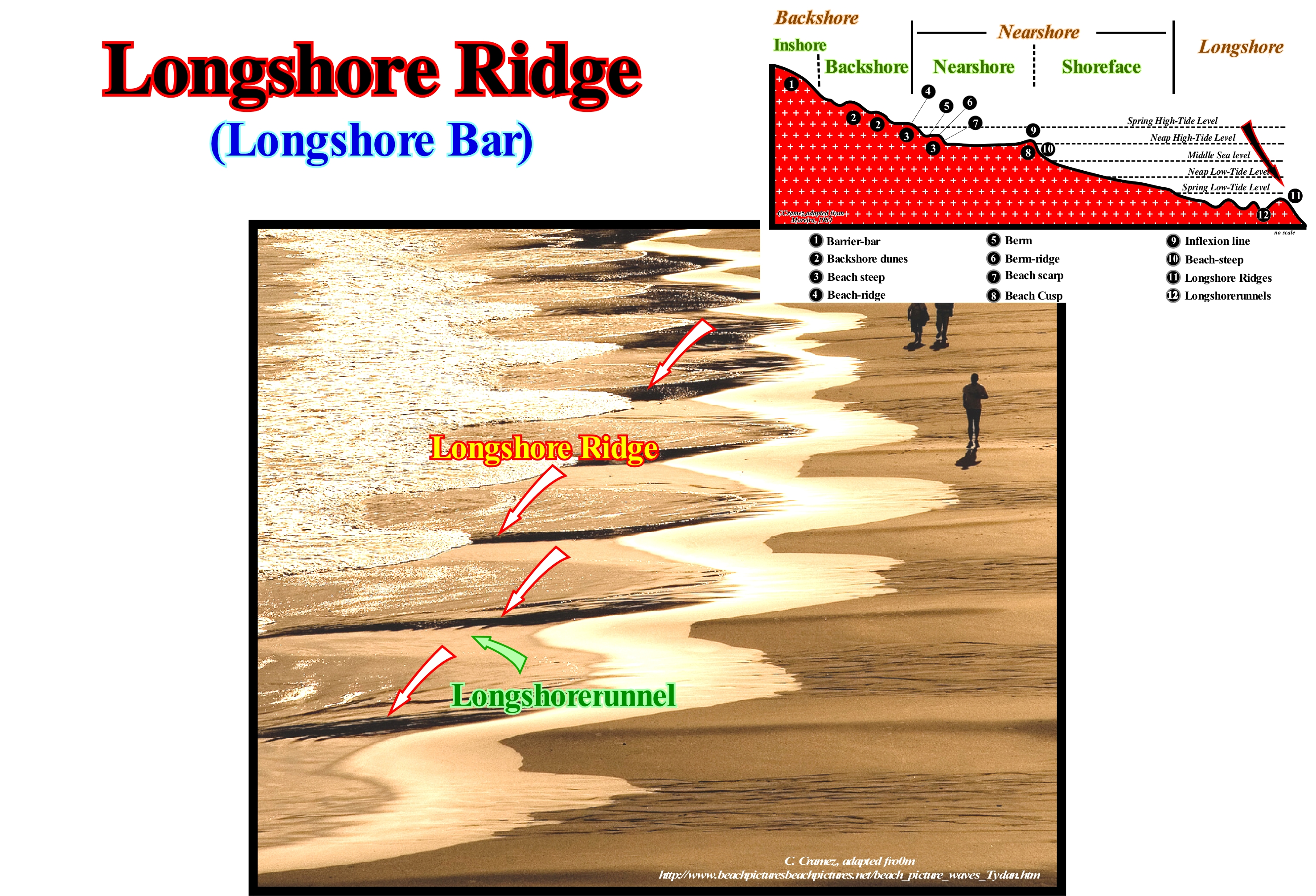
The longshore ridges form on the shoreface, that is, on the lower part of the strand that comprises the space that extends between the limits reached by the neap and spring low-tide levels. The slope is, generally, very weak and the material is thin, however, coarse materials transported longitudinally may be encountered. On the surface of the shoreface there are marks of bioturbation (marks of living beings, such as troughs and dejections of crabs or sandstones, birds' feet, etc.) and marks of low amplitude ripples (3-15 cm), more or less, linear and parallel to each other and to the breaking line, which can be symmetrical or asymmetrical and are called beach ripples. These undulations, as suggested in this figure, are created by the flow of the swash currents, in particular by the uprush of the backrush current, which is directed seaward. At the outer limit of the shoreface may appear ripples of greater amplitude (up to 1 meter) that are called the longshore ridges. In this photograph, given the amplitude of the ripples, it can be said that the backrush current created small ridges and longshore ridges. As the longshore ridges are, theoretically, created by the erosion of the backrush currents, they must be oriented more or less perpendicular to the coastline, since one of the characteristics of the backrush currents is that they flow along the slope of the beach. These structures should not be confused with the beach cups (semicircular with the cavity facing the sea and separated from each other by sharp, corniform tips, called wings or tips of the crescent), that are formed during the flood (high-tide current), due to the movements of inversion and interference of the swash currents.
Longshorerunnel.............................................................................................................................................................................Sillon prélittoral
Caneito (sulco pré-litoral) / Depresión prelitoral / Strandrinnen / 沟的临滨 / Прибрежный спуск / Solco Prelitorale /
Depression of the beach ripple marks, relatively, large, located on the outer shoreface boundary and created by the drainage of the swash currents and, particularly, the backwash current.
See : « Shoreface »
&
« Beach Ripple-Marks »
&
« Backwash Current »
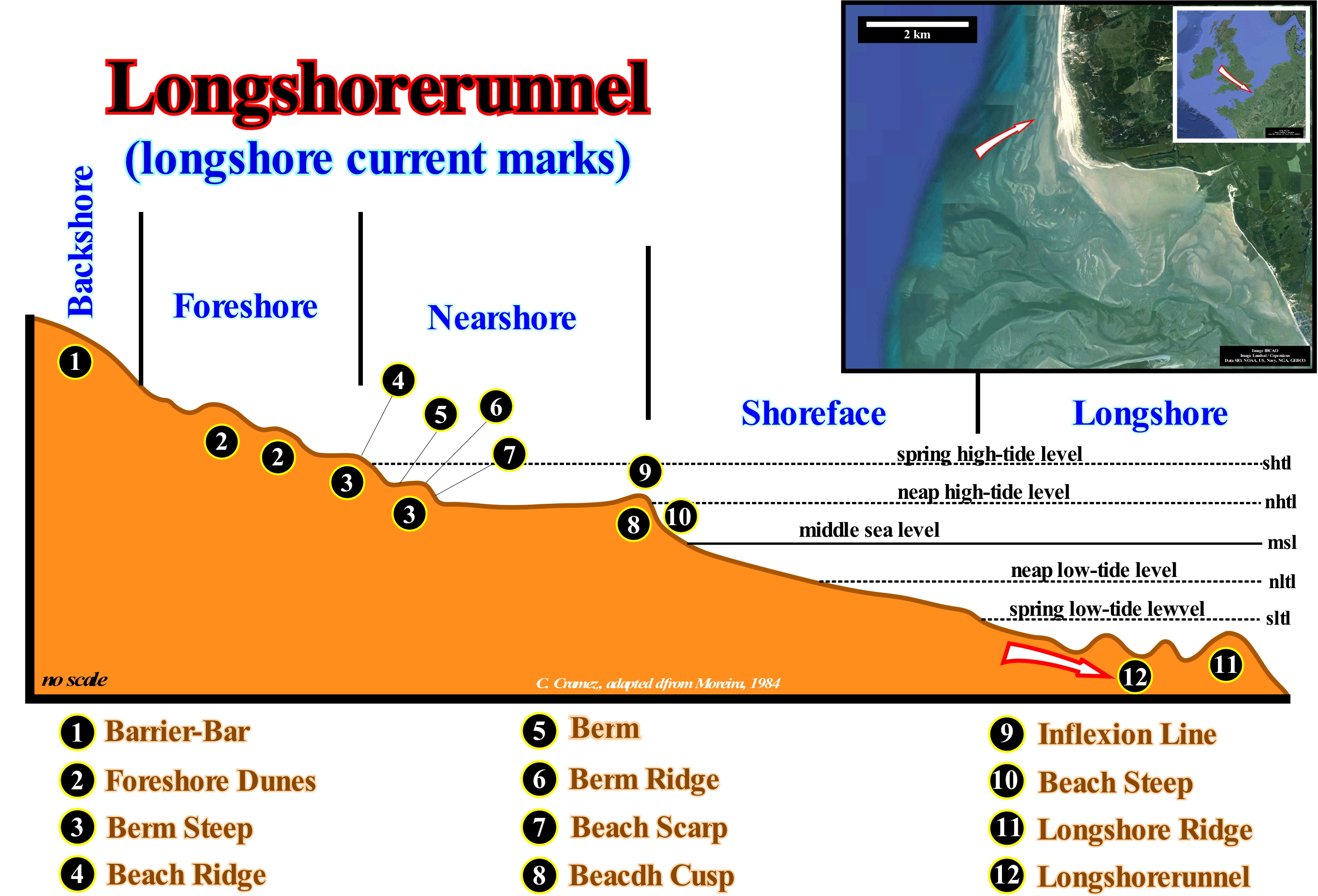
Longshorerunnels, as well as the longshore ridges are sand ripples, of low amplitude, more or less parallel to the shoreline, which are, mainly, found in the longshore with weak sandy terrigeneous influx. The origin of these structures is problematic. Three explanations have been advanced: (i) When the longshorerunnels are, more or less, stationary, they are probably induced by the formation and growth of strand barrier bars created by sea-waves with short wave-lengths (this is, probably, the case in macro-tide coast) ; (ii) When the longshorerunnels are mobile, they are, probably, the result of the continentward migration of offshore bars and depressions (parallel to the shoreline) ; (iii) When the longshorerunnels form in a, more or less, periodic manner, they can result from a channelling erosion of the sandy sediments, partially saturated with water, during the tides. This type of erosion is, mainly, caused by the turbulence associated with the hydrodynamic jumps of the waves, created, above all, where the backwash currents find the uprush current. The enigma of the formation of these sedimentary structures is perhaps best approximated by the recognition of a genetic diversity for a great generic diversity. These structures are formed, mainly, on the lower beach (shorefore), which corresponds to the lower part of the strand (space that extends between the limits reached by the spring and neap low-tide levees. The slope of the shoreface is very weak and the material is, generally, thin (the presence of coarse material transported longitudinally can not be excluded). On the surface of the shoreface, bioturbation marks (marks of living beings, such as debris from crabs or sandstones, bird legs, etc.) are very important. Beach ripples associated with swash currents are very common. Note that, certain geoscientists consider the foreshore as, more or less, the set of nearshore and shoreface.
Lotic (Water)...........................................................................................................................................................................................................................................Lotique (Eau)
Lótica (água) / Lótica (agua) / Fliessenden (Wasser) / 激流(水) / Проточная (вода) / Lotiche (acqua) /
Water flowing down the coast. A lotic ecosystem contrasts with a lentic, which involves more or less stagnant terrestrial waters such as lakes and ponds.
See : « Lentic (water) »
&
« Stream »
&
« River »
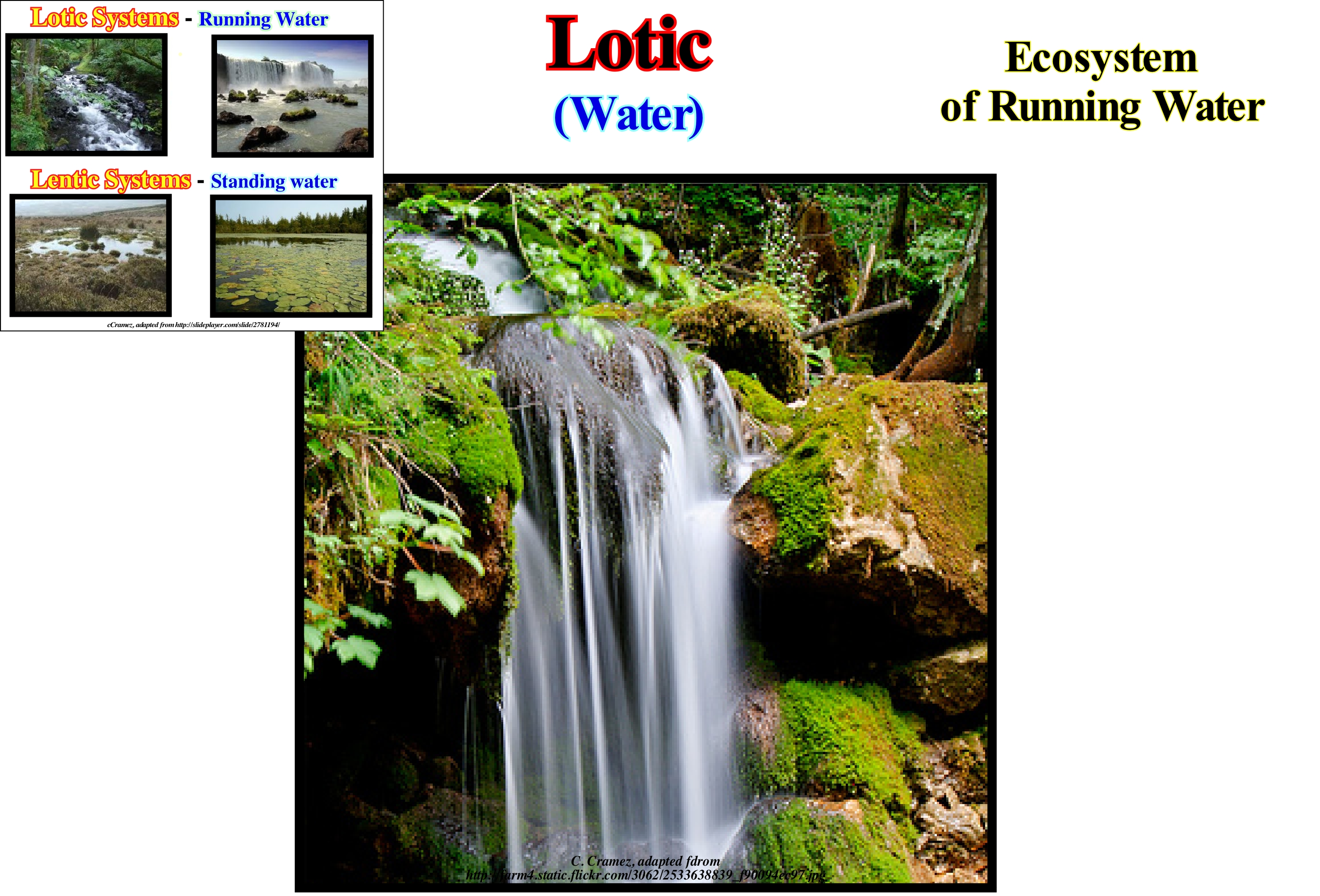
The ecology of a lotic system is the study of biotic and abiotic interactions in flows of continental water-courses. With the ecology of the lentic systems, which implies less dynamic continental waters, such as lakes or lagoons, these domains form the most general areas of study for freshwater or aquatic ecology. The lotic means have very diverse forms, ranging from streams to large rivers several kilometers wide, but have invariabilities that justify their joint study. Certain common characteristics make the ecology of water-courses a unique discipline in relation to other aquatic habitats: (i) Flows are unidirectional ; (ii) The systems are in a state of constant physical change ; (iii) There is a high degree of spatial and temporal heterogeneity at all scales (habitats) ; (iv) The variability between lotic systems is large ; (v) Biota is specialized to live under run-off conditions, etc. Flows are the operator in key abiotic systems of lotic systems that influence their ecology. The force of the water flows may vary according to the system, due to a continuum of fast or slow flows, whirlwinds are almost seen as lentic systems. The flow velocity of the water can be variable within the systems and between different systems. This is typically based on the variability of the friction with the bottom and the margins of the channel, the sinuosity, the obstructions and the inclination. In addition, the amount of water entering the system from direct precipitation, melting and/or groundwater can affect the flow velocity. Waters can change the shape of the river bed through erosion and deposition processes, creating a variety of habitats, including currents, landslides and tides. Light is important for lotic systems because it produces the energy required for primary productivity through photosynthesis, and can also produce a refuge for species trapped in the shadows. The amount of light a system receives can be linked to a variable combination of internal and external flows.
Love Wave........................................................................................................................................................................................................................Onde de Love
Onda de Love / Onda de Love / Love-Wellen / L波 / Волна Лове / Onde di Love /
Surface wave, which does not travel within the Earth or any other geological body as does P waves (longitudinal or compression waves, which compress and dilate the ground in the direction of propagation) and S waves (transverse waves, which move the ground perpendicular to the direction of propagation). A Love wave, unlike a Rayleigh wave, has only one horizontal component. Love waves or Q waves cause horizontal displacements during earthquakes.
See: « Seismic Wave »
&
« Rayleigh Wave »
&
« S Wave »
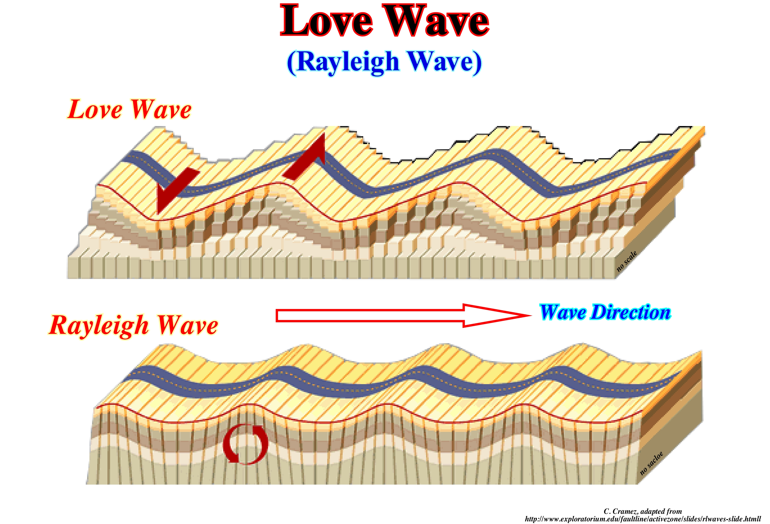
Love waves are easily differentiated from Rayleigh waves. Rayleigh waves have a vertical and horizontal component, which is not the case with Love waves that have only one horizontal component. During earthquakes, certain seismic waves move, exclusively, along the Earth's surface. They are called surface waves by contrast to body or volume waves. Surface waves can be either Love or Rayleigh. Above, Love waves move sideways, and Rayleigh waves move in a circle (orbital motion), that is, forward, down, and then back and up like the sea-waves. The surface waves decrease in depth. Miners who work a few tens of meters deep, rarely, feel them during earthquakes. As Love waves travel to the surface, their amplitude decreases, exponentially, with the depth of the earthquake. Given its confinement to the surface, the amplitude decreases by 1/√r, where r represents the distance the wave travelled from the epicentre*, which means that surface waves slow down more, slowly, than P or S body waves. Large earthquakes can generate waves of Love that give the return to Earth before dissipating. They take a long time to dissipate because it contains a lot of energy. That is why the waves of Love are very destructive near the epicentre (vertical hypocenter).
(*) Point in surface resulting from the intersection of the vertical line passing through the hypocenter or seismic focus, which is the point where the earthquake occurs in depth.
Lower Mud-Flat (Slikke).......................................................................................Plate-forme de basse-marée (Vasière molle)
Plataforma de baixamar / Slikke, Plataforma de bajamar / Schlick, Slikke / 潮泥滩台地(软泥滩) / Илистая низменная прибрежная полоса морского дна / Piattaforma di bassa-marea (mudflat soft), Piattaforma di bassa marea /
The lowest part of a pelitic strand, flooded in all the neap high tides and at open air during the low tides. It is a very little sloping platform, built by soft mud, where the tidal channels are inserted sometimes with sandy material at the bottom.
See: « Beach »
&
« Abrasion Platform »
&
« Schorre »
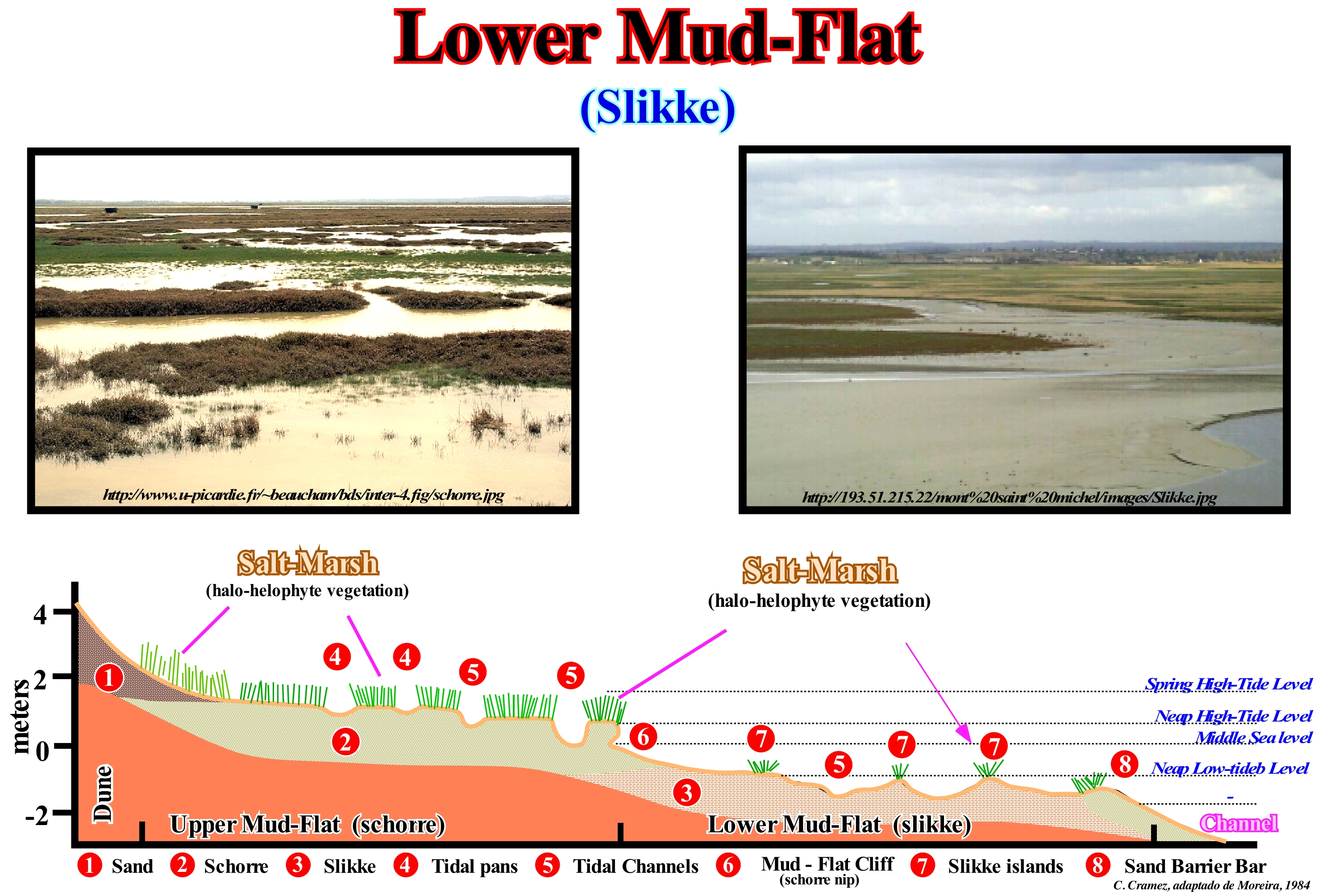
In the morphology of the upper mud-flat (schorre) and the lower mud-flat (slikke) of an estuary (downstream of the dunes, shown in this sketch), from the bottom to the top, it is, relatively, easy to recognized: (i) The slikke, on the low-tide platform ; (ii) The schorre on the high-tide platform and (iii) The sandy dunes. On the other hand, in the low tide platform, which is limited upstream by mud-flat cliff (schorre nip) the and downstream by a canal, we recognize: (a) Tidal channels and (b) Tidal islands, while in slikke, between the islands, tidal pans are recognized. The lower mud-flat (slikke) is, with upper mud-flat (schorre) one of the characteristic areas of the mud-flats of the strand (coastal zone between high tide and low tide levels). These two areas of marshes and bogs are characterized by many different biological environments downstream from the coastal marshes. The lower mud-flat (slikke) is the lower part the strand, i.e, the part that is most often flooded in each high-tide. The sediments are of marine origin (marine erosion) and terrestrial (mainly of the material transported by water-courses). They are relatively fine: muds, clays, shaly sands, etc. The structure and thickness of the lower-mud flat (slikke) vary with the seasons of the year. They depend, mainly, on the abiotic context, namely, on the rheological characteristics, on the terrigeneous influx carried by the floods and on the importance of the tides. The lower mud-flat, also exposed to external conditions (currents, salinity, exposure to solar ultraviolet radiation during low tide, etc.), depends on the biotic context (bioturbation activity of organisms, especially the perforating organisms). The lower mud-flat is poor in vegetation but contains a large amount of bacterial biomass, which plays a key role in the auto-depuration and recycling processes of the dead matter. It also houses a wide variety of species of molluscs (mussels, cockles, etc.), herbivorous molluscs, green crabs, herbivores or fish catchers (mullet, bars, etc.), many worms and molluscs that live in the mud salty, and are a much appreciated food of birds coming to feed themselves during low tide. In the lower mud-flat, biomass is abundant (up to several thousand organisms per square meter during low tide in temperate zones, at least 60 species of fish and crustaceans feeding all or part of their life there). During low-tide, there are thousands of birds that come there looking for molluscs or macro-zoobentos. In general, all geoscientists admit (http://www.ecosociosystemes.fr/schorre.html) that the coastal waters of Europe are characterized by a very marked dichotomy downstream of the schorre and upstream of the slikke. On the other hand, they are almost all agreed that: 1) Slikke is characterized by a halophyte vegetation (adapted to salt) that is distributed in different floors ; (2) The lower part of the slikke is covered at every tide, except during the neap tides, and it is colonized by plants, such as soda (maritime swede) and sea aster (Aster tripolium) ; 3) The middle part of slikke has a thick vegetation due to the obione (Portulacoides Obione) ; 4) The high part of the slikke is composed of fennel (Salicornia sp.), Spartina (Spartina) and (Atropis), sea lavender (Limonium) or artemisia (Artemisia vulgaris) ; 5) The schorre is the part of the mud that is covered only when the great tides ; (6) the salty water is, mainly, composed of soft, smooth-looking, non-vegetated muds containing a large number of bacteria which enable it to play an essential role in the processes of assimilation and recycling of dead organic matter ; 7) The schorre shelters a variety of bivalve species (clams, cockles, etc.), small gastropods, green crabs and (mullet, squares, bars) ; 8) The schorre is frequented by species of shorebirds living in the mud (torches, knights, snipe, tailor), herons and other black-headed gulls and seagulls, chestnuts or mariners, but also by many terrestrial invertebrates and such as spiders, which since the tide is installed run on the water surface, to hunt prey, but also to find partners.
Lower Bathyal.........................................................................................................................................................................................Bathyal inférieur
Batial Inferior / Batial inferior / senken Sie Bathyal / 降低深海 / Нижняя батиальная область / Abbassare batiale /
Sub-environment bathyal, in which the waterdepth varies between 1,000 and 3,500 meters.
See : « Bathyal »
&
« Abyssal »
&
« Middle Bathyal »
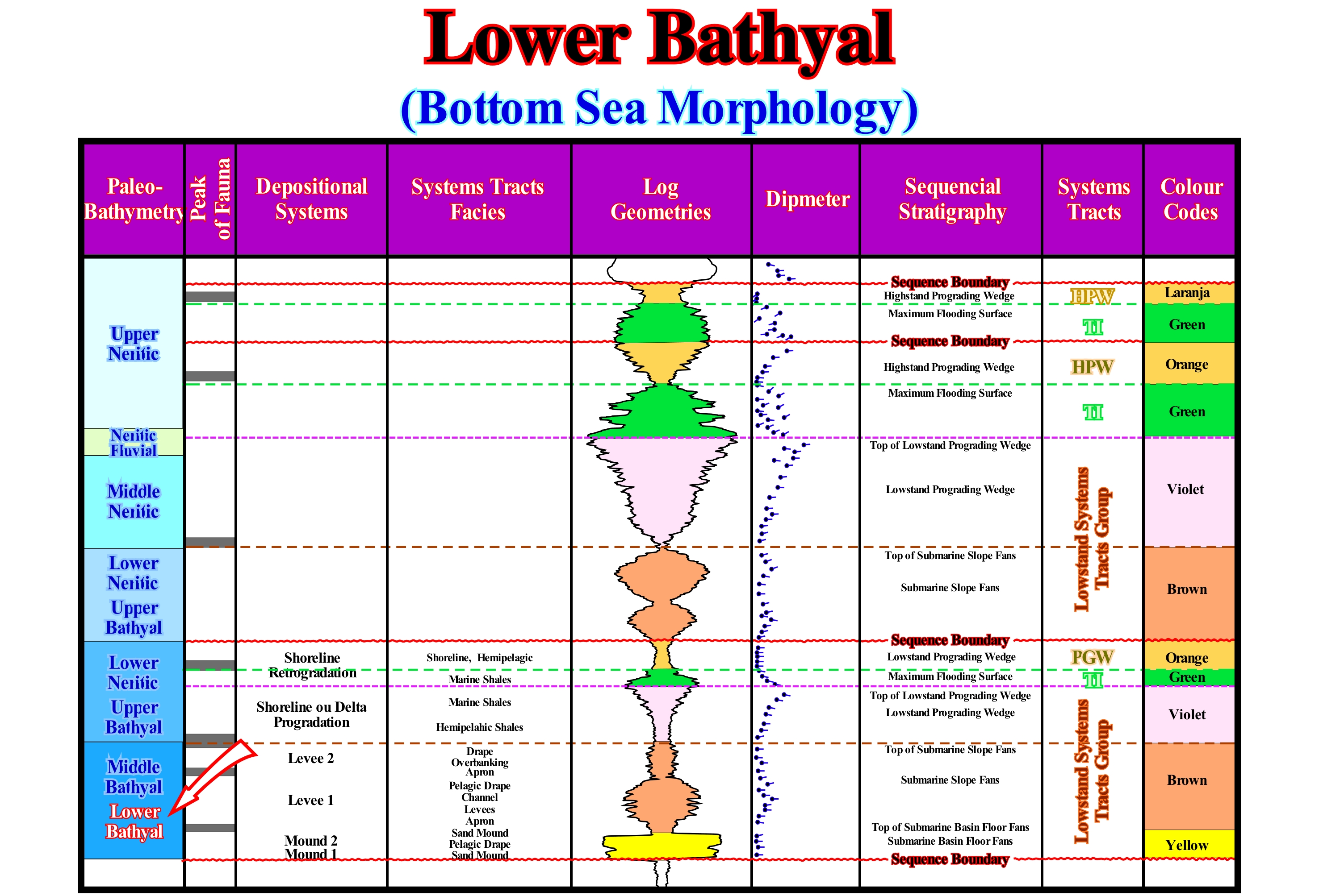
The lower bathyal sub-environment is part of the bathyal environment which makes the connection with the abyssal plain. It is the domain of the first submarine slope fans, which are deposited since the relative level of the sea begins to rise. Submarine basin floor fans, on the contrary, settle, during relative sea level falls, preferably, on the abyssal plain. When the turbidite (or turbidity) currents decelerate, due to the lower slope break (abyssal plain - continental slope limit), they lose competence (transport) and the transported sedimentary particles begin to settle down. It can be said the deposit of the submarine basin floor fans (SBFF) is synchronous with the surface of erosion caused by the relative sea level fall. In other words, the age of the submarine basin floor fans gives the age of the lower unconformity or lower boundary of the associated sequence-cycle, although, in the abyssal plain, there is no unconformity, but rather a correlative paraconformity. When the turbidite currents are very competent, which implies a large volume of material transported, the submarine basin floor fans are separated from the rupture between the continental slope and the abyssal plain (deposited further away). Thus, the submarine slope fans (SSF) can be deposited, directly, in the abyssal plain. In this figure, the sequential analysis of an exploration well is outlined. In the first column are marked the depositional environments. At the bottom it is observed that the sediments deposited in the lower bathyal sub-environment are the submarine slope fans (SSF) and that in the middle bathyal, they correspond to the apron (basal slope deposit) and to the natural marginal dikes (levees) of the submarine slope fans, which were deposited on the submarine basin floor fans. In upper bathyal environment, the sediments are mainly deltaic. In the electrical logs, the submarine slope fans have, generally, coarsening upward pattern, whereas the submarine basin floor fans have a cylindrical pattern. The interface between the basin and slope submarine fans corresponds to a fauna peak, which means that the non-deposition hiatus between the two turbidite systems allowed the accumulation of large numbers of remains and fragments of animals and plants.
Lower Delta Plain (Lower delta, tidal delta plain).......................Plaine deltaïque inférieure (Bas du delta)
Planície deltaica inferior / Planicie deltaica inferior / Niederdelta / 下三角洲平原 / Нижняя дельтовая равнина / Piana deltizia inferior /
Area between the low and high tide limits, i.e., the intra-tidal zone. Typically, the lower delta plain corresponds to the brackish water area and saline environments, where a whole series of sedimentary deposits are settled, such as levees, flooding deposits, crevasse splays (associated with distributives), etc. These deposits can be, more or less, modified by the influx of marine sediments during the storms.
See: « Delta »
&
« Coastal Plain »
&
« Prodelta »
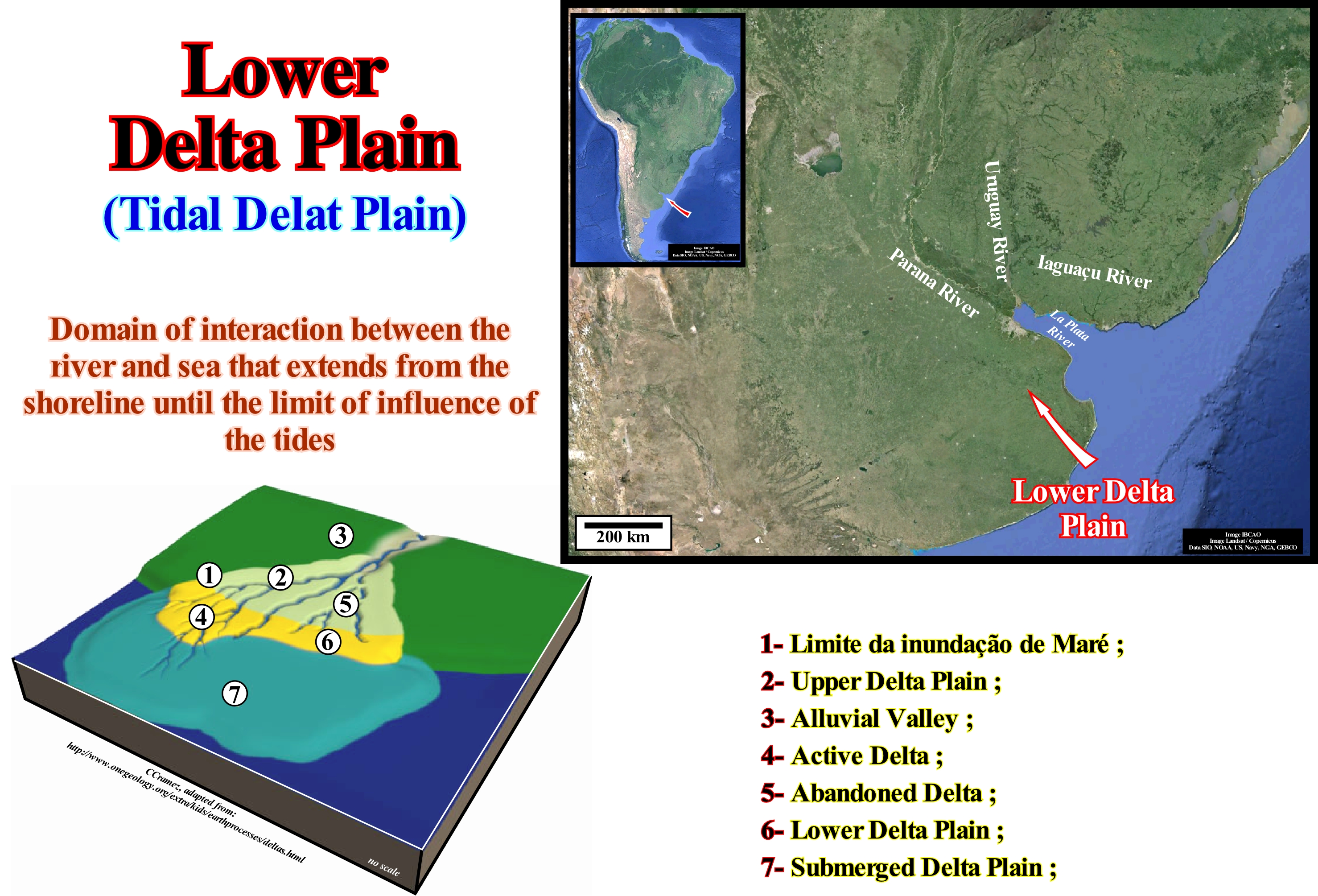
From upstream downstream, the physiographic elements of a delta are: (i) Upper or Sub-aerial Delta Plain, which can be divided into high upper delta plain (active or abandoned) and low upper delta plain (active or abandoned) ; (ii) Lower or Subaqueous Delta Plain ; (iii) Delta Front ; (iv) Prodelta and (v) Bottom of the Delta (corresponds to the sub-horizontal lower layers that are, sometimes, present in certain types of deltas and in which turbidite sandy horizons, i.e., proximal turbidites can be found. These physiographic elements, characterized by typical depositional systems, are synchronous and genetically associated. They form a sequence-paracycle and are deposited during the stability period of relative sea level that occurs after each relative sea level increment (eustatic paracycle) of a marine ingression. In fact, a significant marine ingression (relative sea level rise) is not done in continuity, but by increments separated by stability periods of relative sea level*, i.e. the relative sea level rises, stabilizes, and then rises again, etc. A vertical stacking of sequence-paracycles of this type, i.e., of deltas of the same sedimentary systems tract or systems tracts belonging to sequence-cycles, forms what the geoscientists call delta building. The lower delta plain of the Paraná Delta Building (province of Buenos Aires, Argentina) covers about 2,999 km2. This area, as illustrated in this figure, at present time, it corresponds to the downstream sector of the De La Plata river, up-build and out-build into the estuary of the river. The hydrology of this lower delta plain is, mainly, determined by the estuaries of the Paraná and la Plata rivers. In reality, la Plata river is not a river, but rather the estuary created by the Paraná and Uruguay rivers that form, on the Atlantic coast of South America, a triangular indentation of about 290 km in length. The la Plata river, which, as said before, is more an estuary than a river, flows from the Northwest to the southeast and is about 48 km wide at the confluence of the Paraná and Uruguay rivers. It corresponds to a large estuary that is about 220 km wide at its mouth in the Argentine Sea (which forms part of the Atlantic Ocean). Approximately 57 million cubic meters of sedimentary particles are transported annually to the estuary of the provinces of northern Argentina and southern Brazil. As a result, the navigation channel between the Atlantic and Buenos Aires is, continuously, dredged in order to be maintained open to navigation. In this area, it appears that fissures (ruptures) in the bed of the water-courses are more frequent than the formation of the natural marginal dykes (levees), since these are, generally, poorly developed. The vegetation tolerates salt and is confined to plants that can survive prolonged flooding. In arid climatic contexts, the lower delta plain may be a zone of saliferous plains and dunes. In the lower delta plain, the distributive are influenced by marine processes, such as tidal fluctuation. Abandoned distributive channels can develop in estuaries and be filled by marginal marine deposits. Many old coal deposits are interpreted as having been formed in a context of a lower delta plain. Peat bogs (soil type made of peat) can be formed anywhere, either on the deltaic plain (lower or upper). The marshes of brackish water and salt water form on the lower deltaic plain and tend to form muds rich in organic matter or very rich in sulfur peat due to the mixture of salt-water and terrigeneous matter (climatic conditions are, also, a very important factor). Theoretically, in the lower delta plain, fluvial forms (lagoons, wooded islets, marshes and more or less anastomosed channels) are predominant in the innermost sector, while in the outermost sector, predominate the barrier-bars, spits, beaches and dunes.
(*) The increments of a major marine ingression, i.e. the relative sea level increments, may be in acceleration or in deceleration. In the first case, they are increasingly important, while in the second, they are increasingly smaller. During the increments of a composite marine ingression (each increment corresponds to a marine ingression) the shoreline moves continentward with the formation of ravinment surface on the pre-existing topography. During stability period the relative sea level between the increments, the shoreline moves seaward as sedimentation occurs by sigmoid progradations (outbuilding and upbuilding deposits).
Lower Fluvial System.................................................................................................................................Système fluvial inférieur
Sistema Fluvial Baixo / Sistema fluvial bajo / Niedrigere Flusssystem / 河流下游系统 / Нижняя речная система / Sistema fluviale inferiore /
Fuvial system located near the bay-line. It is important to bear in mind that there is no consensus on the downstream limit of fluvial deposits. Posamentier and Vail (1988) consider the bayline as the downstream limit, but for Miall (1997), the bayline concept is very questionable.
See: « Bay-line »
Lower Lowstand Prograding Wedge.............................................Prisme de bas niveau inférieur
Prisma de nível baixo inferior / Prisma de nivel bajo inferior / Low -Level untere Prisma / 低水位前积楔下部 / Нижний клин размывания низкого уровня моря / Prisma di basso livello inferiore /
One of the three sedimentary assemblages that can be observed in the upper sub-group of the lowstand systems tract (LST), in a ramp geological context: (i) Fillings of Incised valleys (Fiv) ; (ii) Lower Lowstand Prograding Wedge (LLPW) and (iii) Upper Lowstand Prograding Wedge (ULPW). The lower lowstand prograding wedge is deposited at the beginning of the relative sea level rise, i.e., immediately, after the relative relative sea level fall during which the submarine basin floor fans and submarine slope fans were deposited. In relation to the relative sea level changes (curve of the available space change) of a sequence-cycle, it can be said the lower lowstand prograding wedge is associated with the lower part of the curve where the 1st and 2nd derivatives are positives (the function, that is, the curve is increasing and concave, which means that the relative sea level rises in acceleration).
See: « Basin Setting (ramp) »
&
« Lowstand Systems Tract »
&
« Systems Tract »
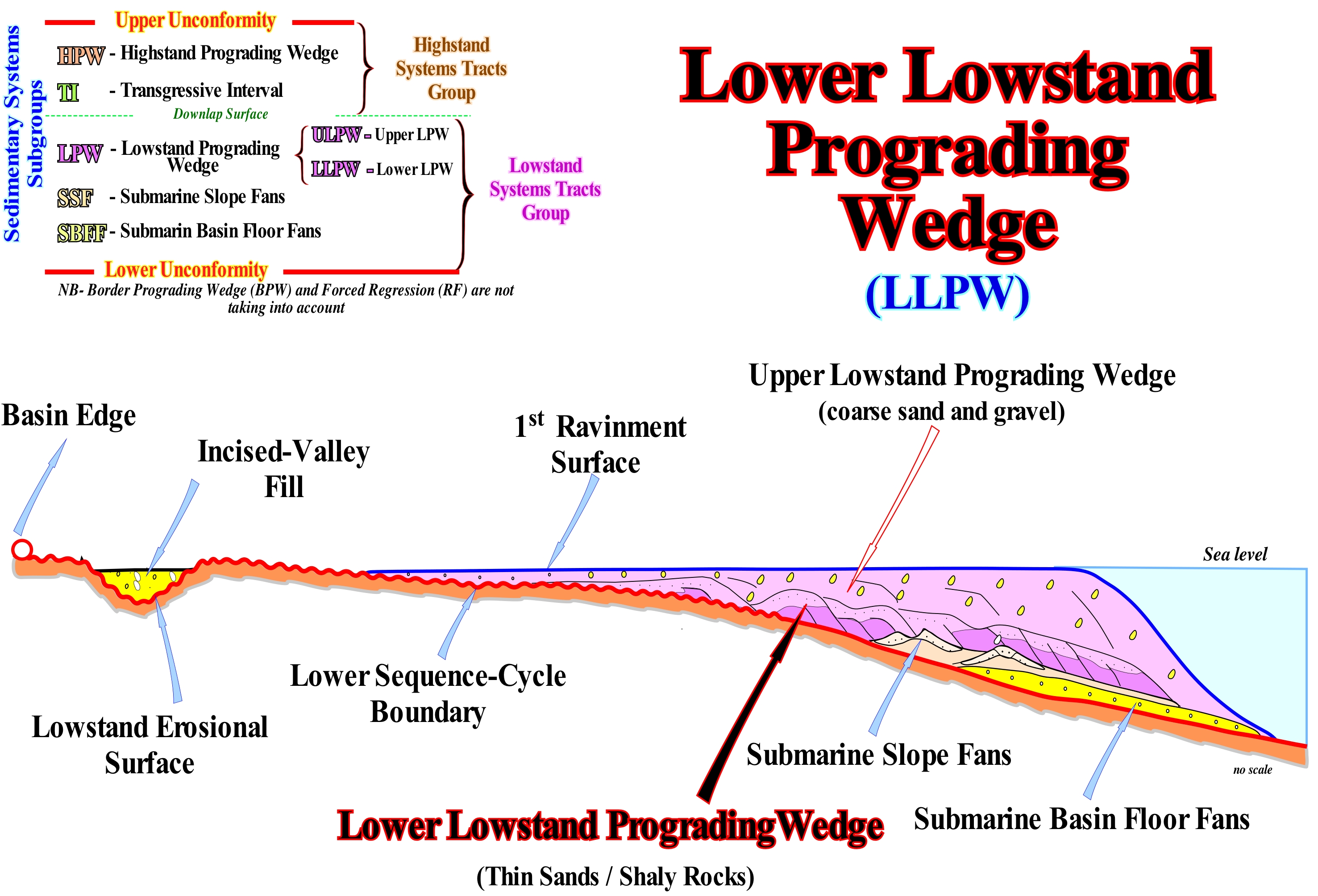
In lowstand geological conditions, i,e, when the sea level (generally, the relative sea level) is lower than the basin edge, which, in these conditions, is the last basin edge of the preceding sequence-cycle. The continental edge of the lowstand deposits and in particular of the lowstand prograding wedge (LPW) can not be considered the basin, since the basin has no shelf. Thus, under lowstand conditions, in a ramp context, the basin by definition has no continental shelf. On the other hand, as the basin edge is the last basin edge of the preceding sequence-cycle, it is, necessarily, not very well marked. As can be seen in the geological sketch illustrated in this figure, taking into account the geometry of the unconformity, which limits the lower sequence-cycle, it can be said there was a, more or less, gradual transition between the coastal prism (coastal wedge), the continental slope and the abyssal plains, before the relative sea level fail, responsible of the unconformity. The coastal prism or coastal wedge is the set of sediments that accumulate in the coastal plain during the progradation of the shoreline, which includes fluvial and shallow water deposits. It has a wedge shape extending to the continent by onlaps over the pre-existing topography. Upstream, the boundary of the coastal prism is the bay-line, which can move upstream when the progradation of the shoreline is accompanied by aggradation. In other words, in a ramp geological context, it is very difficult to locate, exactly, the basin edge, in relation to which the sub-groups of the lowstand systems tracts group (LSTG) will be deposited. In this context, since (i) Submarine Basin Floor Fans (SBFF) ; (ii) Submarine Slope Fans (SSF) and (iii) Lowstand Prograding Wedge (LPW), begin to be deposited as the aggradation is, relatively, small, the individualization of these subgroups is relatively difficult (without taking into account the seismic resolution that further aggravates the problem). On the other hand it should not be forgotten that a sedimentary systems tract is a lateral association of synchronous and genetically linked depositional systems, deposited during the stability period of relative sea level, occurring after each relative sea level rise, i.e., after each eustatic paracycle or marine ingression. During this stability period of relative sea level, one or more sedimentary systems tracts may be deposited. This is obvious when the sequential interpretation is made from the seismic data, since in most of the cases the thickness of a sedimentary systems tract is under seismic resolution (sedimentary regression induced by a single marine ingression). A single marine ingression is an increment of a composite ingression, since a relative sea level rise is not done in a continuum, but in stages, as for instance: (i) Relative sea level rise of 3 m (simple marine ingression) ; (ii) Stability period of relative sea-level ; (iii) Relative sea level rise of 5 m (simple marine ingression) ; (iv) Stability period of relative sea-level ; (v) Relative sea level rise of 7 m ; (vi) Stability period of relative sea-level ; (vii) Relative sea level fall of 10 m (marine regression). In this case, overall, the relative sea level rose by 15 meters, in acceleration (composite marine ingression), since the increments of the marine ingression are, increasingly, important. The terms single and composite marine ingression should be used when clarification is required. Often, even the submarine basin floor fans (SBFF) and the submarine slope fans (SSF) are under seismic resolution, which is much rarer for lowstand prograding wedge (LPW). In some cases, just the upper part of the lowstand prograding wedge (ULPW), which is composed of coarse sediments, is recognized on the seismic lines. During a relative sea level fall, which defines the lower unconformity of a sequence-cycle, submarine basin floor fans (SBFF) an d submarine slope fans (SSF) lie along the ramp (as illustrated in this sketch) and are fossilized by the lower lowstand prograding wedge (LLPW), whose composition is mainly clayey and which deposits when the relative sea level fall begins to decelerate and until it stops falling. As the relative sea level begins to rise, the water-depth increases and the shoreline moves continentward. However, as the terrigeneous influx is important (lowstand geological conditions), the shoreline, gradually, moves seaward, as the progradations (usually sigmoid) of the upper lowstand prograding wedge (ULPW) fossilize the finer deposits of the lower lowstand prograding wedge (LLPW) as illustrated in this sketch.
Lower Lowstand System....................................................................Système inférieur de bas niveau (De la mer)
Sistema inferior de nível baixo (do mar) / Sistema inferior de nivel bajo (del mar) / System weniger Low-Level-(See) / 低水位沉积体系(海)/ Нижняя система низкого уровня моря / Sistema inferiore di basso livello (mare) /
Submarine basin floor fan (SBFF). The group of lowstand systems tract (LST) is composed of three sub-groups: (i) Upper, which consists of incised valley fills, submarine canyons (Pc) fills and lowstand prograding wedge, with which are, sometimes, associated with shingled turbidites ; (ii) Middle, which is composed by the submarine slope fans (SSF) and (iii) Lower, which is composed by submarine basin floor fans (SBFF) and contourites (when present).
See: « Lowstand Systems Tract
&
« Systems Tract »
&
« Lowstand »
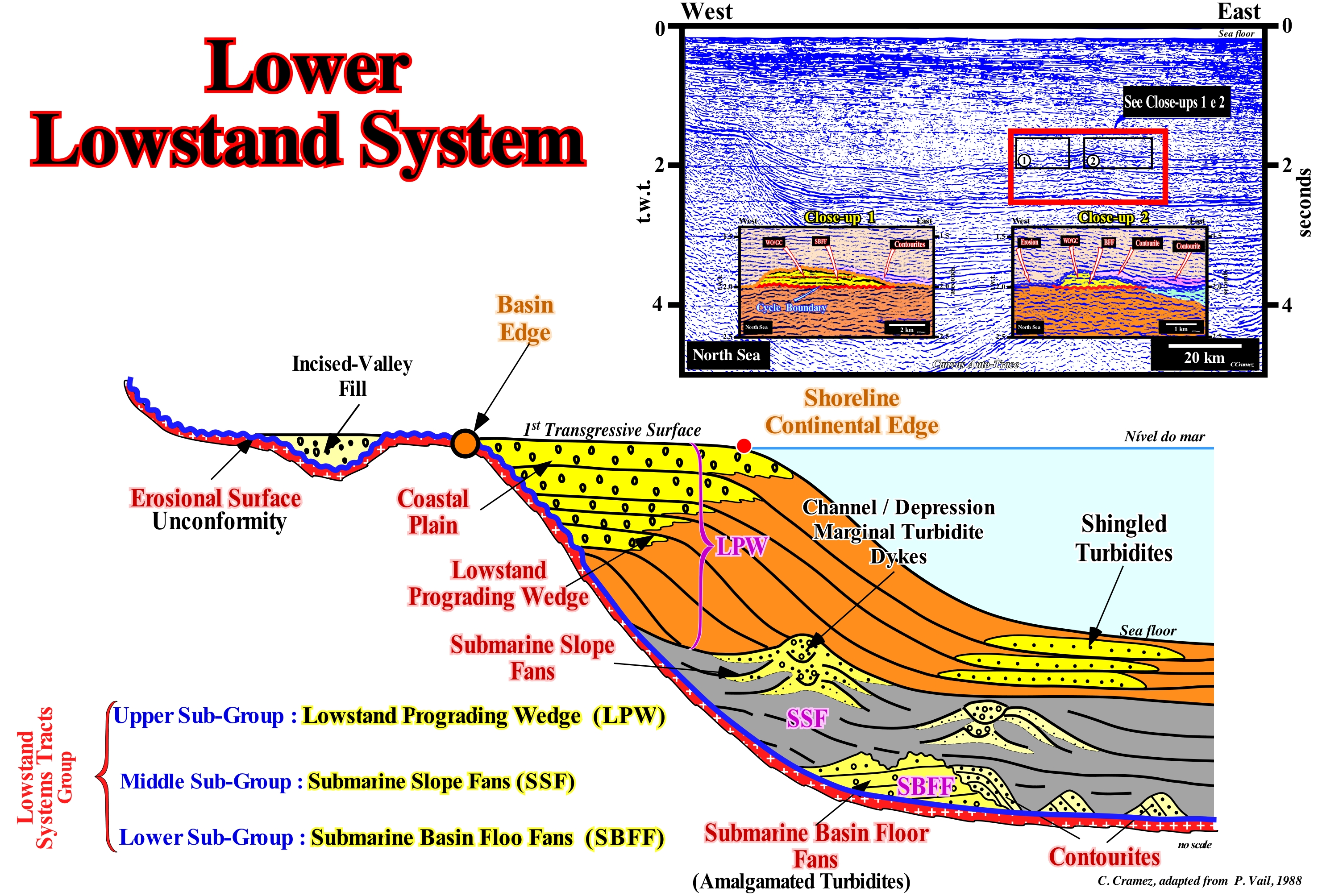
The lowstand systems tracts group (LSTG), which makes the lower part of sequence-cycle, is formed by three sub-groups. From bottom to top, they are: (i) Submarine Basin Floor Fans (SBFF), characterized by having an aggradational geometry and abrupt boundaries, with which contourites* can often be associated, as illustrated in this sketch ; (ii) Submarine Slope Fans (SSF), which have a wavy geometry ("gull-wings" structures of P. Vail), characterized by opposing downlaps, which is, often, well visible when natural marginal dykes turbidites (levees) are well developed and (iii) Lowstand Prograding Wedges (LPW), which consists of a set of sedimentary systems tracts with a prograding geometry and onlaps and toplaps (or truncation) at the top. Submarine basin floor fans (SBFF) deposit during significant falls of the relative sea level. They belong to the only sedimentary systems tracts sub-group that settle without increasing accommodation, i.e., without increasing the available space for the sediments (relative sea level** rise). Submarine slope fans (SSF) are deposited when the relative sea level, after reaching the lowest point of the curve of relative sea level changes, begins to rise. Sedimentary systems tracts forming the lowstand prograding wedge (LPW) deposit when relative sea level rises (in acceleration) before reaching the inflection point of the relative sea level changes curve. Within a sequence-cycle, under lowstand geological conditions, the sedimentary basin has no shelf (continental platform). The sea level is lower than the basin edge, which is the last continental edge of the basin in the underlying sequence-cycle. During the deposition of the lowstand prograding wedge (LPW), the shoreline corresponds, more or less, to the continental edge, as illustrated above, but this edge is not the basin edge. The depositional systems that form the lowstand prograding wedge are shallow-water (coastal plain) and deep-water (prodelta clay or continental slope). Large delta buildings can be deposited under lowstand geological conditions (sea level lower than the basin edge), which means that the geological conditions (highstand or lowstand) have nothing to do with the depositional water-depth. The outer edge of the lowstand prograding wedge coincides, more or less, depositional coastal break of the depositional surface, which is not far from the continental edge, since the basin, at the level of the sequence-cycle, does not have a shelf. All lowstand systems are located downstream of the basin edge (the last continental edge of the preceding sequence-cycle), except the incised valley fills, which deposit during the terminal phase of the lowstand prograding wedge. The formation of an incised valley is contemporaneous with the formation of the lower unconformity of the sequence-cycle (its age is, roughly, the age of submarine basin floor fans). Since an accelerating (more important than the preceding) marine ingression floods the coastal plain of the lowstand prograding wedge and displaces landward the shoreline, it develops a ravinment surface in the pre-existing topography. The basin has shelf and the lowstand prograding edge becomes the new basin edge. During the stability period of relative sea level that follows the marine ingression, the coastline begins to move seaward as the transgressive interval (TI) start to deposit. In the close-ups of the Canvas auto-trace of the North Sea seismic line, shown in this figure, the submarine basin floor fans (SBFF) and the associated contourites, which are the result of the erosion of the submarine basin floor fans by contour currents, can be, easily, recognized.
(*) Deep-water deposits associated with submarine basin floor fans and, genetically, induced by contour currents created by Coriolis force. Lithographically, the contourites are formed by thick packets of fine sand (without clay matrix), with prograding geometry and an ascending slope (climbing toplaps). Some geoscientists, such as Bouma, have called contourites to the deep sea structures (channels filled by a lateral terrigeneous influx), found on the Swiss flysch, which are characterized by a significant abundance of heavy minerals such as zircon, allanite, etc.
(**) Local sea level, referenced to any fixed point on the land surface that may be the base of the sediments or the sea floor and which is the result of the combination of tectonics (whether subsidence or the uplift of the sea floor function of the prevailing tectonic regime) and the absolute (eustatic) sea level, which is supposed to be global and referenced to the Earth's centre. Presently, NOAA, i.e., the National Oceanic and Atmospheric Administration, uses satellite altimetry to determine the absolute sea level. However, the satellite measures must be correctly calibrated by tide-gauge results, i.e., taking into account the subsiding and uplifting site areas, which does seems to be often the case (Mörner, N.A., 2011).
Lowstand.........................................................................................................................................................................................................Bas niveau (De la mer)
Nível baixo (do mar) / Nivel bajo (del mar) / Low-Level-(See) / 低水位(海) / Низкий уровень (моря) / Di basso livello (mare) /
Time interval within a stratigraphic cycle, said sequence-cycle, during which the sea level is lower than the basin edge. During lowstand geological conditions, the basin edge is the last continental edge of the preceding sequence-cycle which, generally, coincides with the last depositional coastal break of the highstand prograding wed (if the sequence-cycle is complete).
See: « Sequence-Cycle »
&
« Highstand »
&
« Relative Sea Level Change »
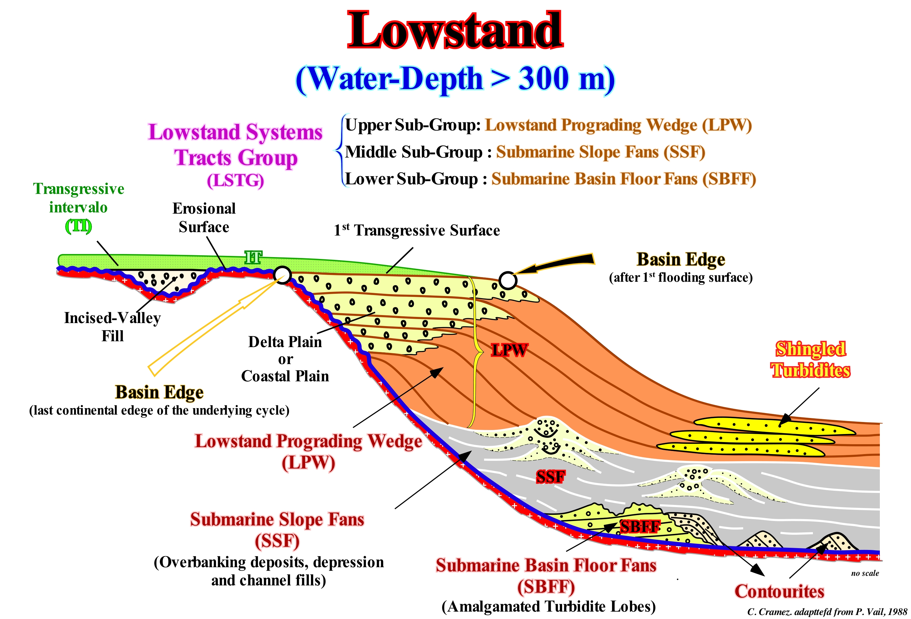
In this sketch, within a sequence-cycle (stratigraphic cycle induced by a 3rd order eustatic cycle, that is, with a time-duration between 3 and 5 My), under the first flooding surface, which emphasizes the end of the deposition of the lowstand prograding wedge (LPW) and above a type I unconformity, which put the relative sea level* underneath the basin edge, are represented the three sub-groups that form the lowstand systems tracts group (LSTG). From bottom to top, they are: (i) Submarine Basin Floor Fans (SBFF), with which, contourites are, often, associated ; (ii) Submarine Slope Fans (SSF) and (iii) Lowstand Prograding Wedge (LPW), with shingled turbidites deposited at the base of progradations of the lowstand prograding wedge. The contourites** are deposits induced by the contour currents*** that erode, locally, the submarine basin floor fans, depositing the sediments not very far with an important depositional dip. Shingled turbidites are, often, associated with instabilities of the continental edge of the lowstand prograding wedge. With the exception of sediments deposited during the first flooding of the coastal plain (or delta plain of the lowstand prograding wedge), all other sedimentary intervals were deposited under lowstand geological conditions. The unconformity, which limits the base of these deposits (including the incised-valley fills), was created by a significant relative sea level fall, which put the relative sea level lower than the basin edge. During this period, the basin edge corresponds to the last continental edge of the highstand prograding wedge (HPW) of the preceding sequence-cycle (if complete, i.e., composed of all sedimentary systems tracts sub-groups), since at the end of the highstand prograding wedge (HPW), in general (second stage of development of the HPW) the basin has no shelf (the shoreline is, more or less, coincident with the continental edge). Except for tectonically enhanced unconformities, the erosion accompanying such a relative sea level fall is insufficient to destroy the morphology of the highstand prograding wedge of the previous sequence-cycle (by definition the time of action of erosive agents is less than 3-5 My). The incised-valley fill, although located upstream of the basin edge, was done under lowstand geological conditions during the last stages of lowstand prograding wedge deposition (early highstand of certain geoscientists). The shift from low to highstand geological conditions corresponds to an acceleration of the relative sea level rise. During lowstand geological conditions, the basin does not have a shelf, which means that, practically and mainly, on seismic lines (taking into account the seismic resolution) the shoreline coincides with the continental edge. All this means that the basin edge during the deposition of the lowstand systems tracts group group (LSTG) corresponds, as illustrated in this sketch to the last continental edge of the preceding sequence-cycle. Within a sequence-cycle, the first transgressive surface, which marks the beginning of the highstand geological conditions, the basin starts to have a continental shelf, the new basin edge is the last continental edge of the lowstand prograding wedge. The first transgressive surface fossilizes the top of the incised valley-fills.
(*) In sequential stratigraphy, geoscientists must always state whether they are talking about relative sea level or if they are speak of the absolute (eustatic) sea level. The relative sea level is a local sand referenced to the base of the sediments (top of the continental crust) or to sea bed. Absolute sea level, which is supposed to be global, is referenced to the Earth centre. Obviously, the relative sea level is the result of the combined action of absolute sea level and tectonics (subsidence or uplift of the sea floor).
(**) Deep-water deposits associated with the submarine basin floor fans, genetically, induced by contour currents created by Coriolis force. Lithographically, the contourites are formed by thick packets of fine sand (without clay matrix), with a progradational geometry and an ascending slope (climbing toplaps). Some geoscientists, such as Bouma, have called contourites to the deep-sea structures (channels filled by a lateral terrigeneous influx), found on the Swiss flysch, which are characterized by a significant abundance of heavy minerals such as zircon, allanite, etc.
(***) Subterranean currents, typical of the continental foothills, which flow along the western boundaries of the ocean basins and occur mainly in regions where the stratification by water density is strong due to to the collection of cold waters originating from the poles.
Lowstand Deposit......................................................................................................................................Dépôt de bas niveau (De la mer)
Depósito de nível baixo (do mar) / Depósito de nivel bajo (del mar) / Ablagerung von Low-Level (Meer) / 低层次的存款(海) / Отложение в условиях низкого уровня моря / Deposito di basso livello (mare) /
Sediments deposited when the sea level is lower than the basin edge. These deposits are located downstream of the depositional coastal break of the preceding highstand interval (basin edge). They can be basin, slope or littoral deposits depending on the relative positions of the bay-line and equilibrium point to the depositional coastal break and basin edge. It is not proper to associate lowstand deposits with deep-water sediments. Many of the lowstand prograding wedge sediments are deposited under a small water-depth. In particular cases, lowstand deposits may be deposited when the sea level is above the basin edge, but lower than the depositional coastal break (the bay-line and the equilibrium point are downstream of the depositional coastal break). In a sequence-cycle, the lowstand systems tracts group is formed by three sub-groups: (i) Submarine Basin Floor Fans (SBFF) ; (ii) Submarine Slope Fans SSF) and (iii) Lowstand Prograding Wedge (LPW). In relation to the curve of the available space variation of a sequence-cycle, the submarine basin floor fans are deposited when the 1st derivative of the function (curve) is maximum (unconformity). Submarine slope fans (SSF) are deposited when the 1st derivative is negative and 2nd is the positive (decreasing function). On the other hand, the lowstand prograding wedge (LPW) is deposited during the sector of curve (available space variation) characterized by having the 1st derivative positive and the 2nd derivative also positive (increasing function with concave geometry), i.e., relative sea level rises in acceleration.
See: « Highstand Deposit »
&
« Relative Sea Level Change »
&
« Lowstand »
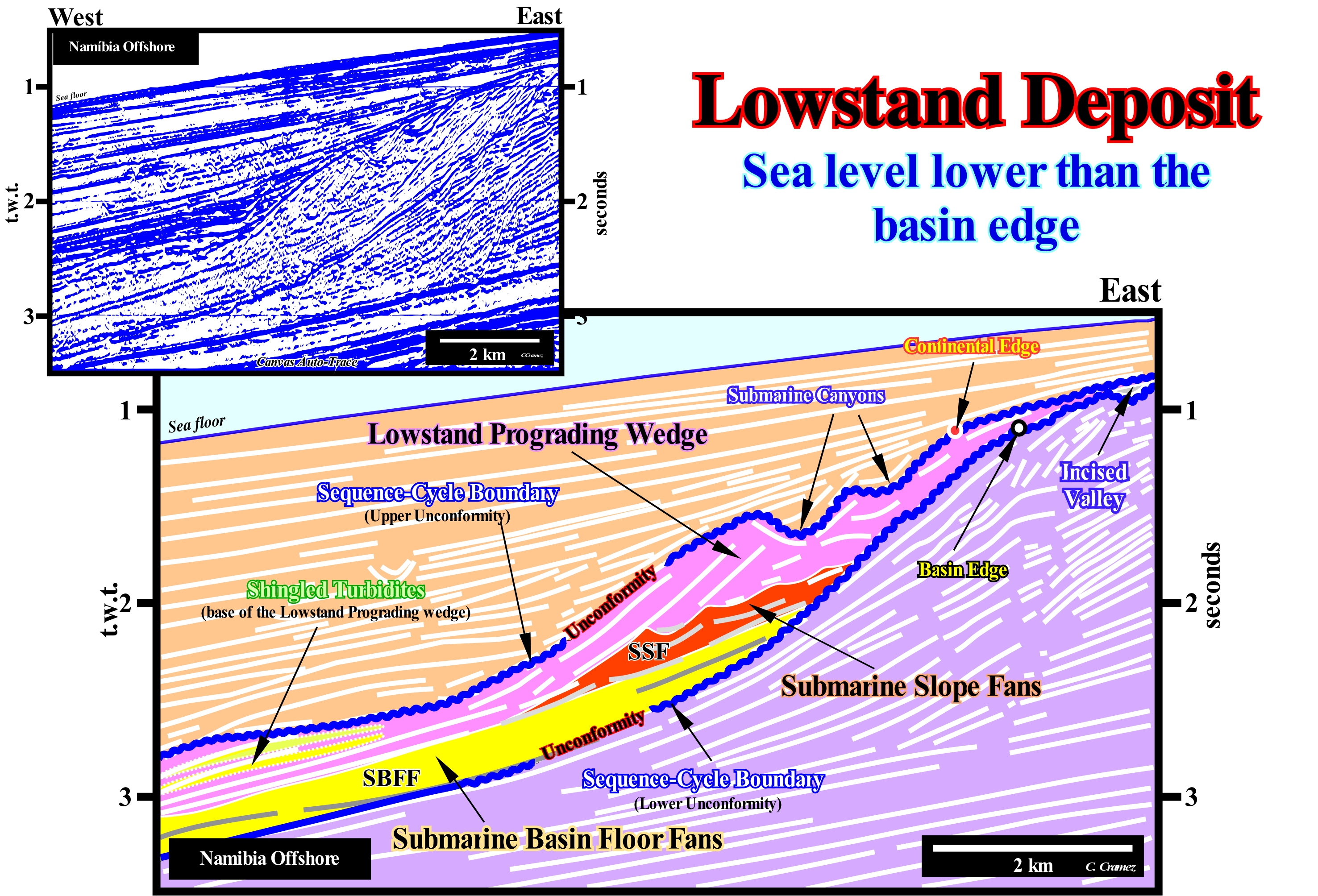
On this tentative geological interpretation of a Canvas auto-trace of a detail of a Namibia offshore seismic line , it is easy to recognize a stratigraphic cycle called the sequence-cycle, induced by a 3rd order eustatic cycle, i.e., an eustatic cycle with a time-duration between 0.5 Ma and 3-5 My. This sequence-cycle, as all sequence -cycles, is bounded by two unconformities (blue-coloured wavy lines), i.e., bounded by two erosional surfaces created by two significant successive relative sea level fall resulting of the combination of absolute (eustatic) sea level, which is supposed to be global and referenced to the Earth's centre and tectonics (subsidence of the sea floor, when the predominant tectonic regime is in extensional or uplift when the predominant tectonic regime is in compressional). It may be said that each unconformity corresponds to a hiatus surface, along which the gap decreases basinward. The upper unconformity is characterized by onlap surface of the overlying sediments. The lower unconformity may be characterized by the onlaps of the internal reflection terminations of the cycle-sequence. The great majority of reflectors with reservoir-rock characteristics terminate by onlaps against the unconformity which limits, at bottom, the cycle-sequence, which can also be put in evidenced ±by the toplaps of the underlying sediments. This is one of the main reasons why sequential stratigraphy is, widely, adopted by geoscientists working in the oil industry, since one of their main concerns is the location of reservoir-rocks within potential traps. As can be seen, on this tentative interpretation, the illustrated sequence-cycle is incomplete. The highstand systems tracts sub-groups, i.e, the transgressive interval (TI) and the highstand prograding wedge (LPW), which form, normally, the highstand systems tracts group (HSTG), were not deposited. Just the lowstand systems tracts sub-groups were deposited. From bottom to top, these sub-groups are: (i) Submarine Basin Floor Fans (SBFF), coloured in yellow ; (ii) Submarine Slope Fans (SSF), coloured in red and (iii) Lowstand Prograding Wedge (LPW), coloured in violet. In association with the lowstand prograding wedge (LPW), one can recognize in the upper part (Eastward), an incised valley fill and, in the lower part (Westward), a set of shingled turbidites (proximal turbidites). The filling of the incised-valley is synchronous with the deposition of the upper part of the lowstand prograding wedge (LPW). Shingled turbidites are deposited on the base of the progradation of the lowstand prograding wedge following failures and ruptures of the continental edge (at the top of the lowstand prograding wedge). The wavy geometry ("gull wings" structures of P. Vail) of the submarine slope fans (SFF) contrasts with the parallel geometry of the submarine basin floor fans (SBFF). The first is associated with natural marginal dykes (levees) and the depression or channels (in case of erosion) fills between them. The parallel geometry is associated with the turbidite lobes of the submarine basin floor fans. As suggested on this tentative interpretation, the age of the unconformities, which limit this incomplete sequence-cycle is given by the age of the overlying submarine basin floor fans. They fossilize the smaller depositional hiatus between the sediments underlying and overlying the sequence boundaries. It is important to note that in the deep parts of the basin, the sequence boundaries are not the unconformities but their correlative deep-water paraconformities, since there is any attitude difference between the overlapping and underlying intervals, but just an hiatus due to the absence of deposition between them.
(*) In general, absolute sea level is calculated using measures using from a radar satellite (Ers-1 or Ers-2 type), whose radiation (± 5.6 cm wave-length) is not affected by small drops and particles that exist in the clouds. This technique of interferometry consists of comparing several radar images of the same zone taken during successive passages of the satellite. At each passage the difference of the round trip between the satellite and a particular point of the image (target point) is measured. Although the distance between the satellite and the sea level is at best about a few tens of centimeters, the variations of this distance from one passage to the next can be calculated with a precision of a few millimeters. Such a variation may have different origins, the simplest and the most interesting being the displacement of the target point, that is, the sea level. However, the satellite measures must be correctly calibrated by tide-gauge results, i.e., taking into account the subsiding and uplifting site areas, which does seems to be often the case (Mörner, N.A., 2011).
Lowstand Prograding Wedge...........................................................................................................Prisme de bas niveau
Prisma de nível baixo / Prisma de bajo nivel / Prisma Low-Level / 低水位前积楔 / Клин размывания низкого уровня моря / Prisma basso livello /
Progradational sedimentary package deposited in lowstand geological conditions. The lowstand prograding wedge (LPW) is deposited on the continental slope since the basin has no continental shelf. Under normal conditions, at its highest deposition level, when the 1st transgressive surface, it fossilizes the basin edge, which becomes the continental edge. In other words, in a sequence-cycle (SC), during the deposition of the lowstand prograding wedge, the basin edge is the last basin edge of the preceding sequence cycle. However, since the first transgressive surface, basin edge becomes the continental edge (outer limit of the coastal plain of the lowstand prograding wedge).
See: « Sequence-Cycle »
&
« Lowstand Systems Tract
&
« Systems Tract »
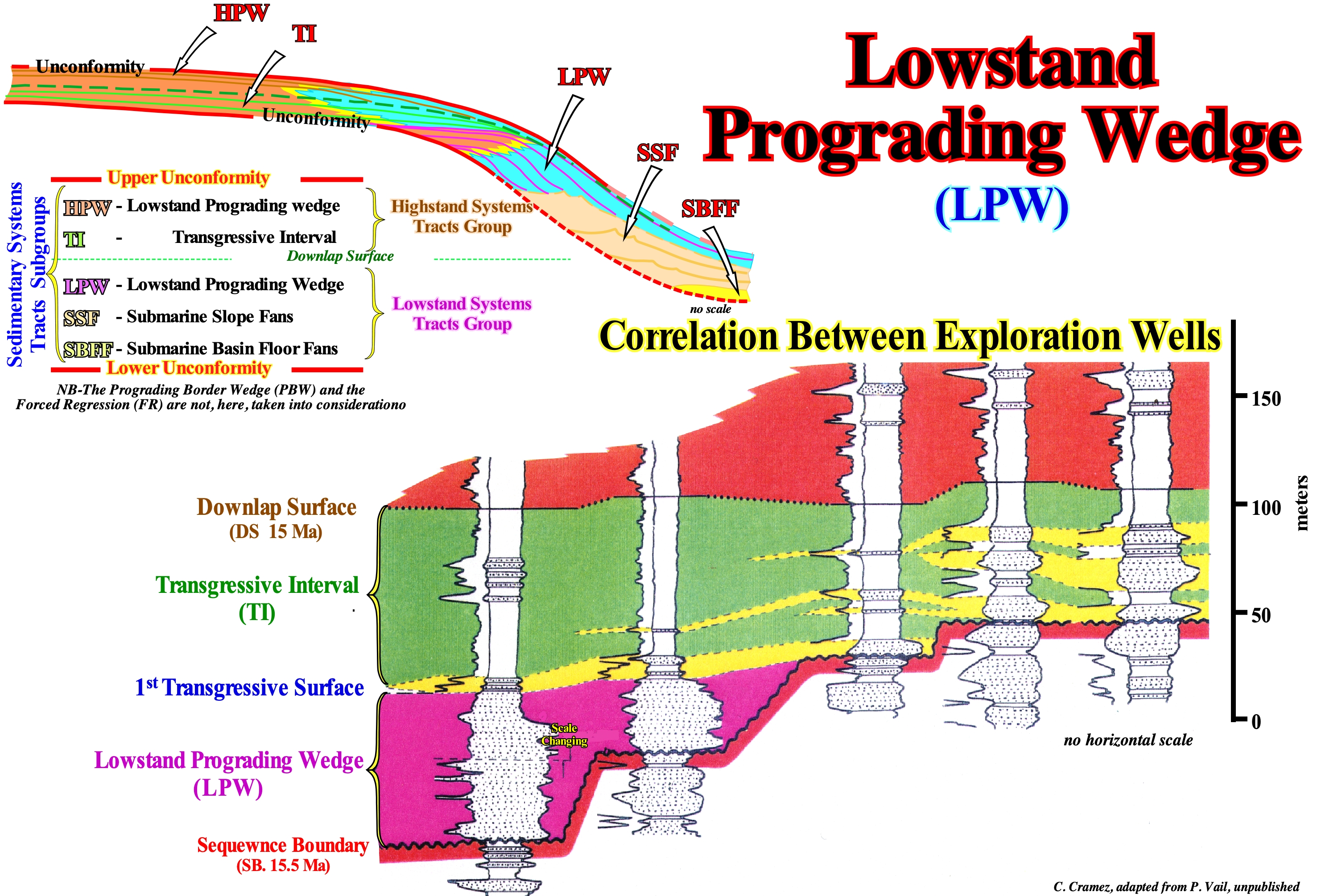
In a stratigraphic cycle called the sequence-cycle, between the lower unconformity and the upper unconformity, the age difference is less than 3-5 My, since a sequence-cycle is induced by a 3rd order eustatic cycle (*), which time-duration is between 0.5 and 3-5 My. Two groups of sedimentary systems tracts may be recognized in a sequence-sequence: (i) Lowstand Systems Tracts Group (LSTG), during which the sea level (absolute or relative) is, always, lower than the basin edge and (ii) Highstand Systems tracts Group (HSTG), during which the sea level (absolute or relative) is, always, higher than the basin edge. In a complete sequence-cycle, excluding the presence of a forced regression (FR) or of a bordering prograding wedge (BPW), within the lowstand systems tracts group there are three sub-groups: (a) Submarine Basin Floor Fans (SBFF) ; (b) Submarine Slope Fans (SSF) and (c) Lowstand Prograding Wedge (LPW), which, as the name implies, has a predominant prograding geometry. Within the highstand systems tracts group (HSTG) there are at least two sub-groups of courts (**): (i) Transgressive Interval (IT) and (iii) Highstand Prograding Wedge (HPW). As within a sequence-cycle, sediments. generally. settle down during the stability period of relative sea level following an eustatic paracycle (marine ingression or increments of a composite marine ingression) and not during the rising of the relative sea level, several sedimentary systems tracts (lateral associations of synchronous and genetically linked depositional systems) can be recognized within a paracycle-sequence (sedimentary regression induced by an eustatic paracycle). During lowstand systems tracts group (LSTG), the basin edge is the last edge of the basin edge of the preceding sequence-cycle, which means that the continental edge (in particular of the of the lowstand prograding wedge) does not emphasize the basin edge. During the transgressive interval (TI) and highstand prograding wedge, which are highstand systems tracts sub-groups, the geological conditions are highstand, which means that since the relative sea level flooded the coastal plain of lowstand prograding wedge, the basin edge, which was the last basin edge of the basin of the preceding cycle, became the continental edge (the last edge of the coastal plain of the lowstand prograding wedge). The transgressive interval (TI) has a geometry, globally, retrogradational (the sequence-paracycles are increasingly smaller, while the marine ingressions are increasingly important or, as certain geoscientists say, the relative sea level (***) rise in acceleration). The geometry of the highstand prograding wedge (HPW) is progradational (the depocenters of the sequence-paracycles, which it, it migrate seaward). This geometry is, easily, explained, since the marine ingressions become less important (relative sea level rise in deceleration) and the associated sedimentary regressions increasingly important. In this figure illustrates a stratigraphic correlation (in sedimentary systems tracts sub-groups) proposed by P. Vail, between five exploration wells in Venezuela onshore. The unconformity SB 15.5 Ma, which is the lower boundary of the SB 15.5 - SB 13.8 Ma sequence-cycle, is, easily, recognized in all wells. The most distal wells penetrated the lowstand prograding wedge (LPW) seaward of the basin edge. Above the basin edge, which is the last basin edge of the preceding sequence-cycle, the lower unconformity (SB 15.5 Ma) was directly covered by the marine ingression responsible for the deposition of the transgressive interval (TI). From such a moment on (1st transgressive surface), the basin had a shelf and the continental edge, marked by the lowstand prograding wedge (not visible in this correlation), became the new basin edge.
(*) A third order eustatic cycle, contrary to a first order eustatic cycles (time-duration greater than 50 My) and probably also to 2nd order eustatic cycles (time-duration between 3-5 My and 50 My), are determined from the curve of relative sea level changers and not from the curve of the absolute (eustatic) sea level.
(**) The Bordering Prograding Wedge (BPW) or Forced Regression (FR), which may exist in particular cases, are not taken into account here.
(***) The relative sea level is the local and, generally, referenced to the sea floor or to the base of the sediments (op of continental crust). It is the result of the combined action of tectonics (subsidence or uplift of the sea floor)and the absolute (eustatic) sea level, which is supposed to be global and referenced to Earth's centre.
Lowstand Systems Tract (Group of systems tracts)...............................Cortège de bas niveau (De la mer)
Cortejo de nível baixo / Cortejo do nivel bajo (del mar) / Prozession der Low-Level (See) / 低层次的游行(海) / Тракт системы низкого уровня моря / Processione di basso livello /
One of the sedimentary systems tracts that form the set of submarine basin floor fans (SBFF), submarine slope fans (SSF) and the lowstand prograding wedge (LPW), which are the sub-groups of the lowstand systems tract group o(LSTG). Within a complete sequence-cycle, the lowstand systems tract is formed by three subgroups: (i) Submarine basin floor fans (SBFF) ; (ii) Submarine slope fans (SSF) and (iii) Lowstand prograding wedge (LPW). All these sub-groups of sedimentary systems tracts are deposited when the sea level is below the basin edge, which corresponds, generally, to the last basin edge of the preceding sequence-cycle. In relation to the relative sea level changes that define the sequence-cycle, the lowstand systems tract group is deposited when the relative sea level has, practically, reached the lowest point of the curve (available space) and begins to rise, progressively, and in acceleration. In the available space curve, during a sequence-cycle, the segment during which the lowstand prograding wedge (LPW) and the transgressive interval (TI) are deposited has the 1st and 2nd derivatives positive (the function is increasing and has a geometry concave, which means that the rate of relative sea level rise is acceleration). The segment during which the highstand prograding wedge (HPW) is deposited has the 1st positive derivative, but the 2nd derivative is negative (the function is increasing and has a convex geometry or, in other words, the rate of rise of the level of the sea is in deceleration). The deposition occurs during the period of relative sea level stability following each of the eustatic paracycles.
See: « Systems Tract »
&
« Sequential Stratigraphy »
&
« Highstand »
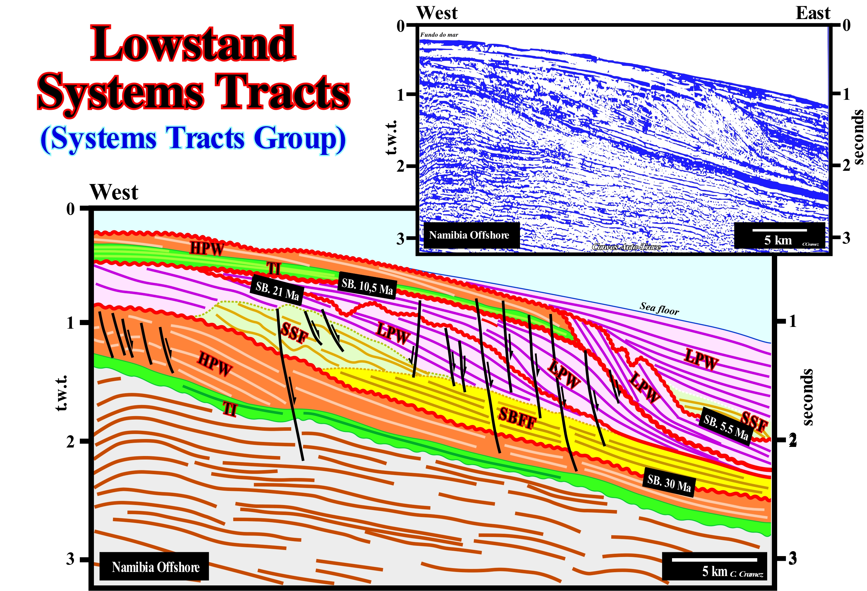
The lowstand systems tracts group (LSTG)*, when complete, consists of three subgroups: (i) Submarine Basin Floor Fans (SSF) ; (ii) Submarine Slope Fans (SSF) and (iii) Lowstand Prograding Wedge (LPW). The geometry of the submarine basin floor fans is aggradational, whereas the geometry of the submarine slope fans is wavy. The Peter Vail's "gull wings" structures, i.e., the natural marginal dykes (levees) and depressions (channels when there is erosion) complexes are characteristic of the submarine slope fans. The geometry of the lowstand prograding wedge (LPW) is progradational. On this tentative geological interpretation of a Canvas auto-trace of a detail of a Namibia offshore seismic line, the continental encroachment sub-cycles are individualized by unconformities (red wavy lines). The age difference between each of these unconformities (SB 5.5 Ma, SB 10.5 Ma, SB 21 Ma and SB 30 Ma) is greater than 3-5 My and less than 50 My. That means these seismic intervals were deposited in association with 2nd order eustatic cycles, whose time-duration varies from 3-5 My to 50 My, which, probably, were induced by significant tectonic subsidence changes (large scale sinking of the Earth's crust, in relation to certain crustal areas or in relation to the geoid, by lengthening, cooling or loading). Therefore, these sedimentary intervals can be considered as continental encroachment sub-cycles. However, as can be seen on this tentative interpretation, these continental encroachment sub-cycles are composed of sequence-cycles, which, at this scale, are, relatively, difficult to individualize. Taking into account the geometry of the reflectors, it is possible to predict that most of the continental encroachment sub-cycles are composed by a lateral aggregation of sequence-cycles formed just by lowstand prograding wedges (LPW). This is obvious since the Upper Miocene (SB 21 Ma). In fact, above the unconformity SB. 30 Ma, which probably corresponds to a significant fall of the absolute (eustatic) sea level (supposed global and referenced to the Earth's centre) induced by the formation of the Antarctic ice cap, a package of submarine basin floor fans , deposited during several sequence-cycles is easy to recognize by their aggradational geometry (yellow colored interval). Upstream of this sedimentary package, another is recognized, with a wavy geometry. It can be interpreted as a stacking of submarine slope fans, also, associated with several sequence-cycles. At present-time, the water-depth, strongly, suggests highstand geological conditions. The sea level is higher than the basin edge (probably located about 5 km east of the west end of the auto-trace). All geoscientists know that, currently, there is a shelf off the Namibia shoreline. The most recent sedimentary interval, as illustrated on the tentative interpretation, is a lowstand prograding wedge (LPW), what means since its deposition, a significant absolute (eustatic) sea level rise took place. Indeed, the maximum extent of ice caps and ice seas during the last ice age is, relatively, well known. The maximum expansion was reached at about the same time, roughly 19 ka in the northern and southern hemispheres. Then the ice began to melt. The retrogradation of the Antarctic ice cap, for instance, which is now about 450 km (± 24 m per year), has contributed, strongly, to the 120-130 meters of absolute sea level rise after the glaciation. The contribution of the ice seas is zero or even negative, since the water is denser than ice. To conclude, it can be said within a complete sequence-cycle, the lowstand systems tracts group (LSTTG) is formed by three sub-groups: (i) Submarine Basin Floor Fans (SBFF), which have a mounded geometry and deposited during relative sea level falls ; (ii) Submarine Slope Fans (SSF), which have a wavy geometry and are deposited during the final part of the relative sea level fall and (iii) Lowstand Prograding Wedge (LPW), which has progradational geometry and is deposited as long as the relative sea level begin to rise.
(*) This terminology has nothing to do with the depositional water-depth depth of the intervals forming the lowstand systems tracts group. The sedimentary intervals forming this group of systems tracts do not necessarily deposit under a great water-depth, although this is the case of the submarine fans. The depositional water-depth of the sediments forming the lowstand prograding wedge (LPW) is very weak in the proximal area and, relatively, important in the distal area, since the lowstand prograding wedge geometry is progradational.
Lumachel (Coquina)...................................................................................................................................................................................................Lumachelle
Lumachela / Lumachela, Coquina (roca) / Coquina (rock) / Coquina(岩) / Ракушечник / Lumachella /
Detrital limestone, slightly or moderately, cemented and composed of fragments of shells. Clastic limestone composed, mainly, of fragments of fossils, which suffered a considerable abrasion and transport before reaching the deposition site.
See: « Limestone »
&
« Detritus, Debris »
&
« Reservoir-Rock (HC) »

As illustrated in this photograph, a lumachel, sometimes called coquina (Spanish term meaning shell) or calcarenite, is an endogenous rock constituted by deuterogenic sediments, mainly fragments of shells. Because the shells are made of calcium carbonate, lumachels can be considered as endogenous limestones (formed by debris), but not protogeneous (formed by precipitation of calcium carbonate). The lumachels are formed near the shoreline, where the wave action is strong and able to select the sediments, as suggested by the broken but polished particles (by the abrasion of the sea-waves) that constitute them. Many limestone rocks have fossils, but the lumachels are, exclusively, fossils, as can be seen in the lumachel illustrated in this figure. A very cemented lumachel or coquina is, often, referred to as a coquinite, as well as a limestone consisting mainly of shell fossils, which lived where they were deposited (in situ or in situ), sometimes, is called conchoidal limestone. Some geoscientists go further and differentiate the lumachels and allochthonous conchoidal limestones (formed by fragments that were not transported) from the native lymphocytes and conchoidal limestones (formed by fragments that were transported from other sites). Many lumachels are formed from reef and sub-reefal material. This facies is, mainly, represented near reefs and often contains green algae of the genera Gymnocodium, Macroporella and Mizzia. Also fusilins and gastropods can be very frequent. The lumachels were used as a paving material, since being little cemented, they easily split into their components (fragments of coral reefs) and thus can replace the gravel obtained by rock fragmentation, which is much more expensive to obtain. On the other hand, since lumachels, often, contain phosphorus-rich compounds, they are used in some countries as fertilizers.
Lutite (Pelite)..............................................................................................................................................................................................................................................Lutite
Lutito / Lutita / Lutit / 泥质 / Лютит, пелит / Pelito, Lutito /
Any sedimentary rock with clay grains and silts with a diameter lesser than 1/16 mm. The term lutite is, also, used for limestone when the granulometry is equivalent to that of a clay or silt.
See : « Siltite »
&
« Granulometry »
&
« Clay »
Lutites, also called pelites, are a class of clastic sedimentary rocks whose elements have a diameter of less than 1/16 mm (less than 63 microns). The term most commonly used to describe sediments composed of this type of particles is silt or clay for the smallest (less than 20 microns). For consolidated (cemented) sediments the terms siltite and argillite are, sometimes, used. Originally (in English) the term argillite implies a small metamorphism. The lutites appear, sometimes, in a clayey form (claystone), which gives them a strong retention to the water, i.e., a small permeability. As illustrated in this figure, lutites, are often, associated with precious stones, such as emeralds. In the famous mines of the Muzo region (Colombia), the emeralds are associated with a breccia of lutites and calcite. The term lutite is, also, used to classify clastic limestones. Pettijohn gives the following descriptive limits on the basis of grain size, avoiding the use of terms such as "clay" or "clayey" that imply a certain chemical composition: (i) Gravel, psephite (Greek), rudy (Latin) ; (ii) Sand, psammite (Greek), sandstone (Latin) and (iii) Clay, pelite (Greek), shale (Latin). In English, function of the grain-size, the lutites are called "Claystones", "Siltstones" or "Schists". The lutites undergoing compaction (sediment weight or tectonic stress) develop a preferential fissiliness and are called "schists". These English terms have been translated by certain geoscientists, but, often, the proposed translation does not correctly translate the definition of the original term. The most striking cases are the Portuguese translation "xisto", "argilito" and "argila", since "xisto" is, in reality, a metamorphic rock, "argilito" is an anchi-metamorphic rock and "argila" is not a rock, but rather a sedimentary particle. On the other hand, the term "shale" of the Portuguese geoscientists do not corresponds, more or less, to a clay.
Lysocline..........................................................................................................................................................................................................................................Lysocline
Lisoclina / Lisoclina / Lizoklin / 溶跃面 / Лизоклин / Lisoclina /
Depth of the ocean below which the rate of dissolution of calcite increases significantly. Underneath the lysocline there is a depth known as the carbonate compensation depth (CCD), below which the rate of calcite input balances the rate of dissolution, which means that there is no deposit of calcite.
See: « Calcite »
&
« Compensation Depth (carbonates) »
&
« Dissolution »
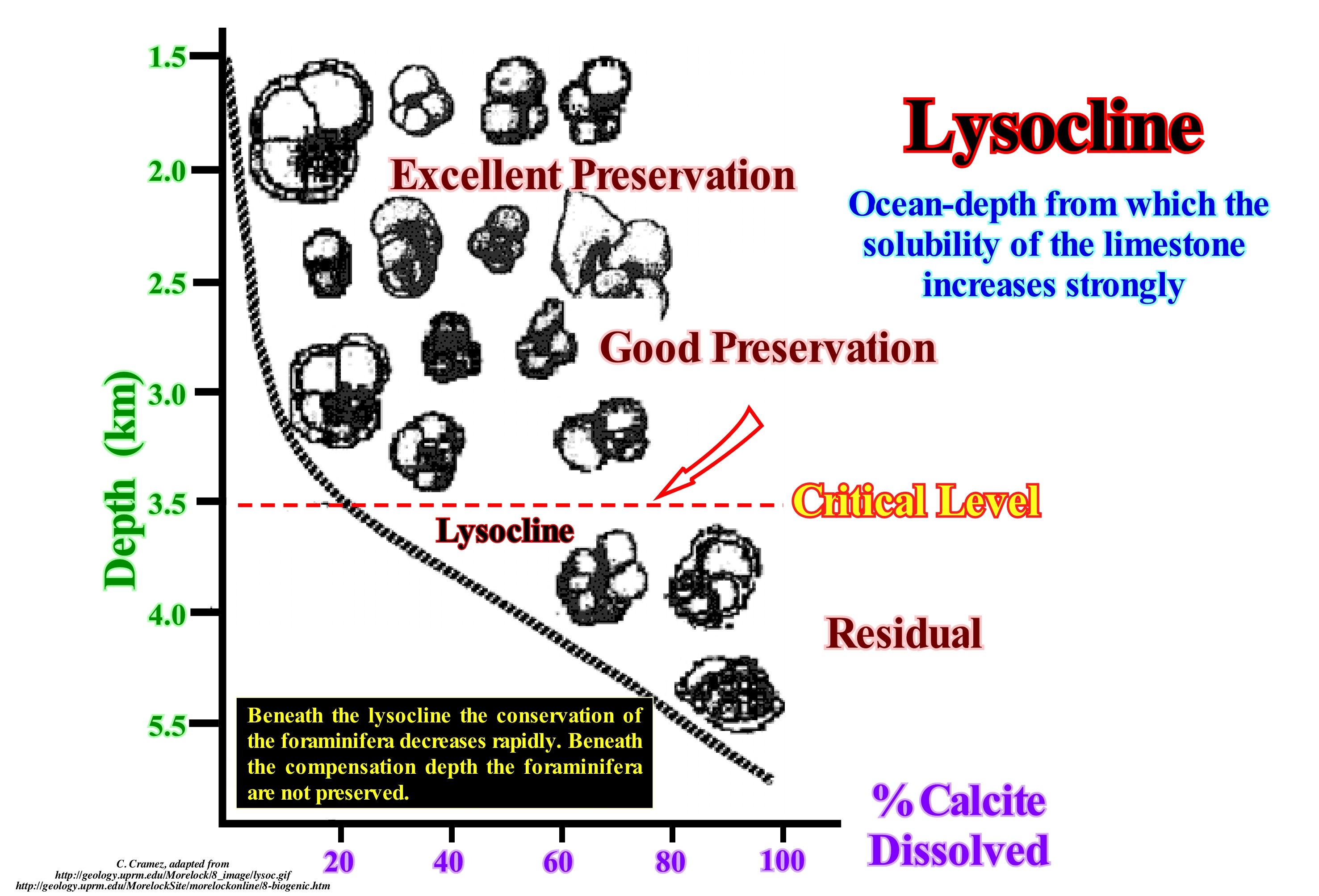
The lysocline is the depth under which most of the sediment carbonates in the ocean floor dissolve. At this level only the most resistant carbonates, such as limestone foraminifera, remain, without dissolving, whereby sediments still contain carbonate remains. There is a second level, the so-called "calcite compensation level" or "calcite compensation depth" (NCC/PCC, or CCD, meaning "Calcite Compensation Depth"), under which the totality of the carbonates dissolves. The chemical reaction can be translated as: CaCO3 + H2O + CO2 → Ca2+ + 2HCO3-. The lysocline is, currently, between 3,000 and 5,000 meters deep, corresponding, more or less, to the average depth of the oceans. Lysocline can vary according to multiple factors, including CO2 concentration, water acidity level, or latitude, reaching places like Antarctica just a few hundred meters below the surface. The necessity of a certain depth for the dissolution of carbonates is due to the solubility of the same increase with the decrease of the temperature and with the increase of the pressure. It is precisely this temperature dependence that causes lysocline and PCC not to be parallel in the ocean, with the CCD being, generally, farthest from lysocline in the centre of the ocean basin and near the banks. At other times lysocline has undergone important variations, for example 55 million years ago during the Paleocene / Eocene Thermal Maximum (MTPE), where it rose, drastically, all over the planet due to the increase in temperature and CO2 (http: //fr.wikipedia.org/wiki/Lysocline). This transient global warming interval (± 55 Ma) is associated with ecosystem transformation and changes in the carbon cycle and, probably, caused by the entry of large amounts of CO2 and CH4 into the ocean / atmosphere system.

